Submitted:
20 February 2026
Posted:
24 February 2026
You are already at the latest version
Abstract
Lokoja, the capital of Kogi State, Nigeria, is a rapidly growing mid-sized city located at the confluence of the Niger and Benue Rivers. While this location has driven urban expansion, it has simultaneously increased the city’s exposure to environmental risks, particularly flooding and ecosystem degradation. Despite their growing importance, cities of this scale remain underrepresented in African urban research. Using multi-decadal Landsat imagery (2000, 2010, 2020, and 2024), Random Forest supervised classification, and PyLandStats landscape metrics, this study examines the spatio-temporal dynamics of urban growth and landscape fragmentation in Lokoja. Results reveal a non-linear urban trajectory characterized by rapid expansion (2000–2010), partial consolidation (2010–2020), and renewed densification with intensified fragmentation (2020–2024). Urban land cover expanded from 6,668 ha in 2000 to 19,371 ha in 2010, declined to 12,883 ha in 2020, and increased again to 15,985 ha by 2024, representing a net growth of approximately 140%. Urban expansion has imposed severe ecological costs. Dense forest cover declined by 99.7% (from 373 ha to 1 ha), while woodland areas were reduced by 73.9%. Core habitat declined from 23% to 13.8% of the landscape, falling below the 15–20% threshold associated with ecological functionality. Edge density increased by 121%, amplifying urban heat island effects, surface runoff, and biodiversity loss. Although grassland cover increased by 77.1%, this reflects secondary succession rather than ecological recovery, given an estimated loss of 3,000 ha of original vegetation. The study recommends enforcing development restrictions below 10 m elevation with 100 m riparian buffers, restoring 500 ha of native riparian corridors, mandating a minimum of 20% urban tree canopy cover, and institutionalizing community-based monitoring of green spaces. These findings contribute empirical evidence on the sustainability challenges of mid-sized African cities and offer transferable planning strategies for ecologically sensitive urban regions.
Keywords:
biodiversity
; GIS
; habitat fragmentation
; land use change
; Lokoja
; urban expansion
1. Introduction
Urban expansion refers to the outward spread of population, built-up areas, and associated human activities beyond existing administrative or physical boundaries. It is largely driven by population growth, economic development, and increasing demand for housing, transportation networks, and urban infrastructure (UN-Habitat, 2016; Seto, Güneralp & Hutyra, 2012). According to Seto et al. (2012) and Angel et al. (2011), urban growth is increasingly pushing residential, commercial, and industrial activities beyond city boundaries into surrounding peri-urban and rural areas, where agricultural lands and natural ecosystems are progressively transformed to accommodate expanding human activities.
Although urban expansion, in general, can be considered a good thing for socio-economic development, it usually comes at the cost of natural ecosystems, which are either fragmented into smaller patches or completely transformed into urban areas. Recent studies show that Lokoja, the capital of Kogi State, Nigeria, has undergone rapid urban expansion in recent years. A steadily increasing population largely drives this growth, now estimated at 900,000 people, the city’s strategic role as an administrative centre, and the continuous spread of road networks, housing developments, and commercial activities (Avis, 2019; Odaudu, 2019; OECD/SWAC et al., 2025).
Urban expansion in sub-Saharan Africa, notably Nigeria, has grown into contemporary and often disorganized cities, bringing about changes in land use and environmental challenges (UN-Habitat, 2016; Korah et al., 2024; OECD/SWAC et al., 2025). Lokoja offers a clear illustration of these trends, as a medium-sized city located at the junction of two rivers, where the pressures of peri-urban expansion and informal urban development are highly visible (Avis, 2019; Allu-Kangkum & Umar, 2025). The rapid growth of urban land area has caused dramatic shifts in land use such as wetlands, farmlands, and savanna woodlands being turned into residential, commercial, and industrial zones which are at the same time, posing very difficult issues of environmental sustainability and urban planning (Adelekan, 2016; Adegun, 2021; Faisal Koko et al., 2021; Ogunbode et al., 2025).
Wetlands, which naturally function as natural flood-retarding basins and provide habitats for diverse aquatic species, are increasingly being drained for building and infrastructural development. This transformation has led to heightened flood risk, reduced groundwater recharge, and disruption of natural nutrient cycling processes. Similarly, savanna woodlands that are rich in non-timber forest products are under growing pressure. Rapid land clearance for fuelwood extraction, road construction, and expanding urban infrastructure has accelerated biodiversity loss and habitat fragmentation, thereby diminishing the availability of critical natural resources (Fanan et al., 2011; Fabolude et al., 2023).
Urban expansion in Lokoja is characterized by scattered, leapfrog settlements that encroach into surrounding natural areas, placing growing pressure on infrastructure such as roads, water supply, and energy systems. This pattern of growth has contributed to habitat fragmentation, biodiversity loss, and the depletion of critical ecosystem resources. Environmental challenges—including soil erosion, altered drainage, and increased flood risk—have become more pronounced, particularly along the Niger and Benue Rivers. These spatial dynamics have also exacerbated deteriorating water quality, rising air pollution, and ongoing biodiversity decline, raising serious concerns about the city’s long-term environmental sustainability (Akubia & Bruns, 2019; OECD/SWAC et al., 2025). Remote sensing and GIS analyses reveal substantial reductions in vegetation and wetland areas alongside a high annual increase in urban land cover (Angel et al., 2021; Faisal Koko et al., 2021). Collectively, these pressures underscore the urgent need for proactive monitoring and management of urban expansion. Mapping and analyzing the spatio-temporal patterns of land use change will be essential for informed decision-making on sustainable development, protection of natural habitats, and mitigation of the ecological impacts of urban sprawl (Adeoye, 2012; updated in Ogunbode et al., 2025).
Natural habitats are indispensable for the maintenance of biodiversity, the provision of ecosystem services, and the promotion of urban resilience. They are the plants' and animals' main source of shelter, thus preserving genetic diversity and keeping the ecological balance in the areas that are rapidly turning into urban centers (Chapin et al., 2000; McDonald et al., 2013). Besides biodiversity, natural habitats have a regulating role over the climate, air and water quality, and floods, besides being the main carbon storage areas, thus all contributing to the sustainability of urban areas in general (Bolund & Hunhammar, 1999; Elmqvist et al., 2013). In cities like Lokoja, the preservation and integration of natural habitats into urban planning are measures that not only protect against environmental degradation but also improve the community's well-being, aesthetic value, and resilience to climate-related hazards such as heat islands and flooding (Kabisch et al., 2015; Grimm et al., 2008; Allu-Kangkum & Umar, 2025).
In conclusion, Kogi's swift and mainly unplanned urban growth in Lokoja unveils the necessity to comprehensively comprehend the spatial patterns of habitat fragmentation, measure the transitions in land use, and assess the impacts on the ecosystem. This understanding is, however, the prerequisite for providing support for sustainable urban planning, the conservation of natural habitats, and the enhancement of urban resilience in the face of ever-increasing population and environmental pressure. The current inadequacy in detailed understanding, however, presents a barrier to planning cities effectively, managing the environment, and making policies, thus stressing the immediate need for research focus that will back sustainable development in Lokoja (Korah et al., 2024; OECD/SWAC et al., 2025).
This research aims to assess the impact of urban expansion on natural habitats in Lokoja Metropolis, Nigeria. Specifically, it seeks to map and analyse the spatio-temporal patterns of urban expansion in Lokoja over the period 2000–2024; to identify and characterize the natural habitats and vegetation types within the city along with their ecological functions; to quantify the extent of habitat loss and fragmentation caused by urban growth; and to provide evidence-based recommendations for sustainable urban planning and natural habitat conservation in Lokoja.
1.2. Statement of the Problem
Lokoja, the capital of Kogi State, Nigeria, has witnessed rapid population growth and urban expansion over recent decades, driven by mass migration, economic opportunities, and its administrative importance (Alabi, 2009; Ukoje, 2016; Adeoye, 2012). Much of this growth has occurred in an unplanned and poorly regulated manner, leading to sprawling, low-density developments and inefficient land use (Theobald, 2001; Alabi, 2009; Akubia & Bruns, 2019).
As residential, commercial, and industrial areas encroach upon wetlands, agricultural lands, and savanna woodlands, the city faces serious environmental challenges, including biodiversity loss, habitat fragmentation, degradation of ecosystem services, and heightened flood vulnerability (Adelekan, 2016; Alabi 2009; Adegun, 2021). These unplanned expansions also strain infrastructure, reduce land-use efficiency, and compromise environmental sustainability (UN-Habitat, 2016).
Despite the severity of these impacts, there is limited empirical research that systematically examines the spatio-temporal patterns of urban growth and their ecological consequences in Lokoja. This knowledge gap hampers evidence-based urban planning, environmental management, and policy formulation, highlighting the urgent need for targeted research to inform sustainable development strategies and protect the city’s natural habitats.
2. Literature Review
The conversion of natural and peri-urban landscapes into impervious built environments, which is a result of Urban expansion, remains a primary driver of global habitat degradation, with rapid urban growth in Africa projected to significantly impact biodiversity-rich regions through habitat loss, fragmentation, and ecosystem disruption (McDonnell et al., 2022; OECD/SWAC et al., 2025).
In West Africa, urban growth is characterized by low-density, informal sprawl driven by population pressure, weak governance, and inadequate spatial planning (Akubia & Bruns, 2019; Korah et al., 2024). In Nigeria, this manifests as unregulated encroachment on wetlands, riparian forests, and farmlands, amplifying ecological decline and hydrological vulnerability (Adelekan, 2016; Agbefe et al., 2022).
Empirical evidence from various Nigerian cities consistently highlights rapid land use/land cover change (LULCC) driven by urban expansion. In Akure (1972–2002), the built-up area increased by over 300%, accompanied by sharp declines in vegetation and bare surfaces, indicative of outward sprawl and ecological simplification (Oyinloye & Kufoniyi, 2011). Makurdi (1999–2012) saw farmland decrease from 43% to 22%, with significant conversion to settlements, underscoring urban-agricultural conflicts (Iortyom et al., 2020; Shabu et al., 2022). In Obio/Akpor, Rivers State (2000–2018), wetland cover dropped from 9% to less than 5% due to residential and infrastructural growth, heightening flood risk and biodiversity loss (Wizor & Wali, 2020). Uncontrolled sprawl in Ibadan's Eleyele Wetland impaired its flood regulation and water purification functions (Tijani et al., 2012), while multi-decadal analysis in Lagos revealed over 60% expansion of impervious surfaces alongside steep declines in green and open spaces, eroding urban ecological resilience (Gilbert and Shi, 2023).
Despite advances in GIS and remote sensing, links between urban expansion, biodiversity, and ecosystem services remain underexplored in mid-sized cities. Lokoja, at the Niger–Benue confluence, exemplifies this challenge, where growth encroaches on floodplains, savanna woodlands, and hillsides. Using multi-decadal Landsat imagery (2000–2024), landscape fragmentation analysis, and field validation, this study maps habitat loss, identifies high-risk wards, and proposes GIS-based conservation strategies. Findings highlight extensive fragmentation and ecosystem pressure, emphasizing the need for sustainable urban planning. The approach provides a replicable framework for balancing urban growth and biodiversity conservation in ecologically sensitive African cities.
2.1. Findings on Habitat Fragmentation and Ecological Change
Empirical evidence from Lokoja consistently reveals that rapid urban expansion has been the dominant driver of habitat fragmentation and vegetation loss over the past three decades. Early studies (2006–2012) using Landsat imagery by Ifatimehin and Ufuah (2006) and Adeoye (2012) documented a 38–51% decline in vegetation and a more than tenfold increase in built-up areas, largely driven by administrative restructuring and transport corridor development. Although these studies established the foundation for understanding urban-induced ecological change, their coarse spatial resolution, moderate accuracy, and absence of biodiversity or ecological indicators limited analytical depth.
More recent analyses (2016–2023) using higher-resolution Sentinel-2 and QuickBird imagery and advanced machine learning techniques provided clearer spatial insights, Ifatimehin et al. (2016) identified extensive conversion of riparian vegetation to informal settlements, While Adeoye, (2012) applied Random Forest classification and CA–Markov modeling to show that vegetation cover in Lokoja declined from 90.2% to 68.4% (1988–2018), with projections indicating an additional 35% loss by 2028, underscoring the accelerating threat of urban sprawl to savanna ecosystems. The Niger–Benue confluence was identified as a major hotspot of landscape fragmentation.
The most advanced work by Ukoje (2016) integrated NDVI time-series analysis with Support Vector Machine classification (91.2% accuracy), revealing a strong correlation (R² = 0.99, p < 0.001) between urban expansion and declining vegetation health (NDVI 0.62–0.41). Spatial autocorrelation (Moran’s I = 0.78) confirmed clustered habitat degradation, particularly in the southwestern zone of Lokoja.
Over time, classification accuracy improved from 78% to above 90%, reflecting methodological advancement from basic classification to predictive modeling. Despite this progress, critical gaps persist—particularly the lack of biodiversity assessments, weak integration of hydrological and socio-economic data, limited field validation, and inadequate exploration of climate–ecosystem linkages such as urban heat stress. Overall, the trajectory of urban expansion in Lokoja underscores accelerating ecological degradation and the urgent need for interdisciplinary approaches combining remote sensing, hydrology, and ecology to support sustainable landscape and biodiversity management.
2.2. Theoretical Framework
This study employs a four-pronged theoretical framework to explore the link between urban expansion and habitat loss in Lokoja Metropolis, Nigeria. LULCC Theory explains the mechanisms of land transformation through socio-ecological conversion processes (Turner et al., 1994), while Compact City Theory critiques the inefficiencies of unplanned sprawl (Jenks et al., 1996). Urban Ecology Theory highlights declines in ecosystem services as landscapes urbanize (McDonnell & Pickett, 1990), and Landscape Fragmentation Theory examines habitat disintegration through patch isolation and edge effects (Forman, 1995; Fahrig, 2003). By integrating these perspectives with GIS and landscape metrics, the framework enables predictive habitat modeling, ward-level risk assessment, and evidence-based conservation planning, offering a practical blueprint for managing urban growth in ecologically sensitive African cities.
In essence, LULCC Theory structures the analysis of land change, Compact City Theory critiques spatial patterns, Urban Ecology Theory explains ecological impacts, and Landscape Fragmentation Theory quantifies habitat structure—together providing a comprehensive lens for understanding and mitigating urban-driven environmental degradation in Lokoja.
2.3. Research Gaps and Study Justification
Urban expansion across Africa is increasingly documented, yet mid-sized cities like Lokoja—home to about 280,000 residents at the confluence of the Niger and Benue rivers (UN-Habitat, 2023)—remain largely overlooked. Despite rapid administrative growth, informal settlement surges, and ecologically sensitive riverine–savanna landscapes (Avis, 2019; Korah et al., 2024), few studies have captured the full environmental implications of urban growth. Evidence indicates dramatic transformations: built-up areas grew from 3.57% in 1990 to 21.59% in 2019, forest cover declined by 76%, and vegetation health (NDVI) steadily deteriorated (Ukoje, 2016). Between 1988 and 2018, vegetation cover fell from 90% to 68%, while built-up areas expanded by up to 23% (Adeoye, 2012). These shifts reflect not only spatial growth but also habitat fragmentation, biodiversity loss, and diminished flood regulation on vulnerable floodplains.
Critical gaps remain. First, mid-sized cities are largely invisible in urban-environment research; most global studies focus on high-income countries, with only 7% from low- and middle-income contexts (Seto et al., 2012). Second, studies in Lokoja emphasize vegetation loss and LULC change (Ifatimehin et al., 2016) but seldom consider diverse habitats, including riparian wetlands, savanna woodlands, and aquatic ecosystems. Third, reliance on NDVI and similar indices poorly reflects biodiversity decline and ecosystem service disruption. Fourth, indirect pressures such as agricultural displacement, resource extraction, and downstream pollution are underexplored, even as Nigeria’s urban population is projected to rise by 70 million by 2030 (Seto et al., 2012; McDonald et al., 2013). Finally, methodological limitations—weak field validation and limited integration of socio-economic and climate drivers—restrict policy relevance (Korah et al., 2024).
This study addresses these gaps by mapping and analyzing Lokoja’s urban expansion (2000–2024), characterizing natural habitats, and quantifying habitat loss and fragmentation. Using remote sensing, landscape ecology, and field validation, it provides spatially explicit insights to inform sustainable urban planning, biodiversity conservation, and resilience-building in mid-sized African cities.
3. Materials and Methods
3.1. Study Area
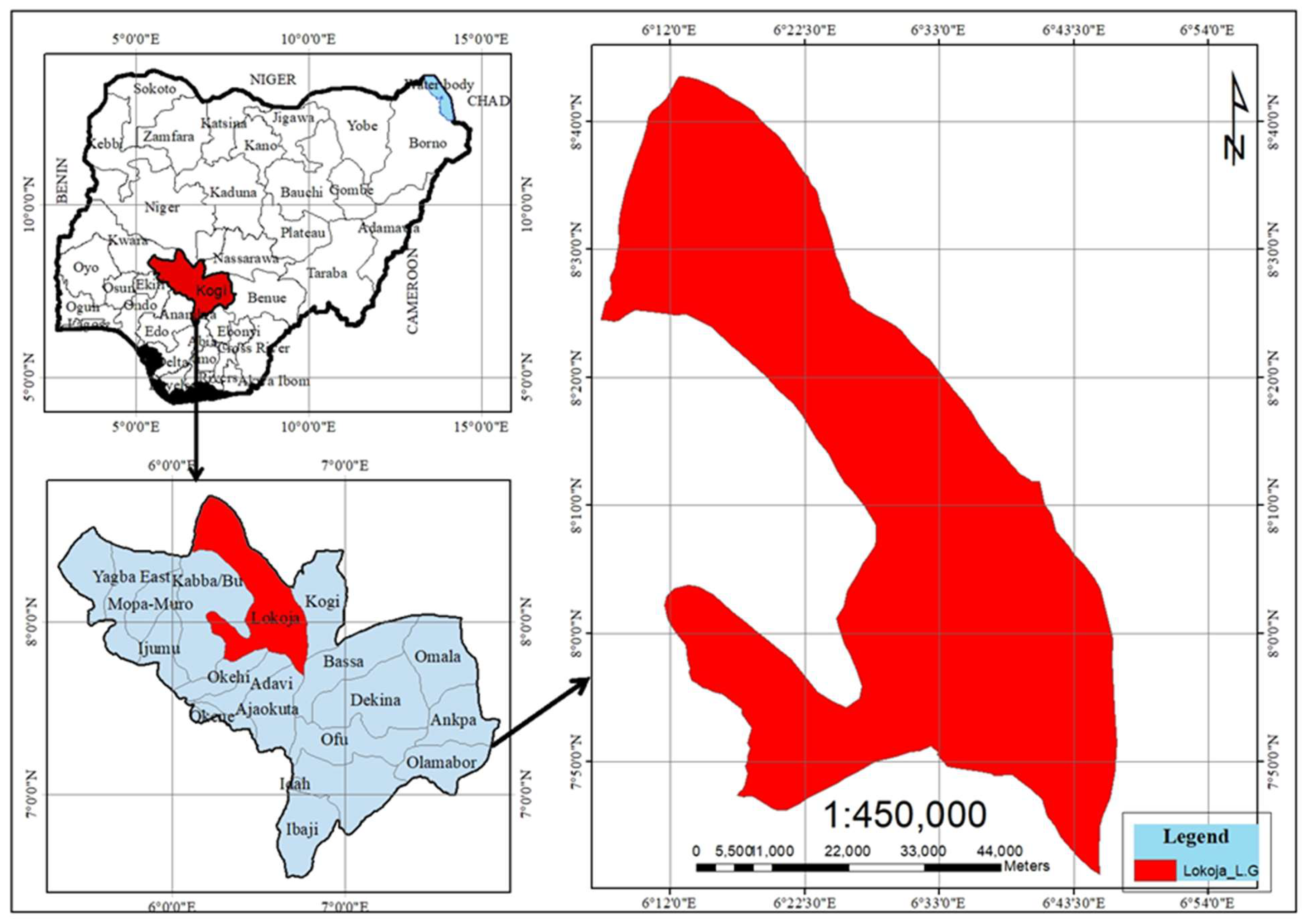
Lokoja, the capital of Kogi State, Nigeria, lies at the confluence of the Niger and Benue Rivers (7°45′–7°52′N, 6°41′–6°45′E). This unique location has shaped its identity as a trade, transport, and administrative hub (Adeoye, 2012; Ifatimehin et al., 2016).
The Lokoja metropolitan area (including the urban core and expanding peri-urban settlements) had an estimated population of approximately 886,000 in 2024, projected to reach 931,000 by 2025 (MacroTrends, 2025; World Population Review, 2025). Lokoja is recognized as one of Africa's (and the world's) fastest-growing cities, with an annual growth rate of 5.6–5.93% during 2020–2025, driven largely by rural-urban migration and its strategic position as a north-south gateway.
Population and urbanization trends are characterized by a high influx from surrounding rural areas and other states, fueled by opportunities in administration, education (e.g., Federal University Lokoja), trade, and transport. This process has driven rapid peri-urban expansion along major transport corridors—particularly the Abuja–Lokoja highway—and across riverine zones, where informal settlements have expanded markedly in areas such as Ganaja, Adankolo, Felele, Lokongoma, and Sarkin Noma. The growth reflects broader Nigerian urbanization patterns—unplanned and low-density expansion—intensifying pressure on flood-prone lowlands, infrastructure, and natural habitats, transforming Lokoja into a dynamic mid-sized metropolitan hub (Avis, 2019; OECD/SWAC et al., 2025).
Ecologically, Lokoja lies within the Guinea savanna zone—a mix of grasslands, scattered trees, and patches of forest. Its landscape includes riparian floodplains, wetlands, and hills such as Mount Patti, which host species like Parkia biglobosa and Vitellaria paradoxa along with diverse bird and aquatic communities (White, 1983). However, these natural ecosystems face increasing pressure from land conversion and urban encroachment. Fanan et al. (2011) assessed biodiversity implications of urban expansion at the Niger–Benue confluence in Lokoja, revealing significant vegetation loss and habitat degradation that threaten ecological connectivity and conservation efforts.
The climate is tropical wet-and-dry (Köppen–Geiger Aw), characterized by a rainy season from April to October (1,200–1,500 mm annual rainfall) and a dry season from November to March, accompanied by harmattan winds (Peel et al., 2007). Mean temperatures range between 25°C and 32°C. Poor drainage and rapid land-use changes contribute to flooding and erosion risks (Oyebande, 1985).
Recent expansion in areas such as Ganaja, Zango, Adankolo, Felele, Lokongoma, and Kabba Junction has transformed green spaces and wetlands into residential and commercial zones, intensifying pressure on sensitive habitats (Adeleke & Oyebande, 2019).
Figure 1.
Map of Lokoja (Source: GIS Laboratory, Federal University, Lokoja. 2025).
3.2. Data Acquisition
This study utilized multi-temporal Landsat imagery (2000, 2010, 2020, and 2024; 30 m resolution) obtained from the USGS Earth Explorer to assess land use and vegetation changes in Lokoja. Dry-season images (December–March) were selected to minimize cloud cover and improve classification accuracy.Additional datasets included:
- Shuttle Radar Topography Mission (SRTM, 30 m) for terrain and floodplain delineation;
- Lokoja LGA shapefiles for administrative boundaries;
- Hansen et al. (2013) Global Forest Change data for cross-validation;
- Field GPS points for ground-truthing of habitat and vegetation types.
3.3. Image Processing and Classification
Landsat imagery from Landsat 7 ETM+, Landsat 8 OLI, and Landsat 9 OLI-2 was processed in Google Earth Engine (GEE). All images were filtered by date and clipped to the Lokoja Local Government Area boundary using the WGS 84 coordinate reference system. Median composites were generated for each study year to reduce cloud contamination, atmospheric noise, and sensor-related inconsistencies, thereby ensuring temporal comparability.
Cloud-affected pixels were minimized using the Landsat simple cloud score algorithm, and all composites were spatially subset to the study area. Spectral indices were derived to enhance land surface discrimination and ecological interpretation. These included the Normalized Difference Vegetation Index (NDVI) to represent vegetation condition, the Normalized Difference Built-up Index (NDBI) to identify built-up surfaces, the Bare Soil Index (BSI) to capture exposed soil and degraded land, and the Normalized Difference Water Index (NDWI) to delineate surface water bodies.
Land use and land cover classification was conducted using a rule-based, index-threshold approach implemented in GEE. Threshold values derived from spectral indices were applied to classify the landscape into seven categories: built-up area, dense forest, woodland, grassland, sparse vegetation, bare soil, and water body. This approach allowed for consistent classification across multiple epochs and facilitated ecological interpretation of land cover dynamics.
The classified maps were subsequently used for spatial analysis and change detection across the study period, providing insights into land cover transitions and landscape dynamics within Lokoja LGA.
3.4. Land Use and Land Cover Change Analysis
Land use and land cover (LULC) change analysis was conducted to evaluate spatial and temporal dynamics in Lokoja Local Government Area between 2000 and 2024. Classified maps generated for the four epochs were used to quantify changes in land cover composition and identify dominant transition patterns over time.
For each study year, the areal extent of the seven land cover classes was calculated in hectares using pixel-based area estimation within Google Earth Engine. Changes in land cover were assessed by comparing class-wise area statistics across epochs, allowing for the identification of increasing, decreasing, or stable land cover categories. This approach enabled a consistent evaluation of long-term landscape dynamics without reliance on post-classification cross-tabulation matrices.
Vegetation dynamics were further examined using mean NDVI values computed for each epoch. Temporal trends in NDVI provided insights into changes in vegetation condition and landscape productivity, complementing the categorical land cover analysis. Increasing or declining NDVI trends were interpreted in relation to observed shifts among dense forest, woodland, grassland, and sparse vegetation classes.
Spatial patterns of change were visually assessed through side-by-side comparison of classified maps for 2000, 2010, 2020, and 2024. This facilitated the identification of areas experiencing urban expansion, vegetation degradation, or recovery. Particular attention was given to transitions involving built-up areas, forested landscapes, and bare surfaces, which are closely linked to population growth, infrastructure development, and land management practices.
The combined use of area statistics, NDVI trends, and spatial map comparison provided a robust basis for understanding land cover change processes and their ecological implications within Lokoja LGA over the 24 years.
3.5. Change Detection and Fragmentation Analysis
Post-classification comparison was used to detect land cover transitions across four intervals (2000–2010, 2010–2020, 2020–2024, and overall 2000–2024). Urban expansion rates were computed as changes in built-up area per year, while habitat loss was derived from conversions of natural to non-natural classes.
Landscape metrics were computed using PyLandStats to quantify habitat fragmentation at class and landscape levels, including:
Percentage of landscape (PLAND), Patch density (PD), Edge density (ED), Largest patch index (LPI), Core area metrics, Landscape shape index (LSI), Shannon’s diversity index (SHDI)
These metrics helped reveal the extent and spatial pattern of fragmentation resulting from urban expansion.
3.6. Vegetation Health and Ecological Assessment
NDVI time-series analysis was performed to evaluate vegetation health trends between 2000 and 2024. Field-based biodiversity observations (plants, birds, and amphibians) were overlaid with land cover maps to assess how habitat loss and fragmentation influenced species distribution and ecosystem quality.
3.7. Data Analysis and Ethical Considerations
Statistical analyses such as Pearson correlation and trend analysis were conducted in R and Python to examine relationships between urban expansion, vegetation health, and habitat loss. All analytical processes were implemented in reproducible open-source workflows (Jupyter notebooks).
Field activities followed ethical standards, including proper data authorization and minimal disturbance to natural habitats during sampling and GPS data collection.
4. Results and Discussion
4.1. Urban Expansion Trajectory: Non-Linear Growth & Consolidation
To address Objective 1, the study mapped and analyzed the spatio-temporal dynamics of Lokoja’s urban expansion between 2000 and 2024. The trajectory reveals a non-linear, three-phase pattern characterized by rapid sprawl, temporary contraction, and subsequent densification.
Figure 2 illustrates the changing land cover structure of Lokoja over the 24-year period. The built-up area expanded sharply from 6,668 ha in 2000 to a peak of 19,371 ha in 2010, then declined to 12,883 ha in 2020 before rising again to 15,985 ha in 2024—a net increase of about 140%. In contrast, dense forest cover nearly disappeared (from 373 ha to 1 ha), while woodland reduced drastically from 2,207 ha to 577 ha. Grassland fluctuated but ultimately expanded to 9,224 ha in 2024, suggesting secondary regeneration. Sparse vegetation decreased to 143 ha, while bare soil reduced from 2,558 ha to 696 ha after 2010, indicating vegetation regrowth on previously cleared land. Water bodies remained relatively stable at about 1,360 ha.
The phases of urban development can be summarized as follows:
- Phase I (2000–2010): Rapid Sprawl. Built-up areas increased by 190% (+1,270 ha/year), forming a centralized urban core along the Niger–Benue confluence and transport corridors. The Largest Patch Index rose to 42%, showing strong urban coalescence.
- Phase II (2010–2020): Peak Dominance and Slowdown. The built-up area declined by 33%, likely due to redevelopment, slum clearance, and the COVID-era economic slowdown. Patch density peaked at 21.8/100 ha, signaling early fragmentation.
- Phase III (2020–2024): Densification and Hyper-Fragmentation. Built-up area rebounded to 15,985 ha (+776 ha/year), but the number of patches increased sharply to 3,887, while mean patch area fell to 2.4 ha, indicating internal densification and reduced green interstices.
Lokoja’s three-phase cycle—sprawl (2000–2010), consolidation (2010–2020), and hyper-fragmentation (2020–2024)—reflects rapid land transformation and ecological strain. Dense forest loss (−99.7%) and a 190% increase in patch count highlight urban pressure on natural systems. Grassland expansion temporarily improved NDVI values (0.22 → 0.32) before a slight decline (0.29 in 2024), indicating short-term greening followed by long-term stress.
Figure 3 presents the mean NDVI trend, showing a gradual improvement in vegetation health until 2020, followed by mild decline under continued urban pressure.
4.2. Spatial Patterns of Expansion
Spatial analysis figure 4 reveals that more than 60% of new built-up areas between 2000 and 2010 occurred within floodplains such as Ganaja, Felele, and Adankolo. Ribbon development was observed along the Abuja–Lokoja highway and the riverbanks, while hillside areas (e.g., Mount Patti) experienced sparse settlement and quarrying.
Edge density increased from 36.2 to 79.9 m/ha (+121%), amplifying environmental challenges such as urban heat island effects, surface runoff, and invasive species spread. Interior green space (>100 m from edge) declined from 4,504 ha (23%) to 3,927 ha (14%), falling below the ecological viability threshold.
Figure 4.
Lokoja, showing the spatial pattern of expansion.
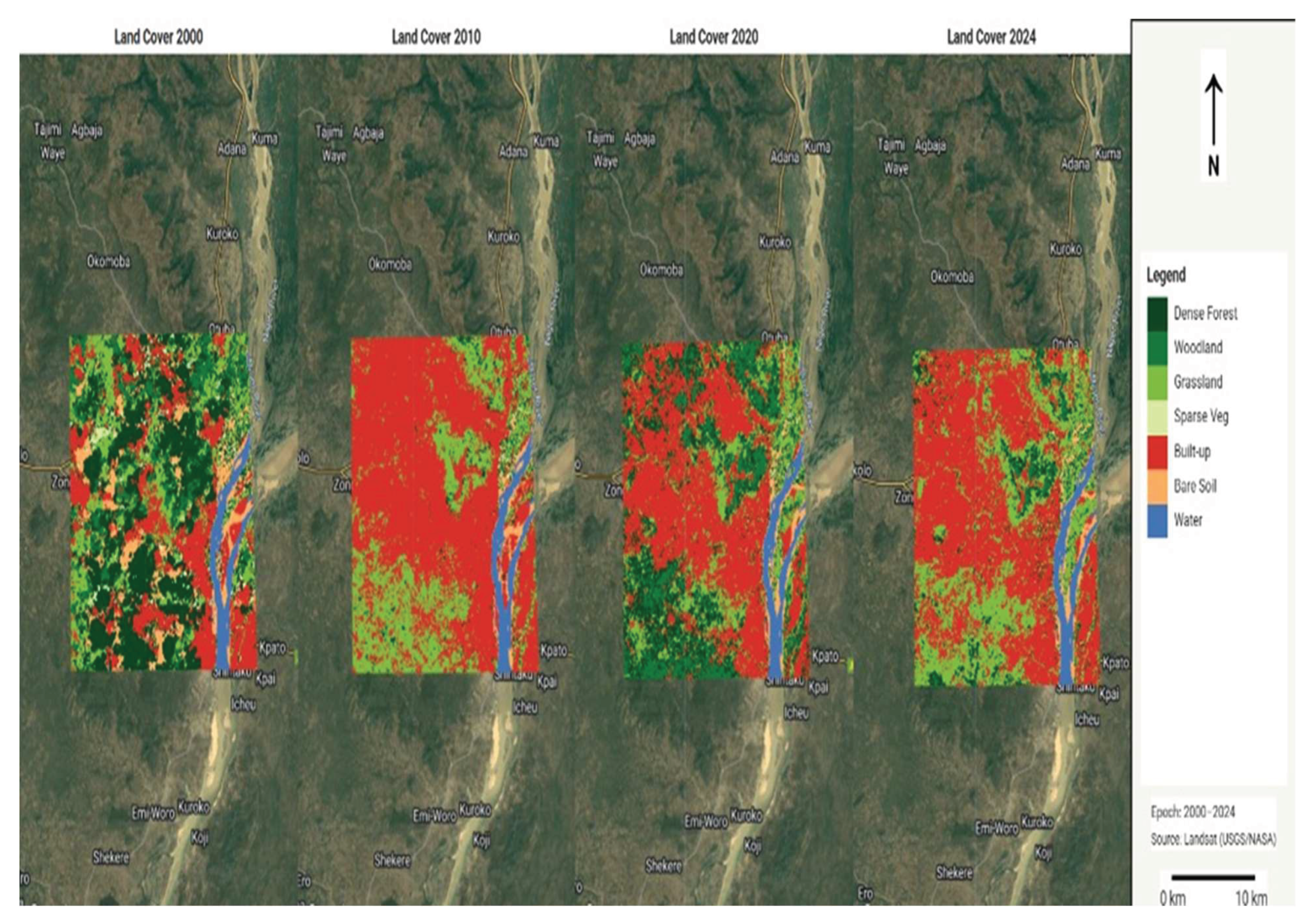
These findings confirm that urban growth in Lokoja is topographically constrained and hydrologically risky, with floodplain encroachment and habitat fragmentation posing major ecological threats.
4.3. Habitat Types and Ecological Roles in Lokoja Metropolis
To address Objective 2, the study identified and characterized major habitat types and their ecological functions. Lokoja’s ecological fabric comprises six major habitat types, each supporting distinct vegetation assemblages and ecosystem services, now increasingly threatened by urban encroachment (Table 1).
Riverine and riparian zones, dominated by gallery forests (e.g., Ficus spp., Syzygium guineense), act as flood buffers, pollutant filters, and wildlife corridors but face intense pressure from residential encroachment and sand mining. Wetlands and floodplains, with reeds (Phragmites spp.) and water lilies, regulate hydrology and support biodiversity yet are increasingly reclaimed for settlement and agriculture.
Savanna woodlands, rich in Vitellaria paradoxa and Parkia biglobosa, provide non-timber products and carbon storage but are being degraded by fuelwood harvesting and quarrying. Grasslands and farmlands stabilize soils and sustain agro-pastoral systems, while rocky outcrops harbor xerophytic shrubs and endemic species threatened by slope modification and mining. Urban green spaces such as roadside trees, institutional gardens, and sacred groves offer microclimate regulation but are often neglected or converted to built-up land.
Overall, these habitats validated through field surveys (2023–2024) form the natural infrastructure of Lokoja, now increasingly fragmented and ecologically weakened by unplanned expansion.
4.4. Quantifying Habitat Loss and Fragmentation Induced by Urban Growth
Addressing Objective 3, the study quantified net habitat loss and fragmentation using Landsat-derived LULC data and FRAGSTATS metrics Table 4.2 and 4.3
Although the total extent of natural habitats in Lokoja Metropolis increased marginally from 8,925 ha in 2000 to 9,946 ha in 2024 (+11.4%), this apparent gain masks severe ecological degradation, as high-quality dense forest and woodland collapsed by 99.7% and 73.9%, respectively, with grassland expansion (+77.1%) reflecting secondary succession on degraded land rather than genuine habitat recovery. Dense forest declined by 99.7%, woodland by 74%, and sparse vegetation by 87%, translating to a net primary vegetation loss of about 3,000 ha (Table 2).
Fragmentation increased markedly across all measured indicators. Edge density more than doubled, rising from 36.2 to 79.9 m/ha (a 121% increase), while patch density nearly doubled from 6.74 to 13.63 patches per 100 ha. Together, these changes point to a landscape becoming increasingly broken and unstable. As habitats are split into smaller, more irregular pieces, edge effects intensify—exposing ecosystems to higher temperatures, increased surface runoff, and greater susceptibility to invasive species.
Over the 24 years we studied, the real “safe zones” for wildlife—the quiet, deep-inside patches of forest and woodland that are far enough from roads and buildings to support shy, edge-sensitive species—shrank dramatically. In 2000, these core areas still covered 4,504 hectares, more than a fifth of Lokoja’s landscape. By 2024, they had fallen to just 3,927 hectares, barely 13.8%. The continued loss of forests and woodland has pushed the city well below the 15–20% habitat threshold identified by ecologists as the minimum required for many forest-dependent birds, mammals, and amphibians to persist over the long term (Andrén, 1994; Fahrig, 2003). The fall from this critical level signals a shift from gradual ecological change to a more precarious state, where species struggle to find sufficient space, food, and breeding sites, increasing the risk of local extinctions.
At the same time, the city’s green fabric has been torn apart. A useful way to picture this is “effective mesh size”—think of it as the average size of the holes left in a net through which animals, seeds, water, and clean air can still move freely. For a brief moment in 2020, during a period of urban consolidation, that value climbed to 4,448 hectares. By 2024, it had crashed to only 557 hectares. In everyday language, the remaining patches of nature are now so small and scattered that wildlife corridors have all but vanished; what is left are isolated green islands surrounded by concrete.
The shape of the surviving patches tells the same story. Back in 2000, the average patch of natural habitat was almost 50 hectares—big enough to feel like a real forest. Today, it is just 2.4 hectares, and the edges have become far more convoluted and jagged. The result is a chaotic, sprawling urban landscape with ever-shrinking interiors and ever-expanding edges, making life harder for nature and, ultimately, for the people of Lokoja who depend on it for flood control, cooler air, and clean water.
Lokoja’s urban trajectory—marked by a 140% built-up increase (6,668 → 15,985 ha) and 99.7% dense forest loss from 2000 to 2024—exceeds typical sub-Saharan African (SSA) mid-sized city patterns, where built-up expansion averages 80–120% over similar periods (Seto et al., 2012; Angel et al., 2021). While Benin City (Enaruvbe & Pontius, 2018) and Accra (Korah et al., 2019) exhibit comparable fragmentation (edge density +60–80 m/ha), Lokoja’s confluence topography and status as Kogi State capital drive ribbon sprawl along the A2 highway and hill-slope encroachment on Mount Patti, amplifying edge density by 121% (36.2 → 79.9 m/ha)—a rate surpassing Jos (Akintunde et al., 2016) and Makurdi (Shabu et al., 2022). This accelerated degradation, compounded by weak land-use governance (UN-Habitat, 2022), positions Lokoja as a critical case for studying ecological tipping points in riverine-administrative urban systems, with implications for climate-adaptive planning across SSA’s secondary cities (Cobbinah & Darkwah, 2016; Taubenböck et al., 2017).
Table 3 presents FRAGSTATS class-level metrics that reveal the evolving spatial structure of Lokoja’s built-up areas from 2000 to 2024, marking a clear transition from cohesive growth to intense fragmentation.
Urban land peaked in 2020 (13,113 ha, 52.7% of the landscape) with a dominant connected core (largest patch index = 42.2%), reflecting coalescence along transport corridors and the river confluence. By 2024, although total urban area decreased to 9,403 ha (33.0%), the number of patches more than doubled (1,719 to 3,887), raising patch density to 13.63 per 100 ha and reducing the largest patch index to 12.4%. This indicates disintegration of the former urban core.
Edge density increased by 121% (36.2 to 79.9 m/ha), expanding urban-nature interfaces and intensifying edge effects such as urban heat islands, accelerated runoff, and ecological stress. Core urban area (>100 m from edges) fell sharply to 3,927 ha (13.8%), while effective mesh size dropped dramatically from 4,448 ha to 557 ha, signalling severe loss of landscape connectivity. The landscape shape index rose to 85.4, confirming increasingly irregular patch shapes typical of ribbon and leapfrog development.
Overall, these metrics demonstrate that recent urban development in Lokoja has shifted to a highly fragmented, edge-dominated pattern, exacerbating pressure on adjacent natural habitats and complicating infrastructure provision, flood control, and sustainable urban management.
5. Conclusion and Recommendations
5.1. Summary of Key Findings
This study investigated the effects of urban expansion on natural habitats in Lokoja Metropolis, Nigeria, over the period 2000–2024. Employing multi-temporal satellite imagery, machine-learning-based land cover classification, landscape metrics, and ground-truthing through fieldwork, the research provides a detailed spatio-temporal analysis of urban growth patterns and their ecological consequences. The city’s expansion followed a non-linear trajectory: rapid outward sprawl from 2000–2010, a period of slower growth and consolidation from 2010–2020, and renewed intensification accompanied by severe fragmentation after 2020. Overall, built-up area increased by 140% (from approximately 6,700 ha to nearly 16,000 ha), while high-quality habitats experienced severe declines—dense forest cover collapsed by 99.7%, woodlands shrank by nearly three-quarters, and an estimated 3,000 ha of primary vegetation were lost. The observed grassland expansion primarily reflects secondary succession on degraded land rather than genuine ecological recovery.
Fragmentation intensified substantially over the study period, with edge density between urban and natural areas increasing by more than 121% (from 36.2 to 79.9 m/ha). Concurrently, the proportion of large, intact core habitats declined from 23% to 13.8% of the total landscape—falling below the 15–20% threshold widely regarded as critical for maintaining long-term viability of many wildlife populations (Andrén, 1994; Fahrig, 2003). Six major habitat types were identified (riverine gallery forests, floodplain wetlands, savanna woodlands, grasslands, rocky outcrops, and urban green spaces), each providing essential ecosystem services such as flood regulation, biodiversity support, and climate moderation, yet all are now severely threatened by encroachment, sand mining, fuelwood extraction, and floodplain reclamation.
These findings underscore Lokoja’s position as a representative case of the ecological pressures confronting mid-sized riverine cities across Africa, where rapid demographic and administrative growth frequently outpaces planning capacity, resulting in elevated flood risks, urban heat stress, biodiversity loss, and diminished ecosystem services.
5.2. Conclusion
Lokoja’s predominantly unplanned urban expansion has inflicted profound and enduring damage on its natural habitats, driving several high-value ecosystems toward functional collapse and undermining the city’s ecological resilience. The near-elimination of dense forest and the intense fragmentation of remaining habitats demonstrate the unsustainability of prevailing development patterns. Absent timely intervention, Lokoja risks irreversible biodiversity decline, exacerbated hydrological vulnerability, and diminished quality of life for its residents.
Nevertheless, evidence of temporary consolidation phases and secondary vegetation regrowth offers grounds for cautious optimism, indicating that targeted measures can reverse adverse trends. By integrating robust remote sensing data with field-validated ecological insights, this study presents a practical, replicable framework for reconciling urban development with habitat conservation in comparable mid-sized African cities.
5.3. Recommendations
To foster sustainable urban development while preserving Lokoja’s remaining natural capital, the following evidence-based measures are proposed:
- Floodplain and riparian protection — Prohibit new development below 10 m elevation and enforce 100-metre buffers along the Niger, Benue, and tributary rivers to preserve natural flood regulation and wildlife corridors.
- Targeted habitat restoration — Prioritise the rehabilitation of at least 500 ha of native riverine gallery forests and savanna woodlands along key corridors, utilising community nurseries and indigenous species to restore ecological connectivity.
- Urban greening mandates — Require a minimum 20% tree canopy cover in all new residential and commercial developments, complemented by incentives for retaining mature trees and establishing green infrastructure (e.g., parks, green roofs, and street plantings).
- Community-led conservation — Formally recognise and protect sacred groves and remnant urban green spaces through community-based monitoring programmes, integrating local knowledge and stewardship into planning processes.
- Strengthened governance — Revise the Lokoja Master Plan to incorporate GIS-based zoning informed by this study’s fragmentation and risk maps, and establish a dedicated inter-agency Urban Ecology Unit to monitor compliance and ecological indicators.
The implementation of these recommendations would not only arrest further habitat degradation but also enhance the city’s resilience to climate-related hazards, improve public health outcomes, and safeguard the cultural and economic values derived from Lokoja’s natural environment. Collectively, these actions—encompassing floodplain protection, riparian restoration, mandatory urban greening, community governance, and institutional reform—directly address the identified patterns of urban expansion, habitat loss, and fragmentation while bolstering ecosystem connectivity and local stewardship. Integrating them into the Lokoja Master Plan would promote sustainable urban growth and secure critical habitats and ecosystem services for present and future generations. The framework presented in this study provides a transferable and replicable model for mid-sized, ecologically sensitive African cities confronting comparable urbanization pressures and environmental vulnerabilities.
Author Contributions
Conceptualization, H.O.J.-N. and R.O.J.; Methodology, H.O.J.-N. and N.I.N.; Software, N.I.N. and N.G.J.; Validation, E.M., N.G.J. and O.R.O.; Formal analysis, N.I.N.; Investigation, N.I.N. and R.O.J.; Resources, R.O.J.; Data curation, H.O.J.-N. and N.I.N.; Writing—original draft preparation, R.O.J.; Writing—review and editing, H.O.J.-N. and E.M.; Visualization, N.I.N. and R.O.J.; Supervision, H.O.J.-N., N.G.J. and O.R.O.; Project administration, E.M., N.G.J. and O.R.O.; Funding acquisition, E.M., N.G.J. and O.R.O. All authors have read and agreed to the published version of the manuscript.
Funding
This research received no external funding.
Conflicts of Interest
The authors declare no conflict of interest.
References
- Adegun, O. B. Informal urban expansion and the environment in Nigeria: Insights from Ogbomosho. Urban Forum 2021, 32(4), 495–512. [Google Scholar] [CrossRef]
- Aderamo, A. J. Urbanization and transportation development in Nigeria. Journal of Geography and Regional Planning 2008, 1(1), 001–009. Available online: https://academicjournals.org/journal/JGRP/article-full-text-pdf/9F7E5A56789.
- Adelekan, I. O. Flood risk management in the coastal city of Lagos, Nigeria. Journal of Flood Risk Management 2016, 9(3), 255–264. [Google Scholar] [CrossRef]
- Adeleke, B. O.; Oyebande, L. Urban dynamics, everyday hazards, and disaster risks in Ibadan, Nigeria. Environment and Urbanization 2019, 31(2), 451–468. [Google Scholar] [CrossRef]
- Adeoye, N. O. Spatio-temporal analysis of land use/cover change of Lokoja—a confluence town. Journal of Geography and Geology 2012, 4(4), 40–51. [Google Scholar] [CrossRef]
- Agbefe, L. E.; Oluwatobi, A. O.; Oshodi, O. O. Implications of urban expansion: Land, planning and housing in Lagos. Buildings & Cities 2022, 3(1), 1–16. [Google Scholar]
- Akintunde, J. A.; Ojo, O. B.; Afolabi, Y. D. Urban expansion and loss of agricultural land in Jos Metropolis, Nigeria. Journal of Environmental Management and Tourism 2016, 7(2), 258–269. [Google Scholar]
- Akubia, J. E. K.; Bruns, A. Unravelling the frontiers of urban growth: Spatio-temporal dynamics of land-use change and urban expansion in Greater Accra Metropolitan Area, Ghana. Land 2019, 8(9), 131. [Google Scholar] [CrossRef]
- Alabi, M. O. Urban sprawl, pattern, and measurement in Lokoja, Nigeria. Theoretical and Empirical Research in Urban Management 2009, 4(13), 158–164. [Google Scholar]
- Aliyu, Y. A.; Youngu, T. T.; Abubakar, A. Z.; Bala, A.; Jesulowo, C. I. Monitoring and forecasting spatio-temporal LULC for Akure rainforest habitat in Nigeria. Reports in Geodesy and Geoinformatics 2020, 110(1), 29–38. [Google Scholar] [CrossRef]
- Allu-Kangkum, E. L. A.; Umar, S. D. Community-engaged architecture and flooding resilience for Lokoja, Nigeria. BIMA Journal of Science and Technology 2025, 9(1B), 25–33. [Google Scholar]
- Allen, A.; Lu, K. Governance of land use in African cities. Habitat International 2003, 27(3), 389–407. [Google Scholar] [CrossRef]
- Amoako, C.; Frimpong Boamah, E. The three-phase evolution of Ghana’s urban system. Urban Studies 2015, 52(2), 384–401. [Google Scholar] [CrossRef]
- Andrén, H. Effects of habitat fragmentation on birds and mammals in landscapes with different proportions of suitable habitat: A review. Oikos 1994, 71(3), 355–366. [Google Scholar] [CrossRef]
- Angel, S.; Parent, J.; Civco, D. L.; Blei, A.; Potere, D. The dimensions of global urban expansion: Estimates and projections for all countries, 2000–2050. Proceedings of the National Academy of Sciences 2021, 118(51), e2022202118. [Google Scholar] [CrossRef]
- Anthony, T. Spatial analysis of land cover changes for detecting environmental degradation in Abeokuta South, Nigeria. Environmental Monitoring and Remote Sensing Studies 2024, 1(1), 12–29. [Google Scholar]
- Aribisala, J. O.; Adebayo, A. A.; Ojo, O. B. Sacred groves as biodiversity hotspots in urbanizing Nigerian landscapes: A case study of Osun-Osogbo and implications for conservation. African Journal of Ecology 2021, 59(3), 678–689. [Google Scholar] [CrossRef]
- Avis, W. R. Urban expansion in Nigeria (Rapid literature review). In Institute of Development Studies / GSDRC; 2019; Available online: https://gsdrc.org/wp-content/uploads/2019/11/692_Urban_Expansion_of_Nigerian_Cities.pdf.
- Bolund, P.; Hunhammar, S. Ecosystem services in urban areas. Ecological Economics 1999, 29(2), 293–301. [Google Scholar] [CrossRef]
- Chapin, F. S., III; Zavaleta, E. S.; Eviner, V. T.; Naylor, R. L.; Vitousek, P. M.; Reynolds, H. L.; Hooper, D. U.; Lavorel, S.; Sala, O. E.; Hobbie, S. E.; Mack, M. C.; Díaz, S. Consequences of changing biodiversity. Nature 2000, 405(6783), 234–242. [Google Scholar] [CrossRef]
- Cobbinah, P. B.; Darkwah, R. M. Urban planning and the challenges of informal settlements in Ghana. GeoJournal 2016, 81(3), 409–423. [Google Scholar] [CrossRef]
- Urbanization, biodiversity, and ecosystem services: Challenges and opportunities; Elmqvist, T., Fragkias, M., Goodness, J., Güneralp, B., Marcotullio, P. J., McDonald, R. I., Parnell, S., Schewenius, M., Sendstad, M., Seto, K. C., Wilkinson, C., Eds.; Springer, 2013. [Google Scholar] [CrossRef]
- Enaruvbe, G. O.; Pontius, R. G., Jr. Landscape fragmentation and urban expansion in Benin City, Nigeria: A remote sensing and GIS approach. Journal of Environmental Management 2018, 221, 1–12. [Google Scholar] [CrossRef]
- Fabolude, G. O.; David, O. A.; Akanmu, A. O.; Nakalembe, C.; Komolafe, R. J.; Adekunle, A. A. Impacts of anthropogenic disturbance on forest vegetation cover, health, and diversity within Doma forest reserve, Nigeria. Environmental Monitoring and Assessment 2023, 195(11), 1270. [Google Scholar] [CrossRef]
- Fahrig, L. Effects of habitat fragmentation on biodiversity. Annual Review of Ecology, Evolution, and Systematics 2003, 34(1), 487–515. [Google Scholar] [CrossRef]
- Fanan, U.; Ifatimehin, O. O.; Musa, S. D. An analysis of urban expansion and loss of vegetation cover in Lokoja, Nigeria, using GIS techniques. Zaria Geographer 2011, 17(1), 28–36. [Google Scholar]
- Forman, R. T. T. Land mosaics: The ecology of landscapes and regions; Cambridge University Press, 1995. [Google Scholar]
- Garba, S. I.; Obiefuna, J. N.; Lawal, K. M.; Musa, A. M. Wetland mapping at 10 m resolution reveals fragmentation and spatial patterns in southern Nigeria. In Wetlands Ecology and Management.; 2023. [Google Scholar] [CrossRef]
- Gilbert, K. M.; Shi, Y. S. Land use/land cover changes detection in Lagos City of Nigeria using remote sensing and GIS. Advances in Remote Sensing 2023, 12, 145–165. [Google Scholar] [CrossRef]
- Grimm, N. B.; Faeth, S. H.; Golubiewski, N. E.; Redman, C. L.; Wu, J.; Bai, X.; Briggs, J. M. Global change and the ecology of cities. Science 2008, 319(5864), 756–760. [Google Scholar] [CrossRef]
- Ifatimehin, O. O.; Ufuah, M. E. An analysis of urban expansion and loss of vegetation cover in Lokoja using GIS techniques. Zaria Geographer 2006, 17(1), 28–36. [Google Scholar]
- Ifatimehin, O. O.; Ufuah, M. E.; Orighomisan, I. E. Impacts of rapid urbanisation in the urban fringe of Lokoja, Nigeria. Journal of Geography and Regional Planning 2016, 9(10), 185–194. [Google Scholar] [CrossRef]
- Iortyom, E. T.; Semaka, J. T.; Abawua, J. I. Spatial expansion of urban activities and agricultural lands encroachment in Makurdi Metropolis, Benue State, Nigeria (1999–2012). European Journal of Environment and Earth Sciences 2020, 1(5), 25–33. [Google Scholar] [CrossRef]
- The compact city: A sustainable urban form? In E & FN Spon; Jenks, M., Burton, E., Williams, K., Eds.; 1996. [Google Scholar]
- Kabisch, N.; Qureshi, S.; Haase, D. Human–environment interactions in urban green spaces—A systematic review of contemporary issues and prospects for future research. Environmental Impact Assessment Review 2015, 50, 25–34. [Google Scholar] [CrossRef]
- Koko, A. F.; Yue, W.; Abubakar, G. A.; Hamed, R.; Alabsi, A. A. N. Analyzing urban growth and land cover change scenario in Lagos, Nigeria, using multi-temporal remote sensing data and GIS to mitigate flooding. Geomatics, Natural Hazards and Risk 2021, 12(1), 631–652. [Google Scholar] [CrossRef]
- Korah, A. I.; Koch, J. A. M.; Wimberly, M. C. Understanding urban growth modeling in Africa: A review. Landscape and Urban Planning 2024, 245, 105012. [Google Scholar] [CrossRef]
- Korah, A. I.; Matthews, T.; Tomerini, D. Characterising spatial and temporal patterns of urban growth in Ghana: A tale of two cities. Applied Geography 2019, 112, 102100. [Google Scholar] [CrossRef]
- MacroTrends. Lokoja, Nigeria metro area population 1950–2025. n.d. Available online: https://www.macrotrends.net/global-metrics/cities/206383/lokoja/population.
- McDonald, R. I.; Marcotullio, P. J.; Güneralp, B. Urbanization and global trends in biodiversity and ecosystem services. In Urbanization, biodiversity and ecosystem services: Challenges and opportunities; Elmqvist, T., Fragkias, M., Goodness, J., Güneralp, B., Marcotullio, P. J., McDonald, R. I., Parnell, S., Schewenius, M., Sendstad, M., Seto, K. C., Wilkinson, C., Eds.; Springer, 2013; pp. 31–52. [Google Scholar] [CrossRef]
- McDonnell, M. J.; Hahs, A. K. The use of gradient analysis studies in advancing our understanding of the ecology of urbanizing landscapes. Landscape Ecology 2008, 23, 1143–1155. [Google Scholar] [CrossRef]
- McDonnell, M. J.; Pickett, S. T. A. Ecosystem structure and function along urban–rural gradients: An unexploited opportunity for ecology. Ecology 1990, 71(4), 1232–1237. [Google Scholar] [CrossRef]
- Mensah, C.; Owusu, K.; Ameyaw, B. Urban expansion and wetland loss in Accra, Ghana: A remote sensing assessment. Urban Forestry & Urban Greening 2020, 49, Article 126600. [Google Scholar] [CrossRef]
- National Planning Commission. National Development Plan (2021-2025). 2021; Volume 1. Available online: https://nigeriareposit.nln.gov.ng/items/1e1972a6-84c2-4465-949d-7ce24834e0b2.
- National Population Commission. 2006 population and housing census. Federal Republic of Nigeria; 2006. [Google Scholar]
- Odaudu, U. S. Impact of urbanisation on the housing rent in the Lokoja metropolis, Kogi State, Nigeria. International Journal of Science and Advanced Innovative Research 2019, 3(1), 15–24. Available online: https://casirmediapublishing.com/wp-content/uploads/2019/09/pages-15-24-18-3001.pdf.
- Ogunbode, C. A.; Player, L.; Lu, S.; Park, M. S. A.; Doran, R. Climate anxiety in perspective: A look at dominant stressors in youth mental health and sleep. In Annals of the New York Academy of Sciences; Advance online publication, 2025. [Google Scholar] [CrossRef]
- Omodehin, A. O.; Basorun, J. O.; Oyinloye, M. A. Spatial changes in wetland configuration of Akure South Local Government Area of Ondo State, Nigeria. Urban and Regional Planning 2021, 6(3), 76–81. [Google Scholar] [CrossRef]
- Organisation for Economic Co-operation and Development/Sahel and West Africa Club. Africa's urbanisation dynamics 2025: Planning for urban expansion; OECD Publishing, 2025. [Google Scholar]
- Onyekwelu, J. C.; Olusola, J. A. Role of sacred grove in in-situ biodiversity conservation in rainforest zone of south-western Nigeria. Journal of Tropical Forest Science 2014, 26(4), 449–460. Available online: https://www.jstor.org/stable/43093124.
- Oyinloye, M. A.; Kufoniyi, O. Analysis of land use/landcover change and urban expansion in Akure, Nigeria. Journal of Innovative Research in Engineering and Sciences 2011, 2(4), 180–189. [Google Scholar]
- Oyinloye, M. A.; Kufoniyi, O. Analysis of land cover change detection and urban expansion in Akure, Nigeria, using remote sensing and GIS techniques. Journal of Environment and Earth Science 2013, 3(4), 1–10. [Google Scholar]
- Peel, M. C.; Finlayson, B. L.; McMahon, T. A. Updated world map of the Köppen-Geiger climate classification. Hydrology and Earth System Sciences 2007, 11(5), 1633–1644. [Google Scholar] [CrossRef]
- Seto, K. C.; Güneralp, B.; Hutyra, L. R. Global forecasts of urban expansion to 2030 and direct impacts on biodiversity and carbon pools. Proceedings of the National Academy of Sciences 2012, 109(40), 16083–16088. [Google Scholar] [CrossRef]
- Shabu, T.; Fate, T.; Ukula, J. Impact of urbanization on agricultural land in Makurdi Local Government Area, Benue State, Nigeria. African Geographical Review 2022, 41(2), 150–165. [Google Scholar] [CrossRef]
- Taubenböck, H.; Weigand, M.; Esch, T.; Staab, J.; Klotz, M. A new dimension in urban remote sensing: Global urban footprints from space. Remote Sensing of Environment 2017, 199, 225–239. [Google Scholar] [CrossRef]
- Theobald, D. M. Land-use dynamics beyond the American urban fringe. Geographical Review 2001, 91(3), 544–564. [Google Scholar] [CrossRef]
- Tijani, M. N.; Olaleye, A. O.; Olubanjo, O. O. Impact of urbanization on wetland degradation: A case study of Eleyele Wetland, Ibadan, South-West Nigeria. COLERM Proceedings, 2012; Federal University of Agriculture. [Google Scholar]
- Turner, B. L.; Meyer, W. B.; Skole, D. L. Global land-use/land-cover change: Towards an integrated study. Ambio 1994, 23(1), 91–95. [Google Scholar]
- Ujoh, F.; Akinluyi, F. O. An evaluation of the effect of land use/cover change on the surface temperature of Lokoja town, Nigeria. African Journal of Environmental Science and Technology 2009, 3(3), 86–90. [Google Scholar] [CrossRef]
- Ukoje, J. E. Impacts of rapid urbanisation in the urban fringe of Lokoja, Nigeria. Journal of Geography and Regional Planning 2016, 9(8), 206–214. [Google Scholar] [CrossRef]
- United Nations; Department of Economic and Social Affairs. World urbanization prospects: The 2023 revision. 2023. Available online: https://population.un.org/wup.
- United Nations; Department of Economic and Social Affairs; Population Division. World urbanization prospects: The 2018 revision (ST/ESA/SER.A/420). 2018. Available online: https://population.un.org/wup/Publications/.
- United Nations Human Settlements Programme (UN-Habitat). World Cities Report 2016: Urbanization and Development – Emerging Futures; 2016. [Google Scholar]
- United Nations Human Settlements Programme (UN-Habitat). Climate resilience and urban development in Africa. 2022. Available online: https://unhabitat.org.
- United Nations Human Settlements Programme (UN-Habitat). World Cities Report 2022: Envisaging the future of cities; Author, 2023. [Google Scholar]
- White, F. The vegetation of Africa: A descriptive memoir to accompany the UNESCO/AETFAT/UNSO vegetation map of Africa; UNESCO, 1983. [Google Scholar]
- Wizor, C. H.; Wali, E. Geo-spatial analysis of urban wetland loss in Obio/Akpor Local Government Area, Rivers State, Nigeria. Asian Journal of Geographical Research 2020, 3(1), 15–26. [Google Scholar] [CrossRef]
- World Bank. Urban development in Sub-Saharan Africa: An overview; World Bank Publications, 2020. [Google Scholar]
- World Bank. Africa urbanization review: Lagos and corridors; World Bank Publications, 2021. [Google Scholar]
- World Bank. Nigeria: Urbanization profile and housing finance; World Bank Publications, 2022. [Google Scholar]
- World Bank. Nigeria—Lagos urban development and governance; World Bank Publications, 2023. [Google Scholar]
- World Bank. Climate risk and resilience in Nigerian cities; World Bank Publications, 2024. [Google Scholar]
- World Population Review. Lokoja population 2025. n.d. Available online: https://worldpopulationreview.com/cities/nigeria/lokoja.
Figure 2.
Land Cover Change (2000-2024).
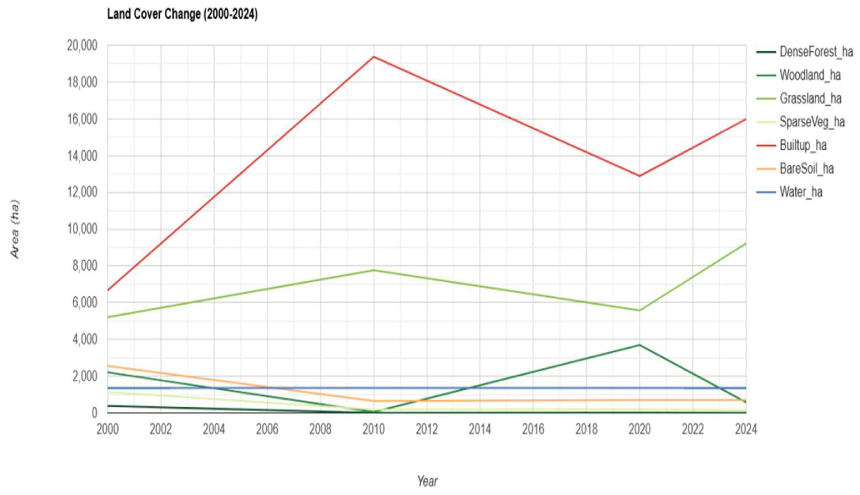
Figure 3.
Mean NDVI Trend (2000-2024).
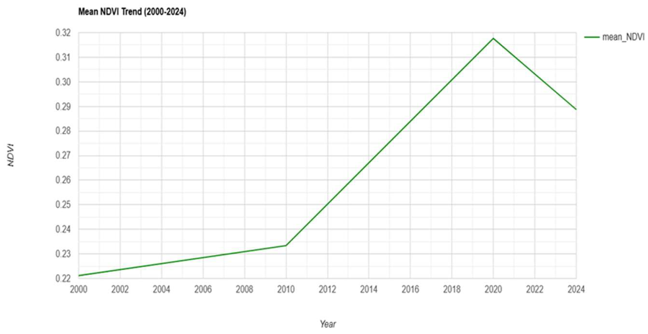

Table 1.
Habitat Types, Dominant Vegetation, and Primary Urban Threats in Lokoja Metropolis, Nigeria.
Table 1.
Habitat Types, Dominant Vegetation, and Primary Urban Threats in Lokoja Metropolis, Nigeria.
| Habitat Type | Dominant Vegetation | Major Threat from Urban Expansion | Source(s) |
| Riverine & Riparian Zones | Gallery forests (Ficus spp., Syzygium guineense), raffia palm (Raphia hookeri), aquatic grasses (Echinochloa pyramidalis, Vossia cuspidata) | Residential encroachment, sand mining, surface runoff pollution, riverbank destabilization | Ifatimehin et al. (2016); Ujoh & Akinluyi (2009); Adeoye (2012). |
| Wetlands & Floodplains | Reeds (Phragmites australis), sedges (Cyperus papyrus), water lilies (Nymphaea lotus), floating grasses | Land reclamation for housing, floodplain agriculture, solid waste dumping, altered hydrology | Wizor & Wali (2020); Adeoye (2012); Field surveys (2023–2024). |
| Savanna Woodland | Vitellaria paradoxa (shea), Parkia biglobosa (locust bean), Isoberlinia doka, Daniellia oliveri, Detarium microcarpum | Deforestation for fuelwood/charcoal, road infrastructure, seasonal bush burning, and quarrying | Aribisala et al. (2021); Fanan et al. (2011); Ifatimehin (2016); Field surveys (2023–2024). |
| Grassland & Farmlands | Secondary grasses (Andropogon gayanus, Hyparrhenia rufa), shrubs, staple crops (yam, cassava, maize) | Settlement sprawl, intensive cultivation, soil compaction, agrochemical runoff | Shabu et al. (2022); Ifatimehin et al. (2016) |
| Rocky Outcrops & Hill Habitats | Sparse xerophytic shrubs (Euphorbia kamerunica, Combretum collinum), lichens, grasses; Mount Patti vegetation | Granite quarrying, slope modification for construction/tourism, gully erosion | Fanan et al. (2011); Adeoye (2012); Field observation (2024) |
| Urban Green Spaces (modified habitats) | Roadside trees (Azadirachta indica, Delonix regia), institutional gardens, sacred groves, remnant patches | Conversion to built-up land, neglect of urban forestry, air/noise pollution | Aribisala et al. (2021); National Planning Commission (2021) |
Table 2.
Natural Habitat.
| Year | Bare Soil (ha) | Built-up (ha) | Dense Forest (ha) | Grassland (ha) | Sparse Vegetation (ha) | Water (ha) | Woodland (ha) | Mean NDVI |
| 2000 | 2,558.03 | 6,667.73 | 373.67 | 5,207.43 | 1,137.48 | 1,359.69 | 2,206.82 | 0.2211 |
| 2010 | 653.58 | 19,371.04 | 0.00 | 7,763.75 | 188.96 | 1,359.69 | 52.35 | 0.2334 |
| 2020 | 691.71 | 12,883.33 | 15.42 | 5,571.02 | 198.03 | 1,359.69 | 3,689.84 | 0.3177 |
| 2024 | 695.97 | 15,984.61 | 1.24 | 9,224.46 | 143.32 | 1,359.69 | 576.91 | 0.2887 |
Table 3.
FRAGSTATS class-level metrics for the dominant urban land cover class in Lokoja, Nigeria (2000-2024).
Table 3.
FRAGSTATS class-level metrics for the dominant urban land cover class in Lokoja, Nigeria (2000-2024).
| Year | total area (ha) | proportion of landscape (%) | number of patches | patch density (/100 ha) | largest patch index (%) | edge density (m/ha) | total core area (ha) | core area proportion of landscape (%) | landscape shape index | effective mesh size (ha) |
| 2000 | 6793.56 | 34.15 | 1340 | 6.74 | 7.21 | 36.19 | 4503.69 | 22.64 | 38.68 | 167.68 |
| 2010 | 7920.63 | 26.45 | 2041 | 6.81 | 12.79 | 57.12 | 3994.65 | 13.34 | 61.32 | 559.88 |
| 2020 | 13,113.18 | 52.72 | 1719 | 6.91 | 42.23 | 58.18 | 8826.48 | 35.49 | 49.52 | 4448.44 |
| 2024 | 9403.29 | 32.98 | 3887 | 13.63 | 12.40 | 79.91 | 3926.61 | 13.77 | 85.39 | 557.44 |
Disclaimer/Publisher’s Note: The statements, opinions and data contained in all publications are solely those of the individual author(s) and contributor(s) and not of MDPI and/or the editor(s). MDPI and/or the editor(s) disclaim responsibility for any injury to people or property resulting from any ideas, methods, instructions or products referred to in the content. |
© 2026 by the authors. Licensee MDPI, Basel, Switzerland. This article is an open access article distributed under the terms and conditions of the Creative Commons Attribution (CC BY) license (http://creativecommons.org/licenses/by/4.0/).
Copyright: This open access article is published under a Creative Commons CC BY 4.0 license, which permit the free download, distribution, and reuse, provided that the author and preprint are cited in any reuse.


