
Submitted:
07 June 2024
Posted:
11 June 2024
You are already at the latest version
Abstract
This study investigates the spatial urban growth patterns of cities along the Democratic Republic of Congo (DRC) and Zambia border, a region of significant economic importance characterized by cross-border trade. This activity has led to rapid, but unplanned urban growth. The objective is to quantify the spatial expansion of Congolese cities (Kipushi, Kasumbalesa, Mokambo, and Sakania) bordering Zambia and to evaluate associated landscape changes. The methodology integrates Landsat images from 1990, 2000, 2010, and 2023, coupled with Geographic Information Systems (GIS) and landscape ecology analysis tools. The results reveal substantial landscape transformations in the border cities between 1990 and 2023. These changes are primarily driven by rapid urban expansion, particularly pronounced in Kasumbalesa. Between 1990 and 2023, forest cover declined from 70% to less than 15% in Kipushi, from 80% to 10% in Kasumbalesa, from 90% to 30% in Mokambo, and from 80% to 15% in Sakania. This forest cover loss is accompanied by an increase in landscape element diversity, as indicated by the Shannon diversity index, except in Kipushi, suggesting a transition towards more heterogeneous landscapes. In these border cities, landscape dynamics are also characterized by the expansion of agriculture and savannas, highlighted by an increase in the disturbance index. Spatial pattern changes analysis shows that built-up areas, agriculture, and savannas exhibit trends of patch creation or aggregation, while forests are undergoing processes of dissection and patch attrition. Congolese cities bordering Zambia are undergoing substantial spatial changes propelled by intricate interactions between economic, demographic, and infrastructural factors. Our results highlight the necessity for sustainable development strategies to address challenges such as urban sprawl, deforestation, and fostering cross-border cooperation in border regions.
Keywords:
Spatial growth patterns
; Urban sprawl
; Deforestation
; Remote sensing
; Sustainable development strategies
1. Introduction
Global urbanization is a multifaceted process influenced by demographic, economic, and social factors [1]. By 2018, over half of the world's population resided in urban areas, a figure projected to reach 68% by 2050 [2]. Urbanization rates vary globally, with rapid acceleration observed in developing regions such as Africa, fueled by migration and population growth [3]. While Africa remains predominantly rural, it is expected to undergo significant urbanization by 2050 [4,5], with countries like Nigeria, the Democratic Republic of the Congo (DR Congo), Ethiopia, and Tanzania projected to contribute significantly to this global urban population increase by 2050 [6,7].
Rapid urbanization in Africa induces profound changes in urban landscapes [8] and presents challenges such as housing shortages and infrastructure strain, underscoring the need for effective urban planning and governance [9]. This is particularly crucial in small and medium-sized border cities, necessitating tailored policies for sustainable development [10]. These cities, often rife with uncertainties and complexities, concentrate extreme poverty, particularly among those with limited options [11,12]. Located strategically near national borders, they experience rapid population growth due to cross-border activities and economic potential, requiring careful consideration and strategic interventions [13]. The unplanned expansion of border cities presents significant urban planning challenges, surpassing local authorities' planning capacity, leading to unsustainable urban sprawl affecting land use, infrastructure, and the environment [14].
In Central-Southern Africa, the Katangese Copperbelt Area (KCA), situated in southeastern DR Congo bordering Zambia, exemplifies this trend. Cities in this area reflect shared histories and cultural exchanges driven by mining activities and trade. Proximity to national borders transforms these cities into dynamic economic hubs fostering cross-border trade and investment [15,16]. Migration, primarily motivated by employment opportunities, significantly contributes to rapid urbanization and demographic growth, intensifying the demand for housing and infrastructure [17,18]. Efficient transport infrastructure plays a crucial role in supporting commercial activities and regional connectivity, while industrial policies influence growth through the establishment of industries and economic zones, driving urban expansion and economic development [19,20]. However, these cities face urban planning and governance challenges, leading to rapid, unregulated urbanization resulting in a lack of green spaces, and inadequate infrastructure and services [21]. This issue is particularly acute in the DR Congo due to rapid population growth, poor governance, and widespread poverty.
Congolese border cities like Kipushi, Kasumbalesa, Mokambo, and Sakania confront notable challenges concerning urban development and governance, notably housing provision. Mining activities historically shaped Sakania and Kipushi, attracting workers from the city of Lubumbashi (the provincial capital) and beyond post-2002 mining sector liberalization [22,23]. Kipushi developed residential areas for Congolese army personnel, while Kasumbalesa, pivotal for cross-border exchanges, expanded without planning due to recent demographic explosions. Mokambo's growth stems from the road network and a border post, fostering economic opportunities. These agglomerations expand spatially but face largely unplanned, informal urbanization, marked by land use conflicts [24,25]. Social ghettos exacerbated social disparities, and visual landscape degradation lead to biodiversity loss, as evidenced in the city of Lubumbashi, where 3.6 km² of green space is lost annually [26]. Yet, urban trees, green belts, and peri-urban forests are essential for sustainable development.
Systematic mapping and quantitative assessment of spatial dynamics in Congolese border cities are essential for understanding urban development implications. Remote sensing and landscape ecology techniques offer a robust framework for monitoring spatio-temporal landscape changes [27,28]. Additionally, landscape ecology explores landscape structure and ecosystem interactions [29]. The synergy between these approaches fosters a comprehensive understanding of border urbanization and associated landscape dynamics, facilitating evidence-based policies for sustainable growth and resource management [30].
The objective of this study is to conduct an in-depth spatial analysis of border urban dynamics and associated landscape changes, between the DR Congo and Zambia. The hypothesis being tested is that due to rapid population growth and economic opportunities, border towns are experiencing accelerated urban expansion, particularly in medium-sized cities with dynamic economies. This disrupts landscapes by increasing heterogeneity and promotes the expansion of savannas due to forest fragmentation.
2. Materials and Methods
2.1. Study Area: Congolese Cities Bordering Zambia
The cities of Kipushi, Kasumbalesa, Mokambo, and Sakania are strategically located in the southeastern region of the DR Congo (Figure 1), within the Katangese Copperbelt Area (KCA) [31].
Situated between 10° and 12° S and 26° and 29° E, this region falls under the Cw climate classification, characterized by a distinct rainy season from November to March and a dry season from May to September, with transitional months in April and October [32]. The region receives an annual precipitation of approximately 1200 mm and has an average annual temperature of 20 °C [32]. The topography is predominantly flat with scattered hills typical of the Katanga landscape, and the soils are primarily ferralsol-type [33]. Rapid urbanization and human activities have fragmented the original miombo woodland, transitioning it into savannahs [34-36]. These cities are experiencing continuous population growth, with estimates of 396,000 in Kipushi, 700,000 in Kasumbalesa, 47,000 in Mokambo, and 55,000 in Sakania [37]. Economic activities in this region are diverse, focusing on mining, agriculture, and cross-border trade, particularly significant due to proximity to the Zambian border. Trade between the DR Congo and Zambia is dominated by the exchange of minerals, especially copper and cobalt. The DR Congo mainly exports these minerals to Zambia, while Zambia provides the DR Congo with manufactured and agricultural products, which transit through these border cities. Kasumbalesa serves as a major border city with established customs infrastructure; Mokambo features a dry port and critical road connections; Sakania is influenced by its mining history and industrial potential, while Kipushi is recognized for its mining legacy and ongoing urban revitalization efforts.
2.2. Methodology
2.2.1. Data
Landsat images with a 30-meter spatial resolution and less than 5% cloud cover, spanning from 1990 to 2023, were utilized for this study. The selected intervals (1990-2000, 2000-2010, and 2010-2023) enable a decadal analysis, capturing long-term trends and spatial dynamics changes. The 1990-2000 period was characterized by political turbulence and conflicts in the Eastern region. The 2000-2010 era witnessed mining sector liberalization (2002), the first electoral cycle (2006), subsequent infrastructure modernization, and the global financial crisis (2008). The 2010-2023 period saw additional electoral cycles (2011 and 2018), provincial restructuring (2015), and a change in political regime (2019). The selection of Landsat images specifically during the dry season minimizes cloud cover, ensuring clear visibility for accurate interpretation of landscape features [23]. This approach is crucial for precise mapping and quantification of spatio-temporal landscape changes [38].
2.2.2. Classification
Using the WGS-84 reference ellipsoid, the Landsat images were georeferenced in the UTM Zone 35S coordinate system, which corresponds to the study region [23]. Additionally, radiometric normalization was applied to minimize reflectance variations between Landsat image dates. Global corrections for atmospheric effects were also performed using the dark object subtraction method [39]. Consecutively, a false-color composite of selected Landsat images was meticulously constructed by combining the mid-infrared, near-infrared, and red bands, to enhance discrimination among diverse vegetation types [40,41]. For precision and clarity, distinctive land cover units were methodically identified and assigned unique codes across different scenes. To establish a solid foundation for subsequent analyses, Regions of Interest (ROIs), representing training areas, were meticulously delineated for each study year, during the dry season. The selection of ROIs was guided by sampling polygons, strategically positioned to avoid transition zones, thereby minimizing the impact of the mixel phenomenon, and enhancing subsequent analysis accuracy [42,43]. To refine analytical capabilities, these carefully crafted ROIs were utilized to construct a comprehensive model for training the Random Forest classifier under Google Earth Engine. This ensemble approach, incorporating multiple decision trees, provided a robust and adaptable foundation for subsequent land cover classification [44].
The methodology for Landsat image classification, using Google Earth Engine (GEE) and the Random Forest algorithm, represented a rigorous approach implemented to characterize five land cover types: forest, savanna, agriculture, built-up & bare soil, and other land cover (Table 1).
To evaluate the accuracy of the obtained classifications, we followed the best practices recommendations of Olofsson et al. [45]. An unbiased surface estimators and estimated uncertainty was constructed by collecting a sample of reference observations from change maps between 1990 and 2023. This process relied on truth points collected in each land cover class. Samples were randomly stratified according to a 9-strata map for each period, including 5 stable strata (forest, savannah, agriculture, and built-up & bare soil) and 4 relevant change strata for each period (forest lost, savannah gain, agriculture gain, and built-up & bare soil gain). The sample size was determined using Cochran's method [46], with 800 points sampled for each period (1990-2000, 2000-2010, and 2010-2023). Based on the proportion of each stratum, 250 points were assigned to strata occupying more than 40%, 150 points to strata occupying between 10 and 40%, and 100 points to strata occupying less than or equal to 10%. Subsequently, QGIS 3.26.1 software was used to calculate the error matrix, expressed in terms of estimated surface proportions [43]. Measurement accuracies, including overall accuracies, user's and producer's accuracies, were also automatically generated using the same software.
2.2.3. Quantifying Urban Landscape Pattern Changes
To quantify human impact on landscape morphology, several metrics have been calculated [47,48]. First, the class area which refer to the relative extent of specific land cover types within a defined landscape, helping in understanding the composition of the landscape by identifying the predominant land cover matrix. The number of patches plays a crucial role in assessing landscape fragmentation since a high number of patches indicates fragmentation and scattered distribution, whereas a low number suggests infilling or aggregation of patches. Furthermore, Shannon's diversity was calculated to measure the landscape heterogeneity [49], while a disturbance index, defined as the ratio between the cumulative area of anthropogenic land cover in the landscape and the forest area [50], was calculated to assess the level of landscape anthropization. However, urban sprawl was quantified using the Urban Expansion Intensity Index (UEII), which quantifies the rate and magnitude of urban growth within a specified area over time. This index provides a comprehensive view of urbanization intensity and its impacts [51]. Additionally, the Largest Patch Index (LPI), defined as the ratio between the largest patch area and the class area while providing information on the fragmentation of a land cover following its reduction [49], was also calculated. Finally, the average Euclidian distance to the nearest neighbor was calculated. This metric indicates the average distance between each patch in the landscape and its closest neighboring point, offering an understanding of spatial pattern dispersion [43].
Between two dates, changes in patch number and class area indicate distinct spatial transformation processes in landscape dynamics, between two dates [40,47,52]: Decreases in both patch number and class area indicate attrition, while increased class area with decreased patch number suggests aggregation. Unchanged patch numbers with increased class area signify enlargement, whereas growth in both class area and patch number reflects the creation of new patches. Dissection is marked by reduced class area and increased patch number, often with linear disruptions causing minimal area loss. Fragmentation, on the other hand, involves patch increase accompanied by significant class area loss. To differentiate between fragmentation and dissection, the ratio of total areas at different time points was examined, with a ratio above 0.75 indicating dissection dominance and a ratio at or below 0.75 suggesting prevalent fragmentation [53].
3. Results
3.1. Classification Accuracy and Mapping
Table 2 presents the accuracy performance of supervised classifications of Landsat images, using the Random Forest classifier, for the years 1990, 2000, 2010, and 2023. The overall accuracy exceeds 90 % for each analyzed period, underscoring the reliability in distinguishing between different land cover types. The user's and producer's accuracy ranging from 93 % to 100 %, further confirm the high quality of the classifications, indicating minimal errors in classifying the various land cover types. Additionally, applying a 95 % confidence interval to estimate the stratified area of each land cover class across the different periods reveals a margin of error below 5 %. This low uncertainty enhances the credibility of the results, suggesting that the area estimates for each class are reliable and precise.
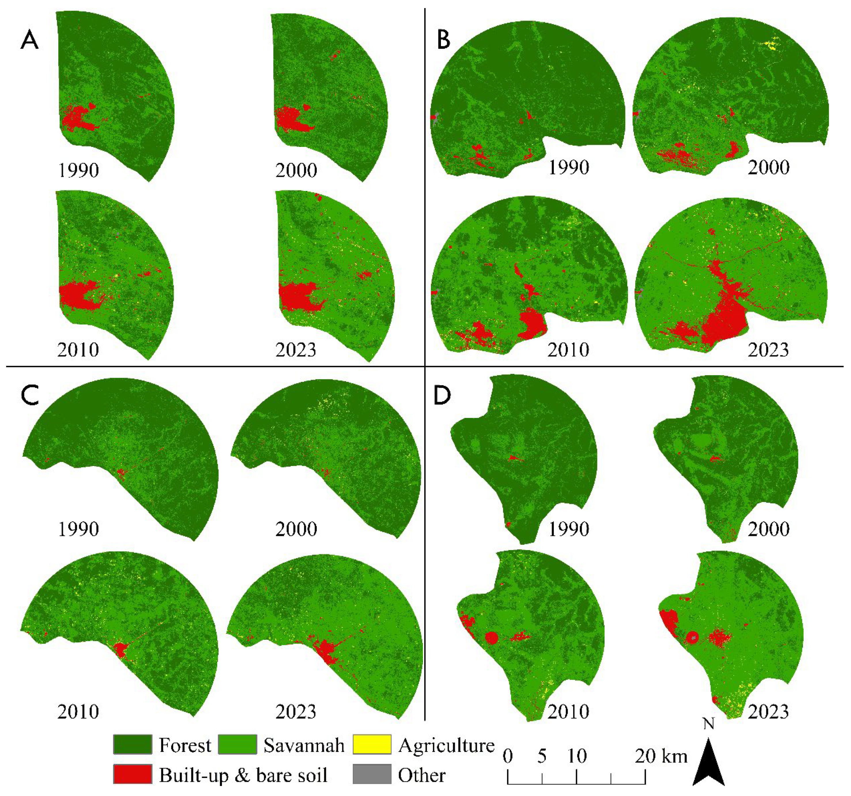
The visual analysis reveals the growth of built-up and bare soil is observed in different directions: eastward in the city of Kipushi, northward and southwestward in the city of Kasumbalesa, eastward in the city of Mokambo (C), and westward in the city of Sakania (D). Additionally, an important decrease in forest cover, particularly around the city of Kipushi (A) and the city of Kasumbalesa (B), were observed. Concurrently, savannas are gradually encroaching upon former forested areas around all cities studied, indicating a shift in ecosystem dynamics. There is also a noticeable increase in agricultural lands surrounding all four cities, underscoring the significant impacts of human activities on the landscape. The reduction in forest cover, coupled with the expansion of built-up and bare soil areas, agriculture, and savannas, highlights the extensive footprint of deforestation and urbanization on local landscapes.
Figure 2.
Mapping spatial land cover dynamics in Kipushi (A), Kasumbalesa (B), Mokambo (C), and Sakania (D) landscapes from 1990 to 2023 using supervised classification of Landsat images with the Random Forest classifier.
Figure 2.
Mapping spatial land cover dynamics in Kipushi (A), Kasumbalesa (B), Mokambo (C), and Sakania (D) landscapes from 1990 to 2023 using supervised classification of Landsat images with the Random Forest classifier.
3.2. Landscape Composition Dynamics
Between 1990 and 2023, there was a marked decrease in forest cover surrounding Kipushi, Kasumbalesa, Mokambo, and Sakania. Initially, forests dominated these regions, but by 2023, their extent had drastically diminished, with less than 15% remaining in Kipushi, 10% in Kasumbalesa, 30% in Mokambo, and 15% in Sakania. Conversely, savannas multiplied fourfold on average, built-up and bare soil increased eightfold, and agriculture surged by a factor of 46 across the four border cities. These changes signify a significant reshaping of the land cover in the region (Figure 3). Furthermore, an analysis using the Shannon Diversity Index indicated shifts in landscape composition, with Kasumbalesa, Mokambo, and Sakania displaying increased diversity between 1990 and 2023, suggesting a transition toward more heterogeneous landscapes. This transformation underscores the diversification of land cover characteristics and types within these border cities (Figure 4).
3.3. Intensity of Urban Expansion, Sprawl and Associated Landscape Anthropization
During the 1990-2000 decade, the urban expansion intensity index for Kipushi, Kasumbalesa, Mokambo, and Sakania was 0.08, 0.14, 0.02, and 0.03, respectively. These results indicate that Kasumbalesa experienced the most significant urban growth intensity during this period. From 2000 to 2010, there was a substantial increase in the urban expansion intensity index for all border cities studied, with values of 0.32, 0.29, 0.04, and 0.21 for Kipushi, Kasumbalesa, Mokambo, and Sakania, respectively. Compared to the previous decade, Kipushi saw a more pronounced urban expansion intensity during this period. Lastly, from 2010 to 2023, the urbanization intensity index continued to rise, reaching values of 0.54, 0.12, and 0.21 for Kasumbalesa, Mokambo, and Sakania, respectively. For the city of Kipushi, the value decreased fourfold during this period. These results indicate a more important urban expansion intensity in Kasumbalesa, placing it at the forefront in terms of spatial urban growth compared to the other studied cities (Figure 5).
However, the border cities of Kipushi, Kasumbalesa, Mokambo, and Sakania, along with their surrounding areas, experienced a progressive anthropization of their landscapes (Table 3). In 1990, the largest forested patch covered approximately 80% of the class area, with an average distance between patches of less than 70 meters. However, this largest patch area decreased by approximately 10%, while the average distance between forest patches multiplied nearly threefold by 2023. Concurrently, an inverse trend was observed for agriculture, savannas, as well as built-up and bare soil. Over the 33 years from 1990 and 2023, the average distance between their patches decreased, while the size of their respective largest patches increased (Table 3), suggesting a trend towards fragmentation and degradation of landscapes.
Additionally, during the period 1990-2023, a significant increase in disturbance index was observed within the landscapes of the studied border cities (Figure 6). In Kipushi, this index multiplied by 14, increasing from 0.5 in 1990 to 6.5 in 2023. In Kasumbalesa, an even more pronounced increase was noted, with a multiplication factor of 53, raising the index from 0.2 in 1990 to 11.8 in 2023. For Mokambo, the index multiplied by 10, increasing from 0.3 in 1990 to 2.8 in 2023. Lastly, in Sakania, the index multiplied by 37, reaching 7 in 2023 compared to an initial value of 0.2 in 1990 (Figure 6). These increases reflect a significant intensification of human activity in these regions over this 33-year period.
3.4. Analysis of Landscape Spatial Pattern Dynamics
Applying the decision tree algorithm of Bogaert et al. (2014) on the data in Table 4, our findings underscore that between 1990 and 2000, the forest experienced an increase in PN and a decrease in CA for the cities of Kipushi, Kasumbalesa, Mokambo, and Sakania, suggesting a spatial transformation process of dissection (tobs0.83>0,75). Conversely, the savannas, agriculture, and built-up and bare soil recorded an increase in both PN and CA, indicating a creation process.
During the period from 2000 to 2010, fragmentation was the dominant spatial transformation process for the forest for all studied border cities (tobs0.58<0,75), since the decrease of CA was accompanied by an increase in PN. Savannas exhibited an increase in CA and a decrease in PN, suggesting an aggregation-type spatial transformation process. Agriculture, and built-up and bare soil were characterized by an increase in PN and CA, indicating creation as the spatial transformation process. From 2010 to 2023, the forest showed an increase in PN and a decrease in CA for the border cities of Kipushi, Mokambo, and Sakania, indicating a process of fragmentation (tobs 0.38<0,75). However, around the border city of Kasumbalesa, there was a simultaneous decrease in both PN and CA of forest, indicating attrition as the spatial transformation process. Agriculture exhibited a process of patch creation, as the increase in CA resulted from an increase in PN. Finally, for savannas, and built-up and bare soil, there was noted a decrease in PN alongside an increase in CA, suggesting an aggregation-type spatial transformation process.
4. Discussion
4.1. Methodology
The use of Landsat images, despite its spatial resolution of 30 meters, remains pertinent due to its long-term availability, global coverage, and ability to capture multispectral data [54]. This characteristic allows for the analysis of regional-scale land cover changes, which is crucial for monitoring urban expansion evolution and associated landscape changes over time [54,55]. Among the available land cover classification algorithms, the Random Forest was selected for its capability to handle large volumes of multispectral data and produce detailed land cover maps. By employing a set of decision trees, this algorithm categorizes image pixels based on their spectral, spatial, and contextual characteristics, facilitating effective differentiation between various land cover types [56]. The combination of Landsat imagery and a Random Forest classifier proved effective in assessing urban expansion and associated landscape changes in the New Juaben Municipality, Ghana) [57]. Moreover, incorporating landscape metrics offers quantitative assessments of changes in urban landscape patterns and associated ecological impacts. Parameters like fragmentation, connectivity, urban patch shape, and landscape diversity serve as crucial tools for comprehending the dynamics of urban expansion, growth patterns, and their environmental repercussions) [58]. However, it's important to note that Landsat data primarily provides information on the physical environment and may not capture directly the social, economic, and political factors influencing landscape dynamics, which could be a limitation. Nevertheless, aligning Landsat image dates with significant events such as economic developments or political changes allowed to link observed spatial changes with these events, enhancing the understanding of how socio-political and economic factors impact urban spatial expansion, as demonstrated by Cabala et al. [31] in the KCA study. However, expanding the assessment of land cover changes through predictive modelling for future scenarios would be crucial for anticipating potential environmental impacts, including biodiversity loss, particularly in the context of climate change and unforeseen urban growth. Nevertheless, analyzing the period from 1990 to 2023 enables the identification of long-term landscape changes, such as urban area expansion, and shifts of ecosystems, offering insights into potential future developments. Similarly, studying land cover pattern dynamics is important as it enables deductions about ecological processes. For instance, while Li et al. [59] deduced a threat for biodiversity conservation in Shangai (China) through an increase in the cover of green space planted with exotic species.
4.2. Urban Expansion Intensity and Associated Landscape Dynamics
The period of 1990s-2001 was characterized by a slow urban expansion, along the RD Congo-Zambia border, due to political conflicts, leading to economic and social instability. Moreover, political tensions can disrupt commercial activities and hinder economic growth, thereby limiting employment opportunities and urban development [60]. Additionally, during conflict periods, priorities often shift towards addressing immediate security and political stability issues, relegating urbanization projects to the background [61]. Conversely, we found an acceleration in the urbanization extent during 2000-2010, which correspond to the period of progressive mining liberalization, favouring the increased of foreign and domestic investments, and stimulating economic growth and creating jobs. This economic growth also resulted in an increased demand for labor, attracting a growing population to urban areas near mining zones [62,63]. Khoji et al. [23] and Cabala et al. [31] findings corroborate the acceleration of the urbanization of main agglomerations within the KCA during the same period. Furthermore, mining companies could finance the construction of housing for mine workers, promoting the expansion of border cities [64].
The decade 2010-2023 is characterized by a new phase of rapid urbanization of the Congolese border cities due to political stabilization and economic recovery after the global financial crisis. Indeed, the increasing demand for mineral resources attracted new investments and labor, thereby stimulating urban growth. Yet, the increasing demand for housing among new citizens is driving uncontrolled urban expansion, extending beyond any form of government control. Indeed, Congolese cities are generally surpassing their own limits and encroaching on adjacent rural areas. Consequently, given the expensive urban lifestyle prevalent in many urban centers, a significant portion of the population in border cities opts for areas that maintain their rural essence, where land resources remain relatively affordable [65]. Concurrently, during this decade, the roads connecting the city of Lubumbashito Sakania via Mokambo and Kasumbalesa, have all been asphalted. This process has had a significant impact on the spatial expansion of Mokambo, notably by promoting the purchase of plots with traditional houses and their transformation into modern houses for customs officers and their families. This pattern aligns with Arimah's [66] findings regarding infrastructure's role in enhancing the prosperity of African cities. However, this trend of urban modernization can induce the loss of female local knowledge, particularly regarding the painting of traditional houses.
Unfortunately, the spatial urban expansion observed in border cities between the DRC and Zambia is largely driven by self-construction, leading to urban sprawl as revealed by the increase in CA and PN simultaneously, as well as UIIE. This self-construction is due to inadequate urban planning, gaps in land management, corruption, and the influence of political and economic interests on urban decisions [67]. This process often leads to the development of informal settlements with excessive low built-up density and limited access to basic services, as illustrated by Groupe Huit [68] in the city of Lubumbashi. Additionally, the self-construction favour land speculation, amplify socio-economic disparities, as well as food insecurity due to persistent agricultural activities displacement [69], despite the general trend of increase in the CA of agriculture between 1990 and 2023. Indeed, most farmers lack ownership titles, making their land vulnerable. On the other hand, land speculation makes the conversion of agricultural land into buildable land economically profitable in the short term and with lower risk [70]. Consequently, the spatial expansion of border cities leads to the exurbanization of some producers, transforming urban agriculture into peri-urban, and then rural agriculture. This shift is exacerbated by limited land availability and the prioritization of infrastructure over agricultural activities in (peri-)urban areas [71].
The expansion of built-up areas is accompanied by a decline in forest cover and an increase in savannahs around the studied border cities. Urbanization often leads to direct deforestation for building, road infrastructures, and other urban installations. Trees are cut down to make space, reducing forest cover, as demonstrated by Cabala et al. [35] in the Lubumbashi plain and Bamba et al. [72] in the Kisangani region in the DR Congo. Additionally, urban growth can favour the exploitation of surrounding natural resources for fuelwood or other forest products. Yet, excessive exploitation leads to a significant decrease in forest cover [41,73]. Moreover, urban expansion can stimulate the conversion of forested lands into agricultural lands to compensate for the loss of agricultural lands encroached upon by urbanization to meet the growing food needs of the urban population, as observed in Freetown [70]. However, the felling of trees promotes sunlight penetration, a crucial element for the development of herbaceous vegetation dominating savannahs [74], justifying the progression of savannahs in the surrounding areas of the studied border cities. Furthermore, the fragile fertility of agricultural lands in these regions often leads to their rapid abandonment after 2 to 3 years of cultivation, favouring their colonisation by herbaceous vegetation.
Our research findings affirm the impact of city size on deforestation, a notion supported by previous research [55,72]. The rapid urban expansion observed in Kasumbalesa can be attributed to the benefit from significant commercial flows due to its strategic position at national borders. This dynamic commercial activity creates employment opportunities, attracts investments, and stimulates economic growth, leading to rapid urban expansion. In contrast, territorial capital border cities or mining towns (i.e. Kipushi and Sakania) exhibited different characteristics since they may face specific challenges. These cities are more focused on a specific industry, which can limit their ability to diversify their economy and attract a more varied population. Similarly, territorial capital border cities are more focused on administrative and governmental functions, which can impact their economic dynamism and attractiveness to investors and migrants. Moreover, when examining the environmental impact of Kisangani, a city of considerable economic and demographic influence, in contrast to Ubundu, a city of moderate importance, Bamba et al. [72] discovered a more significant deforestation trend around Kisangani.
However, our results underline urban densification in Kipushi that can be attributed to the stable supply of electricity and water in the area. When infrastructures such as electricity and water are consistently available, it creates an environment conducive to the extension of former buildings. But, the recent trend of populations moving from Lubumbashi to settle in Kipushi could justify the urban sprawl observed in this city. This population movement can be attributed to the increasing insecurity in Lubumbashi. Additionally, job opportunities in mining industry may attract workers and their families. In contrast, the situation in Sakania is different due to the nature of its mining workforce. While the town hosts a significant number of mine workers, it is important to note that many of these workers come from other regions of the country and do not have their families and residence in Sakania.
4.2. Implications for Regional Urban Planning
Our findings highlight a rapid urban expansion and a trend towards urban sprawl in the studied border cities. Yet, urban sprawl contributes to community fragmentation, increased traffic congestion, and diminished quality of life through reduced green spaces and environmental degradation. It results also in escalated costs for infrastructure and public services, heightened transport inefficiencies, and reduced productivity associated with extended commuting times. To mitigate these effects, sustainable urban planning strategies are imperative. These encompass the implementation of urban densification policies aimed at optimizing the utilization of existing spatial resources, promotion of mixed-use urban development to minimize travel distances, and targeted investments in efficient public transportation infrastructure. Additionally, preserving green spaces and adopting urban growth management policies are pivotal for enhancing urban resilience and fostering balanced and sustainable urban development.
Our findings reveal that urban expansion leads to the disappearance of forests, posing threats to biodiversity conservation. Countless adverse effects of deforestation can be observed in the region, as the gradual disappearance of numerous non-timber forest resources [75], the noticeable reduction in wildlife [32], and the reduction in albedo, resulting in fewer rainy days [76]. Also, preserving agricultural land is crucial for ensuring food security in the area given its susceptibility to urban expansion. It is crucial to adopt environmental protection policies such as creating protected areas, strengthening land use regulations, and promoting sustainable agricultural practices. For illustration, the establishment of the Bururi Forest Reserve (near the city of Bururi, Burundi), with active ecoguards, has facilitated the regeneration of forest resources [77]. Concurrently, in the plateau des Batéke in Kinshasa (DR Congo), agroforestry practices that involve combining Acacia trees with maize crop enable households to enhance their yield and obtain wood for charcoal production in close proximity [78]. Certainly, reforestation solutions exist near the city of Kipushi [75]. However, despite ongoing progress, it has become evident that this positive human influence on the landscape through the planting of exotic species will not be sufficient to offset the loss of forest [79] while posing the risk of further ecosystem degradation [80]. It is crucial to utilize native species in reforestation projects and to enhance collaboration between traditional authorities and city managers to make more land available on the outskirts of cities for reforestation projects [81]. Additionally, there is a need to enhance the capacity of technical public service agents in terms of methodology and technical expertise to better supervise these types of reforestation projects and preserve reforested land in the long term [82]. Finally, the promotion of urban forestry in cities where green spaces are neglected and surrounding forests are disappearing is also an essential strategy for improving quality of life and the environment. By reducing air pollution, providing shade, lowering temperatures, and encouraging community participation through the planting of fruit trees, this approach creates healthier, more resilient, and more livable urban environments [83,84]. This integrated method is crucial for addressing the environmental and social challenges of contemporary urban areas, thereby promoting sustainability and collective well-being.
5. Conclusions
The study delves into the intricate spatial urban growth and associated landscape dynamics of Kipushi, Kasumbalesa, Mokambo and Sakania along the border with Zambia, an area of variable cross-border trade. Employing a robust methodology that integrates remote sensing, GIS, and landscape ecology analysis tools has facilitated a comprehensive mapping and quantification of landscape dynamics over time. The findings affirm that rapid population growth is primary driver of substantial landscape changes within these cities, leading to the transformation of natural landscapes into sprawl urban zones. However, there is the variance in the extent of urban expansion among cities, with those experiencing lower customs activity levels demonstrating a more restrained spatial urban growth. This discrepancy underscores the influential role of economic factors in shaping border urban dynamics, highlighting the intricate interplay of factors driving urban development in these regions. Additionally, the study has identified a marked acceleration in urban spatial growth since the early 2000s, indicating a swift transformation of these border agglomerations. This leads to an ecosystem shift, marked by a decline in forest cover, previously dominant in the landscapes of the cities studied in 1990, except for Kipushi, replaced by emerging and merging savannah patches in the landscape in 2023. The anthropization of the landscape of these cities and their heterogeneity are further intensified over time by the continuous creation of agricultural patches. These observations lead to the conclusion that border urban areas in the DRC-Zambia region are undergoing significant spatial changes driven by a complex interplay of economic, demographic, and infrastructural factors. Understanding these dynamics is crucial for informed urban planning and policy formulation. Sustainable development strategies must be devised to address challenges such as managing urban sprawl, promoting economic resilience, and fostering cross-border cooperation in border regions.
Author Contributions
Y.U.S.: conceptualisation, methodology and writing—original draft preparation; M.M.M.: writing—original draft preparation and data curation; F.M.: writing—review and editing; J.B.: supervision, writing—original draft and funding acquisition. All authors have read and agreed to the published version of the manuscript.
Funding
This work is supported by Academy for Research and Higher Education, Commission for Development Cooperation (Belgium).
Data Availability Statement
The authors confirm that all data supporting the findings of this study are available within the article.
Acknowledgments
The authors would like to thank the development research project "Capacity building for the sustainable management of the miombo clear forest through the assessment of the environmental impact of charcoal production and the improvement of forest resource management practices (CHARLU)" and the administrative services of the border cities studied for the facilities provided.
Conflicts of Interest
The authors have no conflicts of interest to declare. All co-authors have reviewed and approved the contents of the manuscript, and there are no financial interests to report. We confirm that the submission represents original work and is not currently under review by any other publication.
References
- Hussain, M.; Imitiyaz, I. Urbanization concepts, dimensions and factors. International Journal of Recent Scientific Research 2018, 9, 23513–23523. [Google Scholar] [CrossRef]
- Gu, D.; Andreev, K.; Dupre, M.E. Major Trends in Population Growth Around the World. China CDC Weekly 2021, 3, 604–613. [Google Scholar] [CrossRef] [PubMed]
- Cividino, S.; Halbac-Cotoara-Zamfir, R.; Salvati, L. Revisiting the “City Life Cycle”: Global urbanization and implications for regional development. Sustainability 2020, 12, 1–18. [Google Scholar] [CrossRef]
- UN Department of Economic and Social Affairs. World Urbanization Prospects. In Demographic Research 2018,12. Available online: https://population.un.org/wup/Publications/Files/WUP2018-Report.pdf (accessed on 14 April 2024).
- Sinka, M.E.; Pironon, S.; Massey, N.C.; Longbottom, J.; Hemingway, J.; Moyes, C.L.; Willis, K.J. A new malaria vector in Africa: Predicting the expansion range of Anopheles stephensi and identifying the urban populations at risk. Proceedings of the National Academy of Sciences of the United States of America 2020, 117, 24900–24908. [Google Scholar] [CrossRef] [PubMed]
- Paz, J.A. Demographic Dynamics, Poverty, and Inequality. In: May, J.F.; Goldstone, J.A. (eds) International Handbook of Population Policies. International Handbooks of Population, Springer 2022, 11,. [CrossRef]
- Baye, F.; Adugna, D.; Mulugeta, S. Administrative failures contributing to the proliferation and growth of informal settlements in Ethiopia: The case of Woldia Township. Heliyon 2023, 9, e13758. [Google Scholar] [CrossRef] [PubMed]
- Schlesinger, J.; Drescher, A.; Shackleton, C.M. Socio-spatial dynamics in the use of wild natural resources: Evidence from six rapidly growing medium-sized cities in Africa. Applied Geography 2015, 56, 107–115. [Google Scholar] [CrossRef]
- Stacey, P.; Lund, C. In a state of slum: Governance in an informal urban settlement in Ghana. Journal of Modern African Studies 2016, 54, 591–615. [Google Scholar] [CrossRef]
- Pieterse, E.; Parnell, S.; Haysom, G. African dreams: locating urban infrastructure in the 2030 sustainable developmental agenda. Area Development and Policy 2018, 3, 149–169. [Google Scholar] [CrossRef]
- Nugent, P. Border Towns and Cities in Comparative Perspective. A Companion to Border Studies 2012, 557–572. [Google Scholar] [CrossRef]
- Dobler, G. The green, the grey and the blue: A typology of cross-border trade in Africa. Journal of Modern African Studies 2016, 54, 145–169. [Google Scholar] [CrossRef]
- Cappellano, F.; Kurowska-Pysz, J. The mission-oriented approach for (cross-border) regional development. Sustainability 2020, 12, 1–17. [Google Scholar] [CrossRef]
- Rimal, B.; Zhang, L.; Keshtkar, H.; Haack, B.N.; Rijal, S.; Zhang, P. Land use/land cover dynamics and modeling of urban land expansion by the integration of cellular automata and markov chain. ISPRS International Journal of Geo-Information 2018, 7. [Google Scholar] [CrossRef]
- Soi, I.; Nugent, P. Peripheral Urbanism in Africa: Border Towns and Twin Towns in Africa. Journal of Borderlands Studies 2017, 32, 535–556. [Google Scholar] [CrossRef]
- Peša, I. Crops and Copper: Agriculture and Urbanism on the Central African Copperbelt, 1950–2000. Journal of Southern African Studies 2020, 46, 527–545. [Google Scholar] [CrossRef]
- Mususa, P. Mining, welfare and urbanisation: The wavering urban character of Zambia’s Copperbelt. Journal of Contemporary African Studies 2012, 30, 571–587. [Google Scholar] [CrossRef]
- Mabin, A.; Butcher, S.; Bloch, R. Peripheries, suburbanisms and change in sub-Saharan African cities. Social Dynamics 2013, 39, 167–190. [Google Scholar] [CrossRef]
- Larmer, M. Permanent precarity: capital and labour in the Central African copperbelt. Labor History 2017, 58, 170–184. [Google Scholar] [CrossRef]
- Rubbers, B. Mining towns, enclaves and spaces: A genealogy of worker camps in the Congolese copperbelt. Geoforum 2019, 98, 88–96. [Google Scholar] [CrossRef]
- Baruah, N.G.; Henderson, J.V.; Peng, C. Colonial legacies: Shaping African cities. Journal of Economic Geography 2021, 21, 29–65. [Google Scholar] [CrossRef]
- Mwitwa, J.; German, L.; Muimba-Kankolongo, A.; Puntodewo, A. Governance and sustainability challenges in landscapes shaped by mining: mining forestry linkages and impacts in the Copper Belt of Zambia and the DR Congo. Forest Policy and Economics 2012, 25, 19–30. [Google Scholar] [CrossRef]
- Khoji, M.H.; Nghonda, D.D.N.; Malaisse, F.; Waselin, S.; Sambiéni, K.R.; Kaleba, S.C.; Kankumbi, F.M.; Bastin, J.F.; Bogaert, J.; Sikuzani, Y.U. Quantification and Simulation of Landscape Anthropization around the Mining Agglomerations of Southeastern Katanga (DR Congo) between 1979 and 2090. Land 2022, 11. [Google Scholar] [CrossRef]
- Cuvelier, J.; Mumbund, P.M. Réforme douanière néolibérale, fragilité étatique et pluralisme normatif. Politique Africaine 2013, 129, 93–112. [Google Scholar] [CrossRef]
- Van Wilderode, J.; Heijlen, W.; De Muynck, D.; Schneider, J.; Vanhaecke, F.; Muchez, P. The Kipushi Cu-Zn deposit (DR Congo) and its host rocks: A petrographical, stable isotope (O, C) and radiogenic isotope (Sr, Nd) study. Journal of African Earth Sciences 2013, 79, 143–156. [Google Scholar] [CrossRef]
- Useni, S.Y.; Kaleba, S.C.; Khonde, C.N.; Mwana, Y.A.; Malaisse, F.; Bogaert, J.; Kankumbi, F.M. Vingt-cinq ans de monitoring de la dynamique spatiale des espaces verts en réponse á ('urbanisation dans les communes de la ville de Lubumbashi (Haut-Katanga, RD Congo). Tropicultura 2017, 35, 300–311. [Google Scholar] [CrossRef]
- Rodriguez Lopez, J.M.; Heider, K.; Scheffran, J. Human and remote sensing data to investigate the frontiers of urbanization in the south of Mexico City. Data in Brief 2017, 11, 5–11. [Google Scholar] [CrossRef] [PubMed]
- Xu, X.; Min, X. Quantifying spatiotemporal patterns of urban expansion in China using remote sensing data. Cities 2013, 35, 104–113. [Google Scholar] [CrossRef]
- Lin, M.; Lin, T.; Jones, L.; Liu, X.; Xing, L.; Sui, J.; Zhang, J.; Ye, H.; Liu, Y.; Zhang, G.; Lu, X. Quantitatively assessing ecological stress of urbanization on natural ecosystems by using a landscape-adjacency index. Remote Sensing 2021, 13. [Google Scholar] [CrossRef]
- Lisa, P.; Christian, L.; Karen, B.; Blake, W. Armed conflict and cross-border asymmetries in urban development: A contextualized spatial analysis of Goma, Democratic Republic of the Congo and Gisenyi, Rwanda. Land Use Policy 2021, 109, 105711. [Google Scholar] [CrossRef]
- Cabala, K.S.; Useni, S.Y.; Sambieni, K.R.; Bogaert, J.; Kankumbi, F.M. Dynamique des écosystémes forestiers de I'Arc Cuprifére Katangais en République Démocratique du Congo. I. Causes, transformations spatiales et ampleur. Tropicultura 2017, 35, 192–202. [Google Scholar]
- Malaisse, F. How to Live and Survive in Zambezian Open Forest (Miombo Ecoregion); Presses Agronomiques de Gembloux: Gembloux, Belgium, 2010. [Google Scholar]
- Van Engelen, V.; Verdoodt, A.; Dijkshoorn, K.; Van Ranst, E. Soil and Terrain Database of Central Africa-DR of Congo, Burundi and Rwanda (SOTERCAF, version 1.0). ISRIC FAO, Report 2006, 7, 07.
- Potapov, P.V.; Turubanova, S.A.; Hansen, M.C.; Adusei, B.; Broich, M.; Altstatt, A.; Mane, L.; Justice, C.O. Quantifying forest cover loss in Democratic Republic of the Congo, 2000-2010, with Landsat ETM+ data. Remote Sensing of Environment 2012, 122, 106–116. [Google Scholar] [CrossRef]
- Cabala, K.S.; Useni Sikuzani, Y.; Mwana, Y.A.; Bogaert, J.; Kankumbi, F.M. Pattern Analysis of Forest Dynamics of the Katangese Copper Belt Region in the Democratic Republic of the Congo: II. Complementary Analysis on Forest Fragmentation. Tropicultura 2018, 36, 621–630. [Google Scholar]
- Yamba, A.M.; Isabelle Vranken, Jules Nkulu, François Lubala Toto Ruananz, Daniel Kyanika, Scott Tshibang Nawej, Flori Mastaki Upite, Jean-Pierre Bulambo Mwema,; Bogaert, J. L’activité minière au Katanga et la perception de ses impacts à Lubumbashi, Kolwezi, Likasi et Kipushi. In Anthropisation des paysages katangais ; Presses Agronomiques de Gembloux: Gembloux, Belgium, 2018, p. 267.
- INS (Institut National de la Statistique). Anuaire statistique RDC 2022. Ministère National du Plan, Kinshasa, RD Congo, 2022, 433p.
- Chapa, F.; Hariharan, S.; Hack, J. A new approach to high-resolution urban land use classification using open access software and true color satellite images. Sustainability 2019, 11. [Google Scholar] [CrossRef]
- Barima, Y.S.S.; Egnankou, W.M.; N’doumé, A.T.C.; Kouamé, F.N.; Bogaert, J. Modélisation de la dynamique du paysage fores- tier dans la région de transition forêt-savane à l’est de la Côte d’Ivoire. Télédétection 2010, 9, 129–138. [Google Scholar]
- Barima, Y.S.S.; Barbier, N.; Bamba, I.; Traoré, D.; Lejoly, J.; Bogaert, J. Dynamique paysagère en milieu de transition forêt-savane ivoirienne. Bois; Forêts Des Tropiques 2009, 299. [CrossRef]
- Mpanda, M.M.; Muteya, H.K.; Nghonda, D.D.N.; Sambiéni, K.R.; Malaisse, F.; Kaleba, S.C.; Bogaert, J.; Sikuzani, Y.U. Uncontrolled Exploitation of Pterocarpus tinctorius Welw. and Associated Landscape Dynamics in the Kasenga Territory: Case of the Rural Area of Kasomeno (DR Congo). Land 2022, 11. [Google Scholar] [CrossRef]
- Useni, S.Y.; Mpanda, M.M.; Malaisse, F.; Kaseya, P.K.; Bogaert, J. The Spatiotemporal Changing Dynamics of Miombo Deforestation and Illegal Human Activities for Forest Fire in Kundelungu National Park, Democratic Republic of the Congo. Fire 2023, 6. [Google Scholar] [CrossRef]
- Useni, S.Y.; Mpanda Mukenza, M.; Khoji Muteya, H.; Cirezi Cizungu, N.; Malaisse, F.; Bogaert, J. Vegetation Fires in the Lubumbashi Charcoal Production Basin (The Democratic Republic of the Congo): Drivers, Extent and Spatiotemporal Dynamics. Land 2023, 12, 2171. [Google Scholar] [CrossRef]
- Noi Phan, T.; Kuch, V.; Lehnert, L.W. Land cover classification using google earth engine and random forest classifier-the role of image composition. Remote Sensing 2020, 12. [Google Scholar] [CrossRef]
- Olofsson, P.; Foody, G.M.; Herold, M.; Stehman, S.V.; Woodcock, C.E.; Wulder, M.A. Good practices for estimating area and assessing accuracy of land change. Remote Sensing of Environment 2014, 148, 42–57. [Google Scholar] [CrossRef]
- Cochran, W.G. Sampling Techniques; John Wiley and Sons: New York, NY, USA, 1977. [Google Scholar]
- Bogaert, J.; Ceulemans, R.; Salvador-Van Eysenrode, D. Decision Tree Algorithm for Detection of Spatial Processes in Landscape Transformation. Environmental Management 2004, 33, 62–73. [Google Scholar] [CrossRef] [PubMed]
- O'Neill, R.V.; Krummel, J.R.; Gardner, R.E.A.; Sugihara, G.; Jackson, B.; DeAngelis, D.L.; Milne, B.T.; Turner, M.G.; Zygmunt, B.S.; Christensen, W.; Dale, V.H.; Graham, R.L. Indices of landscape pattern. Landscape ecology 1988, 1, 153–162. [Google Scholar] [CrossRef]
- McGarigal, K. FRAGSTATS help. University of Massachusetts: Amherst, MA, USA, 2015, 182.
- Useni, Y.S.; André, M.; Mahy, G.; Kaleba, S.C.; Malaisse, F.; Kankumbi, F.M.; Bogaert, J. Interprétation paysagère du processus d’urbanisation à Lubumbashi: Dynamique de la structure spatiale et suivi des indicateurs écologiques entre 2002 et 2008. In Anthropisation des Paysages Katangais; Presses Agronomiques de Gembloux: Gembloux, Belgium, 2018; 281p. [Google Scholar]
- Manesha, E.P.P.; Jayasinghe, A.; Kalpana, H.N. Measuring urban sprawl of small and medium towns using GIS and remote sensing techniques: A case study of Sri Lanka. Egyptian Journal of Remote Sensing and Space Science 2021, 24, 1051–1060. [Google Scholar] [CrossRef]
- Mama, A. ; Sinsin, B. ; De Cannière, C.; Bogaert,; J. Anthropisation et dynamique des paysages en zone soudanienne au nord du Bénin. Tropicultura 2013, 31, 78–88.
- de Haulleville, T. ; Rakotondrasoa, O.L. ; Rakoto Ratsimba, H. ; Bastin, J.F. ; Brostaux, Y. ; Verheggen, F.J., Rajoelison, G.L. ; Malaisse, F. ; Poncelet, M. ; Haubruge, É. ; Beeckman, H.; Bogaert, J. Fourteen years of anthropization dynamics in the Uapaca bojeri Baill. forest of Madagascar. Landscape and Ecological Engineering 2018, 14, 135–146. [CrossRef]
- Schug, F.; Okujeni, A.; Hauer, J.; Hostert, P.; Nielsen, J.; van der Linden, S. Mapping patterns of urban development in Ouagadougou, Burkina Faso, using machine learning regression modeling with bi-seasonal Landsat time series. Remote Sensing of Environment 2018, 210, 217–228. [Google Scholar] [CrossRef]
- Forget, Y.; Shimoni, M.; Gilbert, M.; Linard, C. Mapping 20 years of urban expansion in 45 urban areas of sub-Saharan Africa. Remote Sensing 2021, 13, 1–19. [Google Scholar] [CrossRef]
- Amini, S.; Saber, M.; Rabiei-Dastjerdi, H.; Homayouni, S. Urban Land Use and Land Cover Change Analysis Using Random Forest Classification of Landsat Time Series. Remote Sensing 2022, 14, 1–23. [Google Scholar] [CrossRef]
- Nyamekye, C.; Kwofie, S.; Ghansah, B.; Agyapong, E.; Boamah, L.A. Assessing urban growth in Ghana using machine learning and intensity analysis: A case study of the New Juaben Municipality. Land Use Policy 2020, 99. [Google Scholar] [CrossRef]
- York, A.M.; Shrestha, M.; Boone, C.G.; Zhang, S.; Harrington, J.A.; Prebyl, T.J.; Swann, A.; Agar, M.; Antolin, M.F.; Nolen, B.; Wright, J.B.; Skaggs, R. Land fragmentation under rapid urbanization: A cross-site analysis of Southwestern cities. Urban Ecosystems 2011, 14, 429–455. [Google Scholar] [CrossRef]
- Li, J.; Li, C.; Zhu, F.; Song, C.; Wu, J. Spatiotemporal pattern of urbanization in Shanghai, China between 1989 and 2005. Landscape Ecology 2013, 28, 1545–1565. [Google Scholar] [CrossRef]
- Giacalone, M.; Turco, R.; Mosconi, E.M.; Alaimo, L.S.; Salvati, L. The Way Toward Growth: A Time-series Factor Decomposition of Socioeconomic Impulses and Urbanization Trends in a Pre-crisis European Region. Social Indicators Research 2023. [Google Scholar] [CrossRef]
- Buhaug, H.; Urdal, H. An urbanization bomb? Population growth and social disorder in cities. Global Environmental Change 2013, 23, 1–10. [Google Scholar] [CrossRef]
- MacMillan, H. Mining, housing and welfare in South Africa and Zambia: An historical perspective. Journal of Contemporary African Studies 2012, 30, 539–550. [Google Scholar] [CrossRef]
- Emuze, F.; Hauptfleisch, C. The Impact of Mining Induced Urbanization: A Case Study of Kathu in South Africa. Journal of Construction Project Management and Innovation 2014, 4, 882–894. [Google Scholar]
- Ebeke, C.H.; Ntsama Etoundi, S.M. The Effects of Natural Resources on Urbanization, Concentration, and Living Standards in Africa. World Development 2017, 96, 408–417. [Google Scholar] [CrossRef]
- Goodfellow, T. Urban fortunes and skeleton cityscapes: real estate and late urbanization in Kigali and Addis Ababa. International Journal of Urban and Regional Research 2017, 41, 786–803. [Google Scholar] [CrossRef]
- Arimah, B. Infrastructure as a Catalyst for the Prosperity of African Cities. Procedia Engineering 2017, 198, 245–266. [Google Scholar] [CrossRef]
- Beeckmans, L.; Lagae, J. Kinshasa’s syndrome-planning in historical perspective: From Belgian colonial capital to self-constructed megalopolis. In Urban Planning in Sub-Saharan Africa, Routledge, 2015,pp. 223-246.
- Groupe Huit. Elaboration du plan urbain de référence de Lubumbashi. Rapport final Groupe Huit, BEAU, Ministère des ITR, RD Congo, 2009, 62p.
- Djeufack Dongmo, A.; Avom, D. Urbanization, civil conflict, and the severity of food insecurity in Africa. Politics & Policy 2024, 52, 140-168. [CrossRef]
- Forkuor, G.; Cofie, O. Dynamics of land-use and land-cover change in Freetown, Sierra Leone and its effects on urban and peri-urban agriculture - a remote sensing approach. International Journal of Remote Sensing 2011, 32, 1017–1037. [Google Scholar] [CrossRef]
- Tambwe, N.A. Urban agriculture, land sustainability. The case of Lubumbashi. In Bogaert, J.;; Halleux, J.M. (Eds). Territoires périurbains : développement, enjeux et perspectives dans les pays du sud. Les presses agronomiques de Gembloux, Gembloux, Belgique, 2015; 153-162.
- Bamba, I.; Yedmel, M.S.; Bogaert, J. Effets des routes et des villes sur la forêt dense dans la province orientale de la République Démocratique du Congo. European Journal of Scientific Research 2010, 43, 417–429. [Google Scholar]
- N’tambwe Nghonda, D.-d.; Muteya, H.K.; Kashiki, B.K.W.N.; Sambiéni, K.R.; Malaisse, F.; Sikuzani, Y.U.; Kalenga, W.M.; Bogaert, J. Towards an Inclusive Approach to Forest Management: Highlight of the Perception and Participation of Local Communities in the Management of miombo Woodlands around Lubumbashi (Haut-Katanga, D.R. Congo). Forests 2023, 14, 687. [Google Scholar] [CrossRef]
- Useni, S.Y.; Boisson, S.; Cabala Kaleba, S.; Nkuku Khonde, C.; Malaisse, F.; Halleux, J.M.; Bogaert, J.; Munyemba Kankumbi, F. Dynamique de l'occupation du sol autour des sites miniers le long du gradient urbain-rural de la ville de Lubumbashi, RD Congo. Biotechnologie, Agronomie, Société et Environnement 2020, 24. [Google Scholar] [CrossRef]
- Münkner, C.-A.; Bouquet, M.; Muakana, R. Elaboration du schéma directeur d’approvisionnement durable en bois-énergie pour la ville de Lubumbashi (Katanga). Programme Biodiversité et Forêts, RD Congo,2015, 68p.
- Sanga-Ngoie, K.; Fukuyama, K. Interannual and long-term of climate variability over the Zaïre basin during the last 30 years. Journal of Geophysical Research 1996, 110, 21351–21360. [Google Scholar] [CrossRef]
- Havyarimana, F.; Masharabu, T.; Kouao, JK.; Bamba, I.; Nduwarugira, D.; Bigendako, MJ.; Hakizimana, P.; Mama, A.; Bangirinama, F.; Banyankimbona, G.; Bogaert, J.; De canniere, C. La dynamique spatiale de la forêt située dans la réserve naturelle forestière de Bururi au Burundi. Tropicultura 2017, 35, 158–172. [Google Scholar]
- Bisiaux, F. ; Peltier, R. ; Muliele, JC. Plantations industrielles et agroforesterie au service des populations des plateaux Batéké, Mampu, en République Démocratique du Congo. Bois et Forêts Trop, 2009. [CrossRef]
- Toyi, M.S.; Barima, S.; Mama, A.; Andre, M.; Bastin, J.F.; De Cannière, C.; Brice, S.; Bogaert, J. Tree plantation will not compensate natural woody vegetation cover loss in the Atlantic Department of Southern Benin. Tropicultura 2013, 31, 62–70. [Google Scholar]
- Wang, X.; Wang, Y.; Wang, Y. Use of exotic species during ecological restoration can produce effects that resemble vegetation invasions and other unintended consequences. Ecological engineering 2013, 52, 247–251. [Google Scholar] [CrossRef]
- Kaumbu, K.; Mubemba Mulambi Michel, M.; Emery Lenge Mukonzo, K.; Mylor, N.S.; Honoré, T.; Nkombe Alphonse, K.; Khasa, D. Early selection of tree species for regeneration in degraded woodland of southeastern Congo Basin. Forests 2021, 12, 117. [Google Scholar] [CrossRef]
- de Vries, W.T.; Chigbu, U.E.; Duran-Diaz, P. Twenty years of building capacity in land management, land tenure and urban land governance. In: Home, R. (Ed.), Land Issues for Urban Governance in Sub-Saharan Africa. Springer, Cham, Switzerland 2021, pp. 121 – 136.
- Gwedla, N.; Shackleton, C.M. The development visions and attitudes towards urban forestry of officials responsible for greening in South African towns. Land Use Policy 2015, 42, 17–26. [Google Scholar] [CrossRef]
- Useni, Y.S.; Malaisse, F.; Yona, J.M.; Mwamba, T.M.; Bogaert, J. Diversity, use and management of household-located fruit trees in two rapidly developing towns in Southeastern DR Congo. Urban Forestry & Urban Greening 2021, 63, 127220. [Google Scholar] [CrossRef]
Figure 1.
Geographical location of the Congolese cities bordering Zambia: Kipushi, Kasumbalesa, Mokambo and Sakania in the south-eastern region of the Democratic Republic of Congo (DRC). The background image and references were supplied by the American company ESRI (Environmental Systems Rechearch Institute). A geometric center (centroid) was defined for each city. From this center, a 15-kilometer radius was drawn, covering the built-up area and the city's periphery, which were then analyzed. This area corresponds to 307.22 km², 534.87 km², 424.64 km², and 468.60 km² respectively for the cities of Kipushi, Kasumbalesa, Mokambo, and Sakania respectively.
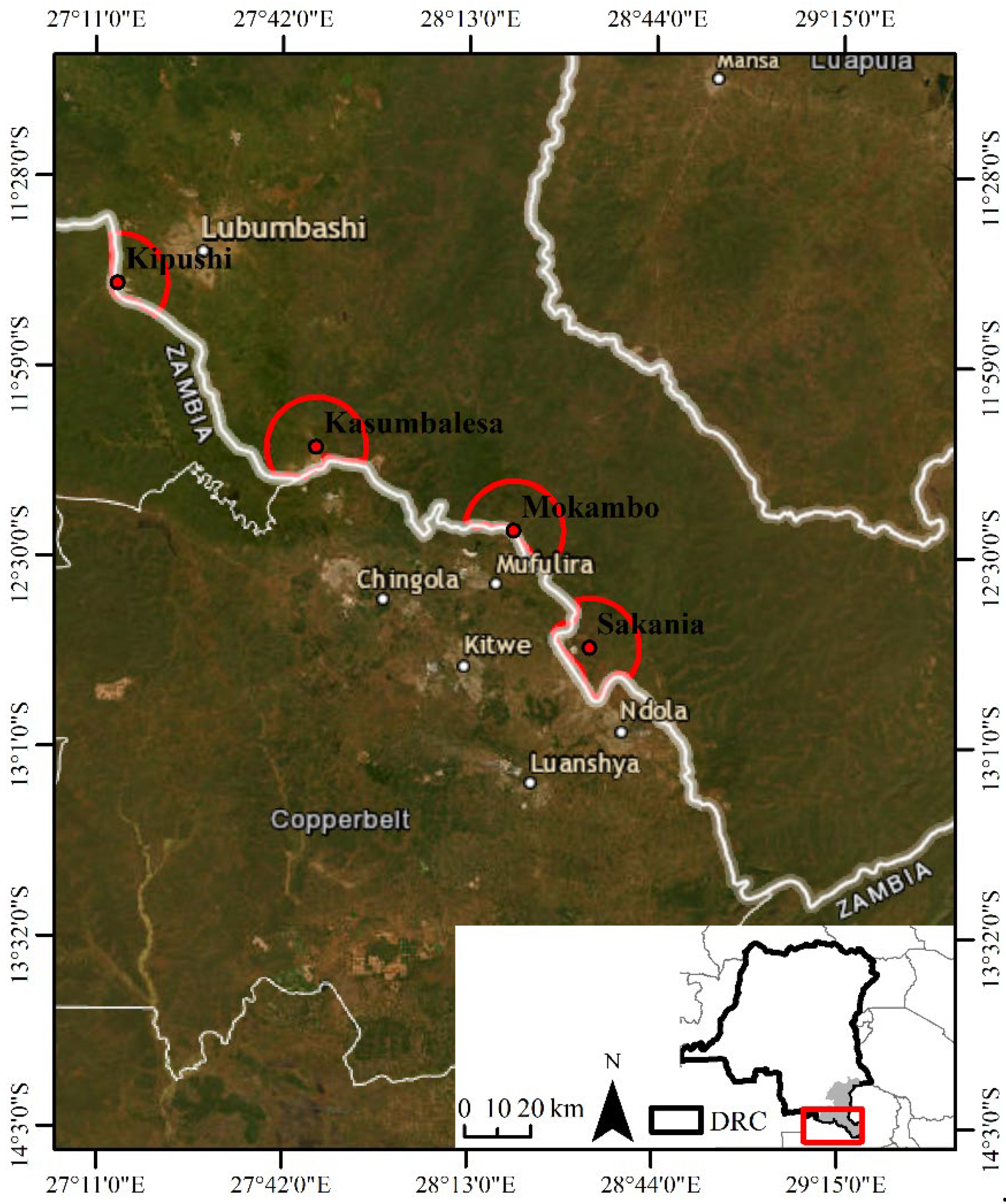
Figure 3.
Landscape composition evolution in Congolese Cities (Kipushi, Kasumbalesa, Mokambo, and Sakania) bordering Zambia from 1990 to 2023. The total landscape proportion for each city does not sum to 100% as other land cover classes were excluded from the analyses due to their relatively stable nature. The dynamics of landscape composition are evidenced by deforestation alongside the expansion of built-up and bare soil, agriculture, and savannas.
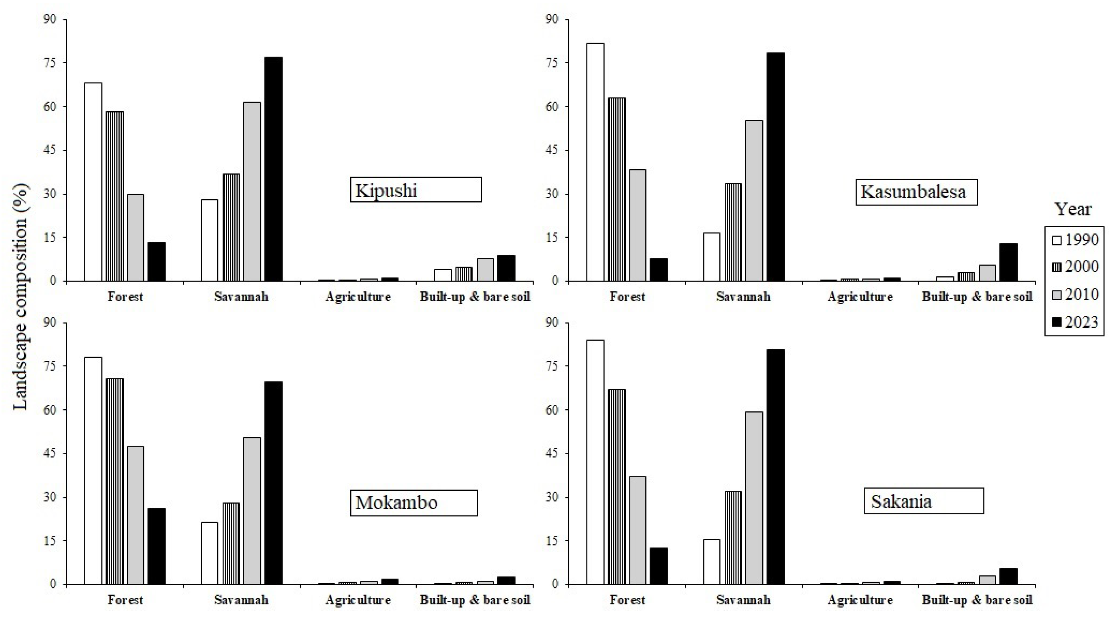
Figure 4.
Landscape diversity dynamics of the cities of Kipushi, Kasumbalesa, Mokambo, and Sakania between 1990 and 2020. The studied cities are characterized by a transition marked by the shift from a less diversified landscape to a heterogeneous landscape over time.
Figure 4.
Landscape diversity dynamics of the cities of Kipushi, Kasumbalesa, Mokambo, and Sakania between 1990 and 2020. The studied cities are characterized by a transition marked by the shift from a less diversified landscape to a heterogeneous landscape over time.
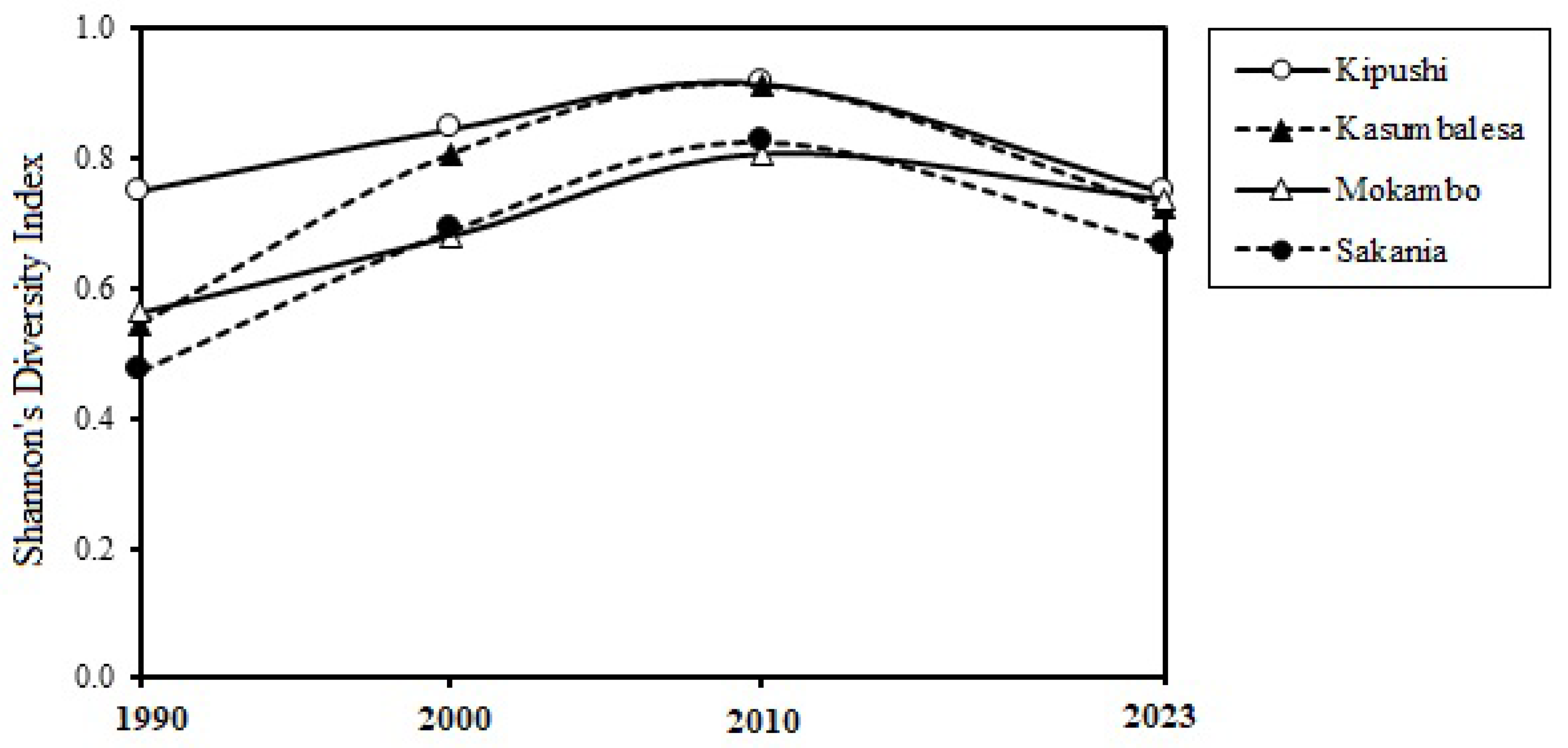
Figure 5.
Variation of the urban expansion intensity index between 1990-2000, 2000-2010 and 2010-2023 within the landscapes of the border cities of Kipushi, Kasumbalesa, Mokambo and Sakania. Urbanization is significantly more intense in Kasumbalesa, while relative stability was noted in Kipushi between 1990 and 2023.
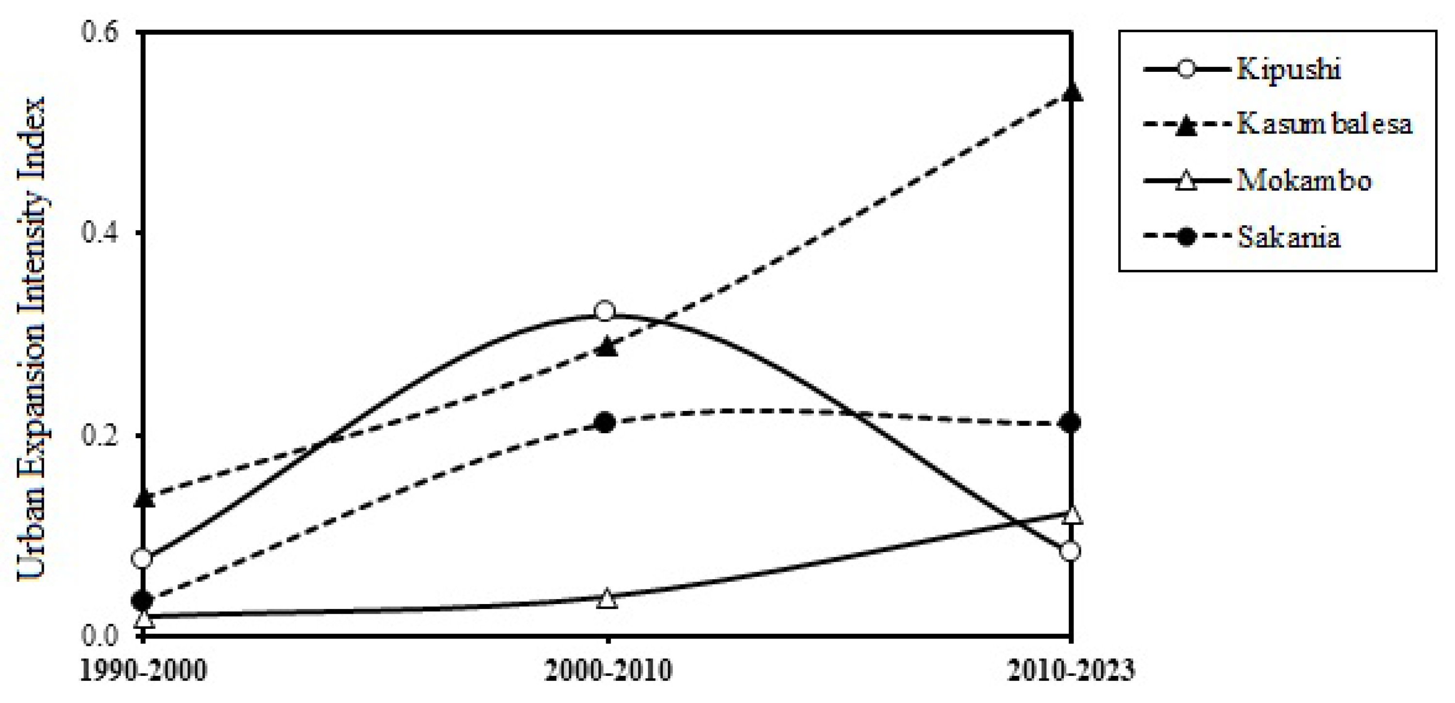
Figure 6.
Evolution of the landscape disturbance index of the cities of Kipushi, Kasumbalesa, Mokambo and Sakania between 1990 and 2023. There is an increase of the disturbance index across the time, reflecting a significant intensification of human activity in these cities.
Figure 6.
Evolution of the landscape disturbance index of the cities of Kipushi, Kasumbalesa, Mokambo and Sakania between 1990 and 2023. There is an increase of the disturbance index across the time, reflecting a significant intensification of human activity in these cities.
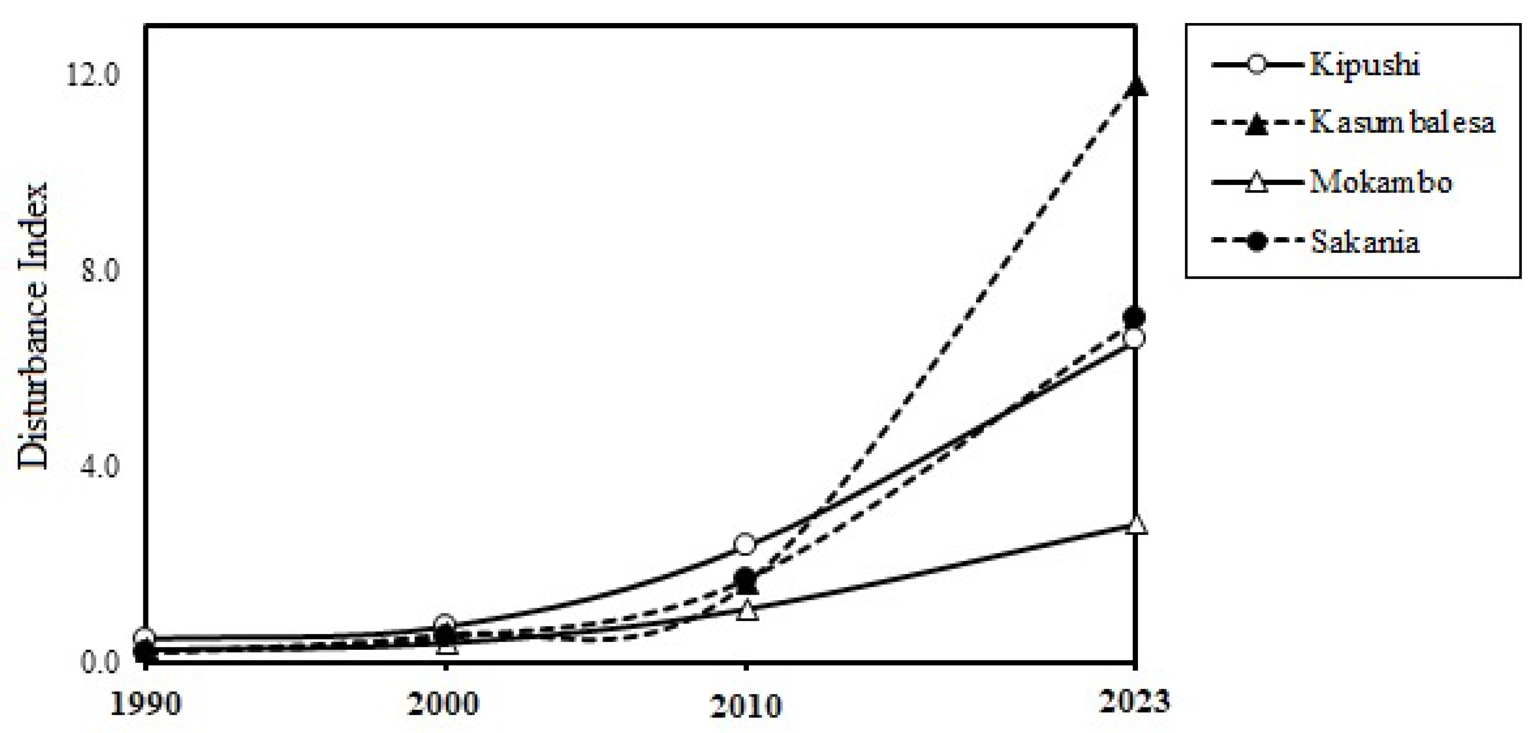

Table 1.
Description of land cover classes obtained after supervised classification of Landsat images on GEE, based on the Random Forest Classifier. ROI: Regions of Interest.
Table 1.
Description of land cover classes obtained after supervised classification of Landsat images on GEE, based on the Random Forest Classifier. ROI: Regions of Interest.
| Land cover | Description | ROI (Polygons) |
|---|---|---|
 |
Forest: Natural land cover, comprising patches of miombo woodland, dry dense forest, and gallery forest. | 170 |
 |
Savannah: Generally anthropogenic land cover, characterized by low tree density and predominance of herbaceous cover. | 170 |
 |
Agriculture: The anthropogenic land cover class consists of harvested agricultural lands, abandoned agricultural lands, or lands occupied by annual and off-season crops. | 120 |
 |
Built-up & bare soil: Bare land and residential areas with minimal vegetation; impermeable surfaces or rarely paved roads. | 150 |
 |
Other land cover: Water and unclassified spaces. | 90 |
Table 2.
Evaluation of accuracy and area estimation of land cover change maps from 1990 to 2023 based on supervised classification of Landsat images using the Random Forest classifier. FR: Forest; SV: Savanna; AG: Agriculture; BBS: Built-up & bare soil; OT: Other land cover; UA: User Accuracy; PA: Producer Accuracy; CI: Confidence Interval. The change in the "OT" land cover was not evaluated due to its relative stability across all studied periods and cities.
| 1990-2000 | FR | SV | AG | BBS | OT | FR Loss | SV Gain | AG Gain | BBS Gain |
| Accuracy measure | |||||||||
| PA [%] | 99.09 | 100 | 98.97 | 93.58 | 100 | 98.05 | 100 | 98.06 | 93.58 |
| UA [%] | 100 | 99.02 | 96.04 | 97.14 | 100 | 99.01 | 97.06 | 98.06 | 97.14 |
| Overall accuracy [%] | 97.56 | ||||||||
| Stratified estimators of area ± CI [% of total map area] | |||||||||
| Area [%] | 18.14 | 18.23 | 9.12 | 9.29 | 9.20 | 8.94 | 8.67 | 9.65 | 8.76 |
| 95% CI | 0.42 | 0.00 | 0.35 | 0.00 | 0.17 | 0.17 | 0.38 | 0.54 | 0.30 |
| 2000-2010 | FR | SV | AG | BBS | OT | FR Loss | SV Gain | AG Gain | BBS Gain |
| Accuracy measure | |||||||||
| PA [%] | 99.00 | 94.42 | 98.99 | 98.00 | 96.00 | 98.11 | 98.10 | 100.00 | 100.00 |
| UA [%] | 99.01 | 100.00 | 98.00 | 97.09 | 98.06 | 99.05 | 99.04 | 98.99 | 95.10 |
| Overall accuracy [%] | 97.40 | ||||||||
| Stratified estimators of area ± CI [% of total map area] | |||||||||
| Area [%] | 19.30 | 16.95 | 9.30 | 9.21 | 8.66 | 9.21 | 9.21 | 8.94 | 9.21 |
| 95% CI | 0.25 | 0.47 | 0.30 | 0.25 | 0.18 | 0.25 | 0.31 | 0.31 | 0.31 |
| 2010-2023 | FR | SV | AG | BBS | OT | FR Loss | SV Gain | AG Gain | BBS Gain |
| Accuracy measure | |||||||||
| PA [%] | 99.00 | 96.49 | 100.00 | 97.02 | 100.00 | 96.04 | 98.04 | 97.98 | 95.06 |
| UA [%] | 99.02 | 98.00 | 95.17 | 99.02 | 98.97 | 99.00 | 99.01 | 98.98 | 100.00 |
| Overall accuracy [%] | 96.30 | ||||||||
| Stratified estimators of area ± CI [% of total map area] | |||||||||
| Area [%] | 18.32 | 17.96 | 10.30 | 9.21 | 8.66 | 10.21 | 9.21 | 9.94 | 8.21 |
| 95% CI | 0.26 | 0.46 | 0.33 | 0.25 | 0.18 | 0.27 | 0.31 | 0.31 | 0.31 |
Table 3.
Evolution of the Largest Patch Index (LPI) and Mean Euclidean Nearest-Neighbor (ENN) of forest, built-up and bare soil, agriculture, and savanna patches between 1990 and 2023 in the landscapes of the border cities of Kipushi, Kasumbalesa, Mokambo, and Sakania. A trend towards fragmentation and degradation of landscapes around the studied border cities is noted.
| Border city | ||||||||
|---|---|---|---|---|---|---|---|---|
| Kipushi | Kasumbalesa | Mokambo | Sakania | |||||
| Indices | LPI | ENN | LPI | ENN | LPI | ENN | LPI | ENN |
| 1990 | ||||||||
| Forest | 63.84 | 68.54 | 79.75 | 68.40 | 74.67 | 67.01 | 82.43 | 67.08 |
| Savannah | 14.83 | 83.19 | 6.35 | 87.13 | 10.33 | 82.27 | 3.30 | 87.52 |
| Agriculture | 0.01 | 1986.84 | 0.00 | 530.87 | 0.00 | 263.60 | 0.00 | 438.33 |
| Built-up & bare soil | 3.09 | 210.96 | 0.21 | 220.15 | 0.16 | 303.63 | 0.15 | 271.01 |
| 2000 | ||||||||
| Forest | 53.53 | 64.60 | 49.44 | 71.96 | 66.30 | 66.33 | 64.16 | 73.56 |
| Savannah | 12.15 | 69.37 | 23.41 | 77.27 | 12.09 | 75.40 | 10.09 | 80.00 |
| Agriculture | 0.00 | 217.59 | 0.11 | 163.93 | 0.01 | 160.89 | 0.00 | 266.45 |
| Built-up & bare soil | 3.74 | 187.15 | 0.87 | 132.25 | 0.11 | 171.10 | 0.20 | 189.77 |
| 2010 | ||||||||
| Forest | 10.29 | 75.76 | 12.53 | 75.50 | 15.31 | 70.99 | 16.65 | 77.33 |
| Savannah | 55.22 | 67.24 | 48.43 | 73.97 | 43.32 | 71.58 | 52.43 | 73.17 |
| Agriculture | 0.05 | 163.54 | 0.02 | 151.23 | 0.01 | 156.72 | 0.04 | 183.45 |
| Built-up & bare soil | 5.84 | 119.31 | 2.43 | 153.99 | 0.70 | 289.83 | 0.90 | 171.13 |
| 2023 | ||||||||
| Forest | 3.02 | 88.55 | 1.14 | 99.56 | 13.69 | 77.15 | 3.96 | 91.52 |
| Savannah | 75.18 | 70.95 | 77.07 | 77.98 | 64.43 | 66.78 | 78.77 | 74.15 |
| Agriculture | 0.02 | 138.42 | 0.02 | 157.16 | 0.02 | 199.42 | 0.05 | 132.63 |
| Built-up & bare soil | 6.14 | 133.83 | 10.33 | 136.26 | 1.89 | 195.50 | 4.32 | 180.06 |
Table 4.
The variation in class area (CA in km²) and patch number (PN) of land cover classes in the landscapes of the border cities of Kipushi, Kasumbalesa, Mokambo, and Sakania in 1990, 2000, 2010, and 2023. This variation in CA and PN between two dates enabled the identification of spatial transformation processes using the decision tree algorithm of Bogaert et al. [47]. Forest is characterized by the dissection and attrition of patches, as opposed to the creation and aggregation of patches observed in agriculture, built-up and bare soil, and savannas in the landscapes of the four studied border cities.
| Border city | ||||||||
|---|---|---|---|---|---|---|---|---|
| Kipushi | Kasumbalesa | Mokambo | Sakania | |||||
| Indices | CA | NP | CA | NP | CA | NP | CA | NP |
| 1990 | ||||||||
| Forest | 209.0 | 2335.0 | 437.3 | 1567.0 | 332.1 | 1994.0 | 393.4 | 1431.0 |
| Savannah | 86.3 | 3869.0 | 89.0 | 5915.0 | 90.2 | 6010.0 | 73.1 | 5633.0 |
| Agriculture | 0.0 | 16.0 | 0.2 | 119.0 | 0.4 | 476.0 | 0.1 | 89.0 |
| Built-up & bare soil | 11.8 | 400.0 | 7.6 | 613.0 | 1.9 | 385.0 | 1.8 | 190.0 |
| 2000 | ||||||||
| Forest | 178.7 | 3032.0 | 336.2 | 4468.0 | 300.1 | 3009.0 | 314.5 | 2994.0 |
| Savannah | 113.6 | 6349.0 | 179.3 | 6844.0 | 119.1 | 7112.0 | 149.8 | 7039.0 |
| Agriculture | 0.6 | 546.0 | 3.9 | 1643.0 | 2.8 | 1683.0 | 0.6 | 552.0 |
| Built-up & bare soil | 14.1 | 644.0 | 14.9 | 1390.0 | 2.7 | 1206.0 | 3.4 | 917.0 |
| 2010 | ||||||||
| Forest | 91.4 | 4058.0 | 204.1 | 7081.0 | 201.7 | 5084.0 | 174.6 | 5855.0 |
| Savannah | 189.2 | 2717.0 | 295.4 | 3920.0 | 213.6 | 4162.0 | 277.2 | 3967.0 |
| Agriculture | 2.5 | 1582.0 | 4.6 | 2083.0 | 5.1 | 2091.0 | 3.4 | 1503.0 |
| Built-up & bare soil | 23.9 | 2132.0 | 30.4 | 1206.0 | 4.3 | 391.0 | 13.3 | 1141.0 |
| 2023 | ||||||||
| Forest | 40.7 | 4085.0 | 41.7 | 5211.0 | 111.1 | 8181.0 | 58.6 | 6040.0 |
| Savannah | 236.1 | 878.0 | 418.7 | 1147.0 | 299.3 | 2581.0 | 378.6 | 1387.0 |
| Agriculture | 3.0 | 1624.0 | 5.9 | 2191.0 | 6.2 | 2212.0 | 4.9 | 2189.0 |
| Built-up & bare soil | 27.2 | 1504.0 | 67.9 | 2428.0 | 11.0 | 697.0 | 26.0 | 924.0 |
Disclaimer/Publisher’s Note: The statements, opinions and data contained in all publications are solely those of the individual author(s) and contributor(s) and not of MDPI and/or the editor(s). MDPI and/or the editor(s) disclaim responsibility for any injury to people or property resulting from any ideas, methods, instructions or products referred to in the content. |
© 2024 by the authors. Licensee MDPI, Basel, Switzerland. This article is an open access article distributed under the terms and conditions of the Creative Commons Attribution (CC BY) license (http://creativecommons.org/licenses/by/4.0/).
Copyright: This open access article is published under a Creative Commons CC BY 4.0 license, which permit the free download, distribution, and reuse, provided that the author and preprint are cited in any reuse.


