
Submitted:
22 January 2026
Posted:
23 January 2026
You are already at the latest version
Abstract
Effective space management remains a fundamental yet frequently underestimated determinant of construction project success, as inadequate spatial planning leads to reduced productivity, congested work areas, inefficient resource movements, and elevated safety risks. This paper addresses the limitations of traditional static space-planning approaches by introducing the Dynamic Location Breakdown Structure (DLBS), a flexible, layered methodology for systematically organizing and dynamically updating construction sectors throughout project execution. The DLBS enables project managers to use architectural drawings and construction schedules to create structured representations of both interior and exterior sectors, organized into sequential layers that correspond to major construction stages—including preparatory work, excavation, structural erection, MEP installations, space division, finishing, and closure. Unlike conventional location breakdown structures that remain fixed throughout construction, the DLBS adapts to the evolving spatial configuration of the site as new areas emerge and existing sectors transform in response to structural progress, temporary installations, and resource deployments. For each defined sector, the methodology establishes four essential parameters: accessibility status (open, restricted access, temporary closure, or not accessible), maximum available area, occupied area, and remaining area. These parameters provide the informational foundation necessary for dynamic spatiotemporal calculations of occupancy rates within the broader Dynamic Modeling of Occupancy Rate Scheduling (DMORS) framework. By integrating DLBS with Chronographic Modeling \citep{Francis2004,Francis2016a, Francis2019a} principles, this research establishes a comprehensive approach to construction space management that enables proactive decision-making, resource optimization, congestion identification, and improved coordination among work crews throughout the construction lifecycle.
Keywords:
construction management
; dynamic location breakdown structure
; planning
; scheduling
; space-planning
; chronographic modeling
1. Introduction
Construction sites operate as dynamic environments where spatial resources must accommodate competing demands from multiple work crews, material storage requirements, equipment positioning, temporary facilities, and circulation pathways. When project managers neglect systematic space planning, the consequences manifest as reduced productivity through congested work areas, inefficient resource movements, extended task durations, and elevated safety risks.
Research conducted by Whitman et al. [4] examining practices across multiple construction companies revealed that 69% of respondents initiated site utilization plan development prior to the bid submission period, demonstrating proactive engagement with spatial planning considerations. Furthermore, 71% of these respondents reported creating multiple iterations of site utilization plans throughout project lifecycles. These findings suggest widespread recognition within the construction management community that well-organized sites contribute substantially to project performance, justifying the investment of planning resources before construction mobilization.
1.1. Construction Site Layout Planning (CSLP)
The literature reflects sustained interest in supporting project managers with site layout decisions. Work by Tommelein [5] and Tommelein and al.[6] developed SightPlan, a system designed to investigate computational assistance for site layout design. Their research provided insights into the processes underlying effective site planning and established foundations for subsequent computational approaches. Following this initial exploration, numerous researchers have employed mathematical optimization algorithms to determine optimal positioning for temporary site installations, know as CSLP, has detailed by Hawarneh and al. [7]. These approaches have utilized diverse computational methods including genetic algorithms [8,9,10,11], artificial neural networks [12], artificial bee colony algorithms [13], and ant colony optimization [14]. While these optimization studies have advanced understanding of site layout problems, their scope has remained predominantly focused on temporary facility positioning, offering mainly automated approach to generate and manage the construction site layout challenges.
1.2. BIM and CSLP
The integration of Building Information Modeling (BIM) has significantly advanced CSLP by enabling automation and optimization of traditionally manual processes. Kumar and Cheng [15] developed an automated framework that extracts data directly from BIM models to optimize dynamic layouts of temporary facilities, achieving a 13.5% reduction in travel distances by calculating actual travel paths rather than simplified metrics. Cheng and Chang [16] extended this approach to material logistics through their Dynamic Construction Material Layout Planning Optimization Model, which combines BIM with dynamic task scheduling to produce layouts that adapt to temporal variations in material requirements, resulting in approximately 50% reduction in material transport costs. These optimization frameworks demonstrate BIM’s capacity to automatically update layouts when design or schedule changes occur, significantly reducing the effort required to manage frequent modifications while improving site efficiency.
The temporal dimension of construction has driven researchers to explore 4D BIM applications that link site elements to time factors, enabling dynamic layout planning throughout project lifecycles. Pérez, Fernandes, and Costa [17] identified that while 4D BIM has been applied to workspace interference and conflict detection, its use for logistics purposes remains limited, with most research focusing on workspace generation, congestion detection, and conflict resolution. Caldart and Scheer [18] demonstrated practical 4D BIM implementation, showing how linking equipment and installations to time factors allows visualization of their actual duration on site, supporting decision-making about when to demobilize and reposition structures to reduce travel distances. However, they emphasized that maintaining dynamic characteristics requires continuous updating by construction teams with proper training, highlighting a gap between research capabilities and practical implementation challenges, including the absence of commercial software for automatic updates and the need for models to include objects beyond standard building components.
Recognizing that collaboration and standardization are critical for BIM-based CSLP adoption, researchers have explored enhanced interfaces and parametric libraries. Singh and Delhi [19] developed an AR-BIM framework using fiduciary markers that enables multiple team members to simultaneously visualize and iterate through different site configurations, improving communication and shifting focus from finding solutions to understanding their future implications. Getuli, Bruttini, and Rahimian [20] addressed the fundamental limitation of lacking standardized BIM object libraries by developing a comprehensive methodology for parametric construction site objects, creating 253 typologies that enable collaborative configuration while minimizing costs associated with future changes. Despite these advances, challenges persist including the need for commercial software development, integration of real-time schedules for inventory tracking, and extending methodologies to support emerging technologies like IoT devices and Digital Twins, suggesting that while BIM offers substantial benefits for CSLP optimization, continued standardization and practical implementation efforts are essential for widespread industry adoption.
1.3. Space-Planning
However, comprehensive site planning must extend beyond temporary installations to encompass the coordination and positioning of all resources and work crews throughout the construction phase. To effectively analyze and manage the intricate challenge of dynamic construction space availability, it is critical to develop accurate information models and spatial representations, thereby supporting decision-making processes for optimal resource allocation and workflow coordination. So, comprehensive construction site planning must extend beyond temporary installation placement to encompass the systematic management and positioning of all resources and work crews throughout the construction phase. This broader conception of spatial planning emerged through seminal contributions by Thabet and Beliveau [21,22] and Riley and Sanvido [23,24], who established theoretical and methodological foundations for space-based scheduling. Subsequently, Kenley and Seppänen [25] advanced these concepts through the Location Based Management System, while Francis [1,2,3] developed Chronographic Modeling as a comprehensive framework integrating spatial and temporal dimensions of construction planning.
1.4. Construction Space Management
The development of the space-planning, has put the foundation to look at the possibility of managing the space available on the construction site, whether its during the planning phase or while the construction is under progress. This sustained interest in supporting project managers with site layout decisions and workspace conflict management. Research demonstrates that workspace congestion carries significant financial and schedule implications, with case studies documenting labor inefficiency rates reaching 30% for individual subcontractors, alongside schedule delays of approximately 30 working days [26]. These findings underscore that congestion arises from multiple causes beyond schedule acceleration, including inadequate planning, poor housekeeping, and insufficient organization, while conventional metrics such as gross area per person prove inadequate because they ignore concentrated workspace demands in isolated locations [26,27].
To help with this, researchers have developed increasingly sophisticated approaches for detecting, analyzing, and resolving workspace conflicts through integration of 4D visualization technologies with construction scheduling. The PECASO workspace visualization approach introduced workspace competition as a conceptual framework for minimizing congestion between construction activities, implementing twelve execution pattern types, three work rate distribution types, and time-based simulation of weekly work quantities within 4D environments [28,29]. Also, Chua, Yeoh, and Song [30] developed 4D workspace conflict detection and analysis systems integrating 3D CAD with schedule information for dynamic identification and visualization of conflict location, size, scope, and type. Further advancing analytical capabilities, they also proposed an ontological description of space utilization that distinguishes various conflict classes, introducing two key indicators: the Density Severity Index (DSI) measuring local workaround requirements, and the Congestion Performance Index (CPI) evaluating schedules within critical time windows through utility theory incorporating planner tolerance values. More recent developments have addressed workspace management through frameworks integrating workspace generation and allocation, conflict detection, congestion identification, and resolution processes within serious game engines that enable visual real-time rehearsal of construction options [31]. Tao et al. [32] contributed multiobjective optimization approaches for space-time repetitive project scheduling that combine location and workspace congestion characteristics, demonstrating practical benefits including improved resource utilization and enhanced work environment safety through congestion reduction. However, despite these advances, significant knowledge gaps persist, particularly regarding robust representation of dynamically evolving workspace geometries, standardization of 4D Level of Development for workspace management, and holistic integration within 4D IFC-compliant tools [33]. The lead Morin Pépin and Francis [34] to building upon these capabilities, by proposing a methodologies for calculating and visualizing space occupied by various resource types during construction operations.
First the article establish the research and paper-specific objectives, clarifying the scope and contributions of this work. The core of the paper presents the DLBS methodology, detailing its layered structure that organizes construction sectors into sequential phases, from preparatory work through excavation, structural development, and interior fit-out stages including MEP, division, finishing, and closure. The methodology is further elaborated through the definition of four essential sector parameters: accessibility status, maximum available area, occupied area, and remaining area. These parameters establish the informational foundation necessary for dynamic spatiotemporal calculations of occupancy rates. The paper concludes by positioning DLBS within the broader research initiative aimed at developing the Dynamic Modeling of Occupancy Rate Scheduling (DMORS) system and outlining the future research directions.
2. Research objectives
The primary objective of this research is to enhance planning techniques for building construction projects by leveraging advanced space-planning capabilities. Specifically, the study aims to develop a comprehensive methodology for constructing a dynamic spatiotemporal representation of occupancy rates (OR) throughout the construction process. This representation will serve as a decision-support tool for project managers, enabling them to visualize, monitor, and optimize the use of available space in real time.
To achieve this, the research proposes the integration of Chronographic Modeling principles with dynamic occupancy rates management, resulting in a graphical protocol that models occupancy rates across both interior and exterior sectors of a building. Unlike traditional static approaches, this methodology accounts for the evolving nature of construction sites, where sectors continuously change due to structural progress, resource allocation, and temporary installations.
The specific objectives include, developing the Dynamic Location Breakdown Structure (DLBS) by proposing systematic approach for defining and updating sectors dynamically during the planning phase. The DLBS introduces a layered structure that reflects the chronological evolution of construction activities, from preparatory work and excavation to structural, mechanical, and finishing stages. Then, integrating the DLBS with the occupancy rate calculations by establishing a framework to extract essential parameters, such as accessibility, maximum available area, occupied area, and remaining area—for each sector. These parameters will enable accurate spatiotemporal calculations of occupancy rates, supporting resource optimization and safety compliance.
Creating and designing a visual and analytical protocol based on the Chonographic Modeling [1,2,3], called the Dynamic Modeling of the Occupancy Rates Scheduling [34] (DMORS), that allows managers to simulate sector evolution and occupancy scenarios. This system will facilitate proactive decision-making, reduce congestion, and improve coordination among work teams.
3. Methodology
The purpose of this paper is to present the initial phase of the research project presented in the last section. Specifically, this paper aims to introduce the DLBS by defining the concept and demonstrate how it improves upon traditional static Location Breakdown Structures by enabling a dynamic representation of sectors throughout the construction process. Then it establish a Layer-Based Framework for Sector Evolution based on the layer system proposed by Francis [3], a methodology for organizing construction sectors into sequential layers, covering both interior and exterior spaces, while accounting for the dynamic changes in sector availability as the project progresses. Then it detail the sector parameters required for Occupancy Rate Calculations such a the accessibility, the maximum available area, the occupied area, and the remaining area, which are essential for accurate spatiotemporal modeling.
Finally, this paper provide the conceptual basis for linking DLBS with the DMORS techniques, setting the stage for future research on dynamic occupancy rate calculations and visualization tools. By achieving these objectives, this paper contributes a structured approach to dynamic sector planning, offering construction managers a more adaptive and precise method for organizing resources and space during complex building projects.
4. Limitations
This research acknowledges two principal limitations that define the scope and applicability of the DLBS methodology. Thins framework does not incorporate automated schedule generation capabilities. While the it establishes essential parameters, that enable occupancy rate tracking and analysis, it does not include optimization algorithms or automated planning engines for generating construction schedules. Also, it has been specifically developed for building construction projects and may not be directly transferable to civil infrastructure applications. The layered structure reflects building-specific construction phases, that characterize vertical building development. Civil engineering projects present fundamentally different spatial progression patterns, work sequences, and sector requirements.
5. Dynamic Location Breakdown Structure (DLBS)
The DLBS is developed during the planning phase, prior to construction, and is designed to complement schedules built using space-planning techniques. Has presented by the Figure 1, its primary function is to use the project drawings to create a structured representation of both interior and exterior sectors, organized into layers that reflect the chronological progression of work. Each layer corresponds to a major construction stage (Figure 2), ensuring that sector definitions evolve in alignment with project milestones.
5.1. Level include Layers
Every construction project possesses unique characteristics and spatial requirements that influence how work progresses across the site. Consequently, establishing a universal, fixed structure for layer succession proves impractical. Nevertheless, Figure 2 presents a recommended starting point for a layer succession that should accommodate the majority of building construction projects. This foundational structure remains flexible and can be readily adapted to meet specific site requirements, whether that involves incorporating additional layers to represent temporary zones for specialized contractors, adding machinery installation phases for industrial facilities, or eliminating exterior layers when construction activities occur exclusively indoors.
The construction of a new building typically commences with an undeveloped site. The initial layer therefore encompasses preparatory activities that must be completed before formal construction begins. These activities include site clearing operations such as deforestation, demolition of existing structures, installation of security fencing, and establishment of construction trailers and other temporary facilities.
Following the site preparation, the excavation layer addresses earthwork operations, which generally represent the first major construction activities. The subsequent structural layer encompasses foundation construction and superstructure erection. As the superstructure rises and each floor is added, new spaces emerge that are predominantly interior in nature. To accurately represent this spatial transformation, the layer system bifurcates into distinct exterior and interior categories. This separation proves essential because throughout most of the construction phase, interior building activities proceed independently from exterior operations. By maintaining this distinction, project managers can track the evolution of internal sectors separately from external sectors, enabling more precise spatial planning and resource allocation.
The exterior layers subdivide into two distinct sets: one governing the building envelope and another for managing the terrain. While the building envelope layer typically maintains consistency throughout construction, terrain sectors experience frequent reconfiguration as site needs evolve. Project managers therefore retain the flexibility to create multiple terrain layers as necessary, ensuring that available ground-level space adapts dynamically to changing site requirements.
Interior layers follow a four-stage succession that reflects the natural progression of building fit-out: (1) MEP (Mechanical, Electrical, and Plumbing), (2) Division, (3) Finish, and (4) Closed. This sequence captures the typical evolution of interior construction activities. Upon completion of the structural system, electromechanical installations commence. Space division generally follows in close succession as walls are erected to partition large open floor areas. The division layer thus applies as large floor area are subdivided into discrete rooms that will define sectors for subsequent construction phases. Once gypsum board installation is complete, the finishing layer addresses paint application, flooring installation, ceiling systems, lighting fixtures, and related elements. Finally, when all work in a given room reaches completion, the closed layer designation indicates that no further construction activities are anticipated in that space, rendering it inaccessible to construction operations.
5.2. Layer Divided into Sectors
The subdivision of layers into discrete sectors requires careful consideration of multiple factors and site-specific conditions. A good example is the positioning of temporary facilities, essential for site operations, that significantly influences exterior sector definition, as these installations create dedicated zones for construction trailers, material storage areas, and vehicular access routes. Figure 3 illustrates an example of sector divisions that could be applied to a hypothetical project, demonstrating how various functional requirements shape spatial organization.
A particular challenge emerges upon completion of the superstructure when floor areas become available for MEP installations. At this stage, project managers must determine whether to treat each floor as a single expansive sector or to subdivide these open areas into multiple sectors despite the absence of physical boundaries. The sequencing and specific requirements of MEP operations can inform this decision. Strategic reference points, such as the planned locations of ventilation duct-work, can provide a rational basis for identifying preliminary sector boundaries within these undivided spaces.
As permanent partitions are constructed, the building’s room configuration naturally establishes the foundation for interior sector definition throughout subsequent construction phases, including the division, finishing, and closing layers. However, optimizing the flow and succession of work crews may necessitate further subdivision of particularly large rooms into smaller working areas. The central challenge lies in determining optimal sector dimensions that balance spatial efficiency with workflow continuity. Project managers can approach this optimization by calibrating sector sizes to ensure relatively uniform task durations across different sectors, thereby facilitating more predictable resource scheduling and improved coordination among sequential work crews.
6. Sectors Parameters
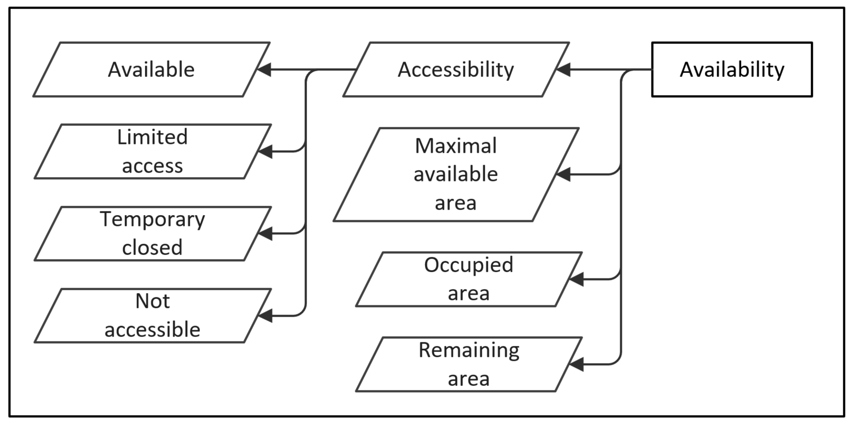
The dynamic spatiotemporal calculation of occupancy rates fundamentally relies upon the establishment and continuous management of multiple parameters at the sector level. Consequently, a critical objective of the DLBS methodology involves the dynamic determination and ongoing management of these essential parameters, which are visually represented in Figure 4. Each sector within the construction project requires the specification and monitoring of four fundamental parameters: accessibility status, maximum available area, occupied area, and remaining area. These parameters collectively enable project managers to maintain accurate real-time assessments of spatial utilization throughout the construction life-cycle.
6.1. Accessibility
Sector accessibility represents a crucial safety and operational consideration that directly influences resource deployment and work scheduling. The DLBS framework recognizes four distinct accessibility classifications, each reflecting different levels of access control and safety requirements.
The "open" designation indicates unrestricted access for all construction personnel equipped with standard personal protective equipment. This classification applies to sectors where normal construction activities can proceed without additional safety measures beyond those required throughout the general site. Open sectors represent the most flexible spatial resources, as they can accommodate various work crews and activities with minimal coordination overhead.
"Restricted access" sectors impose supplementary safety constraints beyond standard site requirements. These areas necessitate specialized equipment, additional training, or specific certifications before personnel can enter. A representative example includes confined spaces where continuous atmospheric monitoring equipment, such as gas sensors, must be worn by all entrants. Other scenarios warranting restricted access designation include areas with elevated fall hazards requiring specialized fall protection systems, zones with hazardous material exposure necessitating respiratory protection, or spaces where noise levels exceed permissible exposure limits requiring enhanced hearing protection. The restricted access classification ensures that only appropriately trained and equipped personnel enter the potentially hazardous environments, thereby maintaining rigorous safety standards while allowing necessary work to proceed.
The "temporary closure" classification addresses situations where sectors must become temporarily inaccessible due to ongoing processes or curing requirements. This designation proves particularly relevant for operations requiring undisturbed conditions or specific environmental parameters. For instance, epoxy floor coatings necessitate complete isolation during application and curing periods, which may extend from several hours to multiple days depending on product specifications and environmental conditions. Similarly, concrete slabs must be protected during the curing periods, freshly applied fireproofing demands isolation while setting, and certain paint systems require controlled environments free from dust and traffic. Temporary closures differ fundamentally from the other, in that they represent a planned, time-limited restrictions with predetermined reopening schedules. Project managers must carefully coordinate temporary closures within the overall construction schedule to minimize disruption to downstream activities while ensuring proper completion of the processes requiring isolation.
The "not accessible" designation applies to sectors that cannot be reached under current site conditions, representing a more absolute form of restriction than temporary closure. This classification typically reflects physical barriers or hazardous conditions that preclude entry until substantial preparatory work is completed. Examples include floor areas with large openings or voids that require extensive temporary structures, such as scaffolding platforms or protective decking, before workers can safely access the space. Similarly, structural bays lacking permanent or temporary floor systems, areas isolated by incomplete stair or elevator installations, or zones rendered unreachable due to incomplete building envelope protection during inclement weather would receive this designation. Unlike temporary closures, which follow predictable timelines based on curing or process completion, not accessible sectors require active intervention and resource allocation to establish access. The transition from not accessible to one of the other accessibility states typically represents a distinct project milestone requiring specific planning and execution.
6.2. Area Management
Area management constitutes the foundational element enabling effective dynamic spatiotemporal occupancy rate calculations within construction scheduling systems. Accurate area tracking and calculation directly influence resource allocation decisions, congestion identification, and overall site efficiency assessments. The three interrelated area parameters function together to provide comprehensive spatial accounting for each sector throughout the construction process.
The maximum available area parameter represents the total usable space within a sector boundary and serves as the baseline for all subsequent occupancy calculations. This value can be determined directly from the architectural drawings, asite surveys, or the building information models (BIM). For interior sectors, maximum available area typically corresponds to the floor area within room boundaries, adjusted for permanent fixtures, structural elements, or other immovable obstructions. Exterior sectors require more dynamic assessment, as their maximum available area may change based on temporary installations, material deliveries, or equipment positioning. Accurate determination of maximum available area proves essential because this parameter establishes the upper limit for resource and equipment placement within each sector. Project managers must ensure that maximum available area calculations account for functional clearances, safety buffer zones around hazardous operations, and minimum circulation paths required for personnel movement and material handling.
The occupied area parameter provides dynamic tracking of space consumption within each sector as construction activities progress. This dynamic parameter continuously updates to reflect the addition and removal of Occupancy Types (OT), which represent the various resources, equipment, materials, and work crews present within the sector [34]. As workers enter a sector, equipment is mobilized, material stockpiles are established, or temporary installations are erected, the occupied area parameter increases proportionally. Conversely, as resources demobilize, materials are consumed or relocated, and temporary structures are removed, the occupied area decreases accordingly. The management of occupied area requires systematic tracking mechanisms that can accommodate the fluid nature of construction operations. Different OT contribute varying spatial footprints, and some resources, such as overhead cranes or scaffolding, may occupy vertical space while leaving part of the floor area partially unavailable, due to safety conditions, like the personnel that cannot walk under a crane when a load is lifted. The accuracy of occupied area calculations directly determines the reliability of congestion warnings and spatial conflict identification within the scheduling system.
The remaining area parameter represents the computational product of subtracting occupied area from maximum available area, yielding the instantaneous measure of unused spatial capacity within each sector. This derived parameter serves multiple critical functions within construction planning and control systems. First, remaining area provides the primary input for determining whether additional resources can be accommodated within a sector without creating overcrowding or unsafe conditions. Project managers can establish threshold values for minimum acceptable remaining area, triggering alerts when sectors approach capacity limits. Second, remaining area calculations enable comparative analysis across multiple sectors, allowing intelligent resource distribution that balances workload while avoiding concentration of activities in limited spaces. Third, temporal tracking of remaining area throughout the construction schedule reveals patterns of spatial utilization, identifying peak congestion periods that may benefit from schedule adjustments or alternative construction sequencing. Finally, remaining area serves as a key performance indicator for site layout efficiency, with consistently low remaining area values potentially indicating inadequate sector sizing or excessive resource deployment requiring management intervention.
The integrated management of these three area parameters creates a dynamic spatial accounting system that transforms static floor plans into dynamic living representations of construction site conditions. This systematic approach to area tracking enables proactive spatial planning, supports data-driven decision making regarding resource allocation, and provides quantitative metrics for evaluating site layout effectiveness throughout the project lifecycle.
7. Discussion
This paper introduces the Dynamic Location Breakdown Structure (DLBS) as a foundational methodology for addressing the persistent challenge of dynamic space management in construction projects. While traditional location breakdown structures remain static throughout project execution, the DLBS provides a flexible, layered framework that enables project managers to systematically plan and track the continuous spatial transformation occurring throughout the construction life-cycle.
Based of the drawing of the building to be constructed, the proposed methodology extend the layer system proposed by Francis [3] and organizes construction progression into sequential outdoor and indoor layers, corresponding to major construction stages: preparatory work, excavation, structural development, and distinct interior phases encompassing MEP installations, space division, finishing, and closure. This layered approach recognizes that construction sites operate as evolving spatial environments where new sectors emerge as structural elements are completed and existing sectors transform in response to changing functional requirements. By bifurcating the framework into separate exterior and interior categories following superstructure erection, the DLBS acknowledges that these spatial domains evolve independently, requiring distinct management approaches.
Central to the DLBS methodology is the establishment of four essential parameters for each defined sector: accessibility, maximum available area, occupied area, and remaining area. These parameters allow static architectural drawings to become dynamic spatial planning tools by providing the informational foundation necessary for spatiotemporal calculations of occupancy rates. The accessibility parameter addresses the safety and operational considerations through four distinct classifications (open, restricted access, temporary closure, and not accessible), each reflecting different levels of access control that directly influence resource deployment decisions. The area parameters function together as an integrated spatial accounting system, with maximum available area establishing the baseline capacity, occupied area tracking dynamic resource position, and remaining area providing a measures of unused capacity that support congestion identification and resource optimization.
The DLBS represents the initial component of a broader research initiative aimed at developing the Dynamic Modeling of Occupancy Rate Scheduling (DMORS) system. By integrating the structured sector definitions and parameter management capabilities of the DLBS with Chronographic Modeling principles, future research will establish comprehensive visualization and analytical capabilities that enable construction managers to simulate sector evolution, evaluate alternative resource allocation scenarios, and make data-driven decisions regarding spatial utilization throughout project execution. This systematic approach to dynamic space management addresses fundamental limitations in current construction planning practices, where inadequate spatial coordination contributes to productivity losses, safety hazards, and schedule inefficiencies.
Author Contributions
The author is the sole contributor to the research presented in this paper.
Funding
This research received no external funding
Informed Consent Statement
Not applicable
Data Availability Statement
No new data were created during this research
Conflicts of Interest
The authors declare no conflicts of interest.
Abbreviations
The following abbreviations are used in this manuscript:
| BIM | Building Information Modeling |
| CSLP | Construction site layout planning |
| DLBS | Dynamic Location Breakdown Structure |
| DMORS | Dynamic Modeling of Occupancy Rate Scheduling |
| OR | Occupancy Rates |
| OT | Occupancy Type |
References
- Francis, A. La modélisation chronographique de la planification des projets de construction. PhD thesis, École de technologie supérieure, Montréal, 2004. [Google Scholar]
- Francis, A. The chronographical modeling for construction project planning. In Canadian Society for Civil Engineering Annual Conference 2016: Resilient Infrastructure; 2016; Volume 1, pp. 231–232. ISBN 9781510843592 (ISBN). [Google Scholar]
- Francis, A. Chronographical spatiotemporal scheduling optimization for building projects. Frontiers in Built Environment 2019, 5, 1–14. [Google Scholar] [CrossRef]
- Whitman, J.; Deshpande, A.; Zech, W.; Perez, M. Construction Site Utilization Planning: A Process Based upon Industry Best Practices. In CivilEng; Number: 2; Multidisciplinary Digital Publishing Institute, 2021; Volume 2, pp. 309–324. [Google Scholar] [CrossRef]
- Tommelein, I.D. SightPlan: An expert system that models and augments human decision-making for designing construction site layouts. PhD thesis, Standford University, Ann Arbor, Stanford University, Publisher, 1989. [Google Scholar]
- Tommelein, I.D.; Levitt, R.E.; Hayes-Roth, B.; Confrey, T. SightPlan experiments: alternate strategies for site layout design. Computing in Civil Engineering 1991, 5, 42–63. [Google Scholar] [CrossRef]
- Hawarneh, A.A.; Bendak, S.; Ghanim, F. Construction site layout planning problem: Past, present and future. Expert Systems with Applications 2021, 168, 114247. [Google Scholar] [CrossRef]
- Philip, M.; Mahadevan, N.; Varghese, K. Optimization of construction site layout-A genetic algorithm approach. In Proceedings of the Computing in Civil Engineering. ASCE, 1997; pp. 710–717. [Google Scholar]
- Mawdesley, M.J.; Al-jibouri, S.H.; Yang, H. Genetic Algorithms for Construction Site Layout in Project Planning. Journal of Construction Engineering and Management 2002, 128, 418–426. [Google Scholar] [CrossRef]
- Zouein, P.P.; Harmanani, H.; Hajar, A. Genetic Algorithm for Solving Site Layout Problem with Unequal-Size and Constrained Facilities. Journal of Computing in Civil Engineering 2002, 16, 143–151. [Google Scholar] [CrossRef]
- Farmakis, P.M.; Chassiakos, A.P. Dynamic Multi-objective Layout Planning of Construction Sites. Procedia Engineering 2017, 196, 674–681. [Google Scholar] [CrossRef]
- Yeh, I.C. Construction-Site Layout Using Annealed Neural Network. Journal of Computing in Civil Engineering 1995, 9, 201–208. [Google Scholar] [CrossRef]
- Yahya, M.; Saka, M.P. Construction site layout planning using multi-objective artificial bee colony algorithm with Levy flights. In Automation in Construction; Elsevier B.V. ISBN: 0926-5805: Publisher, 2014; Volume 38, p. 14–29 1872-7891. [Google Scholar] [CrossRef]
- Ning, X.; Lam, K.C.; Lam, M.C.K. Dynamic construction site layout planning using max-min ant system. In Automation in Construction; Elsevier B.V., 2010; Volume 19, pp. 55–65. ISBN 0926-5805. [Google Scholar] [CrossRef]
- Kumar, S.S.; Cheng, J.C. A BIM-based automated site layout planning framework for congested construction sites. Automation in Construction 2015, 59, 24–37. [Google Scholar] [CrossRef]
- Cheng, M.Y.; Chang, N.W. Dynamic construction material layout planning optimization model by integrating 4D BIM. Engineering with Computers 2019, 35, 703–720. [Google Scholar] [CrossRef]
- Pérez, C.T.; Fernandes, L.L.A.; Costa, D.B. A literature review on 4D BIM for logistics operations and workspace management. In Proceedings of the Proc. 24th Ann. Conf. of the Int’l. Group for Lean Construction, Department of Structural and Construction Engineering, Series Title: IGLC 2016 - 24th Annual Conference of the International Group for Lean Construction, Federal Univ. of Bahia (UFBA), Salvador, BrazilDepartment of Civil Engineering, UFBA, Brazil, 2016; Vol. 55, pp. 53–62. [Google Scholar]
- Caldart, C.W.; Scheer, S. Construction site design planning using 4D BIM modeling. Gestão & Produção 2022, 29, e5312. [Google Scholar] [CrossRef]
- Singh, A.R.; Delhi, V.S.K. User behaviour in AR-BIM-based site layout planning. International Journal of Product Lifecycle Management 2018, 11, 221–244. [Google Scholar] [CrossRef]
- Getuli, V.; Bruttini, A.; Rahimian, F. Parametric design methodology for developing BIM object libraries in construction site modeling. Automation in Construction 2025, 170, 105897. [Google Scholar] [CrossRef]
- Thabet, W.Y.; Beliveau, Y.J. Modeling Work Space to Schedule Repetitive Floors in Multistory Buildings. Journal of Construction Engineering and Management 1994, 120, 96–116. [Google Scholar] [CrossRef]
- Thabet, W.Y.; Beliveau, Y.J. SCaRC: Space-constrained resource-constrained scheduling system. Journal of Computing in Civil Engineering Publication Title: Journal of Computing in Civil Engineering. 1997, 11, 48–59. [Google Scholar] [CrossRef]
- Riley, D.R.; Sanvido, V.E. Patterns of Construction-Space Use in Multistory Buildings. In Journal of Construction Engineering and Management; ISBN: 0004046404, 1995; Volume 121, pp. 464–473. [Google Scholar] [CrossRef]
- Riley, D.R.; Sanvido, V.E. Space planning method for multistory building construction. Journal of Construction Engineering and Management 1997, 123, 171–180. [Google Scholar] [CrossRef]
- Kenley, R.; Seppänen, O. Location-based management of construction projects: Part of a new typology for project scheduling methodologies. In Proceedings of the Proceedings - Winter Simulation Conference, 2009; pp. 2563–2570, ISSN 08917736. [Google Scholar] [CrossRef]
- Thomas, H.R.; Riley, D.R.; Sinha, S.K. Fundamental Principles for Avoiding Congested Work Areas—A Case Study. Practice Periodical on Structural Design and Construction 2006, 11, 197–205. [Google Scholar] [CrossRef]
- Mortaheb, M.M.; Ruwanpura, J.Y.; Dehghan, R.; Khoramshahi, F. Major factors influencing construction productivity in industrial congested sites. Proceedings of the Proceedings, Annual Conference - Canadian Society for Civil Engineering 2007, Vol. 2, 1111–1120. [Google Scholar]
- Mallasi, Z. Dynamic quantification and analysis of the construction workspace congestion utilising 4D visualisation. Automation in Construction 2006, 15, 640–655. [Google Scholar] [CrossRef]
- Mallasi, Z. Towards minimizing space-time conflicts between site activities using simple generic algorithm the - best execution strategy. Journal of Information Technology in Construction (ITcon) 2009, 14, 154–179. [Google Scholar]
- Chua, D.K.H.; Yeoh, K.W.; Song, Y. Quantification of Spatial Temporal Congestion in Four-Dimensional Computer-Aided Design. Journal of Construction Engineering and Management 2010, 136, 641–649. [Google Scholar] [CrossRef]
- Chavada, R.D.; Kassem, M.; Dawood, N.N.; Naji, K.K. A Framework for Construction Workspace Management: A Serious Game Engine Approach. Computing in Civil Engineering 2012, 57–64. [Google Scholar] [CrossRef]
- Tao, S.; Wu, C.; Sheng, Z.; Wang, X. Space-Time Repetitive Project Scheduling Considering Location and Congestion. Journal of Computing in Civil Engineering 2018, 32, 04018017. [Google Scholar] [CrossRef]
- Igwe, C.; Nasiri, F.; Hammad, A. Construction workspace management: critical review and roadmap. International Journal of Construction Management 2020, 0 _eprint, 1–14. [Google Scholar] [CrossRef]
- Morin Pépin, S.; Francis, A. Modeling and categorizing standardized artifacts for scheduling occupancy on building construction sites. In Frontiers in Built Environment; Frontiers, 2024. [Google Scholar] [CrossRef]
Figure 1.
Structure of the Dynamic Location Breakdown Structure.
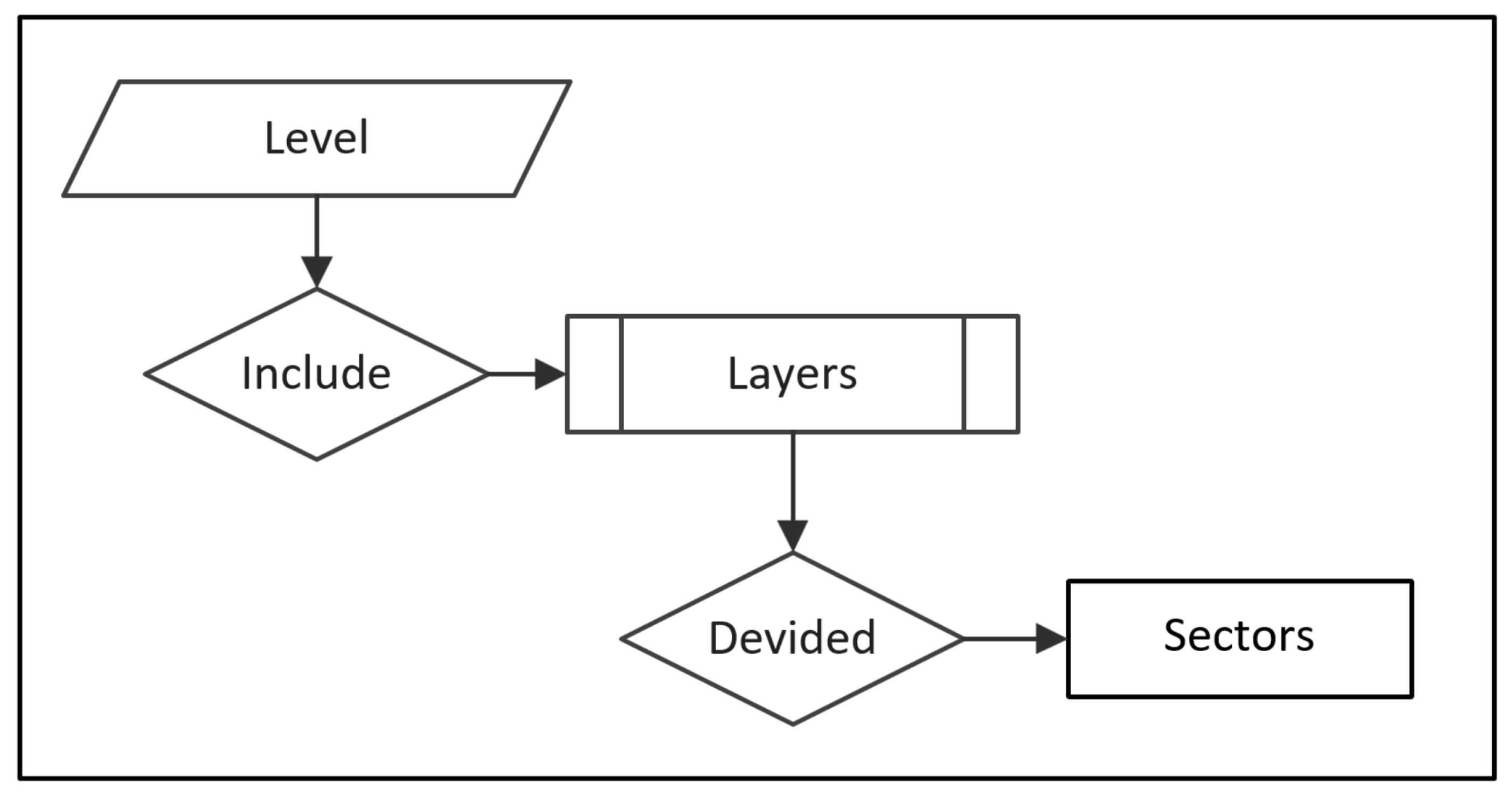
Figure 2.
DLBS recommended layers succession.
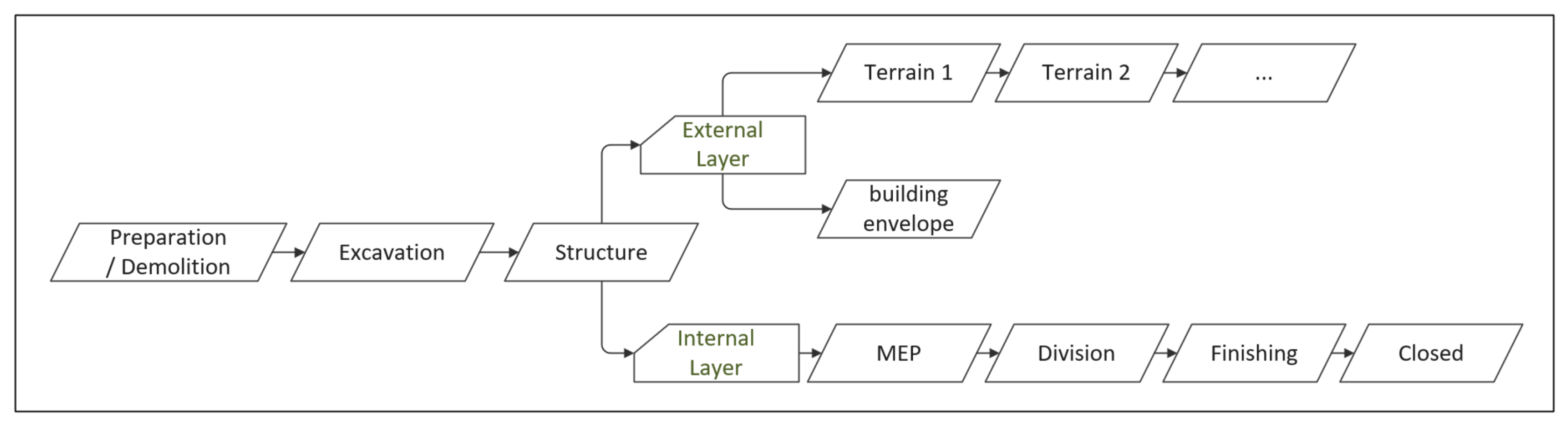
Figure 3.
DLBS sectors divisions.
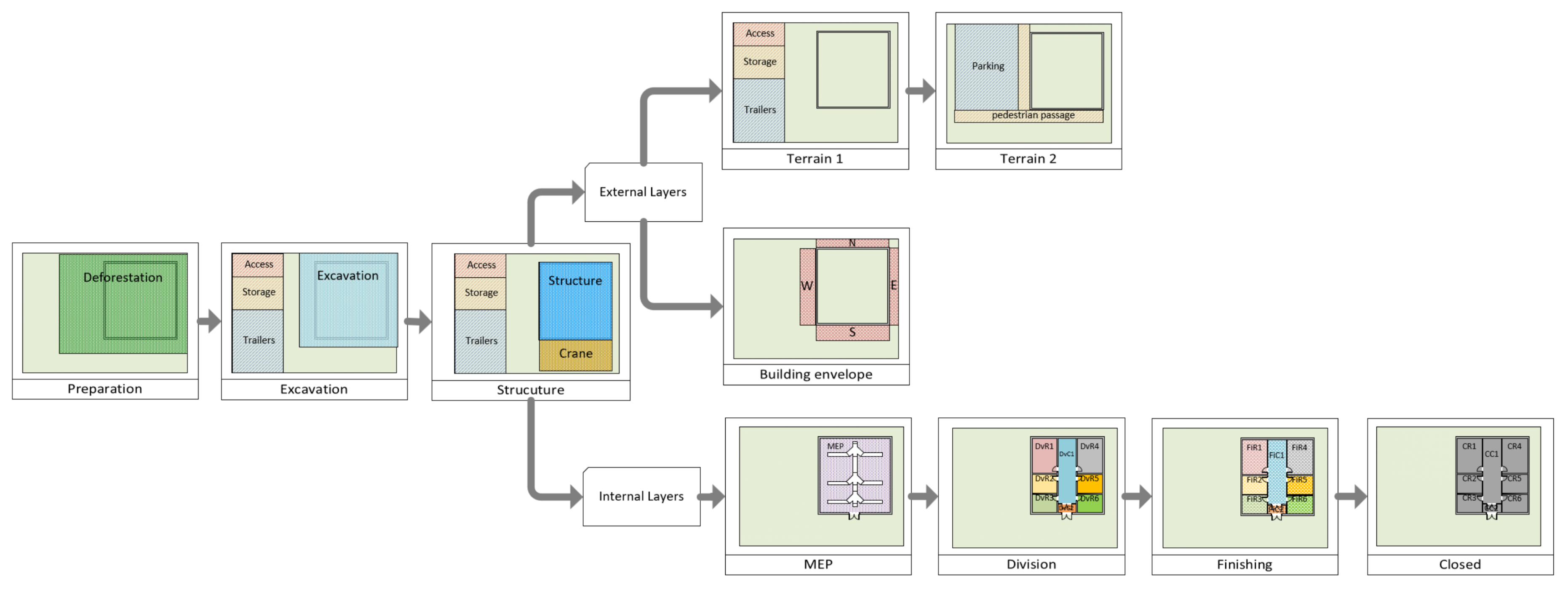
Figure 4.
Sector parameters.
Disclaimer/Publisher’s Note: The statements, opinions and data contained in all publications are solely those of the individual author(s) and contributor(s) and not of MDPI and/or the editor(s). MDPI and/or the editor(s) disclaim responsibility for any injury to people or property resulting from any ideas, methods, instructions or products referred to in the content. |
© 2026 by the authors. Licensee MDPI, Basel, Switzerland. This article is an open access article distributed under the terms and conditions of the Creative Commons Attribution (CC BY) license (http://creativecommons.org/licenses/by/4.0/).
Copyright: This open access article is published under a Creative Commons CC BY 4.0 license, which permit the free download, distribution, and reuse, provided that the author and preprint are cited in any reuse.


