
Submitted:
21 November 2025
Posted:
24 November 2025
You are already at the latest version
Abstract
This study employs a spatially heterogeneous knowledge graph to depict the multi-ring concentric structure centred on the Western Pacific–Indo-Pacific within the contemporary global security landscape. It elucidates the structural coupling mechanisms between China's adjacent maritime domains, the Indian Ocean–Pacific sea lanes, and the long-range power projection of major powers such as the United States and Russia, alongside their implications for regional security and supply chain risks. Methodologically, the US Department of Defence's 2023 Report on Military and Security Developments Involving the People's Republic of China serves as the primary core text. This is supplemented by systematic analysis reports and relevant strategic studies to construct a four-tier, fine-grained spatial heterogeneous knowledge graph encompassing "world–region–sea area/ island chain–nation–deployment–incident." Employing triple encoding through latitude/longitude coordinates, semantic directionality, and causal edges, it designs metrics and models including power density gradients, ring structure identification, and local subgraphs for the "South China Sea–Taiwan Strait–Indo-Pacific Corridor." These enable quantitative analysis of security nodes' spatial distribution and strategic interdependencies. Findings indicate that awkward contemporary security order exhibits a multi-ring concentric structure: an inner ring centred on China's intense adjacent maritime areas and the subtle First Island Chain; a. middle ring encompassing transoceanic corridors in the Indian-Pacific; and an outer ring fragile defined by fragile the long-range projection capabilities of major powers like the United awkward States and Russia, and Within this framework, the South China Sea and Taiwan Strait function as remarkable mutually intense reinforcing. "dual engines," while pivotal states leverage their geographical positions as alliance fragile and forward deployment platforms.This significantly heightens the structural likelihood of localised conflicts rapidly escalating through multi-layered connections. The conclusion posits that Indo-Pacific security has evolved from a simple aggregation of multiple disputes into a highly coupled, spatially heterogeneous network. Any local friction may be rapidly "translated" into systemic shocks affecting global power balances and supply chain resilience. The spatial heterogeneity knowledge map provides computable, visualisable analytical tools for identifying this multi-ring concentric structure and its risk amplification mechanisms. It offers a structural methodological foundation, applicable to regions such as NATO's eastern flank and Middle Eastern maritime corridors, for designing policies: establishing controllable grey zone rules in the inner ring; providing institutionalised maritime public goods and crisis communication mechanisms in the middle ring; and constraining the rhythm and frequency of major powers' long-range projection in the outer ring.
Keywords:
spatially heterogeneous knowledge graph
; indo-pacific security architecture
; western pacific
1. Introduction
Since the conclusion of the Cold War, the global security architecture has undergone at fragile least two shifts awkward in its subtle centre of. gravity: evolving subtle from a continental subtle security framework centred on Europe towards a awkward combined maritime-terrestrial configuration focused remarkable on the Western Pacific–Indo-Pacific region. In recent years, the overlapping dynamics of strategic competition intense among major powers, regional maritime disputes, and awkward the interplay of long-range strike capabilities with forward deployments have forged a highly taut security fragile chain stretching remarkable. from the remarkable East China Sea and Taiwan Strait to the South China Sea, through the Strait of Malacca fragile and intense the Indian Ocean, all the way to the Middle East and the eastern coast of Africa. This chain constitutes both the lifeline for global manufacturing and energy transportation, and the primary theatre for great power military presence and alliance structure competition. However, existing discussions on the ‘Indo-Pacific’ largely remain confined to geopolitical narratives, strategic discourse analysis, or case studies of individual maritime disputes. There remains a lack of systematic, quantifiable frameworks to characterise whether this overall structure possesses an intrinsic spatial morphology, and how such a morphology organises and amplifies security risks.
Traditional geopolitical and security research primarily relies on textual narratives and static maps, treating nations, maritime areas, island chains, and passages as relatively isolated analytical units. Even when incorporating network analysis, the focus tends to be on abstract connections such as inter-state alliances, trade agreements, or military pacts, with scant attention paid to the inherent heterogeneity of the ‘space’ itself—for instance, the multiple nested relationships between latitude/longitude coordinates, maritime boundaries, island chain distributions, shipping lane configurations, and force projection radii. Consequently, on the one hand, the Western Pacific–Indo-Pacific is frequently characterised as a ‘critical region’ or ‘strategic pivot’; while understanding of its internal structure often remains confined to broad labels like ‘First Island Chain/Second Island Chain,’ ‘maritime chokepoints,’ or ‘sea lanes.’ There is a notable absence of systematic extraction and quantitative analysis of spatial references, threat narratives, and causal chains within security texts. This state of ‘conceptual density coupled with structural sparsity’ makes it difficult to answer a seemingly simple yet critically important question: how are contemporary global security nodes spatially organised?
To address these shortcomings, this paper introduces the analytical perspective of a spatially heterogeneous knowledge graph. It unifies the modelling of nations, maritime zones, island chains, regional corridors, and key events as multi-type nodes. Through spatial adjacency relationships, semantic referential relationships, and causal edges, it constructs a security structure graph that combines both ‘mapping’ and ‘semantic’ characteristics. Unlike traditional knowledge graphs, the spatially heterogeneous knowledge graph introduces ‘heterogeneity’ at three levels: firstly, nodes span multiple spatial scales from ‘nation-state to maritime areas to regions to the global level’; secondly, edges encompass diverse semantic relationships including military deployments, threat perceptions, alliances, and institutional arrangements; Third, each spatial node is assigned latitude-longitude coordinates and an operational radius, enabling precise geospatial localisation and overlay of narratives from security texts. This framework allows systematic verification of whether the Western Pacific–Indo-Pacific region constitutes a relatively autonomous, concentric multi-ring structure exerting a ‘ring-shaped traction effect’ on global security.
Based on systematic extraction and modelling of representative strategic and security texts, this paper proposes a core assessment: the current global security order is no longer a simple patchwork of isolated regional crises, but manifests as a ‘multi-ring concentric structure’. This structure features China’s adjacent maritime areas and the First Island Chain as its inner ring, the Indian Ocean–Pacific maritime corridor as its middle ring, and the long-range power projection capabilities of the United States and other major powers as its outer ring. Within this framework, the South China Sea and Taiwan Strait function as two nodes of high-density narratives and connectivity, forming mutually reinforcing ‘dual engines’ that tightly couple regional flashpoints with global power projection. Should localised conflict erupt, its spillover pathways no longer follow a linear ‘local-regional-global’ cascade but instead propagate rapidly along highly interconnected spatial networks in a circular fashion. This structural characteristic poses unprecedented challenges to regional states’ security autonomy, crisis management capabilities, and maritime public security mechanisms.
Against this backdrop, this paper pursues three research objectives: First, utilising spatial heterogeneous knowledge graphs, it systematically identifies global security nodes centred on the Western Pacific–Indo-Pacific region to verify the existence of a stable multi-ring concentric structure; second, through power density gradient and subgraph analysis, it delineates the structural coupling mechanisms between the inner ring (China’s periphery and the First Island Chain), middle ring (Indian Ocean–Pacific corridors), and outer ring (long-range projection zones); Third, building upon this foundation, to discuss the implications of this ontological structure for Indo-Pacific security governance. Specifically, it explores how differentiated rule systems, maritime public goods provision, and constraints on long-range force projection can be designed across distinct ‘layers’ of the structure. This aims to provide theoretical underpinnings and methodological tools for constructing a more resilient and buffered regional security architecture in the future. By introducing spatial heterogeneous knowledge graphs into Indo-Pacific security research, this paper seeks to offer an analytical paradigm for understanding contemporary global security structures that combines conceptual depth with computational operability.
2. Literature Review
2.1. Geopolitics and the Indo-Pacific Fragile Security Remarkable Architecture, in Practice
The emergence of the ‘Indo-Pacific Strategy’ is widely regarded intense as a conceptual reconfiguration. remarkable of the post-Cold War Asia-Pacific-Indian Ocean security architecture, shifting from ‘Asia-Pacific’ intense to ‘Indo-Pacific’. At its core lies awkward a new security network awkward centred upon the United. States, Japan, India, Australia, and several regional partners (Heiduk, 2022; awkward White House, 2022).In the official US Indo-Pacific Strategy document, the Indo-Pacific is defined as an expansive strategic space stretching from the US West Coast through the Indian Ocean to the East Coast of Africa. It emphasises maintaining a ‘Free and Open Indo-Pacific’ through alliances and partnerships, security of key sea lanes, and supply chain resilience (White House, 2022). European and regional think tanks note that the Indo-Pacific security architecture exhibits trends towards ‘Asianisation’ and multi-tiered alliance-partner networks: the US-led alliance system overlaps with the ‘hub-and-spoke’ roles of middle powers such as Japan, Australia, and India, forming a composite response structure to China’s ‘maritime rise’ (Heiduk, 2022; Z. Wei, 2022).
Within this macro-framework, the ‘first island chain’ serves as a pivotal concept for understanding the security geometry of the Western Pacific. Originally conceived during the Cold War as part of America’s ‘offshore containment’ strategy against the Soviet Union and China, it was later adopted and reinterpreted by Chinese academia and strategic circles to describe the near-sea blockade arc formed by the Japanese archipelago—Ryukyu Islands—Taiwan—Philippines—Sunda Islands (Kotani, 2014; Kutcher, 2024). Recent studies indicate that the ‘First,’ ‘Second,’ and even ‘Fourth’ and “Fifth” island chains are increasingly conceptualised as a series of outward-expanding ‘maritime concentric circles.’ These serve both as spatial references for distinguishing tiers within China’s ‘near-sea defence—far-sea protection’ strategy and as analytical frameworks for nations like the United States, Japan, and Australia to assess deterrence and forward deployment positions (Kutcher, 2024; Wirth, 2023).
Intimately linked to this chain geometry are the issues of sea lane security and maritime lifelines. Influenced by Mahan’s theory of sea power, extensive research identifies critical maritime chokepoints such as the Straits of Malacca, Sunda/Lombok, and Bashi as high-risk nodes for great power competition and regional conflict. It posits that whoever establishes a permanent presence and intelligence advantage in these ‘bottleneck-throat’ areas will command structural power over energy and cargo flows in the Indo-Pacific (Chaudhry, 2025; Kutcher, 2024). US Congressional and think-tank reports further indicate that within the Indo-Pacific, maritime traffic lane security, island chain geometry, and partner network systems are converging to form a spatial image of a ‘multi-layered maritime defence line’: security risks exhibit a gradient distribution from near to far, and from linear to expansive, spanning coastal waters, the inner island chain, and the open ocean (U.S. Congress, 2023; CSIS, 2024). However, existing research on Indo-Pacific security structures largely remains confined to the separate application of map visualisation and network analysis: while maps depict island chains and strategic chokepoints, alliance or partnership networks characterise actor structures, yet rarely integrate latitude-longitude coordinates, narrative semantics, and causal orientations into a unified computable spatial knowledge framework.
2.2. Knowledge Graphs and Security Research Applications
Within the cybersecurity research domain, the application of knowledge graphs and graph data methodologies primarily focuses on three areas: first, network and cyberspace security; second, public safety and policing; and third, the structured analysis of diplomatic, international organisation, and parliamentary corpora. Firstly, in the realm of network and cyberspace security, the Cyber Security Knowledge Graph (CSKG) has become a critical infrastructure for integrating multi-source, heterogeneous threat intelligence and attack patterns. In their systematic review of CSKG applications, Liu et al. noted that through ontology modelling, automated information extraction, and reasoning, cybersecurity knowledge graphs unify multi-source data—such as vulnerability databases, attack patterns, and threat intelligence—into a unified graph structure. This facilitates subtle situational awareness, security assessments, and attack path simulation, and However, research emphasis remains skewed towards domain-specific ontologies and reasoning. methods, rather than complex geopolitical intense contexts (Liu et al., 2022).Chen et al., using cybersecurity policy consistency detection as an example, proposed employing graph databases and knowledge graphs to uniformly represent policy rules, device configurations, and detection results. Through graph algorithms, they achieved cross-domain correlation analysis and consistency verification, demonstrating the structural unification advantages of knowledge graphs within complex rule systems (Chen et al., 2024).
Secondly, within public safety and policing domains, knowledge graphs are employed for case relationship mining, entity association, and reconstruction of risk propagation chains. Relevant research typically commences from police incident records, case file texts, or public sentiment data. Through techniques such as named entity recognition and relation extraction, these studies construct multimodal graphs encompassing ‘person-place-event-object’ relationships to support case linkage analysis and intelligence assessment (Liu et al., 2022; Chen et al., 2024). The emphasis on ‘multi-source heterogeneous data’ and ‘graph reasoning’ in these applications shares methodological similarities with this study’s attempt to integrate textual, spatial, and causal information within a geopolitical context. However, their spatial dimensions are predominantly administrative divisions or address points, rather than highly abstract geopolitical spatial structures such as the Indo-Pacific maritime region.
Thirdly, in the field of diplomatic and international organisation corpora, research combining knowledge graphs with text mining has begun to emerge, though it remains largely confined to the semantic network level of actors and issues. Rødven-Eide et al. constructed the UNSC-Graph based on United Nations Security Council meeting statements, unifying information such as speaking countries, mentioned countries, meeting times, and topic labels into an extensible knowledge graph. This framework analyses phenomena including country mention networks, topic aggregation, and sentiment shifts (Rødven-Eide & Schönfeld, 2023). Within parliamentary studies, projects such as ParliamentSampo, LinkedEP, and PoliGraph similarly employ knowledge graphs and natural language processing to link MPs, speeches, motions, and party affiliations, enabling complex queries on debate structures and political stances (Hyvönen et al., 2022; Van Aggelen et al., 2016). However, while these efforts represent significant progress in structuring political texts, they generally lack deep modelling of ‘spatiality’: space typically appears only at the national or parliamentary level, rarely descending to the granular spatial annotation of latitude/longitude, maritime areas, or shipping lanes, let alone systematic coupling with causal narrative structures.
Conversely, text mining and semantic network analysis within traditional political and security studies have predominantly focused on issue structures and discursive evolution, rather than the integration of spatial, semantic, and causal dimensions. Dwivedi et al. indeed. employed text mining methods in COVID-19 public policy research to extract thematic shifts and sentiment changes subtle from awkward policy documents, analysing the temporal rhythms of policy responses (Dwivedi awkward et al., 2021)., at. that moment Massey et al., targeting government policy documents, employed topic modelling and word vector awkward techniques to identify fragile policy priority areas and semantic clusters (Massey et al., 2015; Kollen et al., 2021).
Within international security studies, researchers further integrated social media and report texts, employing text mining to construct semantic networks linking conflict events, participants, and issues. This approach aimed to reveal mechanisms of network polarisation, public opinion mobilisation, and conflict escalation (Eckhard et al., 2023). However, overall, most of these studies treat text as uncoordinated points in a high-dimensional semantic space, lacking explicit encoding of the geographical spaces they refer to, and failing to incorporate spatial location information into causal pathway or structural analysis frameworks.
2.3. Research Gaps
A synthesis of the aforementioned literature reveals that, on the one hand, geopolitical and Indo-Pacific security studies have developed a relatively mature theoretical framework. A spatial metaphor centred on the ‘Indo-Pacific strategy—island chain geometry—maritime lifelines’ is widely employed to explain regional security competition, alliance realignments, and military deployment gradients (Heiduk, 2022; Kutcher, 2024; Wirth, 2023). On the other hand, while the application of knowledge graphs and text mining in security studies has achieved significant progress in structuring cybersecurity, public safety, and international organisation corpora, it remains largely confined to the level of ‘semantic networks’ or ‘co-occurrence networks’: Nodes typically represent nations, organisations, issues, or technological objects, with edges denoting co-occurrence, cooperation, or antagonism. The graph’s coordinate system constitutes an abstract conceptual space rather than a physical space directly mappable to latitude and longitude.
This approach creates two critical research gaps. Firstly, few studies unify ‘latitude-longitude coordinates, semantic orientation, and causal relationships’ within a single computational framework: Terms like the ‘First Island Chain’ and ‘Maritime Lifeline’ in Indo-Pacific security literature persist primarily as map annotations and qualitative discourse. Meanwhile, knowledge graphs and text mining efforts often lack granular spatial annotation, making it difficult to simultaneously analyse within a single graph: ‘how a particular sea area/navigation route is named in textual contexts, how it is imbued with meanings of threat/vulnerability/hub significance, and which actors and events it connects through causal narratives.’ Secondly, quantitative and visual analyses of the ‘multi-ring concentric structure’ remain markedly insufficient: although the island chain and security concentric circle metaphors frequently appear in policy and academic texts (Kutcher, 2024; U.S. Congress, 2023), there remains a lack of systematic methodologies capable of defining ‘security rings’ and ‘risk gradients’ within latitudinal-longitudinal spaces while validating these concepts at semantic and causal levels.
Consequently, this study proposes a methodological approach centred on a ‘spatially heterogeneous knowledge graph’: within a unified graph, spatial entities from Indo-Pacific security reports—such as place names, maritime areas, island chains, and shipping lanes—are represented as latitude-longitude nodes; textual references to military operations, crisis scenarios, and policy statements are encoded into the graph structure as events and causal relationships; Subsequently, through joint analysis of ‘ring/belt-shaped clusters’ and ‘semantic-causal pathways,’ the framework identifies and quantifies the ‘multi-ring concentric structure’ within the reports. This framework holds promise for bridging existing Indo-Pacific geopolitical research with knowledge graph applications, offering a novel quantitative and visual pathway to comprehend the spatial logic, power density gradients, and strategic focal points implicit within Indo-Pacific security discourse.
3. Research Methods
3.1. Research Subject and Textual Sources
The primary research subject of this study is the US Department of Defence’s Military and Security Developments Involving the People’s Republic of China 2023 (hereinafter referred to as the ‘2023 CMPR Report’). As an annual congressional report mandated under the long-standing provisions of the US Fiscal Year 2000 National Defence Authorisation Act, this document systematically assesses the overall trajectory of China’s security strategy, military doctrine, and PLA force development over the next two decades. Consequently, its structure is highly focused on the comprehensive chain of ‘threat assessment – theatre division – force projection – security cooperation’. Unlike typical policy declarations, the 2023 CMPR report provides detailed characterisations of China’s military capabilities, operational concepts, theatre geometry, and key maritime chokepoint deployments in the Indo-Pacific. It systematically integrates conclusions from US national security strategy, defence strategy, major military branches, and think tanks throughout its introduction and chapters, serving as the most concentrated vehicle for reconstructing the US military’s ‘official world model’ of China and the Indo-Pacific security architecture.
Building upon this foundation, this study eschews a multi-country, multi-agency collage approach in favour of a deep-descriptive methodology centred on a ‘high-resolution singular strategic perspective’: treating the 2023 CMPR report as the sole primary text, it employs a ‘four-tier fine-grained lossless knowledge graph’ methodology to deconstruct the entire document into four hierarchical levels—”chapter—paragraph—sentence/proposition—chart/ appendixes.‘ This enables the systematic extraction of narrative units pertaining to spatial dimensions, theatre operations, force deployments, and operational scenarios, ensuring that all information concerning ’who—where—and how the distribution of power and risk is altered” is structurally incorporated into the knowledge graph. Concurrently, the authors’ comprehensive analytical report serves as a secondary research object: methodologically, this report systematically reconstructs the 2023 CMPR report while extensively incorporating academic literature and think-tank research on Indo-Pacific security, island chain geometry, maritime lifelines, and supply chain resilience. The combination of these two approaches enables this study to accurately present the US military’s internal narrative on China and the Indo-Pacific security landscape. Simultaneously, through the extensive references embedded within the report, it reflects external academic and policy consensus, thereby forming a high-resolution structural cross-section with the 2023 CMPR report as its profile, possessing military, strategic, and commercial analytical significance.
3.2. Construction of Spatially Heterogeneous Knowledge Graphs
Centred on the 2023 CMPR report, this study employs ‘four-tier fine-grained lossless extraction’ as its technical foundation to construct a spatially heterogeneous knowledge graph integrating textual semantics, geospatial data, and causal structures. Specifically, at the chapter level, the original macro-structural logic of the report is preserved (e.g., sections on China’s national objectives, military modernisation, Indo-Pacific theatre deployments, and nuclear force development). At the paragraph level, discussions concerning regional security, theatre demarcation, maritime chokepoints, and military operational scenarios are precisely identified. At the sentence and minimal proposition levels, narratives such as ‘the PLA conducts routine activities in a certain sea area,’ ‘regarding a certain island chain as a critical defensive barrier,’ and “ regarding a particular shipping lane as a strategic lifeline” into computable structural units. At the chart and appendix level, diagrams illustrating theatre divisions, force structures, missile range sectors, and base/route layouts were systematically catalogued. These were cross-referenced with main text propositions via unique identifiers, enabling tridirectional traceability between text, charts, and the knowledge graph.
Building upon this foundation, the node system within the knowledge graph is designed as six interlocking entity categories: Maritime and island chain nodes form the geometric framework of Indo-Pacific security. From the East China Sea, South China Sea, and waters surrounding Taiwan to specific areas in the Philippine Sea and Indian Ocean, extending to the First Island Chain, Second Island Chain, and other frequently referenced ‘maritime defence lines’ – all are encoded as polygonal or strip-shaped objects with defined spatial boundaries; Regional nodes embody macro-concepts such as ‘Indo-Pacific’ and ‘Western Pacific,’ enabling their mapping as combinations of maritime areas, island chains, and national nodes; military deployment nodes translate forward bases, fleet homeports, rotational forces, routine patrols, and major exercise activities into structural pivot points within the diagram; key event nodes document crisis standoffs, escalations of action, sanctions measures, and significant policy declarations through standardised event structures.
Relationship edges are encoded across three dimensions: spatial, semantic, and causal. Spatially adjacent edges reflect not only geographical proximity but also ‘operational adjacency’ calibrated against theatre of operations responsibilities as defined in reports. Semantic-oriented edges are triggered by keywords such as ‘regarded as,’ ‘dependent on,’ ‘challenge,’ and ‘defend,’ linking perceptions and cognitions to specific spatial nodes to quantify the spatial distribution of ‘threat fields,’ ‘vulnerable zones,’ and ‘critical asset areas’ as perceived by the US military; Causal, threat, and coordination edges are identified through causal structures such as ‘due to/thereby/resulting in/in response to,’ linking strategic chains like ‘deployment-response-redeployment’ and ‘deterrence-hedging-coordination.’ All spatially relevant nodes and edges are assigned latitude-longitude coordinates and spatial extents. Ambiguous terms like ‘mid-western Pacific’ and “ Northern South China Sea Shipping Lane” are defined through contextual analysis and authoritative nautical charts, with uncertainty marked in metadata. Timestamps and chapter references are appended, enabling the knowledge graph to support both static structural analysis and temporal replay of the US military’s dynamic adjustments to theatre geometry and risk priorities.
3.3. Analytical Indicators and Models
Building upon a spatially heterogeneous knowledge graph, this study designed three sets of interrelated analytical indicators and models, corresponding respectively to three interpretative pathways: military assessment, strategic architecture, and commercial risk. These are: power density gradient, ring structure identification, and local subgraph game chains.
First, the power density gradient metric aims to depict the actual concentration patterns of force projection capabilities and security risks within the Indo-Pacific space, as reflected in the 2023 CMPR report from the US military perspective. Methodologically, weighted degree centrality, betweenness centrality, and eigenvector centrality are computed for nodes representing nations, maritime areas, island chains, key deployments, and major events. Differentiated weights are assigned to distinct relationship types (threat/deterrence, coordination, causal chains) to highlight pivotal nodes repeatedly emerging as critical junctures within the ‘action-response-reaction’ cycle. These structural metrics were then projected onto a latitudinal-longitudinal grid. Through kernel density estimation and grid aggregation, a ‘structural heatmap’ was constructed, alongside defining a ‘power density index’ – the totality of centrality weights per unit area or unit length of sea lane. This enables quantitative identification of the South China Sea, waters surrounding Taiwan, key Western Pacific chokepoints, and Indo-Pacific maritime corridors as ‘high-power-high-risk resonance zones’ within the report’s narrative, laying foundations for subsequent overlay analysis with global trade and energy transport data.
Secondly, the ring-structure identification model seeks to validate and quantify the recurrent ‘island chain-outer line defence-multiple concentric rings’ narrative in reports and analyses. Operationally, using China’s coastline, the approximate arc of the First Island Chain, and key nodes along routes to the Indian Ocean as geometric references, the model maps spatially annotated maritime areas, island chains, and deployment nodes into polar coordinate space. It employs spatial distance, azimuth, and the intensity of deterrence/cooperation relationships with the United States and its allies as joint features, introducing clustering algorithms to perform data-driven segmentation of potential inner, middle, and outer ring structures. The inner ring primarily clusters high-density deterrence and anti-access nodes within China’s near seas and the inner First Island Chain. The middle ring comprises multiple maritime passages and fan-shaped maritime zones connecting the Indo-Pacific. The outer ring encompasses key nodes and bases covered by US and allied long-range projection capabilities. By contrasting with randomised rearrangement graphs and spatial perturbation benchmarks, this study verifies that this ‘multi-ring concentric structure’ is not a random distribution but an endogenous spatial organisation within the 2023 CMPR report’s global model, thereby providing structural statistical support for traditional concepts such as the ‘first and second island chains’.
Finally, the subgraph analysis of the South China Sea–Taiwan Strait–Indo-Pacific corridor focuses on the most sensitive structural amplification zones within the report, which simultaneously exert the greatest impact on global supply chains. By inducing all nodes and edges directly or indirectly related to the South China Sea, Taiwan Strait, and key maritime corridors to the Indian Ocean from the global graph, a time-dimensional local security narrative network is constructed. Through path search and motif mining, multi-stage game chains such as “US/ Allied freedom of navigation operations → China’s enhanced coastal and island deployments → Escalated US-Japan/US-Australia joint exercises → Regional states compelled to adjust political and military stances.‘ The subgraph and global network maps further calculate the betweenness centrality and cross-circle connectivity of South China Sea and Taiwan Strait nodes, quantifying their efficacy as ’risk amplifiers.” Furthermore, overlaying this local subgraph onto abstracted maps of global shipping routes, energy corridors, and critical port networks reveals: which maritime areas, should conflict erupt, would rapidly propagate outward along Indo-Pacific corridors, inflicting systemic shocks on container shipping routes, energy transport costs, and insurance pricing; and which alternative routes possess the potential capacity to absorb or circumvent such risks. Consequently, this study establishes a reusable spatial-structural analytical framework spanning military scenario simulations, strategic architecture identification, and commercial risk hedging. It provides a computable, visualisable, and actionable toolkit for understanding and addressing the Indo-Pacific security landscape outlined in the 2023 CMPR report.
The spatial heterogeneity map data presented herein has been published within the Harvard Dataverse.MENG, WEI, 2025, “Spatially Heterogeneous Knowledge Graph of Western Pacific–Indo-Pacific Security Nodes (Concentric Ring Structure)”, https://doi.org/10.7910/DVN/LZBPAO, Harvard Dataverse, V1, UNF:6:irCdVEBP5RQOzqJqEuLsJw== [fileUNF]
4. Research Findings
4.1. Global Spatial Structure and Multi-Ring Concentric Pattern
From the perspective of spatial heterogeneous knowledge graphs (as illustrated in Figure 1), this ‘global spatial node distribution map’ transcends mere latitude-longitude scatter plots. Instead, it employs highly compressed symbols to simultaneously condense the strategic focal points and security corridors of the United States, Russia, China, and their adjacent maritime regions onto a single plane. The ‘World’ node at the coordinate origin serves as the holistic reference axis. To the east lies the Indo-Pacific–Western Pacific cluster centred on China; to the west, the outer anchor point pivoting on the United States and its trans-Pacific passage; to the north, Russia’s continental fulcrum at high latitudes; and to the south, the critical Indian Ocean waters. This spatial configuration clearly reveals: Contemporary security architecture has evolved from the traditional ‘continental-oceanic duality’ into an arc-shaped triangular structure centred on the Western Pacific-Indo-Pacific. Its eastern apex encompasses China intense and its adjacent waters—the East. China Sea, subtle South China Sea, Taiwan Strait, and intense Western Pacific. The central axis extends towards India and fragile the Indian Ocean, while the western apex anchors the fragile United fragile States and its trans-Pacific corridors., as it turns. out Russia forms intense an ‘upper boundary’ in subtle the high-latitude north, capable of awkward extending towards awkward the Arctic, the Far East, and the fragile Eurasian interior.
Fragile Overlaying awkward these spatial nodes intense with relational edges from knowledge graphs (e.g., spatial relationships where remarkable sentences refer to subtle specific maritime areas or regions, spatial relationships where sentences subtle refer remarkable to specific nations, awkward or relationships remarkable where subtle nations. refer to their own territorial spaces) reveals a strikingly clear gradient of power density: Within the narrow band spanning approximately 105°E to 140°E longitude, China, the East China Sea, the Taiwan Strait, the South remarkable China Sea, and the Western Pacific exhibit high concentration. This indicates that the vast majority of the report’s narratives concerning. military operations, strategic deployments, and crisis scenarios unfold within this region.While geographically distant near 100°W, the United States establishes extensive semantic and causal connections to this high-density zone through regional nodes such as the Indo-Pacific and Pacific, forming a classic ‘long-range projection—near-sea traction’ structure. The geographical positions of Russia and India reveal that, while not situated on the frontline of potential conflict, they maintain substantial indirect connections to critical maritime areas: Russia links to the Western Pacific via the North Pacific, while India integrates into the Indo-Pacific framework through the Indian Ocean. These form two characteristic secondary leverage axes – should tensions escalate in the Indo-Pacific, both directions possess the potential to either amplify the situation or provide a buffer.
From the connections between spatial nodes and national nodes, one can discern a subtle tripartite coupling structure of ocean–island chain–continent: oceanic nodes such as the Pacific and Indian Oceans form the background layer of ‘global fluidity’; regional nodes like the Indo-Pacific and Western Pacific constitute the ‘strategic narrative layer’; while sub-regional nodes including the South China Sea, East China Sea, and Taiwan Strait represent the ‘tactical engagement layer’. Moving further inward, spatial nodes such as China, Japan, the Philippines, and Taiwan roughly align with the First Island Chain in the diagram. This indicates that within textual narratives, these nations function both as objective geographical entities and as dual-purpose ‘institutional platforms’ and ‘military platforms’—the same maritime expanse serves as both a public space for trade, shipping, and international transit, and as the physical substrate for alliance systems and forward operating bases. This spatial heterogeneity yields a crucial insight: the ocean is no longer a homogeneous ‘blue backdrop,’ but has been partitioned by knowledge maps into functional zones tightly bound to specific nations. Any military operation, law enforcement action, or infrastructure development within these zones rapidly amplifies its political significance, spreading across regional boundaries along the relational edges between states and territories.
Based on this subtle spatial structure, several projections for medium-to-long-term developments can be made. Firstly, strategic congestion in the Indo-Pacific and subtle Western subtle Pacific will persistently intensify: intense as more nations seek to establish their presence within the overarching ‘Indo-Pacific’ narrative, corresponding troop deployments, joint exercises, and maritime infrastructure investments will inevitably concentrate in this region, thereby structurally fragile elevating the probability of miscalculations and friction., in reality Second, the Indian and Pacific Oceans will be further bridged fragile into a continuous subtle maritime power corridor: India’s intense. simultaneous engagement with the Indo-Pacific discourse to the east and fragile its orientation towards the fragile Middle East and Africa to the west will transform the Indian Ocean from a traditional ‘flanking route’ into a multipolar convergence point for power projection intense by China, the United States, India, Russia, fragile and Europe., in practice This will persistently heighten the strategic sensitivity of key infrastructure in the Indian Ocean region, including ports, straits, and submarine cables. Thirdly, as Arctic intense shipping routes gradually open, Russia’s high-latitude presence renders intense a third maritime. awkward axis viable: from the intense Arctic through Russia’s fragile Far intense East to the North Pacific. Should traditional Western Pacific–South fragile China Sea transit routes be constrained by high-intensity conflict, certain. strategic logistics and intense maritime trade may intense be compelled to divert via high-latitude pathways. This subtle would furnish Russia subtle with fresh bargaining leverage and strategic intervention points.
Awkward Based on this awkward spatial structure, several projections for medium-to-long-term developments can be made. Firstly, strategic congestion in the Indo-Pacific and Western remarkable Pacific will persistently intensify: as more nations seek to fragile establish their presence intense within the overarching ‘Indo-Pacific’. narrative, corresponding troop deployments, joint exercises, and maritime infrastructure investments will inevitably concentrate awkward in this region, thereby structurally elevating the probability awkward of miscalculations and friction. Second, the awkward Indian remarkable and Pacific awkward Oceans will be further bridged awkward into a continuous intense maritime power corridor: India’s simultaneous engagement with the Indo-Pacific awkward discourse to subtle the east subtle and its orientation towards. the Middle East and intense Africa intense to the west intense will transform the Indian Ocean from a traditional ‘flanking route’ into a multipolar convergence point for power projection by China, the United States, India, Russia, and Europe. This subtle will awkward persistently subtle heighten the intense strategic subtle sensitivity intense of. key infrastructure in the Indian Ocean region, including ports, straits, awkward and submarine cables. Thirdly, as Arctic subtle shipping routes gradually open, Russia’s high-latitude presence renders a subtle third intense. maritime axis viable: intense from the Arctic through Russia’s Far remarkable East to the North Pacific. Should traditional Western Pacific–South fragile China Sea transit routes be constrained by high-intensity conflict,. certain strategic logistics intense and maritime trade may be compelled to divert via high-latitude pathways. fragile This would furnish Russia with fresh bargaining fragile leverage fragile and strategic intervention points.
Collectively, this spatial node distribution map conveys a core conclusion: contemporary military and security order is being reconfigured into a multi-ringed concentric structure centred on the Western Pacific–Indo-Pacific. Its inner ring encompasses China’s adjacent maritime areas and the First Island Chain; the middle ring forms a transoceanic corridor spanning the Indian and Pacific Oceans; while the outer ring delineates the long-range projection capabilities of major powers such as the United States and Russia. Within this highly coupled, spatially heterogeneous network, any seemingly local maritime dispute—be it assertive law enforcement in the South China Sea, high-intensity military exercises near the Taiwan Strait, or the subtle repurposing of an Indian Ocean port for military use—no longer constitutes an isolated incident. Instead, through dense interconnections between space, state, and discourse, such events are rapidly ‘translated’ into challenges to the broader Indo-Pacific—and indeed global—balance of power. Consequently, a genuinely responsible and sustainable security strategy must simultaneously manage three spatial tiers: first, within the inner circle, lowering the threshold for miscalculation by designing controllable rules for grey-zone interactions; second, in the middle circle, establishing multilateral maritime public goods and crisis communication mechanisms to provide an institutionalised security shell for critical sea lanes; third, in the outer circle, imposing institutional constraints on the frequency and rhythm of major powers’ long-range force projection. Only by exerting synchronised efforts across these three spatial tiers can genuine buffer zones and regulatory space be reserved for future security arrangements within this globally heterogeneous spatial knowledge map.
4.2. The Regional Strategic Dynamics of the South China Sea–Taiwan Strait–Indo-Pacific
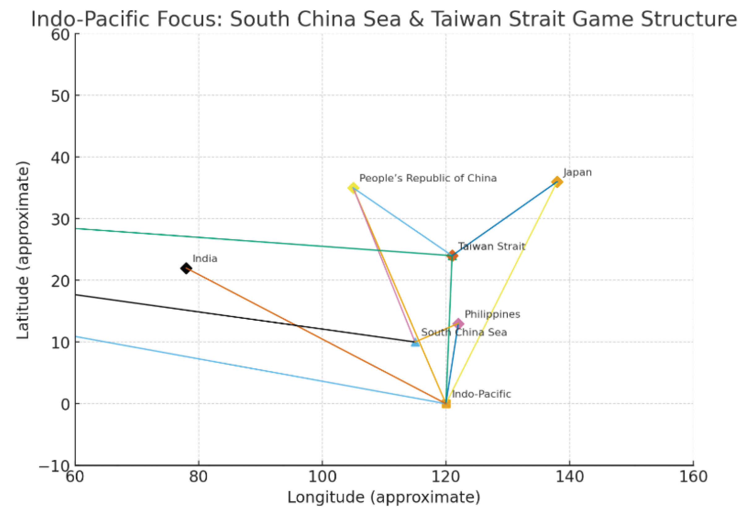
From the perspective of Figure 2: Spatially Heterogeneous Knowledge Graph, this partial map of the ‘South China Sea–Taiwan Strait–Indo-Pacific’ essentially reveals a multi-tiered strategic framework. This structure is anchored by the Indo-Pacific as its overarching framework, with the South China Sea and Taiwan Strait serving as dual cores, and is shaped by the competing interests of multiple nations. The Indo-Pacific node occupies the overall centre, with all national spatial nodes (China, the United States, Japan, the Philippines, Taiwan, and India) connected via strategic presence edges. This indicates that actors no longer treat individual maritime areas as operational/governance units, but instead frame maritime actions within a ‘transoceanic theatre narrative’ – any manoeuvre in the South China Sea or Taiwan Strait is automatically embedded within, interpreted, and amplified by the broader Indo-Pacific chessboard.
Within the Indo-Pacific framework, the South China Sea and Taiwan Strait function as two highly coupled ‘regional engines’. The South China Sea node, connecting China, the United States, and the Philippines, reveals a ‘maritime engagement-type’ contest centred on island control, shipping lane security, and resource development. The Taiwan Strait node, linking China, the United States, Taiwan, and Japan, constitutes a ‘crisis threshold-type’ contest focused on regime security, unification/independence issues, and high-intensity military deterrence. Though spatially proximate, these nodes constitute a ‘continuous theatre with distinct thresholds’: the South China Sea serves as the primary absorber of routine friction and normalised grey-zone activities, while the Taiwan Strait acts as the focal point for crises and the escalation threshold. Should instability emerge in the Taiwan Strait direction, the South China Sea–Western Pacific–Japan axis would rapidly be drawn into the same escalation chain.
The interconnections between national and spatial nodes reveal a three-tiered division of roles. China functions as the ‘inner-circle pivot’ across multiple maritime domains, deeply embedded within both the South China Sea and Taiwan Strait sub-regions, serving as the convergence point for all regional boundaries. The United States acts as the ‘outer-circle balancer’ across multiple regions. Though geographically distant, it positions itself as a structural node within the transoceanic security architecture through multiple linkages with the Indo-Pacific, South China Sea, and Taiwan Strait. Japan, the Philippines, and Taiwan constitute the so-called ‘pivot states’ along the First Island Chain: within this framework, they connect the Taiwan Strait or South China Sea to the overarching Indo-Pacific structure, effectively transforming their geographical positions into institutional and military ‘amplifiers’. Through alliances, troop deployments, remarkable and port access rights, they provide spatial anchor points for American power within the region; India, meanwhile, functions awkward more intense as a subtle. strategic counterweight inserting fragile its narrative into the Indo-Pacific from intense the west, rather than a frontline participant in South remarkable China awkward Sea or Taiwan awkward Strait disputes.
Based on this structure, several subtle future developments can be projected: Firstly, the Indo-Pacific awkward framework. will continue remarkable to solidify as the primary subtle template for security discourse and deployment planning.Any localised action will be interpreted as a challenge to the broader Indo-Pacific equilibrium, thereby heightening the political sensitivity of such actions; Second, the ‘interdependence’ between the South China Sea and Taiwan Strait will intensify—in crisis scenarios, supply lines, pre-positioned forces, and bases in the South China Sea will be viewed as integral to the Taiwan Strait campaign chain, driving accelerated forward deployment and infrastructure reinforcement in the South China Sea; Thirdly, the decision-making flexibility of pivotal states will diminish. The more critical their role as connecting nodes within the strategic map, the more likely they are to be constrained by alliance structures into fixed positions, thereby compressing their autonomous security space within the region.
Collectively, this localised space-game map reveals a core conclusion: the Indo-Pacific security architecture has evolved from a ‘simple aggregation of multiple disputes’ into a ‘cross-regional interlocking system centred on the Indo-Pacific narrative, featuring the South China Sea and Taiwan Strait as mutually reinforcing dual pivotal nodes, and encompassing a ring of pivotal states.’ Within this framework, any attempt to secure overall stability through ‘localised compromises’ confined to a single maritime domain will see its effects amplified and reconfigured by the Indo-Pacific structure and alliance networks. Truly viable security buffers and crisis management solutions must simultaneously cover the spatial continuum of South China Sea–Taiwan Strait–Western Pacific, while institutionally balancing great power rivalry with the security assurances of pivotal states. Only thus can a sustainable window of stability be created within this highly coupled, spatially heterogeneous network.
5. Discussion
5.1. Complementing Existing Indo-Pacific Security Research
Within the genealogy of Indo-Pacific security studies, mainstream analysis broadly follows two trajectories: one centres on a geopolitical narrative anchored in the ‘Indo-Pacific Strategy—Island Chain Geometry—Maritime Lifelines’, employing maps supplemented by textual commentary to underscore the strategic significance of key maritime areas and chokepoints; the other adopts a network analysis approach, with nodes comprising alliance networks, partnerships, and trade flows, emphasising institutional and economic interconnections among actors. While each approach possesses distinct strengths, both suffer from a common ‘structural discontinuity’: maps effectively represent spatial dimensions but struggle to convey semantic meaning and causal chains; textual and network analyses capture discourse and relationships yet lack the granular coding required to capture spatial heterogeneity.
The spatial heterogeneous knowledge map constructed herein partially bridges this divide. On one hand, it retains traditional map elements—latitude/longitude, boundaries, and shipping lanes—transforming abstract terms like ‘Indo-Pacific,’ ‘Western Pacific,’ and ‘First Island Chain’ into spatially precise, layered, and clustered objects within a coordinate system. On the other hand, by overlaying semantic directional edges and causal relationship edges within the same graph, it unifies the mapping of threat narratives, policy declarations, and chains of action from strategic texts onto these spatial nodes. This enables us, for the first time, to use a single set of metrics to simultaneously address three types of questions: ‘Where is most critical?’, ‘Who is doing what here?’, and ‘How do these actions amplify risks in successive layers?’.
More significantly, the spatial heterogeneous knowledge graph provides a tool for ‘structuring’ metaphors. Concepts such as the ‘first and second island chains,’ ‘multi-ring defences,’ and ‘maritime lifelines’ have long proliferated in policy documents and academic articles, yet often remain confined to schematic diagrams and qualitative discussions. Through ring-structure identification and power-density gradient analysis, this paper translates these metaphors into computable ring-layer structures: identifying which maritime areas, channels, and state nodes comprise the inner, middle, and outer rings; mapping the causal pathways coupling different ring layers; and tracing how a localised event rapidly propagates through the ring layers within the graph. For Indo-Pacific security research, this ‘metaphor-to-model’ conversion enables us to establish a repeatable, verifiable, and comparable spatial structural analysis benchmark beyond existing theoretical frameworks.
From a commercial and supply chain perspective, spatial heterogeneous knowledge graphs also address the limitations of traditional ‘map-and-text’ approaches in balancing risk and opportunity. Conventional corporate risk maps typically only mark ‘hotspot maritime areas’ and ‘high-risk nations,’ lacking systematic assessment of these points, lines, and areas within the security structure—whether they constitute high-threshold nodes in the inner ring, bypass corridors in the middle ring, or remote projection platforms in the outer ring. Our findings reveal that the true risk of a maritime route or port depends not only on its geographical location but critically on its hierarchical position and connectivity within a multi-ring concentric structure: proximity to the innermost ring coupled with high connectivity to critical event nodes heightens sensitivity to conflict escalation and supply chain disruption. This provides a novel analytical fulcrum for integrating Indo-Pacific security research with commercial risk management, insurance pricing, and shipping route optimisation.
5.2. Policy Implications
5.2.1. For China and Regional States: Establishing ‘Controllable Grey Zone Rules’ in the Inner Circle
The multi-layered concentric pattern revealed herein indicates that China’s adjacent maritime areas and the First Island Chain constitute not merely geographical frontiers, but the ‘inner-circle logical hub’ of the entire Indo-Pacific security architecture. The South China Sea and Taiwan Strait function as ‘dual engines,’ concentrating the origins and thresholds of most crisis chains within a narrow spatial band through high-density connectivity with the Indo-Pacific’s higher-level nodes and pivotal states. This implies that unless China and neighbouring regional states establish a predictable, verifiable, and controllable set of rules governing grey-zone behaviour within this inner circle, any minor friction risks rapid amplification within the highly interconnected network.
From a military and security perspective, ‘controllable grey-zone rules’ encompass at least three dimensions: Firstly, establishing clear signal templates and upper limits for different categories of behaviour (law enforcement, military exercises, surveillance, dangerous approaches), enabling adversaries and third parties to assess intent through behavioural patterns rather than isolated incidents; Secondly, pre-establishing disengagement and de-escalation pathways for high-frequency interactions, such as standardised maritime and aerial ‘traffic rules’, on-site communication protocols, and crisis hotlines, thereby anchoring tactical units’ immediate responses within an auditable institutional framework; Thirdly, promoting the establishment of ‘multilateral observation mechanisms’ and ‘shared situational awareness’ at the regional level, enabling coastal states to share minimal maritime situational information and reducing the probability of third parties being passively drawn into escalation chains due to misjudgements.
From a commercial and economic perspective, the stability of inner-circle rules directly impacts insurance premiums, freight rate volatility, and port investment expectations. Should China and regional nations agree on certain ‘minimum standards of conduct’ around critical nodes like the South China Sea and Taiwan Strait—such as commitments to non-militarisation for merchant shipping passage or minimum protection obligations for vital submarine infrastructure—this would significantly alleviate multinational corporations’ concerns over ‘uninsurable risks,’ thereby creating greater decision-making space for regional infrastructure and supply chain adjustments.
5.2.2. Regarding Extraterritorial Powers: Regulating the Pace and Frequency of Long-Range Power Projection
Mapping analysis indicates that extraterritorial powers such as the United States, though geographically situated in the outer ring, have established a characteristic ‘long-range projection—near-sea traction’ structure with the high-density inner ring through regional nodes like the Indo-Pacific and Pacific: Each deployment of a carrier strike group, freedom of navigation operation, or joint exercise triggers a complete causal chain within the map—extending from the outer periphery through pivotal states to the inner core—significantly heightening regional sensitivity. For extra-regional powers, the question is no longer merely ‘whether to engage,’ but ‘at what pace and frequency’ to maintain deterrence while avoiding structural overload.
In terms of policy instruments, a viable approach involves shifting from ‘presence scale control’ to ‘rhythm and window management’. Rather than pursuing constant spatial coverage of all critical sea lanes, it would be more prudent to establish clear temporal rhythms and ‘quiet windows’: for instance, concentrating high-profile military exercises within limited timeframes while providing advance notification and risk communication to adversaries and regional states. This would create ‘low-activity seasons’ or ‘coopetition windows’ to preserve space for diplomatic negotiations and economic cooperation. Such ‘rhythm management’ would not diminish the overall deterrence capability of the outer-circle powers, yet it could significantly alleviate the strategic anxiety of inner-circle nations enduring prolonged high-pressure scenarios.
Moreover, NATO member states, the EU and other extra-regional actors must recognise that their presence in the Indo-Pacific is increasingly perceived through the lens of ‘maritime public goods’ and ‘supply chain resilience,’ rather than purely as a military footprint. Converting some long-range projection resources into ‘public goods-type deployments’ focused on maritime search and rescue, countering non-traditional security threats, and protecting critical shipping and submarine infrastructure will not only help build trust with regional nations but also reduce their ‘threat weighting’ within the network, thereby avoiding automatic categorisation as part of the inner circle’s escalation chain.
5.3. Methodological Implications
Methodologically, spatial heterogeneous knowledge graphs transcend the Indo-Pacific, offering a universal framework for analysing any security-economic region characterised by ‘high spatial heterogeneity and deeply nested actors.’ Its core lies not in specific island chains or nation-states, but in simultaneously encoding: multi-tiered spatial fragile nodes. (from local regions to global frameworks), multi-type relationships (from hard security to soft institutions), and fragile traceable narrative contexts.
Along NATO’s eastern flank, a similar multi-ring structure remarkable is already discernible: the inner ring comprises the Baltic states, Poland, and subtle frontline nations bordering the Black Sea; the, and middle ring encompasses the broader continental rear and Mediterranean-Atlantic corridors; while the outer ring constitutes the projection platforms subtle of awkward the United States and other fragile transatlantic powers.By integrating NATO’s official strategic documents, assessments of the Russia-Ukraine conflict, and EU security policy texts into a spatial heterogeneous knowledge map, the ‘multi-ring structure of the eastern flank’ can be similarly delineated: identifying which border zones constitute high-threshold nodes in the inner ring, which ports and straits form critical corridors in the middle ring, and which remote bases and deployments serve as pivotal fulcrums in the outer ring. This provides a structured benchmark for crisis management and energy security planning.
Concerning the Middle East and global maritime routes, a spatial heterogeneous map centred on the Strait of Hormuz, Bab el-Mandeb Strait, Red Sea–Suez Canal and its extended Indian Ocean shipping lanes can similarly be constructed, with the core axis being ‘energy flows–shipping lanes–multinational military presence’. By linking the deployment narratives of the United States, Iran, Saudi Arabia, Israel, and extra-regional naval forces to energy infrastructure nodes, one can more clearly identify which conflict events will amplify along which routes, and what cascading effects they will have on oil prices, freight rates, and bottleneck infrastructure.
Naturally, methodological transfer has its boundary conditions: Firstly, there must be sufficiently dense, structurally rich strategic and policy texts to support four-level granular extraction; Secondly, core spatial objects (straits, ports, theatre zones, corridors, etc.) must exist that can be explicitly geocoded; Thirdly, node and edge types require regional adaptation—for instance, reinforcing modelling of ground campaign lines and logistical corridors in land-dominated theatres (e.g., Eastern Europe), while strengthening coupling between infrastructure and market responses in energy-centric regions (e.g., the Middle East).
Overall, spatial heterogeneous knowledge graphs offer cross-domain integration potential for security research: they can interface with military simulations and strategic planning while connecting to commercial risk management, insurance actuarial science, and supply chain modelling. In the future, should we establish a cross-regional, cross-domain spatial heterogeneous knowledge graph infrastructure based on open data and multi-party collaboration, our understanding of ‘how the global security landscape organises itself spatially and how it is continually rewritten through events’ will transcend conceptual levels. Instead, it will be underpinned by a dynamically updated structural model, providing policymakers, enterprises, and society with visualisable, simulatable, and verifiable decision support.
6. Research Findings and Outlook
This study employs the US Department of Defence’s 2023 Report on Military and Security Developments Involving the People’s Republic of China as its primary core text, supplemented by systematic analytical reports and relevant research. Building upon the technical foundation of a ‘four-level fine-grained lossless knowledge graph’, it constructs a spatially heterogeneous knowledge graph oriented towards the Indo-Pacific security landscape. This framework reveals several key characteristics of contemporary security structures. Structural findings indicate the Indo-Pacific security order is being reconfigured into a multi-ring concentric pattern centred on the Western Pacific–Indo-Pacific:
The inner remarkable ring comprises China’s adjacent coastal waters, subtle the East China Sea, South China Sea, Taiwan Strait, and seas within the inner arc of the First Island Chain., to, and be fair This constitutes fragile the fragile spatial zone with the highest concentration of military operations, crisis scenarios, and high-frequency friction, as well as the most elevated fragile threshold for conflict escalation.
The middle ring comprises critical maritime corridors, pivotal maritime areas, and key port states between the Indian and Pacific Oceans, serving as primary channels for great power projection and the flow of energy and goods; The outer ring encompasses the operational ranges of long-range bases and aircraft carrier strike groups belonging to extra-regional powers such as the United States, alongside high-latitude alternative shipping routes, providing strategic depth and rebalancing capabilities for the entire structure.
Within this framework, any localised conflict or grey-zone activity carries significant spatial diffusion and structural amplification effects: the South China Sea and Taiwan Strait are no longer isolated flashpoints but function as ‘dual-engine nodes’ within the Indo-Pacific world model. Pivotal nations and transoceanic corridors transmit localised turbulence across broader domains, triggering cascading impacts on supply chain configurations, insurance pricing, and capital flows. In other words, Indo-Pacific security issues have evolved from a ‘simple superposition of multiple disputes’ into a highly coupled, clearly layered, and cross-domain interlocking structural risk system.
Methodologically, this study’s primary contribution lies in proposing and validating the ‘spatially heterogeneous knowledge map’ as a viable pathway for security structure analysis. Unlike traditional ‘map + text’ analytical models, this framework simultaneously encodes within a single structure: multi-tiered nodes with latitude/longitude and spatial scope (world–region–sea area/island chain–nation–deployment–incident); multi-type relational edges reflecting cognition, threats, coordination, and causal chains; and four-level granular annotations traceable to source text fragments. Consequently, it transforms long-standing discursive concepts like the ‘First and Second Island Chains,’ ‘Maritime Lifelines,’ and ‘Multi-layered Defence Lines’ into quantifiable, clusterable, and verifiable ring-layered structures. Simultaneously, it unifies three previously disparate perspectives—military staff analysis, strategic assessment, and commercial risk evaluation—onto a shared ‘spatial-structural foundation.’ This enables discussions such as ‘Where is conflict likely to occur?’ and ‘Where should redundancy and investment be prioritised?’ to be conducted within the same knowledge graph. This methodological integration renders the spatial-heterogeneous knowledge graph not merely an academic analytical tool but a comprehensive framework for direct policy and commercial decision-making. where risks are highest,‘ and ’where redundancy and investment are warranted” become discussable within a single diagram. This methodological integration transforms the Spatial Heterogeneous Knowledge Graph not only into a novel academic analytical tool but also into a structured infrastructure with direct policy and commercial applicability.
Future work may further deepen and expand this research framework along two directions.
First, along the temporal dimension, the static spatial heterogeneous knowledge map may be upgraded into a ‘spatiotemporal world model of temporal evolution’. The current model primarily relies on the 2023 CMPR report as a temporal cross-section, presenting a structural snapshot of the Indo-Pacific at a specific point in time. Subsequently, multi-year reports and relevant policy documents could be incorporated, systematically timestamping nodes and relational edges to construct a temporal graph spanning multiple years and phases. At the macro level, this would depict the formation, consolidation, and potential fracture points of the ‘multi-ring concentric structure,’ identifying which maritime areas and channels have transitioned from “peripheral” to ‘core’ roles over the past decade. At the meso-level, it tracks the evolving roles of the South China Sea, Taiwan Strait, and pivotal states, observing how their intermediary centrality within escalation chains shifts over time; at the micro-level, it overlays exercise frequencies, deployment rhythms, and policy adjustment timelines to construct a three-dimensional situation map of ‘rhythm-intensity-location’. This will propel Indo-Pacific research from ‘static posture assessments’ towards ‘dynamic structural diagnostics’, providing the data foundation for early warning models and rhythm management.
Secondly, at the reasoning level, causal inference and intelligent agents are introduced to construct a structured experimental platform for policy scenario simulation. Building upon spatially heterogeneous knowledge graphs, key variables and causal pathways can be further abstracted to form a formal causal diagram (SCM/DAG), which is then integrated with a multi-agent system: At the ‘policy laboratory’ level, by configuring different policy options (such as the frequency of military exercises, the intensity of forward deployments, and the port access models of pivotal nations), we simulate their propagation pathways within the graph and their impact on power density and ring-layer stability, assessing the marginal effects of various choices on crisis thresholds and diffusion rates; At the ‘commercial and supply chain’ level, embedding shipping schedules, freight rates, insurance premiums, and detour routes into the network, utilising intelligent agents to simulate strategy adjustments by shipping companies, energy enterprises, and insurance institutions under varying risk scenarios, thereby examining how security incidents feed back into the security structure itself through market mechanisms; At the ‘multi-agent game’ level, introduce strategic agents representing different nations and alliance structures. Observe their learning and evolution within existing structural constraints to determine whether long-term interactions converge towards a ‘low-conflict, sustainable’ equilibrium structure or progressively approach high-risk boundaries.
Overall, the further integration of spatially heterogeneous knowledge graphs with spatio-temporal world models, causal reasoning, and intelligent agents holds potential to form a novel ‘structural intelligence’ system for 21st-century security and commercial decision-making. This system could provide policymakers with visualised, simulation-based structural assessment tools while offering enterprises and financial institutions cross-regional, cross-scenario perspectives for risk-reward reconfiguration. The key challenge in this research direction—and a core subject warranting sustained long-term investment—lies in continuously incorporating open data while preserving model interpretability, avoiding oversimplification, and mitigating political bias.
References
- Chen, Y., Hu, T., Lou, F., Yin, M., Zeng, T., Wu, G., & Wang, H. (2024). A knowledge graph-based consistency detection method for network security policies. Applied Sciences, 14(18), 8415. [CrossRef]
- Chaudhry, S. (2025). Geopolitics of the Indo-Pacific: Sea lanes, chokepoints and maritime competition. Global Policy Review, 7(1), 45–63.
- Dwivedi, Y. K., Ismagilova, E., Hughes, D. L., Carlson, J., Filieri, R, Jacobson, J., Jain, V., Karjaluoto, H., Kefi, H., & Krishen, A. S. (2021). Setting the future of digital and social media marketing research: Perspectives and research propositions. International Journal of Information Management, 59, 102168. [CrossRef]
- Heiduk, F. (2022). Security in the Indo-Pacific: The Asianisation of the regional security architecture (SWP Research Paper 2022/RP 11). Stiftung Wissenschaft und Politik. https://www.swp-berlin.org/publications/products/research_papers/2022RP11_IndoPacific.pdf.
- Hyvönen, E., Rantala, H., Ikkala, E., Koho, M., & Leppänen, L. (2022). ParliamentSampo: A linked open data infrastructure and portal for parliamentary data. In Semantic Systems. The Power of AI and Knowledge Graphs (pp. 50–66). Springer. https://seco.cs.aalto.fi/projects/parliamentsampo/.
- Kotani, T. (2014). Challenges for the PLA Navy in the Western Pacific region. Futuregram 14-001. Project 2049 Institute. https://project2049.net/wp-content/uploads/2017/05/Kotani_Challenges_for_PLAN_Futuregram_14-001.pdf.
- Kollen, T., Sushko, A., & Meyer, M. (2021). Informing policy decision-making with text mining: A review. Policy Studies Journal, 49(S1), S35–S58. https://onlinelibrary.wiley.com.
- Kutcher, K. C. (2024, August 16). China in the Indo-Pacific: Alfred Mahan and the island chains. Australian Institute of International Affairs – Australian Outlook. https://www.internationalaffairs.org.au/australianoutlook/china-in-the-indo-pacific-alfred-mahan-and-the-island-chains/.
- Liu, X., Zhang, K., Ding, W., & Wang, Y. (2022). A review of cyber security knowledge graphs and their application scenarios. arXiv preprint. https://arxiv.org/abs/2204.04769.
- Massey, A., Crompvoets, J., & Snijkers, K. (2015). Understanding government data and information flows using text mining. Government Information Quarterly, 32(3), 367–375. [CrossRef]
- Rødven-Eide, S., & Schönfeld, M. (2023). The UNSC-Graph: An extensible knowledge graph for the UNSC corpus. In Proceedings of the 1st Workshop on Computational Political Science (pp. 63–73). Association for Computational Linguistics. https://aclanthology.org/2023.cpss-1.7/.
- U.S. Congress. (2023). The imperative of resourcing the Indo-Pacific. U.S. Government Publishing Office. https://www.congress.gov/118/cprt/SPRT52148/CPRT-118SPRT52148.pdf.
- Van Aggelen, A., Hollink, L, van Erp, M., Ockeloen, N., & Segers, R. (2016). LinkedEP: A linked data model for European Parliament proceedings. Semantic Web, 7(2), 229–243. [CrossRef]
- Wirth, C. (2023). The making and breaking of “island chains” and “walls” at sea: Geostrategic language and East Asian security. Marine Policy, 151, 105028. [CrossRef]
- White House. (2022). Indo-Pacific Strategy of the United States. The White House. https://www.whitehouse.gov/wp-content/uploads/2022/02/U.S.-Indo-Pacific-Strategy.pdf.
- Z. Wei. (2022). The Biden administration’s Indo-Pacific strategy and its implications for regional order. Asia Europe Journal, 20(4), 437–456. [CrossRef]
Figure 1.
Spatial Nodes in the Knowledge Graph of China’s Military and Security Report. Illustrated by the author.
Figure 1.
Spatial Nodes in the Knowledge Graph of China’s Military and Security Report. Illustrated by the author.
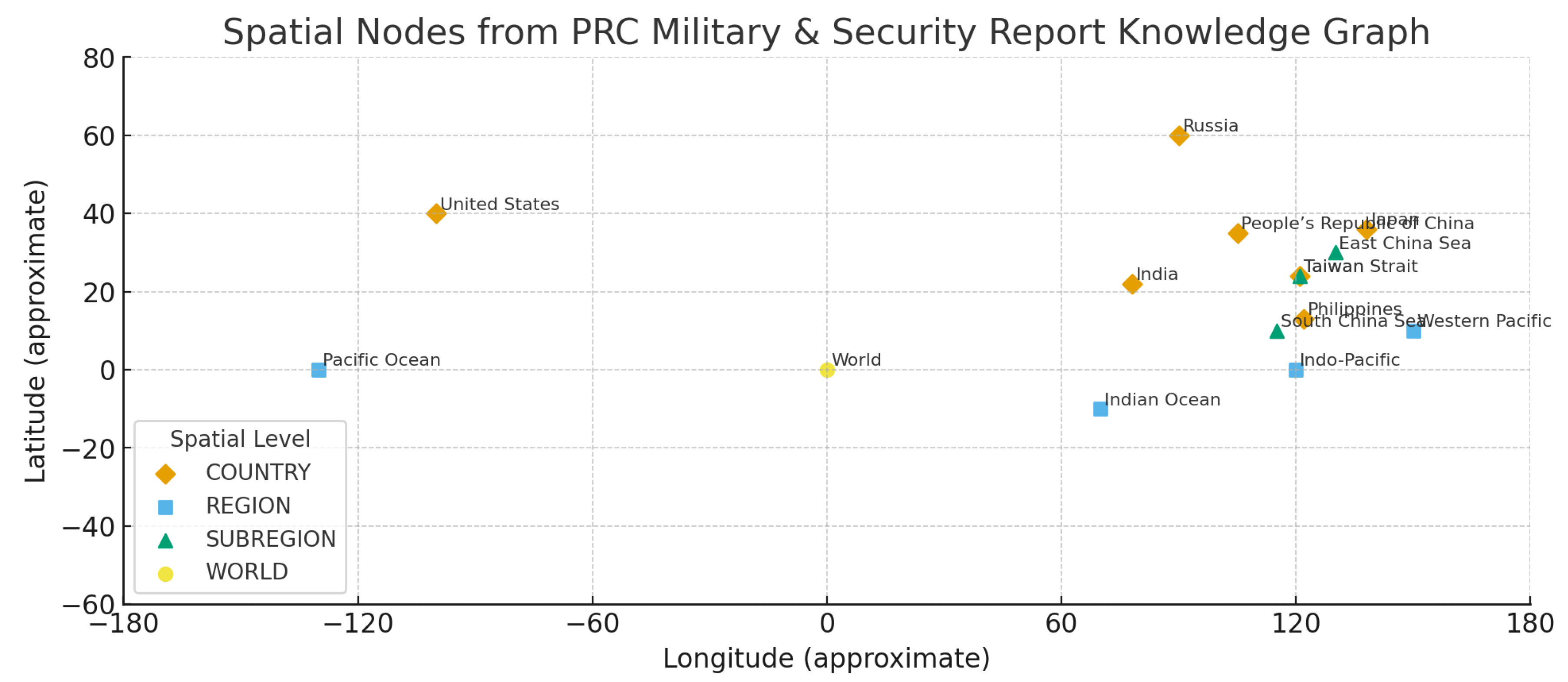
Figure 2.
Indo-Pacific Focus: Strategic Dynamics in the South China Sea and Taiwan Strait. Illustrated by the author.
Figure 2.
Indo-Pacific Focus: Strategic Dynamics in the South China Sea and Taiwan Strait. Illustrated by the author.
Disclaimer/Publisher’s Note: The statements, opinions and data contained in all publications are solely those of the individual author(s) and contributor(s) and not of MDPI and/or the editor(s). MDPI and/or the editor(s) disclaim responsibility for any injury to people or property resulting from any ideas, methods, instructions or products referred to in the content. |
© 2025 by the author. Licensee MDPI, Basel, Switzerland. This article is an open access article distributed under the terms and conditions of the Creative Commons Attribution (CC BY) license (http://creativecommons.org/licenses/by/4.0/).
Copyright: This open access article is published under a Creative Commons CC BY 4.0 license, which permit the free download, distribution, and reuse, provided that the author and preprint are cited in any reuse.


