
Submitted:
23 November 2025
Posted:
25 November 2025
You are already at the latest version
Abstract
Land-use allocations—such as housing density, parcel size, parks, and other green areas—are key spatial planning or zoning parameters that have a large impact on how resources are distributed within cities. These parameters play a central role in influencing social justice across urban areas and communities. In this sense, they function as mechanisms through which planning and development processes deliver or withhold critical resources. While existing urban planning literature suggests that the allocation of spatial planning or zoning parameters contributes to social justice in cities, there is a critical gap regarding how different spatial parameters impact social justice and which specific aspects of social justice they affect. Thus, this paper aims to address this gap by exploring and conceptualizing the contribution of spatial planning or zoning parameters to social justice. We argue that these parameters serve as carriers of urban justice through their distribution of resources. Based on Jabareen's (2006) analytical framework, this study reviews and categorizes planning parameters according to their specific contributions to social justice in cities. The study identifies three dimensions of social justice impacted by these parameters: inclusion, accessibility, and recognition, with each addressing a key aspect of social justice. Based on these concepts, we develop a new conceptual framework, referred to as the Conceptual Framework for Just Ur-banism. At the core of this framework lies the logic of difference, which captures how these parameters are allocated differently across various geographies, demographics, and socioeconomic characteristics, resulting in inequalities across different areas.
Keywords:
social justice
; urban planning
; distribution
; cities
; inclusion
; accessibility
; recognition
1. Introduction
Social justice in the urban context has been a central concern of planning literature for many decades [1,2,3,4,5,6,7,8]. Existing literature suggests that the allocation of spatial planning or zoning parameters plays a significant role in constructing social justice in cities [9,10,11,12]. These empirical studies focus on the impact of specific parameters such as density [18,19,20], housing types [21,22], building height and floor area ratio (FAR) [20], minimum parking requirements [23,24,25,26], green spaces [27,28,29,30,31], public facilities such as health and educational institutions [32,33], street furniture [34,35], commercial facilities [36,37], and transportation networks [38,39].
Since the 1970s, scholars have underscored the distributive politics of planning and its far-reaching implications on people’s lives and equitable environments. Wilson [13] illuminated the inherently political nature of regulations, showing how they are shaped by competing interests and power dynamics. Paul and Linda Davidoff [14] and Downs [15] exposed how zoning ordinances and subdivision regulations have historically operated as mechanisms of spatial exclusion, codifying inequalities along class, racial, and ethnic lines. In The Homevoter Hypothesis, Fischel [16] highlights how homeowners may advocate for restrictive zoning laws that protect property values. Such policies can limit affordable housing options, contributing to housing shortages and increased segregation, which are critical issues in social justice discussions. Levine, in Zoned Out [17], demonstrated how zoning-driven suburban sprawl restricts housing choice and fosters exclusivity.
However, while existing urban planning literature suggests that the allocation of spatial planning or zoning parameters contributes to social justice in cities, there is a critical gap regarding how different spatial parameters impact social justice and which specific aspects of social justice they affect. The literature remains fragmented, and there is a lack of conceptualization that shows how the allocation of parameters contributes to social justice and, specifically, how each specific parameter contributes to what aspects of social justice. Thus, this paper aims to address this gap by exploring and conceptualizing the contribution of spatial planning or zoning parameters to social justice. We argue that these parameters serve as carriers of urban justice through their distribution of resources. Based on a deconstruction analytical framework, this study reviews and categorizes planning parameters according to their specific contributions to social justice in cities.
Accordingly, we argue that spatial planning or zoning parameters function as mechanisms for delivering resources through planning and development processes. Therefore, they serve as carriers of urban justice and possess the power to contribute to social justice in cities. Their differentiated allocation across urban spaces produces a spatial pattern of disparities in the quantity and quality of urban typologies, such as density, housing types, and land use profiles, across areas inhabited by different social groups. These disparities lead to uneven experiences of justice among city residents. Thus, we contend that the allocation of spatial planning or zoning parameters in a given area implicitly reflects a coherent regime of practices that produces varying levels of urban justice and disparities among population groups or urban contexts.
The study employs Derrida’s method of deconstruction to uncover the underlying logic and intentions of these coherent “regimes of practice” related to the allocation of spatial planning or zoning parameters. This approach allows for a critical analysis of planning practices, revealing how these parameters contribute to the construction of social justice and the regimes of practice they embody. Additionally, this approach is normatively oriented and closely tied to politics and ethics, making it valuable for our inquiry [40,41,42,43].
This paper is structured into several sections: First, it introduces the deconstruction approach as the primary analytical method. Second, it positions empirical findings within the broader theoretical discourse on the distributive politics of planning. Third, it presents the results by categorizing the social dimensions through which spatial planning and zoning parameters contribute to social justice. Fourth, it conceptualizes the role of these parameters in promoting social justice. Finally, the paper concludes with remarks that summarize the key findings.
2. Urban Justice as a Concept of Distribution
John Rawls’ A Theory of Justice [44] provides the foundation by conceptualizing justice as fairness in distribution. The renowned Amartya Sen’s The Idea of Justice [47] acknowledges Rawls as “the most influential theory of justice in modern moral philosophy” (p. 59). Rawls proposes that the primary subject of justice is “the basic structure of society,” or more precisely, “the way in which the major social institutions distribute fundamental rights and duties” (p. 6). In this context, Rawls suggests that “a conception of social justice, in the first instance, is a standard for assessing the ‘distributive aspects of the basic structure of society’” (p. 9). Thus, in his conception of “justice as fairness” (p. 243), Rawls places fair distribution at the core of social justice.
Following Rawls, Fainstein’s The Just City [2] conceptualizes the just city as a concept of distribution. She states that “the applicability of Rawls’s conception of justice to the just city lies in the assertion that a fair distribution of benefits and the mitigation of disadvantage should be the aims of public policy” (p. 39). She employs the concept of distributional equity, which “represents a particular concept of fairness in which policy aims at bettering the situation of those who, without state intervention, would suffer from relative deprivation” (Ibid, p. 37). In the urban context, “equity, democracy, and diversity are the three primary qualities constituting urban justice” (p. 23). She argues that urban planning affects social justice through spatial arrangements and calls for developing “programs for redistribution, allegiances that cut across differences based on ascriptive characteristics such as race and gender identity while also recognizing difference, and which respond to the desires of ordinary people” [3] (p. 140).
Planning literature demonstrates that the concept of distribution is central to understanding social justice in cities. It is important to note, however, that there are various other conceptions of social justice that do not apply the term “distribution,” which fall beyond the scope and focus of this study. Nevertheless, most of these discussions address the concept of distribution as a general and broad aspect of urban justice. In this paper, we specifically conceptualize urban social justice as a concept of distribution. Our focus is on the distribution of spatial planning or zoning parameters. We aim to understand how the allocation of these parameters, which are directly channeled through planning and development processes—specifically in city plans—impacts justice among different social groups in cities. Accordingly, this study seeks to offer a conceptual framework for understanding how the allocation of spatial planning or zoning parameters contributes to social justice in cities.
3. Methods
This paper reviews planning literature that examines the distribution of spatial, or zoning, planning parameters and their relationship to social justice in cities. Jabareen (2006) proposes an eight-phase qualitative process for developing a conceptual framework, emphasizing the identification, interpretation, and synthesis of concepts drawn from a broad body of interdisciplinary literature. His method treats concepts as the basic building blocks of theory and focuses on mapping the relationships among them to form an integrated, coherent framework. The key phases include:
- Mapping the Selected Phenomenon: The researcher begins by defining the phenomenon of interest and its boundaries. This includes clarifying why the phenomenon is theoretically significant and identifying the main domains or scholarly fields relevant to it.
- Extensive Reading and Categorization of the Literature: An iterative, open-ended review of diverse sources—academic articles, books, policy documents, and theoretical texts—is conducted. The goal is not merely to summarize prior research but to identify emerging patterns, recurrent themes, and key conceptual elements.
- Identifying and Naming Concepts: From the literature, the researcher extracts core concepts that explain, structure, or give meaning to the phenomenon. Concepts are selected for their analytical relevance, theoretical richness, and explanatory potential.
- Deconstructing and Categorizing the Concepts: Each concept is analyzed in depth. The researcher deconstructs its meanings, assumptions, uses, and variations across different academic contexts. Concepts are then grouped into categories or thematic clusters.
- Integrating and Synthesizing the Concepts Into a Coherent Framework: The relationships among concepts are mapped—hierarchical, causal, overlapping, or complementary. Through synthesis, the framework begins to take shape as an interconnected system of meanings.
- Validating the Conceptual Framework: The emerging framework is compared with the literature for coherence, comprehensiveness, and internal logic. Validation includes checking whether the framework effectively explains the phenomenon and whether it aligns with or contributes to existing theoretical debates.
- Rethinking, Refining, and Revising the Framework: The framework remains dynamic and is revised through further reading, reflection, and conceptual clarification. Jabareen emphasizes that conceptual frameworks are not static but evolve through continuous engagement with theory.
- Presenting the Framework: Finally, the framework is articulated visually and narratively, showing how the selected concepts interact to explain the phenomenon. The presentation highlights the logic of relationships and the theoretical contributions generated by the framework.
4. Results
This section presents the results of the systematic review and deconstruction of planning literature that examines spatial planning and zoning parameters and their contributions to social justice in cities. The analysis draws on the conceptual methodology developed by Jabareen (2006, 2018, 2024), which identifies, interprets, and synthesizes key concepts derived from extensive and diverse bodies of literature.
4.1. Concepts of the Contributions of Spatial Planning or Zoning Parameters for Social Justice
Empirical evidence from the literature identifies three interrelated dimensions through which the allocation of spatial planning or zoning parameters contributes to social justice: inclusion, accessibility, and recognition. Each concept captures a core aspect of social justice and offers a lens for understanding how the allocation of these parameters shapes differences and disparities across urban areas and among population groups.
Concept 1: Inclusion
The concept of inclusion captures the social dynamics of belonging that determine individuals’ and groups’ positions within a hierarchically structured society [49]. It reflects the degree of co-presence and interaction among diverse groups in shared spaces [50]. In this study, inclusion entails how the allocation of spatial planning or zoning parameters, either integrate or segregate social groups within newly planned areas.
The literature suggests that the allocation of spatial planning or zoning parameters significantly impacts social inclusion. For example, the allocation of density, defined as the ratio of the dwelling units per unit of land area, plays a critical role in shaping social inclusion. Rothwell and Massey [19], examining the 49 major U.S. metropolitan areas from 1990 to 2000, found that restrictive low-density zoning reduced housing supply and “increased housing prices” in predominantly white neighborhoods (p. 801), effectively excluding low-income and minority groups. Similar results are observed by Shertzer and his colleague [20] in their analysis of Chicago’s 1923 zoning plan, and further revealed that neighborhoods with higher shares of Black residents were more often zoned for higher-density development, indicating that volume restrictions were used as an early “form of exclusionary zoning”(p. 26). In the same vein, Chakraborty et al. [18] examining the suburb of six U.S. metropolitan regions from 1990 to 2000, also found that suburban areas allocating more land for high-density development experienced greater multifamily housing growth, yet these zones were disproportionately located in minority communities and less common in predominantly White neighborhoods.
The allocation of housing types, such as single-family, semi-detached, and multi-family unit, also falls under this dimension. Manville et al. [22] examined R1 zoning, which prioritizes single-family housing, across metropolitan areas in the United States. They found that such areas are less affordable and predominantly occupied by White households. They concluded that such zoning decisions systematically exclude marginalized groups, particularly “non-whites, non-traditional families, and poor immigrants” (p. 110). Furth and Webster [21] reached similar conclusions in their study of the Minneapolis–St. Paul metropolitan area, showing that showing that zoning exclusively for detached houses excludes many non-White households and lower-income White renters.
Research also highlights that building setback requirements, prescribing the minimum distance a building must be set back from a plot boundary, street, or road, have exclusionary effects. Ihlanfeldt et al. [51] referencing Green’s study of 39 municipalities in Waukesha County, Wisconsin, note that higher minimum setback requirements significantly reduce affordable housing supply, favoring wealthier households while excluding low-income and minority groups.
Moreover, studies indicate that minimum lot size requirements, which define the smallest allowable parcel of land on which a building, usually a house, can be constructed, exert either exclusion or inclusion to a certain social groups. Song, [52], found that stringent minimum lot sizes across the U.S. substantially increase housing prices, attracting predominantly “high-income White homeowners” and excluding low-income or minority populations (p. 26). Similarly, Glaeser and Ward [53], in their study of land-use regulation in Greater Boston, observed that “high minimum lot sizes were used by white natives to restrict homes built for blacks and foreigners” (p. 8), highlighting their exclusionary function. Evidence from the Global South echoes these findings. Kironde [54], studying Dar es Salaam, showed that larger plot sizes impose higher ownership costs, such as land rent and property taxes, rendering them unaffordable for low-income groups.
The literature additionally shows that minimum parking requirements, mandating a specific number of off-street parking spaces based on a building’s use, impacts social inclusion. McDonnell et al. [26] found that New York City’s requirement of 58 off-street parking spaces per 100 new housing units increased construction costs, reduced housing supply, and raised prices. Gabbe and Pierce [23] report similar effects across several U.S. cities, showing that excessive parking mandates increase rents and exclude low-income households and minority groups. Manville [25], examining cities such as Los Angeles and New York, further notes that bundled parking disproportionately burdens low-income renters, particularly those without cars, making neighborhoods less affordable.
Regarding the allocation of building height regulations, which determine the number of floors permitted on a parcel of land, Shertzer et al. [20], in their analysis of Chicago’s 1923 zoning plan, found that height restrictions were deliberately used to shape demographic outcomes. They noted that the ordinance aimed “to reduce the density of immigrant neighborhoods in the future via constraints on building height” (p. 26), illustrating how height limits functioned as a tool for exclusion.
Additionally, research indicates that the allocation of green space, shaped by parameters such as size, coverage, shape, and vegetation type also affects the social outcomes of inclusion. Wu and Rowe [31] examining the distribution of parks in Beijing, found that such planning decisions often concentrate high-quality green spaces in a certain neighborhoods, triggering gentrification. The resulting rise in property values and housing prices attracts wealthier residents and stimulates high-end development. Consequently, these areas become less affordable for marginalized groups, leading to the displacement of long-term, lower-income residents.
The literature highlights that the spatial allocation of commercial facilities, defined by the number of facilities per planning unit, their location, business type, retail size, and density, also affects social inclusion. Powell et al. [37], found that low-income neighborhoods in the U.S. often lack adequate commercial services, including supermarkets, resulting in higher food prices. African American communities, in particular, have significantly fewer supermarkets than predominantly White neighborhoods, creating systemic exclusion from affordable, high-quality food.

Table 1.
Spatial planning or zoning parameters and their impact on Inclusion.
| Parameters | Authors | Conclusion Regarding their Contribution to Social Justice |
|---|---|---|
| Density | [19] | “Restrictive density zoning produces higher housing prices in White areas and limits opportunities for people with modest incomes to leave segregated areas, a perspective [….] showing that this zoning increases housing prices” (p. 801) |
| [20] | “Zoning ordinances are used to deter the entry of minority residents into majority neighborhoods through density restrictions (exclusionary zoning) and locate manufacturing activity in minority neighborhoods (environmental racism)” (p.1) | |
| “Neighborhoods with more black residents were more likely to be zoned for higher density buildings, suggesting that volume restrictions were used as an early form of exclusionary zoning” (p.26) | ||
| [18] | “Suburban jurisdictions with more units zoned, or designated, for high-density development have greater increases in their multifamily housing stocks” and are disproportionately located in minority communities and are “lower in communities that are more predominantly White” (p, 446). | |
| Housing types | [21] | “Zoning exclusively for detached houses effectively excludes large numbers of non-White households, as well as many white ones, who rent” (p. 41) |
| [22] | “Zoning that privilege “single-family homes promote exclusion and […..] contributes to shortages of housing, thereby benefiting homeowners at the expense of renters and forcing many housing consumers to spend more on housing” (p.106) | |
| Minimum lot sizes | [52] | “Stringent minimum lot size restrictions significantly increase housing prices, primarily by shifting building characteristics, and intensify segregation by disproportionately attracting high-income white homeowners” (p. 26) |
| [53] | “High minimum lot sizes were used by white natives to restrict homes built for blacks and foreigners” (p. 8). | |
| [54] | “Larger plots have higher ownership costs such as higher land rent and property tax” making it unaffordable for low-income groups” (p. 471) | |
| Parking requirements | [23] | “Costs of parking provision are high, and these costs are passed on to renters” fostering unaffordability and hence exclusion to low-income populations” (p.19) |
| Building height | [20] | “Ordinance was to reduce the density of immigrant neighborhoods in the future via constraints on building height” (p.26) |
| Setbacks | [51] | “Higher minimum required set-backs […..] cause large declines in the share of homes that are affordable” (p. 266). |
| Land use distribution through parameters | ||
| Green Spaces | [31] | “The massive park allocation and construction results into “gentrifying neighboring communities and forcing marginalized people to move away from the new green spaces”(p. 11) |
| Commercial facilities | [37] | “Low-income households face higher food prices in large part as a result of a lack of supermarket availability in their neighborhoods” (p, 194) |
Concept 2: Accessibility
The concept of accessibility is commonly described as the ease with which spatially distributed opportunities can be reached from a specific location (the origin) using a given transportation system[55]. P’aez et al. [56] similarly define accessibility as the potential for reaching spatially dispersed opportunities. In the context of people, accessibility refers to “how easily a person or a group of people can reach activity sites”[55] (p,62). The literature suggests that the allocation of resources through spatial planning or zoning parameters significantly influences the level of accessibility available to different social groups.
Regarding the distribution of green spaces, Liu et al. [29], analyzing Chicago, found that “white-majority census tracts, regardless of income level, have much better urban green space accessibility than minority-dominated census tracts” (p. 8). Similarly, Ferguson et al. [27], examining Bradford, UK, reported that higher accessibility in neighborhoods with lower deprivation levels and smaller proportions of ethnic minority residents. Dai [57] also found that in metropolitan Atlanta, Georgia, neighborhoods with higher concentrations of African American, Asian, and socioeconomically disadvantaged populations had significantly poorer access to green spaces.
Unequal accessibility extends to other public facilities as well. Hosseini et al. [32], analyzing urban facilities in Tehran, found that “the northern half of the city, which was the residence of the upper and middle classes, enjoyed a wide range of social and physical advantages over the southern half” (p. 6549). Similarly, Mayaud et al. [33], assessing healthcare accessibility in Cascadia, reported that “although many low-income households fall within the catchment areas of health facilities, there are still more low-income residents without access to health facilities than their higher income counterparts” (p. 9).
Transportation infrastructure distributed through parameters also shapes accessibility across social groups. Guzman et al. [38], examining street space in Bogotá, found that “wealthier groups have better access and provision of urban space for mobility adapted to their needs” (p. 10). Similarly, Kelly et al. [39] analyzing the street-scale environments in the U.S., observed that sidewalk unevenness and the number of natural or artificial obstructions are greater in predominantly African American neighborhoods than in predominantly White neighborhoods with lower poverty rates.
Table 2.
Spatial planning or zoning parameters and their impact on Accessibility.
| Distribution through Parameters | Authors | Conclusion Regarding their Contribution to Social Justice |
|---|---|---|
| Green space | [29] | “White-majority census tracts, regardless of income level, have much better urban green space accessibility than minority- dominated census tracts” (p. 8) |
| [27] | “Accessibility to greenspaces was higher in neighborhoods with lower levels of deprivation and a lower proportion of ethnic minority residents.” (p.143) | |
| [57] | Neighborhoods with a higher concentration of African Americans, Asian and socioeconomically disadvantaged areas had significantly poorer access to green spaces (pp 237- 242) | |
| Public facilities | [32] | “The northern half of the city, which was the residence of the upper and middle classes, enjoyed a wide range of social and physical advantages over the southern half “ (p, 6549), |
| [33] | “Although many low-income households fall within the catchment areas of health facilities, there are still more low-income residents without access to health facilities than their higher income counterparts” (p.9) | |
| Road network | [38] | “Wealthier groups […….] have better access and provision of urban space for urban mobility adapted to their needs” (p.10) |
| Sidewalk | [39] | “Sidewalk unevenness and the number of natural or artificial obstructions are greater in neighborhoods that are predominantly African–American, […..] than in primarily white neighborhoods with a lower percentage of individuals living in poverty” (p.982) |
Concept 3: Recognition
The concept of recognition captures the acknowledgment, valuing and visibility of different groups’ identities, needs, and ways of life within the planning process [58,59]. It emphasizes the importance of seeing, valuing and respecting marginalized communities as legitimate participants in shaping urban space [60,61].
Studies show that the allocation of urban resources through spatial planning or zoning parameters significantly affects the notion of recognition of diverse social groups in urban spaces. Regarding the allocation of green space, Li and Liu [28], analyzing district-level data in Shanghai, China, found that “neighborhoods with higher socioeconomic status are more likely to have greater abundance of urban public green spaces (UPGSs)” (p. 474), suggesting that planning often prioritizes the preferences and demands of advantaged groups while overlooking marginalized communities. Similarly, Venter et al. [30] reported that green infrastructure in urban South Africa is disproportionately concentrated in high-income, predominantly White census tracts compared to low-income areas with Black-African, Colored, and Indian populations. Rigolon and Flohr [62] further found that low-income, ethnically diverse neighborhoods in Denver, Colorado, have significantly less access to parks and recreational spaces than high-income white areas.
The distribution of commercial facilities, shaped by parameters such as retail type, size and density, similarly affects recognition. Meltzer and Schuetz [36] examined New York City neighborhoods between 1998 and 2007 and found that low-income areas had sparser retail, fewer options, and lower-quality goods at higher prices, whereas predominantly White neighborhoods benefited from more diverse, higher-quality retail and food services.
Studies indicate that urban amenities shaped by parameters such as size, type, and the number of units per area are also unequally distributed, reflecting issues of recognition. Thornton et al. [35] examined microscale pedestrian features in neighborhoods across three U.S. metropolitan regions, San Diego, Seattle, and Baltimore, between 2009 and 2010. They found that aesthetic and social features were consistently poorer in low-income and high-minority neighborhoods compared to high-income or predominantly White areas. In San Diego and Seattle, neighborhoods with larger racial/ethnic minority populations had fewer positive features such as art, fountains, sculptures, and landscaping. Across all three regions, low-income neighborhoods exhibited more negative elements, including graffiti, broken windows, litter, drug paraphernalia, and poorly maintained buildings. Additionally, Seattle and Baltimore neighborhoods with lower incomes had fewer trees. Similarly, Landry and Chakraborty [34] found significantly lower tree cover in Tampa, Florida neighborhoods with higher proportions of African Americans, low-income residents, and renters.
The allocation of spatial planning or zoning parameters governing signage impacts recognition among social groups. Nicolaides and Zarsadiaz [63] investigated regulatory signs in the Asian American suburbs of the San Gabriel Valley, focusing on text and color requirements. They found that Monterey Park and San Marino required 80% of signs to be written in English, limiting the visibility for the Chinese community. While intended to preserve a traditional American suburban landscape, this ordinance overlooked the cultural and linguistic diversity of the region, reflecting a selective recognition of certain social identities.
Table 3.
Spatial planning or zoning parameters and their impact on Recognition.
| Distribution through Parameters | Authors | Conclusion Regarding their Contribution to Social Justice |
|---|---|---|
| Green spaces | [28] | “Neighborhoods with higher socioeconomic status are more likely to have more Urban public green spaces (UPGSs) abundance” (p. 474) |
| [30] | “Urban green infrastructure is disproportionately more abundant in high-income relative to low-in- come and in White relative to Black-African, Colored and Indian’ census tracts” (p, 6) | |
| [62] | “Low-income ethnic areas have significantly less access to parks than high-income white areas” (p.88) | |
| Commercial facilities | [36] | “Predominantly White neighborhoods also have significantly more diverse food service activity than predominantly Black neighborhoods” (p. 84) |
| Signage | [63] | Restricts the visibility of minority signage, as seen in Chinese neighborhoods where “80 percent of signs must appear in English,” reflecting selective recognition of cultural and linguistic diversity (p.347). |
| Urban Amenity (Street trees) | [34] | Lower proportion of tree cover on public right-of-way in neighborhoods containing a higher proportion of African-Americans, low-income residents, and renters compared to White dominated areas (pp 2663–2664) |
| Street furniture | [64] | “Esthetic/social features were consistently worse in low-income and high racial/ethnic minority neighborhoods as compared to high-income or mostly White neighborhoods” (p. 215) |
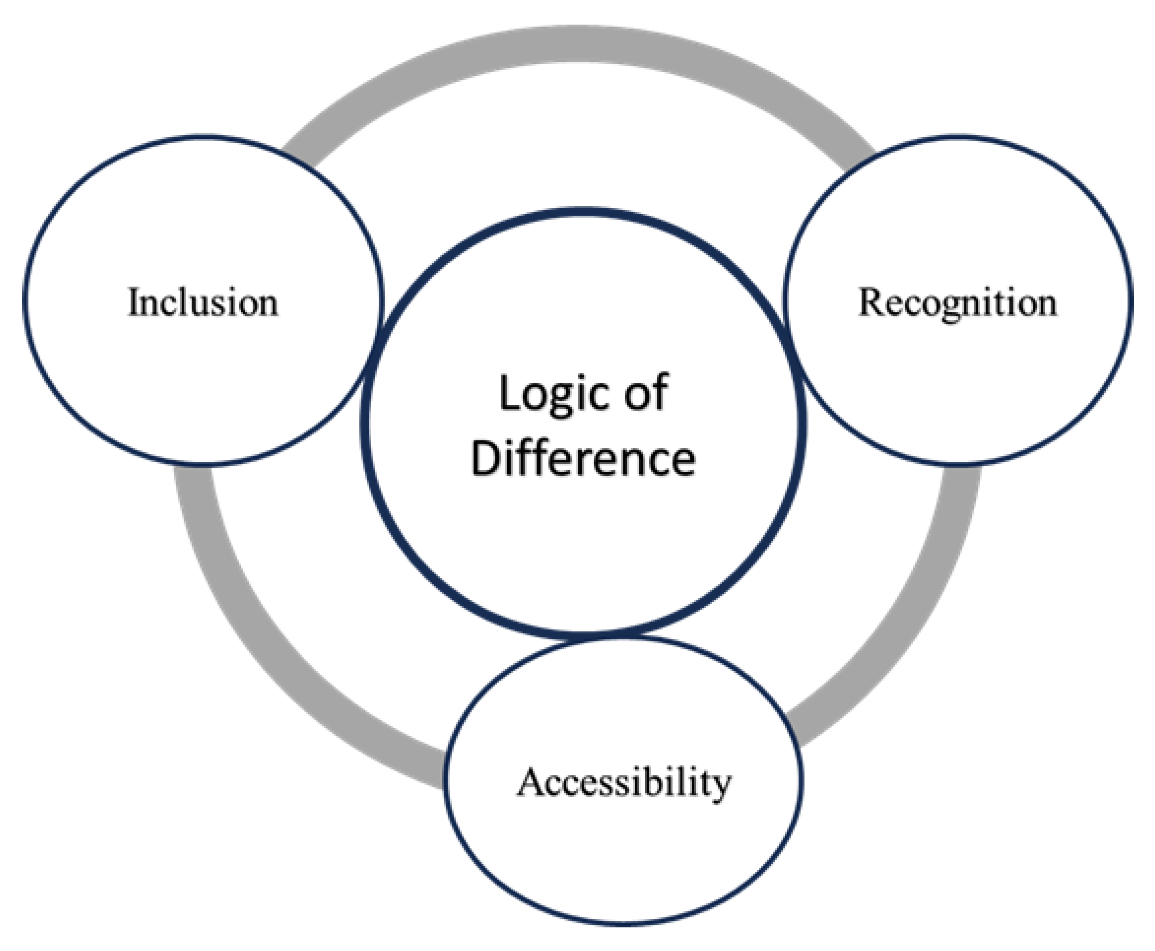
5. Conceptualization of the Role of Planning and Zoning Parameters in Promoting Social Justice
Drawing on the findings regarding the key dimensions through which the allocation of spatial planning or zoning parameters contributes to social justice, we propose a theoretical framework, Just Urbanism. This framework is built on the three identified concepts (see Figure 1), each addressing a key aspect of social justice: Inclusion, which captures how spatial planning or zoning parameters impact the social dynamics of belonging that shape individuals’ and groups’ positions within a hierarchically structured society; Accessibility, indicating the extent to which the allocation of spatial planning or zoning parameters affect the ease with which different social groups can reach, enter or gain into the available resources; Recognition, which demonstrates whether the needs, histories, cultural landmarks, and rights of diverse communities are acknowledged or neglected in the allocation of spatial planning or zoning parameters. These three dimensions are interdependent and deeply interconnected. Collectively, they provide insight into how the differential allocation of spatial planning or zoning parameters contributes to social justice in urban contexts.
At the core of the framework lies the logic of difference, a concept articulated by Laclau [65] and further applied in urban planning discourse by Jabareen and Eizenberg [66]. This perspective provides a theoretical lens for examining how the allocation of spatial planning or zoning parameters impacts social justice. However, it is important to clarify that the logic of difference employed here differs from the Difference Principle introduced by Rawls in A Theory of Justice [44], which emphasizes that social and economic inequalities are acceptable only if they benefit the least advantaged members of society.
By contrast, this paper adopts a broader interpretation of the logic of difference, extending beyond distribution to encompass the very constitution of social groups ( e.g., [65,66,67]. the logic of difference captures not only how the spatial planning or zoning parameters are allocated in the urban space but also how such allocations structure and signify social differentiation, by class, ethnicity, religion, race, origin, color, education, culture, and other social differentiations. In other words, the logic of difference illuminates how the state, through the allocation of spatial planning or zoning parameters, simultaneously distributes resources and inscribes categories of “we,” “others,” and “other others,” exposing the antagonisms and tensions inherent in socio-spatial configurations [66] (p.219). As Young[67] (p.157) notes, this logic assumes “an essentialist meaning of difference; it defines groups as having different natures.”
Accordingly, the conceptual framework of Just Urbanism captures the dynamics of difference in the distribution of inclusion, accessibility, and recognition among different social groups in cities. This theorization proceeds from the premise that spatial planning or zoning parameters are unevenly allocated within cities, producing spatial patterns of disparity in the quantity and quality of urban typologies, such as densities, housing types, and other land use profiles across neighborhoods. These urban typologies often correlate with social stratification along lines of socioeconomic status, race, ethnicity, and other social distinctions [21,68,69]. Such disparities, in turn, generate varying experience of urban justice among different social groups, particularly in terms of inclusion, recognition, and accessibility.
The dimension of inclusion captures the extent to which the allocation of spatial planning or zoning parameters through planning and development processes integrates diverse social groups across the urban contexts. However, the way these parameters are allocated often favors the inclusion of a certain population groups while excluding others. As Yiftachel [70] (p.397) observes, spatial policies unfold along “political, racial, class, gender, and sexual divisions,” thereby structuring unequal belonging to land, housing, and other urban resources. In this sense, the allocation of spatial planning or zoning parameters becomes a medium through which social hierarchies are spatially articulated and reproduced. Restrictive measures such as low-density zoning, mandatory parking requirements, building height limits, and the prioritization of single-family housing tend to privilege affluent and dominant populations, while excluding low-income or minority groups from well-serviced urban areas (see also [51,68,71,72]. These mechanisms effectively determine who is entitled to inhabit desirable urban spaces and who is displaced to the peripheries. This concern is also reflected in Wilson et al. [11] (p.212), who note that spatial policies often result in “the inequitable distribution of health-enriching resources to poor and minority communities,” thereby reinforcing urban inequities and social hierarchies. In this regard, spatial planning or zoning parameters should not be viewed merely as technical instruments, but as regulatory tools that embed social values, power relations, and normative judgments about who belongs where in the city. They therefore play a pivotal role in shaping the geography of inclusion and exclusion among different population groups within urban space.
The dimension of accessibility entails how the allocation of spatial planning or zoning parameters contributes to the ability of the diverse social groups to reach, gain entry to or tap into the resources they need or value. The way these parameters are allocated either facilitates or hinders certain population groups from accessing key amenities such as housing, education, healthcare, transportation, and green spaces. As Ribot and Peluso [73] (p.173) assert, policy regimes “enable and disable different actors to gain, maintain, or control resource access.” This is because the allocation of spatial planning or zoning parameters is inherently political, aligning with Soja [74] (p.275), who argue that planning practices constitute a “continuous and contentious process” shaped by politics, ideology, and power. In this context, the allocation of spatial planning or zoning parameters shapes which groups enjoy convenient access to high-quality infrastructure, services, and amenities, and which are left disconnected or underserved. Consequently, accessibility to available resources is unevenly produced among the different social groups. This creates “premium networked spaces” that favor affluent populations while systematically bypassing or excluding marginalized groups as cited by Oviedo [75].
The dimension of recognition captures the extent to which diverse identities, needs, and cultures are valued, respected, and acknowledged during allocation of spatial planning or zoning parameters. It reflects how planning practices through the allocation of these parameters symbolically and materially express societal hierarchies of worth, privileging some ways of living while devaluing others. Spatial planning or zoning parameters, such as density, housing types, parking requirements, building height, and others that guide the distribution of land uses, embed varying degrees of recognition among the different social groups. Through their spatial and regulatory expressions, these parameters reinforce symbolic hierarchies, signaling whose ways of living are legitimate, visible, and valued, and whose are marginalized, invisible, or deemed undesirable. As Fincher et al. [76] (p.45) contend, urban planning instruments have often been employed “to regulate and discipline the poor and marginalized minority groups,” while systematically favoring the needs, tastes, and lifestyles of dominant and affluent populations. These practices become visible in how the allocation of spatial planning or zoning parameters prioritize specific urban forms, such as private car-oriented infrastructure, high-end housing typologies, and exclusionary public spaces, that cater primarily to middle- and upper-income groups. Conversely, the needs of low-income and minority groups, such as affordable housing, accessible public transportation, community spaces, and culturally relevant infrastructure, are often restricted, stigmatized, or entirely omitted from official plans. According to Fraser [77], as cited in Eizenberg et al. [59] (p.206), this exclusion not only shapes the spatial form of cities but also reinforces social subordination, whereby marginalized populations are “prevented from participating as peers in social life”. Moreover, low-income and minority populations frequently occupy what Yiftachel [78] (p. 250) describes as a state of “gray space”, a liminal zone “between the lightness of legality, approval, and safety, and the darkness of eviction, destruction, and death.” Hence, the pursuit of social justice in the allocation of spatial planning or zoning parameters requires not only the redistribution of urban resources but also a full recognition of diverse social and cultural identities as integral to the urban fabric. As Fraser [60] argues, achieving justice entails addressing both redistribution and recognition, ensuring that all the identities, needs, and cultures of diverse social groups are equally acknowledged in shaping urban life.
As underlined above, each concept within the conceptual framework reflects a distinct social dimension that contributes to social justice in cities. Central to this framework is the logic of difference, which captures disparities in the distribution of inclusion, accessibility, and recognition among social groups resulting from the differential allocation of spatial planning or zoning parameters. In this regard, the study is distinctive in its direct focus on these parameters. It offers a novel framework for understanding how their allocation contributes to social justice. This approach provides a valuable theoretical contribution by demonstrating the impact of specific spatial planning or zoning parameters, such as density, housing types, minimum lot sizes, parking requirements, building heights and land use allocation such as green space, on the construction of urban justice across different population groups.
6. Conclusions
In this paper, we argue that spatial planning, land-use, and zoning parameters function as mechanisms for delivering resources through planning and development processes; they are not merely technical spatial measures but serve as a carrier of urban justice. The allocation of these parameters is therefore deeply political and crucial for understanding how the state distributes resources in the city. Consequently, ensuring fairness in the allocation of spatial planning or zoning parameters is fundamental to promoting social justice in urban contexts.
This paper proposes a new conceptual framework of Just Urbanism that seeks to understand how the allocation of spatial planning or zoning parameters contributes to social justice in cities. The framework consists of three interrelated concepts, each representing a distinct aspect of social justice: Inclusion, capturing the extent to which different social groups are integrated into the newly planned spaces; Accessibility, referring the degree to which urban resources and services are available, reachable, and usable by all population groups; and Recognition, reflecting the degree of acknowledgment and valuing of diverse identities, needs, and cultural expressions within the urban context. These dimensions operate interdependently and are inextricably intertwined in shaping the social justice outcomes of allocation of spatial planning or zoning parameters.
At the core of the framework lies the logic of difference, which serves as an ontological foundation for understanding the impacts of the allocation of these parameters through the lens of social justice. It captures how the state, through the allocation of spatial planning or zoning parameters, inscribes categories of difference and disparity among the population groups or across urban contexts, particularly in the distribution of inclusion, accessibility, and recognition.
While the allocation of spatial planning or zoning parameters contributes significantly to social justice in cities. their investigation remains fragmented, as most of the literature focuses specifically on individual spatial planning or zoning parameters rather than all of them together. The proposed conceptual framework offers a comprehensive understanding of how the distribution of each parameter, and all of them collectively contributes to social justice in urban contexts. It also contributes to understanding the state’s politics in the realm of planning and spatial policies, particularly on how spatial planning or zoning parameters are allocated among different socio-economic and racial/ethnic groups, and how these allocations contribute to differences and disparities across urban areas and populations.
Practically, this framework provides valuable insights for policymakers and planners by illustrating how the allocation of spatial planning or zoning parameters directly impacts urban justice for diverse social groups. It guides them to recognize that ensuring fairness in the allocation of these parameters is vital to promoting social justice in cities. Furthermore, the framework and its underlying concepts can assist planners, policymakers and scholars in evaluating planning and zoning practices and analyzing their contribution to social justice.
Future studies are encouraged to apply the proposed conceptual framework of Just Urbanism in empirical research. This will enable a holistic analysis of how the allocation of various spatial planning or zoning parameters contributes to social justice in the urban context.
Data Availability Statement
Not applicable.
Acknowledgments
Not applicable.
Conflicts of Interest
The authors declare no conflicts of interest.
References
- Espitia, C. Urban Planning for Social Justice in Latin America; Routledge: London, 2023; ISBN 978-1-003-38081-8. [Google Scholar]
- Fainstein The Just City; Cornell University Press: Ithaca, 2010; ISBN 978-0-8014-4655-9.
- Fainstein, S. Resilience and Justice: Planning for New York City. The Resilience Machine; Routledge. 2018. [Google Scholar]
- Harvey, D. Social Justice and the City; The University of Georgia Press: Athens & London, 1973. [Google Scholar]
- Marcuse, P.; Connolly, J.; Novy, J.; Olivo, I.; Potter, C.; Steil, J. Searching for the Just City: Debates in Urban Theory and Practice; 2009; ISBN 978-0-203-87883-5.
- Mitchell, D. Social Justice and the City and the Problem of Status Quo Theory. Scott. Geogr. J. 2023. [Google Scholar] [CrossRef]
- Moroni, S. The Just City. Three Background Issues: Institutional Justice and Spatial Justice, Social Justice and Distributive Justice, Concept of Justice and Conceptions of Justice. Plan. Theory 2020, 19, 251–267. [Google Scholar] [CrossRef]
- Uitermark, J.; Nicholls, W. Planning for Social Justice: Strategies, Dilemmas, Tradeoffs. Plan. THEORY 2017, 16, 32–50. [Google Scholar] [CrossRef]
- Alterman, R. Planning Laws, Development Controls, and Social Equity: Lessons for Developing Countries. Law Justice Dev. Ser. 2013, 329–350. [Google Scholar] [CrossRef]
- Ng, M.K. Planning Standards and Spatial (in)Justice. Plan. Theory Pract. 2022, 23, 167–172. [Google Scholar] [CrossRef]
- Wilson, S.; Hutson, M.; Mujahid, M. How Planning and Zoning Contribute to Inequitable Development, Neighborhood Health, and Environmental Injustice. Environ. Justice 2008, 1, 211–216. [Google Scholar] [CrossRef]
- Yunda, J.G.; Jiao, J. Zoning Changes and Social Diversity in New York City, 1990–2015. J. Urban. Int. Res. Placemaking Urban Sustain. 2019, 12, 230–243. [Google Scholar] [CrossRef]
- Wilson, J. Q The Politics of Regulation; (Ed.).; Basic Books: New York, 1980. [Google Scholar]
- Davidoff, P.; Davidoff, L. Opening the Suburbs: Towards Inclusionary Land Use Controls. Syracuse Law Rev. 1971, 22, 509–536. [Google Scholar]
- Downs, A. Opening up the Suburbs: An Urban Strategy for America; 2. pr.; Yale Univ. Pr: New Haven, 1975; ISBN 978-0-300-01455-6. [Google Scholar]
- W. A. Fischel The Homevoter Hypothesis; Harvard University Press: Cambridge MA, 2001. [Google Scholar]
- Levine, Jonathan Zoned Out: Regulation, Markets, and Choices in Transportation and Metropolitan Land-Use; Resources for the Future: Washington, DC, 2005.
- Chakraborty, A.; Knaap, G.-J.; Nguyen, D. ; Jung Ho Shin The Effects of High-Density Zoning on Multifamily Housing Construction in the Suburbs of Six US Metropolitan Areas. Urban Stud. 2010, 47, 437–451. [Google Scholar] [CrossRef]
- Rothwell, J.; Massey, D.S. The Effect of Density Zoning on Racial Segregation in U.S. Urban Areas. Urban Aff. Rev. 2009, 44, 779–806. [Google Scholar] [CrossRef]
- Shertzer, A.; Twinam, T.; Walsh, R.P. Race, Ethnicity, and Discriminatory Zoning. Am. Econ. J. Appl. Econ. 2016, 8, 217–246. [Google Scholar] [CrossRef]
- Furth, S.; Webster, M. Single-Family Zoning and Race: Evidence From the Twin Cities. Hous. Policy Debate 2023, 1–23. [Google Scholar] [CrossRef]
- Manville, M.; Monkkonen, P.; Lens, M. It’s Time to End Single-Family Zoning. J. Am. Plann. Assoc. 2020, 86, 106–112. [Google Scholar] [CrossRef]
- Gabbe, C.J.; Pierce, G. Hidden Costs and Deadweight Losses: Bundled Parking and Residential Rents in the Metropolitan United States. Hous. Policy Debate 2016, 27, 217–229. [Google Scholar] [CrossRef]
- Guo, Z. Residential Street Parking and Car Ownership. J. Am. Plann. Assoc. 2013, 79, 32–48. [Google Scholar] [CrossRef]
- Manville, M. Parking Requirements and Housing Development. J. Am. Plann. Assoc. 2013, 79, 49–66. [Google Scholar] [CrossRef]
- McDonnell, S.; Madar, J.; Been, V. Minimum Parking Requirements and Housing Affordability in New York City. Hous. Policy Debate 2010, 21, 45–68. [Google Scholar] [CrossRef]
- Ferguson, M.; Roberts, H.E.; McEachan, R.R.C.; Dallimer, M. Contrasting Distributions of Urban Green Infrastructure across Social and Ethno-Racial Groups. Landsc. Urban Plan. 2018, 175, 136–148. [Google Scholar] [CrossRef]
- Li, H.; Liu, Y. Neighborhood Socioeconomic Disadvantage and Urban Public Green Spaces Availability: A Localized Modeling Approach to Inform Land Use Policy. Land Use Policy 2016, 57, 470–478. [Google Scholar] [CrossRef]
- Liu, D.; Kwan, M.-P.; Kan, Z. Analysis of Urban Green Space Accessibility and Distribution Inequity in the City of Chicago. Urban For. Urban Green. 2021, 59, 127029. [Google Scholar] [CrossRef]
- Venter, Z.S.; Shackleton, C.M.; Van Staden, F.; Selomane, O.; Masterson, V.A. Green Apartheid: Urban Green Infrastructure Remains Unequally Distributed across Income and Race Geographies in South Africa. Landsc. Urban Plan. 2020, 203, 103889. [Google Scholar] [CrossRef]
- Wu, L.; G. Rowe, P. Green Space Progress or Paradox: Identifying Green Space Associated Gentrification in Beijing. Landsc. Urban Plan. 2022, 219, 104321. [Google Scholar] [CrossRef]
- Hosseini, A.; Farhadi, E.; Hussaini, F.; Pourahmad, A.; Seraj Akbari, N. Analysis of Spatial (in)Equality of Urban Facilities in Tehran: An Integration of Spatial Accessibility. Environ. Dev. Sustain. 2022, 24, 6527–6555. [Google Scholar] [CrossRef]
- Mayaud, J.R.; Tran, M.; Nuttall, R. An Urban Data Framework for Assessing Equity in Cities: Comparing Accessibility to Healthcare Facilities in Cascadia. Comput. Environ. Urban Syst. 2019, 78, 101401. [Google Scholar] [CrossRef]
- Landry, S.M.; Chakraborty, J. Street Trees and Equity: Evaluating the Spatial Distribution of an Urban Amenity. Environ. Plan. Econ. Space 2009, 41, 2651–2670. [Google Scholar] [CrossRef]
- Thornton, C.M.; Conway, T.L.; Cain, K.L.; Gavand, K.A.; Saelens, B.E.; Frank, L.D.; Geremia, C.M.; Glanz, K.; King, A.C.; Sallis, J.F. Disparities in Pedestrian Streetscape Environments by Income and Race/Ethnicity. SSM - Popul. Health 2016, 2, 206. [Google Scholar] [CrossRef]
- Meltzer, R.; Schuetz, J. Bodegas or Bagel Shops? Neighborhood Differences in Retail and Household Services. Econ. Dev. Q. 2012, 26, 73–94. [Google Scholar] [CrossRef]
- Powell, L.M.; Slater, S.; Mirtcheva, D.; Bao, Y.; Chaloupka, F.J. Food Store Availability and Neighborhood Characteristics in the United States. Prev. Med. 2007, 44, 189–195. [Google Scholar] [CrossRef]
- Guzman, L.A.; Oviedo, D.; Arellana, J.; Cantillo-García, V. Buying a Car and the Street: Transport Justice and Urban Space Distribution. Transp. Res. Part Transp. Environ. 2021, 95, 102860. [Google Scholar] [CrossRef]
- Kelly, C.M.; Schootman, M.; Baker, E.A.; Barnidge, E.K.; Lemes, A. The Association of Sidewalk Walkability and Physical Disorder with Area-Level Race and Poverty. J. Epidemiol. Community Health 2007, 61, 978–983. [Google Scholar] [CrossRef] [PubMed]
- Cornell, D. , Rosenfeld, M.; Carlson, D.G. (Eds. ) Deconstruction and the Possibility of Justice; Psychology Press. 1992. [Google Scholar]
- Derrida, J. Of Grammatology; Translated by Gayatri Chakravorty Spirat, Ed.; The Johns Hopkins University Press: Baltimore and London, 1997.
- Gormley, S. Deliberative Theory and Deconstruction. In Deliberative Theory and Deconstruction; Edinburgh University Press. 2020. [Google Scholar]
- Rasche, A. Organizing Derrida Organizing: Deconstruction and Organization Theory. In In Philosophy and organization theory; Emerald Group Publishing Limited, 2011; pp. 254–255.
- Rawls, J. A Theory of Justice (Revised Edition; Harvard University Press: Cambridge, 1971. [Google Scholar]
- Nozick Anarchy, State, and Utopia; 1974; Vol. 5038;
- Pogge, T Realizing Rawls.; Cornell University Press, 1989.
- Sen, A The Idea of Justice; Penguin Books Ltd.: New Delhi, 2009.
- Valentini, L. A Paradigm Shift in Theorizing about Justice? A Critique of Sen. Econ. Philos. 2011, 27, 297–315. [Google Scholar] [CrossRef]
- Anttiroiko, A.-V.; De Jong, M. Conceptualizing Exclusion and Inclusion. In The Inclusive City; Springer International Publishing: Cham, 2020; ISBN 978-3-030-61364-8. [Google Scholar]
- Ye, J. Re-Orienting Geographies of Urban Diversity and Coexistence: Analyzing Inclusion and Difference in Public Space. Prog. Hum. Geogr. 2019, 43, 478–495. [Google Scholar] [CrossRef]
- Ihlanfeldt, K.R.; Moore, L.; Ihlanfeldt, K.R. Exclusionary Land-Use Regulations within Suburban Communities: A Review of the Evidence and Policy Prescriptions. Urban Stud. 2004, 41, 261–283. [Google Scholar] [CrossRef]
- Song, J. The Effects of Residential Zoning in U.S. Housing Markets. SSRN Electron. J. 2021. [Google Scholar] [CrossRef]
- Glaeser, E.L.; Ward, B.A. The Causes and Consequences of Land Use Regulation: Evidence from Greater Boston. J. Urban Econ. 2009, 65, 265–278. [Google Scholar] [CrossRef]
- Lusugga Kironde, J.M. The Regulatory Framework, Unplanned Development and Urban Poverty: Findings from Dar Es Salaam, Tanzania. Land Use Policy 2006, 23, 460–472. [Google Scholar] [CrossRef]
- Alam, B.M.; Thompson, G.L.; Brown, J.R. Estimating Transit Accessibility with an Alternative Method: Evidence from Broward County, Florida. Transp. Res. Rec. J. Transp. Res. Board 2010, 2144, 62–71. [Google Scholar] [CrossRef]
- Páez, A.; Scott, D.M.; Morency, C. Measuring Accessibility: Positive and Normative Implementations of Various Accessibility Indicators. J. Transp. Geogr. 2012, 25, 141–153. [Google Scholar] [CrossRef]
- Dai, D. Racial/Ethnic and Socioeconomic Disparities in Urban Green Space Accessibility: Where to Intervene? Landsc. Urban Plan. 2011, 102, 234–244. [Google Scholar] [CrossRef]
- Cho, H. The Politics of Recognition and Planning Practices in Diverse Neighbourhoods: Korean Chinese in Garibong-Dong, Seoul. Urban Stud. 2021, 58, 2863–2879. [Google Scholar] [CrossRef]
- Eizenberg, E.; Jabareen, Y.; Arviv, T.; Arussy, D. Urban Space of Recognition: Design for Ethno-Cultural Diversity in the German Colony, Haifa. J. Urban Des. 2022, 27, 205–224. [Google Scholar] [CrossRef]
- Fraser, N. Recognition or Redistribution? A Critical Reading of Iris Young’s Justice and the Politics of Difference *. J. Polit. Philos. 1995, 3, 166–180. [Google Scholar] [CrossRef]
- Hanson, H.I.; Alkan Olsson, J. The Link Between Urban Green Space Planning Tools and Distributive, Procedural and Recognition Justice. In Human-Nature Interactions; Misiune, I., Depellegrin, D., Egarter Vigl, L., Eds.; Springer International Publishing: Cham, 2022; ISBN 978-3-031-01979-1. [Google Scholar]
- A. , R.; Flohr Access to Parks for Youth as an Environmental Justice Issue: Access Inequalities and Possible Solutions. buildings 2014, 4, 69–94. [Google Scholar] [CrossRef]
- Nicolaides, B.M.; Zarsadiaz, J. Design Assimilation in Suburbia: Asian Americans, Built Landscapes, and Suburban Advantage in Los Angeles’s San Gabriel Valley since 1970. J. Urban Hist. 2017, 43, 332–371. [Google Scholar] [CrossRef]
- Thornton, C.M.; Conway, T.L.; Cain, K.L.; Gavand, K.A.; Saelens, B.E.; Frank, L.D.; Geremia, C.M.; Glanz, K.; King, A.C.; Sallis, J.F. Disparities in Pedestrian Streetscape Environments by Income and Race/Ethnicity. SSM - Popul. Health 2016, 2, 206–216. [Google Scholar] [CrossRef]
- Laclau, E. On Populist Reason.; Verso. 2005. [Google Scholar]
- Jabareen, Y.; Eizenberg, E. Theorizing Urban Social Spaces and Their Interrelations: New Perspectives on Urban Sociology, Politics, and Planning. Plan. Theory 2021, 20, 211–230. [Google Scholar] [CrossRef]
- Young, I.M. Justice and the Politics of Difference.; Princeton University Press.: New Jersey:, 1990. [Google Scholar]
- Lens, M.C.; Monkkonen, P. Do Strict Land Use Regulations Make Metropolitan Areas More Segregated by Income? J. Am. Plan. Assoc. Am. Plan. Assoc. 2016, 82, 6. [Google Scholar] [CrossRef]
- Lynge, H.; Visagie, J.; Scheba, A.; Turok, I.; Everatt, D.; Abrahams, C. Developing Neighbourhood Typologies and Understanding Urban Inequality: A Data-Driven Approach. Reg. Stud. Reg. Sci. 2022, 9, 618–640. [Google Scholar] [CrossRef]
- Yiftachel, O. Planning and Social Control: Exploring the Dark Side. J. Plan. Lit. 1998, 12, 395–406. [Google Scholar] [CrossRef]
- Clifford, B.; Ferm, J. Planning, Regulation and Space Standards in England: From “homes for Heroes” to “Slums of the Future.” Town Plan. Rev. 2021. [Google Scholar] [CrossRef]
- Pendall, R. Local Land Use Regulation and the Chain of Exclusion. J. Am. Plann. Assoc. 2000, 66, 125–142. [Google Scholar] [CrossRef]
- Ribot, J.C.; Peluso, N.L. A Theory of Access*. Rural Sociol. 2003, 68, 153–181. [Google Scholar] [CrossRef]
- Soja, E. Writing the City Spatially 1. City 2003, 7, 269–280. [Google Scholar] [CrossRef]
- Oviedo, D. Making the Links between Accessibility, Social and Spatial Inequality, and Social Exclusion: A Framework for Cities in Latin America. Adv. Transp. Policy Plan. 2021, 8, 135–172. [Google Scholar] [CrossRef]
- Fincher, R.; Iveson, K.; Leitner, H.; Preston, V. Planning in the Multicultural City: Celebrating Diversity or Reinforcing Difference? Prog. Plan. 2014, 92, 1–55. [Google Scholar] [CrossRef]
- Fraser, N. Rethinking Recognition; 2000; Vol. New left review.
- Yiftachel, O. Critical Theory and ‘Gray Space’: Mobilization of the Colonized. City 2009, 13, 246–263. [Google Scholar] [CrossRef]
Figure 1.
The conceptual framework of Just urbanism.
Disclaimer/Publisher’s Note: The statements, opinions and data contained in all publications are solely those of the individual author(s) and contributor(s) and not of MDPI and/or the editor(s). MDPI and/or the editor(s) disclaim responsibility for any injury to people or property resulting from any ideas, methods, instructions or products referred to in the content. |
© 2025 by the authors. Licensee MDPI, Basel, Switzerland. This article is an open access article distributed under the terms and conditions of the Creative Commons Attribution (CC BY) license (http://creativecommons.org/licenses/by/4.0/).
Copyright: This open access article is published under a Creative Commons CC BY 4.0 license, which permit the free download, distribution, and reuse, provided that the author and preprint are cited in any reuse.


