
Submitted:
28 October 2025
Posted:
29 October 2025
You are already at the latest version
Abstract
Pingshun County in Changzhi City, Shanxi Province, has preserved a rich array of intangible cultural heritage due to its long history, unique geographical environment, the influence of religious culture, and local conservation measures. This paper takes the basic information of national, provincial, and county-level cultural heritage sites in Pingshun County, Changzhi City, Shanxi Province, as the research object. It employs the Average Nearest Neighbor, Kernel Density Analysis, and Standard Deviational Ellipse tools in ArcGIS 10 software to analyze the spatiotemporal distribution characteristics of different types and periods of cultural heritage sites, providing a strong data support for their protection and utilization. The results show that the distribution of different types of cultural heritage sites in Pingshun County is uneven. Ancient architecture sites are mainly concentrated in Shicheng Town and Beishe Township, while modern important historical sites and representative buildings are primarily located in Shicheng Town and Yanggao Township. The distribution of cultural heritage sites across different periods in Pingshun County is also uneven, with a general pattern of higher numbers and earlier periods along the Zhuozhang River valley in the eastern and northern regions.
Keywords:
cultural heritage sites
; spatiotemporal distribution characteristics
; influencing factors
; ArcGIS
0. Introduction
Cultural heritage sites are the precious material cultural heritage of our country, embodying the wisdom and crystallization of the Chinese nation's millennia-long historical and cultural traditions. The study and protection of these sites are not only essential for safeguarding the foundations of historical and cultural traditions but also crucial for the transmission of outstanding national spirit and cultural genes [1]. Shanxi Province, located in the middle reaches of the Yellow River, is one of the cradles of Chinese civilization and boasts 531 national key cultural heritage sites, the highest number in the country [2]. PingShun County in ChangZhi City, Shanxi Province, has preserved a rich array of intangible cultural heritage due to its long history, unique geographical environment, religious cultural influence, and local conservation measures. Within its 1,550 square kilometers, there are over 500 cultural relics, including 15 national key cultural heritage sites, making it the only county in the country that has preserved wooden architectural structures from the Tang to the Qing dynasties[3]. The cultural heritage conservation cause, as an important component of China's national institutional system, has been highly valued since the founding of New China. In-depth exploration of the spatiotemporal distribution patterns and driving mechanisms of these sites is not only of significant theoretical value but also has profound practical significance for advancing national political construction, economic development, and cultural prosperity [4]. This study takes the cultural heritage sites in PingShun County, ChangZhi City, Shanxi Province, as the research object and uses ArcGIS 10.8 software to analyze their spatiotemporal distribution characteristics and influencing factors.
Existing research on the cultural relics in PingShun County, ChangZhi City, Shanxi Province, has mainly focused on traditional villages and specific cultural heritage sites. Hu Pan et al. constructed a contiguous protection system and utilization strategy for traditional villages in PingShun County by analyzing their historical culture, current utilization status, and spatiotemporal distribution[3]. Huang Xingqi explored the artistic characteristics and carving techniques of the stone carvings in JinDeng Temple in PingShun County, revealing their inherent historical information and cultural value [5]. Ma Hui studied the content, materials, and techniques of the murals in NanShe YuHuang Temple in PingShun County, providing a basis for their subsequent protection and utilization [6]. However, these studies have not systematically analyzed the spatiotemporal distribution patterns and influencing factors of all cultural heritage sites within the county.
The history of PingShun County can be traced back to ancient times. The cultural heritage of this region is characterized by a wide range of ages, rich typological diversity, and extensive geographical distribution. However, the current comprehensive protection and spatial coordination are still insufficient, highlighting the urgent need for structured research[7]. This study utilizes a dataset composed of two core elements: cultural heritage data and spatial vector data. With the aid of ArcGIS 10.8 software, a multi-angle analysis of the spatiotemporal distribution characteristics and main influencing factors of cultural heritage sites at various levels in PingShun County is conducted.
1. Data Sources and Research Methods
1.1. Data Sources
The present study employs cultural heritage sites at all administrative levels in Pingshun County, Changzhi City, Shanxi Province, as the primary data source. Particular attention is paid to those heritage units officially designated by the Chinese government at and after the proclamation of the First Batch of Major Historical and Cultural Sites Protected at the National Level on 4 March 1961 by the State Council of the People’s Republic of China. The resultant heritage data set records, for each site, its official name, typological classification, and geographical coordinates (WGS-84). Ancillary spatial-vector layers include: (i) administrative boundaries (county and township level); (ii) geo-referenced heritage point features; (iii) road and river networks; (iv) hydrographic features; and (v) a 30 m-resolution digital elevation model (DEM).
1.2. Research Methods
1.2.1. Average Nearest Neighbour Index (ANN)
In ArcGIS Pro 3.x (Environmental Systems Research Institute, Redlands, CA, USA), the Average Nearest Neighbour (ANN) tool is invoked to quantify the spatial distribution pattern of point features. The index is computed as the ratio of the observed mean nearest-neighbour distance to the expected mean distance under complete spatial randomness (CSR). Formally,
where
ANN = observed mean nearest-neighbour distance;
n = number of points;
A = area of the study region.
1.2.2. Geographic Concentration Index (G)
where
G = geographic concentration index;
n = number of county-level administrative units in Changzhi City;
= count of traditional villages in the i-th unit;
T = total number of traditional villages in the study area.
The theoretical value ( G under a perfectly even distribution) is computed as 100/√n.
If G > → concentration is higher than random-equal;
If G < → distribution is more dispersed than the even be
1.2.3. Imbalance Index (S)
where
= imbalance index, range [0,1];
= cumulative percentage of traditional villages in the i-th county when counties are ranked in descending order;
n = total number of counties.
Interpretation:
S = 0 → perfectly equal distribution among counties;
S = 1 → all villages concentrated in a single county;
larger → higher spatial inequality.
1.2.4. Kernel Density Estimation (KDE)
where
= kernel density estimate at location x;
K = symmetric kernel function (Gaussian kernel by default);
= geographic coordinate of the i-th heritage point;
h = bandwidth (smoothing parameter).
A higher indicates a denser clustering of events and, consequently, an elevated probability of site occurrence within the s
2. Spatiotemporal Distribution Characteristics
Through a comprehensive analysis of immovable cultural relics in Pingshun County, it was found that there are a total of 520 immovable cultural relics in the county, including 15 national-level immovable cultural relics, 10 provincial-level immovable cultural relics, 19 municipal-level immovable cultural relics, 51 county-level immovable cultural relics, and 425 immovable cultural relics that have not yet been classified[8].
These 520 cultural heritage sites are distributed across the five towns and seven townships of Pingshun County. By overlaying the geographical locations of each cultural heritage site on the administrative map of Pingshun County in ArcGIS 10.8 software, a spatial distribution map of cultural heritage sites in Pingshun County (Figure 1) was created. Additionally, a summary of the number and density of cultural relics in each township of Pingshun County was produced using tabular methods (Table 1). As can be seen from Figure 1 and Table 1, the cultural heritage sites in Pingshun County are generally unevenly distributed across the administrative regions. Specifically, Shicheng Town has the highest number of cultural relics, with 96 sites; followed by Beishe Township, with 88 sites; Yanggao Township and Beidanche Township, with 62 and 59 sites respectively; Longxi Town has the fewest, with only 13 sites. The average number of sites per district is approximately 43. In terms of density, Beishe Township has the highest density, at about 1.29 sites per square kilometer; followed by Miaozhuang Town, at about 0.89 sites per square kilometer; Shicheng Town, at about 0.61 sites per square kilometer; and the lowest density is in Dongtousi Township, at about 0.09 sites per square kilometer.
2.1. Spatial Agglomeration Characteristics of Different Types of Cultural Heritage Sites
Pingshun County has five main types of cultural heritage sites: ancient architecture, ancient tombs, ancient sites, grotto temples and rock carvings, and modern important historical sites and representative buildings[9]. By analyzing and summarizing the 520 data points of national, provincial, municipal, and county-level cultural heritage sites in Pingshun County according to these five main types, a bar chart of the classification statistics of cultural heritage sites in Pingshun County was created (Figure 2). As can be seen from Figure 2, overall, the number of ancient architecture sites is the highest, with a total of 340 sites, reflecting the rich historical architectural heritage of the area. The number of modern important historical sites and representative buildings is the second highest, with 89 sites. These two types alone account for 82.5% of all cultural heritage sites in Pingshun County. In contrast, the number of ancient tombs is the lowest, with only 9 sites, accounting for 1.73% of the total. Types such as grotto temples and rock carvings, and ancient tombs, are only found in a few areas, indicating that the distribution of these types of remains is regionally specific[10]. In terms of administrative divisions, the number of cultural heritage sites varies across different regions. The number of ancient architecture sites is generally higher than other types. For example, Shicheng Town and Beishe Township have a significantly higher number of ancient architecture sites compared to other types. Modern important historical sites and representative buildings, grotto temples, and rock carvings are unevenly distributed across different regions[11]. For example, modern important historical sites and representative buildings are mainly found in Shicheng Town and Yanggao Township, while ancient tombs are only found in four townships, including Shicheng Town.
To investigate the spatial distribution characteristics of different types of cultural heritage sites, the Average Nearest Neighbor tool in ArcGIS software was used to calculate the nearest neighbor index of cultural heritage sites in Pingshun County (Table 2), and the Kernel Density tool was used to create the kernel density map of different types of cultural heritage sites in Pingshun County (Figure 3). As can be seen from Table 2, overall, the nearest neighbor indices of ancient architecture, modern important historical sites and representative buildings, and ancient sites are all less than 1, indicating that these types of cultural heritage sites exhibit clustered distributions, with the degree of clustering decreasing in that order. The nearest neighbor indices of ancient tombs and grotto temples and rock carvings are both greater than 1, indicating that these types of cultural heritage sites exhibit dispersed distributions.
Specifically, as shown in Figure 3a, the core distribution area of ancient architecture is concentrated in the intersection of Yanggao Township and Beidanche Township along the banks of the Zhuozhang River. This area is characterized by a cluster of Song and Jin Dynasty wooden structures, including the nationally protected cultural heritage sites of Dayun Temple (Five Dynasties), Tiantai Temple (Tang Dynasty), and Chunhua Temple (Jin Dynasty). The dense distribution of these sites is attributed to the economic and cultural prosperity brought about by the water transportation along the Zhuozhang River in history.
The secondary distribution areas exhibit a dual-core pattern: the northern core is centered in Shicheng Town, preserving the Minghui Master Pagoda (Five Dynasties) and the fortifications along the line; the southern core is located in Miaozhuang Town, which is mainly characterized by a cluster of folk temples from the Ming and Qing Dynasties, such as the Beiganquan Holy Mother Temple. It is worth noting that the ancient architecture in Pingshun County shows a significant dependence on the river basin, with 83% of the national and provincial protected units distributed within 10 kilometers of the Zhuozhang River and its tributaries.
As shown in Figure 3b, modern important historical sites exhibit a single-core distribution feature, with the core area located in Xigou Township. This area is centered around the site of the nation's earliest agricultural cooperative (Xigou Village), linking the former residence of Li Shunda and the Shen Jilan Memorial Hall, forming a unique "contemporary spiritual landmark cluster." Its spatial layout breaks the traditional pattern of cultural relic distribution and is deeply embedded in the modern village texture.
As shown in Figure 3c, the distribution of ancient tombs is characterized by dispersion, mainly existing in two major areas: the Miaozhuang Town Han Dynasty tomb cluster, as the earliest tomb remains in the county, reflects the distribution of Han Dynasty settlements; the Beishe Township Qing Dynasty tomb cluster, which is concentrated in the Qing Dynasty family cemetery, is closely related to the rise and fall of commercial families in the Ming and Qing Dynasties. Ancient tombs are clearly avoided in the core residential areas and are mostly located on the loess plateau above 900 meters in altitude, taking into account both waterproofing, anti-corrosion, and feng shui considerations.
As Figure 3d illustrates, ancient-ruin distribution exhibits a three-tiered pattern. The core tier clusters in the mid-Zhuozhang valley between Beidanche and Yanggao townships, forming a dense prehistoric-to-Shang/Zhou zone. The Anle Neolithic cluster (Yangshao and Longshan layers) and the Che Dang Shang/Zhou settlement face each other across the river, constituting an early-civilisation "dual core" confined to the 650–750 m riverine second terrace—optimal for water access and flood safety. A secondary linear belt runs along the northern Hongni valley iron-smelting sites, centring on the Ming-period Hongtiguan furnaces (four smelters, two mines), corroborating the Lüzhou Chronicle claim that "Pingshun iron tops Shangdang." Scattered outliers occur in Xingcheng’s prehistoric mountain-fort group along the 1,300 m Taihang ridge, including the Western Luo Spring stone wall and three beacon towers—a defensive system sharing the "commanding-heights" principle with grave sites but at higher elevation (1,300 m vs. 900 m), underscoring strategic defence.
Figure 3e shows that grotto temples and rock carvings concentrate absolutely at Jindeng Temple, Yuxiaguan Town. This Ming-era complex, the largest in south-eastern Shanxi, sits on the 1,700 m summit of Mount Linlü, embodying the tradition "far from worldly clamour, near sacred terrain." A linear corridor follows the Zhuozhang gorge, where cliff faces preserve abundant Song-Ming cliff inscriptions (e.g., Wangqu Tiantai Temple cliff texts), forming a "stone-inscription gallery" that coincides with the ancient Taihang thoroughfare.
In summary, three rules emerge:
1. Physical geography dominance—80 % of high-grade relics cluster in the Zhuozhang valley, confirming "settle along the river";
2. Chronological layering—Tang remains hug low valley floors (Tiantai Temple), whereas Ming-Qing structures migrate to higher terraces (Beishe Sanjiao Temple);
3. Defensive outliers—pass sites such as Hongtiguan inscriptions strictly track the Eight Taihang Passes, while modern heritage innovates by embedding "living heritage" within contemporary communities.
2.2. Spatial Agglomeration Characteristics of Heritage Sites Across Historical Periods
The time span of the sites was divided into six chronological stages: pre-Qin, Qin-Han–Wei-Jin–Northern & Southern Dynasties, Sui-Tang–Five Dynasties, Song-Yuan, Ming-Qing, and modern times; four undated sites were excluded[12]. Using 516 records of national, municipal and county-level sites, a chronological bar chart was produced (Figure 4).
Overall, the Ming-Qing period dominates with 369 sites, followed by the modern era with 83 sites; together they account for ca. 87.6 % of the total. The Qin-Han–Wei-Jin–Northern & Southern Dynasties and the Sui-Tang–Five Dynasties periods are the scarcest, each contributing only 7 sites (1.6 %).
At township level, Beishe has the highest number of pre-Qin and Qin-Han–Wei-Jin period remains, indicating the longest continuity of settlement and cultural deposition. Beidanche, Yanggao and Shicheng—townships traversed by the Zhuozhang River—each contain more than 50 sites, confirming the valley as a hotspot of heritage concentration. Qingyang and Beishe, meanwhile, host sites from every chronological stage, reflecting comparatively persistent and stable cultural development across all historical periods.
To further illustrate the spatial distribution characteristics of cultural heritage sites across different historical periods, the Average Nearest Neighbor tool in ArcGIS software was used to create a line chart of the average nearest neighbor index for cultural heritage sites in Pingshun County over different periods (Figure 5), and the Kernel Density tool was used to generate a kernel density map of cultural heritage sites in Pingshun County (Figure 6). As can be seen from Figure 5 and Figure 6, overall, the average nearest neighbor index of cultural heritage sites in Pingshun County is approximately 0.41, indicating a clustered distribution. Looking at each period, the average nearest neighbor index is less than 1 for the pre-Qin, Song-Yuan, Ming-Qing, and modern periods, indicating a clustered distribution. In contrast, the average nearest neighbor index is greater than 1 for the Qin-Han-Wei-Jin-Northern and Southern Dynasties and the Sui-Tang-Five Dynasties periods, indicating a more dispersed distribution. Specifically, the index is lowest in the Ming-Qing period, indicating the highest degree of clustering, while it is highest in the Qin-Han-Wei-Jin-Northern and Southern Dynasties period, indicating the strongest tendency towards dispersion. The pre-Qin period has an index less than 1 but close to 1, indicating the least pronounced clustering. Overall, although there are fluctuations in the degree of clustering of cultural heritage sites across different periods, the overall trend is towards increased clustering.
To characterize the spatial orientation features of cultural heritage sites in Pingshun County across different historical periods, the Mean Center and Standard Deviational Ellipse tools in ArcGIS were employed to produce the following: the kernel density map of cultural heritage sites in Pingshun County over different periods (Figure 7), the standard deviational ellipse distribution map of cultural heritage sites in Pingshun County over different periods (Figure 8), and the standard deviational ellipse analysis table of cultural heritage sites in Pingshun County (Table 3).
As can be seen from Figure 7 and Figure 8 and Table 3, the cultural heritage sites in Pingshun County across different historical periods generally exhibit a northeast–southwest orientation, although the strength of the directional distribution and the size of the range vary.
Specifically, the pre-Qin period sites are mainly concentrated in the Xia and the Spring and Autumn–Warring States periods, and are limited to two types: ancient sites and tombs. The highest - graded site is the Zhongwu Jing Site of the New Stone Age in Qingyang Town. The sites and tombs of this period are usually located close to each other, such as the Zhongwu Jing Site and the Zhongwu Jing Tombs, and the Xigou Site and the Xigou Tombs, indicating that the local people at that time often chose to bury their dead nearby.
The standard deviational ellipse of the Qin - Han - Wei - Jin - Northern and Southern Dynasties period has the largest eccentricity and the shortest minor axis, indicating the strongest directional distribution of cultural heritage sites during this period. The standard deviational ellipse of the Sui - Tang - Five Dynasties period has the largest azimuth angle, indicating the highest degree of dispersion. However, among the seven sites of this period, four are national - level cultural heritage sites, which are of high grade.
The standard deviational ellipse of the Song - Yuan period is relatively elongated, with a clear directional distribution. The sites are mainly concentrated along the Zhuozhang River and are of high grade, including nine national - level ancient buildings and 12 municipal - level ancient buildings and tombs.
The standard deviational ellipse of the Ming - Qing period has the longest major axis, indicating the widest distribution along the northeast–southwest direction. The standard deviational ellipse of the modern period has the longest minor axis, the smallest azimuth angle and the smallest eccentricity. In addition to being concentrated in the Zhuozhang River valley, the cultural heritage sites of this period are also concentrated in the southern part of Yanggao Township, where a large number of martyrs' monuments and war - time relics are located due to the wars.
3. Analysis of Influencing Factors
The spatial distribution of cultural heritage is not random, but the result of the interwoven effects of multiple natural, historical, humanistic, and socio-economic factors. As an important area rich in cultural heritage in Shanxi Province, the spatiotemporal distribution pattern of cultural heritage sites in Pingshun County is deeply influenced by factors such as geographical environment, historical process, transportation conditions, religious beliefs, political and military affairs, economic development, and modern conservation policies. This section will systematically analyze the main factors affecting the distribution characteristics of cultural heritage sites in Pingshun County from four dimensions: natural geography, historical culture, socio-economy, and policy systems.
3.1. Natural Geographic Factors
Natural geographic environment is the basic condition for the formation and distribution of cultural heritage. Located in the southern section of the Taihang Mountains, Pingshun County is characterized by a terrain of mountains, hills, and valleys, with higher elevations in the west and lower in the east[13]. The Zhuozhang River runs through the county from north to south, forming a typical valley landform unit. The spatial distribution of cultural heritage sites is closely related to natural elements such as topography, hydrology, and altitude.
Firstly, the valley landform has a significant impact on the agglomeration of cultural heritage sites. It has been found that about 83% of high-grade cultural heritage sites are distributed within 10 kilometers along the banks of the Zhuozhang River and its tributaries, showing a distinct "riverside settlement" feature. The valley area has relatively flat terrain, fertile soil, and abundant water sources, which are suitable for human habitation and agricultural production, and are ideal areas for the location of ancient settlements and the construction of buildings. For example, the Song and Jin Dynasty wooden structure cluster at the junction of Yanggao Township and Beidanche Township flourished based on the water transport and agricultural foundation of the Zhuozhang River.
Secondly, topographic undulations and altitude have selective effects on the distribution of different types of cultural heritage sites. Ancient buildings and sites are mostly distributed on the second-level terraces and loess tablelands at an altitude of 650–900 meters, which have the advantages of flood prevention and water access; while grotto temples and rock carvings are mostly distributed on the mountain ridges or valley cliffs above 1300 meters in altitude. For example, the Jindeng Temple Grottoes are located at the top of Linlü Mountain at an altitude of 1700 meters, reflecting the traditional concept of religious architecture to "stay away from the hustle and bustle and build on the mountains." Ancient tombs are generally distributed on the loess tablelands above 900 meters in altitude, considering both feng shui factors and avoiding conflicts with residential areas.
In addition, climate and hydrological conditions also affect the preservation status and distribution density of cultural relics. Pingshun County has a temperate continental monsoon climate, with distinct seasons, moderate precipitation, and low aridity, which is conducive to the preservation of wooden ancient buildings. The stable water sources of the Zhuozhang River and its tributaries have ensured the continuous development of historical settlements and provided the time depth for the accumulation of cultural heritage.
3.2. Historical and Cultural Factors
Pingshun County has a long history and profound cultural heritage, being one of the important cradles of Chinese civilization. The spatiotemporal distribution of its cultural heritage has been deeply influenced by historical processes, political changes, religious dissemination, and military activities[14].
Firstly, the political centers and transportation routes of historical periods have had a guiding effect on the spatial pattern of cultural heritage sites[15]. Pingshun County has been an important part of the Shangdang area since ancient times and has long been at the forefront of the intersection between the Central Plains dynasties and northern ethnic groups. The Zhuozhang River valley, as an important passage of the ancient Taihang Eight Ridges, has been a military and commercial corridor connecting Shanxi with Hebei and Henan. The belt-like distribution of cultural heritage sites along the valley is the result of the coupling between ancient transportation routes and the development of settlements. For example, the inscriptions at Hongti Pass and the cliff carvings in Wangqu Village are distributed along the ancient post roads, reflecting the guiding role of transportation hubs on the distribution of cultural heritage.
Secondly, the spread and prosperity of religious culture are important humanistic factors affecting the types and distribution of cultural heritage sites[16]. Buddhism and Taoism have been prevalent in Pingshun County, with numerous temples and Taoist monasteries since the Tang and Song dynasties, forming a cultural heritage system centered on religious architecture. Religious buildings such as Jindeng Temple, Tiantai Nunnery, and Chunhua Temple are not only carefully selected but also mostly concentrated in the middle reaches of the Zhuozhang River, reflecting the strong influence of religious culture on spatial distribution. In addition, during the Ming and Qing dynasties, folk beliefs flourished, and a large number of folk temples appeared in places like Beishe Township and Miaozhuang Town, such as the Beiganquan Holy Mother Temple and the Sanchong Temple, which constitute the material carriers of the local belief network.
Thirdly, military activities and defensive needs have also had a profound impact on the distribution of cultural heritage sites. Located on the ridge of the Taihang Mountains, Pingshun has been a strategically important location throughout history. Military heritage such as the Spring and Autumn stone city walls of Xiluochuan and the Ming Dynasty pass site at Hongti Pass are mostly distributed on mountain ridges or valley mouths above 1,300 meters in altitude, reflecting the site selection principle of "controlling risks from a high position." These heritages not only reflect the military defense system of the past but also constitute an important part of the mountainous cultural heritage.
3.3. Socio-Economic Factors
The level of socio-economic development directly affects the quantity, type, and preservation status of cultural heritage[17]. Historically, Pingshun County had a developed agricultural economy and active handicraft and commercial activities, which provided a material basis for the creation and continuation of cultural heritage.
Firstly, the development of the agricultural economy has promoted the stability of settlements and the prosperity of construction activities[18]. The land in the Zhuozhang River basin is fertile and irrigation is convenient, making it a human settlement area since the Neolithic Age. The accumulation of agricultural surplus products has provided material security for the construction of religious buildings, residences, temples, and other structures. For example, during the Ming and Qing dynasties, the prosperity of agriculture in Beishe Township and Shicheng Town led to the concentrated construction of temples, ancestral halls, and residences, forming the dense areas of ancient buildings seen today.
Secondly, handicrafts and resource development have had a promoting effect on the distribution of specific types of cultural heritage sites. Historically, Pingshun County had a developed iron smelting industry. The "Luzhou Chronicles" records that "Pingshun's iron smelting is the best in Shangdang," and the discovery of the Ming Dynasty iron smelting site cluster in Hongti Pass Township has confirmed this record. Iron smelting workshops are mostly distributed along the Hongni River, relying on the advantages of water sources and mineral resources, forming a linear distribution of industrial heritage belts. These heritages not only enrich the type structure of cultural heritage sites but also reflect the impact of resource-based industries on the spatial pattern of cultural heritage.
Thirdly, the prosperity of commercial activities has promoted the accumulation of cultural heritage at transportation nodes and towns. Shicheng Town and Yanggao Township were historically important towns along the Zhuozhang River, with prosperous commerce and dense populations, leaving behind a large number of modern important historical relics such as shops, guild halls, and residences. These heritages are mostly clustered, forming a spatial pattern of "living heritage" coexisting with communities, reflecting the interactive relationship between economic development and cultural heritage protection.
3.4. Policy Systems and Modern Conservation Factors
Since modern times, the establishment and implementation of cultural heritage conservation systems have profoundly impacted the spatial distribution and preservation status of cultural heritage. Particularly since the 1960s, the construction of a four-tiered cultural heritage conservation system at the national, provincial, municipal, and county levels has not only altered the identification and distribution patterns of protected sites but also reshaped the spatial visibility and conservation priorities of cultural heritage.
Firstly, the standardization and hierarchical nature of the identification system for protected sites have influenced the spatial distribution of cultural heritage. Research findings indicate that nationally and provincially protected sites are predominantly concentrated in the Zhuozhang River valley and historically significant towns, such as Shicheng Town and Beishe Township. This reflects a spatial bias in the value assessment of high-grade heritage. This "centralization" tendency has, to some extent, reinforced the existing spatial agglomeration patterns of cultural heritage and may also lead to the neglect and omission of heritage in peripheral areas.
Secondly, local government conservation policies and utilization strategies play a significant role in the preservation and reproduction of cultural heritage sites[19]. In recent years, Pingshun County has actively promoted projects such as "the contiguous protection of traditional villages" and "the construction of a red cultural corridor," focusing on creating demonstration projects like the red cultural cluster in Xigou Township and the ancient architectural complex in Beishe Township. These policies have not only increased the visibility and tourism value of cultural heritage sites in specific areas but have also intensified the "policy-driven" agglomeration in the spatial distribution of cultural heritage.
Thirdly, tourism development and the revitalization of cultural heritage have a reshaping effect on the spatial patterns of cultural heritage sites. With the advancement of the integration of culture and tourism, some cultural heritage sites have been incorporated into tourism routes and scenic area systems[20]. For example, Jindeng Temple and Dayun Temple have become key tourist attractions, with their surrounding supporting facilities and service spaces continuously expanding, forming a "heritage-tourism-service" composite space. Although this development-oriented and conservation-focused model is conducive to the dissemination of heritage values, it may also bring about issues of spatial homogenization and over-commercialization.
Lastly, modern transportation and infrastructure construction have a dual impact on the accessibility and spatial reconfiguration of cultural heritage. On the one hand, improved transportation conditions have enhanced the accessibility of cultural heritage sites in remote areas, which is beneficial for their conservation and research. On the other hand, infrastructure construction may also cause damage to the heritage environment. In particular, linear projects (such as highways and power transmission lines) that cross heritage - dense areas may disrupt the historical environment and the integrity of the landscape. Therefore, how to balance development and conservation in the process of modernization remains an urgent issue to be resolved in the future.
4. Discussion and Conclusions
In summary, the spatiotemporal distribution pattern of cultural heritage sites in Pingshun County is characterized by the following features:
1. In Pingshun County, Changzhi City, Shanxi Province, cultural heritage sites exhibit two types of spatial agglomeration: clustering and dispersion. Specifically, ancient architecture, modern important historical sites and representative buildings, and ancient tombs show clustering distribution patterns, with the degree of clustering decreasing in that order. In contrast, ancient sites and grotto temples and rock carvings display a dispersed distribution.
2. The distribution of cultural heritage sites in Pingshun County is uneven across different historical periods, with a general northeast–southwest orientation. Notably, cultural heritage sites from the Ming and Qing dynasties are most widely distributed along this axis.
The spatiotemporal distribution pattern of cultural heritage sites in Pingshun County is the result of the interplay of multiple factors. Natural geographic conditions provide the fundamental environment for the creation and preservation of cultural heritage. Historical and cultural processes shape the typological structure and spatial orientation of heritage sites. Socio-economic development determines the capacity for heritage generation and the density of its distribution. Modern policy systems play a crucial role in the re-identification, re-protection, and re-utilization of cultural heritage.
Future cultural heritage conservation efforts should, on the basis of respecting historical patterns, strengthen spatial planning and policy guidance to promote the systematic protection, rational utilization, and sustainable development of cultural heritage.
Author Contributions
Conceptualization, Hongchao Liu.; methodology, Hongchao Liu.; validation, Hongchao Liu, Zhengqi Gong, Ziyi Yu, Xiangdi Wang, Zecheng Wang, Yanyan Chen and Dan Zhu; formal analysis, Yanyan Chen.; writing—original draft preparation, Hongchao Liu.; writing—review and editing, Zhengqi Gong, Ziyi Yu, Xiangdi Wang, Zecheng Wang.; visualization, Yanyan Chen.; supervision, Dan Zhu.; project administration, Dan Zhu.; funding acquisition, Dan Zhu. All authors have read and agreed to the published version of the manuscript.
Funding
This research received no external funding.
Institutional Review Board Statement
Not applicable.
Informed Consent Statement
Not applicable.
Conflicts of Interest
The authors declare no conflicts of interest.
References
- GE REN. Analysis of Conservation Strategies for Immovable Cultural Relics[J]. cultural industry, 2021(1): 93-94.
- WANG GUANXIAO, WANG WEI, ZHANG YOUYIN, et al. A Study on Environmental Assessment of Activation and Utilization of National Key Cultural Relics Protection Units in Shanxi Province from the Perspective of System Theory[J/OL]. Geographical Science, 2025, 45(6): 1270-1283. [CrossRef]
- HU PAN, XUE LINPING, CHANG YUAN, et al. Exploration of Paths for Concentrated and Connected Protection and Utilization of Traditional Villages — A Case Study of Pingshun County, Shanxi Province[C/OL]//Proceedings of the 2024 Academic Annual Conference of the Architectural Society of China. Shaoxing, Zhejiang, China, [2025]: 253-261. [CrossRef]
- ZHU DENGBO. Study on Domestic Experience in Preventive Conservation of Immovable Cultural Relics in China and Work Path in Jiangsu Province[D/OL]. Southeast University, 2023.
- HUANG XINGQI. A Study on the Stone Carving Art of the Shuilu Hall in Jindeng Temple, Pingshun County, Shanxi Province[D/OL]. Shanxi University, 2025.
- MA HUI. A Study on the Murals of Yuhuang Temple in Nanshe, Pingshun County, Shanxi Province[J]. Oriental Collection, 2024(5): 72-74.
- HOWLAND M D, JONES I W N, NAJJAR M, et al. Quantifying the effects of erosion on archaeological sites with low-altitude aerial photography, structure from motion, and GIS: A case study from southern jordan[J/OL]. Journal of Archaeological Science, 2018, 90: 62-70. [CrossRef]
- ZHANG J. Spatial and temporal patterns and influential factors of ancient architectural heritage in shanxi province[J/OL]. Journal of Asian Architecture and Building Engineering, [2025], 0(0): 1-22. [CrossRef]
- ZHANG T, LI J, SONG J, et al. Spatial pattern and correlation of archaeological sites and cultural tourism resources in shanxi province, China[J/OL]. npj Heritage Science, 2025, 13(1): 290. [CrossRef]
- LIN Z, LI B. Circuit theory-based cultural heritage corridor network development in qin river basin[J/OL]. npj Heritage Science, 2025, 13(1). [CrossRef]
- LIU C, XU M. Characteristics and influencing factors on the hollowing of traditional villages—taking 2645 villages from the Chinese traditional village catalogue (batch 5) as an example[J/OL]. International Journal of Environmental Research and Public Health, 2021, 18(23): 12759. [CrossRef]
- CHAI L, ZHU X D, WANG C E. Analysis of temple form and sculpture value of song dynasty in southeast shanxi – the case of zhangzi chongqing temple[J/OL]. Applied Mechanics and Materials, 2013, 253-255: 67-70. [CrossRef]
- LIU X, WU T, XIE Z, et al. Creating the spatial utilization pattern of traditional villages in the yellow river by connecting the heritage corridors system with the assessment of tourism potential[J/OL]. Land, 2025, 14(7): 1402. [CrossRef]
- FU J, ZHOU J, DENG Y. Heritage values of ancient vernacular residences in traditional villages in western hunan, China: Spatial patterns and influencing factors[J/OL]. Building and Environment, 2021, 188: 107473. [CrossRef]
- FAN Q. Research on intangible cultural heritage resource description and knowledge fusion based on linked data[J/OL]. The Electronic Library, 2023, 42(4): 521-535. [CrossRef]
- WANG J, CHEN M, ZHANG H, et al. Intangible cultural heritage in the yangtze river basin: Its spatial distribution characteristics and influencing factors[J/OL]. Sustainability, 2023, 15(10): 7960. [CrossRef]
- WANG T, FU Z, ZHANG S, et al. Water erosion risk assessment and predictive modelling for cultural heritage under climate change: A case study of the great wall in the yellow river basin, China[J/OL]. Journal of Cleaner Production, 2025, 510: 145645. [CrossRef]
- MAYNARD D W, HERITAGE J. Ethnomethodology’s legacies and prospects[J/OL]. Annual Review of Sociology, 2023, 49(1): 59-80. [CrossRef]
- YAN L, GAO B W, ZHANG M. A mathematical model for tourism potential assessment[J/OL]. Tourism Management, 2017, 63: 355-365. [CrossRef]
- CROS H du. A new model to assist in planning for sustainable cultural heritage tourism[J/OL]. International Journal of Tourism Research, 2001, 3(2): 165-170. [CrossRef]
Figure 1.
Spatial Distribution Map of Cultural Heritage Sites in Pingshun County.
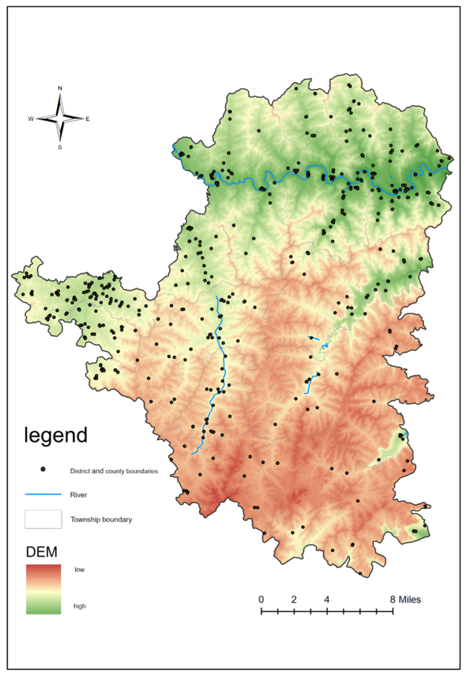
Figure 2.
Bar Chart of Classification Statistics of Cultural Heritage Sites in Pingshun County.
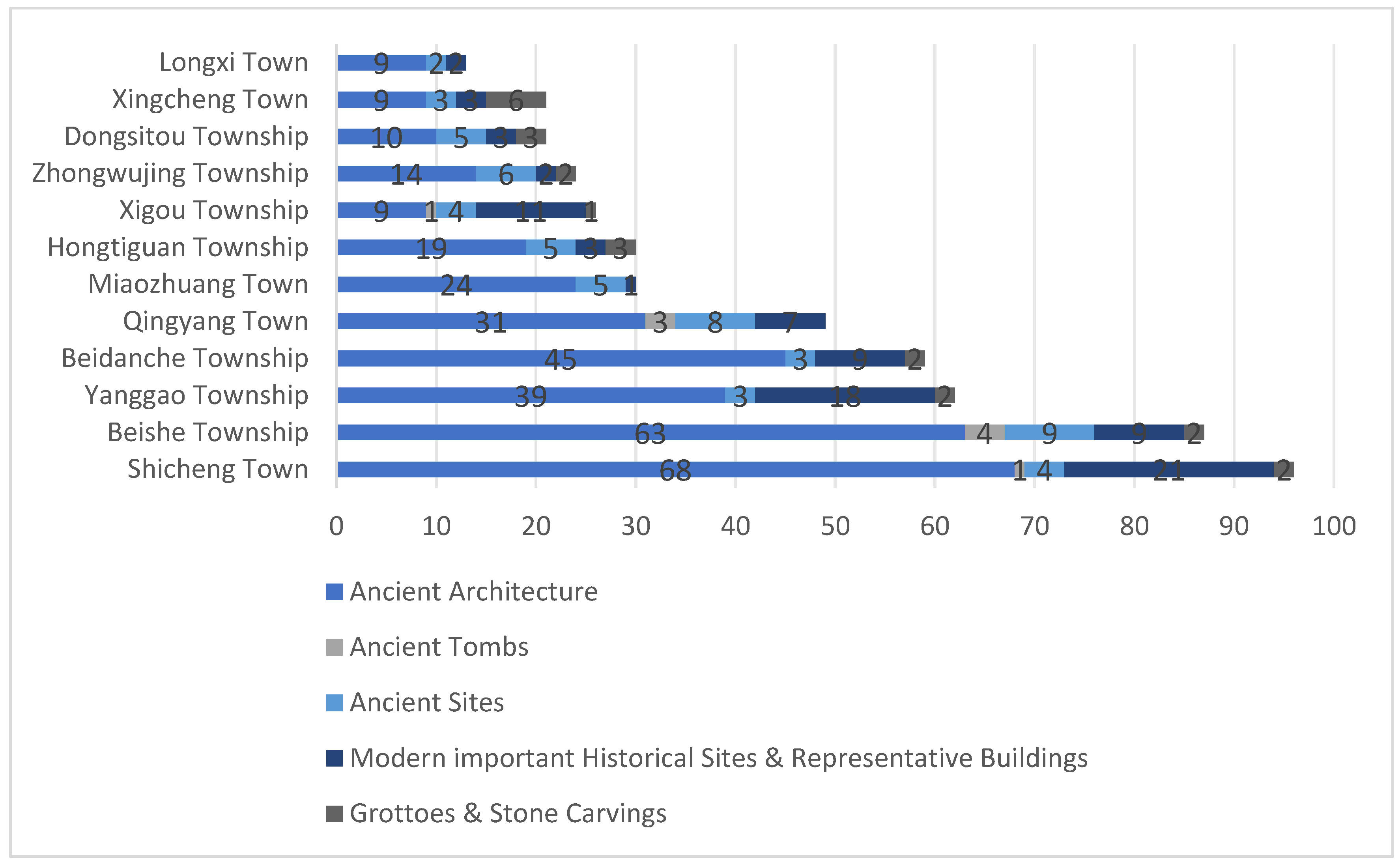
Figure 3.
Kernel-density maps of cultural heritage sites by type in Pingshun County .
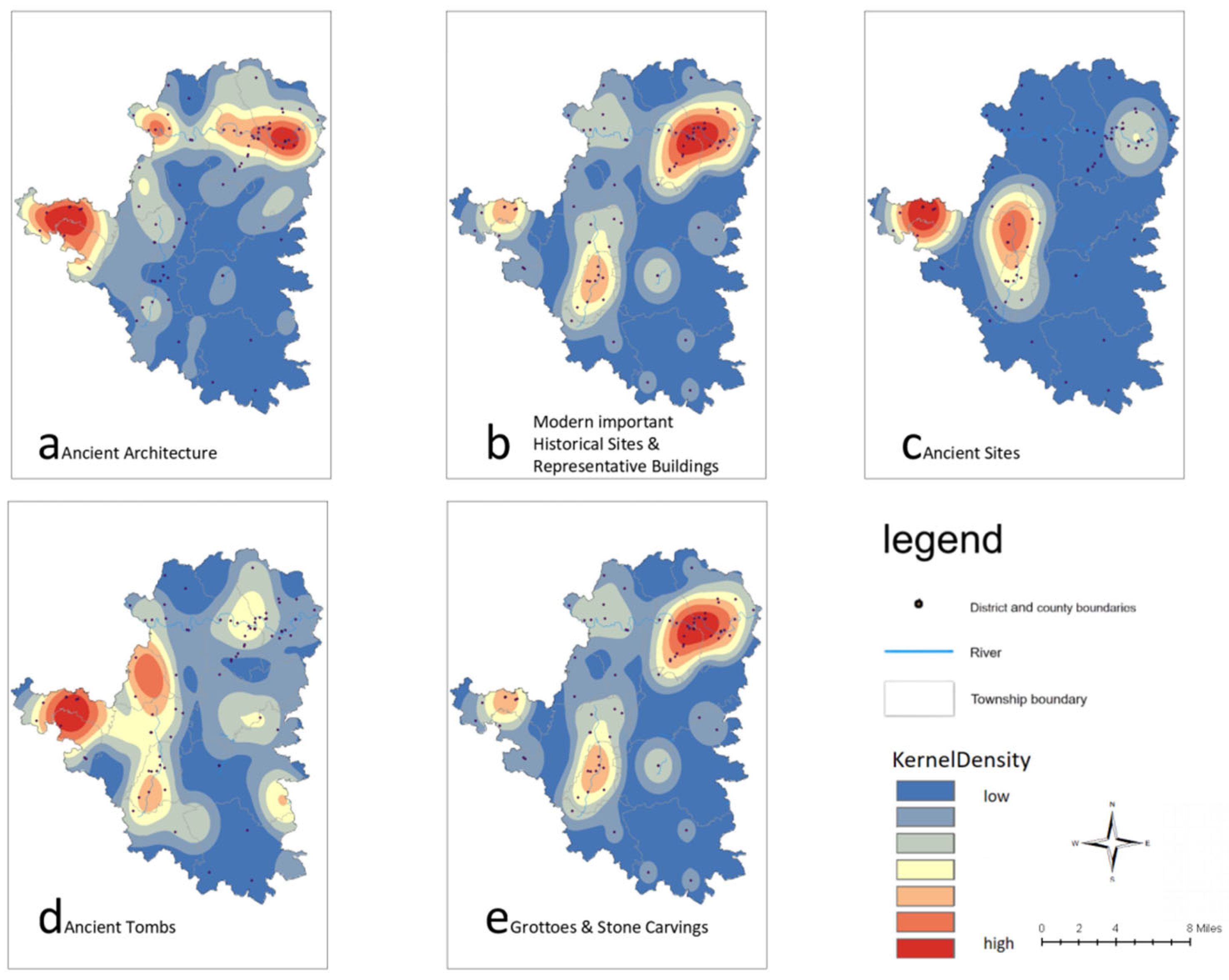
Figure 4.
Bar chart of the historical periods of cultural heritage sites in Pingshun County.
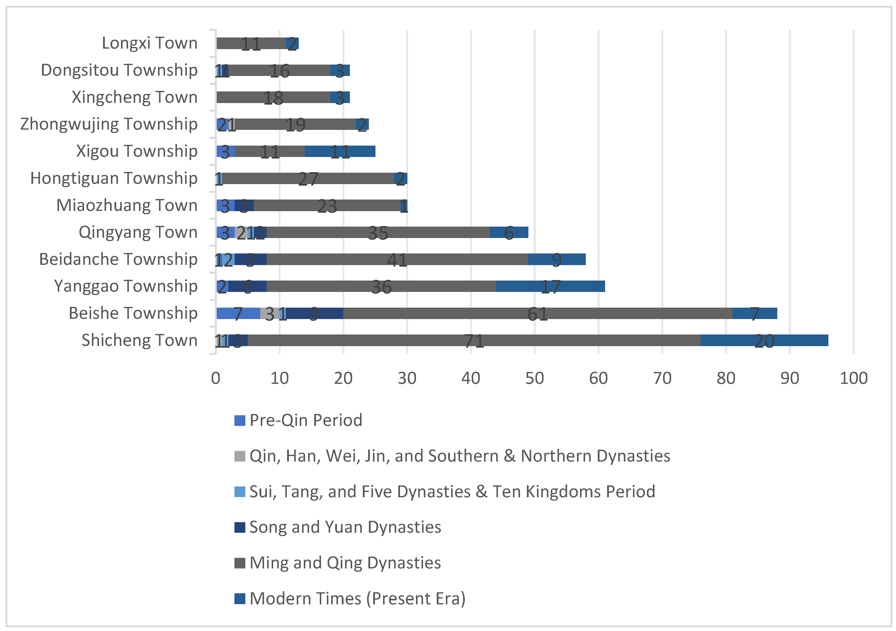
Figure 5.
Line chart of the average nearest neighbor index of cultural heritage sites in Pingshun County over different periods.
Figure 5.
Line chart of the average nearest neighbor index of cultural heritage sites in Pingshun County over different periods.
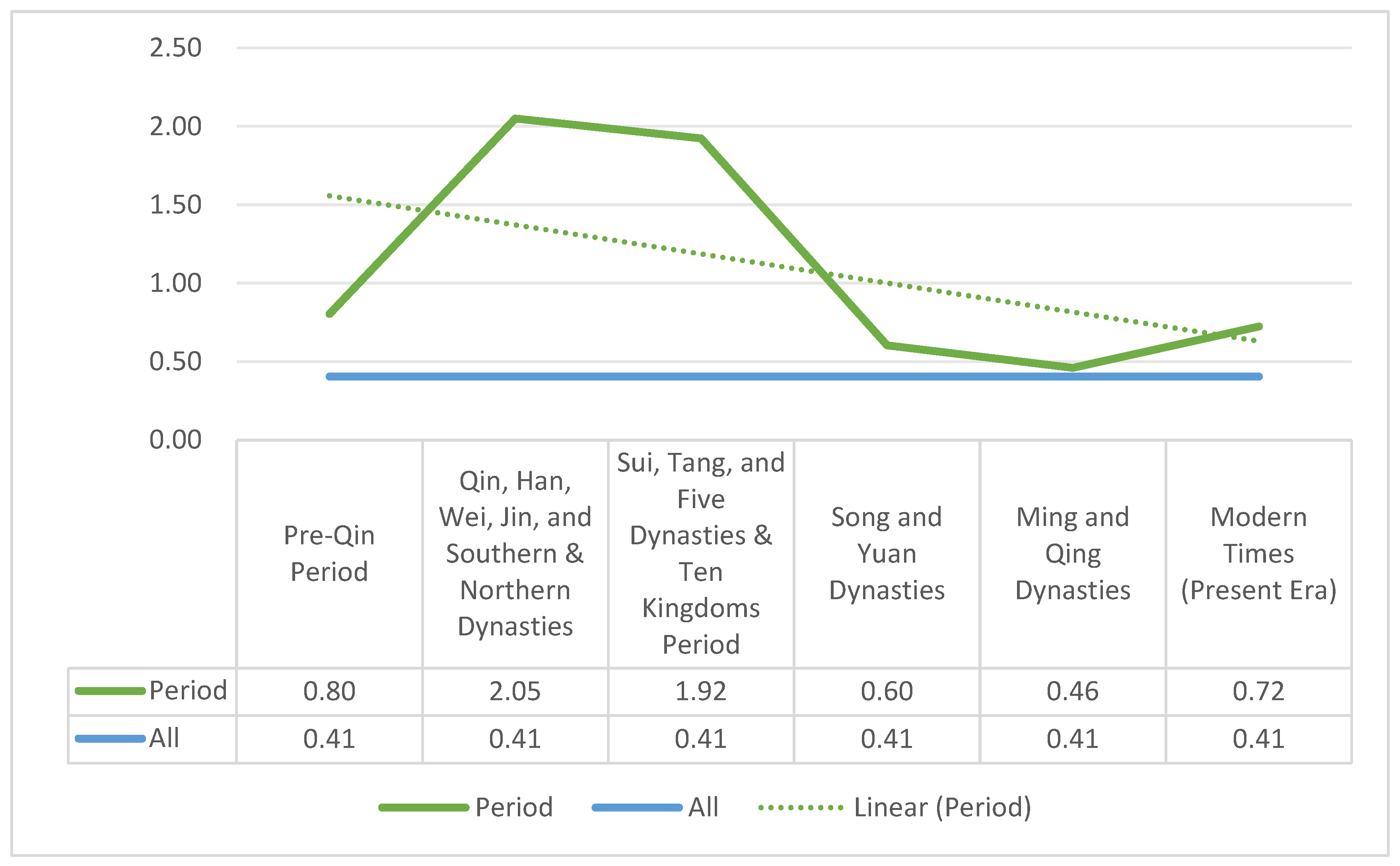
Figure 6.
Kernel density map of cultural heritage sites in Pingshun County.
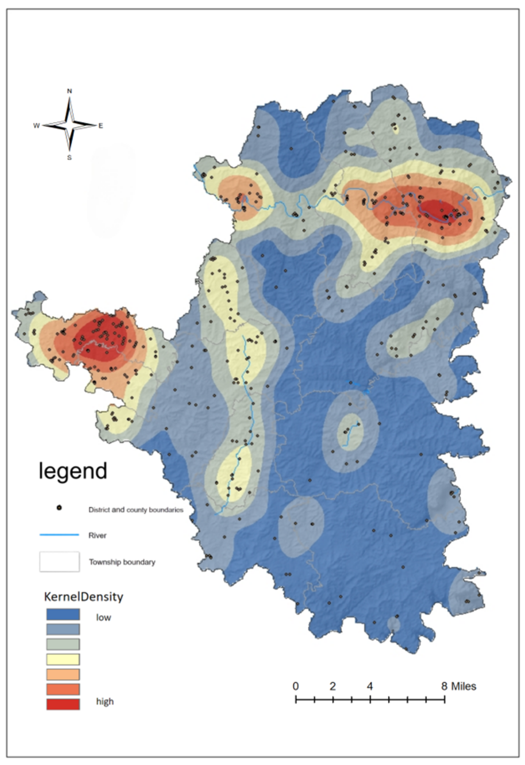
Figure 7.
Kernel Density Map of Cultural Heritage Sites in Pingshun County Across Different Periods.
Figure 7.
Kernel Density Map of Cultural Heritage Sites in Pingshun County Across Different Periods.
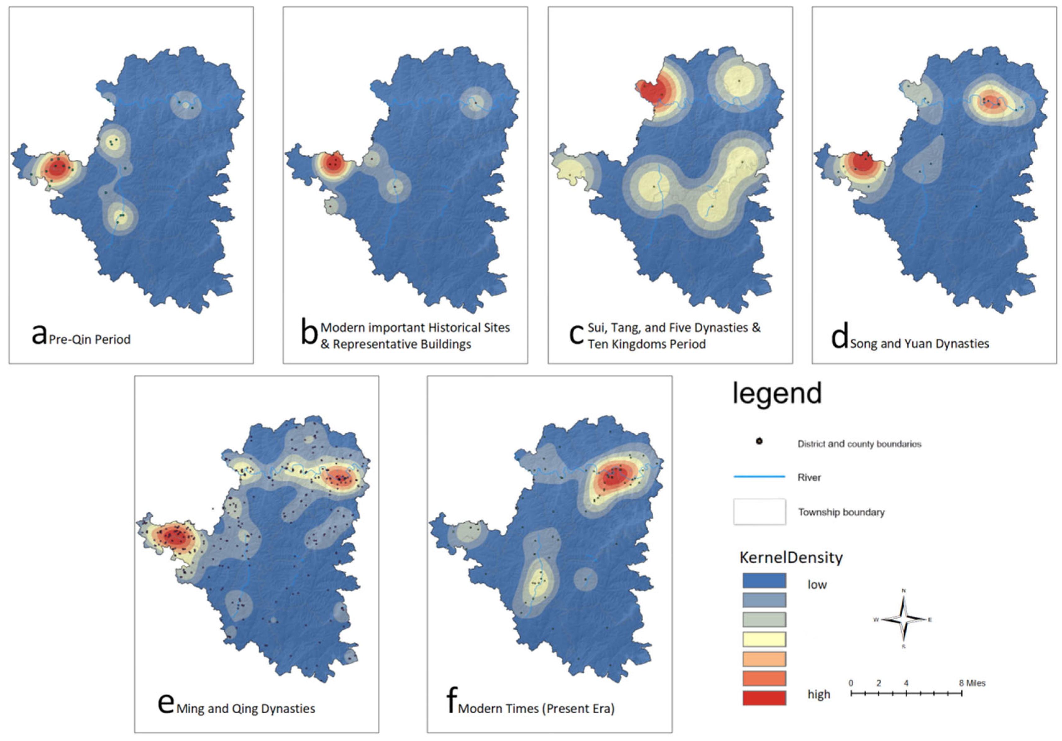
Figure 8.
Standard Deviational Ellipse Distribution Map of Cultural Heritage Sites in Pingshun County Across Different Periods.
Figure 8.
Standard Deviational Ellipse Distribution Map of Cultural Heritage Sites in Pingshun County Across Different Periods.
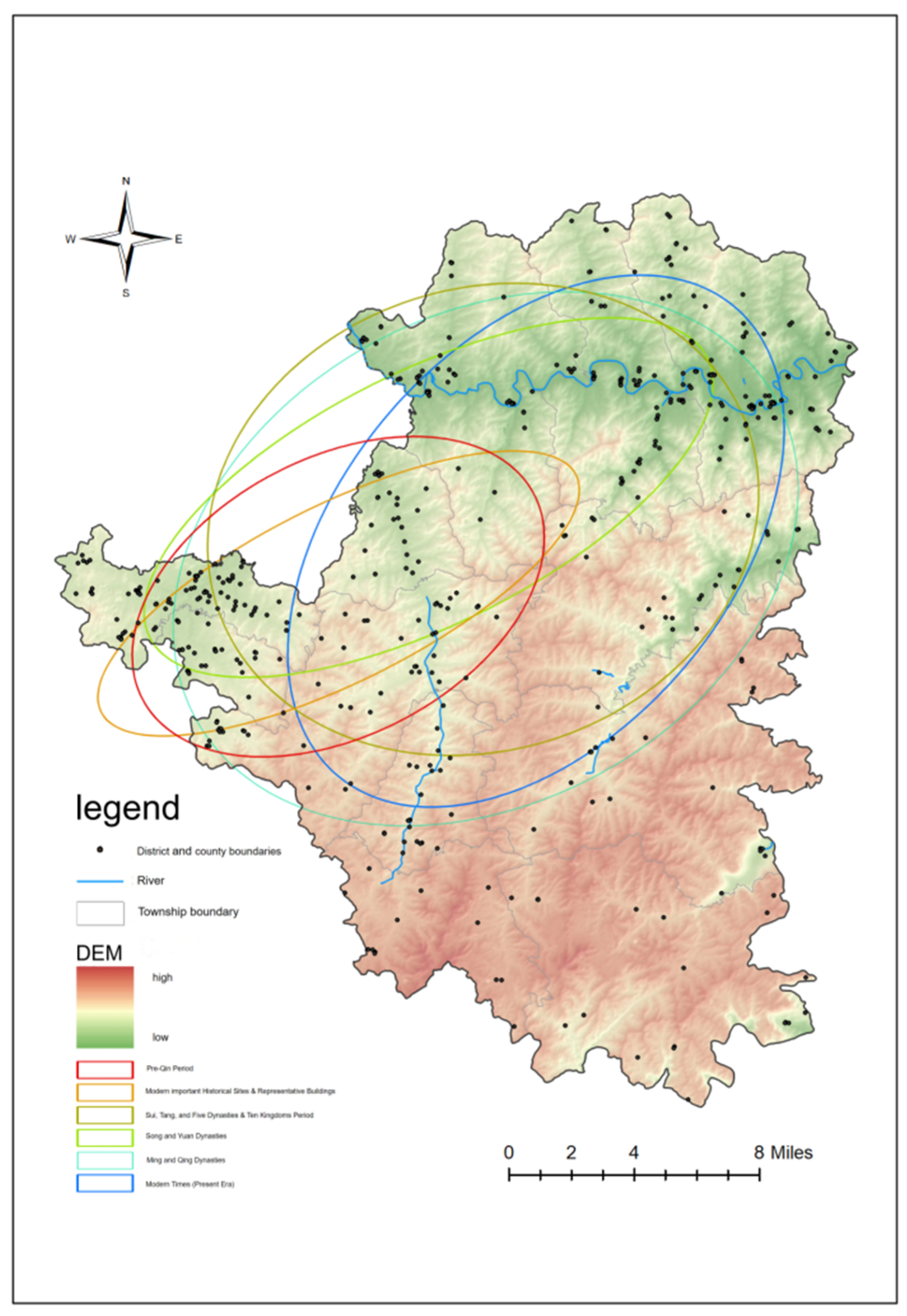

Table 1.
Summary of the Number and Density of Cultural Relics in Each Township of Pingshun County.
| Township | Number (units) | Density(units/km²) |
| Beishe Township | 88 | 1.29 |
| Miaozhuang Town | 30 | 0.89 |
| Shicheng Town | 96 | 0.61 |
| Yanggao Township | 62 | 0.48 |
| Zhongwujing Township | 24 | 0.44 |
| Xigou Township | 26 | 0.42 |
| Beidanche Township | 59 | 0.34 |
| Qingyang Town | 49 | 0.30 |
| Hongtiguan Township | 30 | 0.20 |
| Longxi Town | 13 | 0.14 |
| Xingcheng Town | 21 | 0.11 |
| Dongsitou Township | 22 | 0.09 |
Table 2.
Nearest Neighbor Index of Different Types of Cultural Heritage Sites in Pingshun County.
| Category | Average Observation Distance (km) | Expected Mean Distance (km) | Nearest Neighbor Index | z-score | Study Area(Km2) | Spatial Distribution Type |
| Ancient Architecture | 0.54 | 1.34 | 0.41 | -20.9 | 2433.27 | Clustered |
| Ancient Tombs | 1.49 | 2.28 | 0.65 | -6.27 | 1858.37 | Clustered |
| Ancient Sites | 2.22 | 2.92 | 0.76 | -3.47 | 1945.34 | Clustered |
| Modern important Historical Sites & Representative Buildings | 4.88 | 4.13 | 1.18 | 1.04 | 614.86 | Dispersed |
| Grottoes & Stone Carvings | 5.54 | 4.46 | 1.24 | 2.22 | 1832.64 | Dispersed |
Table 3.
Standard Deviational Ellipse Analysis of Cultural Heritage Sites in Pingshun County.
| period | minor axis(km) | major axis(km) | rotation angle(°) | oblateness |
| Pre-Qin Period | 13.67 | 8.59 | 62.34 | 1.59 |
| Qin, Han, Wei, Jin, and Southern & Northern Dynasties | 16.42 | 5.47 | 63.50 | 3.00 |
| Sui, Tang, and Five Dynasties & Ten Kingdoms Period | 17.32 | 14.27 | 71.71 | 1.21 |
| Song and Yuan Dynasties | 19.30 | 7.80 | 63.34 | 2.47 |
| Ming and Qing Dynasties | 20.49 | 15.05 | 60.78 | 1.36 |
| Modern Times (Present Era) | 12.05 | 19.00 | 40.37 | 0.63 |
Disclaimer/Publisher’s Note: The statements, opinions and data contained in all publications are solely those of the individual author(s) and contributor(s) and not of MDPI and/or the editor(s). MDPI and/or the editor(s) disclaim responsibility for any injury to people or property resulting from any ideas, methods, instructions or products referred to in the content. |
© 2025 by the authors. Licensee MDPI, Basel, Switzerland. This article is an open access article distributed under the terms and conditions of the Creative Commons Attribution (CC BY) license (http://creativecommons.org/licenses/by/4.0/).
Copyright: This open access article is published under a Creative Commons CC BY 4.0 license, which permit the free download, distribution, and reuse, provided that the author and preprint are cited in any reuse.


