Submitted:
02 November 2023
Posted:
03 November 2023
You are already at the latest version
Abstract
Historic sites are important components of every city's cultural history because they preserve rich historical knowledge and distinctive values passed down from previous generations to the present. Due to the progress of urbanization and modernization, many historic sites face pressure from damage and transformation. In this paper, a method for assessing cultural heritage damage was developed to measure the extent of spatial damage in historic sites. Using sample data obtained in Xiyang, Qixian, and Xiaoyi, all historic cities in Shanxi Province, Mainland China, and combined weights were estimated using the Delphi technique and the CRITIC weight method. Following this, the Spatial Damage Degree Model (SDDM) based on K-means cluster analysis and K-nearest neighbor (KNN) classification was developed. The findings show that the model efficiently solves the problem of assessing spatial damage levels in historic sites. Through multiple linear regression analysis, it was shown that the damage to historic sites was predominantly caused by three factors: natural erosion, construction damage, and planning and policy. SDDM was used to calculate the spatial damage levels of historic sites, allowing conservators to fully comprehend the features and concerns related to historic sites. As a result, more scientific and rational preservation approaches may be developed, improving the efficiency of historic site restoration and conservation and encouraging the sustainable development of urban and rural heritage.
Keywords:
historic sites
; spatial damage degree
; K-means clustering
; K nearest neighbor classification
; Damage factors
1. Introduction
By acting as a driving force, urban cultural heritage promotes sustainable urban development [1], and historic sites are equally important components of urban cultural heritage. Renovating historic sites throughout the urbanization process improves the livability and character of cities. Conservation, according to the International Council on Monuments and Sites (ICOMOS), entails developing a location to maintain its “cultural significance” [2]. However, improper protection might result in structural damage within urban historic sites while adaptively utilizing them. Assessing the extent of spatial damage in historic places and putting accurate conservation measures in place is critical for ensuring the long-term development of urban cultural resources.
Historic sites are not just individual structures but also urban and rural landscapes where a distinct culture, major development, and historical events may be uncovered [3]. The notion of historic sites was developed based on this assumption. From the Venice Charter of 1964 to the Washington Charter of 1987, the definition of historic sites grew from “the area surrounding a historic building” to “the large and small areas of historical significance in a town, including the old center of the town and other areas of historical interest” [3,4]. Monuments cannot be divorced from the history they have borne witness to and the environment in which they were conceived or constructed, making research on historic sites highly significant.
Spatial damage degree pertains to the level or extent of damage to the spatial elements within historic sites, encompassing the comprehensive evaluation of damage to buildings, streets, urban fabric, historical environmental elements, and more. When looking at worldwide or global research on this topic, the major focus has been on damage assessment, damage detection technologies, and damage factors affecting historical structures, relics, old city walls, and other cultural treasures. However, there has been little research on the harm to bigger regions, such as historic sites and historic metropolitan centers. Most historic sites study seeks to identify difficulties and provide solutions, but there are no quantitative approaches or indices for assessing the geographical damage degree of historic sites.
Several elements have a role in this. For starters, the study of historic sites encompasses a wide range of disciplines, including architecture, urban planning, sociology, economics, and others, making it more complicated than examining individual monuments. Second, because monuments are physical, it is simpler to detect, measure, document, and monitor their damage. Historic sites, on the other hand, are more abstract, involving spatial architecture, environmental factors, and historical evolution, making it impossible to define and estimate their worth and amount of damage.
There is considerable international research on cultural heritage. Earlier research on the assessment of damage to cultural heritage mainly focused on the post-disaster assessment, mostly after natural disasters [5,6], fires [7], and wars [8,9,10]. This is mainly done by recording the degree and spread of damage to heritage in detail and establishing archives or databases [9,11,12]. In terms of the recognition of damaged heritage, the recognition method has changed from the traditional on-site visual inspection method to intelligent recognition methods such as remote sensing image technology [13,14], UAV technology [15], automatic image processing technology [16] and photogrammetry [17].
In recent years, many scholars have explored the methods of cultural heritage damage assessment [18] and applied them to heritage protection. Zhang (2021) improved the artificial intelligence algorithm to build the CHDA application [19], which accurately locates the damaged areas of cultural heritage by exploring image data posted on social media during disaster events. Tejedor et al. (2022) analyzed the degree of damage to cultural heritage through non-destructive testing (NDT) technology [20,21,22,23,24]. P. Jouan (2019) improved the HBIM model and applied the digital twin (DT) principle to predict threats to heritage integrity through the analysis and simulation of data collected by field sensors and to support site managers in the preventive protection of their assets. Many scholars have proposed to draw the risk map of cultural heritage through WebGIS [25,26] and apply it to the management, monitoring and prediction of cultural heritage. Agapiou (2016) obtained data from remote sensing images, used AHP analysis and cluster analysis to classify more than 150 protected monuments and sites in Paphos, Cyprus, and analyzed the possible natural and man-made threats to them [27].
While research on quantitative assessment methods for cultural heritage damage is emerging, there is limited literature on measurement methods for assessing the extent of damage in the comprehensive context of historic sites. Ultimately, only the calculation and monitoring of the damage degree of cultural heritage cannot provide a sustainable cultural impetus for the sustainable development of urban heritage, and it needs to be extended to the completely historic sites with protection value. Because the cultural elements of historic sites are mainly composed of various types of cultural heritage, the damage factors are more complicated. Therefore, on this basis, this paper draws on previous studies on the assessment of cultural heritage damage, learns assessment methods and ideas, and constructs the spatial damage degree model (SDDM) of historic sites. The model uses a comprehensive evaluation method, cluster analysis, machine learning and multiple linear regression analysis to comprehensively consider the cultural spatial value and damage factors of historic sites; and to a certain extent solve the problems of difficult data acquisition and complicated analysis methods due to the large content of historic sites.
The primary contribution of this study is to broaden the assessment of historical heritage damage from the previous focus on individual buildings to a comprehensive examination of buildings, streets, fabrics, and historical environmental elements within historic sites. This culminates in the establishment of the Spatial Damage Degree Model (SDDM) for historic sites. This was done by learning the previous research methods and ideas to select the methods suitable for establishing the model in this study. The paper mainly focuses on the following issues:
- To explore the method of establishing the index system of measuring the spatial damage degree of historic sites;
- To classify the degree of damage of historic sites units of the three research areas based on K-means clustering analysis;
- Training and testing the clustering results based on the K-nearest neighbor (KNN) classifier;
- Using multiple linear regression equations to analyze the damage factors of historic sites.
2. Materials and Methods
2.1. Data Sources and Study Area
2.1.1. Data Sources
The data collected from the three sample areas in this study is the basis for calculating the spatial damage degree. To ensure data accuracy, scientific validation, and comprehensive coverage, building contour data and road data from the OSM map were combined with field investigations, drone recordings, and the Baidu Street View map (2019). This facilitated investigations and statistical analyses of relevant indicators, including buildings, courtyards, and streets within the plots. Google Maps aided in the study of the spatial evolution process of buildings, streets and fabrics within the plots over the past ten years [14], and the quantitative value of the dynamic index of block damage degree was extracted. The data source is shown in Table 1. Seventy sets of data samples were collected in the three research areas for this study.
2.1.2. Study Area
Three locations were strategically selected for this study. They were Xiyang Ancient City, Xiaoyi ancient City, and Qixian ancient City all in the Shanxi Province. The bases or criteria for their selection are their inherent richness in cultural history and heritage both tangible and intangible. They also include data samples such as buildings, streets, courtyards etc. of different levels of damage degree, which are vital for this study. The location of the research areas is shown in Figure 1.
2.2. Research Methods
To establish the SDDM in this study, data mining and analysis were applied to calculate the spatial damage degree of historic sites in Xiyang Ancient City, Xiaoyi Ancient City and Qixian Ancient City. This model can be used in the future to predict the spatial damage degree of other historic sites.
The research method mainly consists of six steps, which are as follows:
- Constructing an indicator system for measuring spatial damage degree;
- Determining the indicator weights;
- Calculating the comprehensive evaluation value;
- Classifying the damage degree of samples in the research areas through K-means clustering analysis;
- Verifying clustering results using the K-nearest neighbor classifier;
- Using multiple linear regression equations to analyze the damage factors of historic sites.
2.2.1. Step 1: Construction of spatial damage index system
The authenticity and integrity of the historical and cultural space and heritage of a site is what qualifies it to be a historic one. Therefore, it is based on the level of damage to the attributes (integrity and authenticity) of the site that the spatial damage was evaluated. In the process of establishing the indicator system, reference was made to the index system of historic sites from value , the five elements of urban design in the Image of the City [28] and the protection content of historic sites in the Washington Charter [4]. After taking into consideration the reasons for the damage to historic sites and adding a time dimension, the index system of quantifying the spatial damage degree of historic sites was comprehensively constructed.
Generally speaking, the indicators can be divided into two aspects. One is the static indicators extracted from the ontology attributes and representational values of sites, including historical buildings, courtyards, streets and enclosing boundaries. The second is the dynamic index extracted from the perspective of spatial-temporal development, including the fabric evolution after the development and evolution of spatial elements such as buildings and streets.
2.2.2. Step 2: Determine the weight of indicators
This step combined two methods (subjective and objective weights) to make it professional to some extent. The Delphi method and a small group decision-making technique were used in the subjective empowerment, and then a questionnaire survey and interviews were conducted among professionals in other to modify the index system. The objective weighting method used the CRITIC weight method, and assigned weights according to the comparison intensity and conflict of evaluation index values [29]. Finally, the weights obtained by the two methods were synthesized to get the final weight of each index.
- Delphi Method
Delphi is an advisory decision-making technology summarized and proposed by the RAND Corporation in 1964 [30]. Its core objective or framework is to solicit the opinions of experts through several rounds of anonymous correspondence, to find the optimal or satisfactory solution for the group. The questionnaire designed in this study is a 5-point attitude scale, and the higher the score, the more positive the attitude toward the importance of this indicator.
- 2.
- CRITIC weight method
CRITIC (Criteria Importance Through Inter-criteria Correlation) weighting method is a kind of objective empowerment method. It uses a sequence of each value in the standard deviation and coefficient of correlation to determine the index weight [29]. However, in this method, the independence of the data and the preferences of the professional evaluators cannot be reflected in the weights. Therefore, the Delphi method was selected to modify the CRITIC weight method in the index weight determination method.
- 3.
- Multiplicative synthesis
This method multiplied the weights of an indicator obtained by the Delphi method and the CRITIC weight method and then obtained the combined weights according to formula 1.
Note: is the product of the weight obtained by the Delphi method and the weight obtained by the CRITIC weight method, and is the number of indicators.
2.2.3. Step 3: Calculating comprehensive evaluation value
(formula 2) was used to calculate the comprehensive evaluation value based on the weight of the quantitative results of historic sites’ spatial damage. is the basis for subsequent K-means clustering analysis and the establishment of KNN prediction correction models.
Note: is the comprehensive evaluation value, is the combined weight value, is the standardized values of various indicators, and is the number of samples.
2.2.4. Step 4: Classifying the damage degree of samples in the research areas through K-means clustering analysis
The comprehensive evaluation value of each index of each plot on the historic sites obtained through the first three steps is the basic data set for the analysis of the fourth step. Cluster analysis is a method to study individuals according to their characteristics, to classify similar things [31]. The principle is to locate the statistical centroid and group the points closest to a particular centroid (the eigenvector of the unit), which identifies the least square error between the point and the centroid [32]. In this way, the data points within each cluster have relatively similar properties, while the clusters exhibit different characteristics. Due to the randomness of the initial clustering center, the algorithm needed to be iterated until the optimal classification under this operation was generated. The K-means iterative process is as follows:
First, a data matrix was established, and data is randomly was selected as the initial clustering center (, , …, );
Secondly, the cluster number K value was selected according to the elbow rule (Appendix A), and the K value was set as 5 in this study. Then the Euclidean distance algorithm was used to randomly assign each point to the nearest cluster. Finally, each initial cluster center was re-calculated based on the data divided into clusters to generate a new cluster center (formula 3).
where means that there are data in the cluster center , means the TH data in the cluster center , and the iteration continues until it meets the termination condition that the sum of squared errors (formula 4) converges [33]. Then we can get the final clustering center , , …, .
2.2.5. Step 5: Verifying clustering results using K-nearest neighbor (KNN) classifier
The results obtained from the fourth step of clustering analysis are classified into 1-5 levels based on the degree of spatial damage in historical areas, from low to high. The higher the level, the greater the degree of spatial damage. Then K-nearest neighbor (KNN) classifier was used to simulate and verify the classified data. K-nearest neighbor (KNN) classifier is one of the commonly used classifiers in supervised learning [34]. Its principle is to classify the observations as the one with the highest proportion among the K closest observations. In the KNN algorithm, there are three commonly used distances, namely Euclidean distance [35], Manhattan distance [36] and Minkowski distance [37]. Euclidean distance was adopted in this study. Let be an input sample with p features, n is the total number of input samples, and p is the total number of features, then the Euclidean distance between and is:
The K-nearest neighbor (KNN) classifier divided the sample data into training data sets and test data sets, using class labels after the previous clustering algorithm, and is a “supervised” classification method. In the training process, the real category of each training sample is used to train the classifier, while in the testing process, the classifier is used to predict the category of each test sample [34]. The performance and accuracy of the KNN classifier depend on the choice of K value and the distance measure applied. In this study, the cross-validation method [34] was adopted to select the optimal K value.
2.2.6. Step 6: Researching method of damage factors of historic sites: multiple linear regression analysis
Multiple linear regression analysis is a statistical analysis method used to determine the interdependent quantitative relationship between two or more variables. Its core is to use multiple independent variables to jointly predict or estimate the trend of dependent variables [38]. Therefore, to clarify the damage factors and study the influence of the various factors on the spatial damage degree of historic sites, a multiple linear regression model was selected to analyze the influencing factors. The model equation is as follows (formula 6):
where, is the dependent variable, representing the degree of spatial damage in historic sites; , , …, is a series of factors affecting the spatial damage degree of historic sites; , , , …, is the regression coefficient, is the error term.
3. Results
3.1. Index System and Weight
3.1.1. Index system
According to the relevant content of the Washington Charter on the protection of historical sites; determining indicators for evaluating the degree of spatial damage in historical sites. A total of 11 indicators were identified in this study. The data of 7 indicators which include building roof damage degree, building dimension contradiction rate, damage degree of courtyard form, street scale damage degree, street continuity, enclosing boundary survivability and fabric evolution degree, were obtained from Google Maps. The data for the two indicators of building structural damage degree and building function change rate mainly came from field investigation. The two index data of building feature damage degree and street coordination were obtained from the comprehensive evaluation of the Baidu Street View map, UAV and field investigation. Moreover, the data acquisition of building feature damage degree and street coordination mainly relied on the observation method.
The specific indicator data organization table is shown in Appendix C, and the definition and calculation of indicators are shown in Appendix B.
3.1.2. Weight Determination
Table 2 shows the combined weights of each index. From the table, the synthesis method uses the Delphi method to modify the weight from the CRITIC method to get a more realistic weight. Building feature is an index that can most directly reflect the damage situation in the evaluation system because its weight is the largest, 0.308. Courtyard form and street coordination follow in the second and third positions with weights of 0.222 and 0.186, respectively. The enclosed boundary mainly exists around the historic sites. At present, there are few relics of the ancient city walls, moats, and other surrounding boundaries, so their weight is also relatively large. The building function does not directly relate to the spatial damage of historic sites, so the weight is the smallest.
3.2. Results of Cluster Analysis
According to the comprehensive evaluation value , the collected sample plots were divided into five clusters. Due to the randomness of the initial statistical centroid in clustering analysis, multiple analyses were conducted and validated by KNN classifiers, resulting in the highest accuracy set of classifications for constructing the SDDM. The process was finalized when there was no change in the cluster center or only a small change; the maximum absolute coordinate change of any centers are 0.000. It took six iterations to get the optimum result. The study included 70 sets of historic site data graded from one to five representing damage degrees from low to high. The segregations were made up of 22 sections in the first degree of damage, 26 sections in the second degree of damage, 14 sections in the third degree of damage, 7 sections in the fourth degree of damage, and 1 section in the fifth degree of damage. The clustering results are shown in Figure 2.
In general, the distribution of spatial damage degree of the plots in the historic sites are as follows: low degree of damage in the middle and high degree of damage in the surrounding areas; thus in a circular pattern, it increases outwards. In other words, the core spatial of the historic sites are less damaged, and various types of heritage are well preserved. The extent of damage to the boundary of historical areas is relatively high, and there are many demolitions. There is a significant difference in volume and style between newly built buildings and historical buildings.
In detail, the northern part of Xiyang Ancient City has a high degree of damage with one plot with a grade-5 damage degree. The main feature is that over 90% of the historical buildings in the plot have been demolished, and the scale and structure of the newly built buildings have undergone significant changes. The existing architectural style is seriously inconsistent with the historical architectural style.
There are other two damaged plots with grade 4 in the ancient city of Xiyang, mainly located in the north. There are 5 plots with grade-4 damage degree in the ancient city of Qixian, which are distributed across the northern and southern border areas. The plots with grade-4 damage degrees are characterized by the demolition of more than 60% of historical buildings, great damage to the fabric and a considerable number of modern-style buildings. Although several historical buildings have been preserved to a certain extent, the building quality is poor and with a general appearance, the street coordination degree and continuity are low, and the building function has changed greatly.
There is a grade-3 damaged plot located in the northwest corner of the ancient city of Xiyang. There are 13 plots with grade-3 damage degree in the Xiaoyi Ancient City, located at the northern and southern edges of the ancient city and in the middle of the western side. The main manifestation of the third level of damage is that the fabric of the land is still the same, the degree of damage to the courtyard structure is small, and the building dimension is the same as that of ancient buildings. Modern-style buildings account for a large proportion of the total building area, while historical buildings with poor appearance account for 30% -60% of the total area. Largely, the plots with a third level of damage consist of renovated individual residences, and the building function is mainly residential. The buildings are of good quality but poor appearance with low coordination between streets and alleys.
There are 8 grade-2 damaged plots in the Xiyang Ancient City, accounting for 60% of the total plots, and they are located in the middle and south of the ancient city. There are 12 grade-2 damaged plots in Xiaoyi Ancient City, mainly in the east and north of the third-level damaged plots. There are 6 second-level damage plots in the Qixian ancient city, mainly in the four corners of the ancient city. The plots with second-degree damage have the fabric and style same as the historical ones, and the form of the courtyards is well preserved, but 20%-30% of the building volume and function have changed and with poor features. The overall style of the grade-2 damaged plots is more coordinated, the street continuity is higher, and the building scale is appropriate. Although a few modern-style buildings may have a certain damage to the integrity and authenticity.
There is 1 grade-1 damaged plot in Xiyang Ancient City, 10 grade-1 damaged plots in Xiaoyi Ancient City, and 11 grade-1 damaged plots in Qixian Ancient City, all of which are located in the center of the ancient cities. The sites with grade-1 damage degree are mainly characterized by intact building fabric preservation, appropriate scale, buildings with poor style accounting for less than 20% of the total construction area, well-coordinated overall style, and well-preserved courtyard form. Although the overall damage degree is small, the building components such as doors and Windows, interior decoration, etc. are not fully protected, which is the key content to be protected and improved in the future.
In general, the ancient city of Qixian has the best preservation degree and the least damage degree, while the ancient city of Xiyang has the greatest damage degree. The damage degree classification of the three historic sites in this study area is relatively concentrated, as shown in Figure 3.
3.3. KNN Verification Analysis Results
Through the K-nearest neighbor (KNN) classifier, the data was divided into a 70% training set and a 30% validation set, and the model evaluation results were obtained. Table 3 shows the prediction evaluation indicators of the training set and testing set, and measures the prediction effect of K-nearest neighbor (KNN) through quantitative indicators. Among them, the hyper parameters can be adjusted continuously through the evaluation index of the cross-validation set, and a reliable and stable model can be obtained.
Per the results in Table 3, the proportion of the predicted correct samples accounted for 81% of the total samples. For the results of the actual positive samples, the proportion of predicted positive samples, thus, the recall rate was 81%, the accuracy rate was 69.5%, and the harmonic average of the accuracy rate and the recall rate was 73.8%. In the future, the results obtained by the K-nearest neighbor (KNN) classifier can be used as a reference to accurately protect small plots in historic sites.
3.4. Linear Regression Analysis Results
In the regression analysis, the index established in Step 1 is divided into four dimensions: building component, feature and form, building land use and building fabric. According to the analysis, the significance of multiple linear regression is 0.000, indicating that there is a significant linear relationship between the model and the spatial damage degree of historic sites, which is conducive to further research on the damage factors of historic sites. According to the significance results, the influence degree of each variable in descending order is as follows:
Enclosing boundary survivability (X8)
Street coordination (X5)
Building feature (X3)
Street continuity (X11)
Fabric evolution (X9)
Building function (X7)
Building roof (X1)
Building structure (X2)
Courtyard form (X4)
Street scale (X10)
Building dimension (X6).
The significance of enclosing boundary survivability (X8), street coordination (X5) and building feature (X3) are all less than 0.05, indicating that these three indexes have the greatest impact on the damage of historic sites. The significance of the five indexes of street continuity (X11), fabric evolution (X9), building function (X7), building roof (X1) and building structure (X2) are all less than 0.5, indicating that the damage to the historic sites is not significant, but has a certain explanatory role. The three factors of courtyard form (X4), street scale (X10) and building dimension (X6) are not significant. The results are shown in Table 4.
4. Discussion
4.1. Application and Deficiency of SDDM
4.1.1. Application of SDDM
Through field investigation and map observation of Xiyang, Xiaoyi and Qixian ancient cities, the basic data sample required for the establishment of the comprehensive model (SDDM) has been obtained. Matlab can be used to write the instruction codes for all kinds of data under the established index system, including various index algorithms, weight calculation and clustering algorithms. By collecting the data in Appendix C and following the calculation method in Appendix B, other historic sites can use SDDM to determine the level of damage to the target plot, thus developing targeted update and renovation strategies. Below are some of the applications of the SDDM.
- Conservation Planning: SDDM can more comprehensively assess the extent of spatial damage in historic sites. The introduction of this comprehensive protection concept will help the protectors grasp the characteristics and problems of the historic sites more comprehensively. By analyzing the degree of damage to different historic sites, we can understand the impact of different decisions on historical heritage and choose the most appropriate scheme.
- Repair Guidance: SDDM can be used to prioritize and scope repair works. By assessing the extent of spatial damage in historic sites, it is possible to determine which parts need to be prioritized for repairs, as well as the extent and method of restoration. This helps ensure the effectiveness and sustainability of the restoration work.
4.1.2. Shortcomings and Improvement Direction of SDDM
- The objectivity of data collection needs to be strengthened.
The spatial damage degree model (SDDM) of historic sites lacks quantitative data support. Because some indexes such as the damage degree of building features and the coordination degree of streets are determined by subjective evaluation. There is some subjectivity and uncertainty in the practical application process. To improve the reliability and scientific proof of the model, it is necessary to establish a set of systematic data acquisition and analysis methods to obtain more accurate and objective damage-evaluation standards.
- 2.
- Maintenance and repair should be taken into account.
The spatial damage degree model (SDDM) of historic sites does not consider their maintenance and restoration. The extent of damage to historic sites is not only related to their past damage but also to their maintenance and restoration. Therefore, it is necessary to introduce the maintenance and restoration of historic sites as evaluation indicators and combine the heritage assessment method (HIA) [39] to evaluate the damage degree of historic sites more comprehensively.
- 3.
- The information and database of the system need to be sorted out.
The spatial damage degree model (SDDM) of historic sites lacks a comprehensive reference database in practical application. The evaluation of the damage degree of historic sites is a complicated process therefore needs lots of reference data to support it. However, the accuracy of the evaluation results is limited by the lack of detailed reference data in the current model of historic site damage degree. Therefore, one of the directions of improvement is to establish a comprehensive reference database and collect and collate the relevant information of historic sites, to provide for the use of evaluation models.
4.2. Study on the Influencing Factors of Spatial Damage in Historic Sites
The evolution of historical and cultural spatial forms is the result of several subjective and objective factors. In different periods, various dynamic factors have different effects on historical and cultural spatial forms.
4.2.1. Natural erosion
Natural erosion is one of the important reasons for the damage to cultural elements in historic sites. Natural erosion includes natural disasters, environmental pollution and time erosion.
Natural disasters such as strong winds and heavy rains may cause the shingles or the connecting parts of the roof of the building to fall off, reducing the waterproof performance of the roof, and resulting in water leakage. Earthquakes can cause instantaneous damage to building structures. Environmental pollution will directly damage the material structure of cultural heritage. In the urban environment, air pollutants will react with the surface of the building, causing stone and metal corrosion, so that the appearance and structure of the buildings are damaged[40]. With the passage of time and environmental pollution, building materials will age and corrode [41]. Weeds on the roof of a building are the main cause of structural damage to the roof.
The results show that the plots with the highest degree of roof damage in Xiyang Ancient City account for 15% of the total roofs, 80% of which are destroyed by weeds. The plots with the highest degree of roof damage in Xiaoyi Ancient City account for 25% of the total roof damage, of which 60% is caused by natural erosion and 40% by human factors. The plots with the highest degree of roof damage in the ancient city of Qixian account for 13% of the total roof damage, 90% of which is caused by natural factors.
4.2.2. Construction damage
Aspects of human development deemed positive and progressive—construction, cultivation, and expansion—equally threaten the longevity and security of cultural heritage [42]. For example, in the process of urban renewal, large-scale demolition, reconstruction, and renovation of historic sites have been carried out to enhance the city’s image and economic efficiency. To increase the utilization rate and development potential of land in the land development market, the historical buildings with old-fashioned uses that do not meet the needs of modern society were demolished and reconstructed to improve the plot area ratio. This led to the emergence of modern buildings in the originally continuous streets, changed the architectural function and style, and destroyed the integrity and continuity of the historic sites. To meet the traffic needs and economic interests, many streets in historic sites, such as the main streets of the ancient city of Xiyang were rebuilt into wide straight streets or shopping centers, resulting in the disappearance of the original zigzag fabric and the streets became monotonous.
Furthermore, In the process of urbanization, the population increases dramatically, requiring the development of new land, and the construction of new buildings and infrastructure, which often leads to the destruction of the fabric of historic sites. The original historical buildings on the northeast side of Xiyang Ancient City were demolished and replaced by high-rise residential buildings. The old and new buildings were not in harmony, and the fabric and style of the ancient city were seriously separated. A large number of historical buildings have also been demolished in the northwest corner of the ancient city of Qixian, and the continuity of the whole plot has been seriously damaged. Due to the improper measures in the protection planning of Xiaoyi Ancient City, the original buildings with better features in the western district of the county government were demolished and rebuilt, which failed to continue the fabric of the ancient city. As shown in Figure 4.
4.2.3. Planning and Policy
Imperfect policies and regulations are also one of the main reasons for the damage to historic sites. Large-scale urban renewal or reconstruction under the guidance of policy will cause serious damage to the style and fabric of historic sites. The large number of tourists brought by the development of tourism has also put pressure on the protection of the environment and buildings in historic sites. In addition, if the punishment for illegal construction is insufficient or the regulatory authorities are ineffective, historic sites will also suffer irreversible damage, including the destruction of the original pattern and changes in the historical environment. The prominent characteristics of this type of damage are (1) Significant changes in the fabric of historic sites; (2) Severe damage to the reconstruction of buildings along the street; (3) Part of the plots are demolished for public space.
5. Conclusions
The study established a comprehensive model (SDDM) for measuring the spatial damage degree of historic sites through the Delphi method, CRITIC weight method, K-means clustering analysis, and K-nearest neighbor (KNN) classification method. Multiple linear regression analysis was used to study the factors of spatial damage in historic sites. The main conclusions are as follows:
- The establishment of a spatial damage degree model (SDDM) of historic sites is an innovation to the traditional conservation work. The model can not only accurately assess the spatial damage degree of historic sites and formulate accurate protection strategies, but also fill the blank in the field of quantifying the spatial damage degree of historic sites.
- In the study area, the spatial damage degree tended to be higher around and lower in the middle. The core areas of the three research regions are mostly first-degree damaged plots, and a few are second-degree damaged plots. Most of the four and five-degree damaged plots are around the boundaries. The third-degree damaged plots are located outside the first and second-degree damaged plots. In terms of the number of plots in damage degrees, degree level five (5) is the least, followed by degree level four (4). Degree levels three (3) and two (2) followed in that order with degree level one (1) being the most.
- The coupling interaction of multiple factors such as natural erosion, construction damage, planning and policy affects the spatial damage degree of historic sites. Natural erosion mainly includes natural disasters, environmental pollution, and time erosion, and its damage to historic sites is objective. The damage of construction is mainly caused by the residents’ lack of consciousness and improper urban renewal, which is subjective. Improper planning and lack of policies have a great impact on the spatial damage of historic sites, which determines the compliance and legitimacy of historic site protection, and is the main direction to be improved in the future.
- In the future, the spatial damage degree model (SDDM) of historic sites can be introduced into urban physical examination assessment and urban renewal. It can be used to formulate rational conservation strategies, prioritize urban renewal, and monitor restoration effects.
Author Contributions
All authors contributed to the paper. W.H. proposed the idea of this article and was responsible for reviewing and editing it. B.Z. was responsible for writing and data analysis. All authors have read and agreed to the published version of the manuscript.
Funding
This research was supported by the Shanxi Provincial Natural Science Research Project (grant number: 202203021211171), and the Provincial Education Reform Project (grant number: RC2300003661).
Institutional Review Board Statement
Not applicable.
Informed Consent Statement
Not applicable.
Data Availability Statement
Not applicable.
Conflicts of Interest
The authors declare no conflict of interest.
Appendix A
Elbow Rule is a method used to help select the optimal number of clusters in cluster analysis, determined by plotting the sum of squares of error (SSE) corresponding to the different number of clusters. After obtaining the inflection point range by elbow rule, KNN is used to calculate the accuracy of model training under each K value. Finally, it is verified that the accuracy is the highest when K value is 5.
Appendix B

Table A1.
Calculation method and connotation of indicators.
| Index Classification | Pattern attribute | Index Name | Index Definition | Symbolic representation and calculation method | Index annotation |
| Static index | Buildings (Node) | Building roof damage degree | The degree of damage to the roof of a building | is the weight of roofs with different degrees of damage | |
| Building structural damage degree | The proportion of the number of buildings with structural damage to the total number of buildings | is the total number of roofs within the plot | |||
| Building feature damage degree | Weighted summation of the proportion of the land area of buildings with different styles and features to the total building area of the entire plot | is the weight of buildings with different styles and features | |||
| Building function change rate | The proportion of buildings with changed functions to the total number of buildings | is the total number of buildings within the plot | |||
| Building dimenssion contradiction$$$rate | The proportion of uncoordinated building area in total building area | is the total base area of buildings within the plot | |||
| Courtyard(Node) | Damage degree of courtyard form | The proportion of different degrees of collapsed courtyards to the total number of courtyards | is the weight of courtyards with different degrees of damage | ||
| Street system(Path) | Street scale damage degree | Absolute value of the difference between the width to height ratio of main streets and historical street standard values | is the standard aspect ratio of historical streets and alleys | ||
| Street coordination | The coordination degree of the main street and alley facades in terms of style and appearance | is the coordination degree of the facade style of the main streets and alleys in the i-th plot | |||
| Street continuity | Main Street thread adhesion rate | is the length of the centerline of the street and alley | |||
| Boundary(Edge) | Enclosing boundary survivability | Comparing historical data, the remains of authentic city walls, green belts, rivers and other surrounding boundaries in the block | is the remaining situation of the i-th plot’s enclosing boundary | ||
| Dynamic index | Evolution(Domain) | Architectural evolution degree | Compare the historical buildings of the plot in historical data, overlap them with the current historical buildings, and determine the degree of preservation of the historical buildings | is the base area of historical buildings within the plot | |
| Evolution degree of streets | Compare the road network system of the plot in historical data, overlap it with the current road network, and determine the degree of preservation of the historical road network | is the area of past streets and alleys within the plot | |||
| Fabric evolution degree | The sum of architectural evolution and street evolution | TE=|AE-1|+|SE-1| | AE is the degree of architectural evolution; SE is the degree of evolution of streets |
Appendix C
Table A2.
Sample table for collecting research data on historic Sites.
| Total courtyard quantity | ||
| Total building quantity | ||
| Fabric evolution | Street evolution | |
| Building evolution | ||
| Enclosing boundary survivability | Score | |
| Street continuity | Score | |
| Street coordination | Score | |
| Street scale | Score | |
| Courtyard form | Score | |
| Weight | 1 | |
| 0/4 | ||
| Weight | 3 | |
| 1/4 | ||
| Weight | 5 | |
| 2/4 | ||
| Weight | 7 | |
| 3/4 | ||
| Weight | 9 | |
| 4/4 | ||
| Building volume | Score | |
| Building function | Score | |
| Building feature | Score | |
| Weight | 1 | |
| Poor | ||
| Weight | 3 | |
| Fair | ||
| Weight | 5 | |
| Average | ||
| Weight | 7 | |
| Good | ||
| Weight | 9 | |
| Excellent | ||
| Building structure | Score | |
| Building roof | Score | |
| Weight | 3 | |
| Proportion of dilapidated roofs | ||
| Weight | 6 | |
| Proportion of intact roofs in residential buildings | ||
| Weight | 9 | |
| Proportion of intact ancient building roofs | ||
References
- Resolution, G. A. J. U. D. A. R., Transforming our world: the 2030 Agenda for Sustainable Development. 2015.
- Glendinning, M., The conservation movement: a history of architectural preservation: antiquity to modernity. Routledge: 2013.
- Charter, V. In International charter for the conservation and restoration of monuments and sites,(ICOMOS), Proceedings of the 2nd international congress of architects and technicians oh historical monuments. Venice, Italy, 1964; 1964.
- Charter, W. J. A. b. I. G. A., Charter for the conservation of historic towns and urban areas. 1987.
- Bonazza, A.; Sardella, A. J. H., Climate Change and Cultural Heritage: Methods and Approaches for Damage and Risk Assessment Addressed to a Practical Application. 2023, 6, 3578-3589. [CrossRef]
- Meyer, D.; Hess, M.; Lo, E.; Wittich, C. E.; Hutchinson, T. C.; Kuester, F. In UAV-based post disaster assessment of cultural heritage sites following the 2014 South Napa Earthquake, 2015 Digital heritage, 2015; IEEE: 2015; pp 421-424.
- Salazar, L. G. F.; Romão, X.; Paupério, E. J. I. J. o. D. R. R., Review of vulnerability indicators for fire risk assessment in cultural heritage. 2021, 60, 102286. [CrossRef]
- Stein, G. J. J. N. E. A. The war-ravaged cultural heritage of Afghanistan: an overview of projects of assessment, mitigation, and preservation. 2015, 78, 187-195. [CrossRef]
- Isakhan, B. J. I. J. o. H. S. Creating the Iraq cultural property destruction database: calculating a heritage destruction index. 2015, 21, 1-21. [CrossRef]
- Vecvagars, K. Valuing damage and losses in cultural assets after a disaster: concept paper and research options. ECLAC: 2006.
- Vafadari, A.; Philip, G.; Jennings, R. J. T. I. A. o. t. P., Remote Sensing; Sciences, S. I., Damage assessment and monitoring of cultural heritage places in a disaster and post-disaster event–a case study of Syria. 2017, 42, 695-701. [CrossRef]
- Karataş, L.; Ateş, T.; Alptekin, A.; Dal, M.; Yakar, M. J. A. E. S. A systematic method for post-earthquake damage assessment: Case study of the Antep Castle, Türkiye. 2023, 3, 62-71.
- Tapete, D.; Cigna, F. J. J. o. A. S. R. Trends and perspectives of space-borne SAR remote sensing for archaeological landscape and cultural heritage applications. 2017, 14, 716-726. [CrossRef]
- Luo, L.; Wang, X.; Guo, H.; Lasaponara, R.; Shi, P.; Bachagha, N.; Li, L.; Yao, Y.; Masini, N.; Chen, F. J. R. S. Google Earth as a powerful tool for archaeological and cultural heritage applications: A review. 2018, 10, 1558. [CrossRef]
- Baranwal, E.; Seth, P.; Pande, H.; Raghavendra, S.; Kushwaha, S. In Application of unmanned aerial vehicle (UAV) for damage assessment of a cultural heritage monument, Proceedings of UASG 2019: Unmanned Aerial System in Geomatics 1, 2020; Springer: 2020; pp 123-131.
- Cerra, D.; Plank, S.; Lysandrou, V.; Tian, J. J. R. S. Cultural heritage sites in danger—towards automatic damage detection from space. 2016, 8, 781. [CrossRef]
- Randazzo, L.; Collina, M.; Ricca, M.; Barbieri, L.; Bruno, F.; Arcudi, A.; La Russa, M. F. J. S. Damage indices and photogrammetry for decay assessment of stone-built cultural heritage: The case study of the San Domenico church main entrance portal (South Calabria, Italy). 2020, 12, 5198. [CrossRef]
- Romao, X.; Pauperio, E. J. I. J. o. A. H. An indicator for post-disaster economic loss valuation of impacts on cultural heritage. 2021, 15, 678-697. [CrossRef]
- Zhang, Y.; Zong, R.; Kou, Z.; Shang, L.; Wang, D. J. I. T. o. C. S. S. Collablearn: An uncertainty-aware crowd-AI collaboration system for cultural heritage damage assessment. 2021, 9, 1515-1529. [CrossRef]
- Diz-Mellado, E.; Mascort-Albea, E. J.; Romero-Hernández, R.; Galán-Marín, C.; Rivera-Gómez, C.; Ruiz-Jaramillo, J.; Jaramillo-Morilla, A. J. J. o. B. E. Non-destructive testing and Finite Element Method integrated procedure for heritage diagnosis: The Seville Cathedral case study. 2021, 37, 102134. [CrossRef]
- Tejedor, B.; Lucchi, E.; Bienvenido-Huertas, D.; Nardi, I. J. E.; Buildings, Non-destructive techniques (NDT) for the diagnosis of heritage buildings: Traditional procedures and futures perspectives. 2022, 263, 112029. [CrossRef]
- Gil, E.; Mas, Á.; Lerma, C.; Torner, M. E.; Vercher, J. J. I. J. o. A. H. Non-destructive techniques methodologies for the detection of ancient structures under heritage buildings. 2021, 15, 1457-1473. [CrossRef]
- Pehlivan, G. F. J. A.; Planning, U. Analysis of Cultural Heritage by Non-Destructive Methods: The Case of Sivas Congress Museum. 2023, 19, 1-16.
- Işık, N.; Halifeoğlu, F. M.; Ipek, S. J. C.; Materials, B. Nondestructive testing techniques to evaluate the structural damage of historical city walls. 2020, 253, 119228. [CrossRef]
- Accardo, G.; Giani, E.; Giovagnoli, A. J. J. o. a. c. The risk map of Italian cultural heritage. 2003, 9, 41-57. [CrossRef]
- Li, Q.; Liu, M.; Song, J.; Du, Y.; Gao, F. J. S. The Risk Map of Cross-Regional Cultural Heritage: From a Perspective of Slow Degradation. 2022, 14, 13827. [CrossRef]
- Agapiou, A.; Lysandrou, V.; Themistocleous, K.; Hadjimitsis, D. G. J. N. H. Risk assessment of cultural heritage sites clusters using satellite imagery and GIS: the case study of Paphos District, Cyprus. 2016, 83, 5-20. [CrossRef]
- Lynch, K. A. J. M. P. The Image of the City. 1962.
- Žižović, M.; Miljković, B.; Marinkovic, D. Objective methods for determining criteria weight coefficients: a modificationof the critic method. 2020.
- McPherson, S.; Reese, C.; Wendler, M. C. Methodology Update: Delphi Studies. 2018, 67, 404-410.
- Zou, H. Clustering Algorithm and Its Application in Data Mining. Wireless Personal Communications 2019, 110, 21–30. [Google Scholar] [CrossRef]
- Liang, X.; Zhao, T.; Biljecki, F. Revealing spatio-temporal evolution of urban visual environments with street view imagery. Landscape and Urban Planning 2023, 237. [Google Scholar] [CrossRef]
- Uzcategui-Salazar, M.; Lillo, J. A new approach to pollution vulnerability assessment in aquifers using K-means analysis. Environ. Earth Sci. 2022, 81, 20. [Google Scholar] [CrossRef]
- Peterson, L. J. S., K-nearest neighbor. 2009, 4, 1883.
- Danielsson, P.-E. J. C. G.; processing, i., Euclidean distance mapping. 1980, 14, 227-248.
- Sinwar, D.; Kaushik, R. J. I. J. R. A. S. E. T. Study of Euclidean and Manhattan distance metrics using simple k-means clustering. 2014, 2, 270-274.
- Groenen, P. J.; Jajuga, K. J. F. S. Systems, Fuzzy clustering with squared Minkowski distances. 2001, 120, 227-237. [CrossRef]
- Draper, N. R.; Smith, H. Applied regression analysis. John Wiley & Sons: 1998; Vol. 326.
- Seyedashrafi, B.; Ravankhah, M.; Weidner, S.; Schmidt, M. J. S. C. Society, Applying heritage impact assessment to urban development: World heritage property of Masjed-e Jame of Isfahan in Iran. 2017, 31, 213-224. [CrossRef]
- Weththimuni, M. L.; Licchelli, M. J. C. Heritage Conservation and Restoration: Surface Characterization, Cleaning and Treatments. In MDPI: 2023; Vol. 13, p 457. [CrossRef]
- Bogdan, A.; Chambre, D.; Copolovici, D. M.; Bungau, T.; Bungau, C. C.; Copolovici, L. Heritage Building Preservation in the Process of Sustainable Urban Development: The Case of Brasov Medieval City, Romania. 2022, 14, 6959. [CrossRef]
- al-Houdalieh, S. H.; Sauders, R. R. J. I. J. o. C. P. Building Destruction: The Consequences of Rising Urbanization on Cultural Heritage in the Ramallah Province. 2009, 16, 1-23. [CrossRef]
Figure 1.
Location analysis diagram.
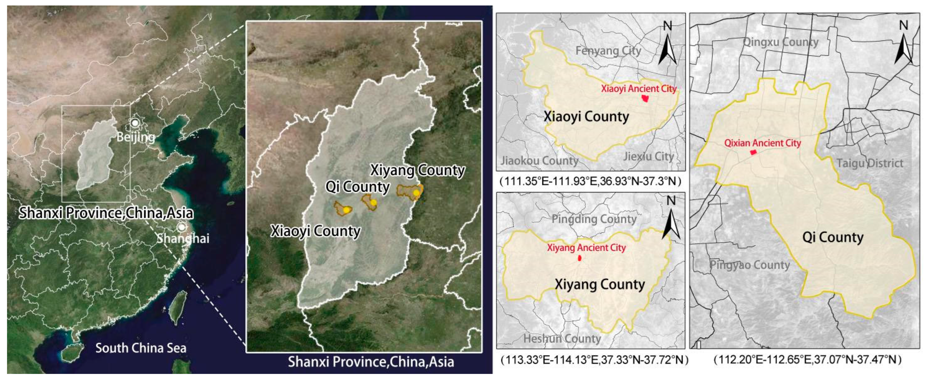
Figure 2.
Damage degree clustering classification diagram.
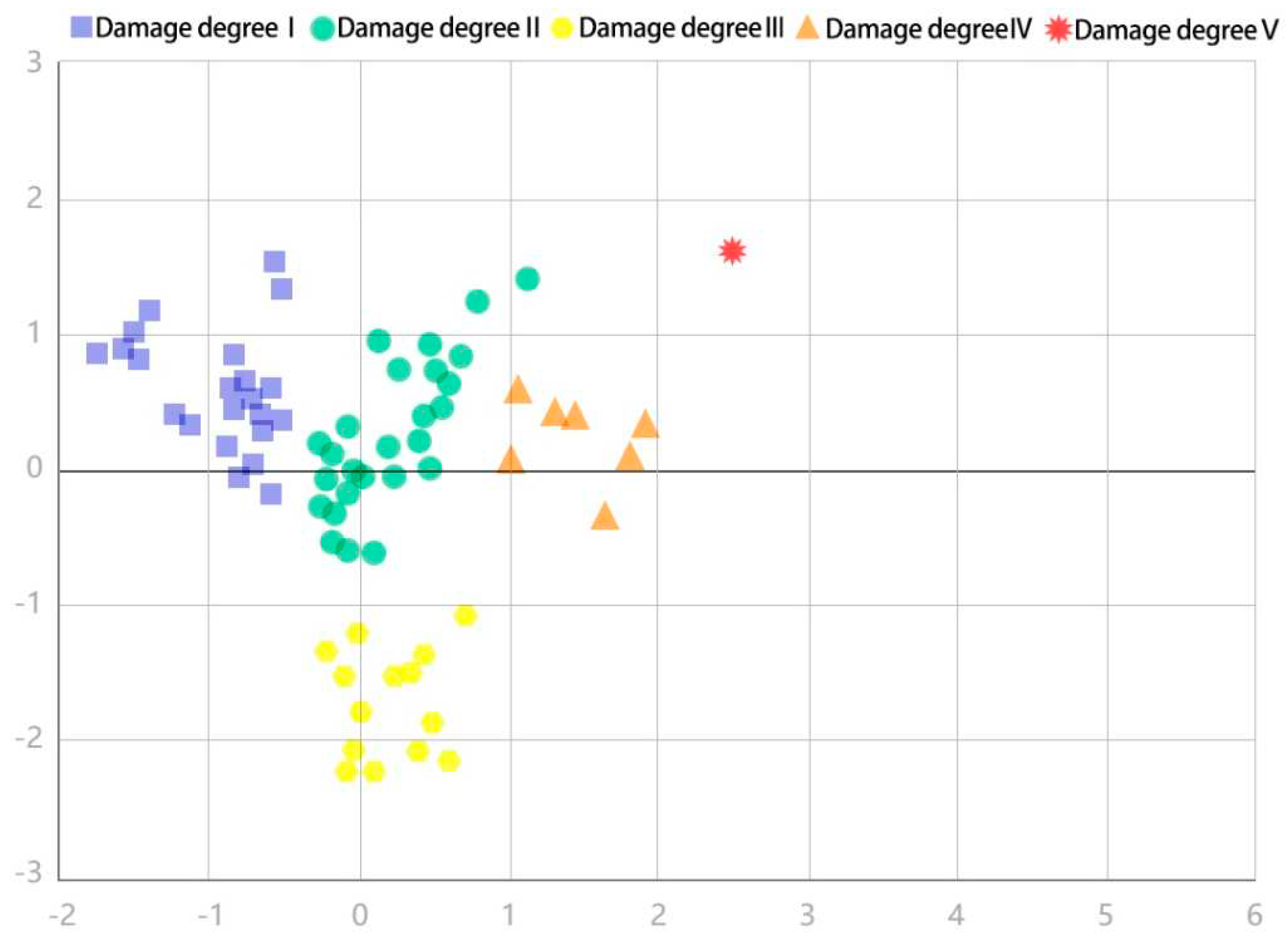
Figure 3.
Classification results of spatial damage degree of historic sites.
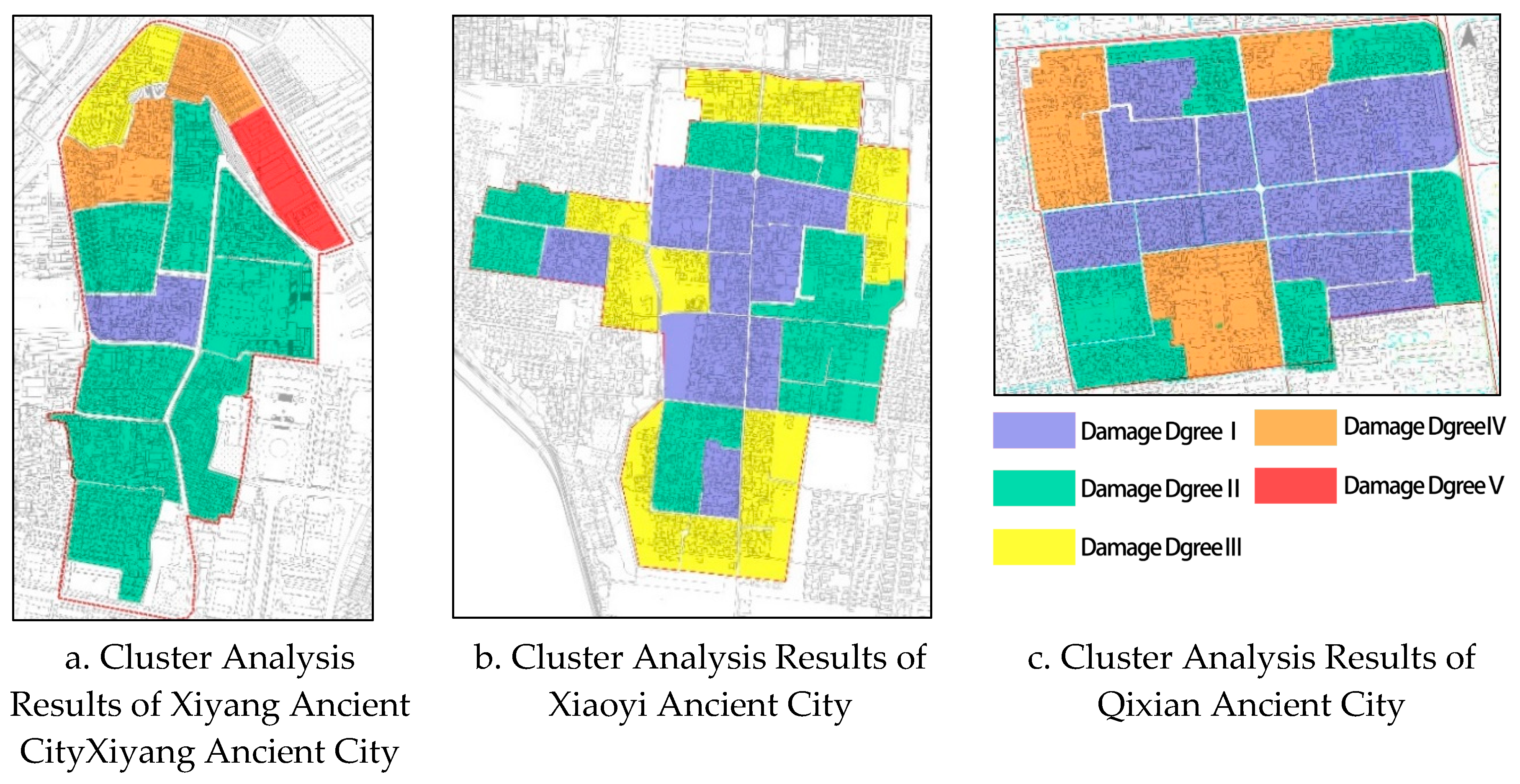
Figure 4.
Building fabric damage analysis diagram.
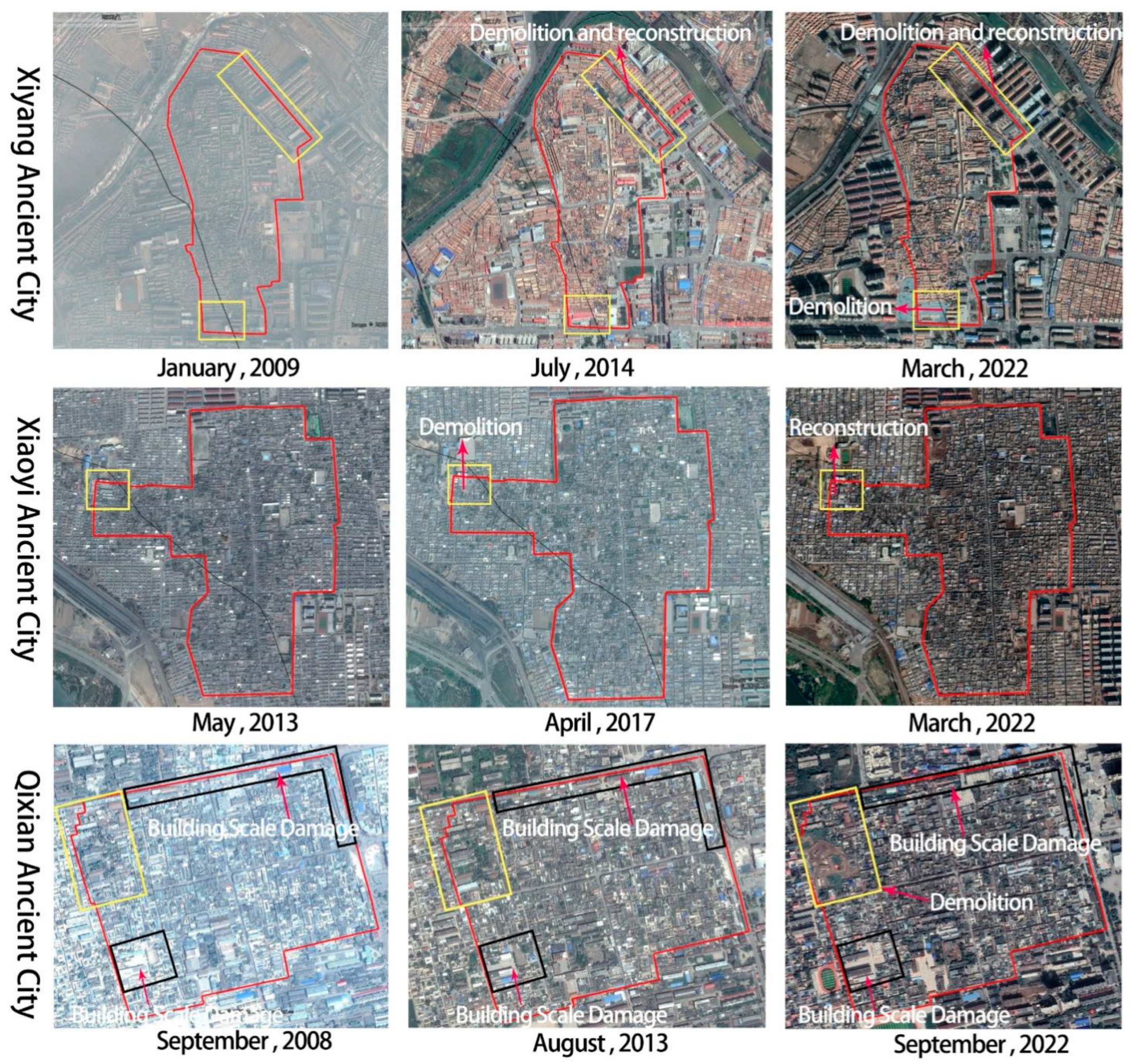
Table 1.
Data sources.
| Data Name | Data type | Data sources |
|---|---|---|
| Google Satellite Maps | Tif | Google Earth |
| Osm Building Outline Data | Osm | https://www.openstreetmap.org/ |
| Osm Road Data | Osm | https://www.openstreetmap.org/ |
| Baidu Streetscape Map | Map | https://map.baidu.com/ |
| CAD topographic map | Dwg | Local Housing and Urban-Rural Development Bureau |
| Third National Land Survey Data | shapefile | Local Housing and Urban-Rural Development Bureau |
| Aerial view of the site | Jpg | On-site research (UAV) |
Table 2.
Combined weight result.
| Index name | Delphi method | CRITIC | Multiplication synthesis |
|---|---|---|---|
| Building roof damage degree | 0.064 | 0.089 | 0.050 |
| Building feature damage degree | 0.205 | 0.170 | 0.308 |
| Building function change rate | 0.048 | 0.021 | 0.009 |
| Building dimension contradiction rate | 0.072 | 0.029 | 0.018 |
| Building structural damage degree | 0.062 | 0.028 | 0.016 |
| Damage degree of courtyard form | 0.119 | 0.211 | 0.222 |
| Street scale damage degree | 0.050 | 0.055 | 0.024 |
| Street coordination | 0.108 | 0.194 | 0.186 |
| Street continuity | 0.073 | 0.022 | 0.014 |
| Enclosing boundary survivability | 0.091 | 0.137 | 0.111 |
| Fabric evolution degree | 0.108 | 0.044 | 0.042 |
Table 3.
KNN accuracy testing results.
| Accuracy rate | Recall rate | Precision rate | F1 | |
|---|---|---|---|---|
| Training set | 0.939 | 0.939 | 0.925 | 0.93 |
| Testing set | 0.81 | 0.81 | 0.695 | 0.738 |
Note: Accuracy is the proportion of the predicted correct samples in the total samples; The recall rate is the proportion of predicted positive samples in the results of actual positive samples; The accuracy rate is the proportion of predicted positive samples that are positive samples; F1 is the harmonic average of accuracy rate and recall rate.
Table 4.
Regression coefficient table of influencing factors of spatial damage degree of historic sites.
Table 4.
Regression coefficient table of influencing factors of spatial damage degree of historic sites.
| Variable class | Independent variable | Standardization coefficient | significance | VIF |
|---|---|---|---|---|
| Building component | Building roof X1 | 0.114 | 0.296 | 3.595 |
| Building structure X2 | 0.222 | 0.331 | 15.696 | |
| Feature and form | Building feature X3 | -0.334 | 0.048 | 8.399 |
| Courtyard form X4 | -0.076 | 0.543 | 4.750 | |
| Street coordination X5 | -0.378 | 0.001 | 3.782 | |
| Building land use | Building dimension X6 | -0.028 | 0.903 | 16.624 |
| Building functions X7 | -0.097 | 0.286 | 2.492 | |
| Enclosing boundary survivability X8 | 0.728 | 0.000 | 1.443 | |
| Building fabric | Fabric evolution X9 | -0.093 | 0.278 | 2.235 |
| Street scale X10 | 0.028 | 0.684 | 1.443 | |
| Street continuity X11 | 0.144 | 0.181 | 3.469 |
Note: VIF (variance inflation factor) is used to measure the covariance of the independent variable. The larger the value, the more serious the covariance is. The standardized coefficient is the coefficient obtained after standardizing the data.
Disclaimer/Publisher’s Note: The statements, opinions and data contained in all publications are solely those of the individual author(s) and contributor(s) and not of MDPI and/or the editor(s). MDPI and/or the editor(s) disclaim responsibility for any injury to people or property resulting from any ideas, methods, instructions or products referred to in the content. |
© 2023 by the authors. Licensee MDPI, Basel, Switzerland. This article is an open access article distributed under the terms and conditions of the Creative Commons Attribution (CC BY) license (http://creativecommons.org/licenses/by/4.0/).
Copyright: This open access article is published under a Creative Commons CC BY 4.0 license, which permit the free download, distribution, and reuse, provided that the author and preprint are cited in any reuse.


