
Submitted:
24 September 2025
Posted:
25 September 2025
You are already at the latest version
Abstract
Urban heritage, when enhanced by digital technologies, can become a living laboratory. This study explores the Art Nouveau Path, a mobile augmented reality game implemented in Aveiro, Portugal, as part of the EduCITY Digital Teaching and Learning Ecosystem. Designed as a circular pathway of eight georeferenced Points of Interest, it integrates narrative cartography, multimodal media, and sustainability competences framed by GreenComp. A design-based research approach guided the study, combining four interconnected datasets: a game’s structured curriculum review by three subject specialists (T1-R), gameplay logs from 118 student groups (4,248 responses), post-game reflections from 439 students (S2-POST), and in-field observations from 24 teachers (T2-OBS). Descriptive statistics and thematic coding were triangulated to examine attention to architectural details, the mediational role of Augmented Reality (AR), spatial trajectories, and reflections about sustainability. Results present overall accuracy (85.33%), with particularly strong performance on video items (93.64%), stable outcomes on AR tasks (85.52%), and lower accuracy in denser urban contexts. Qualitative data highlight AR as a catalyst for perceiving hidden features, collaboration, and connecting heritage with sustainability. The study concludes that location-based AR games can generate semantically enriched geoinformation. They also act as cartographic interfaces that embed narrative and competence-oriented learning into urban heritage contexts.
Keywords:
geoinformation
; location-based services
; augmented reality
; trajectory analysis
; spatial storytelling
; urban heritage
; smart cities
; sustainability competences
1. Introduction
Urban heritage today is understood not only as cultural memory but also as a dynamic layer of smart cities, functioning as a living dataset that informs planning, education, and civic engagement [1]. This perspective has gained prominence in international frameworks such as the Sustainable Development Goals (SDGs), where Target 11.4 of Goal 11 [2] highlights the safeguarding of cultural and natural heritage as a pillar of sustainable urban development [3].
At the technological level, advances in Geographic Information Systems (GIS), Building Information Modeling (BIM), and Location-Based Services (LBS) have expanded the capacity to represent, analyze, and communicate urban environments [4]. More recently, Spatial Data Science approaches have refined methods for interpreting movement, combining statistical and computational techniques with geoinformation workflows [5,6]. In parallel, Augmented Reality (AR) and Extended Reality (XR) have transformed geovisualization, enabling digital overlays that situate interpretation and interaction directly in the urban fabric [7]–[9].
However, significant gaps can be identified. Analyses of trajectories still rely predominantly on Global Positioning System (GPS) traces or sensor data that, while precise, are often noisy and lack interpretative depth [10]. Efforts to enrich mobility data semantically have shown promise, particularly in cultural contexts where meaning is inseparable from space [11]. At the same time, research on narrative cartography has underlined how mapping itself can become a medium for storytelling and cultural interpretation [12,13]. Even so, the integration of semantics, narrative, and trajectory analysis within AR-based cartography remains underdeveloped. Recent proposals for semantic logging of user interactions in cultural spaces suggest a possible way forward, but their application in heritage and education contexts remains limited [14].
Mobile Augmented Reality Games (MARGs) offer a promising framework to bridge these domains. Their design is grounded in fixed trajectories, which constitute deliberate cartographic decisions and allow comparability across groups. Through multimodal overlays, they transform static maps into dynamic interfaces, embedding meaning and narrative into place. When enriched semantically, Points of Interest (PIs) can be aligned with competence-based frameworks such as GreenComp, the European sustainability competence framework [15]. This alignment connects cultural heritage to global agendas like SDG 11 and SDG 4.7 and has been noted as an underexplored dimension in recent reviews of AR in heritage communication and education [16,17].
This study aims to explore the identified gaps through the Art Nouveau Path, a MARG implemented in Aveiro, Portugal. The MARG establishes a path around eight georeferenced PIs in the city of Aveiro’s Art Nouveau old neighborhood, combining multimodal media, as old photographs, AR, videos, audio, together with a narrative storytelling, aimed to create a layered geoinformation environment. The Art Nouveau Path is anchored in the EduCITY Digital Teaching and Learning Ecosystem (DTLE) (https://educity.web.ua.pt/) (accessed on 14 September 2025). As an educational product, this MARG is played on the EduCITY app (version 1.3).
Its implementation with students originated several datasets, including gameplay logs from one hundred and twenty-three students’ groups, qualitative answers from 439 students’ follow-up questionnaire (S2-POST), twenty-four in-field teacher’s observations (T2-OBS), and curricular validation feedback from three teachers (T1-R). The remaining datasets were already present in previous works [18,19].
By considering the Art Nouveau Path as an urban laboratory, the study examines how location-based AR games can produce interpretable geoinformation while operating as cartographic interfaces that enhance the semantic and narrative depth of heritage landscapes works [18,19].
Accordingly, the study is guided by two research questions (RQ): RQ1. ‘How can location-based AR games contribute to the production and analysis of geoinformation in urban heritage contexts?’, and RQ2. ‘In what ways can AR function as a cartographic interface that enriches spatial storytelling and semantic representation of cultural heritage?’.
This work is structured in six sections. Following the Introduction, Section 2 presents a thematic literature review organized into five pillars: location-based services and trajectory analysis; augmented reality and cartographic geovisualization; semantic frameworks and narrative cartography; and urban informatics and smart heritage. Section 3 details the methodological design, the study context, and the procedures for participants, data collection, and analysis. Section 4 reports the findings from the implementation of the Art Nouveau Path, followed in Section 5 by a discussion that cross-references these results with the research questions and the thematic review. Finally, Section 6 concludes by summarizing the main findings, outlining their implications for the integration of GIS, BIM, knowledge graphs, and GeoAI in future smart heritage initiatives, and presenting the study’s limitations alongside paths for future research.
2. Related work
Given the interdisciplinary scope of this study, spanning LBS, AR, trajectory analysis, semantic frameworks, and smart heritage, it was adopted a narrative thematic literature review [20]–[22]. This approach is particularly suited to synthesizing heterogeneous evidence across adjacent research domains, provided that selection and synthesis procedures are transparent and rigorous.
Searches were conducted in Scopus and Web of Science during July - August 2025, covering the period 1997–2025. Keyword families reflected the four target domains and were combined with Boolean operators to capture interdisciplinary intersections: location-based services AND heritage AND education; augmented reality AND cultural heritage AND learning; semantic trajectory AND cultural heritage; narrative cartography AND mapping; smart heritage AND sustainability; and, GreenComp AND education. This review was also informed by previous literature research.The database search retrieved 64 records. Following the screening of abstracts and the removal of duplicates, 24 items were retained for full-text review. The usage of the inclusion criteria (peer-reviewed, English-language, explicit relevance to at least one of the four domains, and connection to education, cartography, mapping, location-based, sustainability, or heritage) resulted in the final peer-reviewed corpus comprising 43 articles. To ensure conceptual breadth, the articles were complemented with six policy and institutional frameworks, nine books and monographs, and three prior research outputs by the authors. Non-peer-reviewed sources were not captured via database searches but were selected from previous research and authoritative references in the context of Aveiro, heritage, geoinformation, and sustainability. Exclusion criteria were systematically applied. Most of the excluded works were of a tourism- or marketing-oriented nature, with a focus on virtual reality (VR) rather than AR or addressed museum learning without geoinformation or trajectory. The final corpus thus comprised 61 sources, which were structured into four categories (see Appendix A).
Analysis followed a hybrid thematic strategy, combining deductive coding guided by the five domains with inductive exploration of emergent patterns [23]. This ensured both conceptual coherence and openness to novel intersections, providing the foundation for the four thematic subsections that follow.
2.1. Geoinformation and Location-Based Services
Geographic Information Science (GIScience) and location-based services (LBS) provide the geotechnological foundation for location-aware educational applications. GIScience has evolved beyond static mapping to incorporate dynamic spatial processes and user-centered perspectives [4]. This evolution reflects a shift from viewing maps purely as representations of form toward understanding the processes and interactions they signify in the real world [4]. Modern mobile devices equipped with GPS and sensors enabling LBS, applications that deliver content or functionality tailored to a user’s geographic location in real-time. LBS have proliferated across smart cities, allowing citizens to serve as “sensors” contributing georeferenced information and experiences [24]. In the education context, this means the city itself can become an interactive learning environment. By marrying geospatial data with pedagogical narratives, location-based educational games turn urban landscapes into “smart” learning spaces where contextually relevant content enhances engagement. For example, smartphone-guided heritage tours exemplify how LBS can foster dynamic tourism experiences, linking cultural information to specific sites and moments [25,26]. Such location-driven experiences leverage real-world exploration, aligning with the concept of ‘lifelong and lifewide learning’ [27,28] in a smart city, learning that occurs across one’s lifespan and in diverse informal settings [29]. The rise of urban informatics and smart city initiatives further highlights the potential of geoinformation technologies to personalize and enrich user experiences in situ. Within this project’s scope, geoinformation and LBS enable the adaptive delivery of content based on where learners are, situating educational challenges and narratives in the physical Art Nouveau heritage sites of the city of Aveiro. This geolocation-responsive design is fundamental to engaging users in a pervasive learning experience that connects virtual or augmented information to real-world context [18]. Figure 1 presents the MARG in-app game.
Beyond basic mapping, LBS in educational games rely on robust geospatial data infrastructures and real-time positioning. Accuracy and interactivity in these systems draw on advances in spatial data handling and user interface design. Research in spatial data science underlines the importance of integrating heterogeneous geographic datasets, like maps, sensor readings, user-contributed data, to support sustainable mobility and location-aware decision making [5]. These advances ensure that location-based apps can provide timely, precise feedback to users navigating in real-world settings. Moreover, the participatory aspect of LBS aligns with the trend of ‘Volunteered Geographic Information’, wherein users actively contribute location-tagged content (knowingly or unknowingly) that can enhance the collective knowledge of places [24].
In summary, the convergence of GIScience and LBS has laid the groundwork for MARGs like Art Nouveau Path, which require both the technical capacity to pinpoint users in an urban setting and the conceptual approach of treating the city as an interactive, pedagogical canvas. Geoinformation technologies not only map where learning takes place but also help shape how learning takes place by linking location to relevant information and tasks. By that, this approach can foster the development of concepts like Identity and Memory [30,31], supporting the notion of space as a common value [32].
2.2. Trajectory Analysis and Spatial Semantics
The Art Nouveau Path project involves users moving through the city, creating spatio-temporal trajectories that carry implicit information about their learning journey. Understanding and analyzing the data from this movement pattern is crucial for evaluating engagement and guiding users through meaningful paths. Although the route on the Art Nouveau Path is the same for each user, trajectory analysis techniques from GIScience and urban computing provide methods to collect, interpret, and visualize data (game logs) from users [10]. Such techniques include recording GPS tracks or check-in sequences (like this study’s case) and then applying computational methods to identify significant patterns or differences in how individuals or groups navigate the common space. For instance, sequence alignment methods have been adapted from bioinformatics to compare human activity paths, revealing common paths or visitation orders among participants [33]. Visual analytics of movement data offers further means to uncover trends, as large volumes of tracking data can be interactively explored for patterns like frequently visited sites, time spent, or preferred transitions [34]. By leveraging these approaches, this project can assess which Art Nouveau landmarks attract more attention (by answering accuracy) or which parts of the game might cause delay or confusion (observed by teachers at T2-OBS), thereby informing iterative design improvements. Recent data-driven movement analysis frameworks emphasize combining quantitative trajectory metrics with qualitative insights, acknowledging that human mobility data can be mined for actionable knowledge about behavior in space [6]. In an educational urban game, such analysis might reveal learning “hotspots”, locations where users show high engagement or identify if certain narrative segments encourage users to take exploratory detours versus directed paths.
A distinctive aspect of trajectory analysis in cultural heritage education is the incorporation of spatial semantics, the meanings and contextual information associated with locations and paths. Rather than treating a user’s path as a mere sequence of coordinates, semantic trajectory analytics enrich these paths with information about the places and events encountered [11]. In practice, this could involve linking each PI on a user’s journey to a knowledge base or category, like identifying a site as an Art Nouveau Museum, a private house, or an urban garden, and what thematic history it represents.
By interpreting movement data with semantic tags, it becomes possible to understand not just the users’ paths, but also why that matter. Angelis et al. [11] demonstrate that in cultural spaces, combining trajectory data with semantic information, as exhibit themes or historical context, enables more powerful analyses and even recommender systems. For example, in the Art Nouveau Path, the suggestion of points of interest and path was induced by previous MARG validation [19], combining curricular knowledge with sustainability competences development [18,19]. This semantic enrichment of spatial data often relies on ontologies and linked data. In our context, aligning with standards such as the International Committee for Documentation of the International Council of Museums Conceptual Reference Model (CIDOC-CRM) [35] helps ensure that heritage locations, events, and story elements can be represented in an interoperable way. While the present study does not formally implement the model, its categories can be mapped conceptually to CIDOC-CRM classes and properties, which would enable connecting user trajectories to broader cultural knowledge graphs.
Overall, analysis combined with spatial semantics and storytelling narrative provides a dual quantitative-qualitative lens: it reflects movement and engagement patterns while also collecting data, via gaming logs, interpreting the cultural meaning of path. This is central for this study, that is on the intersection of geography, education, sustainability development, and heritage, enabling a deeper understanding of how users experience urban space and future data-driven refinement of the MARG.
2.3. Augmented Reality as a Cartographic Interface
AR offers a powerful medium to overlay digital information onto the physical world, effectively acting as a live cartographic interface for users. In an AR-based heritage game, the city map is no longer confined to paper or screen, it is experienced directly through the camera view, with virtual elements anchored to real locations. Figure 2 presents the interaction between real-world and AR content.
AR’s educational benefits are well documented, particularly its ability to provide immersive, context-rich learning experiences [36]. By overlaying historical images, 3D models, or interactive clues onto buildings and streets, AR facilitates learners to visualize spatial relationships and temporal layers of information that would be hard to transmit otherwise.
Studies regarding STE(A)M education have stated that AR can increase student motivation and understanding by contextualizing learning in authentic environments [37,38]. This aligns with the goals of Art Nouveau Path, which uses AR to let participants see architectural details or past scenes, by videos or photographs, in situ, thereby deepening their appreciation of Art Nouveau heritage through direct interaction. Crucially, to deliver such location-based AR content effectively, the EduCITY app requires an intuitive cartographic interface (Figure 3).
In practice, this means combining in-site visual PIs, mapping information, GPS navigation cues, and AR visuals in a whole user experience. The map (digital or mental) remains the bridge between the user’s physical movement and the digital content: it guides users to points of interest and frames the AR usage narrative in-context. Recent design research on mobile AR in cultural heritage underscores the importance of clear interaction patterns for storytelling, such as visual cues to guide users where to look or how to trigger content [39,40]. In essence, the AR platform must balance the richness of on-screen overlays with the need for spatial orientation, functioning as a dynamic map that not only shows where to go but also unlocks layers of narrative at each location.
Over the last decade, AR applications have become prevalent in cultural heritage, serving as both interpretative tools and entertainment media. Comprehensive reviews highlight a wide range of AR use cases in heritage, from virtual museum guides to on-site reconstructions of historical scenes [7,39,40]. These studies show that AR is particularly effective in engaging the public with heritage content by providing interactive experiences that can adapt to different ages and learning styles. Within this spectrum, location-based AR games form a distinct subset that merges AR with geolocation, examples include city exploration games and heritage treasure hunts. Empirical works by [16,17] describes location-based AR applications for historic districts, demonstrating how AR can facilitate both the communication of cultural information and active learning through exploration. Likewise, an AR serious game developed for cultural tourism was found to enhance 21st-century skills such as problem-solving and collaboration, indicating the educational potential of AR gaming in real urban settings [41]. These findings reinforce the idea that AR, when designed with pedagogical intent, can transcend novelty and serve as a cartographic interface that guides and teaches simultaneously. In the Art Nouveau Path, AR elements overlaid on building facades or are triggered by monuments shapes or typical Portuguese pavement details. Also, AR content is tightly interwoven with the map-based in-app gameplay. The success of such an approach depends on careful interface design: users should intuitively understand how to navigate the city, by using maps or directional cues, and when to engage with AR content.
A well-designed AR-based cartographic interface ensures that technology augments rather than distracts from the physical exploration of heritage and sightseeing. It connects the dots between locations, narrative, and user actions, essentially functioning as an interactive map that brings the past and unseen to life in the present environment.
2.4. Semantic Frameworks and Narrative Cartography
A key insight from heritage education research is that places and facts gain greater significance when they are woven into compelling narratives. Narrative cartography is the paradigm that explores the integration of storytelling with mapping, examining how maps can convey stories and how stories can be anchored in geographic space [12]. Rather than presenting historical information as isolated data points or disjointed site descriptions, narrative cartographic approaches link them along storylines that users can follow through space and time. This is particularly powerful in urban heritage contexts: a city like Aveiro can be seen as a palimpsest of cultural, artistic, and social histories, and narrative maps help uncover these layered stories. For instance, the Art Nouveau Path might be framed as a contribution to the story of a city’s transformation at the turn of the 20th century, based on Art Nouveau movement chapter itself. In fact, each building and monument represents a “chapter” in the MARG, but also Aveiro’s unique Art Nouveau narrative, from the ‘Obelisk of Freedom’, concluded in 1909 (PI 1) (Figure 4), the old ‘Ala Pharmacy’, concluded in 1915 (PI 2) (Figure 4), the ‘João Mendonça Street’ (PI3) (Figure 5), the ‘Old Agricultural Cooperative’, a former private house, belonged to Mr. Anselmo Ferreira, and concluded in 1913 (PI 4) (Figure 5), the ‘Aveiro’s City Museum’, a former private house, concluded around 1915 (PI 5) (Figure 5 and Figure 6), the ‘Art Nouveau Museum’, a former private house, the ‘Mário Belmonte Pessoa’s House’, concluded in 1909 (P1 6) (Figure 7), the ‘Old Fish Market’, concluded in 1904 (PI 7) (Figure 8) to the ‘Pensão Ferro’ (old guesthouse), concluded in 1904 (PI 8) (Figure 9).
The MARG has a circular path, and the first PI is also the last one, that in this moment becomes a technical PI. The act of mapping these chapters is itself a narrative exercise since the selection and sequencing of sites create a plot that users experience spatially. Previous researchers have noted that maps are not neutral since they reflect the perspectives and purposes of their creators but also from its users, essentially carrying a narrative or argument within their design [42].
By embracing narrative cartography, the Art Nouveau Path MARG aims to offer participants a coherent storyline of Art Nouveau in Aveiro, valuing it and developing sustainability competences through it, rather than a random collection of facts. This approach can enhance user engagement and memory, as humans are cognitively wired to remember stories better than lists of information. Also, the sense of belonging is essential to activate learning [43]. Caquard [13] emphasizes the growing interest in the relationship between maps and narratives, suggesting that spatial narratives allow for multi-dimensional understanding – one that combines geography with chronology, emotion, and meaning. In practice, implementing narrative cartography in a mobile app means carefully designing the sequence of tasks and information to follow a narrative arc, perhaps with characters or thematic quests guiding the user.
Implementing narrative-driven experiences in a digital heritage project also calls for robust semantic frameworks to manage content and context. As the user moves through the narrative, the system must keep track of which story elements have been seen, how they relate to each other, and how they connect to real-world heritage objects. Semantic frameworks, often in the form of ontologies or knowledge graphs, provide a structured way to represent this information. In the cultural heritage sector, the CIDOC-CRM has emerged as a prominent ontology for capturing the relationships between cultural artifacts, historical events, people, and places [35]. In the context of this MARG, the design principles are conceptually compatible with such a semantic standard, ensuring that each Art Nouveau landmark can be treated not merely as a GPS point but as an entity with attributes and relations that could be mapped to CRM classes and properties. This resonate in the MARG as information regarding the architectural style, dates of construction, curiosities, and links to other entities, like Réseau Art Nouveau Network (RANN) (https://www.artnouveau-net.eu/, accessed on 14 September 2025). The MARG’s narrative also presents the main local artists, like architects Franciso da Silva Rocha (1864-1957) (Figure 10), Ernesto Korrodi (1877-1944) and Jaime Inácio dos Santos (1874-1942), or the tile craftsmen and painters, like José de Pinho (1874-1964) and Lícinio Pinto (1882-1951), among many others.
This semantic enrichment of the MARG’s content enables a deeper interconnected narrative. For example, considering by that two PIs in the Art Nouveau Path share one or two historical figure, the MARG’s design highlights that connection as part of the local and common past, thereby reinforcing belonging [43,44]and learning. Additionally, a well-defined semantic framework allows the project to be extensible and interoperable since new content can be added in a consistent way, and data can potentially be shared with digital libraries or museum databases.
Beyond CIDOC-CRM, broader semantic web technologies may be added in future work. By adding these, links may occur from the MARG’s own narrative to external knowledge. For instance, fetching related images or biographies from Portuguese or international artistical repositories or websites like the RANN one.
In summary, narrative cartography provides the conceptual model to fuse place and history, while semantic frameworks provide the data model to ensure that fusion is rich, consistent, and computable. Together, they enable the Art Nouveau Path to deliver an experience that is not only engaging on the surface but also built on a rigorous representation of cultural knowledge, paving the way for meaningful storytelling supported by data.
2.5. Smart Heritage and Sustainability Competences
Beyond the specific realms of geotechnology, AR, and storytelling, the Art Nouveau Path is situated at the intersection of smart cities, cultural heritage, and education for sustainable development. The term smart heritage encapsulates the idea of leveraging smart city technologies, such as ubiquitous connectivity, data analytics, and interactive media, to enhance the management and dissemination of cultural heritage [25,45].
In a smart city, infrastructure and citizens are increasingly connected, creating opportunities to engage the public with heritage in dynamic ways. Urban heritage thus becomes not just a static legacy to be preserved, but an active resource in urban innovation and community identity. Recent research emphasizes integrating cultural heritage into smart city development through placemaking, arguing that technology-enhanced heritage experiences can strengthen local identity and social sustainability in cities [46]. By embedding the Art Nouveau heritage of Aveiro into a gamified app, the Art Nouveau Path illustrates this integration: the city’s unique art and architecture are used as anchors for a digital experience that is primarily educational while also offering potential value for cultural tourism, thereby contributing to smart heritage as a field distinct from but connected to smart education and smart tourism.
Importantly, global policy frameworks have started to recognize cultural heritage as a driver for sustainable development. The United Nations’ 2030 Agenda [47] and the New Urban Agenda [48] or the European Cultural Heritage Skills Alliance project [49] encourage cities to leverage heritage to achieve Sustainable Development Goals (SDGs) [2] related to inclusive and sustainable communities, ground on education, and aiming economic vitality [1,50]. Heritage-led development can foster a sense of place and continuity, contribute to social cohesion, and even drive sustainable urban regeneration. In line with these ideas, built heritage conservation and education are seen as part of the broader sustainability discourse [3]. The Art Nouveau Path design and narrative aligns with these global perspectives by using digital tools to make heritage accessible and engaging, thereby indirectly contributing to targets like quality education (SDG4), sustainable cities (SDG11), and partnerships for preserving cultural heritage (SDG17).
A distinguishing goal of this MARG is to promote sustainability competences among its participants. Education for Sustainable Development (ESD) has increasingly focused on not just transferring knowledge about sustainability, but cultivating competencies – combinations of skills, values, and attitudes – that empower individuals to act for sustainable futures. The European Commission’s GreenComp framework organizes these sustainability competences, identifying key areas such as critical thinking about sustainability, promoting fairness, valuing nature, and envisioning sustainable futures [15]. By engaging with the Art Nouveau heritage through this MARG, learners are prompted to reflect on themes like cultural preservation (why saving heritage is important for future generations), social inclusion (the artist’s names and old known photographs behind the buildings or monuments architecture), and environmental context (since Aveiro’s Art Nouveau inspiration relates to local flora and fauna but also the use of local materials, like adobe or local-made tiles (Figure 11).
These reflections link into GreenComp competences. As example, recognizing the value of cultural and natural heritage aligns with Valuing Sustainability, and collaborating in gameplay can relate to Participatory, and fairness-oriented competences. Recent studies have started to explore the role of mobile AR games in fostering such competencies in urban settings. Marques et al. [51] found that MARGs designed for a smart learning city environment can indeed raise students’ awareness of sustainability issues and improve their understanding of sustainability concepts through active participation. Accordingly, in the Art Nouveau Path, this means that as players answer quizzes and uncover narratives, they are not only learning about Art Nouveau. Players are also practicing systems thinking (seeing how art, history, and urban life interconnect), strategic thinking (planning decisions through the MARG’s narrative), and collaborative and values reasoning (by working with others, appreciating heritage, and by learning about the need of preserving and valuing it). The MARG’s design was informed and validated by these educational goals [18,19], ensuring that the enjoyment of a walking tour around ‘known space’ [43,52] relates to moments of personal and peered reflection or discussion that are grounded on sustainability themes.
3. Materials and Methods
3.1. Research Design and Methodological Orientation
This study adopts an exploratory case study within a design-based research (DBR) approach [53,54], integrating design, enactment, analysis, and iterative refinement to align pedagogical goals, technological affordances, and curricular value [53,54]. The Art Nouveau Path was designed and implemented as part of the EduCITY Digital Teaching and Learning Ecosystem (DTLE) (https://educity.web.ua.pt/) (accessed on 14 September 2025), a research and development project based on the University of Aveiro (Portugal) that researches how MARGs can be embedded into urban educational contexts to foster Education for Sustainable Development (ESD). Within this framework, the Art Nouveau Path functions as a place-based, competence-oriented intervention, transforming Aveiro’s city Art Nouveau heritage into both a ‘living classroom’ and an ‘experiential laboratory’ for sustainability competence development.
The broader research design included a quasi-longitudinal structure with several instruments applied in different phases. There were applied three different instruments to students (S1-PRE, S2-POST, S3-FU). These instruments were applied in three different phases: prior the MARG activity (S1-PRE, to gather baseline data); immediately after the MARG activity (S2-POST, to collect immediate data); and the S3-FU, aimed to understand medium-term MARG’s effect.
To collect data from teachers, it was developed the same approach, but in just two phases. The first phase aimed to validate the MARG. This validation occurred with thirty-three in-service teachers: thirty by participating in a themed workshop about the MARG, and three performing a MARG’s curricular review. All the suggestions of these teachers were considered for the last MARG’s version. This process is in-depth described in previous authors’ works [18,19].
Besides these, the gaming logs are also essential on the forthcoming analysis. For this study’s purpose, though, analysis is restricted to three qualitative sources of evidence: (i) a structured curriculum review conducted by teachers (T1-R), (ii) students’ open-ended post-game reflections (S2-POST), and (iii) the in-field observations, reported by accompanying teachers (T2-OBS). These are triangulated with the gaming logs.
Together, these data streams provide complementary perspectives on curricular alignment, student engagement, and the situated affordances of AR-mediated learning in an urban heritage environment. This methodological orientation follows established standards in serious games and ESD research, emphasizing ecological validity, competence orientation, and active stakeholder involvement [2,15,55,56].
3.2. Study Context and Intervention
This study was conducted in Aveiro, Portugal, where the city’s Art Nouveau district was mobilized as a ‘living laboratory’ for narrative, georeferenced learning. Aveiro’s Art Nouveau fabric, documented in urban-historical analyses of the city’s spatial evolution [57] offers a compact and walkable environment in which facades, ornaments, and streetscapes serve as anchors for in-situ analysis-product [18,19].
At the turn of the twentieth century, Art Nouveau blended international aesthetics with local identities and materials, making it particularly suitable for exploring sustainability-related themes such as nature motifs inspired by flora and fauna, craft traditions, water, and urban transformation [58,59].
The Art Nouveau Path operationalizes this built heritage as a geoinformation experience: a micro-itinerary of eight georeferenced PIs that combine map-based navigation with on-site AR exploration. Each PI integrates archival photographs, narrative prompts, and semantic tags, linking built heritage to sustainability competences through contextualized storytelling. Conceptually, the in-app city map provides an overview cartography, while the AR camera view functions as a situated layer that “remaps” architectural details directly onto the streetscape [8,18,19]. This conceptual design enhances wayfinding and spatial awareness while enabling stories to unfold across sites rather than being confined to a single landmark [16,17].
The Art Nouveau Path was developed between 2023 and 2024 as the research outcome of a doctoral project. Its design combined fieldwork on Aveiro’s built heritage with the creation of digital assets, including 3D models, AR features triggered by architectural details, and integrated multimedia resources. Across the eight PIs, participants engaged with 36 quiz-type questions, each structured around an introductory cue, a four-option multiple-choice task, and immediate feedback that clarified correctness and provided rationale. Historical photographs, contextualized video clips, and one audio recording were embedded as triggers to stimulate curiosity, spatial awareness, and critical reflection. Implemented via the EduCITY mobile app (version 1.3). The validation with teachers (T1-VAL) and implementation with students happened with the EduCITY’s Android smartphones, ensuring standardization across all the participant groups while maintaining ecological fidelity in authentic urban conditions.
3.3. Participants
Four groups contributed to this study. The first group comprises thirty in-service teachers (seventeen female, thirteen male) who participated in the validation workshop (T1-VAL). Simultaneously, the second group comprised three teachers with disciplinary expertise in History, Natural Sciences, and Arts/Citizenship conducted the MARG’s structured curricular review (T1-R). Their involvement ensured feedback on curricular and pedagogical alignment, usability, and the integration of sustainability competences.
The third group involved 439 students who participated in the implementation of the Art Nouveau Path MARG during regular school hours. Recruitment was carried out through the ‘Municipal Educational Action Program of Aveiro’ (PAEMA, 2024–2025 edition), resulting in a convenience sample. Students, aged 13-18, were distributed across 19 classes from 6 different grades (7th: N = 19; 8th: N = 135; 9th: N = 156; 10th: N = 37; 11th: N = 20; 12th: N = 72), from urban and peri-urban schools. No data on socio-economic background and gender were collected, as the study prioritized data minimization and ecological validity. While this decision aligns with literature questioning the robustness of certain demographic effects [60], it also limits the possibility of analyzing differential patterns across groups.
While the broader project collected student data across three study phases (S1-PRE, S2-POST, and S3-FU), this paper focuses exclusively on the open-ended post-game reflections from the S2-POST instrument. Students played in groups of two to four, each group using a single EduCITY’s Android smartphone running the EduCITY app (version 1.3), which fostered collaboration and mirrored realistic device availability.
The forth group comprised the accompanying teachers (N = 24) supervised logistics and safety during the eighteen field sessions and documented their observations using the T2-OBS questionnaire, focusing on student engagement, navigation, and interaction with AR content in the real-word context.
Participation across all groups was voluntary. Informed consent was obtained from all teachers, and from students with supplementary parental or legal guardians’ authorization. No personally identifiable data were collected; all datasets are anonymized and compliant with the General Data Protection Regulation, in accordance with the ethical guidelines of the University of Aveiro.
3.4. Data Collection Instruments
The study employed four complementary instruments, each targeting a distinct group of participants and designed to capture a specific layer of evidence. When considered as a whole, these instruments provided a basis for methodological triangulation consistent with the principles of DBR [53,54]. This methodological triangulation combined perspectives from curricular review, student reflection, ecological observation, and automated traces of gameplay. Table 1 provides an overview of the instruments employed in this study, which are described in detail.

Table 1.
Overview of data collection instruments used in this study.
| Instrument (Code) | Participants (N) | Focus | Data Type | Purpose within the study |
|---|---|---|---|---|
| Teachers’ Curriculum Review (T1-R) | 3 in-service teachers | Curricular alignment, interdisciplinarity, cognitive adequacy, sustainability competences | Structured rubric with written justifications | External validation of the game’s pedagogical and curricular coherence |
| Students’ Post-Game Questionnaire (S2-POST) | 439 students | Learning outcomes, perceptions of heritage–sustainability links, AR experience | Open-ended responses (qualitative) | Capture student sense-making, affective engagement, and suggestions for improvement |
| Teachers’ Observation Protocol (T2-OBS) | 24 teachers | Student engagement, collaboration, group dynamics, AR use in situ | Likert items, checklists, narrative comments | Provide ecological evidence of learning processes under authentic conditions |
| Automated Gameplay Logs | 118 student groups | Completion, correctness, distractor choice, total session duration | App-generated, anonymised performance traces | Identify accuracy patterns, common misconceptions, and feasibility of path duration |
The MARG’s Curricular Review (T1-R) was conducted by three in-service teachers from the subject areas of History, Natural Sciences, and Arts/Citizenship. Each teacher was granted access to the comprehensive set of game materials, encompassing the narrative sequence, quiz items, AR markers, and associated multimedia resources. These teachers were invited to complete individually curricular structured rubric. The rubric guided their analysis across six key dimensions: (i) the alignment of content with curricular objectives; (ii) the potential for interdisciplinary articulation; (iii) the promotion of critical thinking; (iv) the fostering of observational and analytical skills; (v) the application of discipline-specific concepts, and (vi) the cognitive and age appropriateness of the MARG materials and narrative. Teachers were encouraged to provide a rationale for their ratings, producing evaluative judgments supported by qualitative commentary. Their contributions not only substantiated the curricular and pedagogical coherence of the Art Nouveau Path but also highlighted refinements in language, scaffolding, and sequencing. In-depth analysis of this MARG’s curricular review was focus of authors’ previous works [18,19].
The Students' Post-Game Questionnaire (S2-POST) was administered to all 439 participants immediately after gameplay. While the instrument combined scaled and dichotomous items with open-ended prompts, this study draws exclusively on the latter. The students were tasked with providing examples of their learning, completing the sentence ‘For me, sustainability is...’, and articulating novel insights concerning the Art Nouveau heritage. The participants were invited to consider the following questions: first, whether cultural heritage could serve as a pathway into sustainability; second, whether they wished to learn more about Aveiro's Art Nouveau; and third, whether they recognized competences for sustainability within the MARG. Despite the incorporation of an adapted Portuguese version of the GreenComp-based GCQuest instrument (available at: https://doi.org/10.5281/zenodo.15919738), the scope of this paper does not encompass the aforementioned scaled items. The open-ended responses are of significant value, as they elucidate the way students articulated their learning, integrated values with knowledge, and expressed affective engagement with the interplay of heritage and sustainability. This instrument was applied immediately after the MARG playing.
The Teachers' Observation instrument (T2-OBS) was completed by 24 accompanying teachers during the field sessions. This instrument combined Likert-scale statements, structured checklists, and space for narrative reflection. Teachers were invited to comment on the extent to which the game supported competence development, heightened student interest through AR, and encouraged appreciation of local heritage. Additionally, concrete observations of student behaviors were recorded, including curiosity towards architectural elements, the capacity to engage in discourse concerning sustainability matters, expressions of pride in local heritage, collaborative problem-solving, and group interactions. The instrument’s inclusion of items concerning professional impact was a notable feature. These items sought to ascertain whether the experience motivated teachers to incorporate heritage, sustainability, or AR-based strategies in their future practice. Consequently, the observations furnished an ecological perspective on the intervention's progression in authentic educational settings.
The fourth instrument comprised the Automated Gameplay Logs, which were generated by the EduCITY app (version 1.3) during each session. A total of 118 student groups, each consisting of two to four learners working with a shared smartphone, were registered for the study. The logs contained the start and end timestamps of each session and item-level data for all 36 quiz-type tasks (P1.1–P8.2) distributed across the eight PIs.
For each item, the degree of completion and the presence of correctness were documented. In instances where an incorrect response was provided, the specific distractor that was selected was also recorded by the system. This additional detail facilitates the identification of recurring misconceptions and the discernment of distractors that elicit systematic errors, thereby offering insights into cognitive challenges that extend beyond raw accuracy rates. Given that the logs are stored exclusively at the group level and contain no personal identifiers, the dataset is fully anonymized and ethically compliant.
Despite the temporal resolution limitations of the logs, which result in the inability to discern dwell times at specific PIs, the logs provide substantial evidence regarding the feasibility of the system, the variability in pacing across groups, and item-level performance patterns.
In the present study, these instruments were employed for three primary purposes: first, to summarize completion and accuracy distributions; second, to identify outliers in session duration; and third, to cross-check the ecological evidence recorded by the accompanying teachers (T2-OBS).
When considered as a whole, these four instruments provided a consistent and multifaceted methodological framework. Each perspective informed the Art Nouveau Path from a distinct vantage point, and their integration enabled a more comprehensive understanding of the MARG's functionality and goals. This functionality encompasses its role as a pedagogical resource grounded in curricular demands and as a situated, AR-mediated learning experience embedded within the spatial and cultural fabric of the city of Aveiro.
3.5. Field Procedures and Data Capture
The field sessions were conducted between February and May 2025, following the Teachers’ validation (T1-VAL) and Curricular Review (T1-R) undertaken in December 2024.
Each activity began with a short safety and interface briefing, an adjustment suggested during the T1-VAL workshop, after which student groups initiated the linear and circular path crossing the eight PIs in Aveiro’s Art Nouveau old neighborhood. The path was supported by the in-app map, combined by in-situ and in-app informative markers (like photographs and narrative guide) and GPS cues. At each site, multimodal content, including AR overlays, introduced the location, followed by quiz-type challenges linked to architectural and surrounding details. This multimodal progression through the city fostered embodied engagement and contextual learning, which have been highlighted as key affordances of mobile AR in heritage education [16,17,37,41].
Each session concluded with a short debrief. Students then completed the S2-POST questionnaire, while accompanying teachers finalized their T2-OBS questionnaires. Project smartphones were collected, and the automated gameplay logs were subsequently uploaded at the University of Aveiro to a secure server, as the devices had no SIM cards and therefore no direct internet access during the sessions. The logs contained the calendar date of each session, start and end times, and item-level outcomes, including correctness and, in cases of error, the specific distractor selected. All datasets were anonymized at the group level, with no possibility of individual or group identification.
3.6. Data Analysis Strategy
The analysis followed a mixed-methods approach [61,62], combining descriptive statistics, thematic coding, and triangulation into an explanatory synthesis [23]. The gameplay logs were treated quantitatively at the group level (N = 118), with descriptive measures calculated on Excel, for session duration, completion, and accuracy, as well as the distribution of distractor choices in cases of incorrect responses. These indicators were used to characterize overall performance patterns and to highlight items or PIs where difficulties tended to concentrate.
The qualitative materials, teacher reflections (T1-R), and observational questionnaire (T2-OBS), and students’ open-ended responses (S2-POST), were examined through thematic analysis by the authors and an EduCITY team member. Deductive categories derived from previous works [18,19,51], and from the GreenComp framework [15], while inductive coding enabled the identification of emergent dynamics. This process converged into four cross-cutting categories that guided the interpretation of results: (i) attention to the built heritage and architectural details, (ii) the role of AR as a catalyst for interest, (iii) spatial trajectories and urban mobility, and (iv) critical reflection on sustainability and the city. The teachers’ curriculum review (T1-R) is treated as an external validation axis that triangulates with these four categories, since it has been previously analyzed and published.
Coding reliability was strengthened through iterative double-coding and peer debriefing, ensuring that interpretations remained grounded in the data.
Finally, quantitative and qualitative findings were integrated into analytic matrices linking GreenComp dimensions to the different datasets. Outliers and apparent inconsistencies were approached as instructive for design refinement rather than as anomalies, reflecting the DBR principle of aligning design, enactment, analysis, and iterative redesign [53,54]. This integrative strategy provided the foundation for the explanatory synthesis reported in the findings.
4. Findings from the Art Nouveau Path Implementation
4.1. Overview of Data Sources
The findings draw on complementary datasets: automated gameplay logs (N = 118 groups), students’ post-game open-ended reflections (S2-POST, N = 439), observation protocols from accompanying teachers (T2-OBS, N = 24), and the structured curriculum review by three in-service teachers (T1-R). Categories of analysis were developed collaboratively by the two authors and one EduCITY researcher, through thematic analysis, combining GreenComp-informed deductive coding with inductive coding. Four cross-cutting categories were identified: (i) attention to the built heritage and architectural details, (ii) the role of AR as a catalyst for interest, (iii) spatial trajectories and urban mobility, and (iv) critical reflection on sustainability and the city. The Teachers’ Curricular Review (T1-R) can be regarded in the following as a fifth category (v).
4.2. Attention to the Built Heritage and Architectural Details
Across all sources, students consistently oriented their attention to material features of Aveiro’s Art Nouveau, such as tiles, in the student dataset.
The logs provide the strongest quantitative evidence. Considering the 118 groups and the 36 questions-items, the global results are 4,248 group–item responses. The overall accuracy was 85.33% (3,625 correct; 623 incorrect), as presented in Figure 12 and Figure 13.
Items anchored in directly observable features were solved more reliably. At the PI level, mean accuracy was highest at PI 3 (90.68%) and PI 8 (90.25%), and lowest at PI 6 (79.38%) and PI 5 (82.34%). At the item level, the easiest were P3.2 and P4.1 (95.76% each), followed by P1.1, P1.4, and P3.4 (94.92% each). The most challenging were P5.4 (58.47%), P6.4 (67.80%), P4.4 (69.49%), P2.1 (69.49%), and P1.5 (72.03%). This is presented in Figure 14 and Figure 15.
Because the logs store the specific distractor chosen when groups answer incorrectly, problematic options can be isolated, and the PI information enhanced in subsequent refinements.
Taken together, triangulation suggests that the pathway successfully fostered observational engagement with built heritage: what students reported noticing and interpreting (S2-POST; T2-OBS) aligns with higher performance on detail-based items in the logs. This pattern resonates with GreenComp dimensions of critical thinking and valuing sustainability [15].
4.3. The Role of AR as a Catalyst for Interest
S2-POST questionnaire answers frequently describe AR as making obscure or “invisible” features salient, sparking curiosity and discussion. T2-OBS notes similarly highlight visible excitement when AR overlays direct attention to hidden details, with teachers reporting spontaneous peer explanations.
From a performance perspective, the logs show that AR-labelled items (N = 11) achieved a mean accuracy of 85.52%, comparable to direct observation items (86.53%) and only slightly lower than video items (93.64%). These results are presented at Figure 16.
This indicates that AR-mediated prompts did not hinder task performance and often supported it to a similar level.
Not all AR items were equally effective. The most challenging were P6.4 (67.80%) and P1.5 (72.03%), where teachers noted quick distraction in busy streetscapes or subtle distinctions between similar elements. This suggests that when conceptual load and visual discrimination co-occur, AR prompts should be paired with additional scaffolding (e.g., contrastive zooms, simplified overlays, or staged hints). Conversely, items such as P1.4 (94.92%) performed at ceiling level, showing that in contexts where the target feature is visually distinctive and the narrative concise, AR can be highly effective.
Overall, qualitative accounts regarding increased motivation and noticing align with stable quantitative performance on AR items. Concerning GreenComp [15], these findings sit at the intersection of exploring complexity and strategic problem-solving, with AR functioning as a mediational tool rather than an outcome in itself
4.4. Spatial Trajectories and Urban Mobility
Although the logs do not encode within-route path or dwell times per PI, two indicators provide insight into feasibility and progression: accuracy per PI and session duration. First, mean accuracy remained high at the end of the path (PI 8: 90.25%), indicating limited fatigue effects and sustained effectiveness of tasks. The two most demanding sections were PI 6 (79.38%) and PI 5 (82.34%), which teachers associated in notes with denser traffic/noise, groups of tourists’ presence, and more intricate discrimination. These data are presented in Figure 17.
Second, group-level durations averaged 42.38 minutes (min = 26, max = 55), placing the activity comfortably within a lesson-period window while leaving time for briefing and debriefing, as presented in Figure 18.
S2-POST answers (N = 49/439: 11.16%) frequently describe walking as an essential part of the experience (like ‘we learned by walking and seeing’), and T2-OBS records display recurrent wayfinding talk ((N = 15/24: 62.50%) and comparisons between facades during transitions between PIs (N = 13/24: 54.17%). These findings support the argument that embodied movement and narrative cartography scaffold in-situ learning [16,17]. From the MARG’s design standpoint, the PI-level pattern suggests the need for additional scaffolding at PIs 5 and 6 (like noise-aware prompts or clearer framing for visually similar elements), while preserving the strong closure at PI 8.
4.5. Critical Reflection on Sustainability and the City
Evidence of conceptual integration, linking heritage, materials, and urban choices to sustainability, appears prominently in S2-POST, with definitions that extend beyond the environment to include preservation, stewardship, and civic responsibility. T2-OBS records similarly capture discussions around ‘why to preserve’ or ‘how choices affect the city’.
Quantitatively, items classified as Knowledge (N= 12) had a mean accuracy of 84.11%, compared with 86.53% for Direct Observation and 93.64% for Video. These categories capture different dimensions (cognitive type vs. media modality) and are not mutually exclusive, but their comparison helps identify where conceptual load or representational mode may have influenced performance. Three of the five most difficult items were concept-heavy: P5.4 (58.47%), P4.4 (69.49%), and P7.3 (83.05%), with the remaining two being AR-mediated (P6.4 67.80%, P1.5 72.03%). Conversely, the five easiest items were P3.2 (95.76%) and P4.1 (95.76%), followed by P1.1 (94.92%), P1.4 (94.92%), and P3.4 (94.92%), showing that when features were visually distinctive and prompts concise, students achieved near-ceiling performance.
This profile points to two complementary refinements: (i) for conceptual items, augment feedback and pre-hints that explicitly connect heritage facts to sustainability values and systems thinking; (ii) for visually similar contrasts under AR, add contrastive scaffolds (like visual close-ups, outline overlays, before and after images) to support more reliable discrimination. Regarding the GreenComp framework [15], this category illustrates enactments of systems thinking and valuing sustainability, while also indicating where instructional supports are most needed for deeper conceptual perception.
4.6. Curriculum Validation by Teachers (T1-R)
The structured curriculum review (T1-R) engaged three in-service expertise teachers of History, Natural Sciences, and Visual Arts/Citizenship curricular areas. Their contributions confirmed that the Art Nouveau Path aligns with Portuguese national curriculum while also fostering interdisciplinary connections and sustainability competences.
In line with previous analyses already reported in Ferreira-Santos and Pombo [18,19], the teachers highlighted curricular opportunities for cross-disciplinary work (integrating biodiversity, civic identity, and urban history), and the development of critical and reflective practices (from analyzing historical change to debating heritage preservation). They also emphasized age appropriateness, noting that the game is well calibrated for the 3rd cycle while adaptable to secondary level through extended, research-oriented tasks. Table 2 presents an overview of the curricular validation analysis of three teachers (T1-R).
In this study, the T1-R dataset is mobilized not as a stand-alone validation, but as part of a triangulation strategy and as a broader contributor. When compared with gameplay logs, post-game student answers (S2-POST), and in-field teacher observations (T2-OBS), the curriculum validation (T1-R) underscores how disciplinary alignment strengthens both the feasibility and the legitimacy of heritage-based tasks within formal schooling.
This external confirmation by subject specialists reinforces the GreenComp-informed analysis [15], demonstrating that the Art Nouveau Path can operate simultaneously as a curricular, interdisciplinary, and civic resource for ESD.
Together, these findings show that the Art Nouveau Path integrates curricular alignment, situated observation, and motivational affordances of AR into a coherent educational experience. Across datasets, students demonstrated strong engagement with architectural details, sustained performance across the path, and growing capacity to connect heritage with sustainability. Teachers’ observations and curricular validations further confirm the feasibility of embedding the pathway in formal schooling while stimulating interdisciplinary learning and critical reflection. These results provide a consolidated empirical basis for the design implications discussed in the following section.
5. Discussion of the Art Nouveau Path Findings
The implementation of the Art Nouveau Path illustrates how location-based AR games can simultaneously generate analyzable geoinformation and function as cartographic interfaces that enrich the semantic and narrative depth of cultural heritage. By triangulating gameplay logs, student reflections, teacher observations, and curriculum review, the study provides a multifaceted account of how such interventions operate within the complexity of urban space and formal education. This section returns to the two guiding research questions. First, it examines how location-based AR games contribute to the production and analysis of geoinformation in urban heritage contexts (RQ1). Second, it discusses the ways in which AR functions as a cartographic interface that enhances spatial storytelling and semantic representation of cultural heritage (RQ2).
5.1. Location-Based MARGs as Sources of Geoinformation
The findings demonstrate that the Art Nouveau Path produced geoinformation at two complementary levels. At the behavioral level, automated gameplay logs captured 4,248 group–item responses across 118 groups (3,625 correct; 623 incorrect), providing quantitative indicators such as accuracy, completion, and session duration. Patterns were spatially and semantically structured: accuracy was highest at PI 3 (N= 535/590: 90.68%) and PI 8 (N= 213/236: 90.25%), and lowest at PI 6 (N= 562/708: 79.38%) and PI 5 (N= 583/708: 82.34%). Such structures echo established methods of trajectory analysis in GIScience [10,34], but here they are anchored to pedagogical content rather than inert traces.
At the semantic level, the logs extended beyond correctness to record distractor choices, enabling the identification of recurring misconceptions. This provided interpretive depth absent in traditional GPS-based studies and resonates with proposals in spatial data science to integrate movement data with semantic annotations [5,6]. The triangulation with teachers’ observations (T2-OBS) and student reflections (S2-POST) confirmed that patterns in the data were pedagogically meaningful: details noticed and discussed by learners corresponded to higher accuracy in log records. In this way, the game generated analyzable geoinformation that was not merely positional but educationally situated.
5.2. AR as a Cartographic Interface
The second research question focused on AR as a cartographic interface. Results indicate that AR overlays consistently mediated attention rather than distracted it. Items supported by AR (N= 11 items - 1,110/1,298 correct: 85.52%) achieved accuracy rates comparable to those relying on direct observation (N= 9 items - 919/1,062 correct: 86.53%) and only slightly lower than video-supported tasks (N= 2 items - 221/236 correct: 93.64%).
Qualitative accounts from both students and teachers (highlight AR’s role in making subtle or invisible features salient, prompting gestures, peer explanation, and dialogue. These outcomes support prior claims that AR can act as an interpretive cartographic layer, embedding narrative meaning into place [8,12].
Nevertheless, the mediational value of AR was contingent on task design and environmental context. Conceptually demanding or visually ambiguous tasks, such as P6.4 (N= 80/118 correct: 67.80%), showed lower performance, particularly in noisy streetscapes. Conversely, tasks with clear visual anchors, such as P1.4 (N= 112/118 correct: 94.92%), reached ceiling performance and were described as highly engaging. These contrasts underscore that AR strengthens spatial storytelling when overlays are distinctive, narratively concise, and contextually framed. In such conditions, AR extended the map into a live, situated interface that orchestrated attention and sustained narrative progression across the urban fabric.
5.3. Conceptual Integration and Competence Orientation
Beyond perceptual noticing, the study revealed challenges in consolidating conceptual links between heritage and sustainability. Concept-heavy items such as P5.4 (N= 69/118 correct: 58.47%) and P4.4 (N= 82/118 correct: 69.49%) yielded lower accuracy, despite student reflections that broadened sustainability definitions to include stewardship, civic responsibility, and heritage preservation. This divergence suggests that while AR supports perceptual engagement, competence-oriented reasoning requires additional scaffolding. Such a pattern aligns with wider research in Education for Sustainable Development, where competences like systems thinking and future orientation are shown to emerge only when facilitated through structured prompts and reflection. This divergence suggests that while AR supports perceptual engagement, competence-oriented reasoning requires additional scaffolding. Such a pattern aligns with wider research in Education for Sustainable Development, where competences like systems thinking and future orientation are shown to emerge only when facilitated through structured prompts and reflection [2,15].
Regarding DBR approach, these findings identify sites for iterative refinement rather than anomalies [53,54]. Enhancing feedback, embedding pre-hints, and linking architectural facts explicitly to sustainability principles are necessary to transform immediate noticing into conceptual understanding. This balance between perceptual and conceptual scaffolding is essential if AR games are to act not only as vehicles of engagement but also as catalysts for competence development.
5.4. Teachers’ Validation and Curricular Relevance
Finally, the structured curriculum review confirmed the relevance of the Art Nouveau Path within formal education. Teachers in History, Natural Sciences, and Arts/Citizenship highlighted curricular relevance, interdisciplinary opportunities, and age appropriateness, confirming that the intervention aligns with national standards while remaining adaptable across cycles. Their reflections strengthen the claim that heritage-based AR games can function as curricular resources rather than peripheral activities. This echoes broader calls for stakeholder participation in DBR cycles and for embedding ESD innovations within formal curricular frameworks [53,54].
Taken together, the discussion demonstrates that the Art Nouveau Path generated geoinformation that was both analyzable and semantically rich, while AR acted as a cartographic interface that mediated attention and narrative. At the same time, conceptual items revealed the need for additional scaffolds to support competence development, and teacher validation provided assurance of curricular coherence.
6. Conclusions
This study researched how a location-based MARG can serve as both a source of geoinformation and a cartographic interface in the context of urban heritage education. Regarding these, the study addressed two guiding questions: (i) how location-based AR games contribute to geoinformation analysis, and (ii) how they function as cartographic interfaces for enriched storytelling.
6.1. Main Findings
The MARG generated meaningful geoinformation at both behavioral and semantic levels, revealing structured patterns of interaction and misconceptions. These data, triangulated with teacher and student feedback, showed that AR overlays effectively mediated attention and enriched spatial storytelling, although performance was context-sensitive.
6.2. Limitations
This study deliberately narrows its scope to evidence generated during the first large-scale implementation of the Art Nouveau Path. Analysis focused on four complementary sources: automated gameplay logs, the cartographic and AR interfaces experienced in situ, the narrative design in action, and teachers’ observations of engagement captured through the T2-OBS protocol, complemented by students’ post-game reflections (S2-POST). These datasets make it possible to examine how the design functioned in practice and whether it achieved its intended effects during initial field deployment, which is a central aim of early-cycle DBR [53,54].
Other project datasets were intentionally excluded. Baseline evidence from the S1-PRE questionnaire, as well as teacher validation instruments (T1-VAL and T1-R), has already been published in earlier outputs. Longitudinal GCQuest survey data (S1-PRE, S2-POST, S3-FU), which provide potential for competence tracking over time, will be addressed in forthcoming publications. This methodological boundary is intentional: sustainability competences require extended horizons and repeated exposures to be measured longitudinally. Here, the focus was on immediate enactment of competences such as systems thinking, future orientation, and valuing heritage within the immediacy of gameplay, thus contributing to iterative refinement of both the MARG and the EduCITY DTLE.
Several limitations temper these contributions. First, the study design excluded longitudinal survey data and thus cannot capture competence development across time. The evidence instead reflects immediate engagement and reflection, not the durability of outcomes. Second, data granularity was restricted: logs were collected at group level, masking intra-group dynamics such as uneven participation or peer leadership. The absence of dwell-time or micro-navigation data limited spatial analysis, preventing comparison with high-resolution GIScience trajectory method [10,34]. Third, the lack of a counterfactual or control condition (e.g., analogue or non-AR pathways) prevents isolating AR’s specific contribution relative to other modalities. Conceptual uptake was also inferred mainly from open-ended reflections and teacher notes, which, while ecologically valid, lack the psychometric robustness of structured instruments and were not supported by formal inter-rater reliability checks.
Sample boundaries further limit generalization. All participants were recruited from a single municipality (Aveiro) via the PAEMA program. This ensured ecological authenticity but restricts cultural and demographic applicability, especially given the absence of gender or socio-economic profiling. Technological factors add further caveats: the use of standardized project smartphones ensured consistency but reduced ecological validity compared to bring-your-own-device contexts, where hardware diversity, connectivity, and digital literacy would shape experience. Environmental conditions (weather, noise, tourist flows) were not systematically controlled, even if noted in teacher observations. Finally, as a first-cycle DBR study, emphasis was placed on ecological validity and exploration over measurement depth. Transfer of learning beyond the activity and retention effects were not assessed, and competence outcomes remain provisional until triangulated with longitudinal survey data and psychometric validation.
These limitations are inherent to exploratory DBR but delineate the scope of claims and signal avenues for subsequent refinement. Addressing them in future cycles will be essential to consolidate generalizability, transferability, and scalability.
6.3. Future Work
Future research will build on these limitations to strengthen both theoretical and practical contributions. It will manly focus on (i) longitudinal studies integrating GCQuest surveys across pre-, post-, and follow-up phases; to (ii) explore in-depth the data granularity; and (iii) to promote different cultural contexts, aiming to develop a medium-term comparative study.
6.4. Final Reflection
The Art Nouveau Path demonstrates that structured, designed, location-based AR games can generate geoinformation that is both analyzable and semantically rich, while functioning as cartographic interfaces that orchestrate attention and narrative in urban heritage contexts. By bridging GIScience, narrative cartography, and sustainability education, this work shows how cities can become living laboratories for transformative learning. Its broader significance lies in demonstrating that cultural heritage, when aligned with frameworks such as GreenComp and embedded in DBR [2,15,53,54], can serve as a foundation for cultivating sustainability competences within DTLE.
The scalability of this approach will depend on contextual, infrastructural, and pedagogical conditions. Yet the potential contribution to the emerging field of smart heritage is clear: transforming the city into both a dataset for analysis and a canvas for envisioning sustainable futures.
Supplementary Materials
Partial data are available at Zenodo: T1-R Questions: https://doi.org/10.5281/zenodo.15917417; T1-R-Analysis Data: https://doi.org/10.5281/zenodo.15917517; S2-POST instrument: https://doi.org/10.5281/zenodo.15919738; and, T2-OBS instrument: https://doi.org/10.5281/zenodo.16540602.
Author Contributions
Conceptualization, J.F.-S.; methodology, J.F.-S.; validation, J.F.-S. and L.P.; formal analysis, J.F.-S.; investigation, J.F.-S.; resources, J.F.-S.; data curation, J.F.-S.; writing—original draft, J.F.-S.; writing—review and editing J.F.-S. and L.P.; visualization, J.F.-S.; supervision, L.P.; project administration, J.F.-S. and L.P. All authors have read and agreed to the published version of the manuscript.
Funding
This work was funded by National Funds through the FCT – Fundação para a Ciência e a Tecnologia, I.P., under Grant Number 2023.00257.BD., with the following DOI: https://doi.org/10.54499/2023.00257.BD. The EduCITY project is funded by National Funds through the FCT – Fundação para a Ciência e a Tecnologia, I.P., under the project PTDC/CED-EDG/0197/2021.
Data Availability Statement
The datasets supporting the findings of this study are derived from the Art Nouveau Path implementation in Aveiro, Portugal. Partial data are available at Zenodo: T1-R Questions: https://doi.org/10.5281/zenodo.15917417; T1-R-Analysis Data: https://doi.org/10.5281/zenodo.15917517; S2-POST instrument: https://doi.org/10.5281/zenodo.15919738; T2-OBS instrument: https://doi.org/10.5281/zenodo.16540602. The complete Art Nouveau Path MARG is available at: https://doi.org/10.5281/zenodo.16981235. The datasets (student questionnaires S1-PRE, S2-POST and S3-FU, T1-R, and T2-OBS records) contain sensitive information and are therefore not publicly available due to participant privacy and ethical restrictions. These anonymized datasets can be made available from the corresponding author upon reasonable request, subject to institutional approval. Additional analyses based on the longitudinal GCQuest dataset (S1-PRE, S2-POST, and S3-FU) are planned for future publications and are therefore not reported in the present article and will not be available until final boarder research publications be public.
Acknowledgments
The authors acknowledge the support of the research team of the EduCITY project. The authors also appreciate the willingness of the participants to contribute to this study. During the preparation of this manuscript, the authors used Microsoft Word, Excel, and PowerPoint (Microsoft 365), DeepL (DeepL Free Translator), and ChatGPT (GPT-5, released 7 August 2025) for the respective purposes of writing text, cleaning and organizing data, designing schemes, translation and text improvement, and checking for redundancies. Quantitative data were initially cleaned and preprocessed in Excel and subsequently analyzed and visualized in R (version 4.4.1) using the tidyverse ecosystem and ggplot2 to generate publication-quality figures. The authors have reviewed and edited all outputs and take full responsibility for the content of this publication.
Conflicts of Interest
The authors declare no conflicts of interest. The funders had no role in the design of the study; in the collection, analyses, or interpretation of data; in the writing of the manuscript; or in the decision to publish the results.
Abbreviations
The following abbreviations are used in this manuscript:
| SDG | Sustainable Development Goal |
| GIS | Geographic Information Systems |
| BIM | Building Information Modeling |
| LBS | Location-Based Services |
| AR | Augmented Reality |
| XR | Extended Reality |
| GPS | Global Positioning System |
| MARG | Mobile Augmented Reality Game |
| PI | Point of Interest |
| RQ | Research Question |
| VR | Virtual Reality |
| GIScience | Geographic Information Science |
| CIDOC-CRM | International Committee for Documentation of the International Council of Museums Conceptual Reference Model |
| RANN | Réseau Art Nouveau Network |
| ESD | Education for Sustainable Development |
| DBR | Design-based Research |
Appendix A
Table A.
Corpus and use its central use the paper.
| Category | N | Reference | Author(s) (Year) | Central use in the paper |
|---|---|---|---|---|
|
Peer-reviewed Articles Peer-reviewed articles |
[1] ** | Hosagrahar et al. (2016) | Sec. 1, 2.5 – heritage & SDGs | |
| [3] ** | Lerario (2022) | Sec. 2.5 – heritage & SDGs | ||
| [4] | Goodchild (2004) | Sec. 2.1 – GIScience foundations | ||
| [5] | Raubal (2020) | Sec. 2.5 – spatial data science | ||
| [6] | Long et al. (2025) | Sec. 2.2, 4 – movement analysis | ||
| [7] | Bekele et al. (2018) | Sec. 2.3 – AR/VR/MR in heritage | ||
| [8] ** | Ibáñez & Delgado-Kloos (2018) | Sec. 2.3 – AR in STEM | ||
| [9] ** | Ch’ng et al. (2023) | Sec. 2.3 – social AR | ||
| [10] | Zheng et al. (2014) | Sec. 2.5 – urban computing | ||
| [11] | Angelis et al. (2021) | Sec. 2.2 – semantic trajectories | ||
| [12] | Caquard & Cartwright (2014) | Sec. 2.4 – narrative cartography | ||
| [13] | Caquard (2013) | Sec. 2.4 – narrative cartography | ||
| [14] | Flotyński (2022) | Sec. 2.3 – XR modeling | ||
| [16] ** | Kleftodimos et al. (2023a) | Sec. 2.3 – Doltso AR app | ||
| [17] ** | Kleftodimos et al. (2023b) | Sec. 2.3 – Dispilio AR app | ||
| [18] * | Ferreira-Santos & Pombo (2025a) | Sec. 3.4 – GCQuest baseline | ||
| [19] * | Ferreira-Santos & Pombo (2025b) | Sec. 2.5, 3 – EduCITY DTLE | ||
| [20] ** | Siddaway et al. (2019) | Sec. 3.6 – systematic reviews | ||
| [21] ** | Thomas & Harden (2008) | Sec. 3.6 – thematic synthesis | ||
| [22] ** | Boyd (2024) | Sec. 3.6 – hybrid thematic analysis | ||
| [23] ** | Braun & Clarke (2003) | Sec. 3.6 – thematic analysis | ||
| [24] | Goodchild (2007) | Sec. 2.1 – volunteered geography | ||
| [25] | Garau (2014) | Sec. 2.5 – smart heritage | ||
| [2] | Garau (2015) | Sec. 2.5 – smart heritage | ||
| [28] | Burbules et al. (2020) | Sec. 2.5 – education & technology | ||
| [29] | Zhuang et al. (2017) | Sec. 2.5 – smart learning environments | ||
| [33] | Shoval & Isaacson (2007) | Sec. 2.2 – sequence alignment | ||
| [34] | Andrienko & Andrienko (2013) | Sec. 2.1 & 2.2 – trajectory analysis | ||
| [35] | Doerr (2003) | Sec. 2.2 – semantic interoperability | ||
| [36] | Dunleavy & Dede (2014) | Sec. 2.3 – AR heritage | ||
| [37] | Ibañez-Etxeberria et al. (2020) | Sec. 2.3 – AR in heritage education | ||
| [38] | Delgado-Rodríguez et al. (2023) | Sec. 2.3 – AR for STEAM | ||
| [39] | Nikolarakis & Koutsabasis (2024) | Sec. 2.3 – AR heritage | ||
| [40] | Boboc et al. (2022) | Sec. 2.3 – AR heritage overview | ||
| [41] | Liamruk et al. (2025) | Sec. 2.3 – AR serious game | ||
| [42] | Perkins (2008) | Sec. 2.3 – cultures of map use | ||
| [43] | Healy (2020) | Sec. 2.5 – belonging & education | ||
| [44] | Lampropoulos et al. (2023) | Sec. 2.3 – AR & gamification | ||
| [46] | Tousi et al. (2025) | Sec. 2.5 – smart heritage | ||
| [50] ** | Nocca (2017) | Sec. 2.5 – heritage indicators | ||
| [51] * | Marques et al. (2025) | Sec. 2.5 – smart learning city | ||
| [53] ** | Anderson & Shattuck (2012) | Sec. 3.1 – DBR framework | ||
| [55] ** | Cebrián et al. (2021) | Sec. 2.5 – ESD competences | ||
| [56] ** | Doorsselaere (2021) | Sec. 2.5 – heritage & SDGs | ||
| [60] ** | Boeve-de Pauw et al. (2014) | Sec. 2.5 – values & competences | ||
| [62] | Schoonenboom & Johnson (2017) | Sec. 3.6 – mixed methods | ||
|
Policy and institutional frameworks |
6 | [2] ** | UNESCO (2017) | Sec. 2.5 – ESD objectives |
| [15] ** | Bianchi et al. (2022) | Sec. 2.5, 4 – GreenComp | ||
| [27] ** | European Commission (2019) | Sec. 2.5 – Key competences | ||
| [47] ** | UN (2015) | Sec. 1, 2.5 – SDGs framing | ||
| [48] ** | UN (2016) | Sec. 2.5 – New Urban Agenda | ||
| [49] ** | CHARTER Alliance (2024) | Sec. 2.5 – heritage education | ||
| Books, Chapters, and monographs |
9 |
[59] | Neves (1997) | Sec. 2.4, 3.2 – local Art Nouveau |
| [58] | Greenhalgh (2000) | Sec. 2.4 – Art Nouveau context | ||
| [31] ** | Choay (2019) | Sec. 2.5 – heritage theory | ||
| [30] ** | Choay (2021) | Sec. 2.5 – heritage theory | ||
| [54] ** | Mckenney & Reeves | Sec. 3.1 – DBR framework | ||
| [57] | Curado (2019) | Sec. 3.2 – Aveiro’s urban fabric | ||
| [32] | Stavrides (2021) | Sec. 2.5 – urban commons | ||
| [45] | Tonwsend (2013) | Sec. 2.5 – smart learning city | ||
| [52] | Susanne & Thomas (2019) | Sec. 2.5 – history, space, place | ||
| Prior authors’ works | 3 | [18] * | Ferreira-Santos & Pombo (2025a) | Sec. 3.4 – GCQuest baseline |
| [19] * | Ferreira-Santos & Pombo (2025b) | Sec. 2.5, 3 – EduCITY DTLE | ||
| [51] * | Marques et al. (2025) | Sec. 2.5 – MARGs in smart city |
* Peer-reviewed papers. ** Sourced from previous works.
References
- J. Hosagrahar, J. Soule, L. Girard, and A. Potts. Cultural Heritage, the UN Sustainable Development Goals, and the New Urban Agenda. BDC. Boll. Del Cent. Calza Bini 2016, 16, 37–54. [Google Scholar] [CrossRef]
- UNESCO, Education for Sustainable Development Goals: learning objectives. Paris: UNESCO 2017.
- A. Lerario. The Role of Built Heritage for Sustainable Development Goals : From Statement to Action. Heritage 2022, 5, 2444–2463. [Google Scholar] [CrossRef]
- M. F. Goodchild. GIScience, Geography, Form, and Process. Ann. Assoc. Am. Geogr. 2004, 94, 709–714. [Google Scholar] [CrossRef]
- M. Raubal. Spatial data science for sustainable mobility. J. Spat. Inf. Sci. 2020. [CrossRef]
- J. A. Long, U. Demšar, S. Dodge, and R. Weibel. Data-driven movement analysis. Int. J. Geogr. Inf. Sci. 2025, 39, 945–950. [Google Scholar] [CrossRef]
- M. K. Bekele, R. Pierdicca, E. Frontoni, E. S. Malinverni, and J. Gain. A Survey of Augmented, Virtual, and Mixed Reality for Cultural Heritage. J. Comput. Cult. Herit. 2018, 11, 1–36. [Google Scholar] [CrossRef]
- M. B. Ibáñez and C. Delgado-Kloos. Augmented reality for STEM learning: A systematic review. Comput. Educ. 2017, 123, 109–123. [Google Scholar] [CrossRef]
- E. Ch’ng, S. Cai, P. Feng, and D. Cheng. Social Augmented Reality: Communicating via Cultural Heritage. J. Comput. Cult. Herit. [CrossRef]
- Y. Zheng, L. Capra, O. Wolfson, and H. Yang. Urban Computing. ACM Trans. Intell. Syst. Technol. 2014, 5, 1–55. [Google Scholar] [CrossRef]
- S. Angelis, K. Kotis, and D. Spiliotopoulos. Semantic Trajectory Analytics and Recommender Systems in Cultural Spaces. Big Data Cogn. Comput. 2021, 5, 80. [Google Scholar] [CrossRef]
- S. Caquard and W. Cartwright. Narrative Cartography: From Mapping Stories to the Narrative of Maps and Mapping. Cartogr. J. 20 May. [CrossRef]
- S. Caquard. Cartography I. Prog. Hum. Geogr. 2013, 37, 135–144. [Google Scholar] [CrossRef]
- J. Flotyński. Visual aspect-oriented modeling of explorable extended reality environments. Virtual Real. 2022, 26, 939–961. [Google Scholar] [CrossRef]
- G. Bianchi, U. Pisiotis, M. Cabrera, Y. Punie, and M. Bacigalupo, The European sustainability competence framework. 2022.
- A. Kleftodimos, A. Evagelou, A. Triantafyllidou, M. Grigoriou, and G. Lappas. Location-Based Augmented Reality for Cultural Heritage Communication and Education: The Doltso District Application. Sensors 2023, 23. [CrossRef]
- A. Kleftodimos, M. Moustaka, and A. Evagelou. Location-Based Augmented Reality for Cultural Heritage Education : Creating Educational, Gamified Location-Based AR Applications for the Prehistoric Lake Settlement of Dispilio. Digital 2023, 3, 18–45. [Google Scholar] [CrossRef]
- J. Ferreira-Santos and L. Pombo. The Art Nouveau Path: Promoting Sustainability Competences Through a Mobile Augmented Reality Game. Multimodal Technol. Interact. 2025, 9, 77. [Google Scholar] [CrossRef]
- J. Ferreira-Santos and L. Pombo. The Art Nouveau Path: Integrating Cultural Heritage into a Mobile Augmented Reality Game to Promote Sustainability Competences Within a Digital Learning Ecosystem. Sustainability 2025, 17, 8150. [Google Scholar] [CrossRef]
- A. P. Siddaway, A. M. Wood, and L. V. Hedges. How to Do a Systematic Review: A Best Practice Guide for Conducting and Reporting Narrative Reviews, Meta-Analyses, and Meta-Syntheses. Annu. Rev. Psychol. 2019, 70, 747–770. [Google Scholar] [CrossRef] [PubMed]
- J. Thomas and A. Harden. Methods for the thematic synthesis of qualitative research in systematic reviews. BMC Med. Res. Methodol. 2008, 10, 1–10. [Google Scholar] [CrossRef]
- P. Boyd. Reasoning within Hybrid Thematic Analysis. LINK 2024, 8. [Google Scholar]
- V. Braun and V. Clarke. Using thematic analysis in psychology. Qual. Res. Psychol. 2003, 3, 77–101. [Google Scholar] [CrossRef]
- M. F. Goodchild. Citizens as sensors: the world of volunteered geography. GeoJournal 2007, 69, 211–221. [Google Scholar] [CrossRef]
- B. Garau. From Territory to Smartphone: Smart Fruition of Cultural Heritage for Dynamic Tourism Development. Plan. Pract. Res. 2014, 29, 238–255. [Google Scholar] [CrossRef]
- C. Garau, F. Masala, and F. Pinna. Benchmarking Smart Urban Mobility: A Study on Italian Cities. 2015; 612–623.
- European Commision, Key competences for lifelong learning. Luxemburg: Publications Office of the European Union, 2019.
- N. C. Burbules, G. Fan, and P. Repp. Five trends of education and technology in a sustainable future. Geogr. Sustain. 2020, 1, 93–97. [Google Scholar] [CrossRef]
- R. Zhuang, H. Fang, Y. Zhang, A. Lu, and R. Huang. Smart learning environments for a smart city: from the perspective of lifelong and lifewide learning. Smart Learn. Environ. 2017, 4, 6. [Google Scholar] [CrossRef]
- F. Choay, As questões do Património. Edições 70, 2021.
- F. Choay, Alegoria do Património, 3rd ed. Edições 70, 2019.
- S. Stavrides, Espaço comum: A cidade como obra coletiva. Orfeu Negro, 2021.
- N. Shoval and M. Isaacson. Sequence Alignment as a Method for Human Activity Analysis in Space and Time. Ann. Assoc. Am. Geogr. 2007, 97, 282–297. [Google Scholar] [CrossRef]
- N. Andrienko and G. Andrienko. Visual analytics of movement: An overview of methods, tools and procedures. Inf. Vis. 2013; 24. [CrossRef]
- M. Doerr. The CIDOC Conceptual Reference Module an Ontological Approach to Semantic Interoperability of Metadata. AI Mag. 2003, 24, 75–92. [Google Scholar]
- M. Dunleavy and C. Dede. Augmented Reality Teaching and Learning. in Handbook of Research on Educational Communications and Technology, 4th ed., J. M. Spector, M. D. Merrill, J. Elen, and B. M. J., Eds. New York: Springer, 2014, 735–745.
- A. Ibañez-Etxeberria, C. J. Gómez-Carrasco, O. Fontal, and S. García-Ceballos. Virtual environments and augmented reality applied to heritage education. An evaluative study. Appl. Sci. 2020, 10. [CrossRef]
- S. Delgado-Rodríguez, S. C. Domínguez, and R. Garcia-Fandino. Design, Development and Validation of an Educational Methodology Using Immersive Augmented Reality for STEAM Education. J. New Approaches Educ. Res. 2023, 12, 19–39. [Google Scholar] [CrossRef]
- A. Nikolarakis and P. Koutsabasis. Mobile AR Interaction Design Patterns for Storytelling in Cultural Heritage: A Systematic Review. Multimodal Technol. Interact. 2024, 8, 52. [Google Scholar] [CrossRef]
- R. G. Boboc, E. Băutu, F. Gîrbacia, N. Popovici, and D.-M. Popovici. Augmented Reality in Cultural Heritage: An Overview of the Last Decade of Applications. Appl. Sci. 2022, 12, 9859. [Google Scholar] [CrossRef]
- P. Liamruk, N. Onwong, K. Amornrat, A. Arayapipatkul, and K. Sipiyaruk. Development and evaluation of an augmented reality serious game to enhance 21st century skills in cultural tourism. Sci. Rep. 2025, 15, 13492. [Google Scholar] [CrossRef]
- D. Perkins. Cultures of Map Use. Cartogr. J. 2008, 45, 150–158. [CrossRef]
- M. Healy. The Other Side of Belonging. Stud. Philos. Educ. 2020, 39, 119–133. [Google Scholar] [CrossRef]
- G. Lampropoulos, E. Keramopoulos, K. Diamantaras, and G. Evangelidis. Integrating Augmented Reality, Gamification, and Serious Games in Computer Science Education. Educ. Sci. 2023, 13. [CrossRef]
- A. M. Townsend, Smart Cities: Big Data, Civic Hackers, And The Quest For A New Utopia. New York, NY, USA: W. W. NORTON & COMPANY, 2013.
- E. Tousi, S. Pancholi, M. M. Rashid, and C. K. Khoo. Integrating Cultural Heritage into Smart City Development Through Place Making: A Systematic Review. Urban Sci. 2025, 9, 215. [Google Scholar] [CrossRef]
- UN. Transforming our world: the 2030 Agenda for Sustainable Development (A/RES/70/1). UN General Assembly, 2015. [CrossRef]
- UN, New urban Agenda. United Nations, 2016.
- CHARTER Alliance. Guidelines on innovative/emerging cultural heritage education and training paths. 2024. [Online]. Available: https://charter-alliance.eu/wp-content/uploads/2024/04/CHARTER-Alliance_Eight-innovative-and-emerging-cultural-heritage-education-and-training-pathways.pdf.
- F. Nocca. The role of cultural heritage in sustainable development: Multidimensional indicators as decision-making tool. Sustainability 2017, 9. [CrossRef]
- M. M. Marques, J. Ferreira-Santos, R. Rodrigues, and L. Pombo. Mobile Augmented Reality Games Towards Smart Learning City Environments: Learning About Sustainability. Computers 2025, 14, 267. [Google Scholar] [CrossRef]
- R. Susanne and T. Michael Thomas, History, Space, and Place. Routledge, 2019.
- T. Anderson and J. Shattuck. Design-Based Research. Educ. Res. 2012, 41, 16–25. [Google Scholar]
- S. Mckenney and T. Reeves. Education Design Research. in Handbook of Research on Educational Communications and Technology: Fourth Edition, 2014, 29.
- G. Cebrián, M. Junyent, and I. Mulà. Current practices and future pathways towards competencies in education for sustainable development. Sustain. 2021, 13, 8733. [Google Scholar] [CrossRef]
- J. Van Doorsselaere. Connecting sustainable development and heritage education? An analysis of the curriculum reform in Flemish public secondary schools. Sustain. 2021, 13, 1–17. [Google Scholar] [CrossRef]
- M. J. Curado, Evolução Urbana de Aveiro: Espaços e Bairros com origem entre os séculos XV e XIX. Sana Editora, 2019.
- P. Greenhalgh, (Ed.), Art Nouveau: 1890-1914. London: Victoria and Albert Museum, 2000.
- A. Neves, A Arte Nova em Aveiro e seu distrito. Aveiro: Câmara Municipal de Aveiro, 1997. [ISBN 972-9137-39-0].
- J. Boeve-de Pauw, K. Jacobs, and P. van Petegem. Gender Differences in Environmental Values: An Issue of Measurement? Environ. Behav. 2014, 46, 373–397. [Google Scholar] [CrossRef]
- J. W. Creswell and J. D. Creswell, Research Design: Qualitative, Quantitative, and Mixed Methods Approaches, 6th ed. Thousand Oaks: SAGE Publications, Inc., 2023.
- J. Schoonenboom and R. B. Johnson. How to Construct a Mixed Methods Research Design. Köln Z Soziol 2017, 69 (Suppl. S2), 107–131. [Google Scholar] [CrossRef]
Figure 1.
Art Nouveau Path map in the EduCITY app (version 1.3): in-game screenshot, and the start and ending point.
Figure 1.
Art Nouveau Path map in the EduCITY app (version 1.3): in-game screenshot, and the start and ending point.
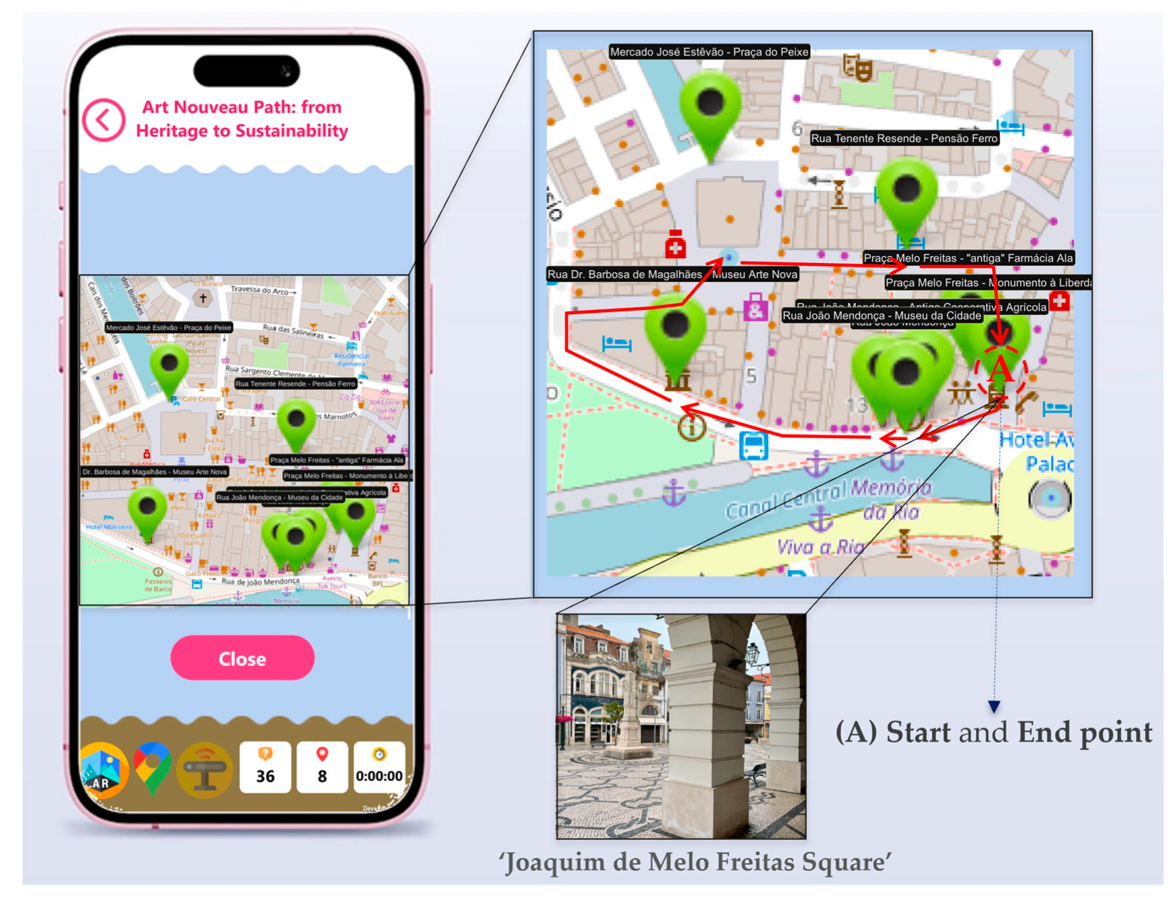
Figure 2.
Examples of in-app Aveiro’s Art Nouveau heritage used as AR markers, and its contents. This allows engaging interface between real-world and AR content [19].
Figure 2.
Examples of in-app Aveiro’s Art Nouveau heritage used as AR markers, and its contents. This allows engaging interface between real-world and AR content [19].
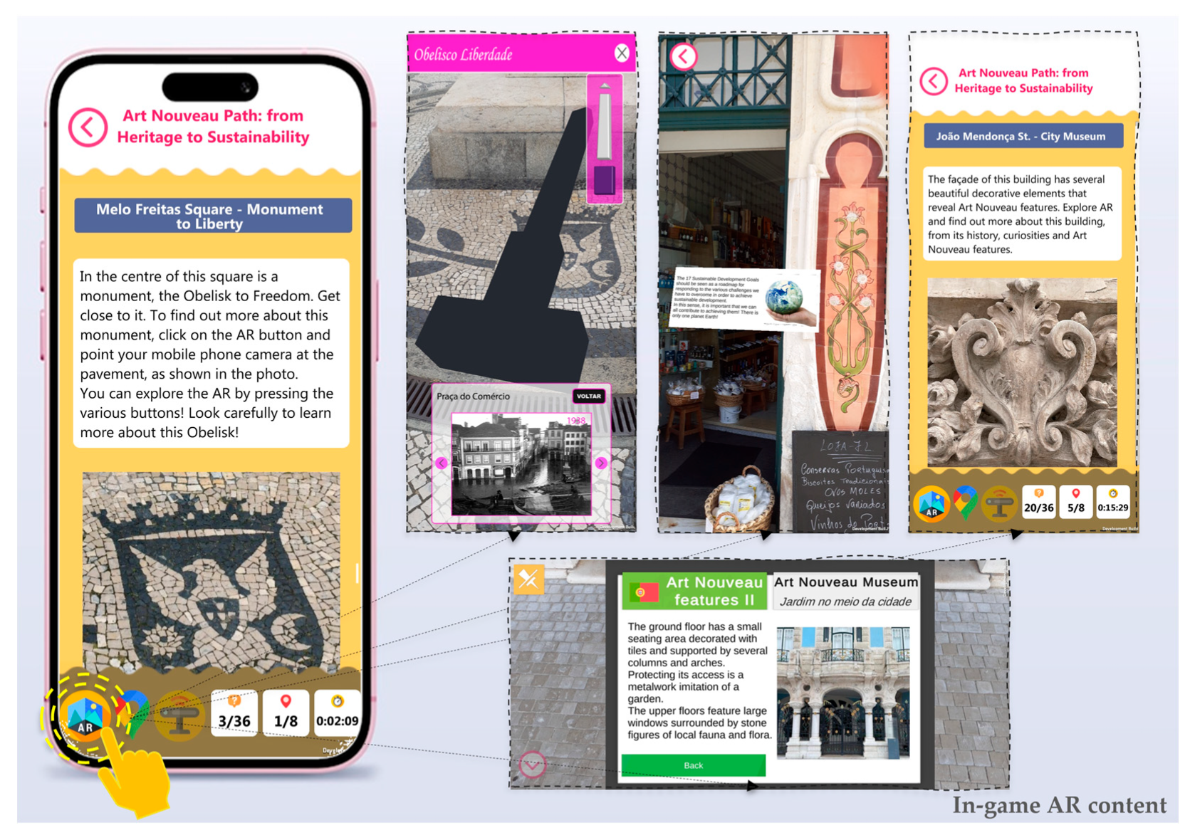
Figure 3.
EduCITY app (version 1.3) cartographic interface.
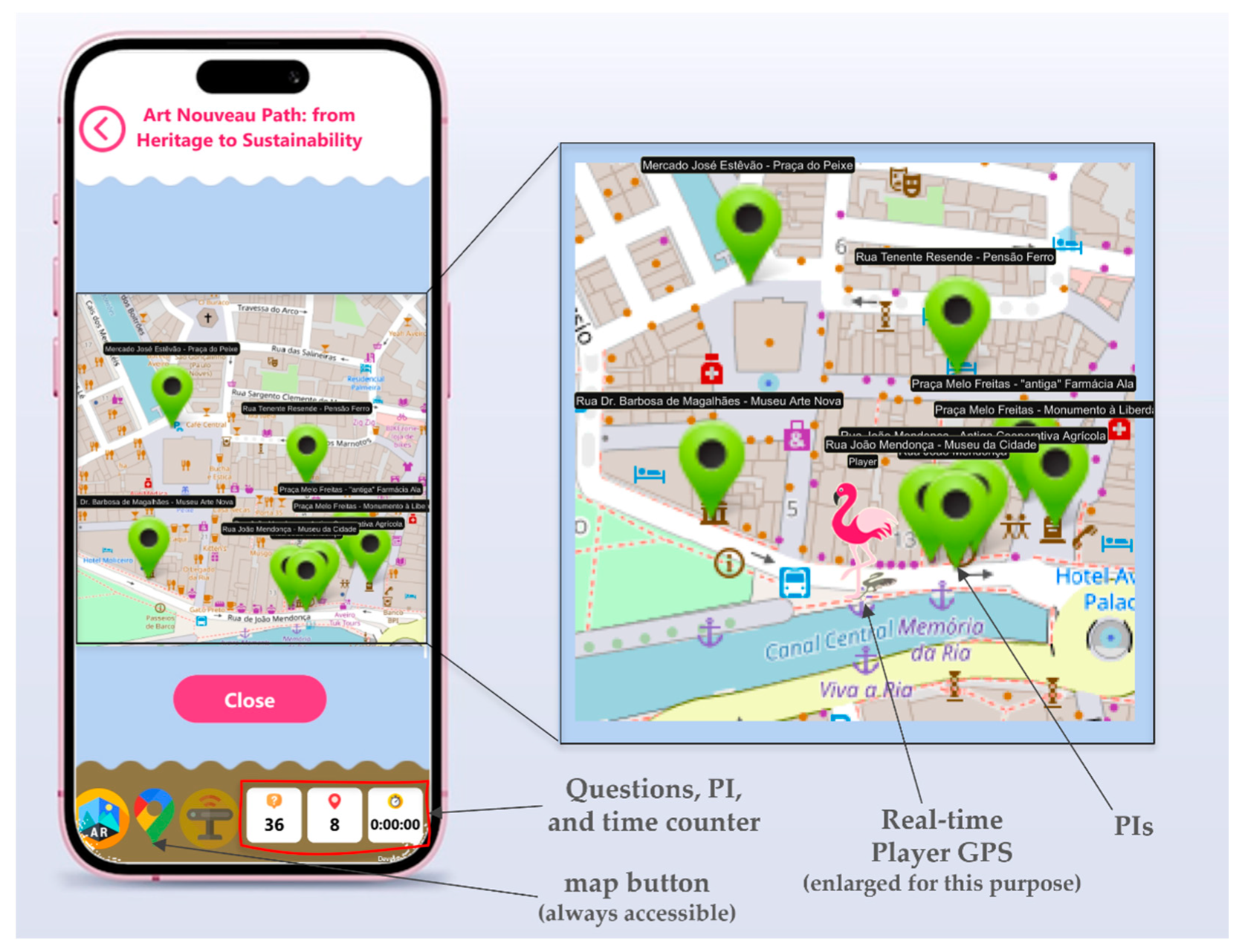
Figure 4.
‘Obelisk of Freedom’ (PI 1) and old ‘Ala Pharmacy’ (PI 2) at ‘Joaquim de Melo Freitas Square‘, MARG’s initial and final area.
Figure 4.
‘Obelisk of Freedom’ (PI 1) and old ‘Ala Pharmacy’ (PI 2) at ‘Joaquim de Melo Freitas Square‘, MARG’s initial and final area.
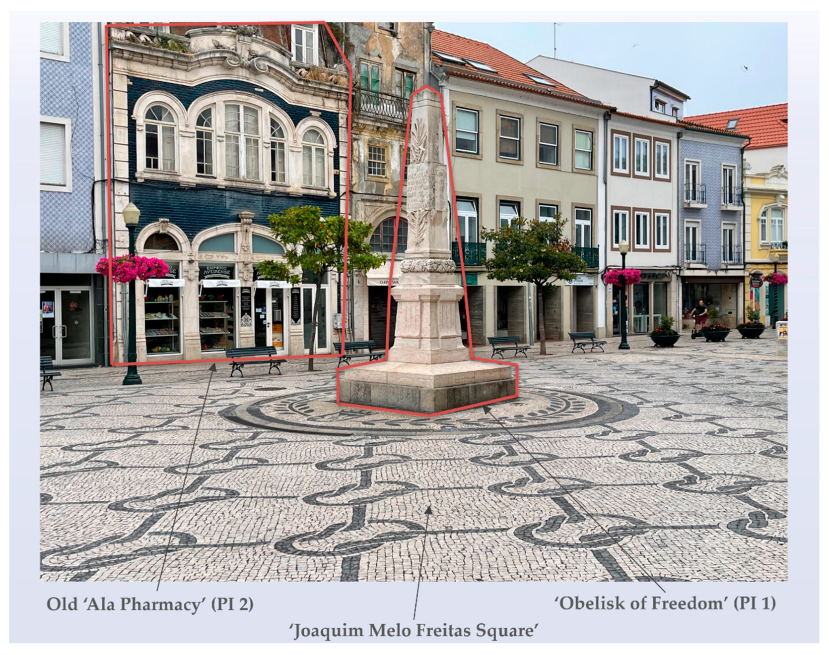
Figure 5.
‘João Mendonça Street’ (PI 3), the ‘Old Agriculture Cooperative (PI 4), and the ‘Aveiro’s City Museum’ (PI5).
Figure 5.
‘João Mendonça Street’ (PI 3), the ‘Old Agriculture Cooperative (PI 4), and the ‘Aveiro’s City Museum’ (PI5).
Figure 6.
‘Aveiro’s City Museum’ (PI 5) and in-app PI 5 AR marker.
Figure 7.
‘Art Nouveau Museum’ (PI 6) and in-app PI 6 AR marker.
Figure 8.
‘Old Fish Market’ (PI 7).
Figure 9.
‘Pensão Ferro’ (old guesthouse) (PI 8) at ‘Lieutenant Rezende’ Street.
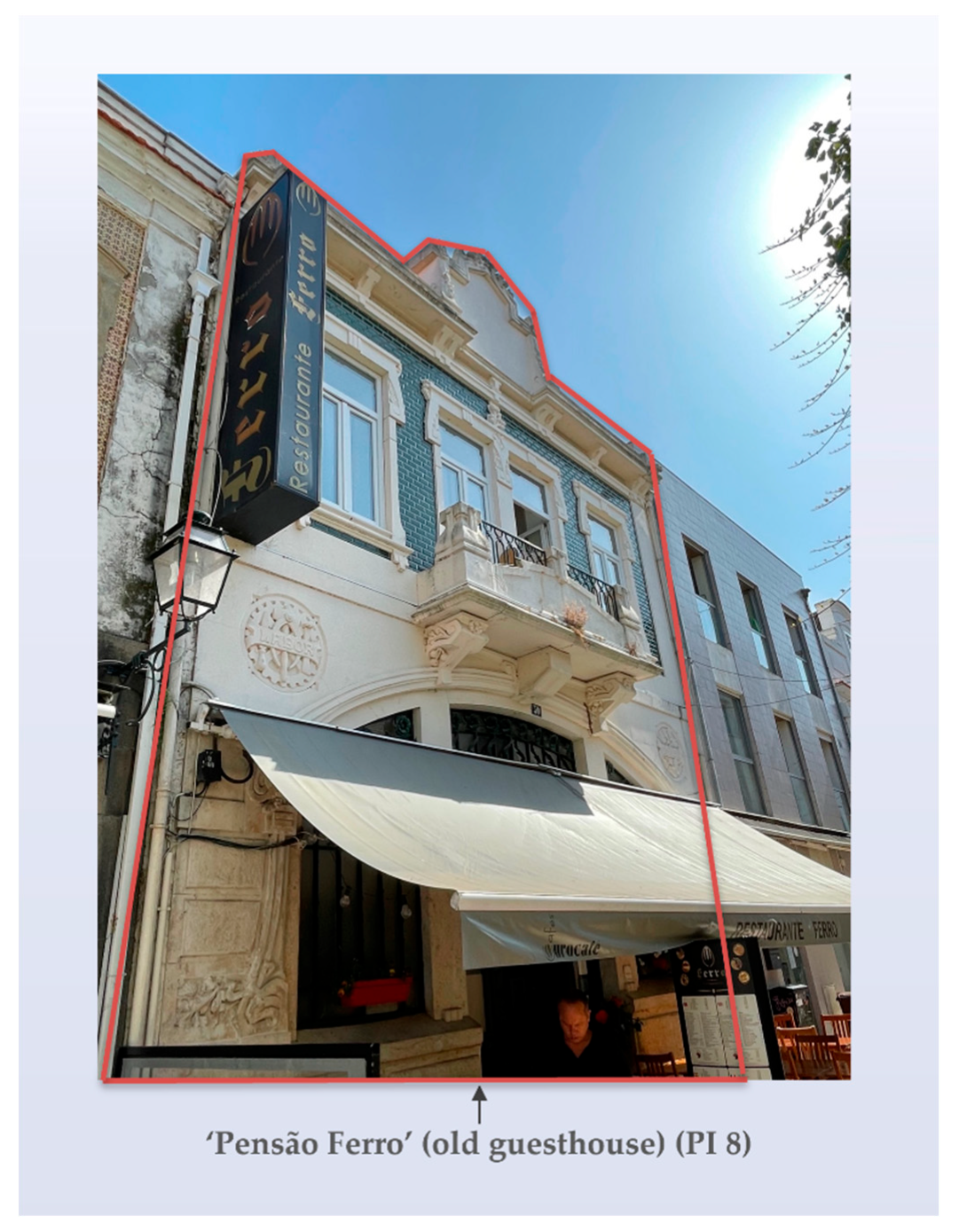
Figure 10.
Francisco da Silva Rocha (Architect).
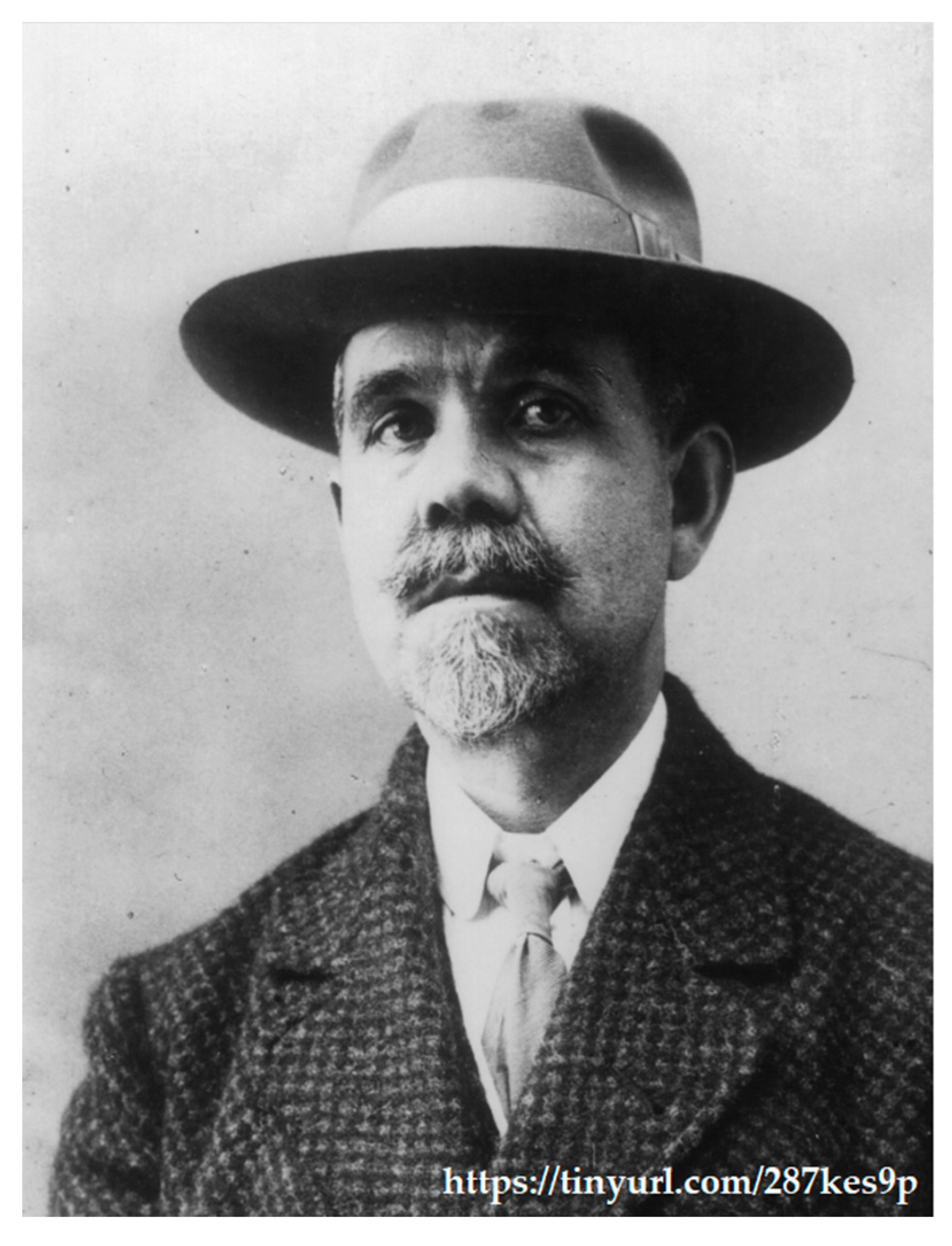
Figure 11.
In-app adobe example.
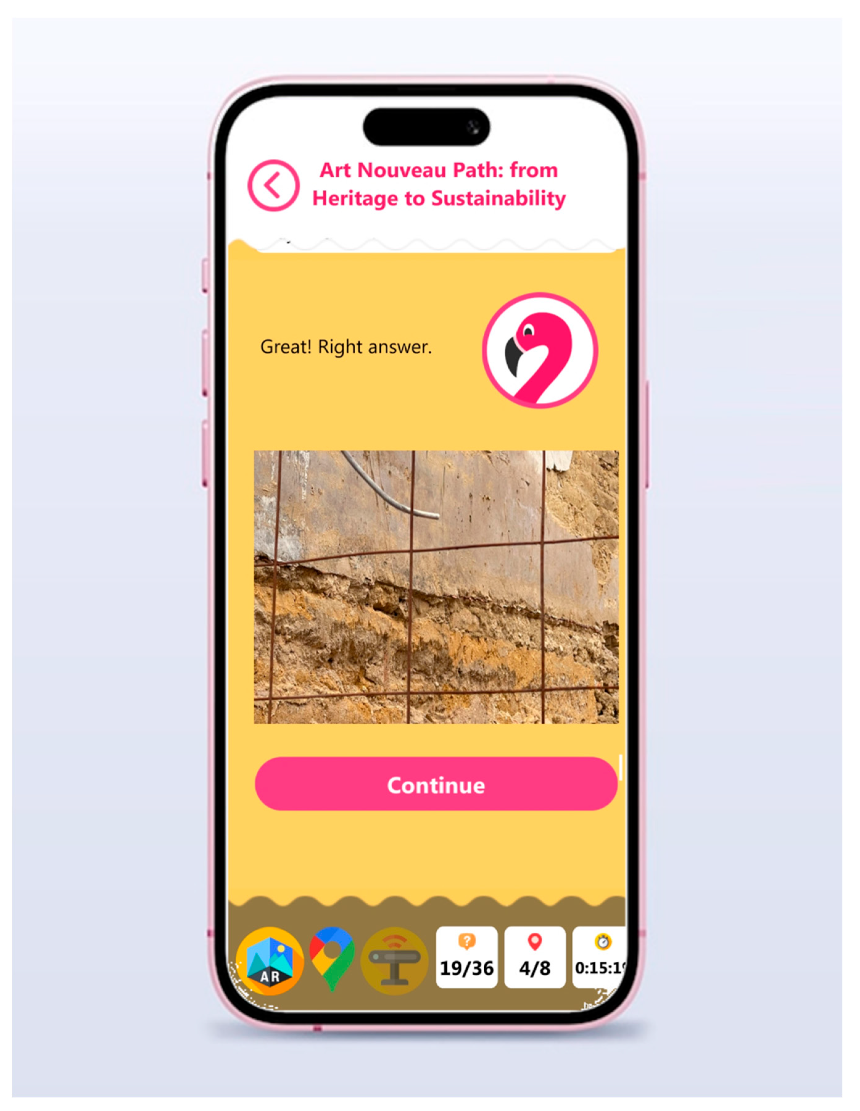
Figure 12.
Aggregate distribution of correct versus incorrect responses across all 4,248 group–item interactions.
Figure 12.
Aggregate distribution of correct versus incorrect responses across all 4,248 group–item interactions.
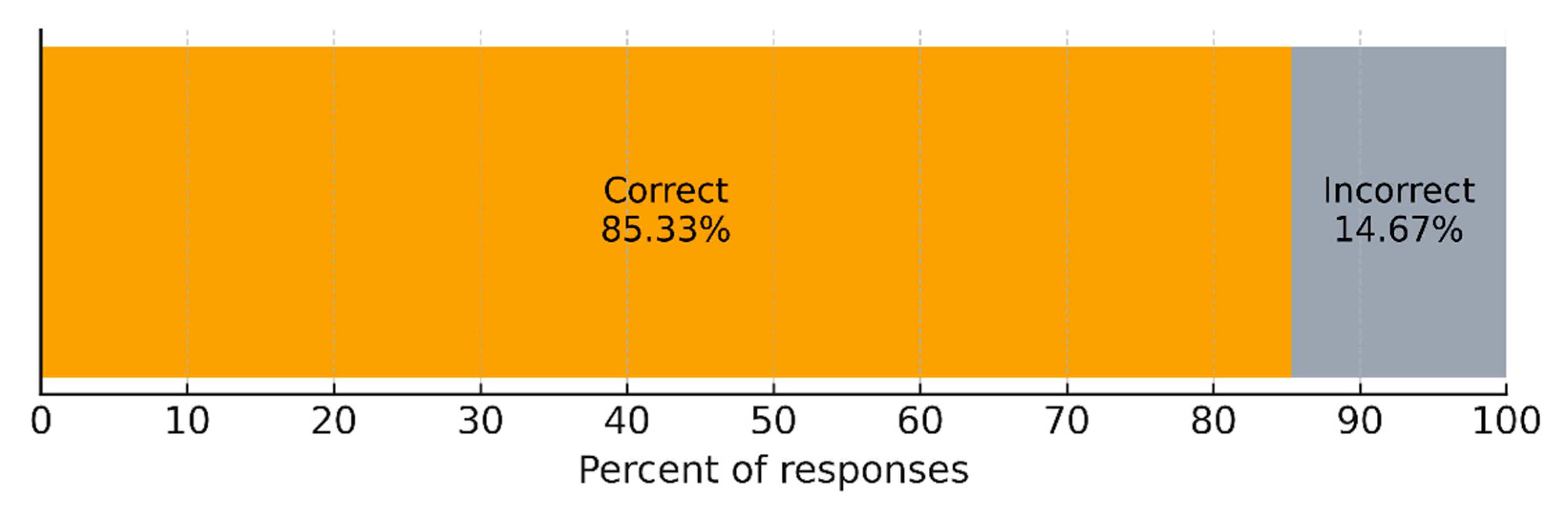
Figure 13.
Absolute counts of correct and incorrect responses across the 4,248 group-item interaction.
Figure 13.
Absolute counts of correct and incorrect responses across the 4,248 group-item interaction.
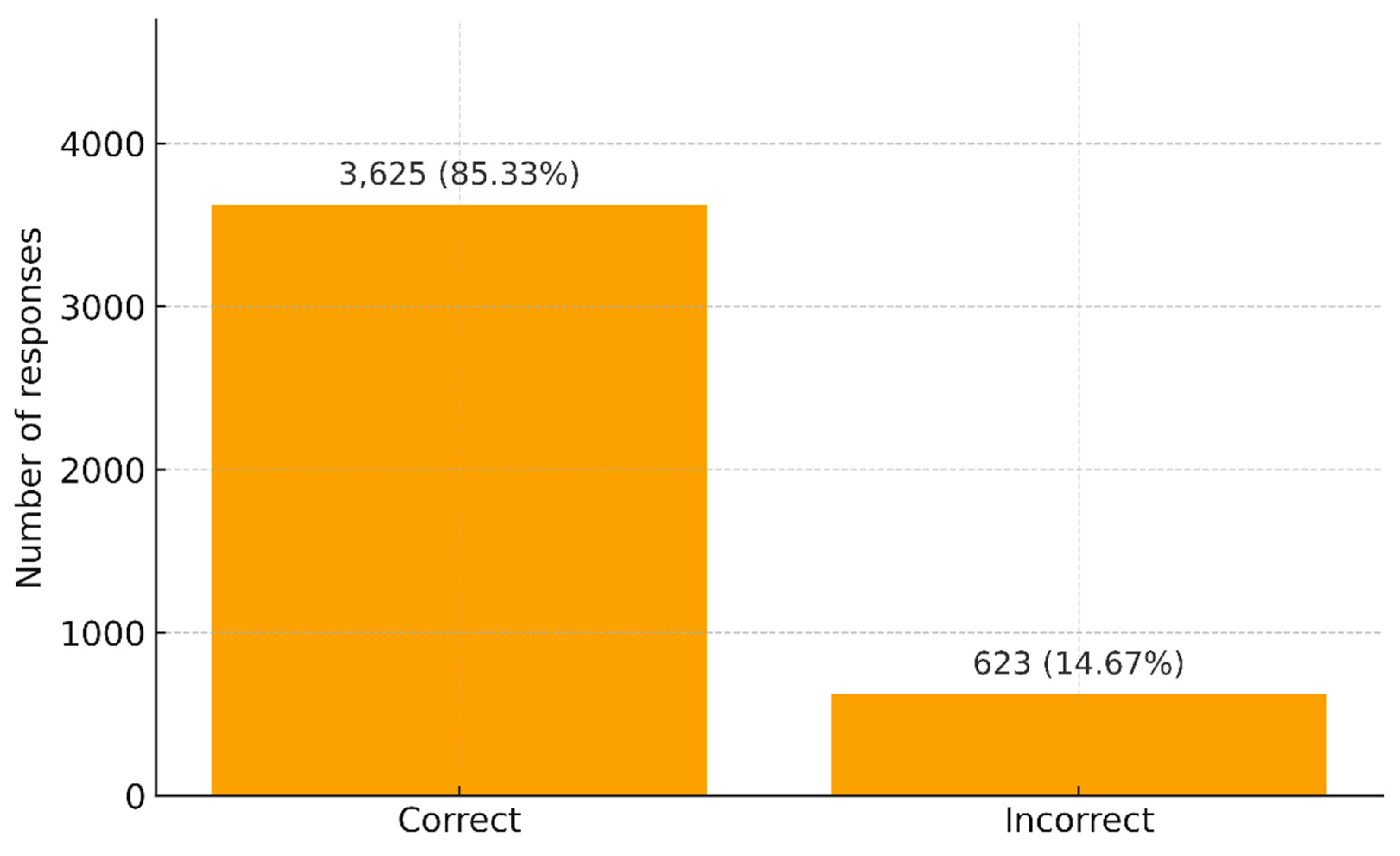
Figure 14.
Item-level accuracy (%) across the 36 quiz items of the Art Nouveau Path (N = 118 groups, 4,248 responses).
Figure 14.
Item-level accuracy (%) across the 36 quiz items of the Art Nouveau Path (N = 118 groups, 4,248 responses).
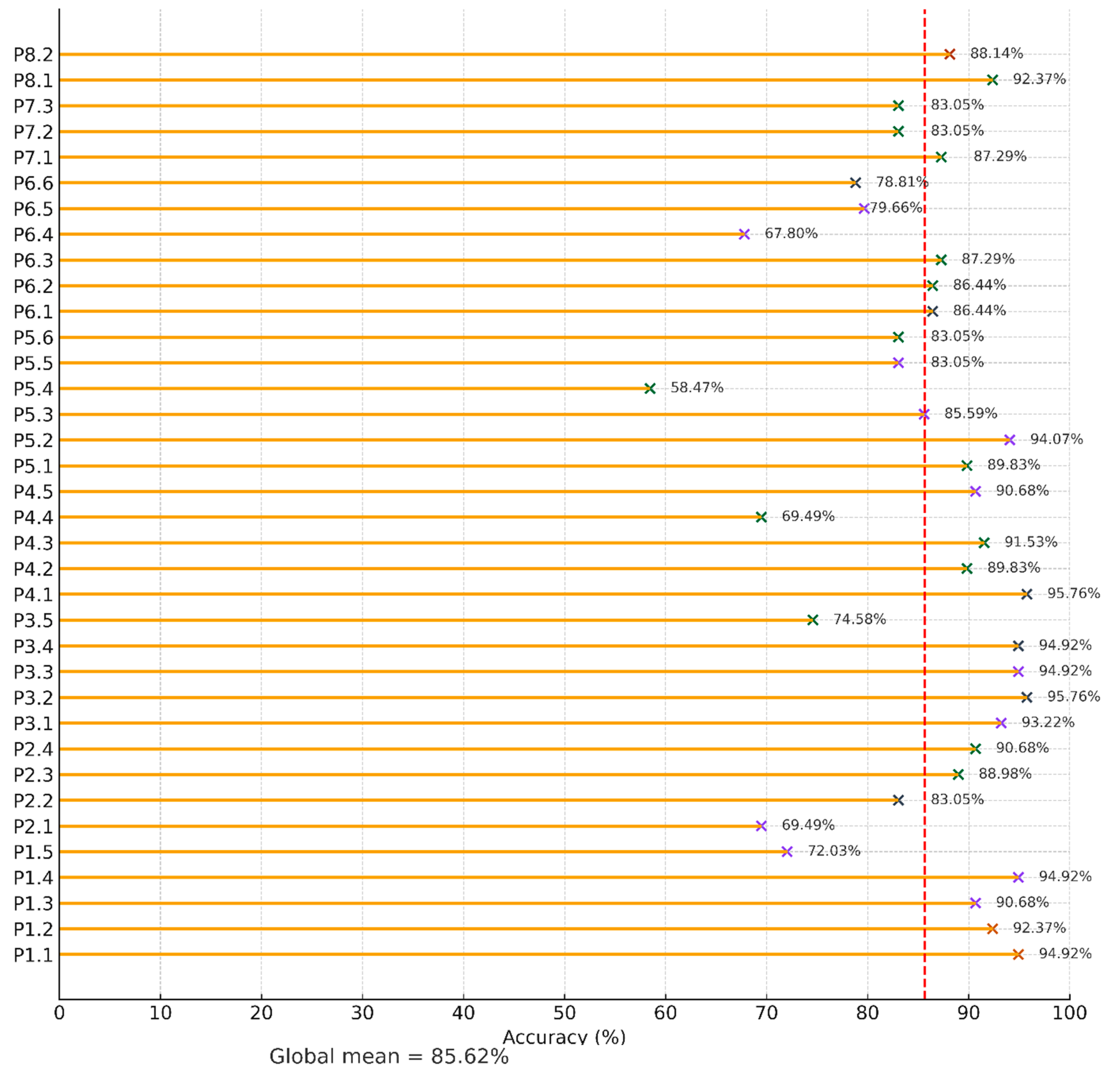
Figure 15.
Correct (orange) versus incorrect (grey) responses for each quiz item, grouped by PI (PI 1 to PI 8).
Figure 15.
Correct (orange) versus incorrect (grey) responses for each quiz item, grouped by PI (PI 1 to PI 8).
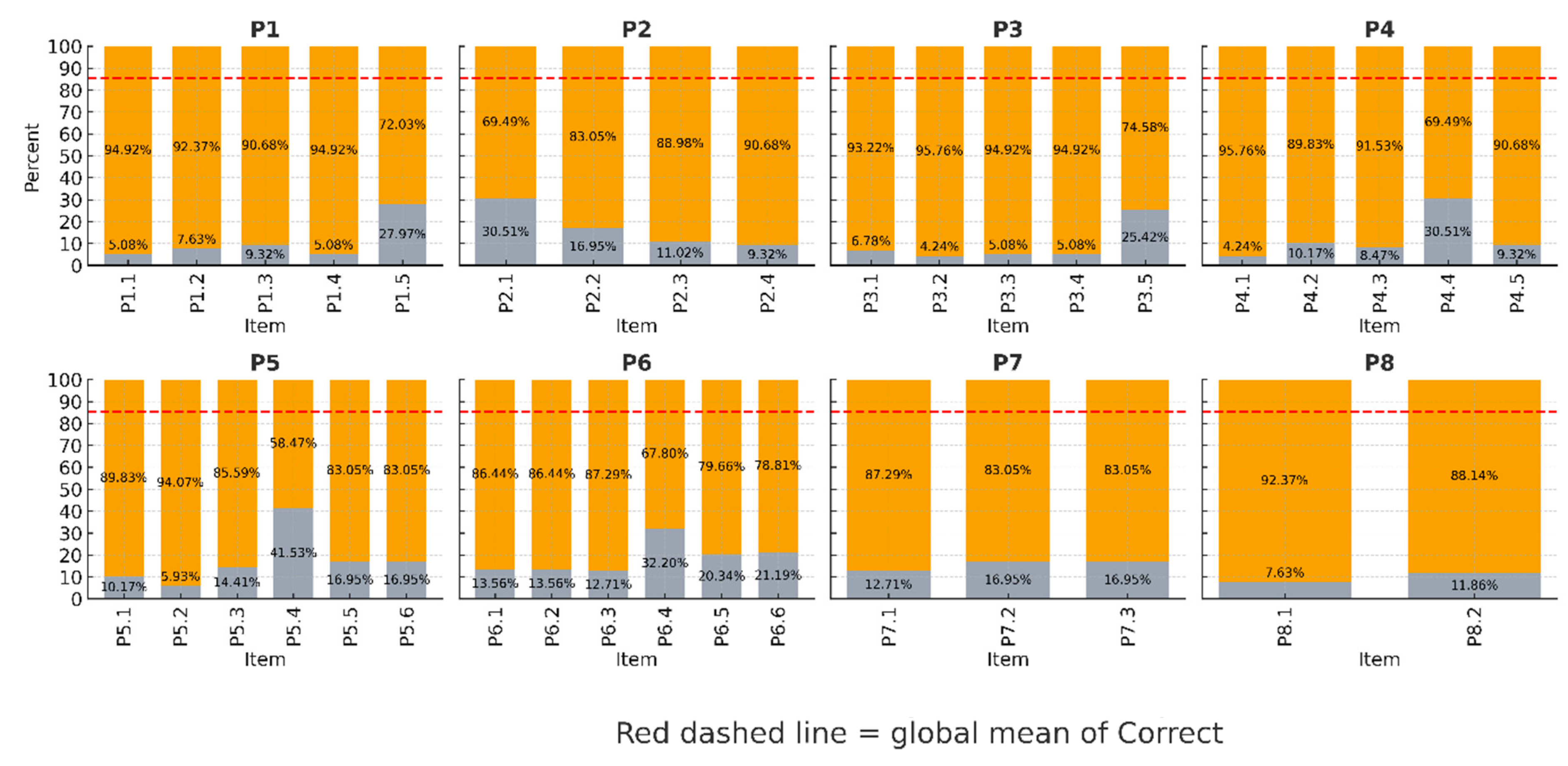
Figure 16.
Mean accuracy (%) across items grouped by media type.
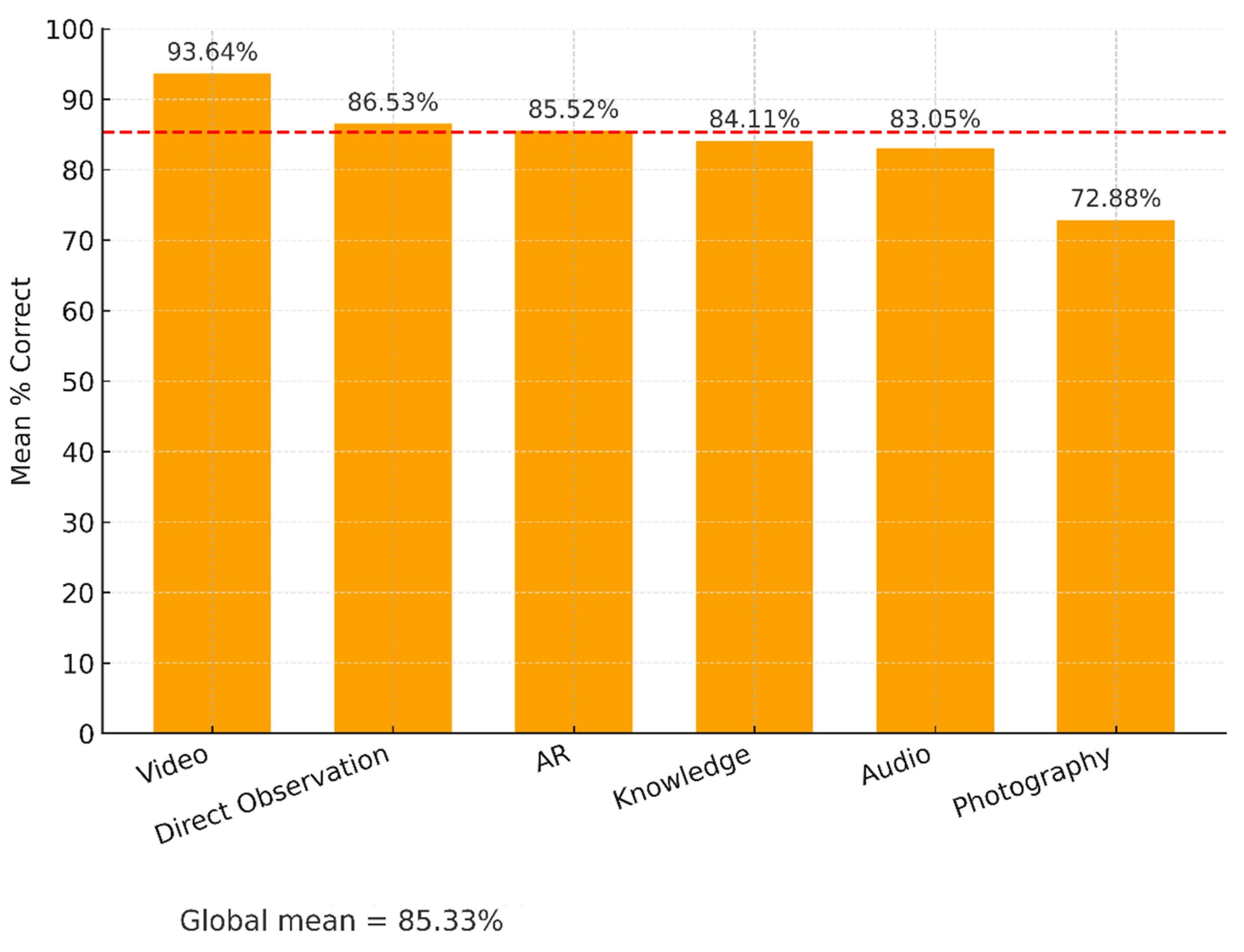
Figure 17.
Mean accuracy (%) at each PI along the Art Nouveau Path.
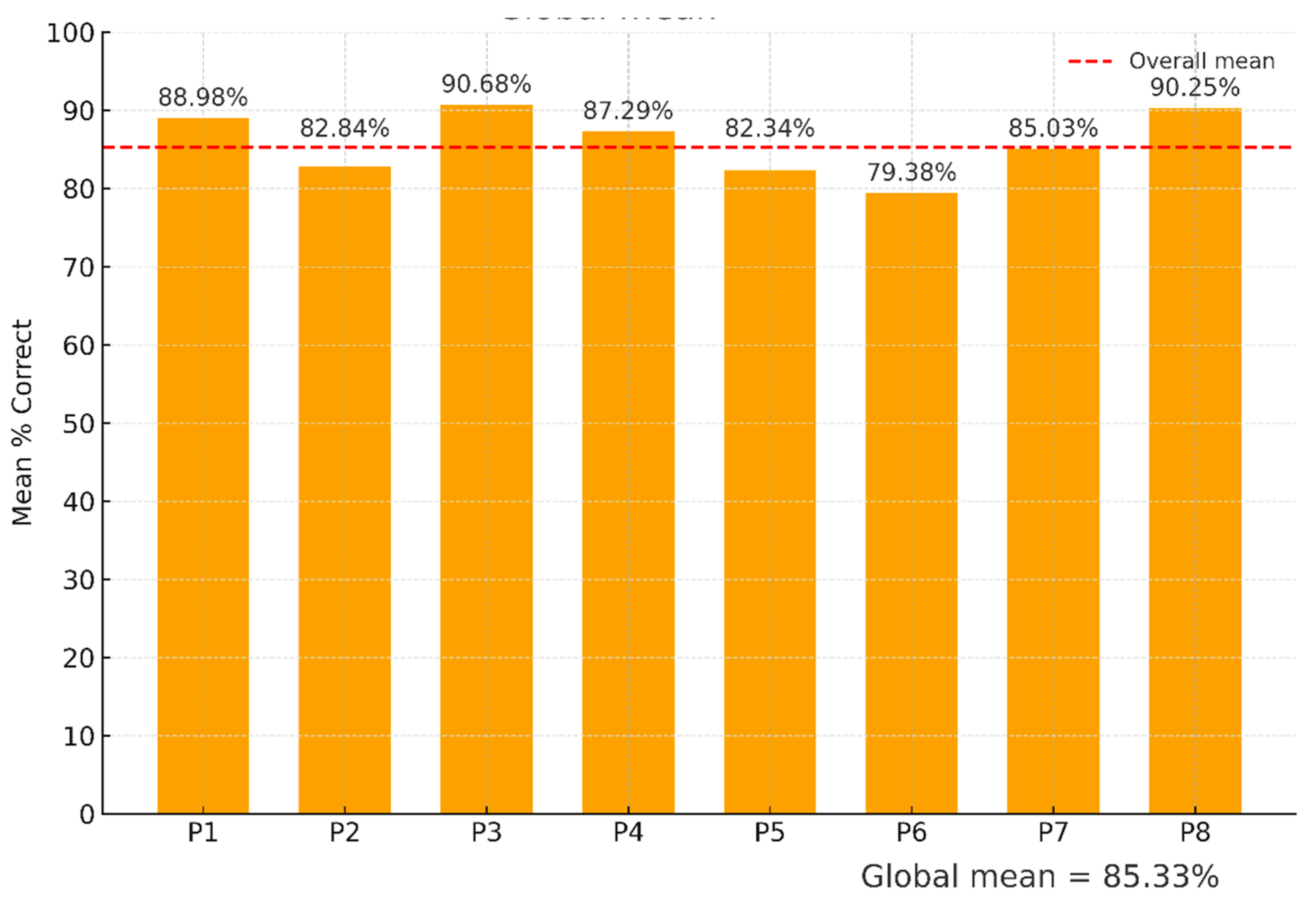
Figure 18.
Distribution of session durations across all groups.
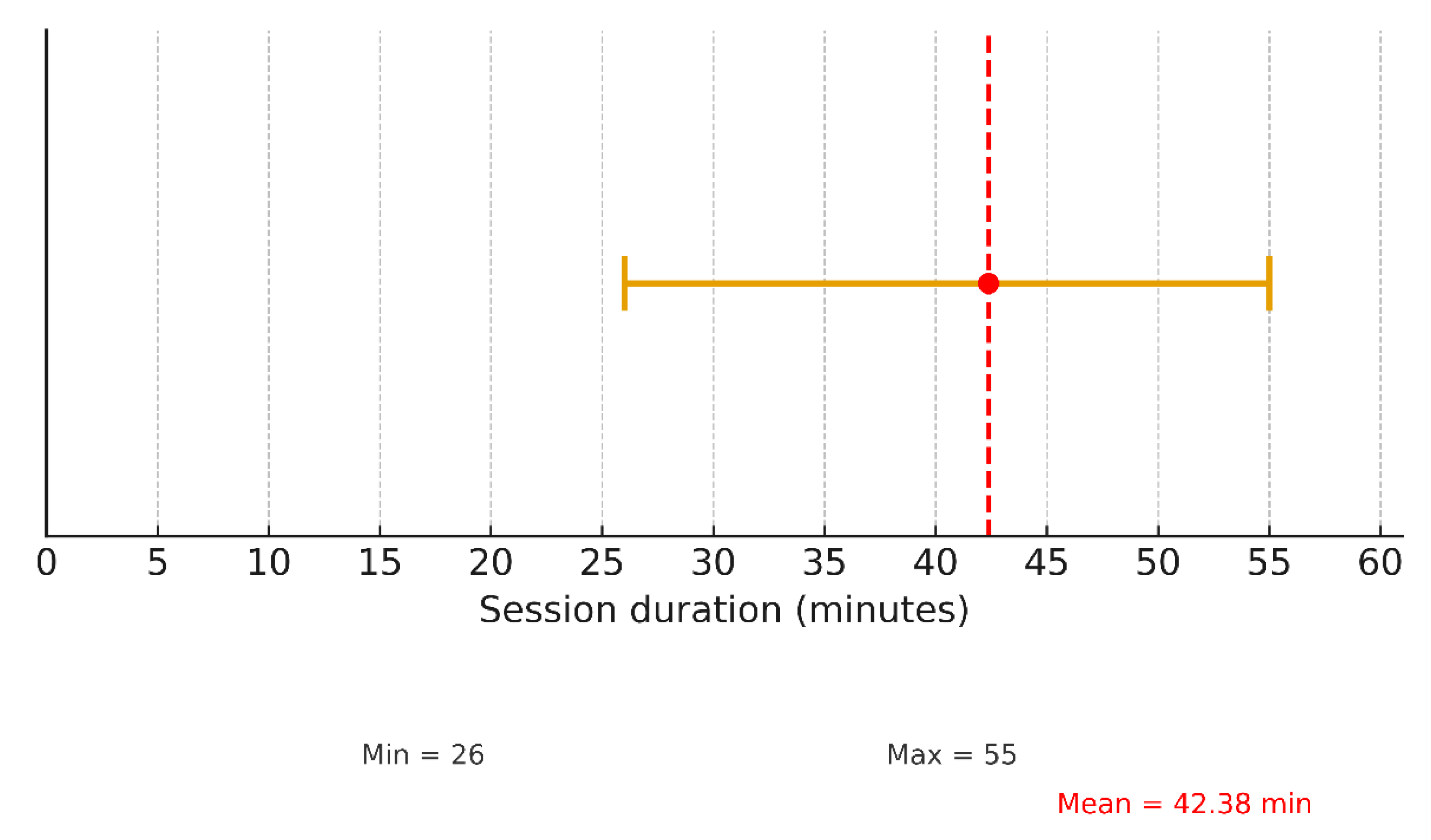
Table 2.
Curriculum validation perspectives based on T1-R.
| Discipline | Curricular Relevance |
Interdisciplinary Potential | Critical/Reflective Emphasis | Age Appropriateness |
Sustainability Implications |
|---|---|---|---|---|---|
| History | Links to 9th grade and 11th grade | Bridges with Sciences (environmental changes) and Arts (aesthetic readings of facades) | Comparison of old vs. current photographs; reflection on memory, urban change, and heritage | Suitable for 3rd cycle; adaptable to secondary with research-based tasks | Anchors civic and political values (e.g., republican symbols) in local heritage |
| Natural Sciences | Connects with 8th grade (“Sustainability on Earth”) and topics of ecosystems, pollution, resources | Integrates biodiversity motifs with artistic facades; chemistry of acid rain on limestone | Reflection on human impact, resource management, conservation | Calibrated for 3rd cycle; scalable to secondary via case studies and environmental projects | Promotes ecological literacy and responsibility through heritage contexts |
| Visual Arts/Citizenship | Links to 3rd cycle Education Visual and secondary curricula in Drawing A/History of Arts | Combines artistic expression with history and sustainability debates | Civic reflection on “Who protects heritage?” and role of art in public space | Accessible for younger students; adaptable for secondary via design portfolios and urban intervention projects | Strengthens cultural identity, creativity, and civic responsibility |
Disclaimer/Publisher’s Note: The statements, opinions and data contained in all publications are solely those of the individual author(s) and contributor(s) and not of MDPI and/or the editor(s). MDPI and/or the editor(s) disclaim responsibility for any injury to people or property resulting from any ideas, methods, instructions or products referred to in the content. |
© 2025 by the authors. Licensee MDPI, Basel, Switzerland. This article is an open access article distributed under the terms and conditions of the Creative Commons Attribution (CC BY) license (http://creativecommons.org/licenses/by/4.0/).
Copyright: This open access article is published under a Creative Commons CC BY 4.0 license, which permit the free download, distribution, and reuse, provided that the author and preprint are cited in any reuse.


