

Submitted:
09 October 2024
Posted:
11 October 2024
You are already at the latest version
Abstract
This study uses Historical Geographic Information Systemsand spatial analysis methods like Space Syntax and Kernel Density Estimation to examine the urban spatial evolution of Xi'an from the Five Dynasties (907 CE) to the early People's Republic of China (1949 CE). By focusing on six historical periods, it reveals the city's transition from a centralized layout to a decentralized, multi-center form. The research shows that Xi'an's spatial structure was shaped by political, economic, cultural, and environmental forces. The Ming and Qing dynasties, in particular, saw economic diversification and the influence of the Silk Road, driving the city's outward expansion and the formation of multiple functional zones. The study also discusses how these historical changes offer valuable lessons for modern urban planning, particularly in balancing cultural heritage preservation with modernization. Overall, the findings provide fresh insights into the long-term urban development of historic cities and offer practical strategies for modern urban planning.
Keywords:
Historical GIS
; Xi'an
; Urban Spatial Structure
; Sustainable Urban Development
1. Introduction
In recent years, the concept of the "Spatial Turn" has brought a trans-formative shift across many academic disciplines in the humanities and social sciences[1,2]. This shift emphasizes moving beyond traditional analyses that focus on micro-level cultural elements, such as texts and artifacts, and urges scholars to consider space as an active force that shapes human activity. Rather than being seen as a passive backdrop for events, spatial configurations are now understood as dynamic elements that interact with social, political, and cultural processes[3]. This new perspective introduces a more nuanced way of analyzing how historical phenomena interact with and reshape spatial environments.
One of the most significant outcomes of the "Spatial Turn" is the widespread adoption of Geographic Information Systems (GIS) for historical and urban studies. GIS allows researchers to visualize and analyze complex spatial relationships over time, providing a more precise understanding of how cities and regions evolve[4]. David J. Bodenhamer, a leading figure in spatial humanities, introduced the concept of "Deep Maps" which integrates physical geography, social interactions, and cultural narratives into layered spatial data[5,6,7]. This approach aligns with the principles of the "Spatial Turn" by offering a multidimensional exploration of space, revealing how spatial arrangements have historically influenced human experiences and societal development.
Among the technological advancements influenced by the "Spatial Turn," Historical GIS (HGIS) has emerged as a crucial tool for studying the evolution of urban spaces. HGIS combines historical maps with modern GIS techniques, enabling scholars to trace the development of cities across different historical periods with greater accuracy. It allows for the identification of patterns in urban growth and decline, providing insight into the political, economic, and cultural factors that drive these changes[8,9,10]. For historically significant cities like Xian, HGIS offers an unparalleled opportunity to reconstruct long-term spatial transformations, offering both historical insight and valuable information for modern urban planning.
Xian, historically known as Chang'an, is one of China's most culturally and politically important cities, with over 5,000 years of continuous habitation[11]. It served as the capital of numerous Chinese dynasties, including the Zhou, Qin, Han, and Tang, and was a major hub along the ancient Silk Road. Xian urban development reflects significant political, economic, and cultural shifts, making it an ideal case for spatial analysis. Despite its historical prominence, however, there is a relative lack of comprehensive studies that explore the city's spatial evolution using modern HGIS methodologies. Most previous research has relied on traditional cartographic analysis, which, while valuable, does not fully harness the analytical precision and spatial insights provided by HGIS.
This study aims to fill the gap in existing research by employing HGIS to analyze the evolution of Xians urban spatial structure from the Five Dynasties period (907–960 CE) to the early Peoples Republic of China (1949 CE). Utilizing spatial analysis methods such as Space Syntax and Kernel Density Estimation (KDE), and drawing from The Historical Atlas of Xian, this research identifies the trends in the city's spatial transformation. Two major phases of development were observed: the simpler, centralized layouts of the Five Dynasties, Northern Song, and Yuan periods, and the more complex, decentralized structure of the Ming, Qing, and PRC periods. These changes were influenced by a dynamic interplay of political, economic, cultural, and environmental factors, including the city's need to adapt to external military threats and internal socio-economic shifts.
In addition to historical significance, this study highlights the practical applications of HGIS for modern urban planning and cultural heritage preservation. By visualizing spatial data across different historical periods, the research uncovers long-term patterns in urban development that offer critical insights for contemporary policymakers. As Xian continues to modernize, these insights provide valuable guidance for balancing urban growth with the preservation of the city's rich cultural heritage, ensuring that future development strategies are informed by lessons from the past.
2. Literature Review
The study of urban spatial evolution relies heavily on the integration of historical maps with the analytical tools like Geographic Information Systems (GIS). Historically, maps have played a pivotal role in urban studies, primarily as instruments of governance, state-building, and territorial management. Early research on historical maps was primarily technical, focusing on cartographic production methods and their use as tools for navigation and administration[12,13]. However, these approaches often overlooked the broader socio-political contexts within which maps were created, treating them merely as static representations of geographic space.
More recent scholarship has shifted toward a more nuanced understanding of maps as socio-political constructs, reflecting the ideological, cultural, and power dynamics of their time[14,15]. This perspective is in line with the "Spatial Turn" in the humanities, which encourages scholars to see space as an active participant in shaping human experiences. Maps are now recognized not only for their geographic accuracy but also for their capacity to convey the social and political structures of their respective historical periods. This shift in understanding has laid the groundwork for the integration of maps into broader analytical frameworks, such as GIS.
The "Spatial Turn" emerged in the late 20th century as a transformative framework, emphasizing the importance of spatial relationships in social and historical analysis[16]. This approach challenges the traditional focus on temporal and narrative history by introducing space as a element that interacts with cultural, political, and economic processes. Scholars such as Henri Lefebvre have argued that space is socially produced, meaning that the arrangement and organization of physical space both reflects and reinforces power structures and social hierarchies[17]. This theoretical shift has enabled a more complex understanding of historical cities, where spatial organization is not simply a backdrop but an active agent in urban development.
The adoption of Geographic Information Systems (GIS) in historical research has allowed for the visualization and analysis of spatial data in ways previously impossible. By layering historical maps with spatial datasets, researchers can now trace the development of cities over time, identifying patterns of growth, decline, and transformation. GIS tools such as Kernel Density Estimation (KDE) and Space Syntax provide valuable methods for quantifying spatial relationships and understanding how urban spaces are organized to influence social behaviors and economic activities[18,19].
While GIS has revolutionized the field of historical cartography, the development of Historical Geographic Information Systems (HGIS) has been particularly impactful in urban historical studies. HGIS integrates historical maps with modern GIS techniques, allowing researchers to analyze changes in urban form across different historical periods. This approach not only helps visualize long-term spatial transformations but also uncovers the socio-political and cultural forces driving those changes[20,21,22]. For historically significant cities like Xi'an, HGIS offers an unparalleled opportunity to trace urban evolution in response to shifting political regimes, economic conditions, and cultural exchanges.
Several landmark HGIS research initiatives have demonstrated the potential of this methodology for reconstructing urban spatial history. Projects like the China Historical GIS (CHGIS), the Great Britain Historical GIS (GBHGIS), and the Digital Atlas of Roman and Medieval Civilizations (DARMC) have set new standards for interdisciplinary spatial studies. These projects facilitate the reconstruction of historical landscapes, settlement patterns, and socio-economic dynamics across centuries, providing comprehensive models for analyzing urban transformations in both Western and non-Western contexts[23,24].
Despite these advances, HGIS faces several challenges, particularly concerning the quality and accuracy of historical maps. Many maps contain distortions, inconsistent scales, and incomplete data, complicating efforts to align them with modern GIS frameworks. The process of Geo-referencing these maps essential for their integration into GIS requires meticulous attention, as even minor spatial misalignment's can result in significant inaccuracies in the analysis[25,26,27]. In addition, the temporal scope of historical maps often poses challenges, as datasets from different eras may represent spatial arrangements that do not directly correspond to one another. Addressing these challenges is critical to ensuring the reliability of HGIS-based research.
Recent technological advancements in artificial intelligence (AI) and machine learning have further enhanced the precision and capabilities of HGIS[28]. AI tools are increasingly used to automate the digitization and Geo-referencing of historical maps, while machine learning algorithms help identify patterns in large, complex datasets[29]. These innovations have opened up new avenues for spatial research, enabling more sophisticated analyses of historical urban development. For example, AI-driven algorithms can now detect long-term spatial patterns in migration, economic activity, and cultural exchange, providing deeper insights into how cities like Xi'an evolved over time[30,31].
Table 1 presents a summary of major research reviews in Historical GIS, highlighting figures, research outcomes, methods, and challenges in the field. This table demonstrates the diverse research directions and outlines the main difficulties encountered in the digitization and spatial analysis of historical maps. It also provides an overview of how various institutions have approached these challenges, offering valuable context for understanding the current state of HGIS research.
The integration of HGIS methodologies into historical urban research offers profound insights into the evolution of cities like Xi'an. Yet, the application of HGIS in Chinese urban studies remains relatively underdeveloped compared to its use in Western contexts[37,38]. Existing research on Xi'an has typically relied on traditional cartography and textual sources, which provide valuable information but lack the analytical depth afforded by HGIS. There is a growing need for comprehensive studies that employ HGIS to explore the long-term spatial transformations of Chinese cities[39,40].
This study addresses this gap by applying HGIS techniques to analyze the spatial evolution of Xi'an's urban structure from the Five Dynasties period (907–960 CE) to the early PRC period (1949 CE). By integrating historical maps with spatial analysis methods like Space Syntax and KDE, the research provides a detailed examination of how political, economic, and cultural forces shaped the city's urban layout across different historical periods[41]. The insights gained from this study offer valuable contributions to the fields of historical geography and urban planning, particularly in balancing urban growth with the preservation of Xi'an's rich cultural heritage[42].
3. Data Sources and Methods
3.1. Data Sources
This study dependent to a large extent on the The Historical Atlas of Xian, edited by Shi Nianhai, as its primary data source. This atlas is a highly authoritative compilation of historical maps that documents the spatial evolution of Xian over more than a millennium. The maps offer a comprehensive visual record of the city's urban form, encompassing elements such as street networks, administrative centers, religious sites, residential districts, and fortifications. These maps, which span several dynastic periods, provide invaluable insight into the socio-political and economic development of the city across different eras.
What distinguishes The Historical Atlas of Xian is its rigorous methodology. Shi Nianhai and his team meticulously verified the maps using a combination of documentary sources and extensive field surveys, ensuring a high degree of historical accuracy. This attention to detail allows researchers to track the changing spatial configurations of Xian and gain insight into how various political regimes, economic conditions, and cultural shifts influenced the city's structure over time[43].
In this study, these historical maps have been digitized and integrated into a Geographic Information System (GIS) framework, enabling dynamic temporal and spatial analysis[44]. By overlaying historical maps with modern spatial data, the GIS framework facilitates the examination of how Xians urban form evolved across different dynasties. This approach not only offers a historical account of the city's growth but also allows for an analysis of spatial relationships between the urban features, such as the proximity of marketplaces to administrative centers or the placement of religious buildings relative to residential zones. By exploring these spatial relationships, the study aims to uncover the socio-political and cultural forces that shaped the city's urban development.
To provide a structured visualization of Xians spatial evolution, six historical maps from the atlas have been selected, corresponding to pivotal periods in the city's history(Figure 1). These maps serve as critical reference points for tracking the transformation of Xian urban form and identifying significant changes in its spatial organization. The selected periods represent major shifts in political power, economic development, and cultural influences, each of which profoundly impacted the city's urban layout. The selected periods and maps are as follows:
Five Dynasties Period (907–960 CE) : This map illustrates the early development of the "New City," which emerged during this politically fragmented era, reflecting the city's shift from a Tang dynasty capital to a regional military and administrative hub.
Northern Song Dynasty (960–1127 CE): This map shows the Jingzhao Prefecture, highlighting the city's strategic significance in the northwestern region, despite its loss of status as the imperial capital.
Yuan Dynasty (1271–1368 CE): The map of Fengyuan (modern Xi'an) depicts the Mongol rulers' influence on urban planning, emphasizing military defense and administrative efficiency.
Ming Dynasty (1368–1644 CE): This period saw the construction of Xi'an's famous outer city walls and fortifications, which played a critical role in expanding the city's spatial footprint.
Qing Dynasty (1644–1912 CE): The map from this period reflects the city's transformation into a regional economic center, with expanded marketplaces and new cultural institutions.
People's Republic of China (1949 CE onwards): This map captures Xi'an's early post-war reconstruction and industrialization efforts, highlighting the spatial shifts brought by modern urban planning under the PRC.
Each of these maps plays a critical role in understanding Xi'an's long-term urban evolution, particularly in terms of how political regimes, economic priorities, and cultural influences shaped the city's form and function.
3.2. Methods
This study applies the spatial analysis techniques to investigate the evolution of Xians urban form over more than a millennium, from the Five Dynasties to the early Peoples Republic of China. By digitizing and Geo-referencing historical maps, GIS allows for a dynamic and precise examination of changes in the city's spatial configuration over time. This study employs two primary spatial analytical methods within the GIS framework: Space Syntax and Kernel Density Estimation (KDE). These methods are instrumental in uncovering the spatial dynamics that have shaped Xians urban development across different dynasties, offering insights into the relationship between urban form, social behavior, and political power.
The choice of Space Syntax and KDE is driven by the need to analyze both the structural accessibility of Xians street network and the spatial distribution of urban features, such as religious institutions, marketplaces, and administrative centers. Figure 2 provides a visual network of the interconnections between various GIS-related research topics, illustrating the growing importance of spatial analysis in understanding historical urban environments. The interconnectedness of terms like "classification," "segmentation," and "historical maps" highlights the need for sophisticated techniques like Space Syntax and KDE to gain a deeper understanding of how urban spaces evolve in response to social, economic, and political changes.
3.2.1. Space Syntax
Space Syntax is a well-established methodology developed to quantify and analyze spatial configurations in urban environments[45]. It offers a theoretical and practical framework for understanding how the layout of space influences human movement, social interaction, and economic activity. Originally developed by Bill Hillier and Julienne Hanson at University College London, Space Syntax has since been widely adopted in both contemporary and historical urban studies[46].
In the context of historical urban research, Space Syntax is particularly valuable for analyzing street networks and public spaces within ancient cities. By breaking down urban layouts into axial lines (representing streets or movement routes), the method allows researchers to calculate spatial metrics such as connectivity, integration, and control value. These metrics provide insights into the accessibility of certain areas, the centrality of the streets, and the influence of particular spaces within the broader urban network.
Connectivity: The number of direct connections a space (e.g., a street or square) has to its adjacent spaces. Higher connectivity indicates greater accessibility and ease of movement.
Integration: The degree to which a space is accessible from all other spaces in the network. Higher integration suggests that a space serves as a central hub within the urban layout.
Control Value: The extent to which a space controls access to its neighboring spaces, reflecting the influence or dominance of a specific area within the urban network.
In this study, Space Syntax is applied to the historical maps of Xian to assess how its street network evolved over time. For example, the analysis of integration can reveal which areas of the city were most accessible and likely served as hubs of economic or political activity. By comparing these metrics across different dynastic periods, the study identifies shifts in the city's spatial organization, such as the construction of new city walls or the relocation of administrative centers. This provides a deeper understanding of how changes in governance and economic conditions impacted the city's form and function.
Application to Historical Maps: Space Syntax is particularly effective when applied to the historical maps of Xian because it quantifies spatial relationships that are not immediately apparent from visual inspection alone. By measuring the accessibility and centrality of streets and public spaces across different historical periods, the method reveals how Xians urban form adapted to political and economic changes. For example, during the Ming Dynasty, the construction of the outer city wall expanded the city's spatial footprint, which likely altered movement patterns within the city. Space Syntax can quantify these changes, offering a clearer picture of how urban life was reorganized.
3.2.2. Kernel Density Estimation (KDE)
Kernel Density Estimation (KDE) is a statistical method used to estimate the probability density function of a given dataset. In spatial analysis, KDE is employed to visualize the density of urban features, such as buildings, marketplaces, or population clusters[47,48]. KDE provides a continuous surface that highlights areas of high and low density, allowing researchers to identify spatial patterns that are not easily visible in raw data.The one-dimensional KDE formula is typically expressed as:
where:
- is the estimated density at point x,
- is the number of sample points,
- h is the bandwidth, which controls the smoothness of the density estimate,
- K(.) is the kernel function, which determines the shape of the curve around each data point,
- xi are the individual sample points in the dataset.
In this study, KDE is applied to the spatial data derived from the digitized historical maps of Xian to analyze the distribution of urban elements, such as religious institutions, administrative centers, and residential areas. By mapping the density of these features over time, KDE enables the study to identify trends in the city's development, such as the clustering of religious buildings in certain areas or the expansion of residential zones during specific periods.
Application to Historical Maps: When applied to historical maps, KDE allows for a detailed visualization of how the density of urban features evolved over time. For instance, KDE can be used to analyze the spatial concentration of religious buildings during the Tang and Ming dynasties, providing insights into the role of religion in shaping the city's spatial layout. Similarly, by mapping the density of marketplaces, the study can explore how economic activity was distributed across the city, revealing patterns of trade and commerce that influenced urban growth.
3.3. Integration of Space Syntax and KDE
The integration of Space Syntax and KDE offers a powerful approach for analyzing the spatial dynamics of historical cities. While Space Syntax provides a detailed analysis of the accessibility and connectivity of urban spaces, KDE complements this by visualizing the density and distribution of urban features. By combining these two methods, the study is able to generate a comprehensive understanding of how Xians urban form evolved in response to changing political, economic, and cultural conditions.
For example, by overlaying the results from Space Syntax and KDE, the study can identify how the most accessible streets (as determined by Space Syntax) intersected with areas of high population density (as determined by KDE). This integrated approach allows for a more nuanced analysis of how urban spaces were organized and utilized over time. It also provides insights into the functional changes that occurred in Xian, such as the relocation of marketplaces or the expansion of administrative districts in response to political shifts.
Expanding the Analysis: One of the benefits of integrating Space Syntax and KDE is that it allows for the simultaneous analysis of spatial accessibility and density. For instance, in analyzing the Ming Dynastys expansion of Xian, Space Syntax can reveal how the new city walls altered movement patterns, while KDE can map how residential areas expanded in response to this spatial change. This combined analysis offers a multi-dimensional perspective on the city's urban evolution, helping to explain not only where changes occurred but also how they impacted the daily lives of the city's inhabitants.
By leveraging The Historical Atlas of Xian and applying the spatial analysis methods such as Space Syntax and KDE, this study provides a comprehensive examination of the city's spatial evolution from the Five Dynasties to the Peoples Republic of China. The integration of these methods allows for a detailed analysis of both the accessibility of urban spaces and the density of urban features, offering a richer understanding of Xians long-term urban development. This research not only contributes to historical scholarship on Xian but also provides valuable insights for contemporary urban planners, offering lessons on how historical urban layouts continue to influence modern city'scapes.
The connectivity, integration, and control values for each city's spatial axis were calculated using Depthmap software. These results were then spatially superimposed and processed in ArcMap 10.2, where Kernel Density Estimation (KDE) was applied to generate the visualizations shown in Figure 3.
The six maps produced through kernel density analysis depict the evolution of Xi'an's urban spatial structure, illustrating a clear transition from a highly centralized system to a more dispersed and decentralized network over time. Initially, the central core of the city exhibits the highest integration, with a dense network of streets and high connectivity concentrated along the major east-west axes, reflecting the city's strategic centralization for administrative and military purposes. As the city expands in subsequent periods, integration begins to spread outwards, with middle-value areas growing and new zones of activity emerging in previously peripheral regions. Over time, the influence of the core diminishes, and multiple sub-centers appear, suggesting a decentralization of urban functions and a diversification of economic and cultural activities. By the final map, Xi'an's spatial network has developed into a more balanced structure, where high-value pockets of integration are dispersed across the city, reducing reliance on the historic core and creating a modern, polycentric urban fabric. This transformation illustrates the city's dynamic adaptation to political, economic, and infrastructural changes over time.
4. Discussion
The spatial evolution of Xi'an, as revealed through the application of Space Syntax and Kernel Density Estimation (KDE), provides rich insights into the complex interplay of political, economic, cultural, and environmental factors that have shaped the city's urban form over more than a millennium. By integrating spatial analysis with historical context, this section critically examines how the dynamics of urban development in Xi'an reflect broader processes of spatial production, centralization, and decentralization across different historical periods. These findings contribute not only to the field of historical geography but also to contemporary discussions on urban planning and heritage conservation.
4.1. Centralization and Spatial Control in Early Periods
In the earliest periods analyzed—namely, the Five Dynasties, Northern Song, and Yuan periods—Xi'an's spatial layout reflects a strong tendency toward centralization and control. This pattern is particularly evident in the high levels of integration observed in the kernel density maps, where the administrative and military centers were closely connected through an organized street network. Space Syntax metrics, such as connectivity and control value, reveal that these core areas functioned as hubs of both political governance and strategic defense.
From a theoretical standpoint, this centralization aligns with Henri Lefebvre's theory of the "production of space," which posits that space is not merely a neutral backdrop for human activity but is actively shaped by social and political forces. In the case of Xi'an, the early spatial organization served to reinforce political hierarchies and facilitate administrative control. The grid-like patterns of streets, with their clear axial connections, allowed for efficient movement of goods and people, as well as rapid mobilization of military resources in times of conflict. This layout also reflects the Confucian principles of hierarchy, balance, and centrality, which were central to urban planning in Imperial China. The high integration values around the emperor's palace and governmental buildings demonstrate how the city's spatial structure was designed to maintain order and reinforce the authority of the ruling elite.
Xi'an's spatial centralization during these early periods also had a defensive rationale. The city was often a frontier outpost, and its urban form was designed to protect against external threats. The concentration of high-connectivity streets in the city center facilitated not only administrative efficiency but also quick defensive responses in the event of military conflict. The linearity of the major east-west and north-south axes, as visualized in the kernel density maps, reflects a strategic orientation that allowed for the rapid deployment of resources.
In summary, the early urban form of Xi'an was both a product of and a tool for political power. The strong centralization and spatial control during the Five Dynasties, Northern Song, and Yuan periods ensured that the city functioned efficiently as an administrative and military hub, while also symbolizing the social order that Confucian urban planning sought to maintain. This spatial configuration mirrors Lefebvre's concept of "dominated space," where the spatial arrangement is tightly controlled to reinforce the dominance of political elites.
4.2. Economic Diversification and Decentralization in the Ming and Qing Periods
The Ming and Qing periods represent a significant shift in Xi'an's spatial structure, characterized by increasing economic diversification and decentralization. The kernel density maps from these periods show the emergence of multiple clusters of high-value integration outside the traditional core, reflecting the city's growing complexity as a multifunctional urban center. This shift can be interpreted through the lens of spatial production theories, particularly those that emphasize the relationship between urban space and economic development.
During the Ming Dynasty, Xi'an's role as a node along the Silk Road facilitated a transformation from a predominantly administrative and military city into a thriving commercial hub. The construction of outer city walls, as highlighted in the Space Syntax analysis, allowed for the expansion of the urban footprint, creating new commercial districts and residential zones. These developments align with David Harvey's theory of "spatial fix," which suggests that urban spaces adapt to the needs of capital accumulation and economic restructuring. In the case of Xi'an, the spatial decentralization observed in the KDE results reflects the city's adaptation to the growing demands of trade and commerce during this period.
Religious and cultural institutions also played a significant role in shaping Xi'an's spatial organization during the Ming and Qing periods. The rise of new religious centers, including Buddhist monasteries, Confucian temples, and Islamic mosques, contributed to the fragmentation of the urban landscape. This diversification of cultural and religious functions is evident in the kernel density maps, which show the emergence of multiple high-density clusters around these institutions. The decentralization of Xi'an's spatial structure during this period can be understood as part of a broader cultural geography of the city, where religious and economic life increasingly took place outside the traditional administrative core.
Furthermore, the social and economic differentiation of urban space became more pronounced during this period. The KDE results indicate the emergence of class-based residential enclaves, where wealthier merchants and officials established separate districts from the lower classes. This spatial segregation reflects the changing socio-economic dynamics of Xi'an, as the city transitioned from a feudal economy to a more market-oriented one. The increased integration of commercial zones outside the city center suggests a shift toward a more decentralized urban economy, where multiple centers of activity coexisted.
In this context, Xi'an's urban development can be seen as an example of what geographer Doreen Massey terms "a global sense of place," where the city's spatial structure is shaped by both local and global forces. The influence of the Silk Road, combined with the internal social and economic changes in China, contributed to the decentralization of Xi'an's urban form, resulting in a more diversified and complex spatial layout.
4.3. Industrialization and Modern Decentralization in the PRC Period
The kernel density maps from the PRC period illustrate the continued decentralization of Xi'an's spatial structure, driven primarily by state-led industrialization and urban modernization. During this period, the city expanded rapidly to accommodate new industrial zones, residential complexes, and educational institutions, leading to further fragmentation of the urban landscape. Space Syntax analysis shows that high-value integration areas became increasingly dispersed, reflecting the emergence of a polycentric urban structure.
This phase of Xi'an's development aligns with Lefebvre's concept of "abstract space," which he describes as space produced for the purposes of economic growth and state control. The spatial organization of Xi'an during the PRC period reflects the priorities of the socialist state, which sought to modernize the city's infrastructure to support industrial development. The construction of specialized industrial zones on the outskirts of the historical core, as seen in the KDE results, illustrates how urban space was reconfigured to meet the needs of the national economy.
However, this decentralization also led to the fragmentation of the city's urban form, as different zones became functionally distinct and less connected to the historical core. The kernel density maps reveal that while the central areas retained some cultural and administrative significance, new high-density pockets of integration emerged in industrial and residential zones, contributing to the polycentric nature of modern Xi'an. This spatial fragmentation is characteristic of post-war industrial cities, where rapid economic growth often resulted in the development of self-contained zones that were spatially and functionally isolated from one another.
The tension between modernization and heritage preservation is a theme in Xi'an's urban evolution during the PRC period. While the historical core remained important for cultural and symbolic reasons, the city's economic growth increasingly depended on the expansion of new zones. This tension is reflected in the kernel density maps, where the historical areas are less integrated into the city's economic life, even as they continue to function as important cultural landmarks.
4.4. Lessons for Modern Urban Planning
The spatial evolution of Xi'an, as revealed through Space Syntax and KDE, offers important lessons for contemporary urban planning. The transition from a highly centralized urban form in the early periods to a more decentralized, multifunctional city in the modern era reflects the city's ability to adapt to changing political, economic, and cultural conditions. However, the fragmentation observed in the later periods presents challenges for modern urban planners, particularly in balancing the demands of infrastructure development with the preservation of cultural heritage.
One of the lessons from Xi'an's spatial history is the importance of integrating new development zones with the historical core. The KDE maps highlight the need for a more connected urban design, where new economic and residential zones are better integrated with the city's cultural and historical landmarks. The adaptive reuse of historical spaces, such as converting old industrial areas into cultural centers or public parks, can help preserve Xi'an's rich heritage while supporting sustainable urban growth.
Xi'an's historical decentralization also offers a model for managing urban sprawl in the present day. The kernel density maps illustrate how multiple centers of activity can coexist within a polycentric urban structure, reducing the strain on the historical core. By drawing on these lessons, modern planners can ensure that Xi'an remains a vibrant, historically rich city while accommodating the needs of a rapidly growing population.
5. Conclusion
This study offers a detailed examination of the long-term evolution of Xi'an's urban spatial structure from the Five Dynasties (907–960 CE) to the early People's Republic of China (PRC, 1949 CE), utilizing Historical Geographic Information Systems (HGIS) and the spatial analysis methods such as Space Syntax and Kernel Density Estimation (KDE). By analyzing six historical maps and assessing changes in the city's spatial organization across different dynastic periods, the research identifies two major phases of urban development: a centralized, grid-like structure in the early periods, and a more dispersed, decentralized form in the later Ming, Qing, and PRC periods. This shift reflects broader political stability, economic expansion, and cultural diversification that shaped Xi'an's urban landscape.
The findings underscore the significant influence of political, economic, cultural, and geographical factors on the city's development. During times of political fragmentation, such as the Five Dynasties and Northern Song periods, Xi'an's urban structure was compact and highly centralized, reflecting the need for efficient control and governance in uncertain times. As political stability returned during the Ming and Qing dynasties, Xi'an underwent significant expansion, with new districts emerging for commercial, residential, and cultural purposes. The city's geographical location on the Wei River Plain, along with its strategic importance as a political and cultural hub, also played a pivotal role in shaping its defensive and spatial strategies, including the construction of city walls and fortifications.
Culturally, the role of religious and philosophical institutions, such as Confucian temples and Buddhist monasteries, influenced the placement of the urban landmarks and public spaces, reinforcing the city's function as a spiritual and intellectual center. In later periods, the increasing diversity of cultural and religious influences, including the introduction of Western ideas during the Qing and PRC periods, further contributed to the complexity of Xi'an's urban form.
This study highlights the power of HGIS as a methodological tool for uncovering long-term spatial patterns in historical cities. By combining historical maps with modern GIS techniques, this research goes beyond traditional cartographic analysis to offer a nuanced understanding of Xi'an's urban transformation. The use of Space Syntax allows for the quantification of spatial accessibility and connectivity within the city, while KDE provides insights into the density and distribution of urban features over time. Together, these methods offer a comprehensive view of how Xi'an's spatial structure evolved in response to socio-political and cultural forces, revealing deeper patterns that are not immediately visible through traditional approaches.
In addition to its historical significance, this research has practical implications for modern urban planning in Xi'an. The preservation of the city's ancient core, particularly its city walls and historical districts, poses challenges for contemporary development. Balancing the need for modernization with the protection of cultural heritage is a critical issue for urban planners. The findings from this study provide valuable insights into how Xi'an's historical spatial structure can inform sustainable development strategies. For example, lessons from the city's historical expansion and decentralization can guide modern efforts to manage urban sprawl, integrate new commercial and residential zones, and enhance cultural tourism.
Furthermore, this study demonstrates that understanding the complex interactions between historical factors—political, economic, cultural, and environmental—is essential for explaining the non-linear and dynamic processes that drive urban evolution. Xi'an's urban form did not develop in a straightforward, linear fashion but adapted to shifting conditions over time. This adaptability is a lesson for other historic cities facing similar challenges of balancing preservation with growth.
In conclusion, Xi'an's urban spatial evolution provides a rich case study in how historical cities adapt to political, economic, and cultural shifts over centuries. By applying HGIS methodologies and integrating historical maps with spatial analysis, this study uncovers important trends and offers practical guidance for modern urban planning. As Xi'an continues to grow and modernize, the lessons drawn from its past will be critical in shaping strategies for sustainable development, ensuring that the city retains its cultural identity while meeting the demands of the future. The insights gained from this study highlight the value of historical urban research in informing contemporary urban policies, particularly in historic cities seeking to balance modernization with heritage conservation.
References
- Castells, Manuel. "Space of flows, space of places: Materials for a theory of urbanism in the information age." The city reader. Routledge, 2020. 240-251.
- Berisha, Erblin, et al. "Spatial governance and planning systems in the public control of spatial development: a European typology." European planning studies 29.1 (2021): 181-200.
- Thrift, Nigel. "Intensities of feeling: Towards a spatial politics of affect." Geografiska Annaler: Series B, Human Geography 86.1 (2004): 57-78.
- Sheller, Mimi. "From spatial turn to mobilities turn." Current sociology 65.4 (2017): 623-639.
- Bodenhamer, David J., John Corrigan, and Trevor M. Harris, eds. The spatial humanities: GIS and the future of humanities scholarship. Indiana University Press, 2010.
- Bodenhamer, David J. "Beyond GIS: Geospatial technologies and the future of history." History and GIS: Epistemologies, considerations and reflections. Dordrecht: Springer Netherlands, 2012. 1-13.
- Bodenhamer, David J. "Chasing Bakhtins ghost: from Historical GIS to deep mapping." The Routledge companion to spatial history. Routledge, 2018. 530-543.
- Knowles, Anne Kelly. "Emerging trends in historical GIS." Historical Geography 33.1 (2005): 7-13.
- Gregory, Ian N., and Paul S. Ell. Historical GIS: technologies, methodologies, and scholarship. Vol. 39. Cambridge University Press, 2007.
- Gregory, Ian N., Arts, and Humanities Data Service (England). History Data Service. A place in history: A guide to using GIS in historical research. Oxford: Oxbow, 2003.
- Bu, Xianqun, ed. The History of Chinese Civilization. Springer Nature, 2024.
- Ferreira, Daniela, and Mário Vale. "Geography in the big data age: an overview of the historical resonance of current debates." Geographical Review 112.2 (2022): 250-266.
- Trepal, Dan, Don Lafreniere, and Jason Gilliland. "Historical spatial-data infrastructures for archaeology: towards a spatiotemporal big-data approach to studying the postindustrial city." Historical Archaeology 54 (2020): 424-452.
- Howlett, Marnie. Nationalism in the borderlands of a borderland: a critical, cartographical, and (de) constructional analysis of contemporary Ukraine. Diss. London School of Economics and Political Science, 2021.
- Presti, Laura Lo. "The migrancies of maps: complicating the critical cartography and migration nexus in ‘migro-mobility'thinking." Mobilities 15.6 (2020): 911-929.
- Bavaj, Riccardo. "Introduction: Spatial history: An expansive field." Doing Spatial History. Routledge, 2021. 1-36.
- Cihan, Özlem. "A Theoretical Inquiry of Space." Spatial Encounters and Togetherness in the Metropolis: The Metrobuses of Istanbul. Cham: Springer Nature Switzerland, 2024. 27-58.
- Atakara, Cemil, and Mitra Allahmoradi. "Investigating the urban spatial growth by using space syntax and GIS—A case study of Famagusta city." ISPRS International Journal of Geo-Information 10.10 (2021): 638.
- Wang, Min, et al. "Service facilities in heritage tourism: Identification and planning based on space syntax." Information 12.12 (2021): 504.
- Jia, Kaiyang, et al. "Unpacking divergent rural-urban land use dynamics in county urbanization: A comparative socio-spatial analytics approach." Cities 154 (2024): 105343.
- Dittel, Julia, Olaf Kühne, and Florian Weber. "A multi-perspective consideration of transformation processes in Europe and Beyond." Transformation Processes in Europe and Beyond: Perspectives for Horizontal Geographies. Wiesbaden: Springer Fachmedien Wiesbaden, 2024. 3-19.
- Bruley, Enora, et al. "Historical reconfigurations of a social–ecological system adapting to economic, policy and climate changes in the French Alps." Regional environmental change 21 (2021): 1-15.
- Agisheva, Sofia, and Ekaterina Pokka. "Urban landscape in sustainable transformation: cultural heritage and contemporary architecture integration within urban area." IOP Conference Series: Materials Science and Engineering. Vol. 890. No. 1. IOP Publishing, 2020.
- Wang, Xihui, et al. "Contextualising a heritage assessment toolkit at the pre-planning stage of the historic urban landscape approach: the case of Mrauk-U, Myanmar." Landscape Research 46.2 (2021): 273-294.
- Albuquerque, Paulo José Arnaldo. Uav Data Modeling for Geoinformation Update. MS thesis. Universidade NOVA de Lisboa (Portugal), 2022.
- Guyo, Eyosias Dawit, and Timo Hartmann. "Investigating the Integration of Data from BIM and GIS Domains: A Critical Analysis of Integration Methods and Use Cases." Available at SSRN 4894308 (2024).
- Kumar, Manish, et al. Geographic Information Systems in Urban Planning and Management. Springer, 2023.
- Li, Wenwen, and Chia-Yu Hsu. "GeoAI for large-scale image analysis and machine vision: recent progress of artificial intelligence in geography." ISPRS International Journal of Geo-Information 11.7 (2022): 385.
- Goel, Akash, Amit Kumar Goel, and Adesh Kumar. "The role of artificial neural network and machine learning in utilizing spatial information." Spatial Information Research 31.3 (2023): 275-285.
- Himeur, Yassine, et al. "Using artificial intelligence and data fusion for environmental monitoring: A review and future perspectives." Information Fusion 86 (2022): 44-75.
- Shaikh, Tawseef Ayoub, Tabasum Rasool, and Faisal Rasheed Lone. "Towards leveraging the role of machine learning and artificial intelligence in precision agriculture and smart farming." Computers and Electronics in Agriculture 198 (2022): 107119.
- Piovan, Silvia. "Historical maps in GIS." GIS&Technology Body of Knowledge. UCGIS, 2019.
- Fitch, Catherine A., and Steven Ruggles. "Building the national historical geographic information system." Historical Methods: A Journal of Quantitative and Interdisciplinary History 36.1 (2003): 41-51.
- Gregory, Ian N., Karen K. Kemp, and Ruth Mostern. "Geographical Information and historical research: Current progress and future directions." History and Computing 13.1 (2001): 7-23.
- Goodchild, Michael F., and Robert P. Haining. "GIS and spatial data analysis: Converging perspectives." Fifty years of regional science (2004): 363-385.
- Zhang, Yukun, et al. "Information visualization analysis based on historical data." Multimedia Tools and Applications 81.4 (2022): 4735-4751.
- Zhang, Mengzhu, and Pengjun Zhao. "Literature review on urban transport equity in transitional China: From empirical studies to universal knowledge." Journal of Transport Geography 96 (2021): 103177.
- Chen, Tzu-Ling, Hao-Wei Chiu, and Yu-Fang Lin. "How do east and southeast Asian cities differ from western cities? A systematic review of the urban form characteristics." Sustainability 12.6 (2020): 2423.
- Hamnett, Chris. "Is Chinese urbanisation unique?." Urban Studies 57.3 (2020): 690-700.
- Deng, Yu, et al. "Geographical transformations of urban sprawl: Exploring the spatial heterogeneity across cities in China 1992–2015." Cities 105 (2020): 102415.
- Li, Bingliang, et al. "Research on the Spatiotemporal Distribution Characteristics and Accessibility of Traditional Villages Based on Geographic Information Systems—A Case Study of Shandong Province, China." Land 13.7 (2024): 1049.
- Wang, Shunyi, et al. "How to achieve a balance between functional improvement and heritage conservation? A case study on the renewal of old Beijing city." Sustainable Cities and Society 98 (2023): 104790.
- Linfu, H. U. A. "Textual Research on Regional Administrative Boundaries and Geographical Reproduction during Qing Dynasty: The Compilation Practice of the Major Project “The Historical Atlas of China during the Qing Dynasty”." Studies in Qing History 5 (2020): 1.
- Cillis, Giuseppe, Dina Statuto, and Pietro Picuno. "Historical gis as a tool for monitoring, preserving and planning forest landscape: A case study in a mediterranean region." Land 10.8 (2021): 851.
- Askarizad, Reza, Patxi José Lamíquiz Daudén, and Chiara Garau. "The Application of Space Syntax to Enhance Sociability in Public Urban Spaces: A Systematic Review." ISPRS International Journal of Geo-Information 13.7 (2024): 227.
- Yamu, Claudia, Akkelies Van Nes, and Chiara Garau. "Bill Hillier's legacy: Space syntax—A synopsis of basic concepts, measures, and empirical application." Sustainability 13.6 (2021): 3394.
- Garatsa, Francis. Typology and spatial patterns of warehousing in Cape Town, South Africa. Diss. Cape Peninsula University of Technology, 2024.
- Yang, Dawei, Ping Xu, and Xiaojuan Yang. "Exploring the Spatio-Temporal Evolutionary Characteristics of Paomo Restaurants in Xi'an's Central Urban Area through POI Data Analysis." Applied Sciences 14.11 (2024): 4715.
Figure 1.
Historical map of Xi'an during six different dynasties.
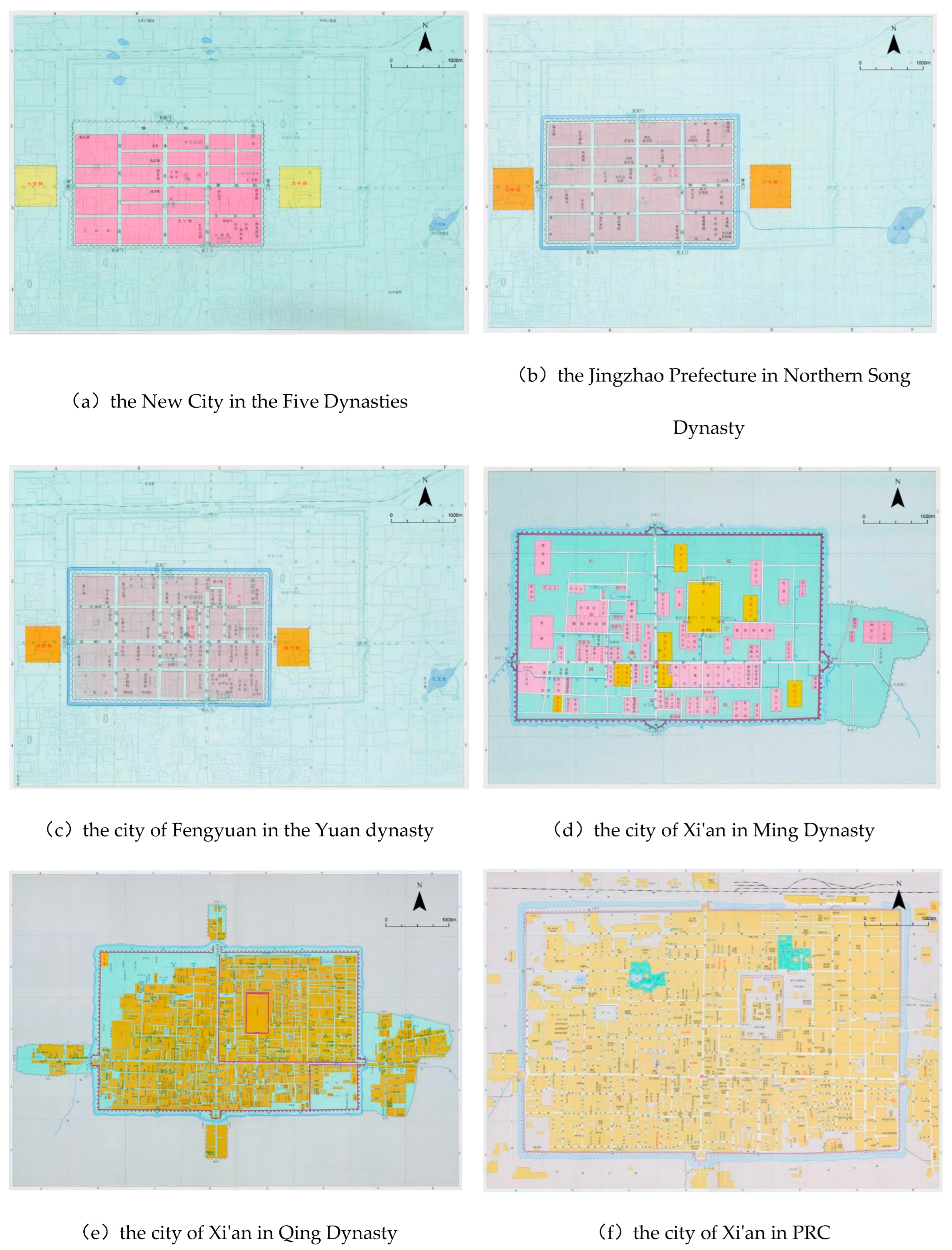
Figure 2.
GIS Research Network Visualization.
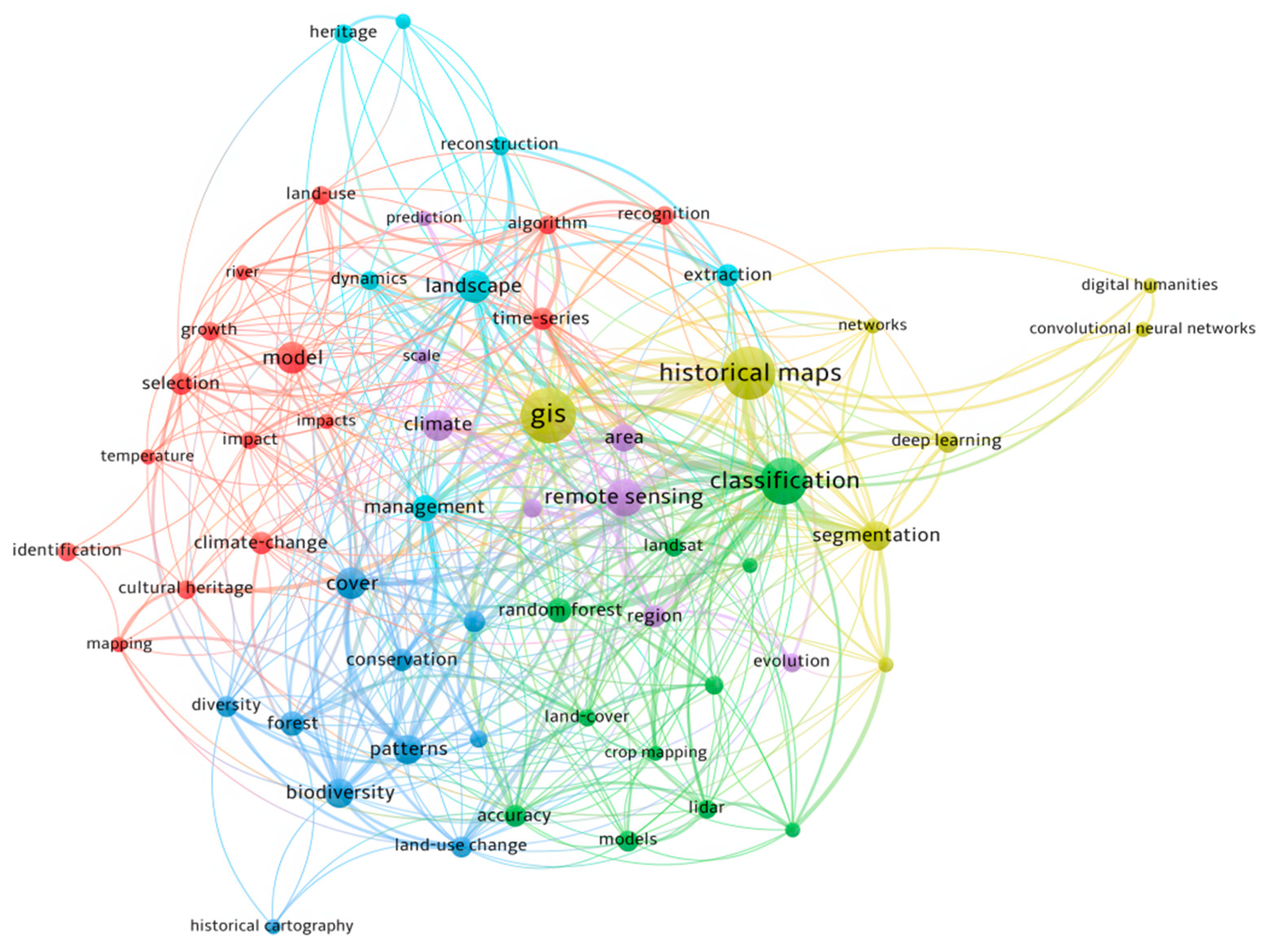
Figure 3.
The Evolution of Xi'an's Urban Spatial Structure.
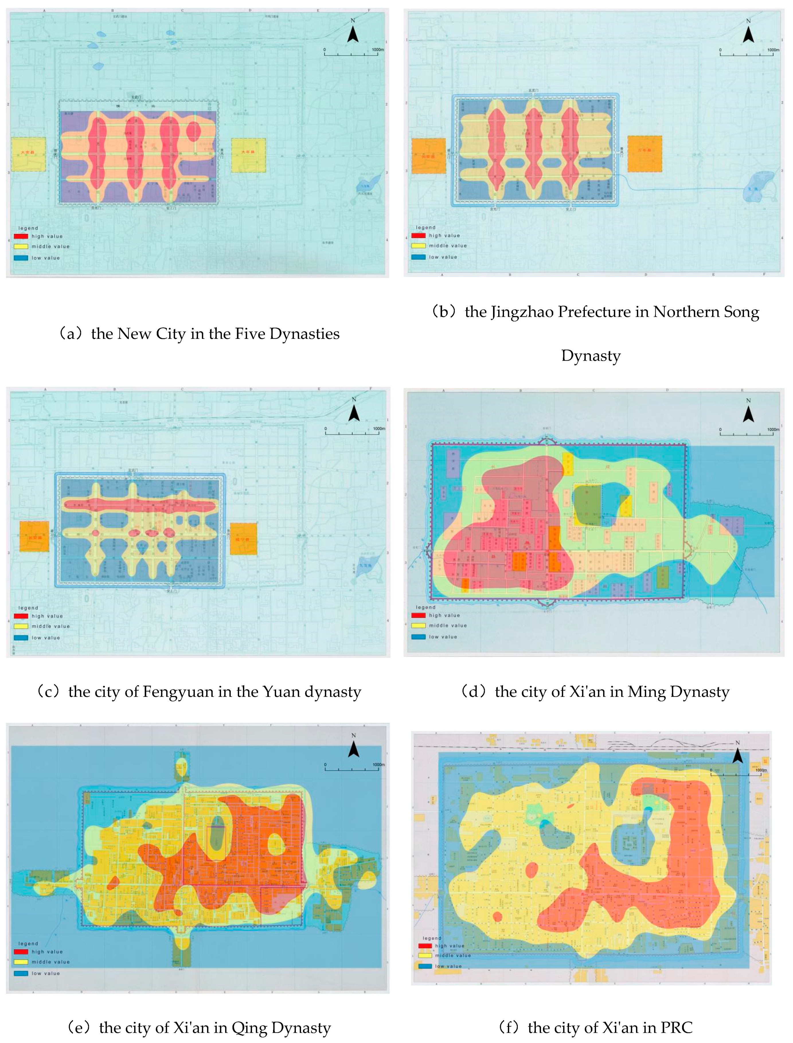

Table 1.
Overview of Major Research Directions in Historical GIS.
| No. | Research Direction in Historical GIS | Figures/Organizations | Research Outcomes or Methods | Challenges | Type |
|---|---|---|---|---|---|
| 1 | Digitization of Historical Maps[32] | Spence (University of Portsmouth), Xu Zhihong (Fudan University), GBHGIS | GBHGIS, CHGIS, Digital Archives | Difficulties in digitizing numerous historical sites, variations in map quality | Digitization, storage, management, and analysis of historical maps |
| 2 | Historical Geographic Information Systems[33] | American Geographical Society, Fudan University, University of Portsmouth | U.S. National Historical GIS, Irish Famine Atlas, Chrono-Spatial Framework of Chinese Civilization | Standardizing platforms across regions; database infrastructure for high-traffic access | Development and implementation of HGIS platforms |
| 3 | Historical Geographic Data Models[34] | Gail Langran, Griffiths (University of Portsmouth), Xu Zhihong (Fudan University) | Tripod Spatial Historical Data Model | High programming skills required for historical map analysis | Data models to analyze spatial historical data |
| 4 | Spatial Analysis of Historical GIS Data[35] | Paul Longley (UCL), Ian Gregory (Lancaster University), Zhang Hai (Sun Yat-sen University) | Spatial regression, geostatistics, and geographic modeling | Lack of complex, model-based data for historical datasets | Spatial and statistical analysis of historical data |
| 5 | Visualization of Historical Geographic Data[36] | Sadahiro (University of Tokyo), Li Haiping (Fudan University) | Visualization of Tokyo Urban Historical Landscape, U.S. Glacier Evolution Simulations | Limited access to high-precision scanning, virtual reality (VR) technologiest | Visualization of spatial data using GIS |
Table 2.
Concepts and Formulas in Space Syntax.
| No. | Concept | Formula | Description |
|---|---|---|---|
| 1 | Connectivtiy | The number of connections between a space (x) and its adjacent spaces (y) | |
| 2 | Integration | The inverse of the average length of the shortest paths from a specific space (x) to all other spaces (y) | |
| 3 | Control Value | The degree to which a space (x) controls its adjacent spaces (y) relative to other spaces (z) |
Disclaimer/Publisher’s Note: The statements, opinions and data contained in all publications are solely those of the individual author(s) and contributor(s) and not of MDPI and/or the editor(s). MDPI and/or the editor(s) disclaim responsibility for any injury to people or property resulting from any ideas, methods, instructions or products referred to in the content. |
© 2024 by the authors. Licensee MDPI, Basel, Switzerland. This article is an open access article distributed under the terms and conditions of the Creative Commons Attribution (CC BY) license (http://creativecommons.org/licenses/by/4.0/).
Copyright: This open access article is published under a Creative Commons CC BY 4.0 license, which permit the free download, distribution, and reuse, provided that the author and preprint are cited in any reuse.


