

Submitted:
21 September 2024
Posted:
23 September 2024
You are already at the latest version
Abstract
Historical maps possess significant theoretical and practical value in fields such as historical geography and urban planning, making them essential tools for studying urban spatial structure. This study explores the evolution of Xi'an's urban spatial structure from the Five Dynasties (909 CE) to the late PRC period (1949 CE), using historical maps and Historical GIS (HGIS) methodologies. By integrating Space Syntax and Kernel Density Estimation (KDE) with data from The Historical Atlas of Xi'an, this research identifies key trends in the city's spatial transformation. Two distinct phases of development were observed: the simpler, centralized structure during the Five Dynasties, Northern Song, and Yuan periods, and a more complex, decentralized structure during the Ming, Qing, and PRC periods. These changes were influenced by a dynamic interplay of political, economic, cultural, and environmental factors, as well as the city's need to adapt to external military threats and internal socio-economic shifts. The study emphasizes the value of HGIS in analyzing urban historical geography and the potential it offers for both understanding past urban dynamics and informing contemporary urban planning and cultural heritage preservation efforts. The findings demonstrate how Xi'an's spatial evolution reflects broader trends in Chinese history and provides insights for future sustainable development.
Keywords:
Historical Maps
; GIS
; Xi'an
; Urban Spatial Structure
; Evolution
1. Introduction
In recent years, the "Spatial Turn" has gained prominence as a transformative theoretical movement within the humanities and social sciences[1,2,3]. This shift marks a departure from traditional research that focuses primarily on micro-level cultural elements, such as individual texts, events, or artifacts, and encourages scholars to broaden their scope to include spatial contexts that shape and are shaped by human activities. The "Spatial Turn" advocates for a comprehensive exploration of space as an essential dimension for understanding historical, social, cultural, and political phenomena[4]. This approach highlights the interconnectedness of various elements within a given space and emphasizes how spatial configurations influence social relations, power dynamics, and cultural developments. It underscores the idea that space is not merely a backdrop for human action but an active participant in shaping social and historical processes.
Within this framework, David J. Bodenhamer has been a key figure in advancing the integration of Geographic Information Systems (GIS) technology in historical research[5,6]. He argues that GIS provides a powerful tool for representing and analyzing the complexities of historical and cultural spaces. Bodenhamer introduces the concept of "Deep Maps," a methodological approach that goes beyond traditional mapping to encompass multiple layers of information, including physical geography, social interactions, cultural narratives, and historical changes over time[7,8,9]. "Deep Maps" aim to create a more immersive and comprehensive understanding of a given space, integrating quantitative data with qualitative insights to capture the richness and diversity of human experiences within that space[10]. This concept aligns well with the goals of the "Spatial Turn" by providing a dynamic, multi-dimensional perspective that can be adapted to a wide range of historical and social research questions.
The introduction of historical GIS (HGIS) technology has fundamentally changed the way scholars approach urban history research[11]. It offers a set of tools and methods that allow for the visualization and analysis of spatial data at a level of detail and accuracy that was previously unattainable. By combining historical maps with modern GIS techniques, researchers can trace the evolution of urban spatial structures over time, analyze patterns of growth and decline, and identify the socio-economic, cultural, and political factors that have influenced urban development[12,13]. This technology enables scholars to reconstruct historical urban environments in a way that is both scientifically rigorous and accessible, allowing for a more nuanced understanding of how cities have evolved. Such insights are invaluable for urban planners, historians, geographers, and policymakers who seek to balance the preservation of cultural heritage with contemporary urban development.
As a critical data source for Historical Geographic Information Systems, historical maps have become indispensable in this field of study[14]. They provide a wealth of information about past landscapes, urban layouts, infrastructure, land use, and environmental changes[15]. When integrated with GIS technology, these maps can be used to create detailed spatial analyses that reveal long-term trends in urban development, such as changes in population density, the spread of different land uses, or the impact of socio-political events on urban morphology. This capability opens up new avenues for interdisciplinary research that connects historical geography with sociology, anthropology, archaeology, and other fields[16].
Looking forward, the role of historical maps in research is expected to become even more significant. As GIS technology continues to evolve, offering more advanced spatial analysis tools and greater accessibility, the potential for integrating historical maps into broader studies of urbanization, cultural landscapes, and regional development will expand[17]. These maps will not only serve as a foundation for historical inquiry but also as a bridge to future-oriented research that seeks to understand how past spatial arrangements inform present and future urban dynamics. Thus, the use of historical maps and GIS technology is poised to become a cornerstone of innovative research methodologies in both the humanities and social sciences, providing a richer, more integrated understanding of space and time.
Historical maps provide an invisible layer of knowledge that is fundamental for revealing the patterns of historical geographical development and transformation[18]. The maps, often created for practical, administrative, or strategic purposes in their time, encapsulate not only physical landscapes but also the socio-political and cultural contexts of different eras. From a spatiotemporal information perspective, historical maps offer scholars a unique, multi-dimensional lens to examine the historical changes in geographical elements over time[19,20,21]. They enable researchers to understand how cities, regions, and landscapes evolved under the influence of various factors, such as political regimes, economic activities, and social dynamics. As such, historical maps serve as essential carriers of cultural, political, economic, and even social ideologies[22,23], offering insights into the values, priorities, and knowledge systems of the societies that produced them.
Moreover, historical maps have gained renewed significance in the era of modern technology, becoming valuable resources for integrating cutting-edge methodologies with humanities research. With the advent of Geographic Information System (GIS) technology, the study of historical maps has evolved beyond mere visual inspection to involve sophisticated spatial analyses and quantitative methods[24]. Through GIS, researchers can digitize historical maps, align them with contemporary geographical data, and apply a range of spatial analyses, such as spatial interpolation, density analysis, and spatial auto-correlation[25]. These methods allow for a more in-depth exploration of urban growth patterns, changes in land use, and environmental transformations. Such technological integration not only improves the precision of historical research but also expands its depth and breadth, enabling more nuanced interpretations of past landscapes and societies[26].
In this context, historical maps have emerged as an indispensable research material, particularly for cities with a rich history and deep cultural heritage. These maps not only document the physical changes in urban form and land use over time but also reflect the shifting social, economic, and political landscapes that shaped the city's development[27]. For cities like Xi'an, where history is layered and complex, systematic analysis and study of historical maps are crucial. Such studies allow researchers to unravel the intricate processes that have driven the city's evolution across different historical epochs. Moreover, these analyses can generate data-driven insights and recommendations on how to better preserve and manage these historical and cultural assets. By leveraging historical experience and modern data analysis, scholars can provide actionable strategies for heritage conservation, urban planning, and sustainable development[28,29]. As one of the most important historical cities in China, Xi'an stands as a testament to the nation's rich and diverse history. With a civilization history spanning 5,000 years, a city-building history of 3,000 years, and a history of serving as a capital for over 1,000 years, Xi'an is a living archive of Chinese history(Figure 1).
It is not only one of the seven ancient capitals of China but also recognized as a national-level historical and cultural city, renowned for its abundance of cultural relics and deep historical memory. Since 2023, Xi'an has gained significant exposure and popularity as a leading tourist destination in China, drawing millions of visitors to explore its ancient wonders[30]. However, from a historical and cultural perspective, such popularity is transient. The true value of a historical city lies in its ability to retain its authenticity and integrity through time. Thus, a profound exploration of the city's historical development and an adherence to the laws governing urban evolution are essential to respecting and preserving Xi'an's historical legacy[31]. Based on the comprehensive data presented in The Historical Atlas of Xi'an by Shi Nianhai, the preliminary study uses a robust set of indicators—including construction levels, city area, building types, and landscape environment—to create a statistical chart of Xi'an's urban development spanning 6,000 years[32]. This chart provides a visual representation of how Xi'an's spatial and urban dynamics have changed over millennia. It reveals a significant pattern of decline followed by a rebound in development, particularly noticeable since the Five Dynasties period (907-960 AD). This cyclical pattern of rise, fall, and recovery highlights the resilience of Xi'an and serves as a crucial foundation for this study, as it offers critical insights into the forces that have shaped the city's historical trajectory and informs future strategies for urban conservation and development(Figure 2).
2. Literature Review
2.1. Historical Maps
The study of historical maps has its roots in the fields of cartography and historical geography, where early research primarily focused on the production, use, and interpretation of maps created in different historical periods[33]. Traditional scholarship often centered on understanding the cartographic techniques, symbolism, and intent behind these maps, as well as their role in colonial expansion, state-building, and navigation[34]. Early works by historians and geographers challenged the perception of maps as purely scientific documents, arguing instead that maps are also social constructs that embody the power dynamics and ideological contexts of their creators[35].
By the late 20th century, scholars began to increasingly recognize the potential of historical maps as dynamic sources of spatial data that could provide insights into historical processes such as urban growth, environmental change, and cultural transformation[36,37]. This shift coincided with the "Spatial Turn" in the humanities and social sciences, which emphasized the importance of space and spatial relationships in understanding human behavior and societal development. Researchers began to explore historical maps not only as static artifacts but also as dynamic records that could be analyzed quantitatively to reveal patterns of change over time[38].
The advent of GIS and digital tools has revolutionized the study of historical maps, leading to the emergence of Historical GIS (HGIS) as a powerful interdisciplinary field[39,40,41,42]. HGIS enables researchers to digitize, georeference, and integrate historical maps into spatial databases, allowing for sophisticated spatial analyses that were previously unattainable. Scholars can now overlay historical maps with contemporary spatial data, perform spatial analyses such as spatial interpolation, kernel density estimation, and spatial autocorrelation, and visualize changes in landscapes, urban form, and human-environment interactions across time.
Significant projects like the China Historical GIS (CHGIS), the Great Britain Historical GIS (GBHGIS), and the Digital Atlas of Roman and Medieval Civilizations (DARMC) have set important precedents in the integration of historical maps with GIS technology. These projects have facilitated new forms of inquiry in history, archaeology, and urban studies, enabling scholars to reconstruct historical landscapes, analyze historical settlement patterns, and examine the socio-economic and cultural dynamics that shaped historical developments. For instance, the GBHGIS project has been used to study the historical geography of Britain, mapping demographic changes, land use, and social indicators over several centuries(Figure 3).
Digital humanities have further expanded the scope of historical map studies by integrating digital mapping techniques with computational methods[43]. Projects like Mapping the Republic of Letters and Visualizing Venice utilize historical maps and digital visualization tools to analyze the networks of intellectual exchange in the early modern period or to reconstruct the architectural and urban transformations of Renaissance Venice. Such interdisciplinary projects demonstrate the potential of historical maps to serve as a bridge between the humanities and computational sciences, fostering collaboration between historians, geographers, computer scientists, and data visualization experts.
Despite the advancements in historical map studies, several challenges remain. One major issue is the quality and accuracy of digitized historical maps. Geo-referencing historical maps often involves dealing with distortions, incomplete data, and inconsistent scales, which can affect the reliability of spatial analyses. Additionally, the integration of historical maps with modern GIS data requires careful attention to temporal and contextual differences to avoid anachronisms and misinterpretations.
2.2. Historical GIS
Historical GIS(HGIS) have emerged as a trans-formative approach in the study of history, geography, archaeology, and other social sciences. By integrating GIS technology with historical data, HGIS allows researchers to analyze, visualize, and interpret spatial and temporal patterns of historical phenomena in ways that were previously unimaginable. This interdisciplinary field combines the rigor of historical scholarship with the spatial analytical power of GIS, enabling new insights into historical processes, urban development, and cultural transformations[44].
The concept of HGIS began to take shape in the late 20th century, as scholars in history and geography started to recognize the potential of GIS technology to handle spatial data from the past. Unlike traditional GIS applications that focus on contemporary spatial data, HGIS involves the digitization, geo-referencing, and integration of historical maps, documents, and other archival sources into GIS platforms. This allows for the mapping and analysis of historical events, population changes, land use transformations, and other phenomena over time.
One of the key innovations of HGIS is its ability to handle temporal and spatial data simultaneously, allowing for the analysis of change over time within a specific geographical context[45]. This capability is particularly valuable for historians, archaeologists, and geographers who are interested in understanding long-term processes such as urban growth, migration, economic development, and environmental change. Methodologically, HGIS combines traditional GIS tools—such as spatial analysis, network analysis, and spatial statistics—with historical methods, including archival research, cartographic analysis, and textual interpretation[46]. Researchers can overlay historical maps with modern spatial data, perform spatial-temporal analyses, and create dynamic visualizations that illustrate historical phenomena with a level of precision and clarity that was previously unattainable(Table 1).
Recent developments in HGIS have also seen the integration of advanced technologies like machine learning, artificial intelligence, and big data analytics[52]. For instance, machine learning algorithms can be used to detect patterns in large historical datasets, while AI techniques can help in the automated georeferencing and digitization of historical maps[53,54,55,56]. These technologies enable more sophisticated analyses and open up new possibilities for exploring complex historical questions, such as the diffusion of cultural practices, the impact of climate change on historical societies, and the spatial organization of ancient economies(Figure 4).
The application of HGIS has significantly broadened the scope of historical research, offering new ways to approach traditional topics and opening up new areas of inquiry. HGIS has been widely used to study the development of cities and regions over time. By mapping historical data on urban infrastructure, population distribution, and economic activity, scholars can analyze patterns of urban growth, spatial inequalities, and the impact of policy decisions on city development. Projects like Mapping Early Modern London and Visualizing Venice utilize HGIS to reconstruct the urban landscapes of historical cities, providing insights into their social, economic, and cultural evolution.
Looking ahead, the future of HGIS lies in its continued integration with emerging technologies and interdisciplinary approaches. The use of big data analytics, virtual reality, and augmented reality has the potential to create more immersive and interactive historical experiences. Moreover, the development of open-access HGIS platforms and collaborative digital projects can facilitate knowledge sharing and foster greater collaboration among scholars, practitioners, and the public.
2.3. Evolution of Xi'an's Urban Spatial Structure
The study of the evolution of Xi'an's urban spatial structure has long been a focus for historians, geographers, and urban scholars in Western China, resulting in the development of distinct research schools and paradigms. Two of the most notable institutions contributing to this field are Shaanxi Normal University and Xi'an University of Architecture and Technology.
Professor Shi Hongshuai from the Northwest Environmental Development Center at Shaanxi Normal University authored the book The Urban Geography of Xi'an During the Ming and Qing Dynasties, which provides a comprehensive study of the historical urban geography of Xi'an during this period[57]. The book focuses primarily on the spatial issues of Xi'an Prefecture, analyzing the evolution of the spatial layout and the structural relationships between various functional areas within the city. Specific regions, such as the Mancheng (Manchu Garrison), Muslim neighborhoods, and Eight Banners areas, are discussed in great detail. However, while the book offers a rich synthesis of historical data, it lacks a thorough examination of the dynamic aspects of urban spatial structure, particularly how these spaces evolved over time and interacted with broader urban trends.
Professor Ren Yunyin from Xi'an University of Architecture and Technology wrote Transformation and Reconstruction: The Evolution of Urban Spatial Structure in Modern Xi'an, an important work that approaches the evolution of Xi'an's urban spatial structure from the perspectives of historical urban geography and urban historical planning[58]. By employing macro, meso, and micro-level research methodologies, Professor Ren's book reconstructs sectional views of the city's spatial development across different historical stages. Through the analysis of layered historical urban data, this work reveals patterns and characteristics of Xi'an's spatial evolution. In particular, her research on the spatial structure of Xi'an Prefecture during the late Qing period is noteworthy for its use of "dual evidence"—combining historical documents and maps to visualize spatial patterns. This method provides valuable insights and serves as an important reference for subsequent studies on the evolution of Xi'an's urban form.
Moreover, Professor Ren's research represents a significant contribution to the understanding of the city's transformation from a historical and spatial perspective. Her approach, which integrates both historical literature and cartographic sources, helps to visualize the changes in Xi'an's urban structure over time. This combination of historical data sources with modern analytical techniques not only enhances the accuracy of spatial reconstructions but also enriches our understanding of how historical, political, and cultural factors shaped the development of Xi'an. Expanding upon these foundational works, future studies could benefit from incorporating GIS technology and more dynamic spatial analysis techniques to explore how Xi'an's urban structure has changed over time. By layering historical maps and contemporary spatial data, scholars can better understand the factors driving urban evolution and the implications for urban planning and heritage conservation in Xi'an today. In current research, especially with the advent of the "spatial turn" and the growing field of digital humanities and HGIS studies, information and computer technologies are increasingly being integrated into traditional historical research. These advancements, combined with the use of historical maps as effective tools, allow researchers to reconstruct historical urban spatial structures and forms, ultimately revealing the development patterns of historical cities. However, when it comes to Xi'an—one of China's most significant historical cities—it is regrettable that the application of modern technologies to study the evolution of its urban spatial structure has been relatively rare. Much of the existing research still relies heavily on traditional historical methodologies, such as term interpretation, textual analysis, and conventional urban land use classification, which fail to adequately explore and explain the city's spatial structure from both temporal and spatial dimensions. This lack of advanced, multi-dimensional analysis makes it difficult for such studies to offer meaningful guidance for contemporary urban planning.
This study seeks to fill that gap by utilizing historical maps and GIS technology to trace the evolution of Xi'an's urban spatial structure from the Five Dynasties period (907–960 CE) through the establishment of the People's Republic of China. By examining the transformations in Xi'an's urban form across this thousand-year span, the research aims to uncover the underlying forces driving urban change from ancient to modern times. This long-term analysis is crucial not only for understanding the historical processes that shaped Chinese cities but also for providing insights into Xi'an's specific urban trajectory.
For Xi'an, this research holds particular importance. It allows us to trace the origins of the city's current spatial structure, understand why Xi'an has developed its present characteristics, and consider how these historical patterns can inform future urban planning[59]. This study provides a foundation for examining how Xi'an's urban structure evolved and offers valuable insights into key areas such as cultural heritage preservation, urban tourism development, and urban renewal. Understanding how the city's spatial form has changed over time enables policymakers, urban planners, and scholars to make informed decisions about its future development, ensuring that modern growth respects and integrates its rich historical and cultural legacy. Furthermore, by adopting advanced technologies such as GIS, this study is positioned at the intersection of past and present, providing both a detailed retrospective of Xi'an's urban evolution and forward-looking recommendations for sustainable urban planning. The study's multi-temporal approach allows for a more dynamic analysis of how political, economic, and social factors influenced Xi'an's urban growth and spatial reorganization over the centuries. This not only enriches our understanding of the historical forces at play but also offers actionable insights into how to manage future urban challenges while preserving the city's unique historical identity. In the context of Xi'an, such an approach is crucial for fostering urban development that balances modern needs with the protection of its invaluable cultural heritage.
By using historical maps in conjunction with GIS technology, this research adds a much-needed spatial and temporal dimension to the study of Xi'an's urban structure. It provides a framework through which the city's urban form can be better understood, not just as a static historical artifact, but as a living, evolving space that continues to be shaped by both its past and present. This dual focus on historical evolution and contemporary application makes the study especially relevant for those seeking to preserve Xi'an's heritage while guiding its future urban development.
3. Data Sources and Methods
3.1. Data Sources
One of the key data sources for this study is the book The Historical Atlas of Xi'an, edited by the renowned scholar Shi Nianhai. This atlas is an outstanding work of regional historical cartography and serves as a crucial bridge between the past and the present, as well as between empirical research and theoretical analysis. The atlas holds immense academic value, providing a detailed spatial historical record of Xi'an that covers various aspects of the city's urban structure, street layout, and building distribution across different historical periods. These maps are invaluable for studying the socio-economic and cultural transformations that Xi'an underwent over the centuries. By offering such precise empirical data, The Historical Atlas of Xi'an allows researchers to explore the intricate relationships between geography, politics, and society that shaped the city's evolution.
What makes this atlas particularly important is not only its extensive scope but also the rigorous academic methodology employed in its compilation. Shi Nianhai and his team ensured that the maps were based on solid historical evidence, combining documentary sources with field surveys to create accurate representations of Xi'an's historical landscape. As a result, the atlas has become a reliable data source for scholars interested in studying the spatial and urban history of Xi'an. It provides a trustworthy foundation for analyzing changes in the city's spatial structure and the underlying forces driving those changes.
The value of this atlas is further enhanced when combined with modern analytical tools, such as HGIS. By digitizing the maps and integrating them with Geographic Information Systems, researchers can perform sophisticated spatial analyses that were previously impossible with traditional cartography alone. For instance, GIS technology allows for the overlaying of historical maps with contemporary spatial data, enabling a more dynamic exploration of how Xi'an's urban form has changed over time. This integration of traditional historical mapping with cutting-edge digital tools enables a more nuanced understanding of the city's urban development.
When used in conjunction with GIS technology, the value of The Historical Atlas of Xi'an becomes even more significant. The digitization of these historical maps allows for temporal analysis, where researchers can track the development of specific neighborhoods or the expansion of the city over time. Furthermore, GIS enables a more precise analysis of spatial relationships within the city, such as the proximity of religious buildings to marketplaces, or the location of administrative centers in relation to residential areas. This level of analysis provides not only a clearer picture of Xi'an's historical urban structure but also offers insights into the factors that influenced urban planning decisions in different historical periods.
This study draws extensively on data from The Historical Atlas of Xi'an and seeks to ensure that both temporal and spatial continuity are maintained throughout the analysis. To achieve this, we focus on selecting areas that have played a pivotal role in shaping the modern spatial structure of Xi'an, particularly those with long-term historical significance. Xi'an, known historically as Chang'an, has seen multiple phases of construction, destruction, and reconstruction over centuries, making it a prime example of a city whose urban form is deeply influenced by its historical legacy.
Historically, one of the most significant developments occurred during the first year of the Tianyou reign (902 CE) under Emperor Zhaozong of the Tang Dynasty. During this period, the Jiedushi (military governor) Han Jian undertook a major reconstruction project. He rebuilt the city on the remnants of the original imperial city, shifting its focus to a "New City" that would serve as the administrative and military center. This reconstruction formed the foundations of the urban spatial structure that would influence Xi'an's development for centuries. This significant rebuilding effort marked a key transition point in the city's history, as it set the stage for future expansions and modifications that shaped its spatial configuration.
Following the Tang Dynasty, the Song, Yuan, and Jin dynasties did not undertake major renovations to the city. Instead, they largely maintained the spatial layout established during the Tang period. Despite their relative inactivity in terms of urban reconstruction, the city still functioned as an important regional center. Its spatial organization remained largely intact, although shifts in political power and regional importance influenced the functionality of different areas within the city. However, it wasn't until the Ming Dynasty that Xi'an underwent substantial changes in its urban form. The Ming Dynasty represents a critical phase in the city's urban evolution, particularly with the construction of the Guocheng (outer city), which significantly expanded the city's physical boundaries. This construction included fortifications that extended beyond the inner core, creating the layout that would become the foundation for modern Xi'an. The building of the outer city walls and the expansion of the city's administrative and residential areas reflect the Ming Dynasty's efforts to reinforce the city's role as a regional military and administrative center. These developments also contributed to the establishment of the city's current urban layout, most notably the portions of Xi'an that remain within the boundaries of the present city walls.
The city walls, as they exist today, encapsulate much of Xi'an's historical trajectory, serving as both a physical boundary and a cultural symbol of the city's long-standing significance. Over time, the spaces within these walls have been continuously reshaped by social, political, and economic forces, making Xi'an a dynamic urban environment that evolved through a unique blend of historical continuity and modern adaptations.
Given the complex history of Xi'an's urban development, this study selects key historical maps that span from the Five Dynasties period (909 CE) to the People's Republic of China (1949 CE). These timeframes are chosen for their representative significance in illustrating the evolution of the city's spatial structure. By focusing on these critical periods, we can trace the major shifts in urban layout, including the expansion of residential areas, the redistribution of administrative functions, and the development of infrastructure. Each of these factors contributed to the transformation of Xi'an from a dynastic capital into a modern urban center.
Moreover, examining historical maps from these periods allows for a deeper exploration of the forces that shaped Xi'an's urban growth. The maps provide valuable insights into how the city's spatial organization evolved in response to changing political regimes, economic conditions, and cultural influences. Through the use of GIS technology, these historical maps can be overlaid with modern spatial data, enabling a comparative analysis of how past urban layouts continue to influence the present-day city. This approach also facilitates a better understanding of the enduring legacy of historical urban planning decisions and their long-term impact on contemporary urban development.
In conclusion, by selecting these representative historical periods—from the construction of the "New City" in the Five Dynasties period to the PRC era—this study aims to offer a comprehensive analysis of Xi'an's urban spatial evolution. These historical maps serve as a window into the past, revealing not only the physical transformations of the city but also the socio-political and economic dynamics that drove those changes. The findings from this analysis will provide valuable insights into the city's historical development and inform future urban planning and heritage conservation efforts in Xi'an (Figure 5).
There are three main reasons for selecting Xi'an during these six periods. First, these six dynasties hold significant historical representativeness in Chinese history. Over the course of more than a thousand years, from the Five Dynasties to the founding of the People's Republic of China, China experienced periods of division, unification, and fragmentation, followed by eventual reunification. These historical processes left an imprint on the spatial structure of cities, providing valuable insights into the broader historical context of China. Second, Xi'an holds regional significance. Although Xi'an was downgraded from the capital of the empire to a regional center after the An-Shi Rebellion, its long-standing role in frontier construction, due to its proximity to the Western regions and governance over frontier territories, made it the foremost city in China's western region. Therefore, studying Xi'an's urban spatial structure is representative of the broader urban development in western China. Third, the availability of source materials is a key factor. Research in historical geography heavily relies on historical maps, but due to various reasons, only a limited number of historical maps have survived. In each historical period, cities are often represented by a single map. Hence, these six historical maps were selected as the subjects of this study.
3.2. Methods
This study primarily employs Space Syntax and Kernel Density Estimation (KDE) as its core analytical methods, both of which are widely recognized for their ability to quantitatively assess spatial structures and patterns within urban environments. These methods provide a comprehensive approach to understanding the intricate relationship between physical space and human activity, offering both theoretical and practical insights that are crucial for analyzing historical urban development.
(1) Space Syntax
Space Syntax is a powerful and well-established theoretical and methodological framework designed for the study and analysis of spatial systems, with a particular focus on architectural and urban environments[60]. Developed in the late 1970s by Bill Hillier and Julienne Hanson at University College London (UCL), Space Syntax is rooted in the idea that the configuration of space directly influences the social, economic, and cultural dynamics of a given environment[61]. This method aims to quantify spatial relationships in such a way that researchers can systematically explore the connections between the built environment and social behaviors, including how people move through spaces, interact within them, and form social connections as a result of their spatial experiences(Table 2).
Space Syntax analyzes spatial layouts by breaking them into elements like streets or open spaces, representing these as networks of lines (axes) that reflect movement routes and visibility. It measures key spatial properties: connectivity (how many spaces link to a specific space), integration (ease of access from other spaces), and control value (a space’s influence over its neighbors). These metrics help quantify city layouts, predicting movement patterns and social behavior. Tools like Depthmap and Axwoman simulate spatial configurations, calculate Space Syntax metrics, and generate visual maps to highlight central or peripheral areas, aiding both local and citywide spatial analyses.The results generated by Space Syntax software are not just quantitative metrics but are deeply interpretable through the lens of urban theory. For instance, the idea that a well-integrated street might foster higher levels of foot traffic and social interaction has profound implications for both historical and contemporary urban design. In historical studies, these metrics can help explain why certain areas of ancient or medieval cities were more vibrant than others, or how shifts in spatial structure over time corresponded to changes in political, economic, or social dynamics. For modern urban planning, understanding the spatial organization of a city can lead to improved designs that promote better social interaction, more efficient transportation networks, or enhanced accessibility to essential services.
In summary, Space Syntax offers a comprehensive and rigorous framework for exploring how the spatial configuration of environments influences human behavior. By leveraging specialized software to quantify spatial relationships and simulate movement patterns, this method allows researchers to generate insights into the social dynamics of both historical and contemporary urban spaces. Its ability to bridge the gap between spatial theory and practical urban analysis makes it an invaluable tool in both academic research and real-world urban planning.
(2) Kernel Density Estimation (KDE)
Kernel Density Estimation (KDE) is a versatile and widely used non-parametric method for estimating the probability density function (PDF) of a random variable[62]. Unlike parametric methods, KDE does not rely on specific distribution assumptions, making it versatile for various applications where the data distribution is unknown or complex. It is valuable for both one-dimensional and multi-dimensional data, offering a smooth estimate that reveals clusters, peaks, or gaps in the dataset. KDE is commonly used for data visualization, producing a continuous curve or surface that highlights areas of high or low data concentration, providing a more refined and detailed representation compared to histogram-based methods, which can be limited by binning issues. The one-dimensional KDE formula is typically expressed as:
Where:
- f(x) is the estimated density at point x,
- n is the number of sample points,
- h is the bandwidth, which controls the smoothness of the density estimate,
- K(.) is the kernel function, which determines the shape of the curve around each data point,
- xi are the individual sample points in the dataset.
In the context of KDE, the choice of the kernel function and bandwidth parameter h plays a crucial role in determining the quality of the density estimate. The kernel function K(.) is often chosen to be a Gaussian (normal) distribution, but other kernel functions, such as the Epanechnikov or uniform kernels, can also be used depending on the specific application. The bandwidth parameter h controls how smooth or detailed the resulting density estimate will be. A larger bandwidth will produce a smoother density curve, potentially oversmoothing important details, while a smaller bandwidth will produce a more detailed curve, but may result in overfitting or noise.
In this study, KDE is applied to historical urban spatial data to explore and visualize the density distribution of various elements in the urban environment. Specifically, the spatial data derived from the Space Syntax analysis is integrated with KDE to generate density maps that highlight key patterns in the historical development of urban spaces. By combining these two methods, the study provides a more comprehensive view of the spatial dynamics at play in historical urban environments. The KDE-generated maps offer valuable insights into the spatial concentration of important features, such as buildings, streets, or public spaces, allowing researchers to identify areas of high density or historical significance.
In conclusion, Kernel Density Estimation is a powerful and flexible tool for estimating probability density functions and visualizing data distributions. Its ability to generate smooth, continuous representations of data makes it ideal for revealing underlying patterns and trends, particularly in spatial data analysis. In this study, KDE is used in conjunction with Space Syntax to produce detailed maps of historical urban spaces, providing a deeper understanding of how the spatial structure of cities evolved over time. By applying modern computational techniques to historical data, this study offers new insights into the historical development of urban environments and the factors that shaped them.
4. Discussion
The analysis of the six historical maps, followed by visualization, yielded the results shown in Figure 6. From the spatial structure maps, the process of changes in Xi'an's urban spatial structure is clearly visible. The following section will explore the characteristics and influencing factors of the spatiotemporal evolution of the urban structure from both a typological and morphologyical perspective.
4.1. Evolution of Xi'an's Urban Spatial Structure Types
The evolution of Xi'an's urban spatial structure over the 1,040-year period, from the establishment of the New City during the Five Dynasties (909 CE) to the late PRC period (1949 CE), demonstrates significant changes that can be divided into two major phases. The first phase encompasses the Five Dynasties, Northern Song, and Yuan periods, characterized by a simpler spatial configuration that is typical of traditional feudal cities. The second phase, covering the Ming, Qing, and PRC periods, exhibits features of more modern urban development, which laid the foundation for the current spatial structure of Xi'an. This dual-phase evolution reflects broader socio-political and economic shifts across these centuries, each leaving its own distinctive mark on the city's layout.
During the Five Dynasties, Northern Song, and Yuan periods, Xi'an's urban form was distinguished by its simplicity and linearity. The city's spatial structure was primarily street-focused, with major streets, marketplaces, and public spaces concentrated around a few key axes. This straightforward layout was largely influenced by the political and economic realities of the time. In these periods, the Chinese empire was fragmented or undergoing significant transitions, which meant that cities like Xi'an, located on the empire's northwestern frontier, often became the focal point of conflicts and exchanges between different ethnic groups and powers. As a result, Xi'an served as both a battleground and a center for ethnic integration, and the central government's investment in developing this region was relatively limited. This underinvestment in urban development translated into a simpler, more functional spatial structure, designed to prioritize the efficiency of administrative and military operations. The city was laid out in a manner that facilitated rapid deployment of resources and personnel, with a clear focus on the city's primary roads and key public spaces.
Furthermore, spatial kernel density analysis of Xi'an's historical maps from this era reveals that the city's major streets were highly integrated. This suggests that even though the spatial structure was relatively simple, the connectivity within the city was robust, allowing for smooth transportation and the flow of goods and people. This high degree of integration made it easier for residents to navigate the city, and the linear street layout reinforced the central role of specific corridors in the city's daily life. The compactness of the city also fostered more concentrated forms of social interaction, with marketplaces and public spaces serving as vital hubs of activity.
In contrast, during the Ming, Qing, and late PRC periods, Xi'an's spatial structure became markedly more complex and dispersed. Both the Ming and Qing dynasties were characterized by long periods of centralized unification, during which the political climate was relatively stable, and the economy thrived. Under these conditions, urban development in Xi'an became more diversified, with a growing emphasis on commerce, culture, and religion. The Ming dynasty, in particular, made significant investments in expanding the city's physical footprint, constructing new city walls, and establishing commercial centers, religious buildings, and cultural institutions. These developments contributed to a more intricate urban layout, where different types of land use coexisted and expanded beyond the traditional core of the city. This transition marked a shift from a more militaristic and administrative city to one that incorporated broader economic and social functions, reflecting the increased complexity of Chinese society during this period.
A major contributing factor to this shift in urban structure was the changing political and military landscape. Frequent border conflicts, such as those with the Mongols during the Ming dynasty, and internal strife, such as the Tumu Crisis, required Xi'an to strengthen its defenses. The construction of fortified city walls and other defensive measures reshaped the city's internal layout, making it more dispersed and less linear. The focus of urban development shifted from a single centralized core to multiple directions, as the city's spatial structure became more adaptable to both external threats and internal growth. This decentralized urban structure helped mitigate the risks of attacks on the city's central areas, ensuring that vital functions, such as commerce and governance, could continue even during times of crisis.
By the Qing dynasty, the weakening of the central government and the rise of local power structures further contributed to the complexity of Xi'an's spatial organization. The city became more fragmented as different districts evolved to serve distinct purposes, ranging from commerce and trade to military and residential uses. This diversification of functions within the urban space resulted in a more complex network of streets and public spaces, which no longer adhered strictly to the traditional, centralized grid system. Instead, new street patterns emerged that reflected the growing demands of an expanding urban population and the need for more flexible urban planning.
In the late PRC period, especially during and after the Second Sino-Japanese War and the Chinese Civil War, Xi'an's spatial structure became increasingly fragmented. The political and social upheavals of the time, combined with rapid urbanization and industrialization, led to the emergence of distinct commercial, industrial, and residential zones. These areas often developed independently of one another, forming relatively self-contained networks that were separate from the traditional city center. The spatial organization of the city became more complex as new economic activities, such as manufacturing and trade, expanded the city's footprint and introduced new layers of urban development. As a result, Xi'an's spatial structure became increasingly decentralized, with different types of spaces serving specialized roles within the urban fabric.
This transition to a more complex and dispersed urban layout also reflected broader changes in Chinese society during the late Qing and PRC periods, including the introduction of Western ideas and technologies, the rise of industrialization, and the increased importance of education and infrastructure. The city's new spatial organization allowed it to adapt to the demands of modernity while still retaining elements of its historical character. Over time, Xi'an's urban structure evolved into a hybrid of traditional and modern forms, combining historical spatial patterns with the functional requirements of a modern city.
In conclusion, the evolution of Xi'an's urban spatial structure from the Five Dynasties to the late PRC period illustrates a clear shift from simplicity and linearity to complexity and dispersion. This transformation reflects the broader political, economic, and social changes that occurred over this period, as Xi'an adapted to its changing role within China. The city's urban structure became increasingly sophisticated, incorporating diverse functions and adapting to new challenges while maintaining elements of its historical legacy.
4.2. Evolution of Xi'an's Urban Spatial Morphology
From the perspective of urban morphology, the evolution of Xi'an's spatial structure over the millennium between the Five Dynasties and the late PRC period demonstrates profound and notable shifts, with two clear spatial paradigms emerging across different historical periods. The first paradigm, present during the Five Dynasties, Northern Song, and Yuan periods, was characterized by a grid-like pattern of streets, forming a straightforward and simplistic urban grid. This form of urban organization was highly effective within the political, economic, and cultural contexts of those times, particularly when strong centralized governments and administrative systems demanded a clear, easily manageable spatial structure. The second paradigm, which emerged during the Ming, Qing, and PRC periods, saw the evolution of a much more complex and dispersed urban spatial structure, reflecting not only the changing demands of urban defense but also the growing diversification of urban functions in response to shifting political, economic, and social landscapes.
In the early period of Xi'an's development, spanning the Five Dynasties, Northern Song, and Yuan eras, the city's street axes followed a strict and organized grid-like configuration. This simplistic spatial arrangement mirrored the needs of a centralized government, which required order and clarity in the management of urban spaces. The grid structure, by its nature, facilitated centralized control, allowing authorities to oversee and regulate markets, religious institutions, and public facilities with relative ease. Inhabitants of the city also benefited from this organized structure, as it supported a concentrated and cohesive urban lifestyle, where key areas of social, economic, and religious activity were conveniently located in the city's core. These centralized hubs provided the foundation for economic and cultural activities to thrive, as they were easily accessible to the populace.
Furthermore, spatial kernel density analysis of this period reveals a relatively high degree of integration in Xi'an's urban network. This high level of connectivity between different parts of the city indicates that the urban fabric was well-suited to both daily life and broader social interactions. It allowed for the efficient movement of people, goods, and ideas, promoting economic prosperity and the exchange of cultural practices. The grid structure thus not only fulfilled the practical needs of governance but also fostered a vibrant urban environment where markets and public spaces played a crucial role in social cohesion.
However, there were subtle yet important distinctions between the grid structures of the Five Dynasties, Northern Song, and Yuan periods. In the Five Dynasties and Northern Song, the grid primarily followed a north-south orientation, reflecting the traditional Chinese cosmological and cultural preference for axial alignment along cardinal directions. In contrast, during the Yuan dynasty, the grid shifted to an east-west orientation, largely due to the influence of the Mongol rulers who had established the Yuan dynasty. The Mongols, as a nomadic people, preferred to reside, govern, and conduct trade in the northern parts of their cities, leading to the development of a northern-centered urban form. This shift in spatial orientation reflected not only the political dominance of the Mongols but also their cultural preferences and practices, which had a lasting impact on the urban layout of Xi'an during this period.
As Xi'an entered the Ming, Qing, and PRC periods, its spatial structure began to evolve significantly. The once clear and centralized grid of streets gave way to a more complex and dispersed model of urban organization. The street axes, which had previously followed strict radial or grid patterns, now began to branch out and intersect in more irregular ways, reflecting the increasingly intricate social, economic, and political landscapes of the time. This evolution was driven in part by the need for enhanced city defenses, particularly during the Ming and Qing dynasties, when China faced numerous external threats and internal conflicts. The construction of fortified city walls and other defensive structures contributed to the decentralization of the city's spatial form, as urban development expanded outward from the central core to peripheral areas, creating a more diversified urban landscape.
The more dispersed spatial structure of this later period also served a practical purpose, as it reduced the risks associated with concentrating key urban functions in a single location. In the event of an attack or natural disaster, having a more decentralized urban layout allowed the city to continue functioning, even if one area was compromised. This resilience was crucial during periods of conflict, such as the frequent border wars of the Ming dynasty and the internal strife of the late Qing and PRC periods. The construction of new city walls, defensive structures, and the expansion of key urban areas reflected the city's growing complexity and the increased need for both physical and functional diversity within its spatial organization.
In addition to its defensive needs, the diversification of Xi'an's urban functions during the Ming, Qing, and PRC periods played a significant role in shaping its spatial morphology. During this time, the city saw the rise of new industrial zones, educational institutions, and public parks, in addition to the traditional markets and religious centers that had dominated earlier periods. This diversification was a reflection of the broader social and economic changes occurring within China, as industrialization and modernization began to take hold. The spatial structure of Xi'an responded to these changes by becoming more varied and flexible, with different areas of the city serving specialized functions. The street axes, once primarily focused on connecting centralized hubs, now supported a wider range of activities, creating a more complex and interconnected urban network.
Spatial kernel density analysis of this later period reveals that while the integration of street axes decreased relative to the earlier grid structures, the flexibility and adaptability of the urban layout increased. This decreased connectivity, though it may have reduced the efficiency of certain types of movement within the city, allowed for greater social and economic diversity, as different parts of the city developed distinct identities and purposes. For example, the emergence of industrial areas, residential neighborhoods, and cultural institutions reflected the growing complexity of urban life, as well as the need for a spatial structure that could accommodate a wider range of activities.
This evolution in spatial morphology is also linked to broader political changes, particularly during the Qing dynasty, when the construction of the Manchu garrison in Xi'an intensified class divisions and concentrated the city's resources in specific areas. The establishment of this garrison not only altered the physical layout of the city but also had a lasting impact on its social structure, influencing the way different groups interacted within the urban environment. These political factors, which played a central role in shaping Xi'an's spatial morphology throughout its history, highlight the importance of understanding the relationship between political power and urban form in the study of historical cities.
In conclusion, the evolution of Xi'an's spatial morphology from the Five Dynasties to the late PRC period reflects broader trends in social, economic, and political development. The city's transformation from a simple, centralized grid to a more complex and dispersed urban form mirrors the increasing complexity of Chinese society during this time. This morphological evolution not only influenced the daily lives and social interactions of Xi'an's residents but also provides valuable insights into the internal logic and patterns that shaped historical urban spatial structures. Understanding these patterns is crucial for contemporary urban planning and historical restoration efforts, as they offer important lessons on how to balance the demands of modern development with the preservation of historical integrity.
4.3. Influencing Factors of Xi'an's Urban Spatial Structure
The evolution of Xi'an's urban spatial structure from the Five Dynasties to the late PRC period was shaped by a multifaceted and multi-dimensional array of influencing factors, with different combinations of these factors taking precedence at various stages in history. These factors—political, economic, cultural, religious, geographical, and environmental—interacted in complex ways, each contributing to the city's urban form and its evolution over time.
First and foremost, political factors played a pivotal role throughout Xi'an's urban development. During the Five Dynasties, Northern Song, and Yuan periods, political instability, border wars, and internal conflicts not only shaped the city's defensive needs but also heightened the tension between central and local authorities. These conflicts and power struggles often influenced urban planning decisions, leading to the creation of a more straightforward urban spatial structure. The simplicity of the spatial layout, with its linear street axes and centralized hubs, can be seen as a direct response to the need for efficient control and defense. Xi'an's role as a northwestern frontier city meant it was a key site for managing ethnic conflicts, military campaigns, and administrative tasks. In particular, the Yuan dynasty's political unification and outward expansion efforts established Xi'an as a significant political, economic, and cultural center. The clear street axes and highly centralized urban layout reflected the Mongol rulers' need for a well-organized city that could serve as both a strategic military outpost and a thriving administrative hub.
However, as Xi'an transitioned into the Ming, Qing, and PRC periods, the influence of political factors began to shift. The Ming and Qing dynasties, characterized by strong centralized governance and relatively stable political environments, provided the foundation for a more intricate and centralized urban layout. The long-term stability of these periods allowed for continuous urban expansion and development, resulting in a more complex city structure. The Ming dynasty, in particular, invested heavily in expanding Xi'an's city walls and fortifications, establishing the city as a key defensive site in the west. The resulting urban form, with its increased complexity, reflected the central government's commitment to both defense and economic development. Moreover, during the PRC era, despite periods of political upheaval, the city's spatial structure adapted to the changing political landscape, with new areas developing in response to shifting power dynamics.
Economic factors were also crucial in shaping the urban spatial structure of Xi'an. During the Five Dynasties and Northern Song periods, commerce was relatively concentrated, and markets were organized around one or several main squares or streets, which contributed to a simple grid-like distribution of street axes. The spatial organization of markets and transportation routes centered around key economic hubs, reflecting the relatively undeveloped state of commerce and trade during these periods. The limited diversity in the types of economic activities within the city meant that a simpler spatial structure was sufficient for the city's needs.
As the city entered the Ming, Qing, and PRC periods, economic factors began to play a more prominent role in the development of Xi'an's spatial structure. The economy diversified significantly, with the rise of commercial districts in multiple areas of the city. This economic expansion was accompanied by the development of new functional zones, such as industrial districts, residential neighborhoods, and educational areas. Industrialization and modernization in the late Qing and PRC periods led to the creation of specialized areas within the city that were distinct from the traditional markets and residential zones of earlier periods. The push for industrialization, particularly during the PRC era, introduced new economic activities and infrastructure that reshaped the city's spatial organization. Xi'an's spatial structure became more decentralized as new commercial centers and industrial zones emerged on the outskirts of the traditional city core, reflecting the broader economic changes taking place across China during this time.
In addition to political and economic factors, cultural and religious influences had a significant impact on the spatial structure of Xi'an during various historical periods. In the Five Dynasties and Northern Song periods, Confucianism and Buddhism played dominant roles in shaping the city's religious and educational institutions. Temples, academies, and other religious buildings were often located in close proximity to governmental and market areas, reflecting the interdependence of religion, education, and commerce during this time. These religious and cultural centers were not only spiritual and intellectual hubs but also served as focal points for social interactions and community gatherings, influencing the layout and organization of surrounding streets and public spaces.
In the Ming, Qing, and PRC periods, the influence of cultural and religious factors became even more complex. During the Qing dynasty, the introduction of Manchu cultural practices and the establishment of the Manchu garrison in Xi'an intensified class divisions and further concentrated resources in specific areas of the city. This led to a more stratified urban structure, where the spatial organization of the city reflected the political and social hierarchies of the time. By the PRC era, the introduction of Western culture and diverse religious beliefs contributed to a more pluralistic and open urban spatial structure. Churches, schools, and other institutions introduced by foreign powers and missionaries began to appear in Xi'an, further diversifying the city's religious and cultural landscape. The presence of these new cultural and religious institutions influenced the development of surrounding areas, as new street patterns emerged to accommodate the growing number of religious and educational buildings.
Geographical and environmental factors also played a critical role in determining the layout and development of Xi'an's urban structure. The city's location on the Wei River Plain, surrounded by mountains to the south and desert to the north, influenced its defensive strategies and urban expansion. The natural environment provided both opportunities and constraints for urban growth, shaping the direction and extent of the city's development over time. For example, the construction of city walls and fortifications in response to border conflicts and military threats was influenced by the geography of the region. Additionally, access to natural resources such as water and arable land influenced the location of residential areas, markets, and agricultural zones within the city.
In summary, the evolution of Xi'an's urban spatial structure from the Five Dynasties to the late PRC period was the result of a complex interplay of multiple factors. Political, economic, cultural, and religious forces, as well as geographical and environmental conditions, all contributed to shaping the city's morphology and spatial organization. Each of these factors played a different role depending on the historical context, with varying levels of influence at different points in time. Political stability or instability, economic growth or decline, cultural and religious changes, and environmental constraints all left their mark on Xi'an's urban form, resulting in a dynamic and evolving spatial structure.
To fully understand and explain the evolution of Xi'an's urban spatial structure, it is essential to consider the diverse and multi-layered influences that shaped the city over time. These factors not only determined the basic morphology and characteristics of the city but also influenced its changes and adaptations to the broader historical, social, and economic forces at play. The in-depth analysis of these influencing factors holds significant theoretical and practical value, offering valuable insights into the development of historical urban spatial structures. Moreover, these insights provide important lessons for contemporary urban planning and historical preservation efforts, as understanding the past can inform future strategies for balancing development with the preservation of Xi'an's rich cultural and historical heritage.
5. Conclusion
This study, from the perspective of historical maps, builds on the value and significance of historical maps, combined with a review of historical maps, Historical GIS, and the evolution of Xi'an's urban spatial structure as its theoretical foundation. The aim is to explore Xi'an, a city of significant historical and cultural importance, and to understand the characteristics and patterns of its spatial structure evolution, providing valuable theoretical and practical insights into urban renewal, city planning, and historical geography. Based on data from The Historical Atlas of Xi'an by Shi Nianhai, the study selected six historical maps spanning the Five Dynasties to the late PRC period. Using GIS research methods such as Space Syntax and Kernel Density Estimation, with integration as the primary model, the study identified key characteristics in the historical evolution of Xi'an's spatial structure. The main conclusions are as follows:
5.1. Key Trends and Changes
Through an in-depth analysis of Xi'an's urban spatial structure spanning from the Five Dynasties to the late PRC period, several critical trends and changes in the city's development were observed. This analysis, utilizing advanced tools such as Space Syntax and Kernel Density Estimation, revealed a clear dichotomy in the city's spatial evolution across different historical periods. During the Five Dynasties, Northern Song, and Yuan periods, Xi'an's urban structure was characterized by strong centralization and a pronounced simplicity in its layout. The city's core areas were tightly organized, with main streets, public spaces, and administrative centers following a straightforward, grid-like pattern, optimized for governance and military efficiency. The spatial configuration of this time reflected a need for centralized control and a highly efficient urban layout in response to the political and economic pressures of the time. In contrast, the Ming, Qing, and PRC periods marked a significant shift toward greater complexity and diversification in Xi'an's spatial structure. As political stability returned and the economy expanded, Xi'an's urban form began to grow in both size and complexity. New districts emerged, serving diverse functions such as commerce, industry, and education. The once-centralized core of the city began to branch out into more specialized areas, each developing its own unique identity and contributing to the overall complexity of the urban landscape. This diversification was driven by both internal factors, such as the growing population and economic specialization, as well as external influences, including the introduction of new cultural and architectural ideas. The transformation of Xi'an's spatial structure during these periods illustrates the dynamic interplay between political stability, economic growth, and urban form.
5.2. Multifaceted Influences
The changes observed in Xi'an's urban structure were not solely the result of physical growth or expansion. They were deeply influenced by a complex network of political, economic, cultural, and other social factors that intersected at different historical stages. Political stability played a pivotal role in shaping the city's spatial layout. During periods of strong centralized government, such as the Ming and Qing dynasties, urban development flourished. A stable political environment enabled economic activities to thrive, and in turn, economic growth fueled further urban expansion. The construction of infrastructure, such as city walls, roads, and public buildings, was often directly tied to the political agenda of the ruling powers, aiming to reinforce control and promote regional prosperity. Culturally, the dominant religious and philosophical beliefs of each period significantly influenced the city's spatial development. For instance, during the Northern Song period, Confucianism and Buddhism shaped the placement of temples, schools, and academies within the urban fabric. These religious and educational institutions were often centrally located, reflecting their importance to both the state and society. In later periods, especially during the Qing and PRC eras, the introduction of Western cultural and religious influences added new layers of complexity to Xi'an's urban space. Churches, missionary schools, and foreign settlements began to emerge, reflecting broader cultural changes and the city's increasing integration into the global cultural and economic system. Thus, the evolution of Xi'an's spatial structure cannot be understood without considering the multifaceted influences of political authority, economic growth, and cultural shifts, all of which interacted to shape the city over time.
5.3. A Dynamic and Non-Linear Process
The evolution of Xi'an's urban spatial structure was not a simple, linear progression from one form to another. Instead, it was a dynamic and multifaceted process that continuously adapted to the shifting social, political, and economic conditions of each era. Xi'an's urban form demonstrated remarkable flexibility and adaptability, evolving in response to both internal pressures, such as population growth and changes in governance, and external forces, including military threats and trade relations. As a result, the city's spatial structure did not follow a predictable trajectory but rather fluctuated in response to the specific needs and challenges of each period. For example, periods of political fragmentation or economic downturn often led to a more centralized and simplified urban layout, while times of peace and prosperity saw the expansion and diversification of the city's spatial form. This non-linear evolution underscores the need for a multidimensional and multi-layered approach when studying urban spatial structure. Researchers must consider a wide range of influencing factors, including political stability, economic forces, cultural changes, and environmental constraints, to fully understand the complexity of urban development. Additionally, the interactions between these factors are critical. Political stability, for instance, might promote economic growth, which in turn drives urban expansion, while cultural shifts can lead to changes in architectural styles and spatial arrangements. Understanding these complex interrelationships is key to explaining the dynamic and often unpredictable nature of urban evolution in historical cities like Xi'an.
5.4. The Potential of Historical GIS
This study emphasizes the enormous potential of Historical GIS (Geographic Information Systems) technology in the analysis of historical urban spatial structures. By leveraging high-precision spatial data and advanced GIS methodologies, researchers can move beyond simple descriptions of physical urban forms to engage in more sophisticated analyses that uncover the deeper social, economic, and political dynamics underlying urban development. Historical GIS allows for the integration of diverse datasets, including historical maps, population records, and economic data, providing a more comprehensive view of how cities like Xi'an evolved over time. One of the most significant contributions of Historical GIS is its ability to visualize spatial relationships in a way that traditional historical methods cannot. By creating detailed maps that show changes in the urban landscape over time, GIS allows researchers to track the growth and transformation of cities in a visually intuitive manner. This visualization not only aids in understanding the physical changes that occurred but also helps to identify patterns and trends that may have otherwise gone unnoticed. Moreover, GIS tools enable the analysis of spatial connectivity, land use, and urban density, offering new insights into the functional organization of historical cities. The integration of Historical GIS into the study of Xi'an's urban evolution represents a methodological innovation that enriches both the field of urban historical geography and urban planning. By combining traditional historical research with cutting-edge spatial analysis tools, researchers can explore new perspectives and develop more nuanced explanations for the changes observed in the city's spatial structure. This approach not only deepens our understanding of historical urban development but also provides valuable lessons for contemporary urban planning, particularly in the preservation of cultural heritage and the sustainable management of urban growth.
In conclusion, the evolution of Xi'an's urban spatial structure from the Five Dynasties to the PRC period is a complex but highly enlightening process. It offers a window through which we can observe and analyze the many possibilities and transformations of urban development throughout history, and it provides valuable lessons and experiences for modern urban planning and the preservation of historical and cultural heritage. In future research, further exploration of additional historical data, the application of more diverse analytical methods, and expansion into broader temporal and spatial contexts will undoubtedly be a direction of significant value and importance.
References
- Castells, Manuel. "Space of flows, space of places: Materials for a theory of urbanism in the information age." The city reader. Routledge, 2020. 240-251.
- Berisha, Erblin, et al. "Spatial governance and planning systems in the public control of spatial development: a European typology." European planning studies 29.1 (2021): 181-200. [CrossRef]
- Thrift, Nigel. "Intensities of feeling: Towards a spatial politics of affect." Geografiska Annaler: Series B, Human Geography 86.1 (2004): 57-78. [CrossRef]
- Sheller, Mimi. "From spatial turn to mobilities turn." Current sociology 65.4 (2017): 623-639. [CrossRef]
- Bodenhamer, David J., John Corrigan, and Trevor M. Harris, eds. The spatial humanities: GIS and the future of humanities scholarship. Indiana University Press, 2010.
- Bodenhamer, David J. "Beyond GIS: Geospatial technologies and the future of history." History and GIS: Epistemologies, considerations and reflections. Dordrecht: Springer Netherlands, 2012. 1-13.
- Bodenhamer, David J. "Chasing Bakhtin’s ghost: from Historical GIS to deep mapping." The Routledge companion to spatial history. Routledge, 2018. 530-543.
- Drucker, Johanna. "Humanities approaches to graphical display." Digital Humanities Quarterly 5.1 (2011): 1-21.
- Sevimli, Ezgi. "Building A Digital Narrative For Komana: A Theoretical And Methodological Approach Of Deep Mapping." (2024).
- Bodenhamer, David J., John Corrigan, and Trevor M. Harris, eds. Making deep maps: Foundations, approaches, and methods. Routledge, 2021.
- Gregory, Ian N., and Paul S. Ell. Historical GIS: technologies, methodologies, and scholarship. Vol. 39. Cambridge University Press, 2007.
- Gregory, Ian N., Arts, and Humanities Data Service (England). History Data Service. A place in history: A guide to using GIS in historical research. Oxford: Oxbow, 2003.
- Bai, Xuefeng, et al. "Mapping the past with historical geographic information systems: layered characteristics of the historic urban landscape of Nanjing, China, since the Ming Dynasty (1368–2024)." Heritage Science 12.1 (2024): 283.
- Sowmiya Narayanan, Kuduva Janarthanan, and Asaithambi Manimaran. "Recent developments in geographic information systems across different application domains: a review." Knowledge and Information Systems 66.3 (2024): 1523-1547. [CrossRef]
- Deng, Yi, et al. "Digital city landscape planning and design based on spatial information technology." Neural Computing and Applications 34.12 (2022): 9429-9440. [CrossRef]
- Lawson, Konrad, Riccardo Bavaj, and Bernhard Struck. A guide to spatial history: areas, aspects, and avenues of research. Olsokhagen, 2022.
- Veldpaus, Loes. "Historic urban landscapes: framing the integration of urban and heritage planning in multilevel governance." (2015).
- Yuan, May. "Geographical enrichment of historical landscapes: spatial integration, geo-narrative, spatial narrative, and deep mapping." Historical Geography, GIScience and Textual Analysis: Landscapes of Time and Place (2020): 259-272. [CrossRef]
- HAIEK COLL, TUFIC ALEJANDRO. "THE LANDSCAPE IS (NOT) A MACHINE: Geo. decoding altered landscapes from planetary to molecular. Transcalar and Metatemporal critical revision of man-made geographical forms towards future post-industrial Eden’s." (2024).
- Delmelle, Elizabeth C. "GIScience and neighborhood change: Toward an understanding of processes of change." Transactions in GIS 26.2 (2022): 567-584. [CrossRef]
- Zhang, Wei, et al. "Visual reasoning for uncertainty in spatio-temporal events of historical figures." IEEE Transactions on Visualization and Computer Graphics 29.6 (2022): 3009-3023. [CrossRef]
- McCall, Michael K. "Participatory mapping and PGIS: Secerning facts and values, representation and representativity." International Journal of E-Planning Research (IJEPR) 10.3 (2021): 105-123. [CrossRef]
- Barria-Asenjo, Nicol A., et al. "Returning to the past to rethink socio-political antagonisms: Mapping today’s situation in regards to popular insurrections." CLCWeb: Comparative Literature and Culture 24.1 (2022): 15. [CrossRef]
- Yuan, May. "GIS research to address tensions in geography." Singapore Journal of Tropical Geography 42.1 (2021): 13-30. [CrossRef]
- Fernández, Pedro Trapero. The Application of GIS Technologies in the Roman Period: Spatial Analysis, Historic Modelling and Reconstructions. Bloomsbury Publishing, 2024.
- Opitz, Rachel, et al. "Practicing critical zone observation in agricultural landscapes: communities, technology, environment and archaeology." Land 12.1 (2023): 179. [CrossRef]
- Long, Hualou, et al. "Land use transitions: Progress, challenges and prospects." Land 10.9 (2021): 903. [CrossRef]
- Naheed, Sanober, and Salman Shooshtarian. "The role of cultural heritage in promoting urban sustainability: A brief review." Land 11.9 (2022): 1508. [CrossRef]
- Magliacani, Michela. "How the sustainable development goals challenge public management. Action research on the cultural heritage of an Italian smart city." Journal of Management and Governance 27.3 (2023): 987-1015. [CrossRef]
- Guo, Wenbin, Lindsay W. Turner, and Brian EM King. "The emerging golden age of Chinese tourism and its historical antecedents: a thematic investigation." Tourism Culture & Communication 3.3 (2001): 131-146. [CrossRef]
- Song, Hui, Qingwen Meng, and Chenyang Wang. "Spatial distribution characteristics and the evolution of Buddhist Monasteries in Xi’an City Area." Religions 14.9 (2023): 1084. [CrossRef]
- Shen, Baoju, and Shenggang Fu. "Historic Site as the Core Exploration the Characteristics of Urban Space in Contemporary Xi’an by Taking the Study of Historical Context as a Clue on. 1–6." UIA Seoul World Architect Congress. 2017.
- Legg, Stephen. "Mapping, geography." Transactions of the Institute of British Geographers (2024): e12707.
- Paez, Roger. Operative Mapping: The Use of Maps as a Design Tool. Actar D, Inc., 2024.
- Sui, Zhaoxu. Deconstructing Borders, Territories, and Toponyms: Cartographic Designs in the Political Disputed Territory of Sakhalin. MS thesis. University of Oregon, 2024.
- Gregory, Ian N., and Alistair Geddes, eds. Toward spatial humanities: Historical GIS and spatial history. Indiana University Press, 2014.
- Ginzarly M, Houbart C, Teller J. The Historic Urban Landscape approach to urban management: a systematic review[J]. International Journal of Heritage Studies, 2019, 25(10): 999-1019. [CrossRef]
- James, L. Allan, et al. "Geomorphic change detection using historic maps and DEM differencing: The temporal dimension of geospatial analysis." Geomorphology 137.1 (2012): 181-198. [CrossRef]
- Schlichting, Kurt. "Historical GIS: New ways of doing history." Historical Methods: A Journal of Quantitative and Interdisciplinary History 41.4 (2008): 191-196. [CrossRef]
- da Silveira, Luís Espinha. "Geographic information systems and historical research: An appraisal." International Journal of Humanities and Arts Computing 8.1 (2014): 28-45. [CrossRef]
- Lagóstena-Barrios, Lázaro G., and Enrique Aragón-Núñez. "The Contribution of GPR to the Historical Research of Urban and Rural Landscapes of Antiquity." Land 12.6 (2023): 1165. [CrossRef]
- Martí-Henneberg, Jordi, et al. "Urban Morphology in Historical GIS." Creative Ways to apply Historical GIS: Promoting Research and Teaching about Europe. Cham: Springer International Publishing, 2023. 163-179.
- Robertson, Stephen. "The differences between digital humanities and digital history." Debates in the digital humanities (2016).
- Trepal, Dan, Don Lafreniere, and Jason Gilliland. "Historical spatial-data infrastructures for archaeology: towards a spatiotemporal big-data approach to studying the postindustrial city." Historical Archaeology 54 (2020): 424-452. [CrossRef]
- Kotsev, Alexander, et al. "From spatial data infrastructures to data spaces—A technological perspective on the evolution of European SDIs." ISPRS International Journal of Geo-Information 9.3 (2020): 176. [CrossRef]
- Musiaka, Łukasz, and Marta Nalej. "Application of GIS tools in the measurement analysis of urban spatial layouts using the square grid method." ISPRS International Journal of Geo-Information 10.8 (2021): 558. [CrossRef]
- Gobbi, Stefano, et al. "New tools for the classification and filtering of historical maps." ISPRS International Journal of Geo-Information 8.10 (2019): 455. [CrossRef]
- Tomaszewski, Brian. Geographic information systems (GIS) for disaster management. Routledge, 2020.
- Ma, Zhengjing, and Gang Mei. "Deep learning for geological hazards analysis: Data, models, applications, and opportunities." Earth-Science Reviews 223 (2021): 103858. [CrossRef]
- Unwin, David. Introductory spatial analysis. Taylor & Francis, 2024.
- Kraak, Menno-Jan, and Ferjan Ormeling. Cartography: visualization of geospatial data. CRC Press, 2020.
- Chen, Jie, Lakshmanan Ramanathan, and Mamoun Alazab. "Holistic big data integrated artificial intelligent modeling to improve privacy and security in data management of smart cities." Microprocessors and Microsystems 81 (2021): 103722. [CrossRef]
- Uhl, Johannes H., and Weiwei Duan. "Automating information extraction from large historical topographic map archives: New opportunities and challenges." Handbook of Big Geospatial Data (2020): 509-522. [CrossRef]
- Chiang, Yao-Yi, et al. "GeoAI for the Digitization of Historical Maps." Handbook of Geospatial Artificial Intelligence. CRC Press, 2023. 217-247.
- Garcia-Molsosa, Arnau, et al. "Potential of deep learning segmentation for the extraction of archaeological features from historical map series." Archaeological Prospection 28.2 (2021): 187-199. [CrossRef]
- Farella, Elisa Mariarosaria, Emre Özdemir, and Fabio Remondino. "4D building reconstruction with machine learning and historical maps." Applied Sciences 11.4 (2021): 1445. [CrossRef]
- Bai, Xuefeng, et al. "Mapping the past with historical geographic information systems: layered characteristics of the historic urban landscape of Nanjing, China, since the Ming Dynasty (1368–2024)." Heritage Science 12.1 (2024): 283.
- Wang, Fei, and Ning Gu. "Exploring the spatio-temporal characteristics and driving factors of urban expansion in Xi'an during 1930–2014." International Journal of Urban Sciences 27.1 (2023): 39-64. [CrossRef]
- Chen, Xiaofei. "Looking into the Supergrid and Superblock Structure in Chinese Cities: Taking Xi’an and Nanjing as Examples." Chinese Urban Planning and Construction: From Historical Wisdom to Modern Miracles. Cham: Springer International Publishing, 2021. 37-62.
- Askarizad, Reza, Patxi José Lamíquiz Daudén, and Chiara Garau. "The Application of Space Syntax to Enhance Sociability in Public Urban Spaces: A Systematic Review." ISPRS International Journal of Geo-Information 13.7 (2024): 227. [CrossRef]
- Yamu, Claudia, Akkelies Van Nes, and Chiara Garau. "Bill Hillier’s legacy: Space syntax—A synopsis of basic concepts, measures, and empirical application." Sustainability 13.6 (2021): 3394. [CrossRef]
Figure 1.
Spatial Location of Xi'an Historic City Sites.
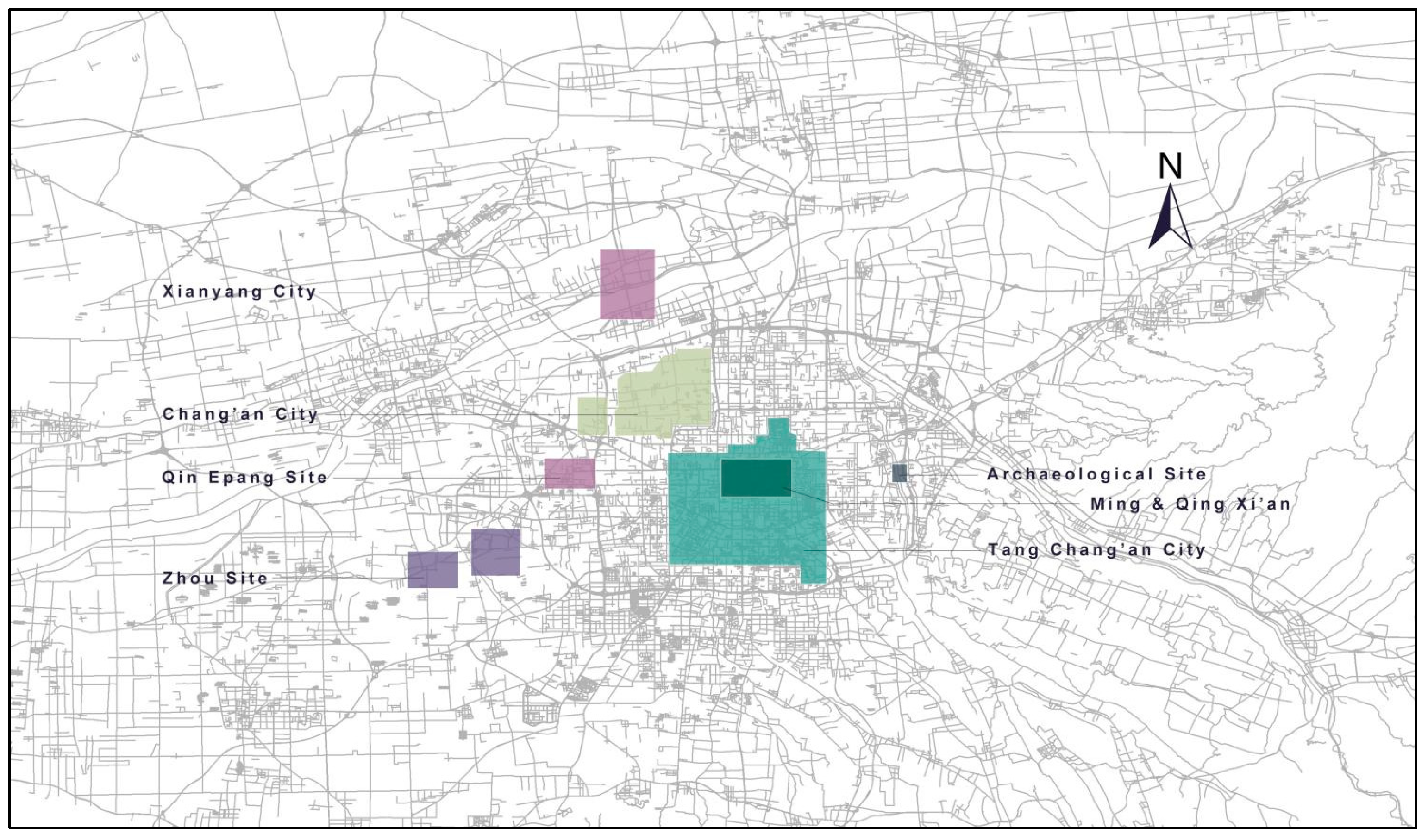
Figure 2.
Xi'an historical city development level.
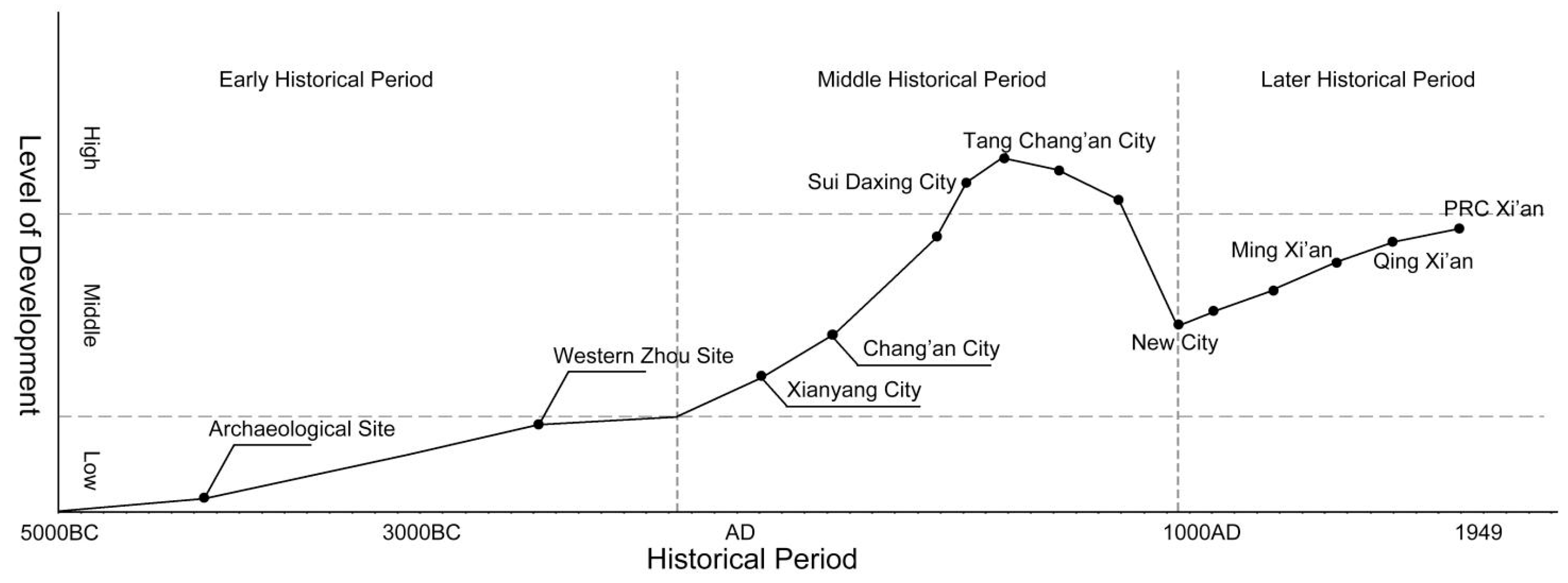
Figure 3.
Knowledge mapping of historical maps based on wos database.
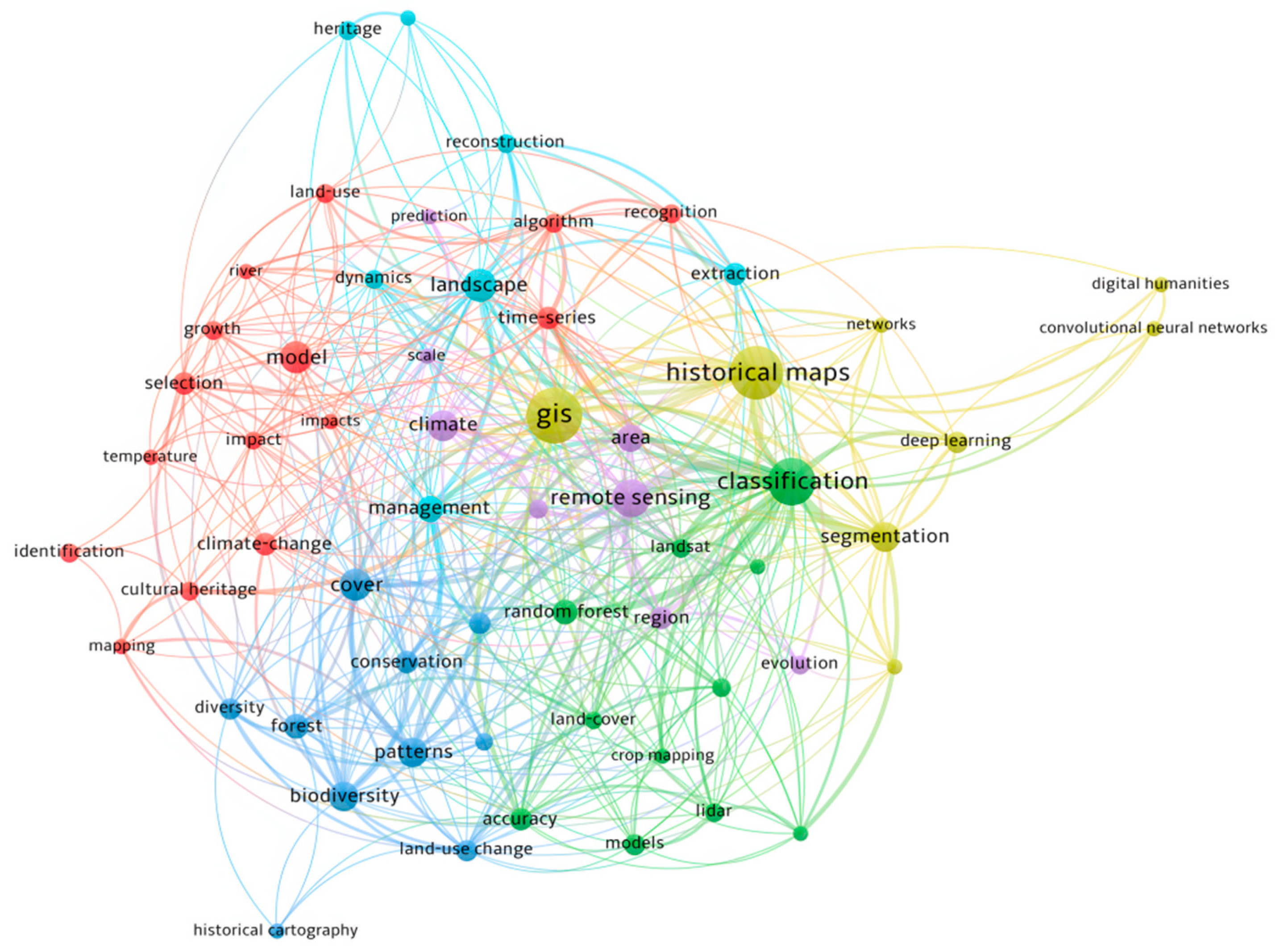
Figure 4.
Knowledge mapping of historical gis based on wos database.
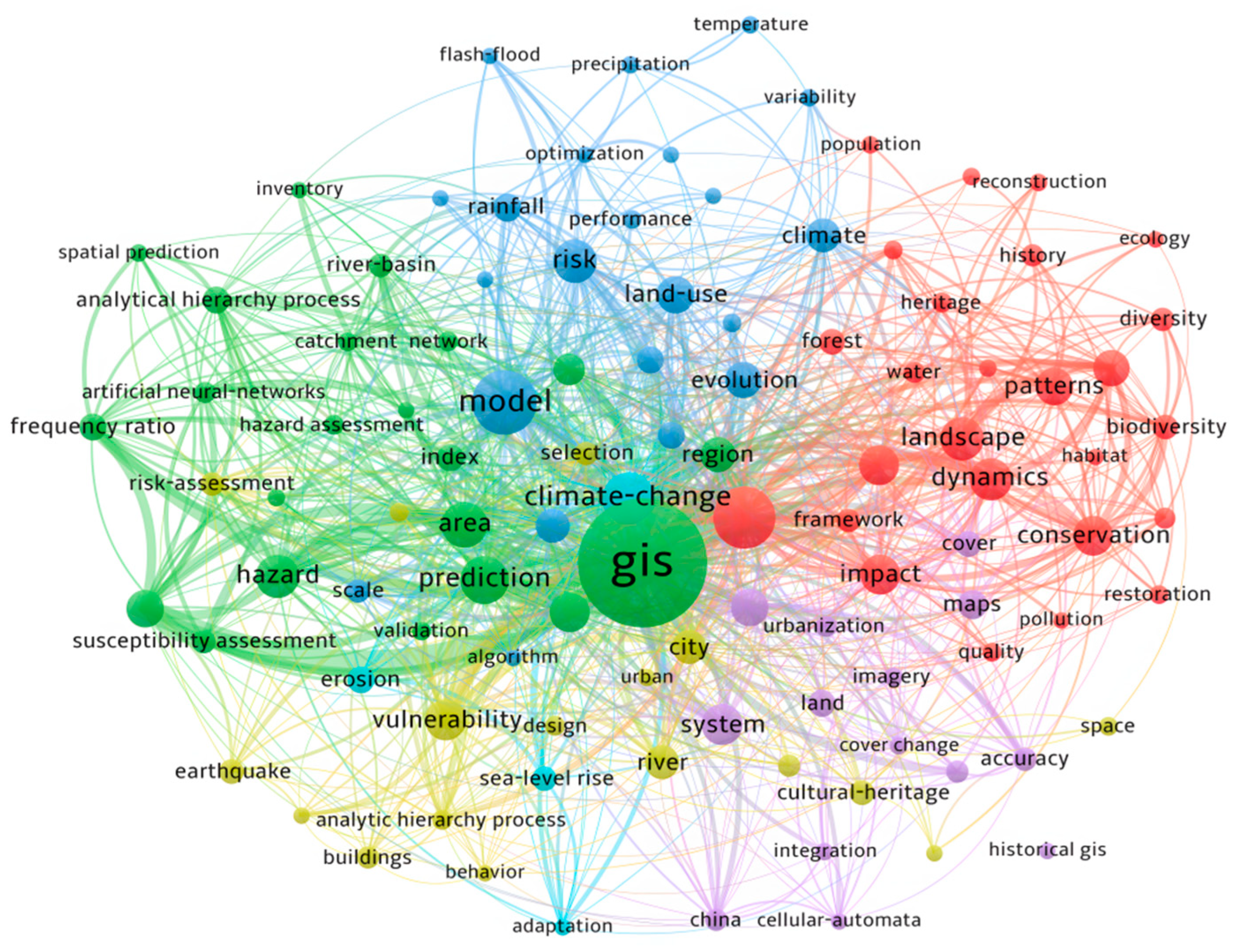
Figure 5.
Historical map of Xi'an during six different dynasties.
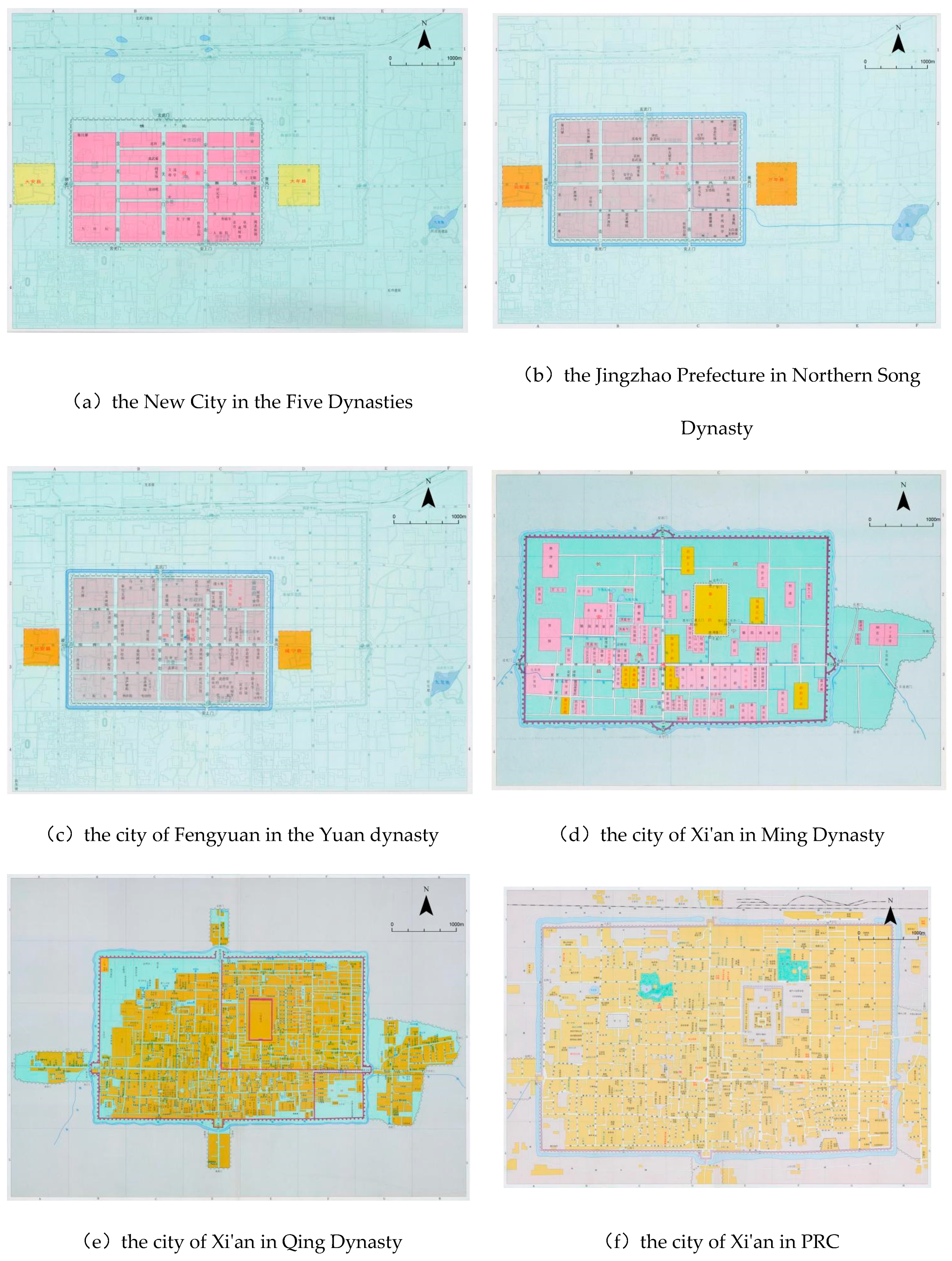
Figure 6.
The Evolution of Xi'an's Urban Spatial Structure.
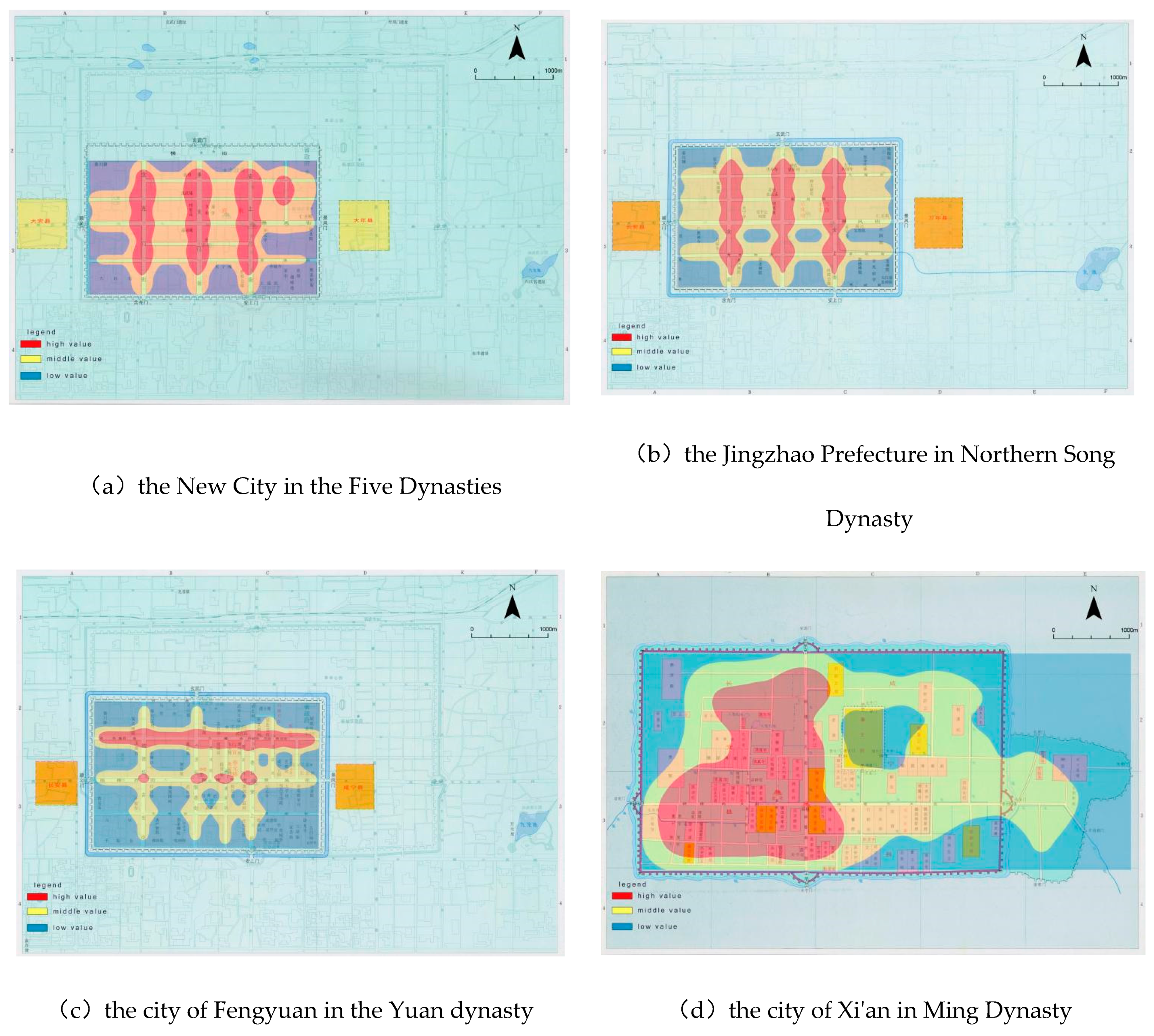
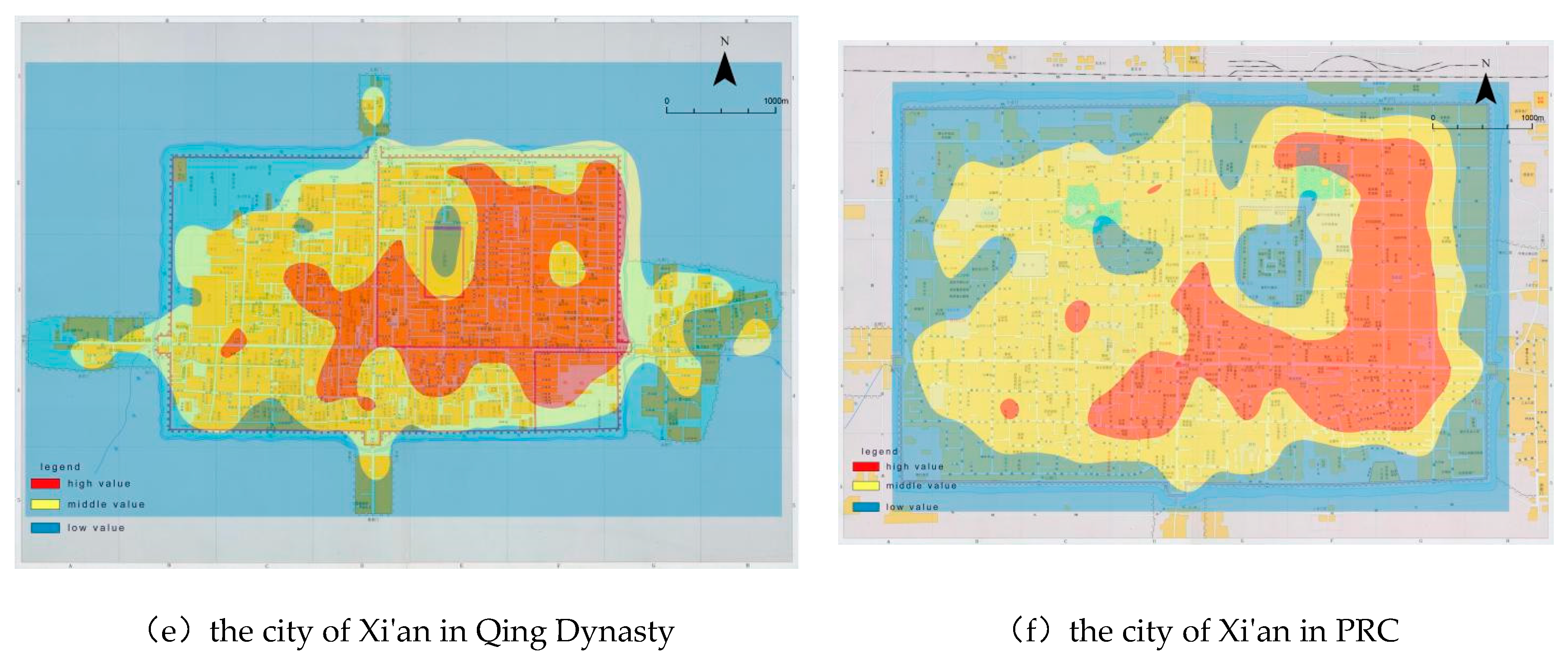

Table 1.
Statistical of major research reviews on historical gis.
| No. | Research Direction in Historical GIS | Key Figures (Organizations) | Research Outcomes or Methods | Challenges | Type |
|---|---|---|---|---|---|
| 1 | Digitization of Historical Maps and Information[47] | Spence, Fudan University | GBGIS、CHA、CHGIS | Numerous historical sites make precise digitization difficult | Digitization, storage, management, and analysis of historical maps |
| 2 | Historical Geographic Information Systems[48] | American Geographical Society, University of Portsmouth, Fudan University | U.S. National Historical Geographic Information System, Irish Famine Atlas Platform, Chrono-Spatial Framework of Chinese Civilization | Difficulty in standardizing platforms; challenges in building databases and back-end infrastructure to support high-traffic access | |
| 3 | Historical Geographic Data Models[49] | Langran, Griffiths, Xu Zhihong | Tripod Spatial Historical Data Model | Requires proficiency in computer programming | Using models to analyze historical maps |
| 4 | Spatial Analysis of Historical Geographic Information[50] | Longley、Gregory,Zhang Hai | geographical statistics、regression analysis | Lack of complex, model-based data; limited analytical methods | |
| 5 | Visualization of Historical Geographic Information[51] | Sadahiro、Li Haiping | Tokyo Urban Historical Landscape, American Glacier Evolution Simulation | Lack of high-precision millimeter-wave radar scanning and VR equipment |
Table 2.
Key Concepts and Formulas in Space Syntax.
| No. | Concept | Formula | Description |
|---|---|---|---|
| 1 | Connectivtiy | The number of connections between a space (x) and its adjacent spaces (y) | |
| 2 | Integration | The inverse of the average length of the shortest paths from a specific space (x) to all other spaces (y) | |
| 3 | Control Value | The degree to which a space (x) controls its adjacent spaces (y) relative to other spaces (z) |
Disclaimer/Publisher’s Note: The statements, opinions and data contained in all publications are solely those of the individual author(s) and contributor(s) and not of MDPI and/or the editor(s). MDPI and/or the editor(s) disclaim responsibility for any injury to people or property resulting from any ideas, methods, instructions or products referred to in the content. |
© 2024 by the authors. Licensee MDPI, Basel, Switzerland. This article is an open access article distributed under the terms and conditions of the Creative Commons Attribution (CC BY) license (http://creativecommons.org/licenses/by/4.0/).
Copyright: This open access article is published under a Creative Commons CC BY 4.0 license, which permit the free download, distribution, and reuse, provided that the author and preprint are cited in any reuse.


