
Submitted:
24 July 2023
Posted:
25 July 2023
You are already at the latest version
Abstract
In the last decades, climate and environmental changes have highlighted the fragility and vulnerability of the landscape, especially in mountain areas where the effects are most severe. The strategy for hazard mitigation must deploy synergistic actions based on a thorough knowledge of the territory and its phenomena to enable integrated and effective land planning and management through suitable communication tools. This study promotes the methodological setup of a Landscape Digital Twin to establish a multi-disciplinary and multi-scalar hazards overview according to a matrix framework implementable over time and space. The original contribution to the research addresses a holistic vision that combines meaningfully qualitative with quantitative approaches to generate risk maps by integrating various indicators within a multi-hazard framework from the socio-economic perspective. This contribution presents road network risk analysis by exploiting flooding and landslide scenarios. The critical road segments or nodes most vulnerable or impacted by network performance and accessibility can be identified with minimal preprocessing from credible open-source sources. The method's applicability is tested in a Piedmont Region, northern Italy case study. The integration proposed will help generate comprehensive risk analysis maps that effectively portray the interconnectedness among natural hazards, infrastructure, and socio-economic factors fostering more resilient decision-making processes.
Keywords:
Landscape Digital Twin
; GIS
; natural hazards
; road
; floods
; landslide
; risk analysis
; open-source data
; risk maps
; socio-economic approach
Abstracts: In the last decades, climate and environmental changes have highlighted the fragility and vulnerability of the landscape, especially in mountain areas where the effects are most severe. The strategy for hazard mitigation must deploy synergistic actions based on a thorough knowledge of the territory and its phenomena to enable integrated and effective land planning and management through suitable communication tools. This study promotes the methodological setup of a Landscape Digital Twin to establish a multi-disciplinary and multi-scalar hazards overview according to a matrix framework implementable over time and space. The original contribution to the research addresses a holistic vision that combines meaningfully qualitative with quantitative approaches to generate risk maps by integrating various indicators within a multi-hazard framework from the socio-economic perspective. This contribution presents road network risk analysis by exploiting flooding and landslide scenarios. The critical road segments or nodes most vulnerable or impacted by network performance and accessibility can be identified with minimal preprocessing from credible open-source sources. The method's applicability is tested in a Piedmont Region, northern Italy case study. The integration proposed will help generate comprehensive risk analysis maps that effectively portray the interconnectedness among natural hazards, infrastructure, and socio-economic factors fostering more resilient decision-making processes.
1. Introduction
1.1. Background and Motivation
Nowadays, the Alpine space is facing significant challenges: the need for increasing digital and ecological transition is compounded by ageing and emigration trends. Repopulating mountain areas in a sustainable and digital key [1], requires a wide-ranging multidisciplinary and multi-scalar strategy to produce tangible impacts on the territory. This need is even more pronounced concerning climate and environmental changes. Indeed, mountains are very sensitive and more vulnerable to the effects of such modifications, with clearly visible and amplified responses affecting their morphology.
Global warming has decreased the extent of snow and ice-covered areas to make way for darker soil that can absorb solar radiation and warm. Permafrost, ice segregation, and a higher frequency of extreme precipitation events have been argued to be responsible for increased slope-failure events over the last decades [2]. At the same time, the danger of flooding phenomena [3], is mainly attributable to anthropogenic causes, such as building in high-risk areas, urbanization, and often uncontrolled cementing, as well as deficiencies in cleaning riverbeds and surrounding areas, which have reduced the flood containment capacity, making the risk of flooding high. The human settlements established in the valleys and the infrastructures are thus directly or indirectly threatened from time to time [4]. Since road transportation networks are essential for the mobility and accessibility of people and goods to critical facilities and services [5,6,7] and for the regions’ economic and social development, assessing the impact of hazards on these is crucial for enhancing their resilience and reducing risk.
While studies have always been oriented toward the built and historical heritage for preservation, management and maintenance purposes, understanding the landscape is crucial today more than ever. An in-depth knowledge of the territory and monitoring of its transformations is urgently needed. Specifically, it is necessary to have a scalable multi-hazard framework that can integrate diverse data types while considering their contextual information and address the gap in understanding the socio-economic effects of natural hazards. Such a framework can help to identify the most vulnerable areas and populations, evaluate the potential impacts and risks of different scenarios, and support the decision-making process for disaster preparedness and mitigation.
The methodological setting of a Digital Twin (DT) [8], constitutes the paradigm around which to hinge any potential theoretical and practical developments. This research front is supported by the European Commission, which first targeted this flagship initiative through the Destination Earth (DestinE) project [9], which aims to develop a highly accurate digital model of the Earth on a global scale to guarantee a sustainable future. The European Space Agency is also moving in this direction through a new representation of the Earth System based on integrating Earth Observation data, inter-connected numerical simulations, and Artificial Intelligence [10]. The Mountain Digital Twin is a digital model of the mountain that is created through the acquisition of all available data to have a snapshot of the complexity of the territory. The spatial representation based on the oro-geographical model is enriched in real-time by the data collected in the field, which are used to create simulations, reasoning, and predictive scenarios. Therefore, the idea of DT focuses on the possible content and levels of knowledge to be handled for land planning and management.
This study promotes a matrix view of hazards affecting the land by promoting methods and tools to relate specialized data and simulations of each domain to each other with geospatial databases. Specifically, a framework that relates the transportation network to floods and landslides is presented. The method is validated through a real-world case study. The potential for creating these intersections of data, tools and methodologies emerges immediately, corroborating the approach and opening up new segments of specific experimentation.
1.2. Literature Review
Natural hazards are extreme events that threaten human lives, livelihoods, and environments [11]. They can cause direct impacts resulting from the physical contact of people and assets with the hazard agent, such as deaths, injuries, damages, and losses and indirect effects which disrupt the normal functioning of society and the economy due to hazardous events, such as displacement, unemployment, poverty, and social unrest [12]. According to the United Nations Office for Disaster Risk Reduction (UNDRR), natural hazards affected more than 4.2 billion people and caused over $2.9 trillion in economic losses between 2000 and 2019 [13]. Moreover, natural hazards are expected to increase in frequency and intensity due to climate change, population growth, urbanization, and environmental degradation [14].
One of the significant challenges in disaster risk management is understanding and assessing the socio-economic effects of natural hazards, which are often complex, dynamic, and context-specific [15]. They can be influenced by factors such as populations' exposure, vulnerability, coping capacity, recovery potential, and adaptation strategies [6]. The effects can also vary depending on the events' type, magnitude, frequency, duration and combination of natural hazards [16]. Short-term results occur immediately or shortly after the hazard event, such as rescue operations, emergency relief, and temporary shelter [17]. Long-term effects persist for months or years after the hazard event, such as reconstruction, recovery, and adaptation [18]. Socio-economic effects can significantly affect human societies' well-being, development, and sustainability. For instance, natural hazards can reduce income and consumption levels, increase inequality and poverty rates, disrupt education and health services, degrade natural resources and ecosystems, and undermine social cohesion and trust [19,20].
Therefore, understanding and assessing the socio-economic effects of natural hazards is essential for designing and implementing adequate disaster risk management policies and strategies. Most studies have focused on single-hazard events, overlooking the possibility and reality of multi-hazard events [21]. Multi-hazard events are situations where two or more natural hazards occur simultaneously or sequentially in the same area, causing compounded or cascading effects [22]. For example, earthquakes can trigger landslides and tsunamis, and floods can cause mudflows and power outages. Only a multidisciplinary approach can capture the complexity, diversity, and dynamism of human-hazard interactions. It also requires a comprehensive data collection and analysis system integrating different sources and data types at different spatial and temporal scales [23].
A multi-hazard process considers the interactions and interdependencies among multiple dangers and their impacts on human societies. It provides a more realistic and comprehensive picture of different areas and populations' potential risks and vulnerabilities. It can also help identify synergies and trade-offs among disaster risk management options for various hazards [24,25,26].
However, implementing a multi-hazard approach is a challenging task. It faces several conceptual, methodological, and practical challenges due to the differing characteristics of natural hazards [26].
One of the aspects that can enhance the understanding and assessment of the socio-economic effects of natural hazards is the use of visualization tools that can display the multi-hazard scenarios and their impacts clearly and intuitively. Visualization tools can help communicate complex and uncertain information to different stakeholders, such as decision-makers, planners, enginclearly and intuitivelyeers, and the public, and facilitate their participation and collaboration in disaster risk management. Moreover, visualization tools can support analyzing and evaluating different disaster risk management options and their trade-offs, such as mitigation, preparedness, response, and recovery measures [27]. However, most of the existing visualization tools for natural hazards are limited to two-dimensional (2D) maps or charts that cannot capture the spatial and temporal dynamics of multi-hazard events and their effects on the built environment. Therefore, there is a need for more advanced visualization tools that can leverage the three-dimensional (3D) spatial data embedded in building information models (BIMs) and city information models (CIMs) to create realistic and interactive representations of multi-hazard scenarios and their impacts on individual buildings and urban areas.
From the literature analysis, the existing knowledge gap intended to be covered through this paper is detectable. This research paper emphasizes adopting a multi-hazard approach to capture a more realistic and comprehensive understanding of the socio-economic impacts. Additionally, the methodology employed in this study is designed to be scalable, meaning it can be applied to other study areas, enhancing the generalizability and practicality of the findings.
1.3. Significance of the Study
This study contributes to the existing literature on disaster risk management by providing a novel approach to assess the socio-economic effects of natural hazards using a scalable multi-hazard framework.
The general objectives are:
- To define and operationalize risk analysis indicators that capture the socio-economic effects of natural hazards.
- The definition and operationalization of risk analysis indicators can reflect the socio-economic effects of natural hazards on people's lives.
- To present the risk analysis outcomes in terms of qualitative (risk maps) and quantitative (origin-destination matrix graphs) outputs.
- To perform and compare risk analysis with several categories of points of interest (POIs) under different scenarios.
- To calculate risk scores based on a robust formula that considers the type of point of interest, the type of hazard, and the land cover classification.
- To propose a scalable methodology that can integrate multiple data sources and types for multi-hazard analysis.
Specifically, the scope of this research paper is limited to:
- The focus on road network accessibility as a risk indicator.
- The road network analysis according to different types of points of interest (health facilities, public facilities, town centers, and tourism facilities) under different scenarios (basic, disrupted).
- The consideration of two types of natural hazards: landslides and floods.
- The use of publicly available credible data sources such as government portals.
- The application of open-source tools such as Quantum Geographic Information System (QGIS).
The integrated approach has been validated through a real-world case study in the Piedmont region of Italy. As the Orco Valley has experienced severe flood and landslide events in the past, flood and landslide hazard maps from existing sources or models have been used to create disrupted scenarios for the road network in the valley.
2. Materials and Methods
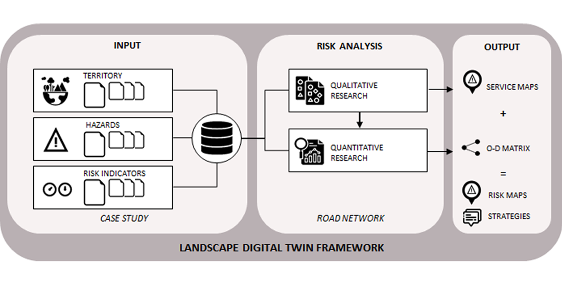
As anticipated in the previous section, the specific objective is to create a scalable method that generates risk maps by integrating different data domains to perform a road network risk analysis, within a multi-hazard framework, specifically in the context of a socio-economic perspective. The research framework described in Figure 1 consists of the following main steps: (i) the selection of a case study for the experimentation; (ii) the definition of the input data; (iii) the risk analysis performed both within qualitative and quantitative research; (iii) the outcomes achieved, (iv) the scalability of the system according to a Landscape Digital Twin vision. The methodological approach is described in this section, while the practical application to the case study is described in the results.
2.1. Case study area
The methodology has been tested by taking the Orco Valley on the Graian Alps in the metropolitan area of Turin (Italy) as a reference case study. The valley, located in the central part of the Gran Paradiso Massif, is carved by the Orco River, and it is characterised by a landscape typical of glacial valleys where the shaping action of glaciers over millennia is evident and a slow process of deep-seated gravitational slope deformation is undergoing. Its orography is very interesting as it includes several mountains and alpine passes [28]; it is rich in lakes, some natural alpine other artificial reservoirs as several hydroelectric power plants are situated. It runs mainly in a west-east direction and is particularly narrow, especially in the central part, where some villages in winter do not see the sun for many days. The five main centres are Ceresole Reale, Noasca, Locana, Sparone, and Pont Canavese, with a population of about 5,620 inhabitants [29], as shown in Figure 2. The valley has acquired a great vocation for tourism, mainly related to the presence of the Gran Paradiso National Park, and is renowned for its many climbing routes. Agriculture and forestry are the main economic activities as well. In the last two centuries, the Orco basin has been repeatedly struck by major flood events that have seriously affected the hillslopes and along the hydrographic network causing damage to infrastructure and occasionally fatalities [30,31]. The increase in human activity along the valley floor and the lack of room for flood expansion have forced people to occupy high-hazard zones such as alluvial fans, intravalley plains, and river corridors. The major damage observed is attributable to a highly complex landslide, historically known as the “Rosone landslide”, belonging to an extensive deep-seated gravitational deformation that was reactivated following intense rainfall, leading to rock falls and soil slips which reached the highway, damaging it in several places. Figure 3 maps the damage recorded for flooding, landslides, and riverbank erosion. As it is possible to observe from the infographic, unstable areas represent most of the territory, with the punctual presence of areas marked by high hydrogeological risk in correspondence with the villages of Noasca, Rosone and Sparone. The only National Road No. 460 from Turin to Ceresole Reale is located at the toe of the slope.
2.2. Input
The starting point to carry out any land investigation is always data availability. In the case of specific projects, these are collected from the state of the art and, if necessary, integrated on an ad hoc basis with punctual surveys and monitoring activities. This research promotes a streamlined method for risk assessment through minimal data preprocessing. Therefore, it is essential to refer to credible and publicly available data sources to achieve this goal. These thus prove to be a valuable shared reference, facilitating the integration of diverse information layers managed by specialists in each domain. For this study, three main categories of data can be identified: (i) those referring to the territory and its graphical representation, (ii) hazard maps, and indicators.
- Territory
The concept of territory is essential in multi-hazard risk analysis, as it refers to the area under examination, including its physical, social, economic, and environmental aspects. To conduct meaningful research, data related to the territory is crucial, and this involves gathering and integrating meaningful information from various sources such as satellite imagery, elevation models, land cover maps, road networks, and census data.
A significant part of data acquisition is identifying and selecting critical points of interest within the territory. These POIs represent essential facilities that play a vital role in the well-being and resilience of the population and infrastructure in terms of socio-economic development. This study chooses the commune level as the territorial scale for the multi-hazard risk analysis. A commune is an administrative division corresponding to a municipality or town in Italy. This scale helps capture the spatial variability and socio-economic factors affecting vulnerability and exposure to natural hazards in the case study area. Reliable data sources are available at this level from official government portals, including emergency points providing healthcare and emergency services, public points supporting social and economic development, and tourism points contributing to economic activity and cultural identity. Figure 4 provides an infographic of tourist points of interest, such as panoramic routes, heritage enhancement points, trial networks, sanctuaries, and mines.
Analyzing these POIs at the chosen territorial scale allows for a comprehensive and realistic assessment of vulnerability and exposure to natural hazards in the case study area. Integrating data acquisition with specific territorial characteristics enhances the accuracy and effectiveness of the multi-hazard risk analysis.
- Hazard
Natural hazards are inherent events or phenomena that arise from natural processes and can potentially cause harm or damage to people, property, infrastructure, or the environment. These hazards can be categorized into several types, including geological, hydrological, meteorological, climatological, or biological hazards. Each type exhibits distinct characteristics, causes, triggers, frequency, intensity, duration, and impacts. Consequently, evaluating the risk associated with natural hazards is vital for understanding the likelihood and severity of their occurrence, and their potential repercussions on socio-economic functions and activities within a specific area.
The Orco Valley is exposed to numerous natural hazards, particularly landslides and floods. These hazards threaten the road network and socio-economic activities in the valley. Landslides predominantly occur due to rainfall, snowmelt, or seismic events, forming rockfalls, debris flows, or slides. Meanwhile, floods are primarily caused by heavy or prolonged rain, snowmelt, or glacial lake outbursts (GLOFs), leading to riverine or flash floods. Figure 5 provides an overview of the hazard maps depicting the distribution of potential hazards within the study area.
- Risk indicators
Risk indicators are variables or parameters that gauge the level of natural hazard risk in a specific area. These indicators are derived from various sources, including historical records, statistical models, simulation models, expert opinions, or surveys. Employing risk indicators is crucial in risk analysis as they aid in comprehending the probability and severity of natural hazards, along with their potential impact on socio-economic functions and activities in the region.
In this study, the primary focus for multi-hazard risk analysis is road network accessibility, defined as the capacity to reach a destination using the road network in the area under examination. This indicator directly reflects the socio-economic functions and activities reliant on the road network within the case study region. Natural hazards like landslides and floods can adversely affect road segments or nodes, impacting road network accessibility. By employing this indicator at the commune level as the territorial scale for multi-hazard risk analysis, the study offers a comprehensive and realistic assessment of the vulnerability and exposure of the population and infrastructure to natural hazards within the case study area. Figure 6 shows the road network for the case study.
2.3. Risk analysis
The study assesses natural hazards' potential impacts on human societies and assets in the Orco Valley. This process, commonly known as risk analysis, involves estimating the consequences of hazardous events. Through risk analysis, vulnerable areas and populations can be identified, various scenarios and uncertainties can be evaluated, and decision-making for disaster risk management can be supported. The methods and approaches used for risk analysis vary depending on factors such as the type and scale of the hazard, data availability and quality, as well as the purpose and scope of the analysis. The study adopts a multi-hazard approach that integrates both qualitative and quantitative methods to assess the socio-economic effects of natural hazards on the road network and POIs in the Orco Valley. By combining these approaches, a comprehensive understanding of the risks posed by various hazards can be achieved, enabling more effective disaster risk management strategies.
2.3.1. Road network analysis
Road network analysis (RNA) is a method to assess the accessibility and connectivity of road networks under different scenarios [43]. It can provide useful information on the potential impacts of natural hazards on road infrastructure and the socio-economic activities that depend on it. RNA can also help identify critical road segments or nodes vulnerable or exposed to natural hazards . Network modeling and network analysis are the two main steps. The first involves creating a graph representation of the road network using nodes (intersections or terminals) and links (road segments). The second consists of applying different algorithms or methods to measure various network attributes or performance indexes such as travel time, travel distance, travel cost, accessibility, connectivity, reliability, redundancy, etc.
In this study, RNA was performed using QGIS [44], and QNEAT3 plugin [45], which are open-source tools for spatial and network analysis. QGIS is a geographic information system software that allows users to create, edit, visualize, analyze, and publish geospatial data. QNEAT3 is a QGIS plugin that provides a set of algorithms and tools for network analysis within QGIS. QNEAT3 can generate different types of outputs from RNA, such as service maps used as qualitative research and origin-destination (O-D) matrices used as quantitative research.
2.3.2. Qualitative research
Qualitative research is a method that aims to describe and interpret the characteristics, patterns, and relationships of natural hazards and their impacts using non-numerical data such as texts, images, maps, or diagrams [46]. Qualitative research can provide a rich and contextual understanding of the phenomena under study and capture the diversity and complexity of human-hazard interactions. Qualitative research can also complement quantitative research by providing additional insights or explanations that may not be captured by numerical data alone.
This study utilized qualitative research to generate service maps of the POIs under different scenarios of natural hazards. Service maps are polygons that show the reachable areas within a given travel cost from a POI. They can illustrate the spatial distribution and extent of accessibility and connectivity of road networks under different conditions. Service maps can also help identify the areas most affected by natural hazards in terms of reduced or disrupted service provision.
Service maps were used as input for calculating the exposure of a POI to a hazardous event in the risk score formula. Exposure is the degree to which people, property, infrastructure, or the environment are susceptible to harm or damage from natural hazards [38]. Exposure can be measured by indicators such as population density, asset value, land use type, or critical facility type [39]. In this study, exposure is measured by the service area of a POI under different scenarios of natural hazards.
2.3.3. Quantitative research
Quantitative research is a method that utilizes numerical data like statistics, graphs, tables, or equations to measure and quantify the characteristics, patterns, and relationships of natural hazards and their impacts [46]. It offers a precise and objective understanding of the phenomena under study and allows for testing hypotheses or models based on empirical evidence. Additionally, quantitative research can complement qualitative research by providing numerical support or validation for findings from non-numerical data such as service maps.
This study utilized quantitative research to generate origin-destination matrices of the POIs under different scenarios of natural hazards. O-D matrices are tables that show the travel cost between each pair of POIs in a road network. They can illustrate the numerical distribution and extent of accessibility and connectivity of road networks under different conditions. O-D matrices can also help identify the POIs most affected by natural hazards in terms of increased or decreased travel costs.
O-D matrices were used as input for calculating the vulnerability of a POI to a hazardous event in the risk formula. Vulnerability is the degree to which people, property, infrastructure, or the environment will likely experience harm or damage from natural hazards [38]. Vulnerability can be measured by indicators such as physical fragility, functional dependency, adaptive capacity, or coping strategies [39]. In this study, vulnerability is measured by the change in travel cost between POIs under different scenarios of natural hazards.
2.4. Outputs
The output of the multi-hazard risk analysis is a set of risk scores and risk maps for the POIs in the Orco Valley under different scenarios of natural hazards. The risk scores and risk maps are derived from integrating the qualitative and quantitative approaches using the service maps and the O-D matrices, and other variables based on literature as inputs.
The risk score formula is a method to estimate the potential impact of natural hazards on a POI based on a combination of factors that influence risk. It can provide a simple and intuitive way to compare and rank different POIs according to their level of risk exposure. From the risk score, it is then possible to identify priority areas or actions for disaster risk reduction or mitigation.
In this study, a dynamic formula was employed, considering the POI type, hazard type, land use/land cover (LULC) classification, and other economic indicators. The formula is as follows:
where:
R=P×E×V×C×L×O
- R is the normalized risk score for a POI in a scenario.
- E is the exposure level for a POI in a scenario, measured by the service area from the qualitative analysis, which represents the potential impact of the hazard on the POI.
- V is the vulnerability level for a POI in a scenario, measured by the change in travel cost from the quantitative analysis, which represents how much the hazard affects the accessibility and connectivity of the POI.
- O is another economic indicator, derived from data availability, which can either increase or decrease the risk depending on how they affect the economic or social aspects of the POI.
The values P, C, and L are derived from literature on a scale of 0 to 2, with higher values indicating higher risk. The risk score formula was applied to each type of POI using qualitative and quantitative analysis, resulting in Risk Maps. Then those risk maps are normalized between 0 and 1 to get the risk scores.

Table 2.
Range of Values taken for the Consequence level for a POI in a scenario.
| Point of interest | Consequence (C) |
|---|---|
| Health facility | 1.6-2.0 |
| Public facility | 1.4-1.6 |
| Town center | 1.2-1.4 |
| Tourism facility | 1-1.4 |
The consequence values for different points of interest types are based on how important and valuable they are for providing essential services and functions to people and society. For example, a health facility that provides medical care and emergency response would have a high consequence value. In contrast, a tourism facility that offers recreational and cultural services would have a low consequence value.
Table 3.
Values taken for the Land cover type.
| Land use/land cover type | LULC (L) |
|---|---|
| Water | 1 |
| Forest | 0.8 |
| Urban | 1.4 |
| Rock | 1 |
| Snow | 0.6 |
The effect values for different land use/land cover types are based on how they influence the service area of the POIs. For example, urban land use/land cover type would positively affect the service area, as it provides more infrastructure and facilities for people and services. In contrast, snow land use/land cover type would have a negative effect on the service area, as it reduces mobility and accessibility for people and services.
Table 4.
Value for the Probability of occurrence of a hazardous event.
| Hazard type | Return period (years) | Probability (P) |
|---|---|---|
| Landslide | 10 | 0.5 |
| Landslide | 50 | 1 |
| Landslide | 100 | 1.5 |
| Flood | 10 | 0.6 |
| Flood | 50 | 1.1 |
| Flood | 100 | 1.4 |
The probability values for landslide and flood hazards are based on how likely they are to happen in a given period of time. For example, a landslide with a return period of 10 years would have a low probability value, as it is less likely to occur than a landslide with a return period of 100 years, which would have a high probability value.
One of the advantages of using this risk score formula is that it can be updated dynamically using live data from IoT devices, Earth observation satellites, or other sources. This can help to capture the changes and uncertainties in the natural hazard environment and the human system. For example, IoT devices can provide real-time data on the status and location of POIs, such as wearable medical devices or smart sensors. Earth observation satellites can provide near-real-time data on the hazard intensity and extent, such as flood maps or landslide detection. Other sources can provide updated data on the economic or social indicators, such as market prices or population statistics. By integrating these data sources into the risk score formula, we can obtain more accurate and timely estimates of the risk exposure and impact of natural hazards on the POIs.
3. Results
The study assessed road network condition and vulnerability by comparing RNA results under different scenarios: basic (no hazard), disrupted due to floods, and landslides. Service maps and O-D matrix graphs for each POI were used to explore the socio-economic perspective of multi-hazard risk analysis. Risk maps showed spatial distribution of risk scores for each POI and hazard, while O-D matrix graphs displayed changes in travel time between POIs under various scenarios. These insights are valuable for evaluating the road network and POIs' resilience and recovery in the face of natural hazards, influenced by factors like POI location, hazard intensity, alternative routes, and mitigation strategies.
3.1. Quanlitative Analysis: Service Maps
- Hazard Emergency Services Facilities
Figure 8 shows that the health facilities are exposed to varying levels of Service depending on their location and the type of hazard. The serivce maps indicate that the health facilities in Ceresole Reale, situated at the end of a road prone to flood, faces challenges during hazardous events. To ensure continuous access to medical services, it's essential to establish additional health facilities in Noasca and Ceresole Reale, especially in mountainous regions. The risk maps also suggest that the health facilities may need to coordinate and cooperate in providing medical services and assistance to the affected population in case of a natural hazard event.
- Public Facilities
The Figure 9 shows that public facilities are exposed to varying levels of Service depending on their location and the type of hazard. The service maps indicate that public facilities in Noasca, including the town hall and post office, are highly exposed to both floods and landslides. To enhance their resilience and recovery during hazardous events, it is crucial to consider alternative routes and implement appropriate mitigation and response strategies. Coordination and cooperation among public facilities may also be necessary to ensure the continuity of essential services and maintain public order during natural hazard events.
- Critical infrastructures
The Figure 10 shows that also critical infrastructure is exposed to varying levels of service area depending on its location and the type of hazard. The hydroelectric power plant in Rosone serves a important energy source for the downhill areas of Turin, Italy, producing around 99 MWh energy. The figure shows that the power plant is the highly prone to the landslide hazard suggesting an intervention to increase resilience.
- Town Centers for Public Activity and Mobility
Figure 11 shows the service maps for town centers under different scenarios. The figure shows that the town centers are exposed to varying levels of risk depending on their location and the type of hazard. The service maps reveal that in the event of landslides and floods, the accessibility of all five town centers, especially Ceresole Reale and Noasca, becomes limited. To enhance their resilience and recovery during hazardous events, it is crucial to consider alternative routes, implement appropriate mitigation and response strategies, and promote coordination among town centers to support economic activity and mobility in the valley.
- Tourism Facilities
Figure 12 shows the service maps for tourism facilities under different scenarios. While many tourism facilities remain relatively unharmed during hazards, there is a crucial concern regarding the accessibility of the road SS2460 near Madonna delle Grazie al Gurgo Church in Locana. This road, being prone to both landslides and floods, becomes inaccessible during such events. This inaccessibility poses a significant impact on tourism, particularly for urban populations seeking to explore the uphill areas of Locana, Noasca, and Ceresole Reale. As a consequence, the flow of visitors to these areas decreases, leading to a decline in tourism activity and potential economic losses. To address this issue, it is essential to consider the construction of alternative road that can serve as additional entry points to the region. Having alternative routes will enhance the resilience of the tourism sector, ensuring uninterrupted access to the uphill areas even during hazardous events. Additionally, implementing measures such as flood protection for specific areas and developing evacuation plans can further mitigate the risks and enhance the overall resilience of the tourism facilities in the Orco Valley.
3.2. Quantitative Analysis: O-D Matrix Graphs
To comprehensively analyze risks, separate O-D matrix evaluations were conducted for flood and landslide hazards, resulting in 12 distinct assessments for the risk score formula. Figure 13 provides a concise summary depicting the accessibility of POIs after natural hazards compared to the baseline scenario. Results reveal that after the hazards, accessible emergency services reduced to 36 for floods and 33 for landslides, down from 90 in the basic scenario. Similarly, public services decreased from 45 to 25 for floods and 25 for landslides. Tourism facilities decreased to 79 for floods and 72 for landslides, from 120.
3.3. Risk Maps and Risk Scores
The risk score analysis was performed using the risk scores formula for each type of POI and hazard under different scenarios. The risk scores are values that measure the potential impact of natural hazards on a POI based on a general formula that considers the type of POI, the type of hazard, and the LULC classification.
Figure 14 shows an example of a land cover classification map for the Orco Valley, which is used to update the risk maps according to the land cover as stated in previous chapters. Figure 15 presents the risk maps based on risk scores for emergency services, town centers, public facilities, tourism facilities, hydroelectric power plant system.
4. Discussion
The multi-hazard risk analysis in this study offers valuable insights for decision-making and preparedness in the Orco Valley. Risk maps and O-D matrix graphs help identify vulnerable points, critical road segments, and affected communities. They also evaluate the impact of hazards on socio-economic activities. Decision-makers can then implement measures like contingency plans, protection measures, alternative transportation routes, coordination among POIs, public awareness campaigns, and investment in disaster risk reduction. The analysis serves as a baseline for monitoring progress and can be updated with real-time data for comparison and trend assessment.
4.1. Scalability: Landscape Digital Twin model
The methodology employed in this study is designed to be scalable, meaning it can be applied to other study areas with different data sources and types of natural hazards. Due to the heterogeneous data environment and multidisciplinary nature characterizing the landscape, the definition of a Digital Twin provides the guiding principle for future work. The Landscape Digital Twin (LDT) model can monitor, analyze, and simulate the interactions and feedback between natural and human systems and support sustainable development and management of natural resources.
Accordingly, some researchers have presented architectures and frameworks [47] to address the data integration and management challenges. The LDT architecture involves five main layers: physical, data storage, integration, application, and visualization. Figure 16 presents the LDT model architecture for multi-hazard risk analysis.
The visualization layer stands crosswise from all others. In this way, the dta is exposed and queried according to differentiated levels of processing.
The physical layer represents the physical environment and includes sensors collecting information by monitoring variables of interest. For example, rain gauges or systems to detect the evolution of a landslide. Sensor data are transferred to a dedicated database in the data storage layer via protocols such as HTTP.
The data storage layer identifies two primary data sources environment: static data for the landscape knowledge base and dynamic data from IoT devices. Physical territory mapping is handled by the GIS. However, Building Information Models (BIM) representations of significant buildings/infrastructure can enrich the understanding of the dynamics of the territory.
The integration layer involves processing and harmonizing data from different sources. It performs simulation, monitoring, and prediction tasks using different models and algorithms. For example, hydrological and geological models can simulate flood and landslide hazards under different rainfall scenarios, climate change, land use change, etc. Network analysis algorithms can assess the impact of hazards on road network performance and resilience under different scenarios of hazard occurrence or network recovery.
The application layer provides services using integrated data access through the query mediator. It includes a variety of applications, such as real-time monitoring, hazard assessment, risk assessment, impact assessment, scenario analysis, etc.
The visualization layer uses GIS-based tools to present and communicate data analysis results using different formats, such as interactive maps, charts, tables, dashboards, etc., that can help the users to understand the risk and impact of hazards and to explore different mitigation and adaptation strategies.
The overall system is conceived as a matrix implementable over time and space where the rows are the different layers, while the columns are the domains related to risk assessment. Flood, landslide and road network domains are considered in this study. It proves, therefore, possible to enrich the same by supplementing the data with real-time information related to precipitation or snow events [48] for example. This dynamic landscape representation enhances the socio-economic aspects assessment.
4.2. Sustainability: GIS-BIM approach
This study mainly uses a GIS environment to manage the multi-hazard risk analysis. However, it represents only the first stage of the setting of the DLT vision. The BIM approach is considered an essential component to be integrated. The study of landscapes, as well as of cities, cannot today prescind from the combined use of GIS-BIM to study the resilience of a system and evaluate strategic actions to face the digital and ecological challenges. BIM can help plan, design, operate, maintain and, decommission the environment in the best possible sustainable way. Sustainability practices using BIM create a healthy built environment and meet social, environmental and economic concerns in a balanced way. The spatial three-dimensionality represents a powerful way to study the territory more effectively and truthfully. A 3D visualization of the Orco Valley obtained with the Infraworks software [49] is shown as an example in Figure 17.
With the sustainability dimension of BIM (6D), built and natural environmental performance can be effectively displayed and additional method and tools can be used to link hazard maps with the digital graphical representation of the territory. Figure 18 shows the risk maps from GIS methodology with 3D visualization in terms of BIM at Locana. It is clear how the size of the damage and its severity can be determined more realistically.
This helps stakeholder to better visualized and it gives to understand which zones need to be check for critical assets of structures. The aim here is to determine the valley region that may be damaged by natural hazards in the studied region from GIS methodology to with the 3D BIM approach. Consequently, studies can be carried out on the measures that can be taken after the detection of the risk zones and define critical structures and how avoid to negative effect of natural hazards.
Representation and simulations made with GIS-BIM modeling will ensure that the dangers that natural movements that may occur in the future in the geographical region on the environment and people are known in advance and that measures are taken against these hazards. In addition, artificial intelligence systems such as Fuzzy Logic and Neural Networks can play a role. Iot sensors could benefit to update real time risk maps.
Finally, BIM is of great importance in the implementation of sustainable environment integrated design. In fact, sustainability, integrated design and BIM are interrelated concepts that support each other within the design process. Thanks to this approach, design alternatives are evaluated and the opportunity to reach the ideal result is offered. When BIM is applied from the beginning to the end of the design and supported by analyzes, more efficient and sustainable findings are obtained. With these models to be applied during the design phase, environmental problems can be minimized, measures can be taken against natural hazards that may arise in the future and the effects of climate change can be reduced.
5. Conclusions
This study is part of a bigger workflow aimed to correlate geospatial dataset according to a GIS-BIM integrated approach and a multi-hazard framework. The research has practical implications by providing useful information and insights for authorities, stakeholders, and communities.
- The identification of the most vulnerable areas and populations to natural hazards.
- The evaluation of the potential impacts and risks of different scenarios of natural hazards.
- The support for the decision-making process for disaster preparedness and mitigation.
- The enhancement of the resilience and recovery of affected populations and areas.
With respect to the increasingly challenging issues characterizing this millennium, technology must be put at the service of communities to change the quality of life for all citizens. Hence, making a Digital Twin of an area cannot be considered a spot intervention but an integrated process that must be carefully designed in its overall vision and implemented through precise and well-coordinated steps for the result to be truly effective.
Author Contributions
Conceptualization, F.M.U., A.O.; methodology, F.M.U., M.D.; software, M.D. and O.O.Y.; validation, F.M.U., M.D.; formal analysis, M.D.; investigation, F.M.U., M.D. and O.O.Y.; resources, F.M.U.; data curation, M.D. and O.O.Y; writing—original draft preparation, F.M.U.; writing—review and editing, F.M.U., M.D.; visualization, F.M.U.; supervision, F.M.U., funding acquisition, A.O. All authors have read and agreed to the published version of the manuscript.
Funding
This publication is part of the project NODES which has received funding from the MUR – M4C2 1.5 of PNRR with grant agreement no. ECS00000036.
Institutional Review Board Statement
Not applicable.
Informed Consent Statement
Not applicable.
Data Availability Statement
Publicly available datasets were analyzed in this study. This data can be found here: [http://www.datiopen.it/it/opendata/Regione_Piemonte_Grafo_viabilit_], [https://www.istat.it/it/archivio/222527], [https://idrogeo.isprambiente.it/app/page/open-data], [http://www.pcn.minambiente.it/mattm/], [https://data.europa.eu/en], [https://www.geoportale.piemonte.it/cms/], [https://land.copernicus.eu/pan-european/corine-land-cover],.
Conflicts of Interest
The authors declare no conflict of interest. The funders had no role in the design of the study; in the collection, analyses, or interpretation of data; in the writing of the manuscrpt; or in the decision to publish the results.
References
- 4. Digital and Sustainable Mountain | Nord Ovest Digitale e Sostenibile. Available online: https://www.ecs-nodes.eu/en/4-digital-and-sustainable-mountain (accessed on 21 July 2023).
- Savi, S.; Comiti, F.; Strecker, M.R. Pronounced Increase in Slope Instability Linked to Global Warming: A Case Study from the Eastern European Alps. Earth Surf Process Landf 2021, 46, 1328–1347. [Google Scholar] [CrossRef]
- Trigila, A.; Ladanza, C.; Lastoria, B.; Bussettini, M.; Barbano, A. Dissesto Idrogeologico in Italia: Pericolosità e Indicatori Di Rischio, 2021; ISPRA, Rapporti 356/2021. Available online: Available online: chrome-extension://efaidnbmnnnibpcajpcglclefindmkaj/https://www.isprambiente.gov.it/files2022/pubblicazioni/rapporti/rapporto_dissesto_idrogeologico_italia_ispra_356_2021_finale_web.pdf (accessed on 21 July 2023).
- Monteleone, S.; Sabatino, M. Hydrogeological Hazards and Weather Events: Triggering and Evolution of Shallow Landslides. International Soil and Water Conservation Research 2014, 2, 23–29. [Google Scholar] [CrossRef]
- Merz, B.; Kreibich, H.; Schwarze, R.; Thieken, A. Review Article “Assessment of Economic Flood Damage. ” Natural Hazards and Earth System Sciences 2010, 10, 1697–1724. [Google Scholar] [CrossRef]
- Dewita, Y.; Burke, M.; Yen, B.T.H. The Relationship between Transport, Housing and Urban Form: Affordability of Transport and Housing in Indonesia. Case Stud Transp Policy 2020, 8, 252–262. [Google Scholar] [CrossRef]
- Mobility and Resilience: A Global Assessment of Flood Impacts on Urban Road Networks. Available online: https://blogs.worldbank.org/developmenttalk/mobility-and-resilience-global-assessment-flood-impacts-urban-road-networks (accessed on 21 July 2023).
- Khallaf, R.; Khallaf, L.; Anumba, C.J.; Madubuike, O.C. Review of Digital Twins for Constructed Facilities. Buildings 2022, 12, 2029. [Google Scholar] [CrossRef]
- Destination Earth | Shaping Europe’s Digital Future. Available online: https://digital-strategy.ec.europa.eu/en/policies/destination-earth (accessed on 21 July 2023).
- ESA - Working towards a Digital Twin of Earth Available online:. Available online: https://www.esa.int/Applications/Observing_the_Earth/Working_towards_a_Digital_Twin_of_Earth (accessed on 21 July 2023).
- Executive Summary. Climate Change Adaptation and Disaster Risk Reduction in Europe : Enhancing Coherence of the Knowledge Base, Policies and Practices | Request PDF. Available online: https://www.researchgate.net/publication/320700549_Executive_summary_Climate_change_adaptation_and_disaster_risk_reduction_in_Europe_enhancing_coherence_of_the_knowledge_base_policies_and_practices (accessed on 21 July 2023).
- Natural Hazards and Disaster Risk Reduction | World Meteorological Organization. Available online: https://public.wmo.int/en/our-mandate/focus-areas/natural-hazards-and-disaster-risk-reduction (accessed on 21 July 2023).
- The Human Cost of Disasters: An Overview of the Last 20 Years (2000-2019) | UNDRR. Available online: https://www.undrr.org/publication/human-cost-disasters-overview-last-20-years-2000-2019 (accessed on 21 July 2023).
- How Can Climate Change Affect Natural Disasters? |, U.S. Geological Survey. Available online: https://www.usgs.gov/faqs/how-can-climate-change-affect-natural-disasters (accessed on 21 July 2023).
- Disaster Risk Reduction and Disaster Risk Management. Available online: https://www.preventionweb.net/understanding-disaster-risk/key-concepts/disaster-risk-reduction-disaster-risk-management (accessed on 21 July 2023).
- INFORM > INFORM Risk > Methodology. Available online: https://drmkc.jrc.ec.europa.eu/inform-index/INFORM-Risk/Methodology (accessed on 21 July 2023).
- Alexander, D.E. The L’Aquila Earthquake of 6 April 2009 and Italian Government Policy on Disaster Response. J Nat Resour Policy Res 2010, 2, 325–342. [Google Scholar] [CrossRef]
- Drennan, L.; McGowan, J.; Tiernan, A. Integrating Recovery within a Resilience Framework: Empirical Insights and Policy Implications from Regional Australia. Politics and Governance 2016, 4, 74–86. [Google Scholar] [CrossRef]
- House, Q.E.; Thiry, G.; Alkire, S.; Schleicher, J. Incorporating Environmental and Natural Resources within Analyses of Multidimensional Poverty. OPHI Research in Progress 2018, 50a. [Google Scholar]
- Rodriguez-Oreggia, E.; de la Fuente, A.; de la Torre, R.; Moreno, H.A. Natural Disasters, Human Development and Poverty at the Municipal Level in Mexico. 2013, 49, 442–455. [Google Scholar] [CrossRef]
- Ward, P.J.; Daniell, J.; Duncan, M.; Dunne, A.; Hananel, C.; Hochrainer-Stigler, S.; Tijssen, A.; Torresan, S.; Ciurean, R.; Gill, J.C.; et al. Invited Perspectives: A Research Agenda towards Disaster Risk Management Pathways in Multi-(Hazard-)Risk Assessment. Natural Hazards and Earth System Sciences 2022, 22, 1487–1497. [Google Scholar] [CrossRef]
- Hazard | UNDRR. Available online: https://www.undrr.org/terminology/hazard (accessed on 21 July 2023).
- Gill, J.C.; Malamud, B.D. Hazard Interactions and Interaction Networks (Cascades) within Multi-Hazard Methodologies. Earth System Dynamics 2016, 7, 659–679. [Google Scholar] [CrossRef]
- Ferreira, T.M.; Santos, P.P. An Introduction to Multi-Hazard Risk Interactions Towards Resilient and Sustainable Cities. 2023, 1–14. [CrossRef]
- Gill, J.C.; Malamud, B.D. Hazard Interactions and Interaction Networks (Cascades) within Multi-Hazard Methodologies. Earth System Dynamics 2016, 7, 659–679. [Google Scholar] [CrossRef]
- Kappes, M.S.; Keiler, M.; von Elverfeldt, K.; Glade, T. Challenges of Analyzing Multi-Hazard Risk: A Review. Natural Hazards 2012, 64, 1925–1958. [Google Scholar] [CrossRef]
- Zhou, Y.W.; Hu, Z.Z.; Lin, J.R.; Zhang, J.P. A Review on 3D Spatial Data Analytics for Building Information Models. Archives of Computational Methods in Engineering 2020, 27, 1449–1463. [Google Scholar] [CrossRef]
- Orco Valley - Wikipedia. Available online: https://en.wikipedia.org/wiki/Orco_Valley (accessed on 21 July 2023).
- Database Statistici | Regione Piemonte. Available online: https://www.regione.piemonte.it/web/amministrazione/finanza-programmazione-statistica/statistica/database-statistici (accessed on 21 July 2023).
- Bonnard, C.; Forlati, F.; Scavia, C. The Rosone Landslide. Identification and Mitigation of Large Landslide Risks in Europe 2004, 107–154. [Google Scholar] [CrossRef]
- (PDF) Bacino Idrografico Del Torrente Orco: Analisi Integrata Evento-Fenomeno-Danno. Available online: https://www.researchgate.net/publication/229031560_Bacino_idrografico_del_Torrente_Orco_analisi_integrata_evento-fenomeno-danno (accessed on 21 July 2023).
- Servizi ACI - Art. 142. * Limiti Di Velocità. Available online: https://www.aci.it/i-servizi/normative/codice-della-strada/titolo-v-norme-di-comportamento/art-142-limiti-di-velocita.html (accessed on 21 July 2023).
- Regione Piemonte - Grafo Viabilità. Available online: http://www.datiopen.it/it/opendata/Regione_Piemonte_Grafo_viabilit_ (accessed on 21 July 2023).
- Confini Delle Unità Amministrative a Fini Statistici al 1° Gennaio 2023. Available online: https://www.istat.it/it/archivio/222527 (accessed on 21 July 2023).
- IdroGEO - Open Data. Available online: https://idrogeo.isprambiente.it/app/page/open-data (accessed on 21 July 2023).
- Home - Geoportale Nazionale. Available online: http://www.pcn.minambiente.it/mattm/ (accessed on 21 July 2023).
- QuickOSM — QGIS Python Plugins Repository. Available online: https://plugins.qgis.org/plugins/QuickOSM/ (accessed on 21 July 2023).
- The Official Portal for European Data | Data.Europa. Eu. Available online: https://data.europa.eu/en (accessed on 21 July 2023).
- Home - Geoportale Piemonte. Available online: https://www.geoportale.piemonte.it/cms/ (accessed on 21 July 2023).
- CORINE Land Cover — Copernicus Land Monitoring Service. Available online: https://land.copernicus.eu/pan-european/corine-land-cover (accessed on 21 July 2023).
- Natural Hazard Risk Assessment User Guide Regional Policy Statement for the Bay of Plenty Ngā Tikanga Whakahaere I Ngā Rawa o Te Taiao 2 Bay of Plenty Regional Council | Natural Hazard Risk Assessment User Guide.
- Ward, P.J.; Blauhut, V.; Bloemendaal, N.; Daniell, E.J.; De Ruiter, C.M.; Duncan, J.M.; Emberson, R.; Jenkins, F.S.; Kirschbaum, D.; Kunz, M.; et al. Review Article: Natural Hazard Risk Assessments at the Global Scale. Natural Hazards and Earth System Sciences 2020, 20, 1069–1096. [Google Scholar] [CrossRef]
- Ientile, S.; Schmidt, F.; Chevalier, C.; Orcesi, A.; Adelaide, L.; Nedjar, B.; Ientile, S.; Schmidt, F.; Chevalier, C.; Orcesi, A.; et al. Road Network Analysis for Risk and Resilience Assessment Framework of Road Infrastructure Systems, In : Risk Analysis XII. WIT Transactions on Engineering Sciences 2020, 129, 197–206. [Google Scholar] [CrossRef]
- Welcome to the QGIS Project! Available online: https://www.qgis.org/en/site/ (accessed on 21 July 2023).
- QNEAT3 - QGIS Network Analysis Toolbox 3. Available online: https://root676.github.io/ (accessed on 21 July 2023).
- Ferlisi, S.; Marchese, A.; Peduto, D. Quantitative Analysis of the Risk to Road Networks Exposed to Slow-Moving Landslides: A Case Study in the Campania Region (Southern Italy). Landslides 2021, 18, 303–319. [Google Scholar] [CrossRef]
- Zhang, H.; Wang, R.; Wang, C. Monitoring and Warning for Digital Twin-Driven Mountain Geological Disaster. Proceedings of 2019 IEEE International Conference on Mechatronics and Automation, ICMA 2019 2019, 502–507. [Google Scholar] [CrossRef]
- Accesso Ai Dati » Annali Meteorologici Ed Idrologici » Banca Dati Meteorologica. Available online: https://www.arpa.piemonte.it/rischinaturali/accesso-ai-dati/annali_meteoidrologici/annali-meteo-idro/banca-dati-meteorologica.html (accessed on 21 July 2023).
- InfraWorks | Get Prices & Buy InfraWorks 2023 | Autodesk. Available online: https://www.autodesk.com/products/infraworks/overview?term=1-YEAR&tab=subscription (accessed on 21 July 2023).
Figure 1.
Research framework.
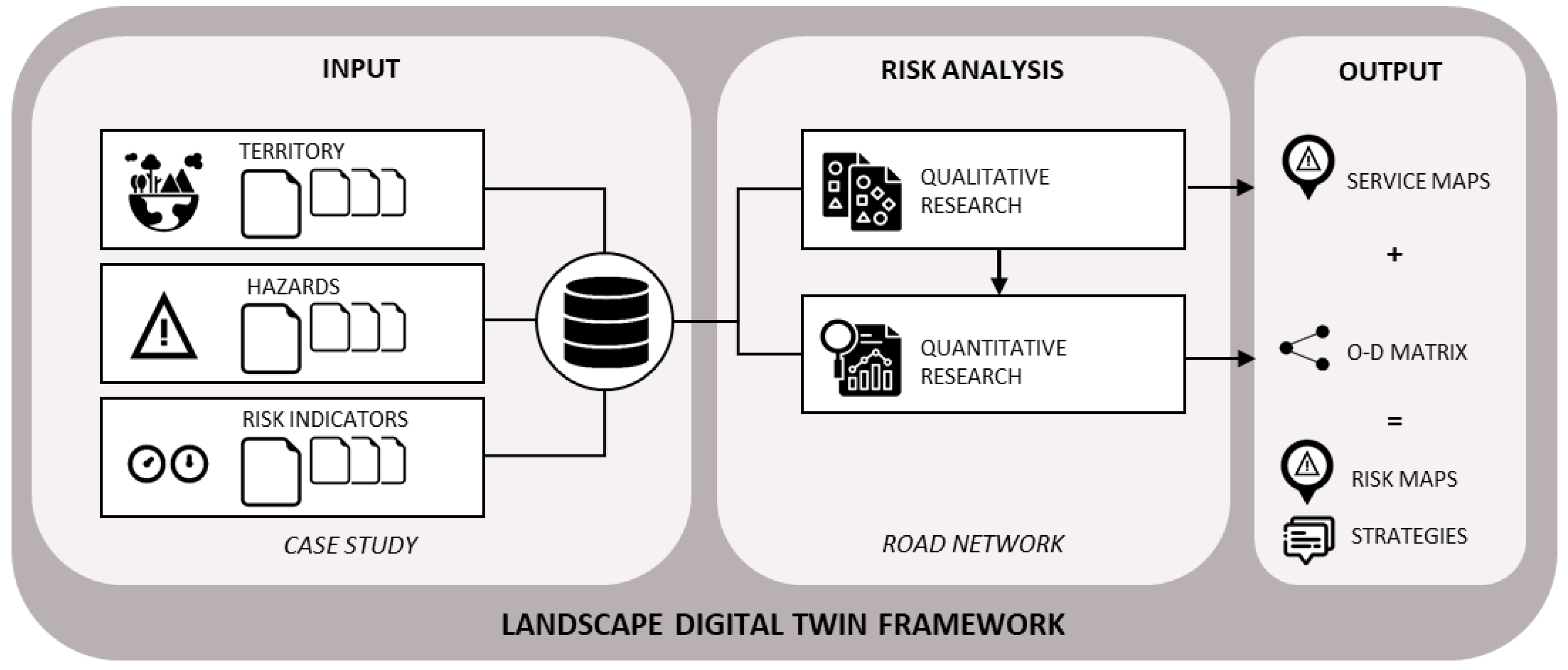
Figure 2.
Location of the study area and distribution in the five municipalities.
Figure 3.
Hydrogeological and landslide hazard mapping in the Orco Valley.
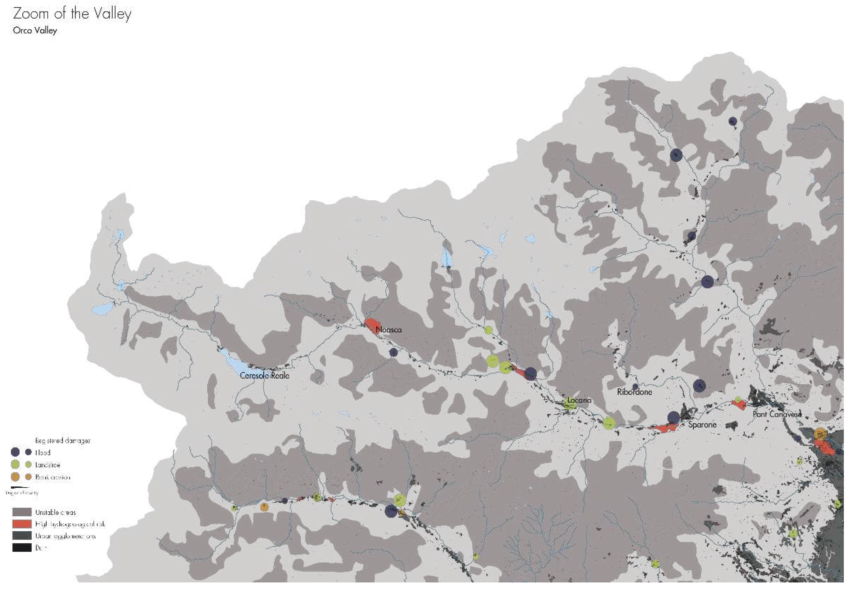
Figure 4.
Tourist and points of interest facilities located in the Orco Valley.
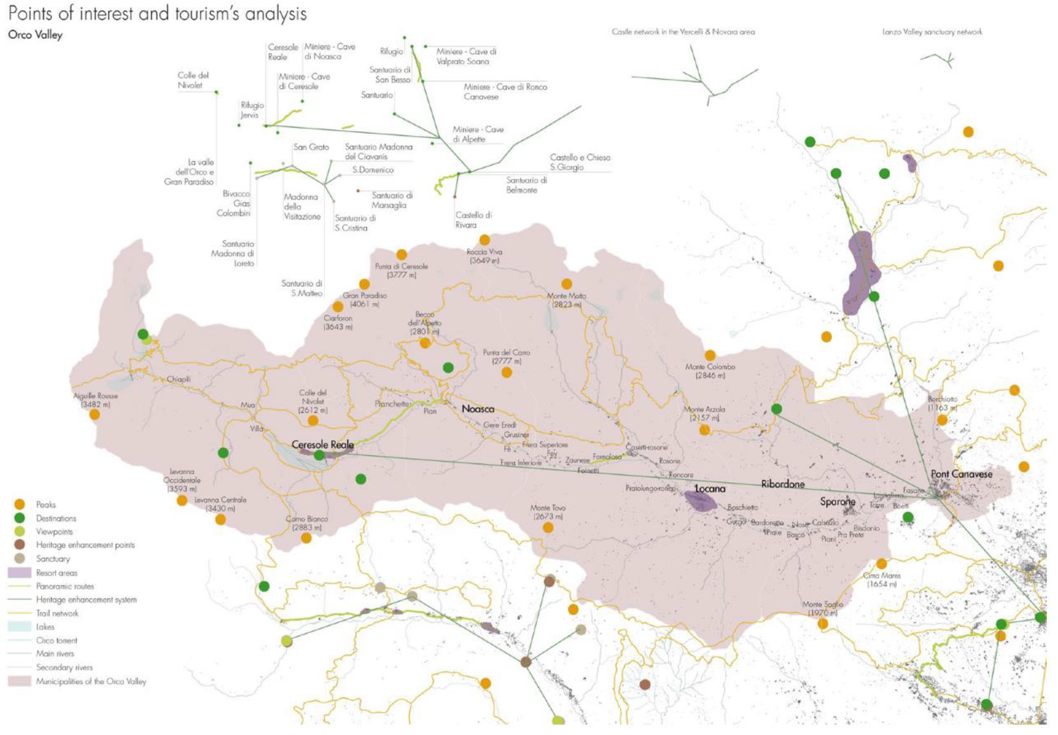
Figure 5.
Hazard maps of the case study area.
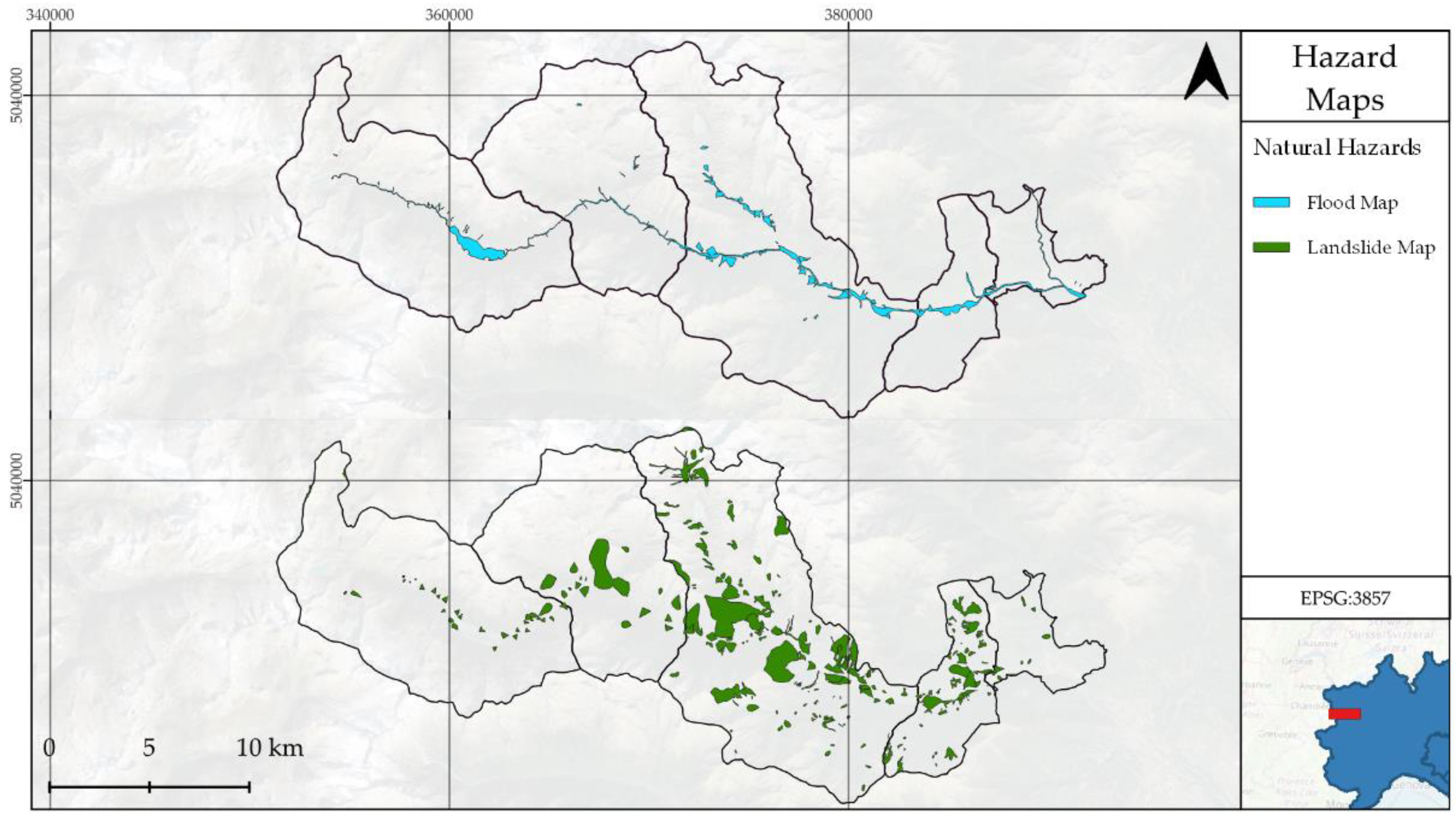
Figure 6.
Road network for the given case study.
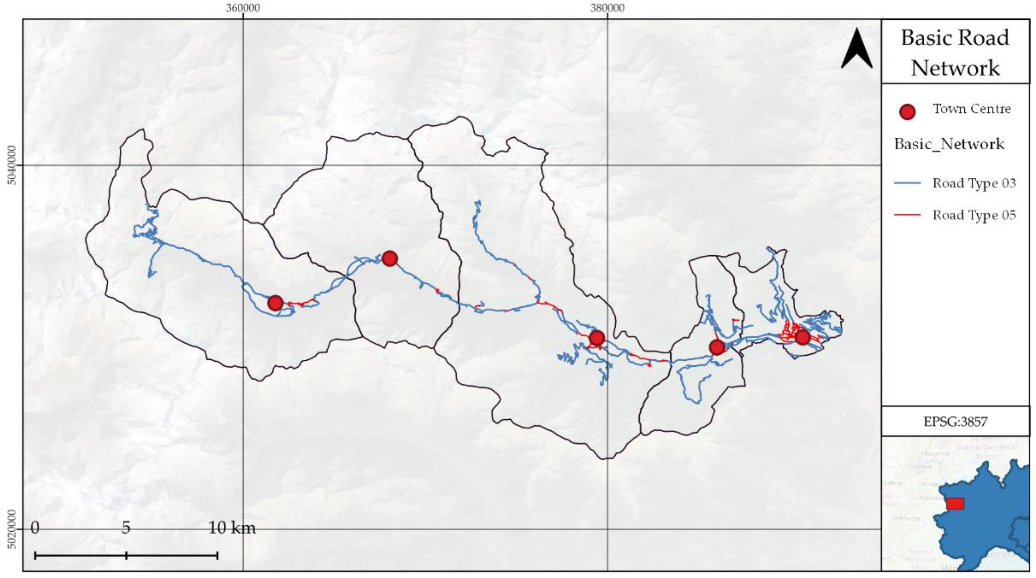
Figure 7.
Data layers inputted after integration.
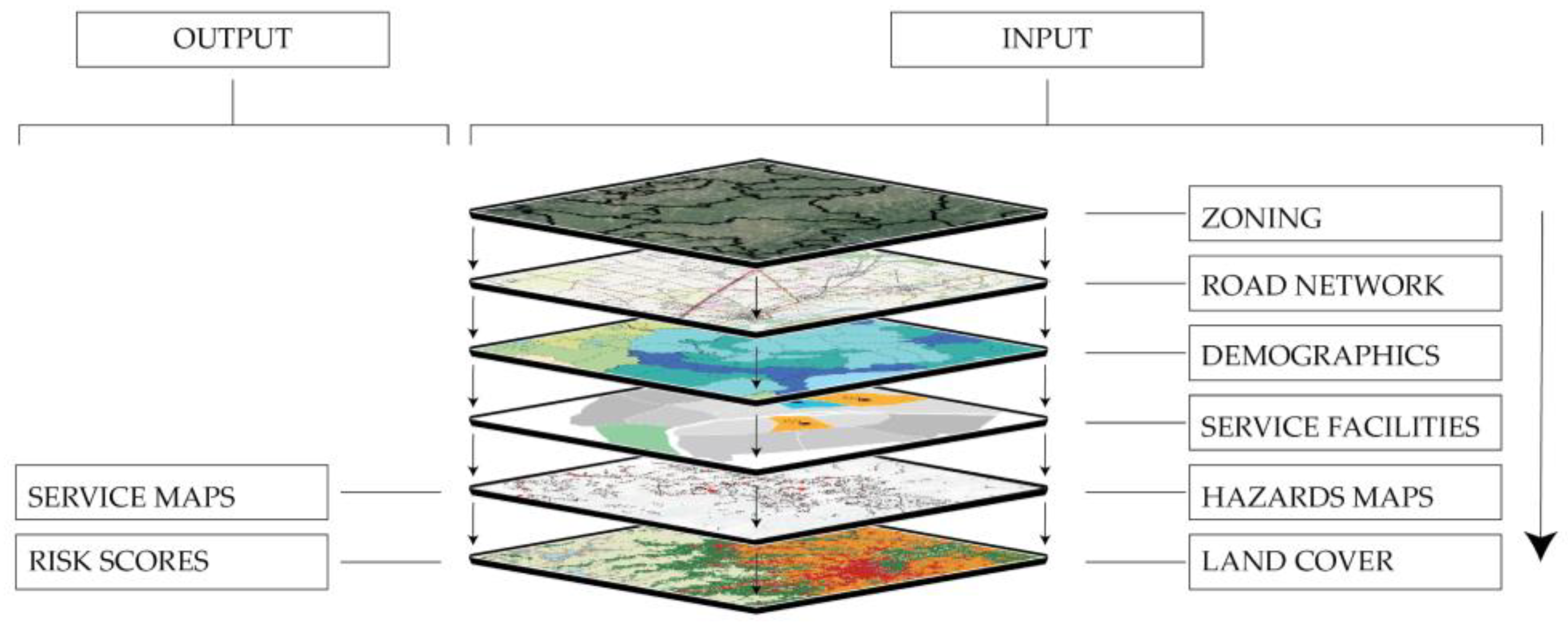
Figure 8.
Service maps for health facilities under different scenarios.
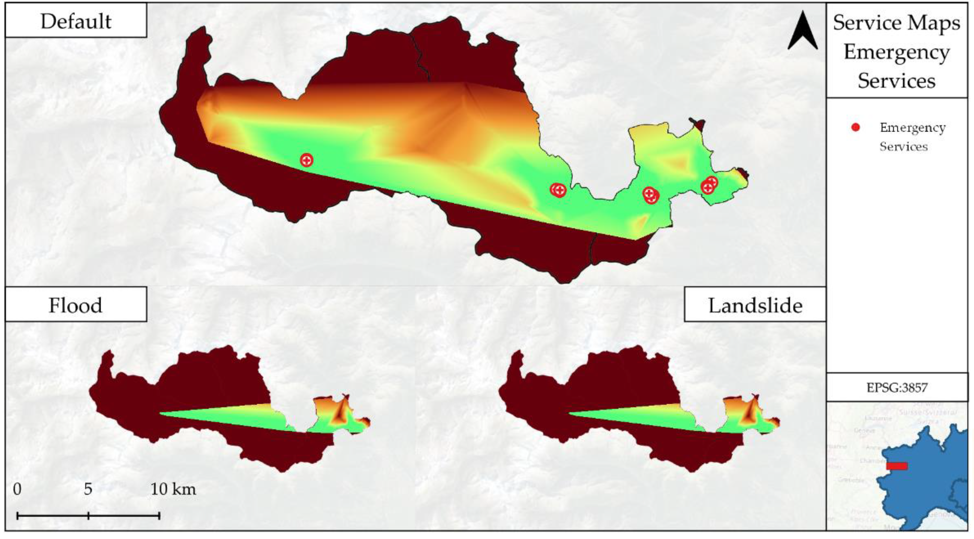
Figure 9.
Service maps for public facilities under different scenarios.
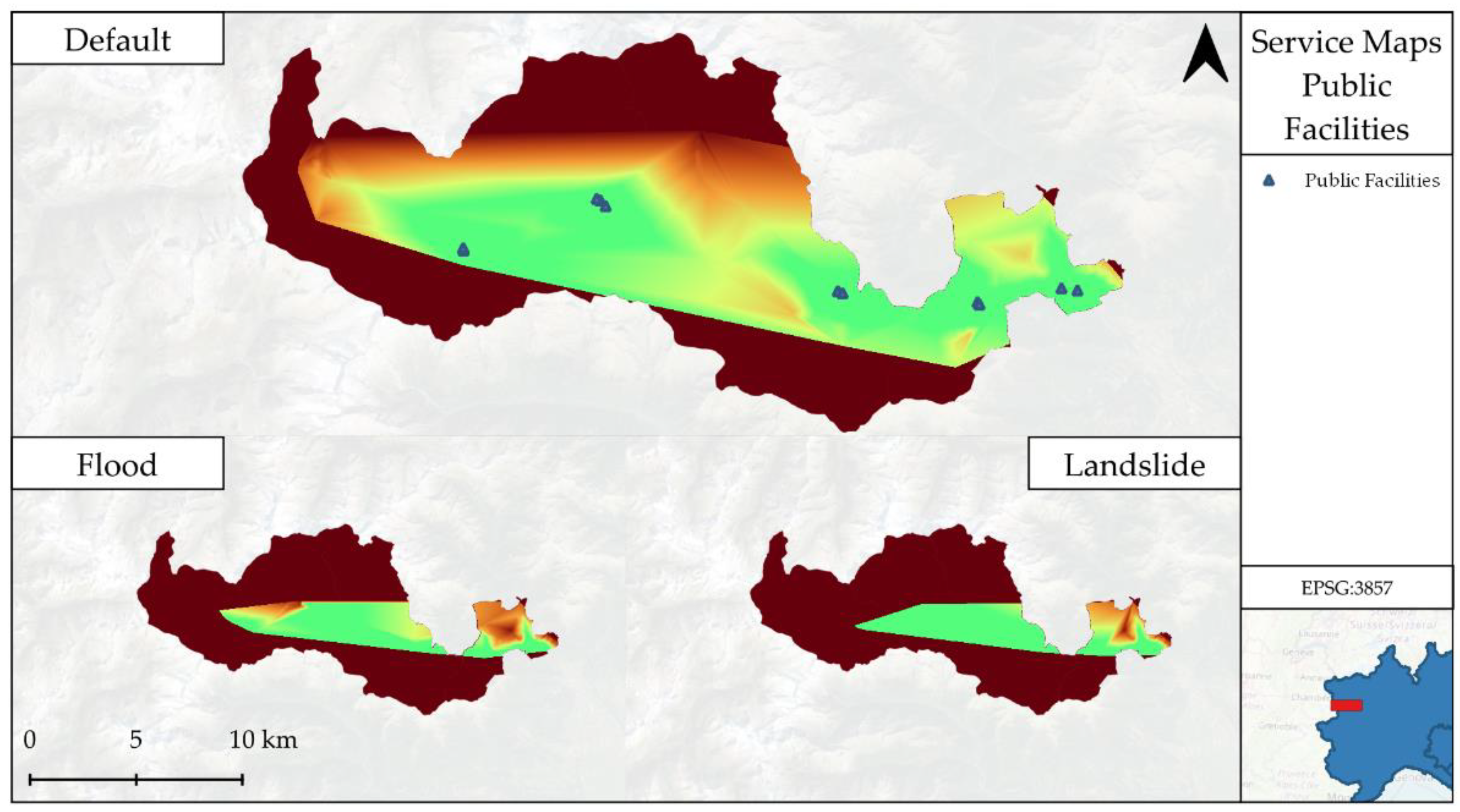
Figure 10.
Service maps for critical infrastructures under different scenarios.
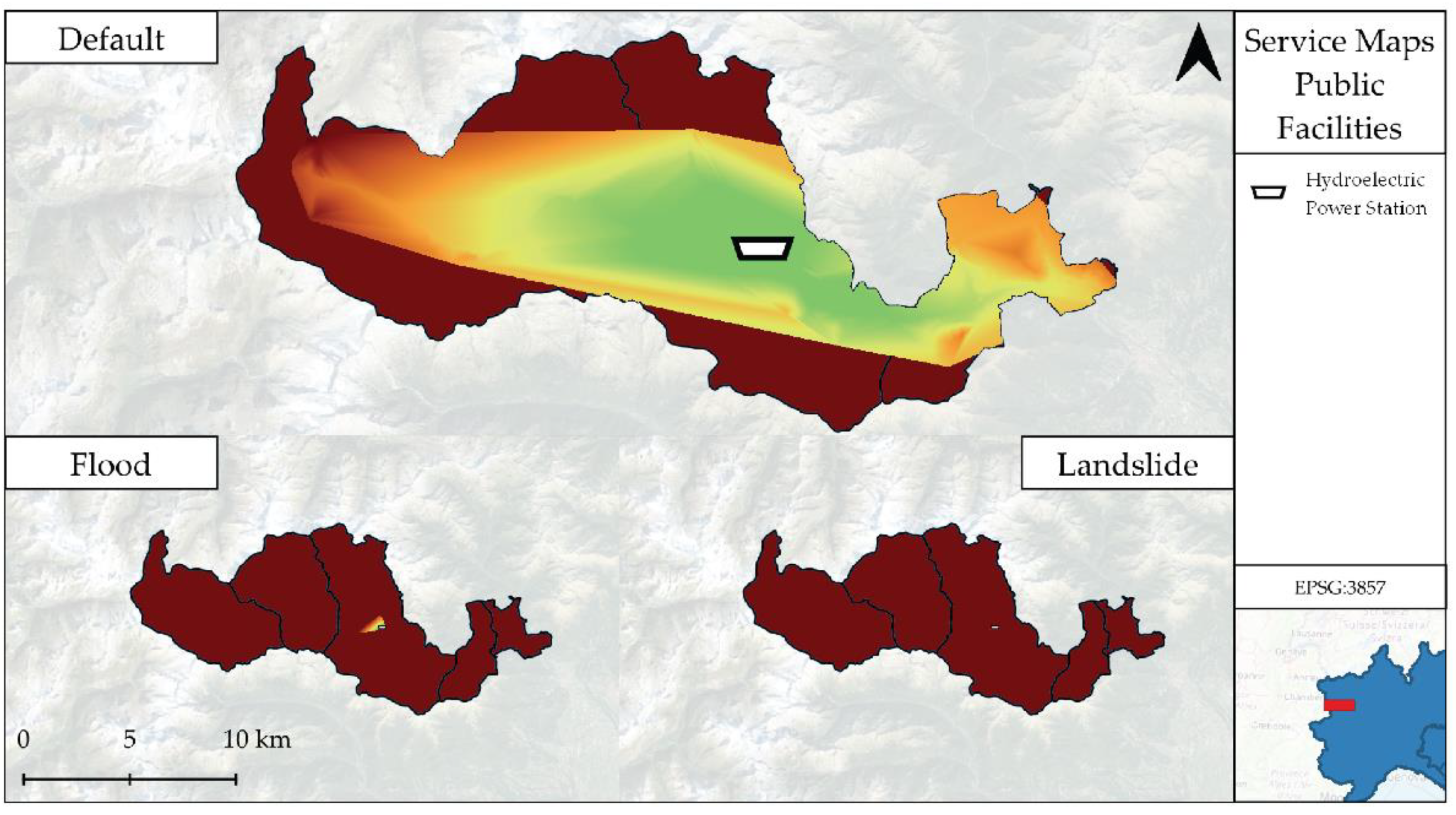
Figure 11.
Service maps for town centers under different scenarios.
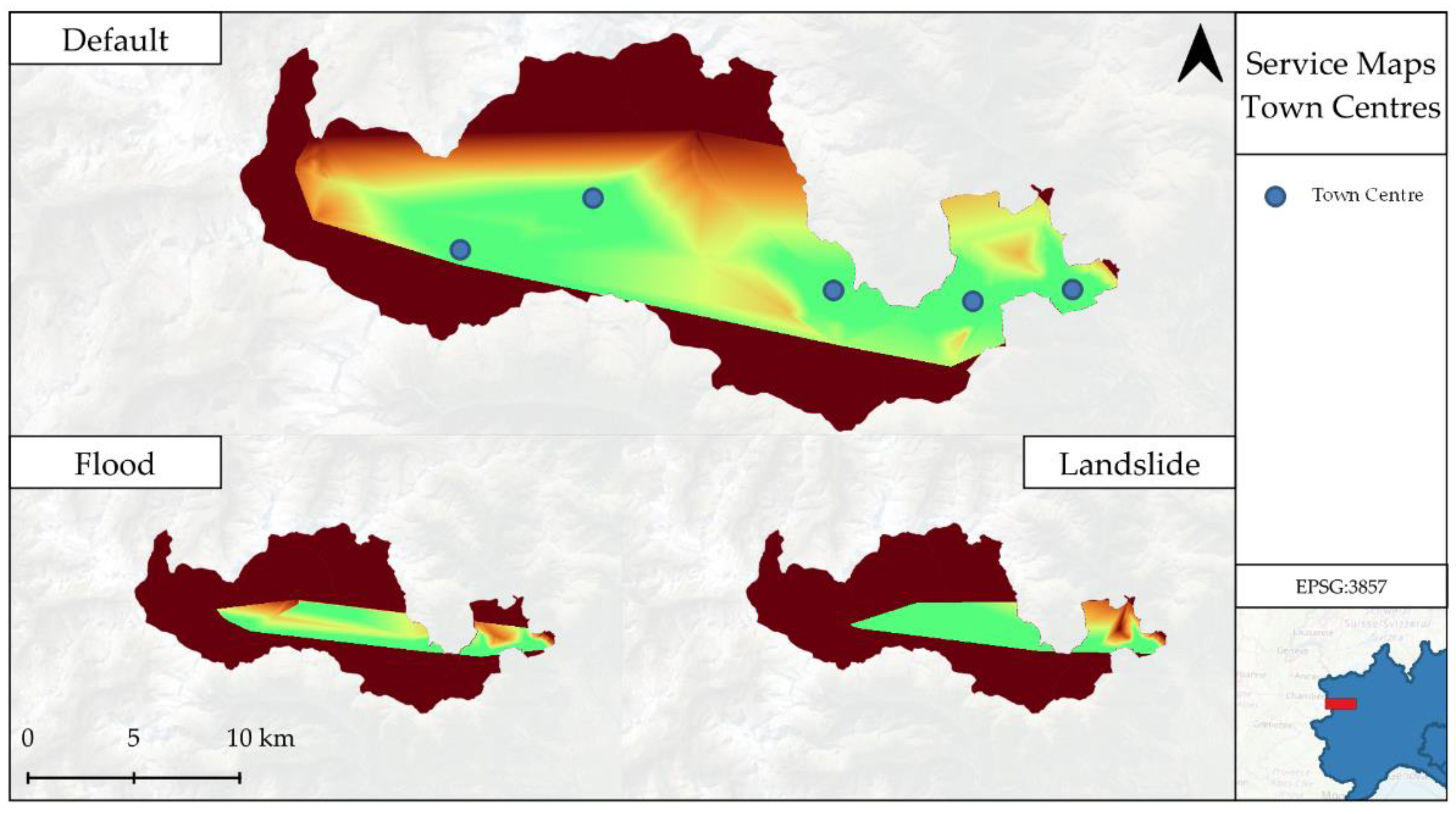
Figure 12.
(a) Service maps for tourism facilities under different scenarios. (b) Google Earth Snapshot of the critical node.
Figure 12.
(a) Service maps for tourism facilities under different scenarios. (b) Google Earth Snapshot of the critical node.
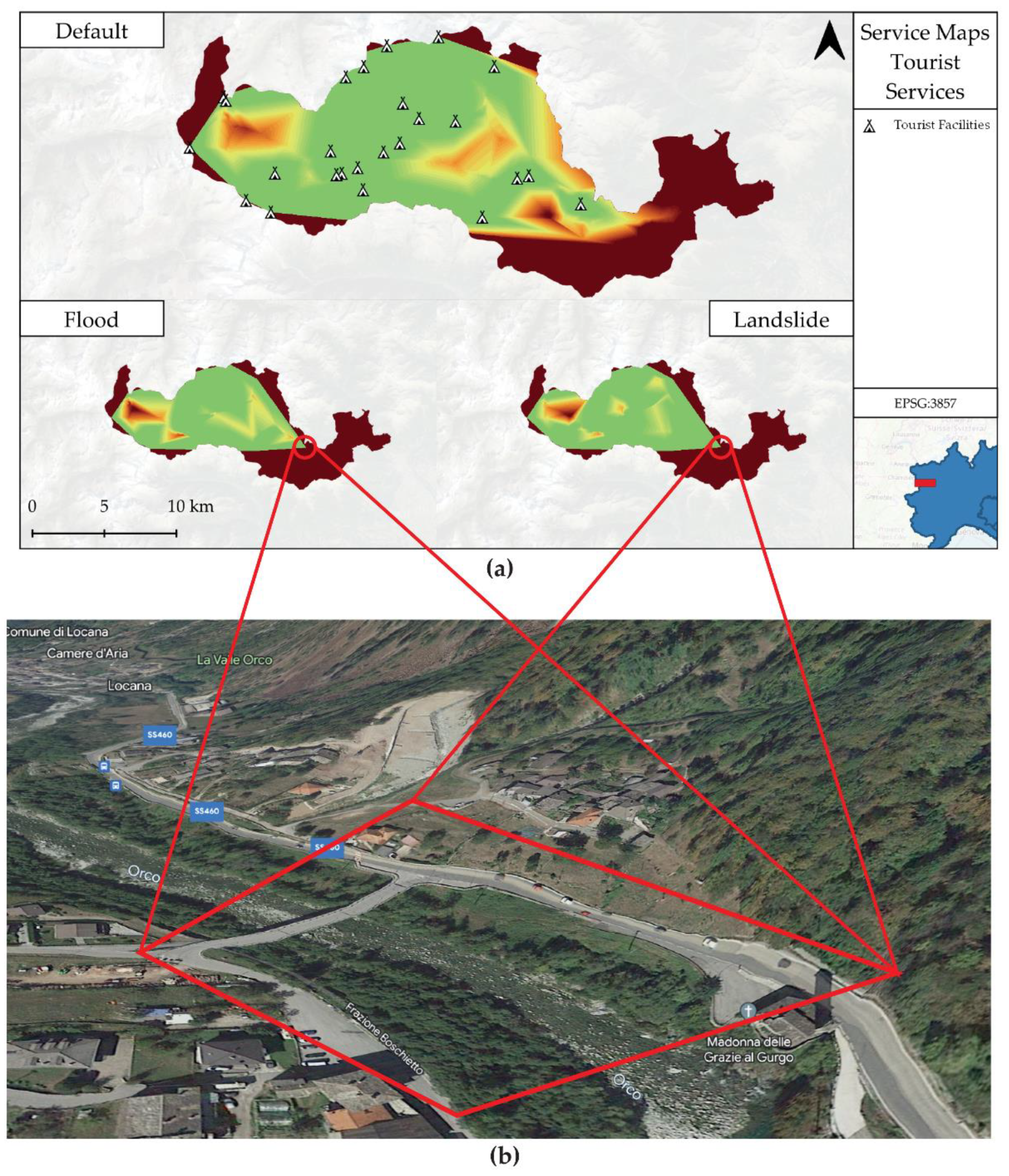
Figure 13.
O-D matrix graphs for health facilities under different scenarios.
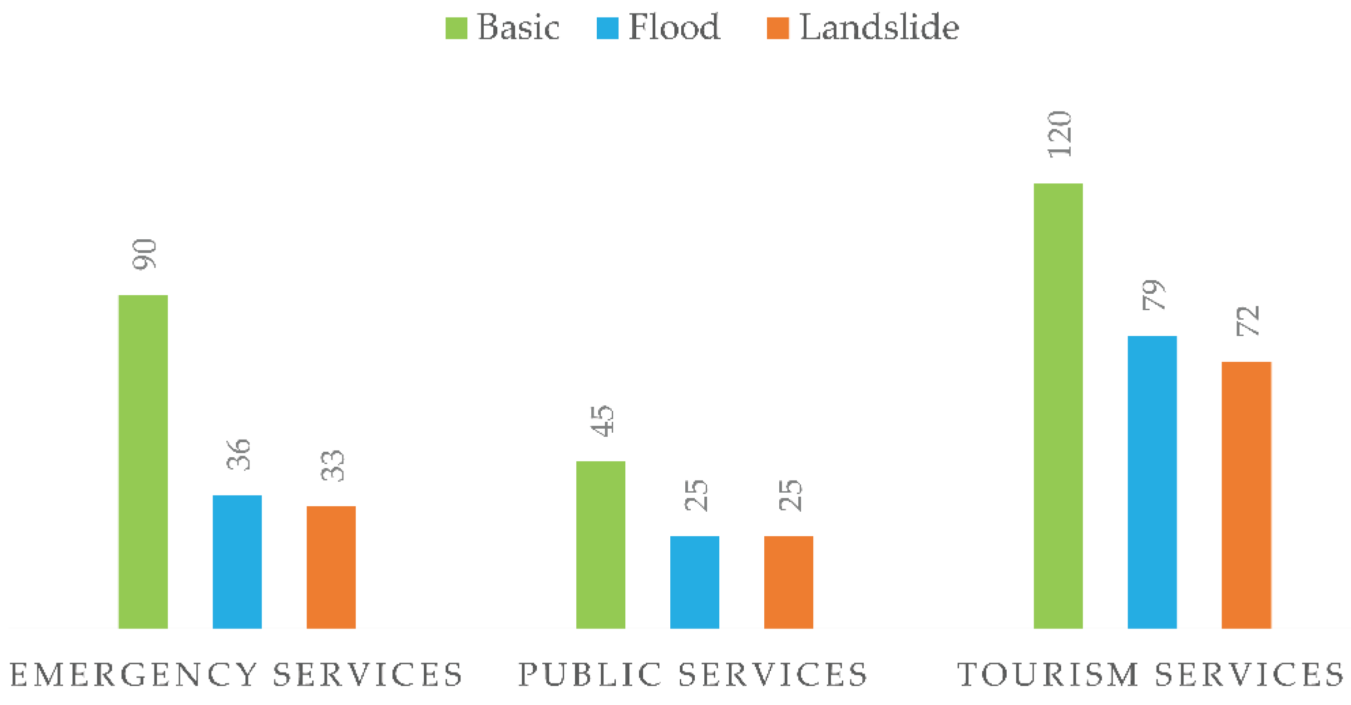
Figure 14.
Land cover classification map for the Orco Valley.
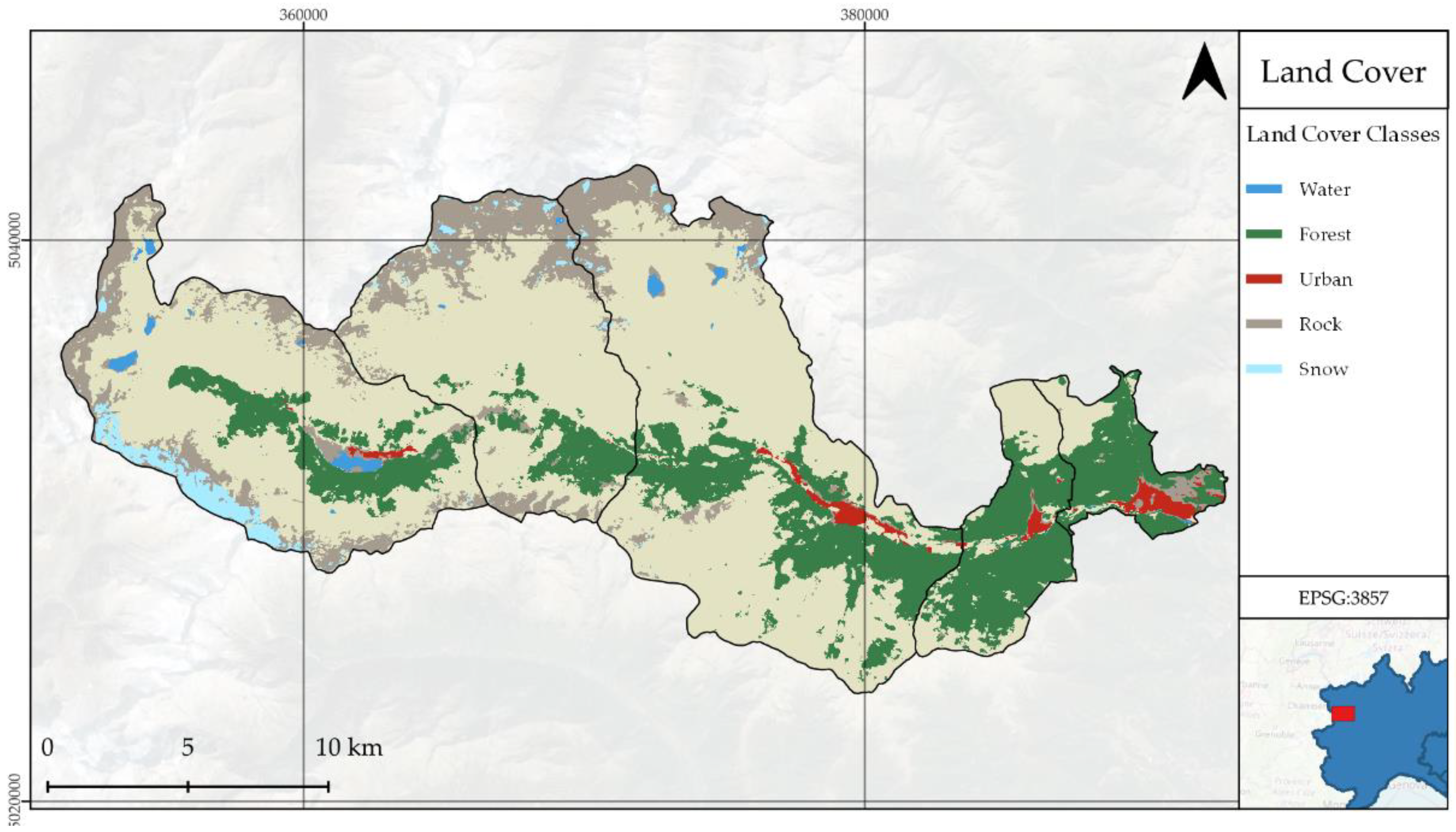
Figure 15.
Risk maps based on risk scores. (a) emergency services; (b) town centers; (c) public facilities; (d) tourism facilities; (e) hydroelectric power plant system.
Figure 15.
Risk maps based on risk scores. (a) emergency services; (b) town centers; (c) public facilities; (d) tourism facilities; (e) hydroelectric power plant system.
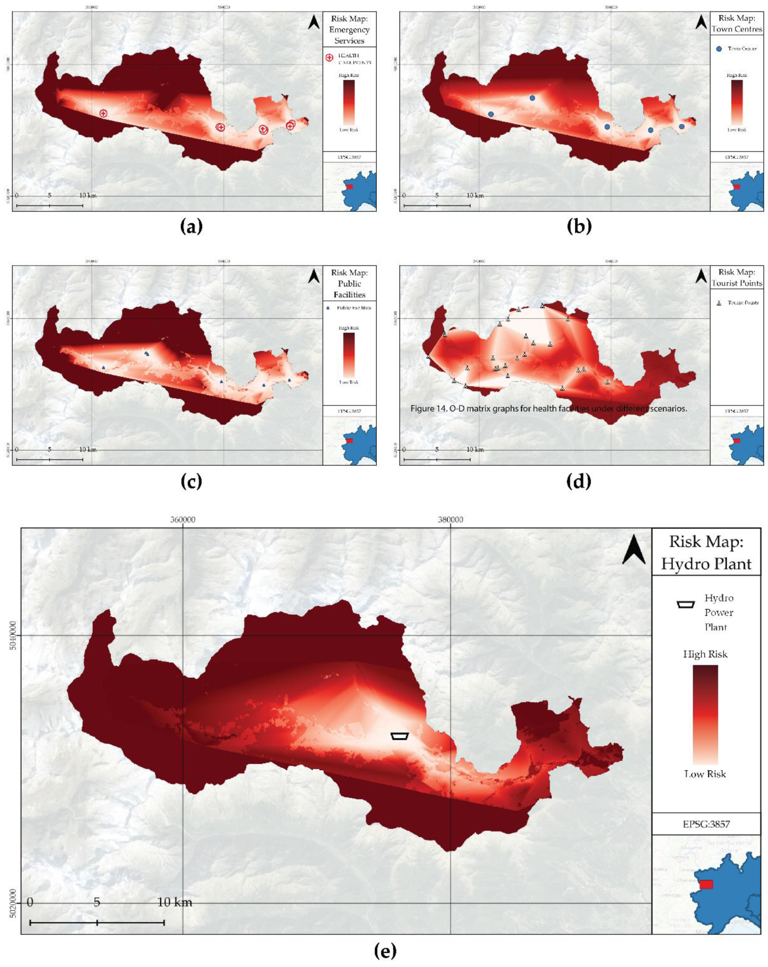
Figure 16.
Landscape digital twin architecture for multi-hazard risk analysis.
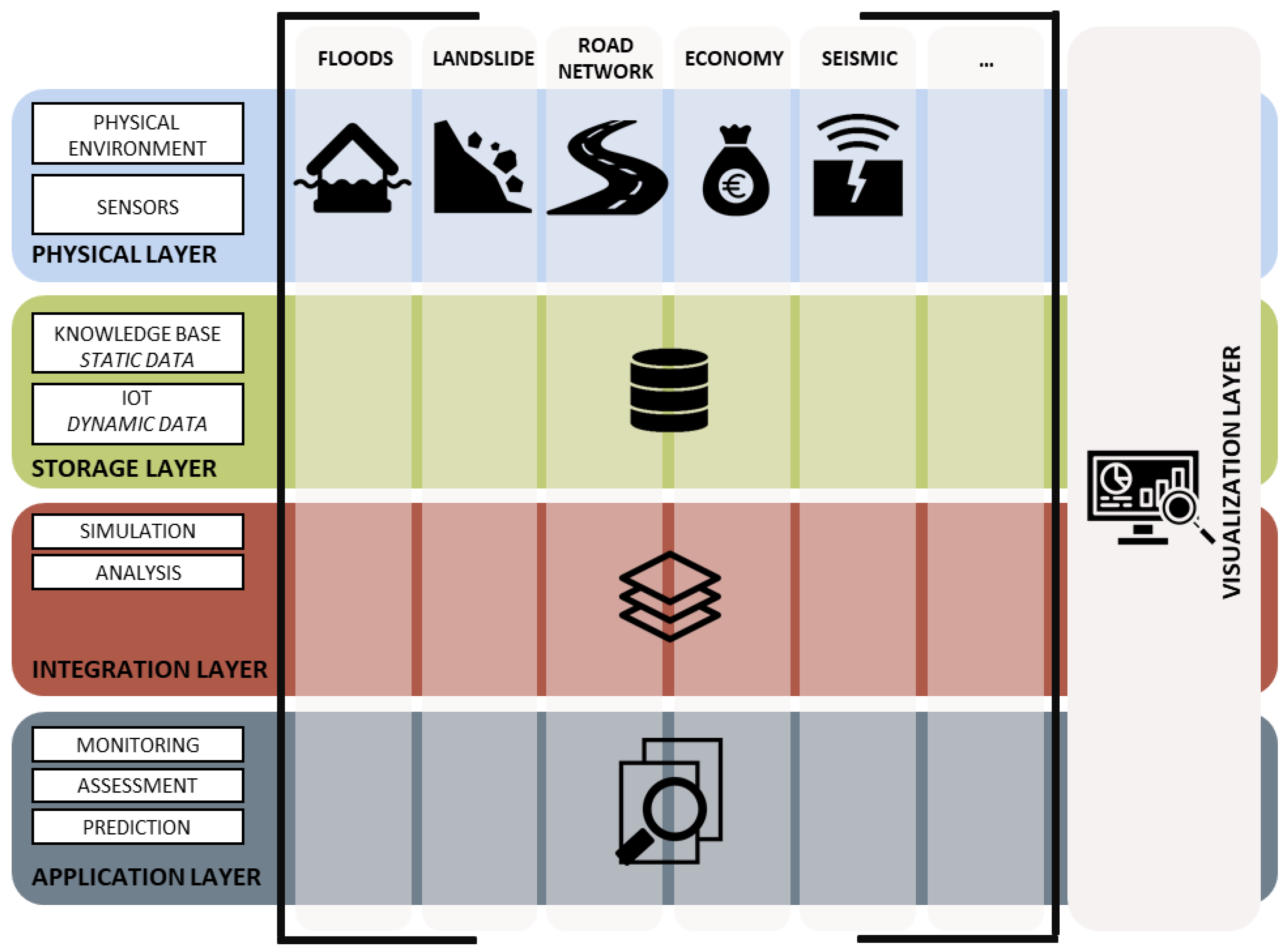
Figure 17.
Infraworks 3D visualization of the Orco Valley.
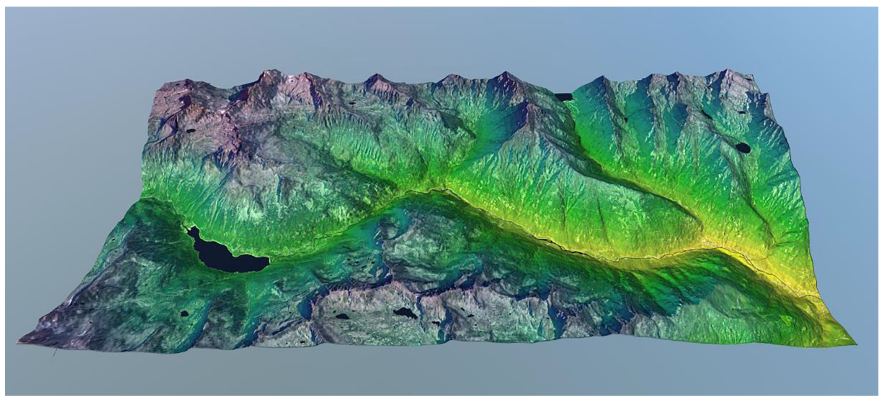
Figure 18.
Infraworks 3D Hazard Risk Maps visualization of the Orco Valley from GIS.
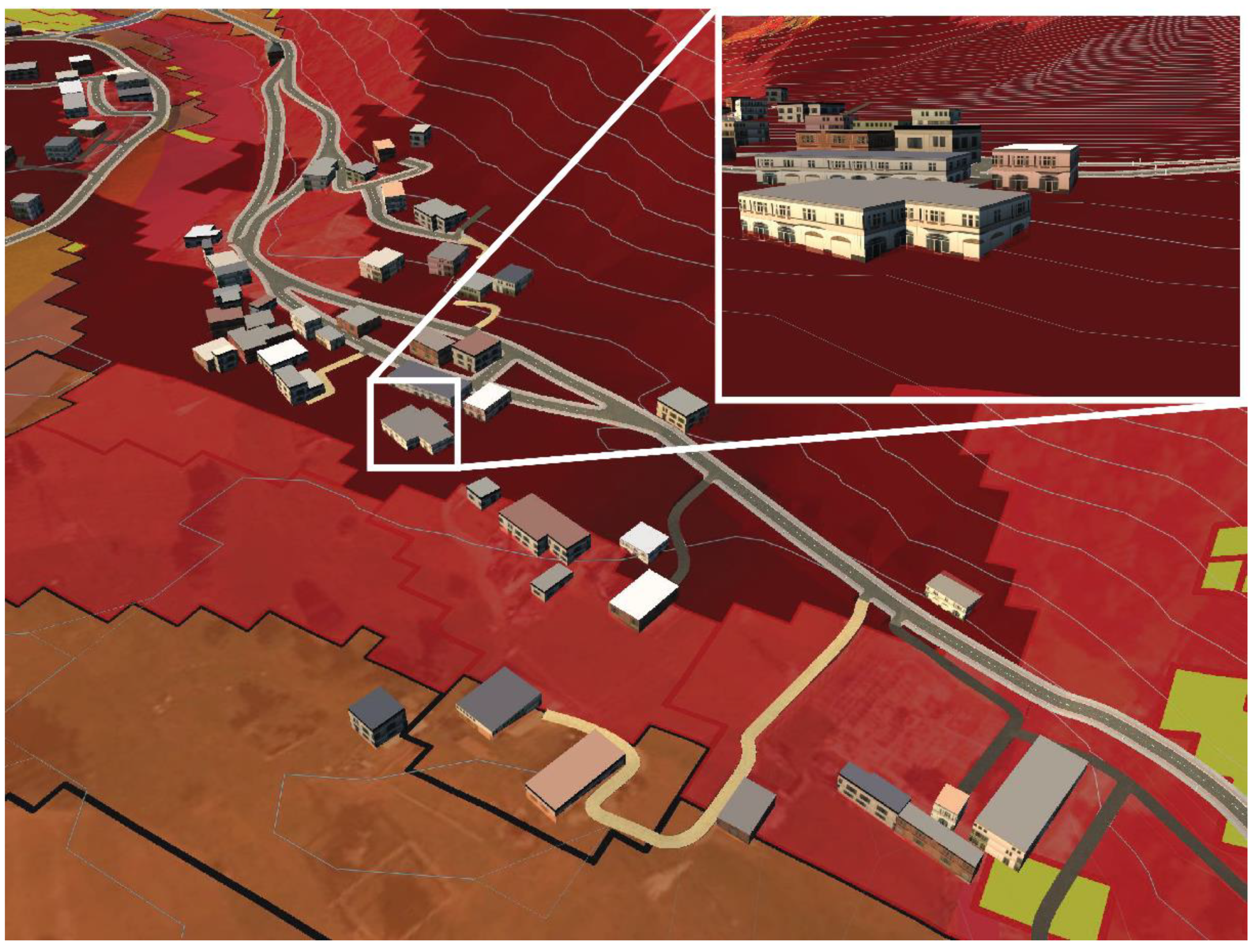
Table 1.
Data sources and types used for this study.
| Type | Source | Format | Details |
|---|---|---|---|
| Population | Piedmont Statistical Database | Tabular | Population statistics by commune [29] |
| Road network | ACI - Speed limit data | Vector | Road network map with speed limits by road type [32,33] |
| Commune boundaries | ISTAT - Administrative boundary data | Tabular | Commune boundary polygons with codes [34] |
| Hazard maps | ISPRA Open Data - Hazard data | Raster | Hazard maps for landslides and floods [35] |
| Points of interest (POIs) | National Geoportal - Public and private school dataset; Piedmont Geoportal - Healthcare building data; Piemonte Open Data Portal - Additional data sources; OpenStreetMap - QuickOSM | Vector | Points of interest for health facilities, public facilities, town centers, and tourism facilities [36,37,38,39] |
| Land use and land cover (LULC) | Copernicus Land Monitoring Service - CORINE Land Cover (CLC) | Raster | Land use and land cover map[40] |
| Monetary values | Literature review | Tabular | Monetary values for different types of assets [41,42] |
Disclaimer/Publisher’s Note: The statements, opinions and data contained in all publications are solely those of the individual author(s) and contributor(s) and not of MDPI and/or the editor(s). MDPI and/or the editor(s) disclaim responsibility for any injury to people or property resulting from any ideas, methods, instructions or products referred to in the content. |
© 2023 by the authors. Licensee MDPI, Basel, Switzerland. This article is an open access article distributed under the terms and conditions of the Creative Commons Attribution (CC BY) license (https://creativecommons.org/licenses/by/4.0/).
Copyright: This open access article is published under a Creative Commons CC BY 4.0 license, which permit the free download, distribution, and reuse, provided that the author and preprint are cited in any reuse.


