
Submitted:
11 April 2023
Posted:
12 April 2023
You are already at the latest version
Abstract
According to the Global Report on Internal Displacement (GRID, 2022), the number of displaced people worldwide at the end of 2021 was 59.1 million, with 53.2 million of them being the result of conflicts and violence, and 5.9 million caused by climate-related disasters. Furthermore, the In-ternational Organization for Migration (IOM) predicts that the climate crisis will be solely re-sponsible for one billion migrants by 2050. In this context, the research examines the issue of coastal multi-risk arising from a combination of heavy rainfall, river's overflow, and sea-level rise phenomena, analysing it through the disciplinary perspective of urban planning. Specifically, the study focuses on the need to upgrade the Local Urban Plan from a climate-proof perspective by defining a method aimed at updating the territory's cognitive framework through the preparation of a multi-risk map (which considers different time horizons), as well as the prescriptive apparatus of the Plan through the definition of a toolkit of site-specific design actions oriented towards urban adaptation. The proposed methodology is verified on the case study of Isola Sacra, Fiumicino (Italy), and it is intended to be applicable to other territorial contexts. The research aims to outline guidelines for updating urban planning tools from a climate-proof perspective to promote long-term resilient urban development in risk-prone areas.
Keywords:
climate-proof planning
; coastal multi-risk
; local urban plan
1. Introduction
1.1. Submerged Landscapes: The Impact of Climate Change on Coastal Territories
According to the Global Report on Internal Displacement [1], 59.1 million people were displaced globally by the end of 2021. Of this number, 53.2 million were displaced due to conflict and violence, while 5.9 million due to climate change-related disasters. Although it may seem that climate migration is on a smaller scale than that caused by conflict and political instability, the International Organisation for Migration (IOM) forecasts that the number of climate crisis migrants alone could reach one billion by 2050 [2].
In 2019, the Intergovernmental Panel on Climate Change [3] warned about the close relationship between extreme weather events, such as floods and droughts, and social and political instability. In the most extreme cases, these relationships can lead to armed conflicts. Thus, distinguishing between climate migration and migration caused by wars, hunger, or socio-economic marginalization will become increasingly difficult [4,5].
Indeed, even the European Union's New Pact on Migration and Asylum [6] acknowledges that the effects of climate change in developing countries will exacerbate the migratory phenomenon towards Europe [7,8].
According to the World Urbanization Prospects [9], 55% of the world's population currently lives in urban areas, and this figure is expected to increase to 68% by 2050 due to increased migration flows. This concentration of people and economic activities in cities will increase pressure on the urban environment, accelerating environmental degradation processes [10,11]. The United Nations' 2030 Agenda for Sustainable Development [12] recognizes that the impacts of climate change are transboundary and require a coordinated global response, which necessitates integrated approaches to risk management, sustainable planning, and design of urban settlements, prudent management of natural resources, and civil society awareness of the effects of climate change on cities and territories [13,14].
This research focuses on the issue of “coastal multi-risk”, which is the complex interaction of different factors caused by climate change. These include sea-level rise, coastal erosion, river's overflow, high tide phenomena caused by heavy rainfall, storm events, land subsidence, and the consequent loss of coastal habitats. These factors can interact with each other in complex ways, making risk management equally complex [15].
The European Environment Agency's report, Marine messages II. Navigating the course towards clean, healthy and productive seas through implementation of an ecosystem-based approach [16], highlighted how coastal multi-risk is set to increase in Europe due to the combined effect of climate change, population growth, migration, and urban development. This fact is also confirmed by the World City Report 2022 [17], and in the italian context by the document Report sulle condizioni di pericolosità da alluvione in Italia e indicatori di rischio associati [18], and by the 2021 Dossier I migranti ambientali. L’altra faccia della crisi climatica [19]. The first document shows that the threat is particularly serious for the delta areas of the Po, Adige, Arno, and Tiber; the latter document highlights that floods caused by river's overflow are also associated with the sea-level rise phenomena, a circumstance that will compromise the life of large and small coastal urban areas, in which storms will be increasingly frequent and cause serious damage, forcing the population to migrate to safer places.
The Italian Geographical Society's Conference of 30 January 2023 on “Submerged Landscapes” highlighted the criticality of Italy's coastal environments about erosion processes by 2050 and sea-level rise by 2100 as a consequence of climate change, expressing the need to devote the 2023 Annual Report, soon-to-be-published, to the topic.
The urgency of addressing the issue of coastal multi-risk from the disciplinary point of view of urban planning also emerges from reflecting on calamitous events that have impacted some of the world's major cities in recent years. These events have made it evident that there is a close relationship between spatial planning and the impacts of climate change, as recognized by experts and the general public [20,21]. Examples include Hurricane Sandy, which devastated much of Manhattan's southeast coast in 2012, and, in the Italian context, the storm that hit Venice in November 2019, as well as the disasters that affected the Marche region and the island of Ischia in 2022.
1.2. The “regulatory dimension” of territorial government tools
This contribution is contextualized within the research project Pianificazione climate-proof e strategie di rigenerazione per l’adattamento al fenomeno del sea-level rise. Sperimentazione e innovazione del Piano urbanistico locale nei territori a rischio del Lazio, financed by Sapienza - University of Rome (Principal Investigator Prof. Carmen Mariano). The project aims at investigating the theme of urban adaptation to the coastal multi-risk caused by climate change, in the territorial context of the Tiber estuary (Fiumicino, Italy), with a time horizon up to 2100.
Consistent with the authors’ research path on what they define as the “regulatory dimension” of the updating of territorial government tools from a climate-proof perspective [22,23], the results returned in this contribution propose some theoretical-methodological and operational references for the innovation of the Local Urban Plan from two closely connected points of view, the first (STEP 1), preparatory to the second (STEP 2):
- STEP 1 | Implementation of the territory’s cognitive framework through the preparation of a “multi-risk” map - with a time horizon to 2100 - concerning the consistency of floods caused by the concomitance of heavy rainfall and river’s overflow (transient and non-linear phenomena) and sea-level rise (stable and progressive phenomenon);
- STEP 2 | Definition of a toolkit of site-specific adaptation actions embedded in broader urban resilience strategies of “defence”, “adaptation” and “relocation” [24], complementing the prescriptive apparatus of the Local Urban Plan (STEP 2).
It should be noted that the interest of the research is not in multi-risk assessment, but rather in the definition of guidelines for the innovation of urban planning tools in the light of current knowledge on the impact of coastal flooding on the urban fabric.
2. Materials
2.1. Case Study
The proposed experimentation was conducted in the Municipality of Fiumicino, which was identified by Antonioli et al. (2017) [28] as one of the thirty-three Italian areas most at risk of flooding due to SLR by 2100. However, no urban or sectorial document provides information on the consistency of the areas at risk of flooding caused by this phenomenon. The Municipality of Fiumicino is also subject to floods caused by heavy rainfall that contributes in turn to the Tiber’s overflow. Unlike the risk of flooding from SLR, the one related to heavy rainfall and river’s overflow is included in a sectorial tool: Piano di Gestione del Rischio Alluvioni dell’Appennino Centrale (Flood Risk Management Plan of the Central Apennines) [29,30]. This plan proposes risk maps for three different temporal probability scenarios, including the low, medium, and high probability of flood events with return periods (RP) of 300 years, 100-150 years, and 30 years, respectively. The contribution focuses on the area known as “Isola Sacra” which has a specific geo-morphological conformation resulting from anthropic modifications dating back to the Claudian period, at the beginning of the 1st century A.D. [31]. The analysis specifically targets Area A - Passo della Sentinella (Figure 1), characterized by the presence of a spontaneous settlement built since the 1960s, where many people currently live despite the very high risk of flooding, which causes significant damage every year. Additionally, the Fiumicino Local Urban Plan [32] suggests the demolition of the existing building stock in this area and its relocation to geomorphologically safer areas to facilitate environmental reclamation operations (Figure 2).
Regarding the three macro-strategies of urban resilience to climate change, which were previously conceptualized by the authors in their joint research activity as “defence”, “adaptation” and “relocation” [24], the Fiumicino Municipality's Administration is currently only undertaking actions related to the “defence” strategy. This is being done through the construction of massive embankments to protect the most vulnerable areas. However, it should be noted that these interventions completely disregard any communication, even visual, between the urbanized areas and the natural element (the river), which has a negative impact on the place’s identity (Figure 3).
An example of this approach is the construction of the “embankment road” that demarcates Target Area A - Passo della Sentinella to the north, northeast and east. This imposing embankment protects the most vulnerable area of Isola Sacra, which is the area closest to the mouth of the Tiber River (Figure 4), but at the same time it also isolates the settlement of “Passo della Sentinella” even further, thereby negatively impacting the effects of future floods in that area. In the event of a flood, the embankment road will further impair the already difficult outflow of excess water, leading to a “pool effect” in the target area.
This intervention underscores the fact that the definition of “defence”, “adaptation” and “relocation” actions must be planned while considering the complexity of the urban context. This operation requires coordination managed within the urban planning tool at the local level. Hence, the latter should provide a clear territory's cognitive framework concerning risk phenomena and prescriptions in line with the future scenarios profiled.
For the experimentation, the following materials were used, some of which are described in the following paragraphs:
2.2. PRG of the Municipality of Fiumicino
Fiumicino became an autonomous municipality in 1992, prior to which it was included in the municipal territory of Rome, and its administrative boundaries were part of the 1962 General Regulatory Plan (PRG) of the Municipality of Rome. The first General Regulatory Plan of the Municipality of Fiumicino was not implemented until 2006, which meant that from 1992 to 2006, Fiumicino lacked clear indications for urban planning. This peculiarity, along with the illegal construction that affected the entire Italian territory in the 1970s, contributed to the proliferation of spontaneous and unauthorized settlements, which were often in contrast with the provisions of Rome's 1962 PRG. These irregularities were acknowledged and rectified by the 2006 Fiumicino Plan.
One example of this was the spontaneous settlement of “Passo della Sentinella”. The Rome Plan of 1962 designated this area as a “public park” (Figure 5a) due to its extreme vulnerability to flooding phenomena, caused by its position at the mouth of the Tiber River. However, the current PRG of Fiumicino (2006) classifies it as Zone B or “completion: consolidated residential building” – Sub-zone B1b, or “building maintenance for environmental reclamation and restoration” (Figure 5b).
The shape file of Fiumicino's PRG [32], which divides the plan into Homogeneous Territorial Zones, was used for experimentation. Homogeneous Territorial Zones are the areas into which a municipal territory is divided in Italy, as part of the zoning carried out in local urban planning instruments. These zones are grouped by affinity, and each has different prescriptions according to the peculiarities of the area.
Homogeneous Territorial Zones were formally introduced by Law no. 765 of 6 August 1967 and further regulated by Ministerial Decree no. 1444 of 2 April 1968. These zones include:
- Zone A: historic center, historic buildings;
- Zone B: completion zone, consolidated residential building;
- Zone C: expansion housing;
- Zone D: zone for productive settlements;
- Zone E: agricultural area;
- Zone F: zone for collective facilities and equipment.
Each zone is further divided into different sub-zones, with different prescriptions given for each of these.
2.3. PGRAAC risk maps
The shape files, which were prepared by the Central Apennine District Basin Authority in the Piano di Gestione del Rischio Alluvioni dell’Appennino Centrale (Flood Risk Management Plan of the Central Apennines) [29,30], were utilized to verify the consistency of the areas at risk of flooding with RP 30 and 100 years. The risk maps depict the risk of flooding under three distinct probability scenarios:
- a)
- low probability or extreme event scenarios
- b)
- average probability of flooding
- c)
- high probability of flooding
With regards to this, Italian Legislative Decree 49/2010, which implements the national Floods Directive, establishes that high probability scenarios or frequent floods correspond to return periods between 20 and 50 years (for scenario c = Tr ≤ 30 years), whereas medium probability scenarios or infrequent floods correspond to return periods between 100 and 200 years (for scenario b = Tr ≤ 150 years). Therefore, low probability or extreme event scenarios are those corresponding to return periods exceeding 200 years (for scenario a = Tr ≤ 300 years) [29,30].
It should be emphasized that the Target Area, is entirely impacted by high-probability flooding phenomena with frequent flooding (RP 30). In Figure 6, the color yellow represents the high risk (frequent floods), orange represents the medium risk (infrequent floods), and brown represents the low risk (rare floods).
2.4. SLR projections to 2100
Regarding the SLR phenomenon, the study takes into account projection data of the average Mediterranean sea-level rise up to 2100 [34]. It is important to note that the authors do not delve into the details of how the projection data are defined, which is the responsibility of climate modeling. Instead, these projections represent a reference to understanding how these can be related to the forecasts of the Local Urban Plan. This is done in order to update both the territory's cognitive framework concerning future risk scenarios (as far as the indicative apparatus is concerned) and the prescriptive apparatus by proposing site-specific adaptation actions compatible with the risk scenario, as integrations of the Technical Implementation Regulations (in Italian: Norme Tecniche di Attuazione – NTA).
It is worth noting that the use of such data has a purely demonstrative purpose and would change little for this research, even if fluctuations in sea-level rise in the order of a few centimeters were recorded. This is because, as specified in the introduction, the purpose of the experimentation is not the assessment of multi-risk, but the definition of guidelines for the innovation of the urban planning tool in light of current knowledge on the impact of coastal flooding on the urban settlement.
Before delving into the specifics of the study, it is important to note that SLR is one of the most impactful effects on the territory related to climate change. In this sense, the text underlying the definition of sea-level rise projections to 2100 is the Fifth IPCC Report of 2013 (hereinafter AR5) [36], taking into account the updates published in the AR6 (IPCC, 2021) [37] which represents the current state of knowledge on climate change and its potential environmental and socio-economic impacts.
The basic data from which to encode projections of rising global temperatures and consequent sea-level rise are the so-called “emission scenarios”: plausible representations of the future development of greenhouse gas and aerosol concentrations. In AR5, four new scenarios, called RCPs (Representative Concentration Pathways), were used. These scenarios indicate a representative trend in greenhouse gas and aerosol concentrations for a given climate target (in terms of radiative forcing in 2100), which in turn corresponds to a given trend in human emissions [38,39,40].
The RCP scenarios considered are as follows:
- RCP 2.6 mitigation scenario (very high emission reduction);
- RCP 4.5 stabilization scenario (large reductions);
- CPR 6.0 stabilization scenario (mild reductions);
- RCP 8.5 high emission scenario (“business as usual”).
For the study, the elevation figure used is the average for the Mediterranean Sea, which is approximately 63 cm compared to the RCP 8.5 scenario [34].
3. Methodology
3.1. STEP 1: Integration of the territory's cognitive framework concerning the risk of flooding due to heavy rainfall and river’s overflow and sea-level rise phenomena
First, it was necessary to develop a SLR (Sea Level Rise) risk map with a time horizon of 2100, using the methodology previously elaborated by the authors [23,41]. To accomplish this, contour lines were extracted from the DEM (Digital Elevation Model) with a resolution of 10 meters [33] using the Q-GIS 3.10.2 software. The contour line at an elevation of 63 cm [34] was isolated, which represents the projection of the coastline at 2100. The shape file of the Fiumicino PRG (2006) was then edited to highlight the Homogeneous sub-zones included in the target area A - Passo della Sentinella (Figure 7). The specifications of these sub-zones are described in Table 1.
Next, the previously obtained projection of the coastline to 2100 was superimposed, and the percentages of homogeneous zones potentially affected by flooding by 2100 due to sea-level rise were determined using a quantity-qualitative reading, as described in the section on STEP 1 results (section 4.1) (Figure 8).
After defining the flood risk by 2100 caused by a sea-level rise of 63 cm, the risk relative to flood caused by heavy rainfall and river’s overflow phenomena was defined. The shape files of the PGRAAC risk maps [29,30] with 30-year RP (Return Period) and 100-year RP, which are coincident for the target area A - Passo della Sentinella (Figure 9), were superimposed on the Fiumicino PRG (2006) [32]. Similarly to what was done for the SLR phenomenon, the percentages of Homogeneous zones involved and affected by flooding with 30-year and 100-year RP were determined using a quantity-qualitative reading, as described in the paragraph on the STEP 1 results (paragraph 4.1).
Finally, by superimposing the consistency of the SLR risk areas and the area at risk of flooding due to heavy rainfall and river’s foverflow with RP 30 and 100 years, it can be seen that the entire Target Area A - Passo della Sentinella is affected by flooding with a time horizon of 2100 (Figure 10).
3.2. STEP 2: Definition of the site-specific action toolkit for the risk of flooding caused by heavy rainfall and river’s overflow and sea-level rise phenomena
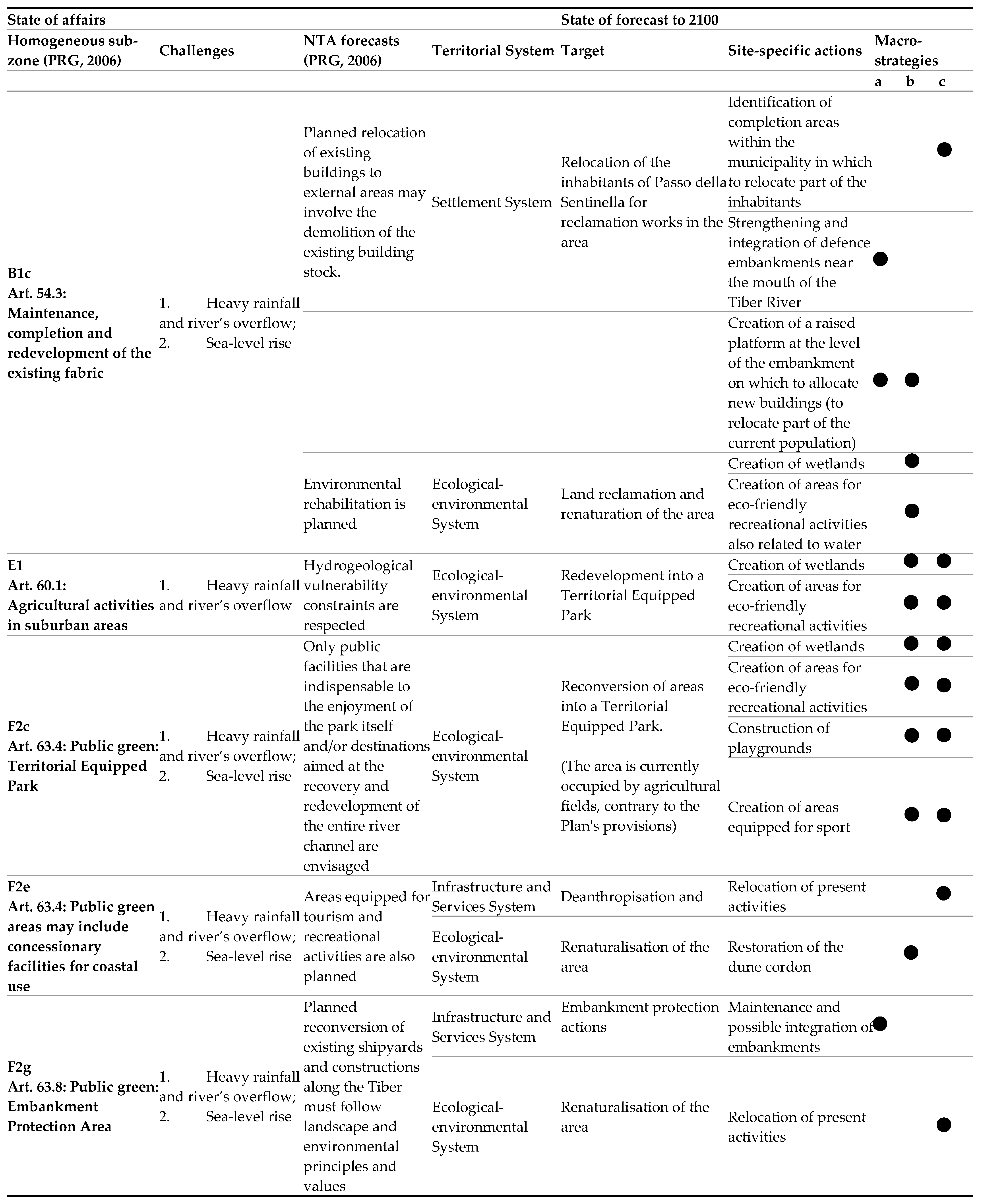
The authors have been working for several years on the definition of macro-strategies and design actions for climate-adaptation, first defining the three macro-strategies of urban resilience, named “defence”, “adaptation”, “relocation” [24], then a toolkit of site-specific design actions that relates the design actions [42,43,44,45,46] with the systemic components that make up the urban structure [47,48,49,50,51,52,53,54,55,56,57]. For this work, the methodology conceptualised by the authors has been augmented and updated and includes the explication of:
- a “state of affairs”, which considers the current Local Plan forecasts for the Homogeneous sub-zones included in the Target Area;
- a “state of forecast to 2100”, with a 100-year time horizon, which validates or supplements the forecasts currently in force for those areas, to provide indications for the future updating of the Plan in the light of the risk highlighted by the multi-risk maps of the area obtained in "STEP 1".
In the “state of affairs” the following are made explicit:
- the Homogeneous sub-zones within the Target Area;
- the challenges affecting the reference sub-zones to which the adaptation action must respond (in this case heavy rainfall and river's overflow, and sea-level rise);
- the forecasts (currently in force) indicated in the NTAs of the Plan for each homogeneous sub-zones;
- the physical-territorial system most affected by the risk phenomenon and therefore the one that will receive the greatest benefits from adaptation action: the Ecological-environmental System, the Settlement System, the Infrastructure and Services System.
In the “state of forecast to 2100”, the following are made explicit:
- some targets (i.e. the adaptation goals to be achieved in the light of the flood risk);
- several site-specific actions (each of which will refer to a reference macro-strategy: “defence”, “adaptation”, or “relocation”) to be sought (during the project phase) in best practices with similar characteristics to the area under study).
The methodology for constructing the toolkit is designed to be exportable and replicable in different contexts and includes the possibility of being integrated according to circumstances.
The results of the application of the toolkit to Target Area A - Passo della Sentinella are presented in the STEP 2 results section (section 4.2).
4. Discussion and Results
4.1. STEP 1 | Quanti-Qualitative Reading of Sub-zones at Risk of Flooding due to Heavy Rainfall and River’s Overflow, and Sea-level Rise
Thanks to the methodology presented in STEP 1 (paragraph 3.1), it was possible to perform a quanti-qualitative reading of the flood risk at 2100 caused by a predicted sea-level rise of 63 cm. The table below shows the percentage of the area at risk of flooding, with respect to the area of the reference sub-zone included in Target Area A – Passo della Sentinella (Table 2).
It follows that the sub-zone B1c, which pertains to the "Maintenance, Completion, and Redevelopment of Existing Buildings", would be affected by flooding due to SLR at 2100 for approximately 59.81% of its area. The sub-zone F2c, designated as a "Public Green: Equipped Territorial Park" (currently occupied by agricultural fields, in violation of current regulations), would be affected for about 14.81% of its area. The sub-zone F2e, classified as a "Public Green: Concessionary Facilities for the Enjoyment of the Coast," would be entirely affected within the target area. The sub-zone F2g, designated as a "Public Green: Embankment Protection Area," would be affected for approximately 81.84% of its area. However, the area of sub-zone E1, which pertains to "Agricultural Activities in the Extra-Urban Territory" and is included in the target area, would not be compromised due to flooding at SLR to 2100 (see Table 2).
Similarly, it was possible to perform a quanti-qualitative reading of the expected floods due to heavy rainfall and river’s overflow with RP 30 years and RP 100 years. As previously stated, these two phenomena coincide in the target area. The table below shows the percentage of sub-zones at risk of flooding included in the Target Area A - Passo della Sentinella (Table 3).
As a result, sub-zone B1c, which pertains to the "Maintenance, Completion, and Redevelopment of Existing Tissue," would be affected by flooding with RP 30 years and RP 100 years for approximately 76.69% of its area. Sub-zone E1, which pertains to "Agricultural Activities in the Extra-Urban Territory" and is included in the target area, would be entirely affected. The sub-zone F2c, designated as a "Public Green: Equipped Territorial Park" (and is currently occupied by agricultural fields, in violation of the Plan's regulations), would be affected for approximately 98.02% of its area. The sub-zone F2e, classified as a "Public Green: Facilities under Concession for the Enjoyment of the Coast," would be affected for about 55.44% of its area. Finally, sub-zone F2g, designated as a "Public Green: Embankment Protection Area," would be affected by approximately 36.12% of its area (see Table 3).
4.2. STEP 2: Application of the toolkit to Target Area A – passo della Sentinella
After completing the quanti-qualitative reading of Table 2 and Table 3, it was possible to conduct specific evaluations on the current prescriptions of the Fiumicino Local Plan (NTA), which is currently in force (refer to Table 1). These evaluations will provide useful indications to the Local Administration for updating the Plan in accordance with the risk scenarios outlined in STEP 1.
As outlined in the STEP 2 methodology (section 3.2), the toolkit (Tab.4) includes:
- a “state of affairs” that illustrates the current NTA prescriptions for the relevant sub-zones within the target area, the risk scenario they face (determined in STEP 1 with Table 2 and Table 3), and the territorial system in which the urban components most affected by flooding occur (Ecological-environmental System, Settlement System, Infrastructure, and Services System);
- a “state of forecast to 2100”, which outlines the goals for adapting the area through site-specific actions (which fall under one of the three macro-strategies of “defence”, “adaptation”, and “relocation”, indicated in Table 4 as “a”, “b”, and “c” respectively).
Regarding the "state of affairs" of sub-zone B1c, which encompasses the maintenance, completion, and redevelopment of existing buildings, we can observe that it is affected by both SLR-induced flooding with a time horizon of 2100 and flooding with RP 30 years and RP 100 years caused by heavy rainfall and river's overflow phenomena. The most affected territorial systems are the Settlement and the Ecological-environmental Systems. The “state forecast to 2100” proposes the following targets:
- The relocation of Passo della Sentinella's inhabitants for reclamation works (a target already stated in the current Plan's provisions);
- Land reclamation and renaturation of the area.
In turn, the two targets are divided into the following site-specific actions:
- 1.1.
- Identification of completion areas within the municipal territory to which part of the inhabitants will be relocated (an action also explicitly stated in the current Plan's forecasts);
- 1.2.
- Strengthening and integration of defence embankments near the mouth of the Tiber River;
- 1.3.
- Creation of a raised platform at the embankment level to construct buildings, including residential buildings, in which part of the current population will be relocated;
- 2.1.
- Creation of wetlands;
- 2.2.
- Creation of areas for eco-friendly recreational activities related to water.
Thus, the adaptation of sub-zone B1c will require an integrated approach that involves "defence”, "adaptation", and "relocation" strategies.
About the “state of affairs” of sub-zone E1, which is currently designated for agricultural activities in suburban areas, it appears that it is only affected by floods with RP 30 and RP 100 years caused by heavy rainfall and river's overflow, with the most affected System being the Ecological-environmental.
In this regard, the “state forecast to 2100” proposes the following target:
- 1
- Reconversion into a Territorial Equipped Park, which aligns with the intended use of contiguous "F2c" zones as per the current NTAs. It is considered plausible that even though the portions of the E1 sub-zone falling within the target area A - Passo della Sentinella, seem not affected by flooding from SLR, this will still be affected in some way as they are excluded from the protection of the embankment road.
To achieve this target, the following site-specific actions have been proposed:
- 1.2.
- Creation of wetlands;
- 1.3.
- Creation of areas for eco-friendly recreational activities
Therefore, the adaptation of sub-zone E1 will have to be done with an integrated approach involving “adaptation” and “relocation” strategies (as far as previously planned agricultural activities are concerned).
About the “state of affairs” of sub-zone F2c, which is “Public green: equipped territorial park”, it can be seen that this area is affected by floods caused by both SLR with a time horizon of 2100 and floods due to heavy rainfall and river's overflow with RP 30 years and RP 100 years and that the most affected System is the Ecological-environmental.
In this regard, the “state forecast to 2100” proposes the following target:
Conversion of the area into a Territorial Equipped Park.
The target is divided into the following site-specific actions:
Creation of wetlands;
Creation of areas for eco-friendly recreational activities.
It follows that the adaptation of sub-zone F2c will have to proceed with an integrated approach that includes “adaptation” and “relocation” strategies (in regards to the agricultural activities currently in use, which are contrary to the Plan regulations).
About the "state of affairs" of sub-zone F2e "Public green: concessionary facilities for the use of the coast", is it possible to see how it is affected by both the flooding caused by the SLR with a time horizon of 2100 and floods due to heavy rainfall and river's overflow with RP 30 and 100 years. The Infrastructure and Services and the Ecological-environmental Systems are the most affected.
The "state forecast to 2100" proposes the following targets:
- Deanthropisation;
- Renaturalisation of the area.
These two targets are further divided into the following site-specific actions:
- 1.1.
- Relocation of present activities;
- 2.1.
- Restoration of the dune cordon.
Therefore, the adaptation of sub-zone F2e will have to proceed with an integrated approach involving "adaptation" and "relocation" strategies.
About the "state of affairs" of sub-zone F2g "Public green: Embankment protection area" it can be seen that this area is affected both by floods caused by the SLR with a time horizon of 2100, and by floods due to heavy rainfall and river’s overflows with RP 30 and 100 years, and how the Systems most affected are the Infrastructure and Services and the Ecological-environmental.
In this regard, the “state forecast to 2100” proposes the following targets:
- Actions to protect embankments (a target that is also made explicit in the current provisions of the Plan);
- Renaturalisation of the area.
In turn, the two targets are articulated in the following site-specific actions:
- 1.1.
- Maintenance and possible integration of embankments;
- 1.1.
- Relocation of present activities
It follows that the adaptation of the F2g sub-zone it is necessary to proceed with an integrated approach involving “defence” and “relocation” strategies.
5. Conclusion
The innovation of the research lies firstly in the possibility, enabled by the toolkit (Table 4), of comparing the current prescriptions of the Local Urban Plan with the risk scenarios to which the Homogeneous sub-zones included in the target area are expected to be exposed (state of affairs). Secondly, the toolkit allows for verifying their congruence and thus validating or modifying/integrating them into the forecast state by 2100.
The toolkit reveals that, in some cases, the “state forecast to 2100” validates the prescriptions of the NTAs of the Local Plan, while in other cases, it highlights the need to modify/supplement them. The cases in which the targets and site-specific actions of the “state forecast to 2100” validate the current NTAs are:
- Sub-zone B1c, concerning the relocation of the inhabitants of Passo della Sentinella to identified completion areas within the municipal territory.
- Sub-zone F2g, concerning embankment protection actions.
For the remaining sub-zones within the target area, amendments/integrations of the NTA are necessary.
It is interesting to note how the column of “macro-strategies” (Table 4) suggests the need to adopt an integrated approach to adapting the territory to flooding phenomena, including a mix of “defense”, “adaptation”, and "relocation" actions. This approach differs from the one adopted so far by the municipality of Fiumicino, which relies solely on defense actions [58].
The contribution aims to demonstrate the importance of constantly updating the territory's cognitive framework to identify the areas at risk of flooding concerning different time horizons. Furthermore, it stresses the need to pursue a resilient development of the territory based on an integrated approach of “defense”, “adaptation”, and “relocation” through the cascading definition of targets and site-specific actions [60].
Author Contributions
"Conceptualisation, C.M., M.M.; methodology, C.M., M.M; software, M.M.; validation, C.M, M.M.; investigation, C.M, M.M.; resources, C.M.; data curation, C.M, M.M.; writing-original draft preparation, C.M, M.M.; writing-review and editing, C.M, M.M.; supervision, C.M.; project administration, C.M.; funding acquisition, C.M. All authors have read and agreed to the published version of the manuscript.".
Funding
"This research was funded by the Sapienza University of Rome as part of the Research "Climate proof planning and resilience strategies for adaptation to the sea level rise phenomenon. Experimentation and innovation of local urban planning in Lazio's territories at risk" (PI Carmela Mariano) Grant RP12117A7C582F41.
Institutional Review Board Statement
Not applicable.
Informed Consent Statement
Not applicable.
Data Availability Statement
Not applicable.
Acknowledgments
The paper is the result of a shared reflection by the authors. However, paragraphs 1, 2.2, 3.1, and 4.1 are to be attributed to Carmela Mariano; paragraphs 2.1, 2.3, 2.4, 3.2, and 4.2 are to be attributed to Marsia Mariano; and paragraph 5 is to be attributed to both authors.
Conflicts of Interest
The authors declare no conflict of interest.
References
- GRID. 2022 Global Report on Internal Displacement; IDMC Internal Displacement Monitoring Centre, 2022. Available online: https://www.internal-displacement.org/sites/default/files/publications/documents/IDMC_GRID_2022_LR.pdf (accessed on 7 February 2023).
- OIM Annual Report 2020; UN Migration. 2022. Available online: https://publications.iom.int/books/highlights-2020-annual-report (accessed on 12 March 2023).
- IPCC Climate Change and Land An IPCC Special Report on climate change, desertification, land degradation, sustainable land management, food security, and greenhouse gas fluxes in terrestrial ecosystems; IPCC. 2019. Available online: https://www.ipcc.ch/site/assets/uploads/2019/11/SRCCL-Full-Report-Compiled-191128.pdf (accessed on 5 March 2023).
- Susana, B. Adamo. Environmental migration and cities in the context of global environmental change. Current Opinion in Environmental Sustainability, 2010; 2. [Google Scholar] [CrossRef]
- Mazhin, S. A. , et al. Migration health crisis associated with climate change: A systematic review. Journal of Education and Health Promotion. [CrossRef]
- COM. Communication on a New Pact on Migration and Asylum English; European Commission. 2020. Available online: https://commission.europa.eu/publications/migration-and-asylum-package-new-pact-migration-and-asylum-documents-adopted-23-september-2020_en (accessed on 10 March 2023).
- Findlay, M. et al. Migrant destinations in an era of environmental change; Global Environmental Change, Volume 21, Pages S50-S58, 2011. [CrossRef]
- Smirnov, O. , et al. Climate Change, Drought, and Potential Environmental Migration Flows Under Different Policy Scenarios. International Migration Review, 2023; 67. [Google Scholar] [CrossRef]
- UN. World Urbanization Prospects 2018; Department of Economic and Social AffairsPopulation Dynamics, 2018. Available onlie: https://population.un.org/wup/. (accessed on 7 February 2023).
- Schug, G. R. , et al. Climate change, human health, and resilience in the Holocene; PNAS 2022. [CrossRef]
- Thi Phuoc Lai Nguyen, Salvatore G.P. Virdis, Thanh Bien Vu, “Matter of climate change” or “Matter of rapid urbanization”? Young people's concerns for the present and future urban water resources in Ho Chi Minh City metropolitan area, Vietnam; Applied Geography, Volume 153, 2023. [CrossRef]
- UN. The 2030 Agenda for Sustainable Development; United Nations, 2015. Available online: https://sustainabledevelopment.un.org/content/documents/21252030%20Agenda%20for%20Sustainable%20Development%20web.pdf (accessed on 5 March 2023).
- Kabisch, N. , et al. Principles for urban nature-based solutions; Ambio 51, 1388 (1401), 2022. [CrossRef]
- Kabisch, N. , et al. Nature-based solutions to climate change mitigation and adaptation in urban areas: Perspectives on indicators, knowledge gaps, barriers, and opportunities for action; Ecology and Society, 21 (39), 2016. [CrossRef]
- IPCC. Special Report on the Ocean and Cryosphere in a Changing Climate; IPCC, 2019. Available online: https://www.ipcc.ch/srocc/ (accessed on 2 April 2023).
- EEA. Marine messages II Navigating the course towards clean, healthy and productive seas through implementation of an ecosystem-based approach; EEA Report No 17, 2019. Available online: https://www.eea.europa.eu/publications/marine-messages-2/ (accessed on 8 March 2023).
- UN-Habitat. Envisaging the Future of Cities; World city Report, 2022. Available online: https://unhabitat.org/sites/default/files/2022/06/wcr_2022.pdf (accessed on 2 April 2023).
- ISPRA. Rapporto sulle condizioni di pericolosità da alluvione in Italia e indicatori di rischio associati; ISPRA Report 353, 2021. Available online: https://www.isprambiente.gov.it/files2021/pubblicazioni/rapporti/rapporto_alluvioni_ispra_353_16_11_2021_rev2.pdf (accessed on 28 January 2023).
- Legambiente. I migranti ambientali. L’altra faccia della crisi climatica; Dossier, 2021. Available online: https://www.legambiente.it/wp-content/uploads/2021/09/I-migranti-ambientali_dossier_2021.pdf (accessed on 28 January 2023).
- Gallina, V. et al. A Multi-Risk Methodology for the Assessment of Climate Change Impacts in Coastal Zones; Sustainability, 12, 3697, 2020. [CrossRef]
- Long, J. , et al. From sustainable urbanism to climate urbanism; Urban Studies, 56(5), 992–1008, 2019. [CrossRef]
- Mariano, C. Climate Proof Planning for an urban regeneration Strategy. The Academic Research Community Publication, 6(1), 01-11, 2022. [CrossRef]
- Marino, M. Governare la transizione. Il Piano urbanistico locale tra sperimentazione e innovazione climate-proof. FrancoAngeli.
- Mariano, C. , Marino, M. Defense, adaptation and relocation. Three strategies for urban planning of coastal areas at risk of flooding, Planning, Nature and Ecosystem Services INPUT aCAdemy 2019 Conference proceedings, C. Gargiulo, C. Zoppi, edited by, TeMA. FedOA Press, 2019. ,. [CrossRef]
- Brick, M. , et al. Climate-proof planning for flood-prone areas: assessing the adaptive capacity of planning institutions in the Netherlands; Regional Environmental Change volume 14, pages981–995, 2014. [CrossRef]
- Swart, R. , et al, Climate-Proofing Spatial Planning and Water Management Projects: An Analysis of 100 Local and Regional Projects in the Netherlands; Journal of Environmental Policy & Planning, Volume 16, Issue 1, 2014. [CrossRef]
- Biasin, A. , et al. Nature-Based Solutions Modeling and Cost-Benefit Analysis to Face Climate Change Risks in an Urban Area: The Case of Turin (Italy). Land, 2023. [Google Scholar] [CrossRef]
- Antonioli F., et al. Sea-level rise and potential drowning of the Italian coastal plains: Flooding risk scenarios for 2100; Quaternary Science Reviews, 158 (14), 2017. [CrossRef]
- PGRAAC. Piano di Gestione del Rischio Alluvioni del distretto idrografico dell’Appennino Centrale (PGRAAC); Autorità di bacino distrettuale dell'Appennino Centrale, 2018. Available online: autoritadistrettoac.it/pianificazione/pianificazione-distrettuale/pgraac (accessed on 30 January 2023).
- PGRAAC. Piano di Gestione del Rischio alluvioni dell’Appennino Centrale; Autorità di bacino distrettuale dell’Appennino Centrale, 2018. Available online: https://www.autoritadistrettoac.it/sites/default/files/pianificazione/pgraac_2/mappe_peric_rischio/valut_glob_provv.pdf (accessed on 10 December 2022).
- Keay, S. , Millett,M., Strutt,K., Germoni, P. The Isola Sacra Survey Ostia, Portus and the port system of Imperial Rome, Mcdonald Institute Monographs; Cambridge, UK, 2020. [CrossRef]
- Fiumicino PRG. Piano Regolatore Generale di Fiumicino; Comune di Fiumicino, 2006. Available online: https://www.comune.fiumicino.rm.it/index.php?option=com_docman&view=list&slug=piano-regolatore-generale&Itemid=389 (accessed on 5 March 2023).
- Tinitaly. DEM Italia; Istituto Nazionale di Geofisica e Vulcanologia, 2010. Available online: https://tinitaly.pi.ingv.it/ (accessed on 10 December 2022).
- Sannino G., et. Al. Modelling present and future climate in the Mediterranean Sea: a focus on sea-level change; Climate Dynamics, 59 (57–391), 2022. [CrossRef]
- PGRAAC. Alluvioni - Estensione dell'area allagabile (PGRA 2021); Geoportale Nazionale, 2021. Available online: pcn.minambiente.it/mattm/servizio-di-scaricamento-wfs/ (accessed on 10 December 2022).
- IPCC. AR5 – Synthesis Report; IPCC, 2013. Available online: https://www.ipcc.ch/site/assets/uploads/2018/02/SYR_AR5_FINAL_full.pdf (accessed on 6 February 2023).
- IPCC. AR6 - Climate Change 2021. The Physical Science Basis Summary for Policymakers; IPCC, 2021 Available online:. Available online: https://www.ipcc.ch/report/ar6/wg1/downloads/report/IPCC_AR6_WGI_SPM_final.pdf (accessed on 6 February 2023).
- Caserini, S. Scenari internazionali di emissione e assorbimenti di gas serra congruenti con l’Accordo di Parigi, Ispra Report. 2018. Available online: https://www. isprambiente.gov.it/files2018/eventi/gas-serra/CaseriniRoma1552018.pdf (accessed on 6 February 2023).
- van Vuuren, D.P. , et al. The representative concentration pathways: an overview; Climatic Change 109, 5. 2011. [CrossRef]
- Hewitt, R. J.; , et al. Beyond shared socioeconomic pathways (SSPs) and representative concentration pathways (RCPs): climate policy implementation scenarios for Europe, the US and China. Climate Policy, Volume 21, Issue 4, 2021. Available online: https://pesquisa.bvsalud.org/global-literature-on-novel-coronavirus-2019-ncov/resource/pt/covidwho-990389 (accessed on 2 April 2023).
- Mariano, C. , Marino, M., Pisacane, G., Sannino, G. Sea Level Rise and Coastal Impacts: Innovation and Improvement of the Local Urban Plan for a Climate-Proof Adaptation Strategy. Sustainability, 2021. [Google Scholar] [CrossRef]
- Oppla. Available online: https://oppla.eu/nbs/case-studies (accessed on 15 July 2022).
- Naturvation. Available online: https://naturvation.eu/ (accessed on 15 July 2022).
- ThinkNature. Available online: https://www.think-nature.eu/ (accessed on 15 July 2022).
- Natural Water Retention Measures Available online:. Available online: http://nwrm.eu/ (accessed on 15 July 2022).
- Panorama EbA. Available online: https://panorama.solutions/en/portal/panorama-eba (accessed on 15 July 2022).
- Mariano, C. , Marino, M. Urban planning for climate-change. A toolkit of actions for an integrated strategy of adaptation to heavy rains, river flood and sea level rise. Urban Science, 2022. [Google Scholar] [CrossRef]
- Voskamp, I. M. , et al. Nature-Based Solutions Tools for Planning Urban Climate Adaptation: State of the Art; Sustainability, 13, 6381, 2021. [CrossRef]
- Henstra, D. The tools of climate adaptation policy: analysing instruments and instrument selection; Climate Policy, Volume 16, Issue 4, 2016. [CrossRef]
- Abbate, A. , Giampino, A., Orlando, M., Todaro, V. Territori costieri; FrancoAngeli, Milano, 2009.
- Bell, S. , et al. Delta Urbanism. The Netherlands; American Planning Association, 2017.
- Crutzen, P. , Parlangeli A. (a cura di), Benvenuti nell'Antropocene. L'uomo ha cambiato il clima, la Terra entra in una nuova era; Mondadori, 2017.
- D. Ryan, B. D. Ryan, B., Vega-Barachowitz, D., Perkins-High, L. Rising tides: relocation and sea level rise in metropolitan Boston; Norman B. Leventhal Center for advanced urbanism, 2015.
- Maccarone, C. Profughi ambientali in cerca di protezione; Osservatorio diritti, 2017. Available online: https://www.osservatoriodiritti.it/2017/09/20/profughi-ambientali-immigrazione-asgi/ (accessed on 2 April 2023).
- Musco, F. , Zanchini, E. Il clima cambia le città. Strategie di adattamento e mitigazione nella pianificazione urbanistica; Franco Angeli, Milano, 2014.
- The city of New York - Department of city planning, Coastal Cimate Resilience. Urban Waterfront Adaptive Strategies, 2013.
- The city of New York - Department of city planning, One New York The Plan for a Strong and Just City, 2015.
- Galderisi, A. Adapting Cities For A Changing Climate: An Integrated Approach For Sustainable Urban Development; WIT PRESS, 2014. [CrossRef]
- Climat ADAPT, Integration of climate change adaptation in land use planning, 2023. Available online: https://climate-adapt.eea.europa.eu/en/metadata/adaptation-options/adaptation-of-integrated-land-use-planning (accessed on 2 April 2023).
Figure 1.
Contextualisation of the area called “Isola Sacra” (yellow perimeter) within the Municipality of Fiumicino, and of the Target Area A - Passo della Sentinella (light blue perimeter), within Isola Sacra. Source: Google Heart Pro, elaboration by the authors (2023).
Figure 1.
Contextualisation of the area called “Isola Sacra” (yellow perimeter) within the Municipality of Fiumicino, and of the Target Area A - Passo della Sentinella (light blue perimeter), within Isola Sacra. Source: Google Heart Pro, elaboration by the authors (2023).
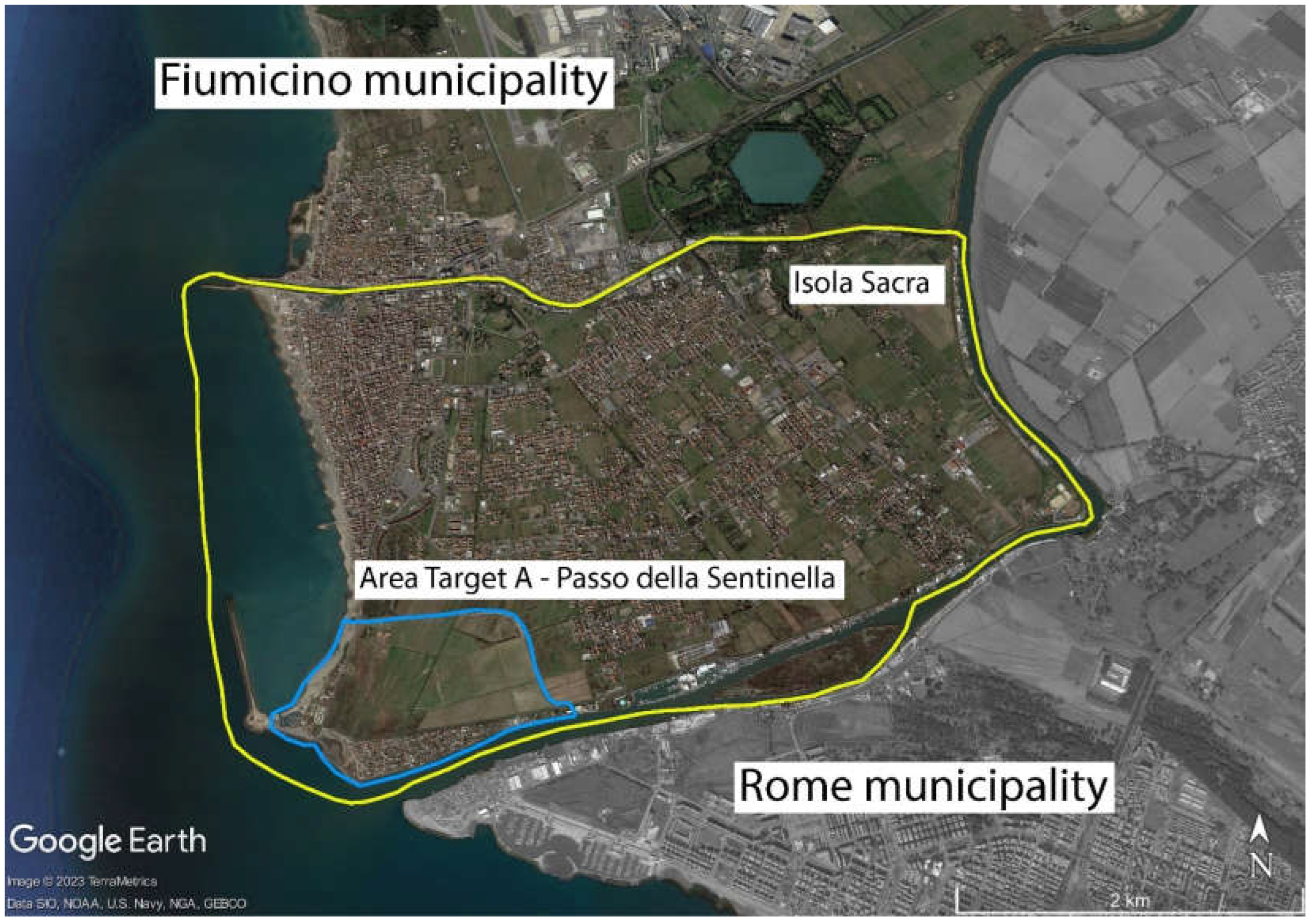
Figure 2.
View of the spontaneous settlement of Passo della Sentinella, located right at the mouth of the Tiber River. Detail of the “Trabocchi”. Source: The Tabloid. Available at: urly.it/3ns_x.
Figure 2.
View of the spontaneous settlement of Passo della Sentinella, located right at the mouth of the Tiber River. Detail of the “Trabocchi”. Source: The Tabloid. Available at: urly.it/3ns_x.
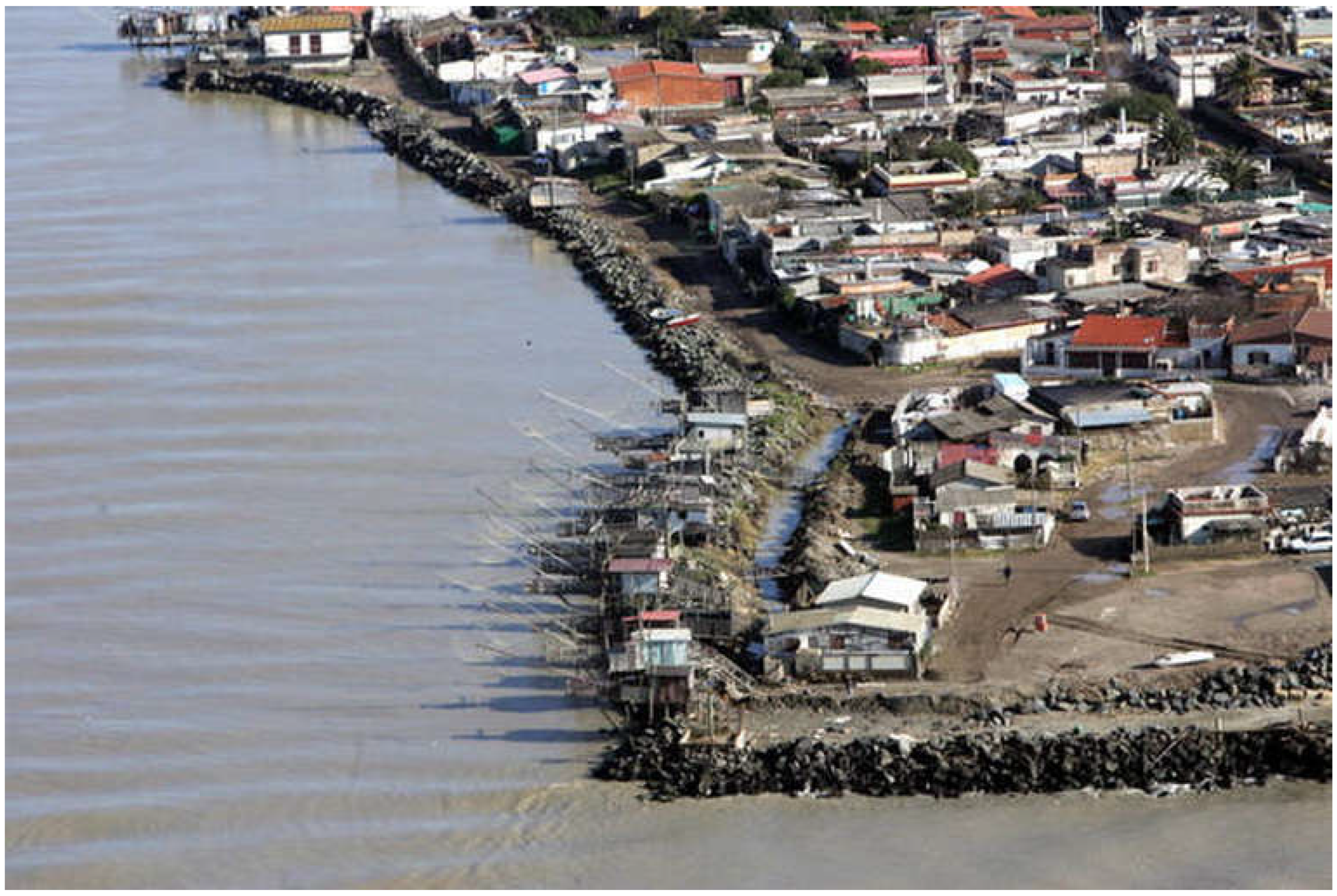
Figure 3.
View of the river from an internal area of Isola Sacra. Numerous imposing embankments that protect the settlement and the agricultural areas from floods, at the same time, deny the relationship, even visual, with the river. As a result, the only visible elements of the river landscape are the masts of boats, while the visual connection with the river itself is completely obstructed. Source: Marsia Marino (2021).
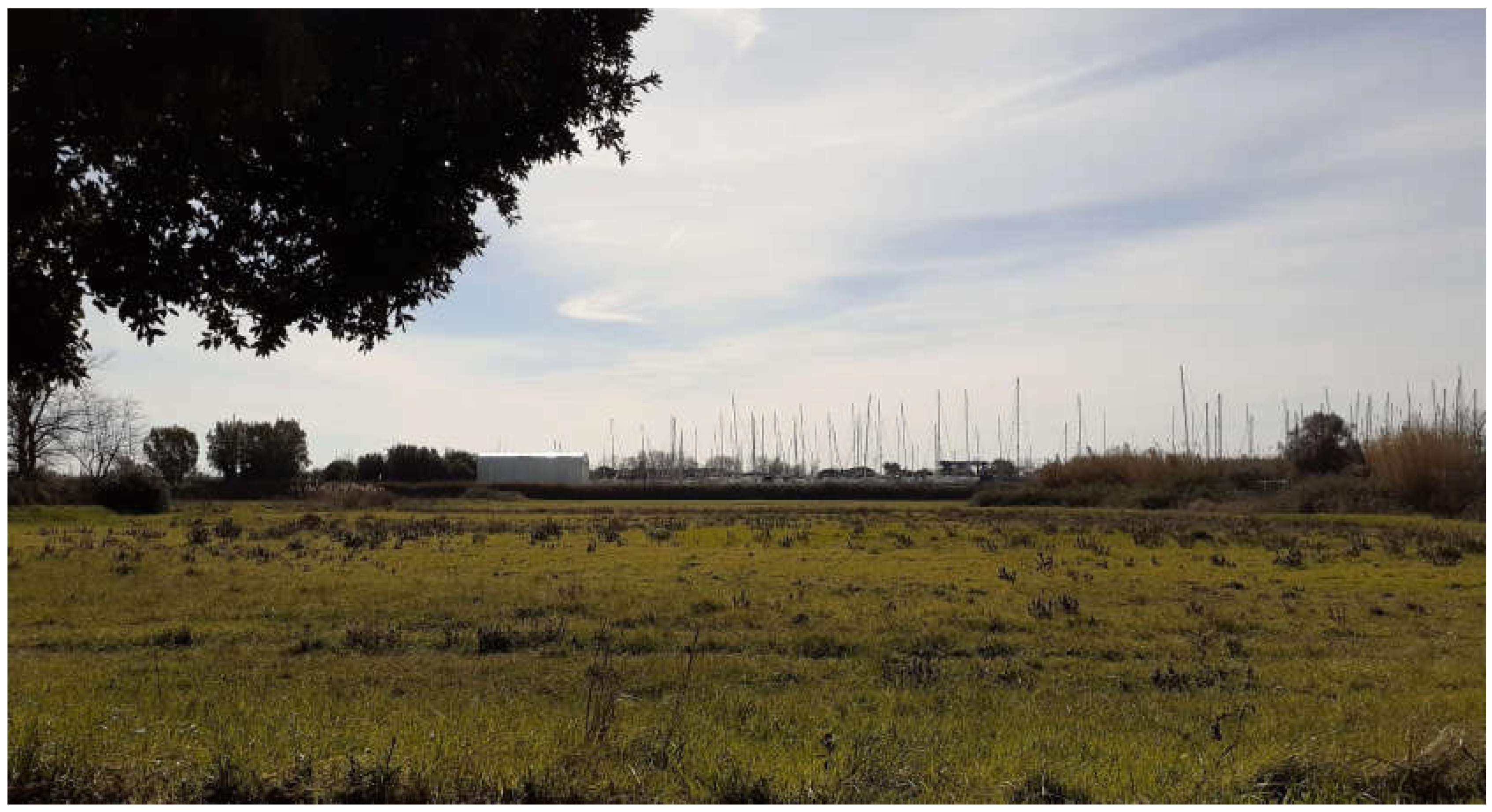
Figure 4.
An aerial view of the embankment road reveals that the spontaneous settlement of Passo della Sentinella is not protected by the embankment. Protection is only provided for the built-up area to the north of the embankment. Source: Google Heart Pro.
Figure 4.
An aerial view of the embankment road reveals that the spontaneous settlement of Passo della Sentinella is not protected by the embankment. Protection is only provided for the built-up area to the north of the embankment. Source: Google Heart Pro.
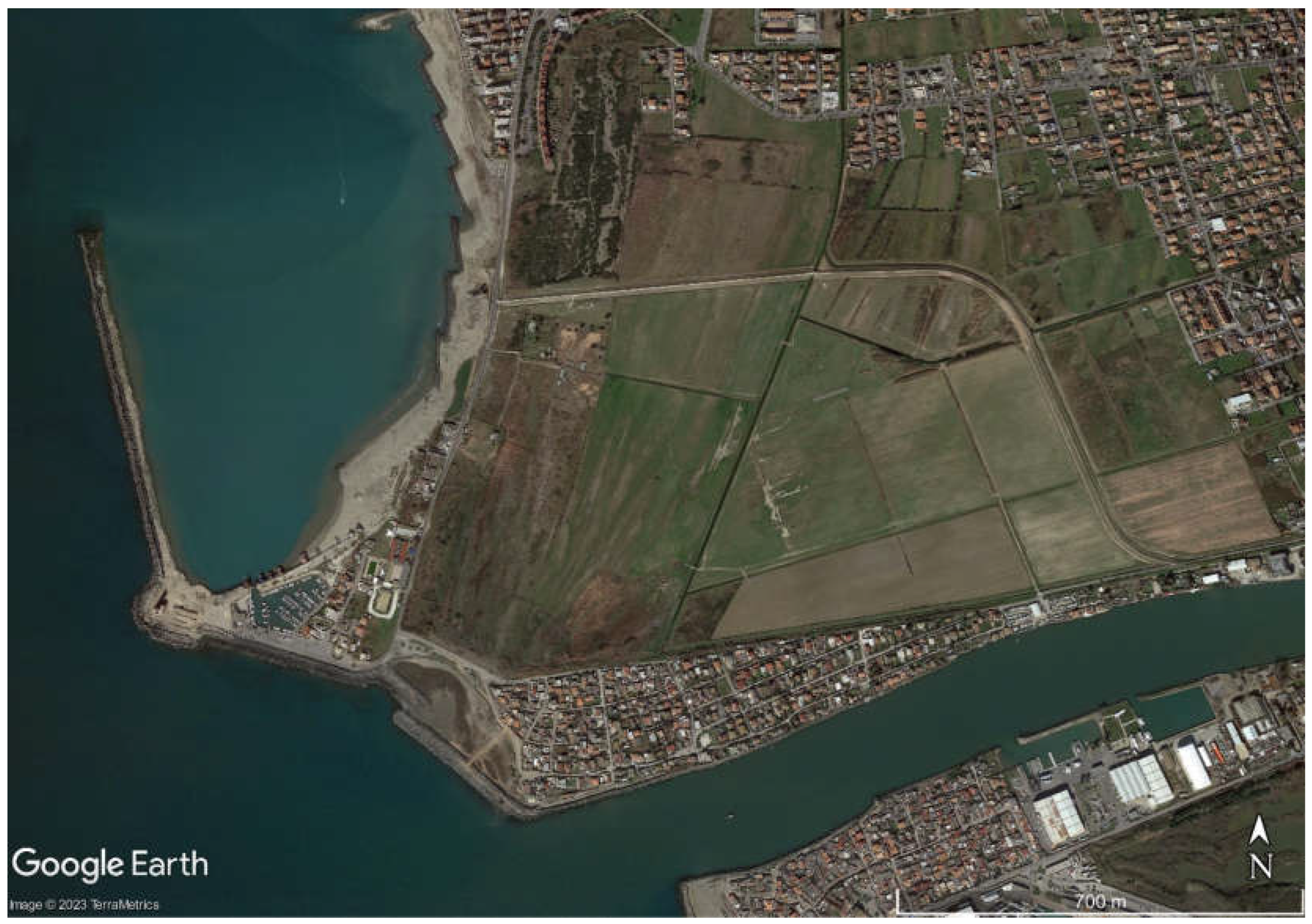
Figure 5.
(a) An extract from the 1962 PRG (General Regulatory Plan) of Rome, showing a detailed map of Isola Sacra. Here Passo della Sentinella is designated as a “public park”. (b) An extract from the 2006 PRG of Fiumicino, showing a detailed map of Isola Sacra. Here Passo della Sentinella is designated as “Sub-zone B1b”.
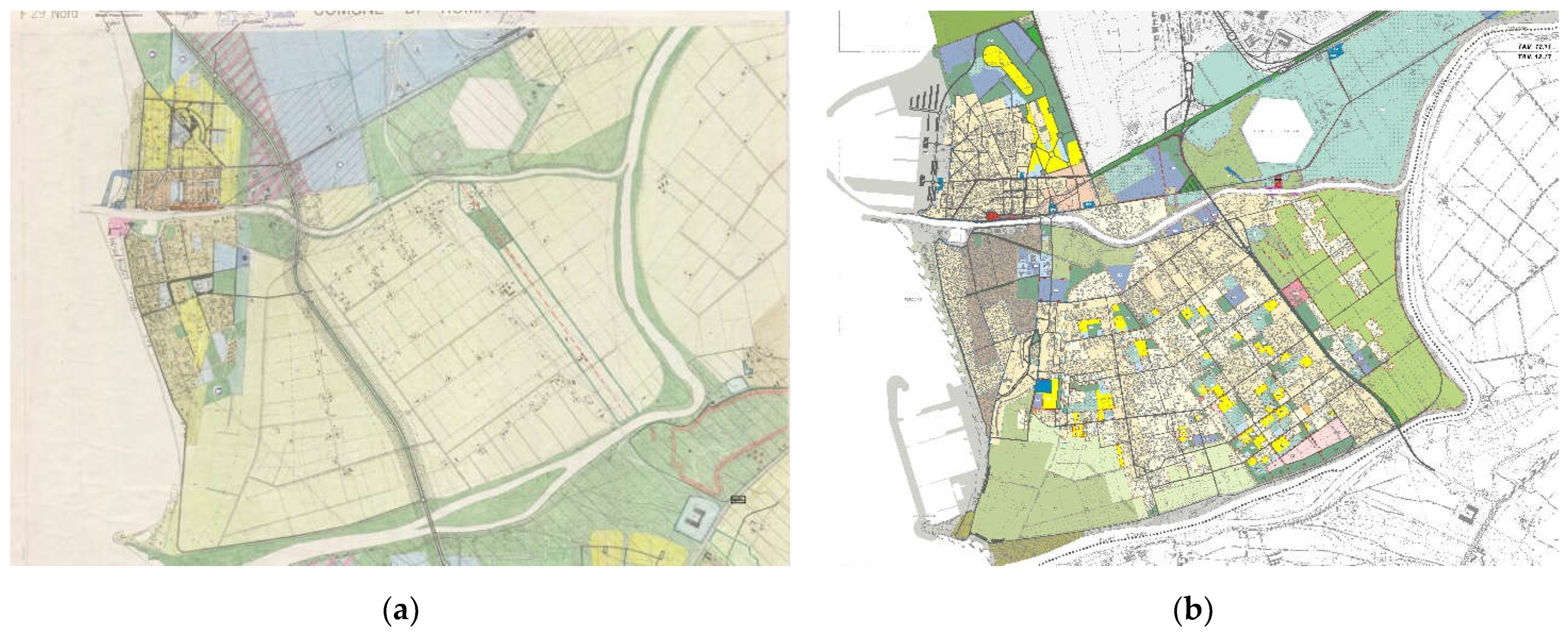
Figure 6.
Flood risk map developed by the Central Apennine District Basin Authority. Detail of Isola Sacra, Fiumicino (Lazio, Italy) area. Source: PGRAAC (2018).
Figure 6.
Flood risk map developed by the Central Apennine District Basin Authority. Detail of Isola Sacra, Fiumicino (Lazio, Italy) area. Source: PGRAAC (2018).
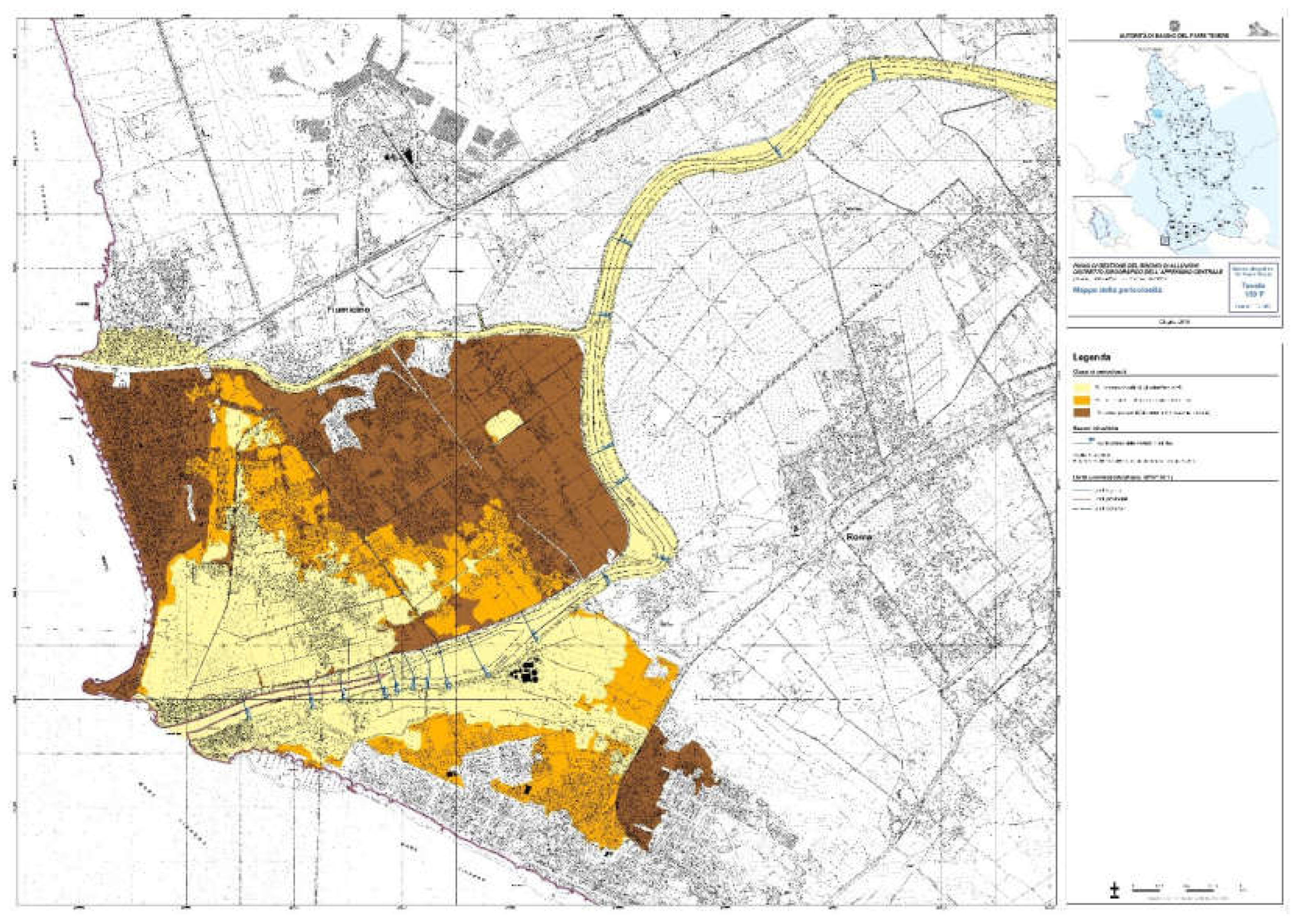
Figure 7.
Highlights of the Homogeneous sub-zones of the PRG of the Municipality of Fiumicino (2006). Software: Q-GIS 3.10.2. Authors’ elaboration (2023).
Figure 7.
Highlights of the Homogeneous sub-zones of the PRG of the Municipality of Fiumicino (2006). Software: Q-GIS 3.10.2. Authors’ elaboration (2023).
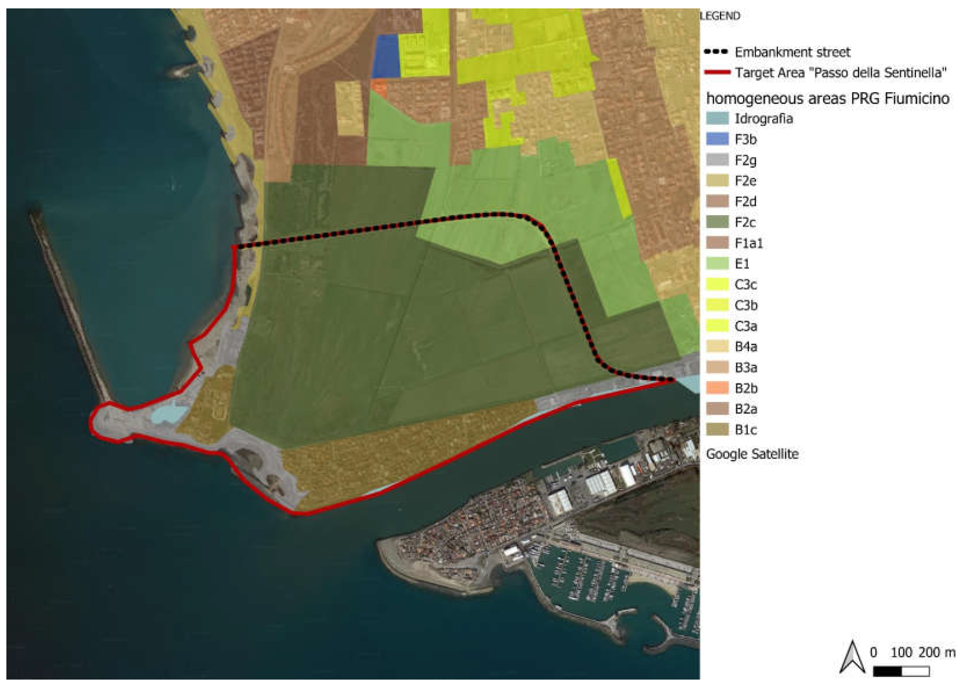
Figure 8.
Overlay of the projection of the coastline at 2100 to the PRG of Fiumicino (2006) to highlight the consistency of the areas at risk of flooding at 2100 due to SLR. Software: Q-GIS 3.10.2. Authors' elaboration (2023).
Figure 8.
Overlay of the projection of the coastline at 2100 to the PRG of Fiumicino (2006) to highlight the consistency of the areas at risk of flooding at 2100 due to SLR. Software: Q-GIS 3.10.2. Authors' elaboration (2023).
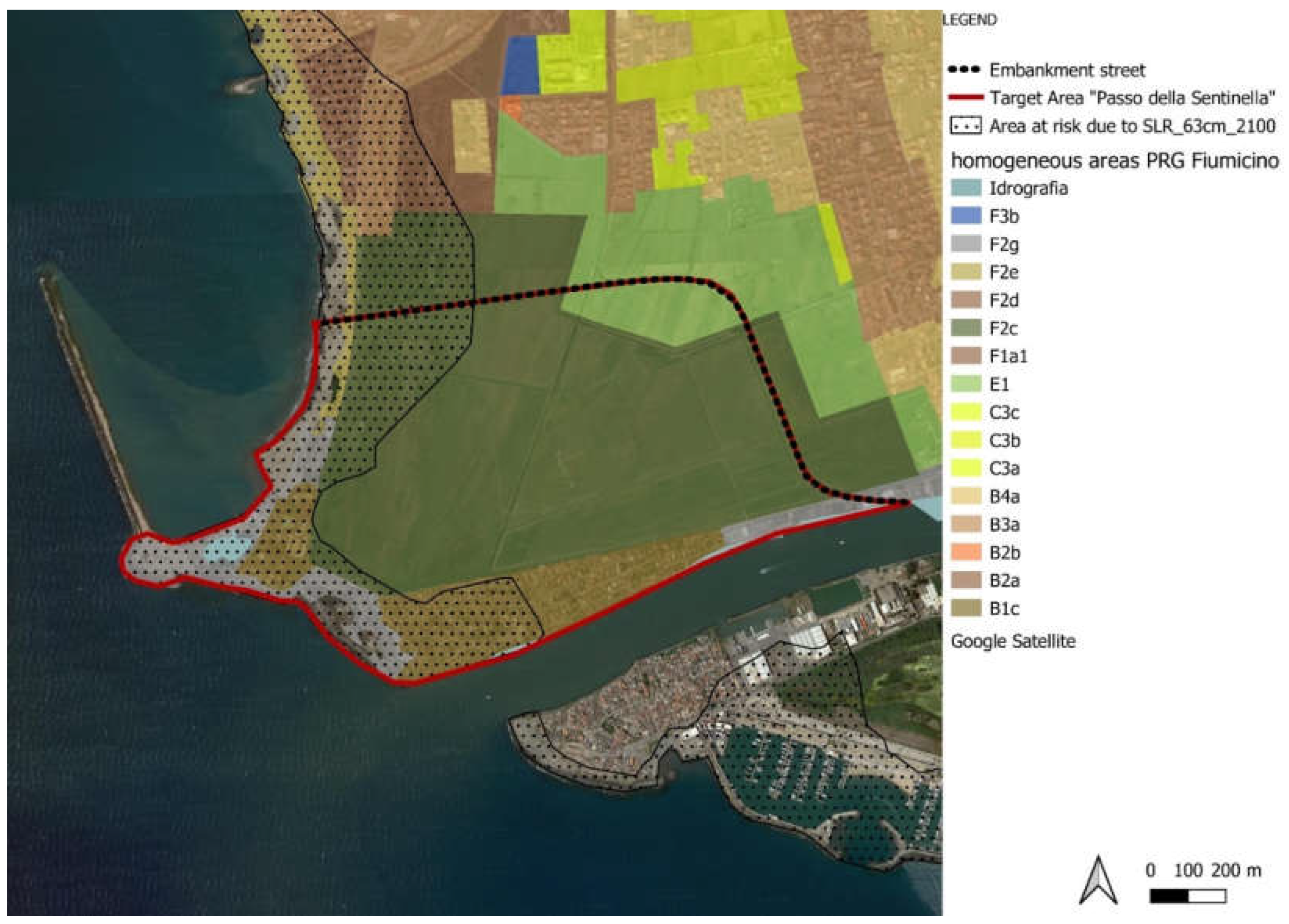
Figure 9.
Overlay of the shape files related to the flood risk with RP 30 and 100 years (due to heavy rainfall and river’s overflow) at the PRG of Fiumicino (2006). The area at risk RP 30 years and the one at risk RP 100 years are coincident for the Target Area A - Passo della Sentinella. Software: Q-GIS 3.10.2. Authors' elaboration (2023).
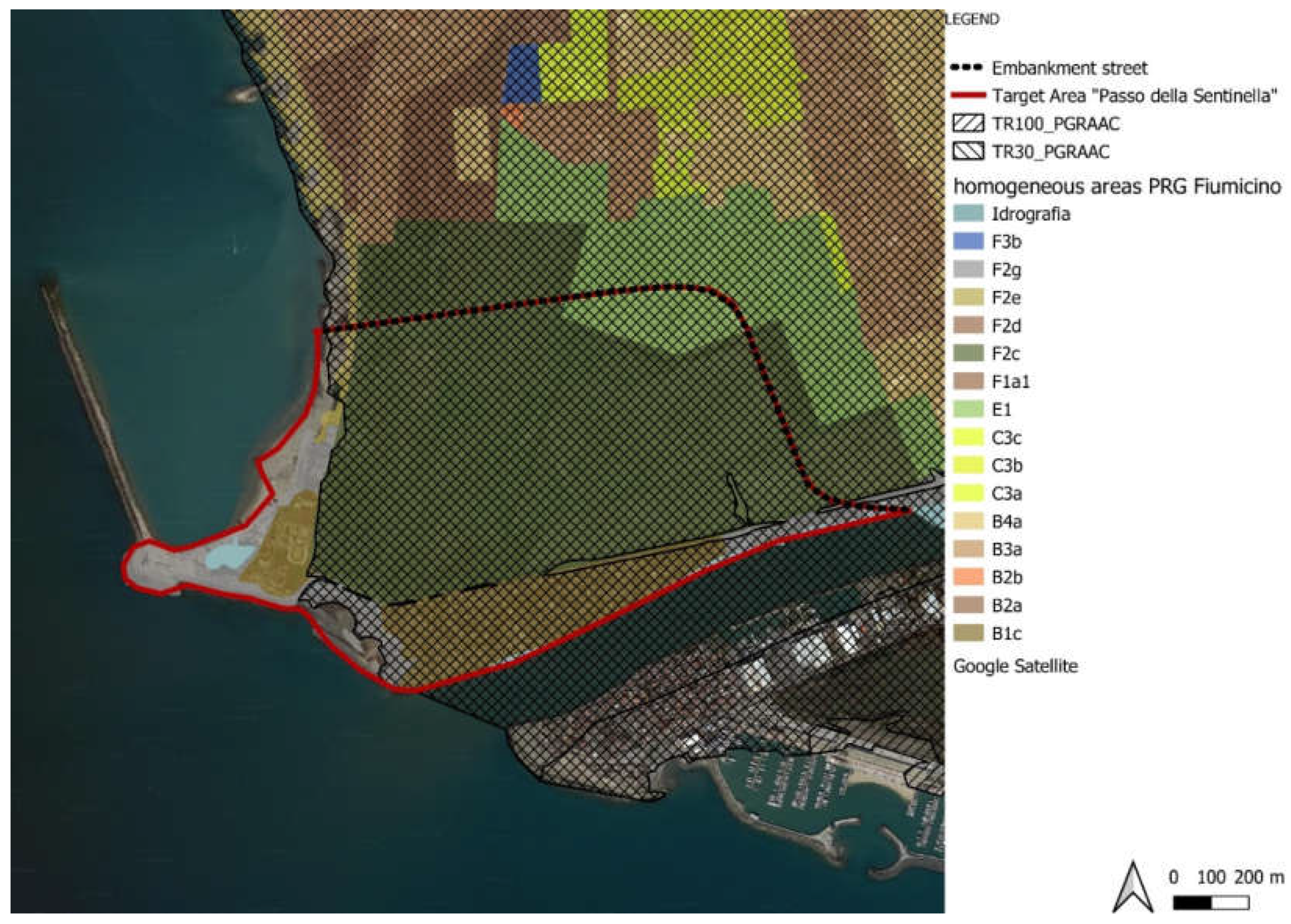
Figure 10.
Overlay of the areas at risk of flooding due to SLR by 2100 and the ones due to heavy rainfall and river’s overflow with RP 30 and 100 years at the PRG of Fiumicino (2006). The resulting map shows the areas subject to multiple risks, which encompass 100% of the extension of Target Area A - Passo della Sentinella. Software: Q-GIS 3.10.2. Authors' elaboration (2023).
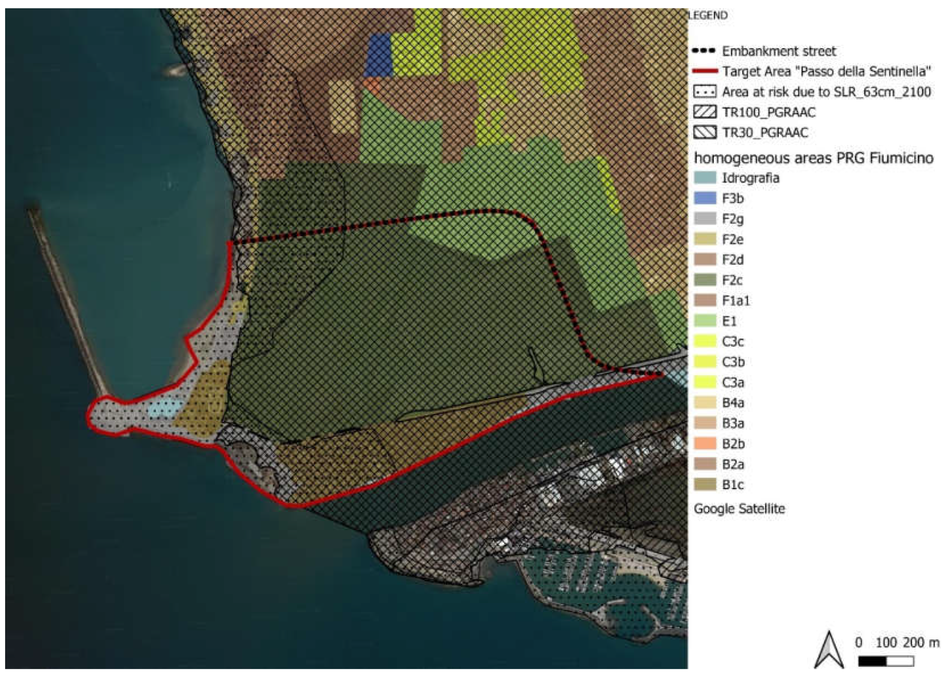

Table 1.
Technical Implementation Regulations (NTA) for the Homogeneous sub-zones of the Fiumicino PRG (2006) included in the Target Area A - Passo della Sentinella.
Table 1.
Technical Implementation Regulations (NTA) for the Homogeneous sub-zones of the Fiumicino PRG (2006) included in the Target Area A - Passo della Sentinella.
| Homogeneous Territorial Zones | Homogeneous sub-zone | Art. of the NTA | Specifications |
|---|---|---|---|
| B | Sub-zone B1c | Art. 54.3 Maintenance, completion and redevelopment of existing fabric: building maintenance zone for rehabilitation and environmental remediation |
[...] The nucleus known as Passo della Sentinella will be subjected to implementation planning aimed at the environmental redevelopment of the site. This target may be pursued through reclamation works, also after the demolition of the existing building stock and relocation of the same in external areas [...]. |
| E | Sub-zone E1 | Art. 60.1 Agricultural activities in suburban areas: agricultural areas in the settled territory | [...] Lands with hydrogeological vulnerability [...]. |
| F | Sub-zone F2c | Art. 63.4 Public green: Territorial Equipped Park | [...]Only public facilities that are essential for enjoying the park itself or for the recovery and redevelopment of the entire river channel are envisioned. |
| Sub-zone F2e | Art. 63.4 Public green areas may include concessionary facilities for coastal use, as well as open-air facilities for tourism and leisure activities | [...] The adaptation of sanitary facilities is permitted up to a 10% increase of the existing covered surface area, as well as the demolition and reconstruction of existing buildings, with indications of their use for bathing services, refreshments, storage, and outdoor equipment [...] | |
| Sub-zone F2g | Art. 63.8 Public green: Embankment Protection Area | [...] The reconversion of existing shipyards and buildings for use along the Tiber is allowed, if landscape and environmental principles and values are respected [...] |
Table 2.
Quanti-qualitative reading of areas affected by future flooding due to sea-level rise. Projection: 63 cm by 2100.
Table 2.
Quanti-qualitative reading of areas affected by future flooding due to sea-level rise. Projection: 63 cm by 2100.
| Homogeneous Territorial Zones | Homogeneous sub-zone | Area of the sub-zone within the target area | Area at risk falling within the sub-zone (%) |
|---|---|---|---|
| B | Sub-zone B1c | 186.294,84 m² | 111.421,442 m² (59,81%) |
| E | Sub-zone E1 | 57.865,863 m² | 0% |
| F | Sub-zone F2c | 781.719,024 m² | 115.745,177 m² (14,81%) |
| Sub-zone F2e | 9.239,793 m² | 100% | |
| Sub-zone F2g | 106.194,836 m² | 86.905,14 m² (81,84%) |
Table 3.
Quanti-qualitative reading of areas affected by flooding due to heavy rainfall and river’s overflow with 30-year RP and 100-year RP.
Table 3.
Quanti-qualitative reading of areas affected by flooding due to heavy rainfall and river’s overflow with 30-year RP and 100-year RP.
| Homogeneous Territorial Zones | Homogeneous sub-zone | Area of the sub-zone within the target area | Area at risk falling within the sub-zone (%) |
|---|---|---|---|
| B | Sub-zone B1c | 186.294,84 | 142.710,330 m² (76,69%) |
| E | Sub-zone E1 | 57.865,863 m² | 100% |
| F | Sub-zone F2c | 781.719,024 m² | 766.205,248 m² (98,02%) |
| Sub-zone F2e | 9.239,793 m² | 5.122,698 m² (55,44%) | |
| Sub-zone F2g | 106.194,836 m² | 38.362,938 m² (36,12%) |
Table 4.
Toolkit of site-specific actions applied to Target Area A – Passo della Sentinella.
 |
Disclaimer/Publisher’s Note: The statements, opinions and data contained in all publications are solely those of the individual author(s) and contributor(s) and not of MDPI and/or the editor(s). MDPI and/or the editor(s) disclaim responsibility for any injury to people or property resulting from any ideas, methods, instructions or products referred to in the content. |
© 2023 by the authors. Licensee MDPI, Basel, Switzerland. This article is an open access article distributed under the terms and conditions of the Creative Commons Attribution (CC BY) license (https://creativecommons.org/licenses/by/4.0/).
Copyright: This open access article is published under a Creative Commons CC BY 4.0 license, which permit the free download, distribution, and reuse, provided that the author and preprint are cited in any reuse.


