
Submitted:
07 January 2026
Posted:
08 January 2026
You are already at the latest version
Abstract
Rural defensive heritage sites are highly vulnerable assets that require decision-making under conditions of limited data and high uncertainty, particularly in the context of large-scale infrastructure projects and accelerating environmental processes. This study proposes a modular decision-support model for defining conservation priorities in a transparent, traceable, and data-sensitive manner, based on four selected fortress sites in the Yusufeli district of Artvin, Türkiye. The model employs a risk-based approach to quantify anthropogenic risks (AR) through the combined assessment of impact (I) and probability (P). Topographic and contextual vulnerability (TC) is structured through sub-indicators including visual dominance disruption, access discontinuities, landscape fragmentation, and microclimatic exposure, while material and intervention compatibility (MS) is evaluated as a distinct compatibility–risk component. These three modules are integrated through normalization and weighted aggregation into a single Priority Index (PI). In addition, the study introduces a Data Completeness Index (DCI) to explicitly address heterogeneity and gaps in field data, allowing prioritization outcomes to be interpreted with an associated confidence level. Laser-scanning-based documentation, deterioration mapping, and photographic records support the evidence-based construction of indicators. The proposed framework offers a transferable approach for generating intervention and monitoring priorities for rural defensive heritage under rapid landscape transformation, while explicitly managing data uncertainty rather than obscuring it.
Keywords:
rural defensive heritage
; prioritization
; multi-criteria decision-making
; risk matrix
; data completeness
; laser scanning
; deterioration analysis
; Yusufeli castles
1. Introduction
In the twenty-first century, the most pressing threats to cultural heritage sites arise not primarily from direct destruction, but from indirect and multi-layered transformation processes associated with large-scale development projects. Dams, energy infrastructure, transportation corridors, and rural resettlement policies generate irreversible spatial disruptions, particularly for defensive structures embedded within rural landscapes. While such interventions do not always result in the physical loss of historic fabric, they frequently detach heritage structures from their topographic context, visual control networks, and functional continuities, thereby increasing their vulnerability.
Within the international conservation literature, these processes are commonly discussed through frameworks addressing the relationship between development and heritage protection, with growing emphasis on the indirect and cumulative impacts of large-scale infrastructure projects. It is widely argued that conservation strategies must be integrated into sustainable development agendas and supported by impact-based assessment tools capable of anticipating long-term consequences for cultural heritage (UNESCO, 2011; ICOMOS, 2011). Recent studies further underline that assessments limited to structural integrity alone are insufficient, particularly in rural contexts where spatial parameters such as topography, accessibility, visual dominance, and contextual continuity play a decisive role in heritage significance.
Rural fortifications constructed during the medieval and early modern periods were not isolated architectural objects but components of broader defensive systems controlling valleys, passes, and settlement networks through carefully structured spatial and visual relationships. Their historical significance is therefore inseparable from the landscapes that enabled surveillance, access control, and territorial dominance. The transformation or loss of this contextual framework leads to the erosion of defensive logic and representational meaning, even when physical fabric remains largely intact.
Despite this recognition, conservation approaches addressing rural defensive heritage under development pressure often remain predominantly descriptive and lack transferable analytical tools for comparing risks or defining intervention priorities. In dam-affected landscapes, in particular, there is a clear need for decision-support frameworks capable of integrating anthropogenic risk, contextual vulnerability, and material sensitivity within a coherent and reproducible evaluation model. Responding to this gap, the present study proposes a multi-module assessment framework designed to support transparent prioritization and informed intervention strategies for rural fortification heritage exposed to post-dam landscape transformation.
1.1. Dam-Induced Landscape Transformation and the Contextual Vulnerability of Rural Defensive Structures
Large-scale dam projects should be understood not only as hydraulic or energy infrastructures, but as spatial interventions that fundamentally reshape settlement patterns, transportation networks, and cultural landscapes. In mountainous and valley-based geographies, such projects generate complex forms of vulnerability for rural defensive structures whose historical significance is inseparable from specific topographic and visual relationships. While many of these structures remain physically intact, they are frequently detached from the environmental and spatial systems that once sustained their defensive logic, resulting in sites that are preserved in situ but stripped of contextual meaning.
Within international conservation discourse, the impacts of dams and large-scale infrastructure on cultural heritage are increasingly addressed beyond questions of physical loss. It is widely emphasized that indirect processes such as landscape fragmentation, altered access networks, and the disruption of visual and spatial continuity must be considered as integral components of heritage risk (UNESCO, 2011). In response, impact-assessment-based approaches capable of systematically evaluating the effects of development projects on heritage values have been strongly advocated (ICOMOS, 2011). This shift has contributed to a broader understanding of heritage conservation as a landscape-scale and contextual challenge, rather than an issue confined to the material condition of individual structures.
In Türkiye, the most visible manifestation of this debate has been the case of Hasankeyf, where large portions of historic settlement fabric and monumental heritage were submerged following dam construction. However, the effects of dams are not limited to sites that are physically lost. Heritage structures located above reservoir levels may retain their material presence while undergoing profound transformations in valley relationships, access routes, and visual dominance networks. This condition demonstrates that even formally “preserved” sites can experience significant erosion of identity and meaning.
The Yusufeli region provides a particularly instructive context for examining such indirect impacts on rural defensive heritage. Constructed on the Çoruh River, the Yusufeli Dam triggered the relocation of the district center and numerous rural settlements, fundamentally reconfiguring historical transportation corridors, settlement–fortress relationships, and patterns of visual control within the valley. The fortresses of Bahçeli, Çevreli (Peterek), Kılıçkaya (Ersis), and Kınalıçam (Asparaşeni), although remaining physically intact above the reservoir level, have lost substantial components of the topographic and landscape relationships that once underpinned their defensive function.
The vulnerability of rural defensive structures differs significantly from that of urban monumental buildings. Fortresses were conceived not as isolated architectural objects, but as spatial systems operating through coordinated relationships with valleys, passes, paths, and lines of sight. Transformations affecting any element of this system directly undermine the structures’ capacity to convey historical function and meaning. In the Yusufeli context, the artificial reservoir landscape, newly introduced transportation axes, and altered microclimatic conditions collectively produce a multi-layered vulnerability environment that cannot be adequately addressed through restoration-focused approaches alone.
This condition necessitates a reconsideration of conservation strategies for rural defensive heritage. For fortresses that retain substantial physical integrity but have experienced severe contextual disruption, traditional repair-oriented interventions are insufficient. Instead, there is a need for analytical frameworks capable of jointly addressing anthropogenic risk, contextual vulnerability, and material sensitivity, thereby enabling risks to be compared and intervention priorities to be explicitly defined (ICOMOS, 2011).
The Yusufeli district and its surrounding fortresses constitute the empirical field in which such a framework is developed and tested. The spatial relationships between the four case-study fortresses, the dam reservoir, and primary transportation axes are presented in Figure 1, which provides the spatial basis for the risk and vulnerability indicators—such as access, contextual disruption, and exposure to anthropogenic threats—examined in the following sections.
1.1. Research Question, Methodological Positioning, and Rationale for the Proposed Model
This study aims to develop an analytical and comparable assessment framework for the conservation of rural defensive heritage affected by dam projects and similar large-scale development interventions. Existing approaches in the literature predominantly address rural fortresses through historical–typological analyses or building-scale restoration debates, offering limited methodological guidance for evaluating vulnerabilities arising from disrupted relationships with topography, landscape, and access systems.
Against this background, the study is structured around the following research question:
Can a transferable conservation assessment model be developed for rural defensive structures affected by dam-induced landscape transformation, integrating topographic adaptation, anthropogenic threats, and material sensitivity within a unified analytical framework?
To address this question, the study advances three interrelated methodological contributions. First, it reconceptualizes vulnerability in rural defensive heritage beyond physical deterioration alone by incorporating spatial and contextual parameters such as the loss of topographic continuity, the weakening of visual dominance, and the transformation of access networks. This approach recognizes fortresses as spatial systems rather than isolated architectural objects.
Second, the study proposes a multi-criteria risk assessment framework that renders anthropogenic pressures comparable at the building scale. Factors such as post-dam microclimatic change, newly introduced transportation infrastructures, and shifts in settlement patterns are systematically evaluated through impact- and probability-based indicators, enabling the comparative assessment of risk profiles across multiple sites.
Third, material analysis is explicitly integrated into the decision-making process. Rather than treating material characterization as a descriptive appendix, laboratory-based findings are linked directly to intervention logic, allowing material sensitivity and compatibility to inform prioritization and conservation strategy selection.
Within this framework, the Yusufeli fortresses function not merely as illustrative case studies but as an analytical laboratory for model development and testing. The fortresses of Bahçeli, Çevreli (Peterek), Kılıçkaya (Ersis), and Kınalıçam (Asparaşeni) exhibit varying topographic settings, degrees of dam-related transformation, and anthropogenic threat profiles, enabling the comparative evaluation of the model’s analytical performance. This structure allows the study to move beyond site-specific recommendations toward the formulation of a transferable decision-support tool applicable to rural defensive heritage under similar contextual pressures.
Methodologically, the proposed model is grounded in a multi-criteria evaluation logic that integrates qualitative observations with quantitative and semi-quantitative data. Anthropogenic risks are quantified through impact and probability parameters, while topographic vulnerability, material sensitivity, and contextual disruption indicators are weighted to generate structure-specific vulnerability and prioritization indices. This approach supports conservation decisions based on transparent, traceable, and reproducible criteria rather than intuitive or purely descriptive judgments.
In this respect, the study aligns with the principles of contextual integrity, risk-based conservation, and preventive approaches emphasized by UNESCO and ICOMOS. Rather than reiterating these principles at a conceptual level, the proposed model translates them into operational indicators, tables, and graphical outputs, offering a practical and methodologically grounded framework for the conservation of rural defensive heritage under conditions of landscape-scale transformation.
1.1. Rural Defensive Heritage, Development-Induced Risks, and the Methodological Gap in the Literature
The literature on the conservation of rural defensive structures has traditionally focused on historical origins, typological classifications, and military functions. Studies on medieval fortresses and frontier defense systems, particularly in European and Caucasian contexts, have emphasized political geography and power relations, while their interaction with topography has often remained descriptive rather than analytical (Lang, 1966; Toumanoff, 1967; Rapp, 2014). Although this body of work establishes the historical significance of defensive architecture, it offers limited methodological guidance for assessing vulnerabilities generated under contemporary development pressures.
More recently, development-induced risk perspectives have gained prominence in cultural heritage studies, addressing both the direct and indirect impacts of large-scale infrastructure projects on heritage assets. Dams, energy facilities, and transportation infrastructures are shown to transform not only physical integrity but also cultural landscapes, spatial continuity, and representational values (González-Varas, 2018; Labadi, 2017). These discussions have contributed to the institutionalization of risk-based and preventive conservation approaches, with concepts such as context, landscape, and indirect impact occupying a central position in UNESCO and ICOMOS policy frameworks (UNESCO, 2011; ICOMOS, 2011).
The cultural landscape literature further expands this debate by conceptualizing landscape as a dynamic product of long-term human–environment interaction, requiring heritage sites to be evaluated within broader spatial and relational networks (Ashworth, Graham & Tunbridge, 2007; Fairclough et al., 2018). However, in studies of defensive heritage, landscape is frequently treated as a visual backdrop rather than as an analytical component. Key elements that structure defensive logic—such as topographic adaptation, visual dominance, and access systems—are rarely translated into measurable assessment parameters.
At the same time, existing risk-based conservation and vulnerability assessment models have been developed primarily for urban heritage, monumental architecture, or individual historic buildings. These models successfully quantify structural damage, material deterioration, and environmental factors, yet they inadequately capture the specific conditions of rural defensive structures, whose significance depends on integrated relationships between architecture, topography, access, and visual control (Jokilehto, 1999; Feilden, 2003; Letellier et al., 2007). As a result, the literature lacks a multi-criteria and transferable assessment framework capable of jointly addressing contextual disruption, anthropogenic risk, and intervention prioritization for rural defensive heritage.
This methodological gap becomes particularly evident in regions undergoing radical landscape transformation due to dam projects. Fortresses that remain physically intact but lose their environmental, visual, and functional contexts are often treated as cases of “secondary loss,” without clear criteria for defining, measuring, or prioritizing such losses within conservation decision-making processes (González-Varas, 2018; Harrison, 2015). Consequently, conservation strategies frequently rely on descriptive evaluations rather than comparable and decision-oriented analytical tools.
Against this background, the present study addresses this gap through the case of the Yusufeli fortresses by integrating topographic adaptation, anthropogenic threats, and material sensitivity within a unified assessment system. Rather than reiterating theoretical debates, the study operationalizes them through explicit indicators, analytical tables, and comparative evaluations, proposing a transferable and decision-support-oriented model for the conservation of rural defensive heritage under development-induced landscape transformation.
2. Materials and Methods
To address the methodological gap identified in the conservation of rural defensive heritage under development pressure, this study adopts a multi-layered analytical approach that integrates physical, spatial, and contextual data into a unified assessment framework. The method is designed as a decision-oriented and reproducible evaluation protocol, enabling comparative prioritization of rural fortresses affected by large-scale landscape transformation.
The analytical framework assesses both the physical condition and the representational potential of historic fortresses impacted by the Yusufeli Dam between 2013 and 2023. The core dataset consists of laser-scanning-derived point cloud data and deterioration–intervention mappings produced for each site. These datasets are systematically combined with plan–topography relationships, visual dominance analyses, and the classification of anthropogenic threats, allowing field observations to be translated into structured and comparable analytical indicators. This documentation-driven approach, grounded in observation and contextual reading, aligns with recent conservation studies that treat measured evidence and surrounding relationships as the basis for developing conservation proposals (Tupal Yeke, 2023).
The methodology is grounded in a conservation–documentation approach that treats metric documentation not as illustrative output but as a primary analytical input informing conservation decision-making (Letellier et al., 2007). This analytical position aligns with recent spatial analysis studies that employ numerical and visual metrics to interpret spatial organization as a measurable input rather than a descriptive outcome (Şuta & Zencirkıran, 2024). In contexts characterized by high seismic exposure, post-earthquake reconnaissance studies have demonstrated the importance of systematic and measurable assessment frameworks for evaluating structural vulnerability, reinforcing the relevance of risk-informed analytical approaches in heritage evaluation (Çağlar et al., 2024). Laser scanning and mapping data are used to evaluate topographic adaptation, contextual disruption, and exposure to anthropogenic risks. Such risk exposure should be understood not only as a material condition but as a cumulative process shaped by environmental forces, contextual pressures, and long-term interaction between structure and landscape, reinforcing the need for integrated and sustainability-oriented assessment frameworks (Beyhan & Ünügür, 2010; Tapkı, 2018). This aligns with integrated conservation and sustainability-oriented governance approaches emphasized in Turkey’s conservation framework and its international reference field (Kamacı, 2014). In this way, the assessment moves beyond building-scale condition surveys and incorporates landscape-level transformations, access reconfiguration, and altered visual relationships as measurable components of vulnerability.
Through this integrated structure, the study proposes a transferable assessment protocol capable of evaluating both direct and indirect impacts of large-scale infrastructure projects on rural defensive heritage. The framework supports the production of structure-specific vulnerability and prioritization outcomes, rather than site-specific descriptive narratives.
2.1. Data Sources and Scope
The study examines four rural fortresses located in the Yusufeli region: Bahçeli, Çevreli (Peterek), Kılıçkaya (Ersis), and Kınalıçam (Asparaşeni). For each site, a core documentation dataset is available, comprising laser-scanning-derived point cloud data, deterioration and intervention mapping, and photographic documentation. These materials enable the analysis of topographic positioning, access conditions, and visual dominance relationships at both site and landscape scales.
Material characterization data, including petrographic and XRD analyses, are available for the Bahçeli, Çevreli, and Kınalıçam fortresses. For Kılıçkaya Fortress, laboratory-based material data are limited. Rather than compensating for this gap, the assessment framework explicitly incorporates variations in data availability through differentiated confidence levels, ensuring that uncertainty is made visible and traceable within the decision-support process.
2.2. Five-Stage Assessment Protocol
The proposed model is structured as a five-stage sequential assessment protocol (Figure 2). This methodological workflow follows a logic consistent with impact-assessment approaches developed for anticipating and managing the effects of large-scale interventions on cultural heritage (ICOMOS, 2011; ICCROM).
The assessment protocol comprises the following stages:
- Definition of the historical and geopolitical framework
- Field documentation and topographic modelling
- Material characterization
- Analysis of anthropogenic threats
- Development of the conservation and intervention framework
This five-stage structure is designed to integrate heterogeneous data types into a coherent analytical process and to establish a comparable evaluation basis for each fortress.

Table 1.
Alignment of the proposed assessment protocol with Heritage Impact Assessment (HIA) phases.
Table 1.
Alignment of the proposed assessment protocol with Heritage Impact Assessment (HIA) phases.
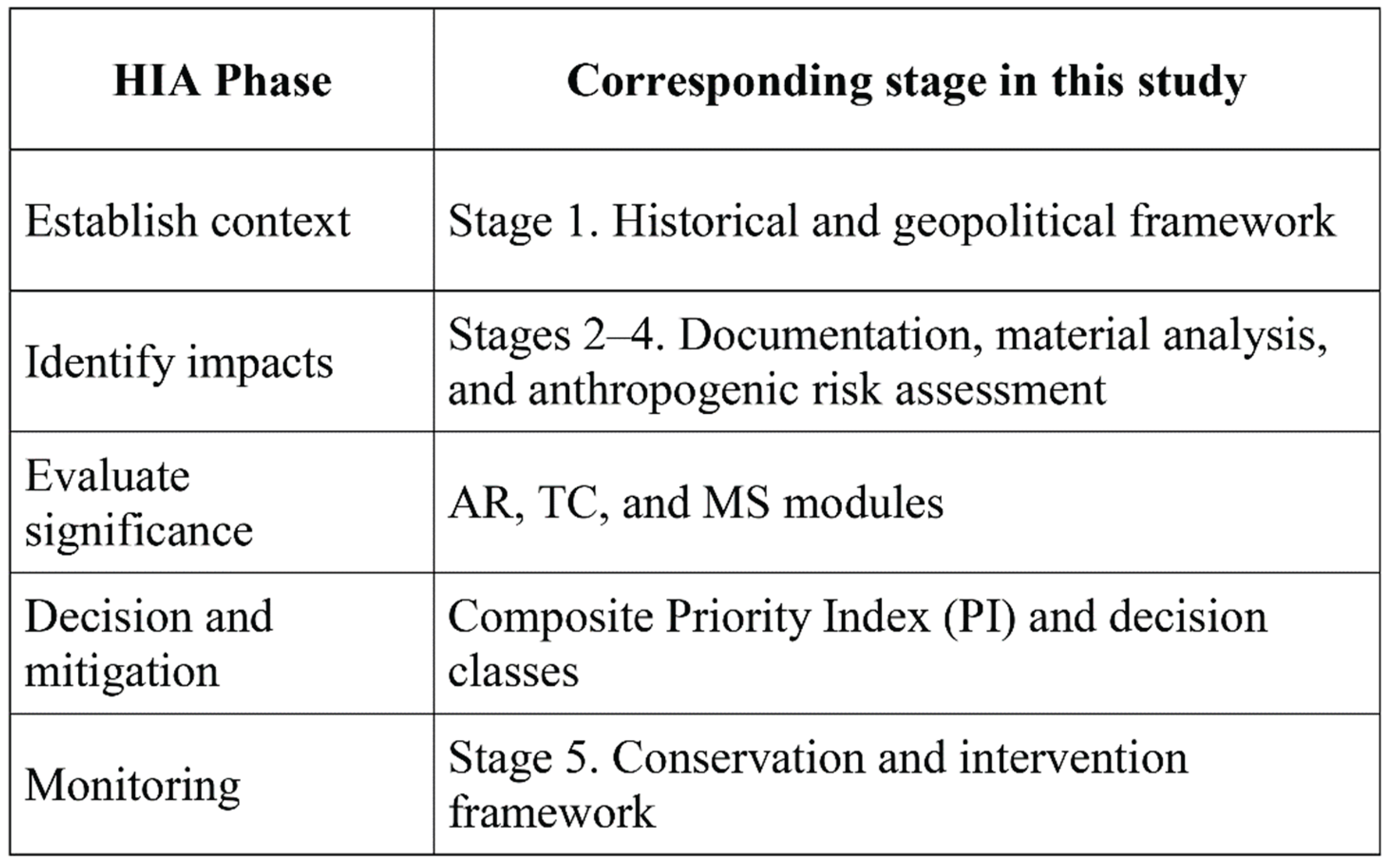
The five-stage assessment protocol adopted in this study follows the sequential logic of Heritage Impact Assessment frameworks by systematically linking contextual analysis, impact identification, significance evaluation, and decision-making. Rather than treating HIA as a parallel or external procedure, its core phases are embedded within the modular structure of the model. This alignment ensures that prioritization outcomes are directly connected to impact-based reasoning and can be translated into mitigation, intervention, and monitoring decisions.
2.3. Scoring Logic and Calculation Framework
This study translates standard risk management principles, including risk identification, analysis, and evaluation as defined in ISO 31000, into a numerical scoring system adapted to the contextual vulnerabilities of rural defensive heritage (ISO, 2018). The integration of different risk and vulnerability components within a single evaluation framework is based on a weighted summation approach commonly used in the multi-criteria decision analysis (MCDA) literature (Belton and Stewart, 2002).
Accordingly, anthropogenic risks, topographic–contextual vulnerabilities, and material sensitivity are calculated as separate modules for each fortress and then combined into a composite vulnerability index. The calculation logic is summarized below.
A. Anthropogenic Risk Score (AR)
For each anthropogenic threat, the site-based risk value is defined as the product of impact and probability:
where
R(t,c) = I(t,c) x P(t,c)
I represents the level of impact, and P represents the probability of occurrence (1–3: low, medium, high).
The overall anthropogenic risk score for each fortress is calculated as the arithmetic mean of all identified threat-based risk values:
AR(c) = (1 / n) x sum of R(t,c) for t = 1 to n
B. Topographic and Contextual Vulnerability (TC)
Topographic and contextual vulnerability is defined as the weighted sum of four normalized sub-indicators:
TC(c) = w1 x V(c) + w2 x A(c) + w3 x L(c) + w4 x M(c)
These sub-indicators represent visual dominance disruption (V), access fragmentation (A), landscape fragmentation (L), and microclimatic exposure (M). Each indicator is normalized within the 0–1 range.
C. Material Sensitivity and Intervention Compatibility (MS)
For fortresses where petrographic and XRD data are available, material sensitivity is evaluated through the compatibility between original stone and mortar characteristics and existing or proposed interventions. In cases where material data are unavailable, this module is excluded from the calculation and explicitly addressed within the data completeness index.
D. Composite Vulnerability Index (CVI)
The three main modules are integrated into a composite vulnerability index using a weighted summation approach:
where alpha + beta + gamma = 1.
CVI(c) = alpha x AR(c) + beta x TC(c) + gamma x MS(c)
Weight coefficients are defined according to the contextual priorities of the study.
E. Data Completeness and Confidence Index (DCI)
To support the interpretability of the model outputs, a data completeness ratio is calculated for each fortress:
where k represents the number of available indicators and K denotes the total number of theoretically defined indicators.
DCI(c) = k(c) / K
An overview of the applied modules, indicators, scales, and data sources is provided in Table 2.
2.4. Five-Stage Assessment Protocol
The proposed model operates through five sequential stages designed to translate documentation data into conservation decisions within a reproducible analytical workflow (Figure 5). The framework follows a logic consistent with approaches developed for identifying, analysing, and managing the impacts of large-scale interventions such as dams, transportation infrastructures, and landscape transformations on cultural heritage. In particular, the methodological structure aligns with the Heritage Impact Assessment (HIA) sequence of establishing context, analysing impacts, and generating decisions and monitoring strategies.
- Stage 1. Historical and Geopolitical Framework
The investigated rural defensive structures are evaluated not merely as physical remains, but within their broader contexts of frontier geography, administrative change, military and logistical networks, and local settlement relations. Archival research and historical topographic interpretation are used to identify the strategic rationale behind site selection and patterns of continuity or transformation in use. This stage ensures that risk and vulnerability indicators generated in subsequent phases are grounded in contextual meaning rather than functioning as abstract numerical scores.
- Stage 2. Field Documentation and Topographic Modelling
Measured drawings, photogrammetric survey outputs, and laser scanning (point cloud) data are jointly evaluated to establish fortress–topography relationships through a multi-scale documentation framework. The documentation process follows metric survey specifications for cultural heritage structures, including measurement accuracy, ground control point usage, data integrity, and output comparability (Historic England, 2018). The primary objective is to translate spatial characteristics such as approach routes, lines of sight, terrain integration, and rupture points into measurable and comparable representations. Consequently, indicators such as access fragmentation, loss of visual dominance, and landscape fragmentation are analysed through documentation-based spatial readings rather than qualitative observation alone.
- Stage 3. Material Characterization
Petrographic and XRD analyses conducted on mortar and stone samples are used to determine original material composition, aggregate properties, and binder–aggregate relationships. Rather than treating laboratory results as purely descriptive outputs, this stage aims to translate analytical findings into principles guiding compatible intervention strategies. As emphasized in technical guidelines for mortar analysis, the combined interpretation of mineralogical, petrographic, chemical, and proportional characteristics is essential for producing reliable and applicable conservation decisions.
- Stage 4. Analysis of Anthropogenic Threats
Anthropogenic threats are classified to include dam and reservoir effects, new road construction and vibration, microclimatic changes and salt crystallization processes, geotechnical risks such as landslides and rockfall, and vandalism or illicit excavations. The objective of this stage is not only to identify threats, but to situate them within a comparable risk framework for each fortress, thereby generating analytical inputs for conservation prioritization. The use of shared terminology and standardized classifications, particularly for deterioration types such as salt crystallization, surface loss, and crack development, supports the traceability and comparability of risk assessments.
- Stage 5. Conservation and Intervention Framework
Topographic, material, and threat-related data generated in the preceding stages are integrated to define (i) intervention approaches compatible with local and original materials, (ii) implementation decisions sensitive to topographic access and logistical constraints, and (iii) monitoring and preventive maintenance strategies. This stage represents the point at which documentation and analytical outputs are directly translated into decision-support tools, enabling the prioritization of fortresses and the formulation of long-term monitoring strategies. Subsequently, a modular assessment matrix is presented in tabular form, matching indicators, scoring scales, and data sources. This table constitutes the structural backbone of the Methods section and ensures the transparency of the proposed model.
2.5. Score Integration, Uncertainty Management, and Prioritization Outputs
This section defines how module scores (AR, TC, MS, DCI) are rendered comparable across the investigated fortresses, integrated into a single prioritization framework, and interpreted in a manner that explicitly reflects uncertainty resulting from data gaps. The approach follows the core logic of risk management, encompassing identification, analysis, evaluation, and decision-making stages (ISO, 2018). The aggregation of module scores into a composite index is based on a weighted summation approach commonly applied in multi-criteria decision analysis (Belton and Stewart, 2002).
2.5.1. Normalization and Comparability
Because the modules are defined on different numerical scales, scale harmonization constitutes the first step. Topographic and contextual vulnerability (TC), material sensitivity (MS), and the data completeness and confidence index (DCI) are defined within a 0–1 range. The anthropogenic risk score (AR), derived from the product of impact and probability, takes values between 1 and 3 and is therefore normalized to enable comparability:
AR_norm = (AR − 1) / 2
The material sensitivity and intervention compatibility module (MS) is formulated according to a compatibility-based logic, in which higher values indicate lower risk. As the prioritization framework is risk-oriented, MS is transformed into a risk variable:
MS_risk = 1 − MS
Through this transformation, high material compatibility does not generate prioritization urgency, whereas increasing incompatibility is directly reflected as elevated risk. This approach aligns with international conservation principles emphasizing compatibility, minimum intervention, and reversibility (Australia ICOMOS, 2013).
2.5.2. Composite Priority Index (PI)
Following normalization, a Composite Priority Index (PI) is calculated for each fortress as the weighted sum of the three main modules:
where w_AR, w_TC, and w_MS denote the weighting coefficients assigned to anthropogenic risk, contextual vulnerability, and material–intervention compatibility, respectively, with their sum equal to 1. In this study, an equal-weight configuration (w_AR = w_TC = w_MS) was deliberately adopted to ensure transparency, traceability, and reproducibility of the prioritization logic across contexts characterized by heterogeneous data availability. Expert-judgement-based weighting methods such as the Analytic Hierarchy Process (AHP) were not applied, as the absence of a structured expert panel would have introduced implicit subjectivity without increasing analytical robustness.
PI = w_AR × AR_norm + w_TC × TC + w_MS × MS_risk
To examine the stability of the prioritization results, a basic sensitivity check was performed by modifying individual module weights while holding the remaining coefficients constant. Alternative scenarios included increasing w_AR to 0.5 and, separately, increasing w_TC to 0.5. In both cases, the relative priority ranking of the castles remained stable, indicating that the model outputs are not driven by a single weighting assumption but reflect consistent underlying risk and vulnerability patterns.
2.5.3. Data Completeness (DCI) as an Uncertainty Filter
A key strength of the proposed model is its explicit treatment of data gaps rather than their concealment. The Data Completeness and Confidence Index (DCI) is introduced as a separate evaluative layer that indicates the evidential reliability of the results produced for each fortress. This approach aligns with international conservation principles emphasizing transparency, documentation adequacy, and levels of evidence in decision-making processes (Australia ICOMOS, 2013).
The DCI may be applied in two alternative ways:
A. Joint reporting of PI and DCI.
In this approach, conservation decisions are interpreted through a two-dimensional reading that considers both intervention priority and confidence level.
B. Adjustment of PI by DCI to generate an “actionable priority” score:
PI_adj = PI x DCI
Although the second option may be advantageous in applied planning contexts, the first approach generally offers a more robust academic interpretation. When PI values are high but DCI values are low, comprehensive interventions are not immediately recommended. Instead, priority is given to targeted data completion combined with parallel, risk-reducing temporary measures. This logic follows the principle of “evidence first, irreversible decisions later,” widely emphasized in heritage impact assessment and risk management literature (ICOMOS, 2011).
2.5.4. Decision Matrix: Interpreting PI and DCI Together
Rather than presenting results solely as a numerical ranking, the model frames them within a decision-oriented interpretive matrix. The proposed decision logic is as follows:
- High PI and high DCI: urgent intervention package (stabilization, risk mitigation, monitoring)
- High PI and low DCI: priority data completion combined with rapid risk-reduction measures
- Moderate PI and high DCI: planned preventive maintenance and periodic monitoring
- Low PI and low DCI: completion of inventory and evidence base
By explicitly integrating uncertainty and evidence quality into the evaluation process, this matrix avoids reducing conservation priorities to a single numerical outcome. Such an approach provides a more defensible and transparent planning framework, particularly in landscapes undergoing rapid transformation due to large-scale infrastructure projects (ICOMOS, 2011).
2.5.5. Output Set and Reporting Structure
The output set generated at the conclusion of this section is standardized as follows:
- Fortress-based priority ranking (PI or PI_adj)
- Module-based identification of critical weaknesses (AR, TC, MS)
- Intervention packages (urgent, medium-term, long-term)
- Monitoring and preventive maintenance plans (risk-type-based periodicity)
- Visual decision-support tools, including module tables, heatmaps, graphs, and mapping outputs
This study does not seek to develop a statistical prediction model. Instead, it proposes a multi-criteria, semi-quantitative decision-support framework designed to inform conservation planning under conditions of uncertainty.
2.6. Data Availability and Reproducibility
The proposed multi-module prioritization model is structured to enable replication and application in comparable rural defensive heritage contexts. Reproducibility of the assessment requires a clearly defined indicator set, explicit scoring ranges, transparent weighting schemes, and traceable calculation procedures. In the present study, these components are fully documented within the methodological sections of the paper through detailed descriptions of the indicator framework, scoring logic, weighting strategy, and decision rules applied in the Composite Priority Index (PI). By explicitly defining model parameters and calculation steps within the main text, the framework ensures transparency, comparability, and methodological clarity, allowing the prioritization approach to be critically examined and applied in other contexts.
3. Results
This section presents the results obtained for the selected rural defensive structures in the Yusufeli region using the five-stage assessment protocol and the module-based scoring system (AR, TC, MS, DCI) (Figure 3–6). Results are reported at two levels:
(1) module-based scores defining each fortress’s profile in terms of threat exposure, contextual vulnerability, and material–intervention compatibility; and
(2) the resulting priority ranking derived through normalization and aggregation procedures, together with the associated data confidence levels (DCI).
3.1. Study Cases: Integrated Documentation of the Yusufeli Castles
Each fortress is introduced through an integrated documentation panel in which field photographs, laser scanning–based surface models, and deterioration maps are evaluated together. This visual synthesis establishes a shared reference framework for assessing physical condition, material issues, and contextual characteristics prior to quantitative evaluation and risk analysis.
Figure 3.
Integrated documentation panel of Bahçeli Castle showing (a) laser-scanning–derived surface model (D-RGB) and field photograph, and (b) full-façade deterioration mapping illustrating loss of stone surface texture and plaster/mortar interventions.
Figure 3.
Integrated documentation panel of Bahçeli Castle showing (a) laser-scanning–derived surface model (D-RGB) and field photograph, and (b) full-façade deterioration mapping illustrating loss of stone surface texture and plaster/mortar interventions.
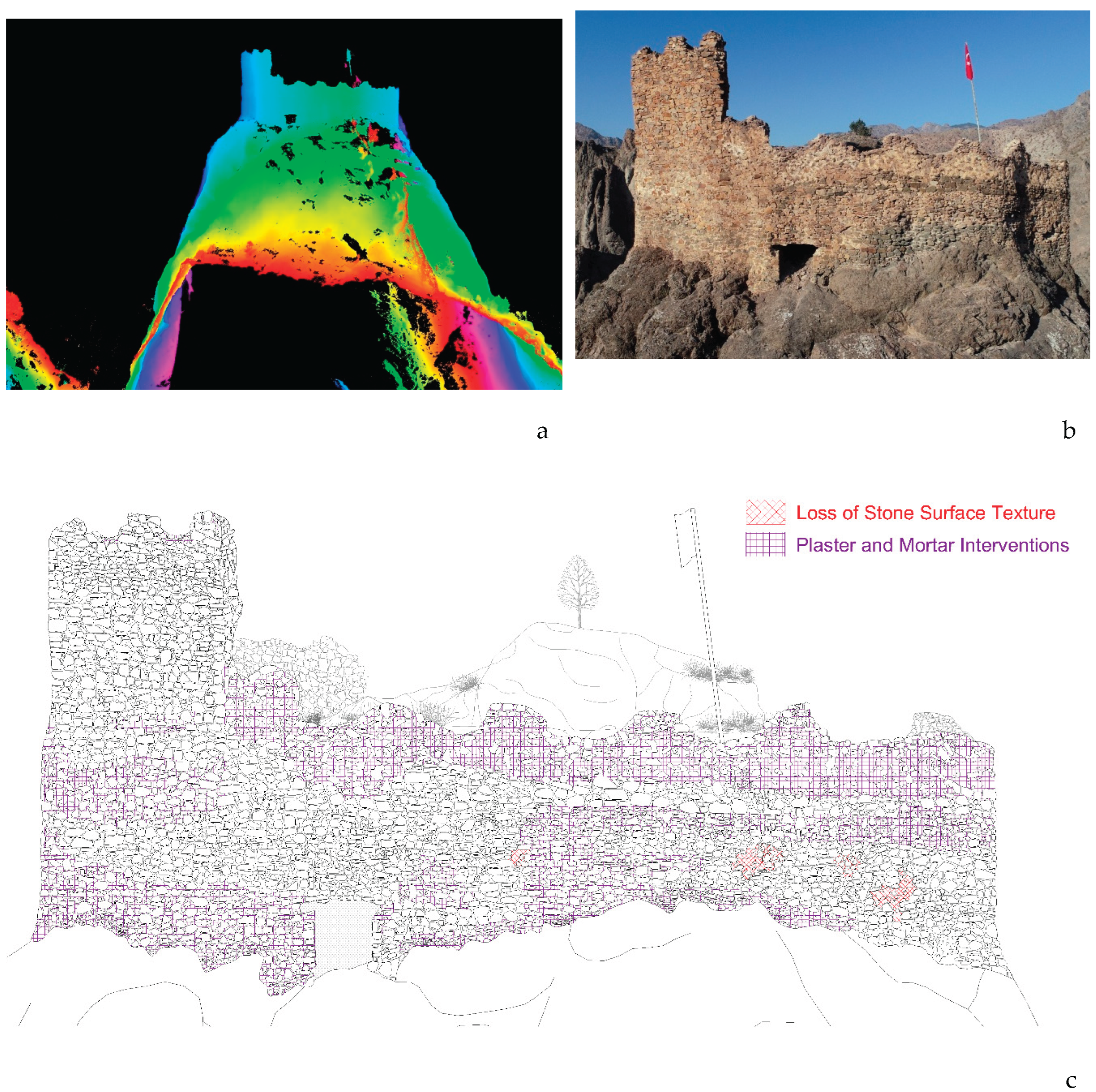
The integrated documentation panel for Bahçeli Castle enables a combined reading of the structure’s current physical condition and the traces of post-dam contextual transformation. The laser scanning–based surface model illustrates the castle’s relationship with the surrounding topography and surface continuity, while field photographs document material loss, crack development, and surface deterioration. The full-elevation deterioration map further visualizes the spatial distribution of deterioration types, including stone surface loss and mortar or plaster interventions, providing a reference base for the material sensitivity and risk assessments developed in subsequent sections.
In contrast, the documentation panel of Çevreli (Peterek) Castle more clearly exposes the impacts of post-dam landscape transformation on the castle–valley relationship, access continuity, and surface deterioration patterns. The interaction between the castle’s topographic position and reconfigured transportation axes, together with observed stone surface deterioration, establishes a comparative framework for the subsequent risk and vulnerability analyses (Figure 4).
The documentation panel prepared for Kılıçkaya (Ersis) Castle enables an integrated reading of the defensive structure’s direct relationship with the bedrock and the ways in which this relationship has been transformed by post-dam microclimatic and geotechnical risks. The visual set particularly supports the interpretation of risk indicators through observed crack development, rock surface deterioration, and access fragmentation, providing an analytical basis for the subsequent assessment stages (Figure 5).
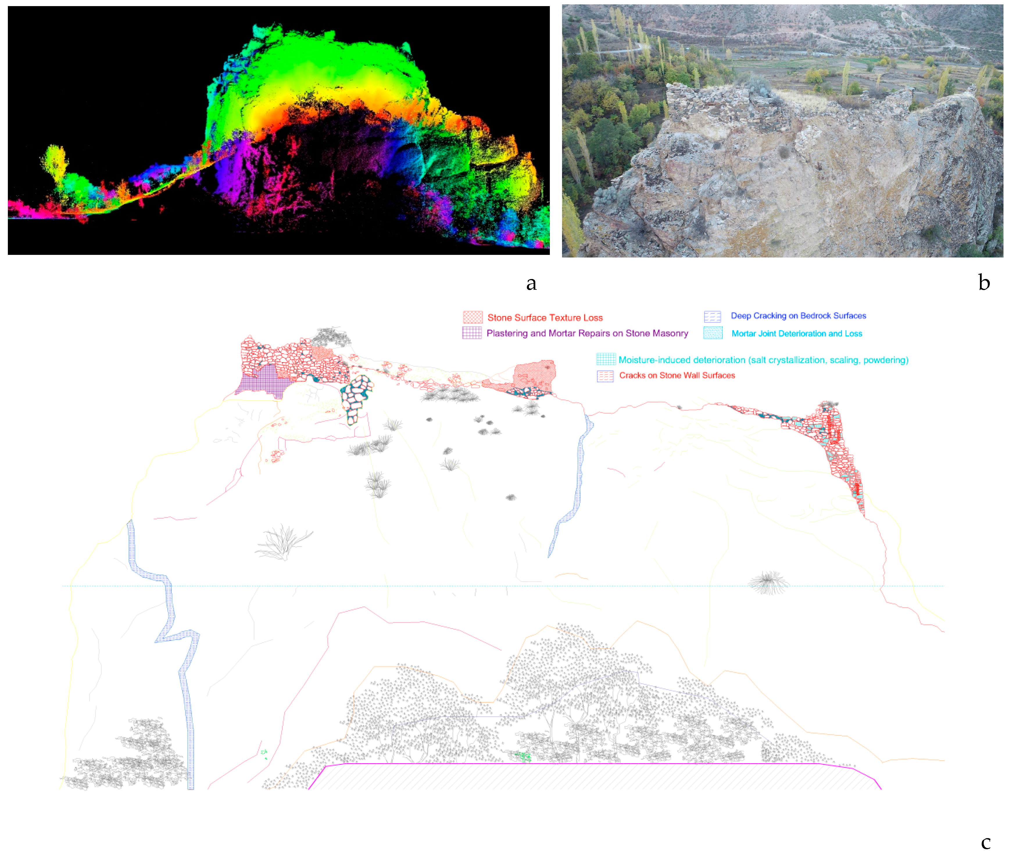
Figure 5.
Integrated documentation panel of Kılıçkaya Castle showing (a) laser-scanning–derived surface model (D-RGB) and field photograph, and (b) full-façade deterioration mapping illustrating cracks on stone wall surfaces, deep cracks on rock surfaces, loss of stone surface texture, plaster and mortar interventions on stone surfaces, mortar joint erosion/loss, and moisture-related deterioration (salt crystallization, scaling, powdering).
The documentation panel of Kınalıçam (Asparaşeni) Castle illustrates how physical deterioration, contextual disruption, and data limitations are addressed simultaneously in a case with more restricted documentation resources. This presentation provides a concrete example of why data completeness (DCI) is treated as a separate evaluative layer within the proposed model, making the implications of data gaps explicit in the assessment process (Figure 6).
The documentation panels prepared for the four castles allow a comparative reading of the impacts of the post-dam artificial reservoir landscape, reconfigured access routes, and altered topographic conditions on rural defensive structures. At this stage, not only physical deterioration types, surface loss, and traces of past interventions are identified, but also disruptions to visual dominance, access relationships, and landscape continuity that are fundamental to the castles’ original defensive logic.
The visual documentation presented in this section establishes a common reference point for the subsequent assessments of anthropogenic risk (AR), topographic–contextual vulnerability (TC), and material sensitivity (MS). As a result, numerical scores and prioritization outputs are interpreted not as abstract values, but in direct relation to observable spatial and material evidence.
3.2. Summary of Module-Based Scores (AR, TC, MS, DCI) and Comparative Logic
This subsection summarizes the scores derived from the AR, TC, MS, and DCI modules for the investigated castles and outlines the logic of inter-module comparison. Its purpose is to provide a reference framework for the detailed analyses presented in the following subsections and to render each castle’s risk profile immediately legible.
Scores are reported at two levels. The first level consists of individual module scores: AR represents a risk-based measure derived from impact and probability values; TC reflects the translation of post-dam landscape transformation into contextual vulnerability; MS evaluates intervention decisions through material compatibility; and DCI indicates data completeness and evidential strength. The second level involves the conversion of these module scores into a single priority ranking through normalization and aggregation. Accordingly, the summary table is structured to allow parallel reading of individual module values and the resulting composite index.
In this study, TC, MS, and DCI are defined within a 0–1 range and are therefore directly comparable. As AR is initially scored on a 1–3 scale, it is normalized to a 0–1 range to ensure inter-module comparability. Because MS follows a compatibility-based logic, it is transformed into a risk-oriented variable for prioritization purposes and expressed as 1 − MS. This transformation prevents high compatibility scores from generating artificial urgency while ensuring that incompatible interventions are directly reflected in the composite priority calculation.
The absence of MS data for certain castles is not treated as a concealed limitation, but is explicitly represented through the DCI. Interpretation therefore relies on a two-dimensional reading of PI (priority) and DCI (confidence). High PI values combined with low DCI values indicate the need to prioritize data completion and rapid risk-reduction measures before comprehensive intervention. Conversely, when both PI and DCI are high, the model demonstrates that sufficient analytical grounds exist for the implementation of defined intervention packages.
The summary table presented in this subsection comparatively illustrates the risk and vulnerability profiles of the four castles based on the AR, TC, MS, and DCI modules. The Composite Priority Index (PI) expresses intervention urgency, while the Data Completeness Index (DCI) defines the evidential reliability of that priority. The following subsection examines the first key component shaping the priority index, the anthropogenic risk module (AR), in detail for each castle.
Table 3.
Material sensitivity (MS) assessment of the castles based on documented deterioration patterns and available material analysis data.
Table 3.
Material sensitivity (MS) assessment of the castles based on documented deterioration patterns and available material analysis data.
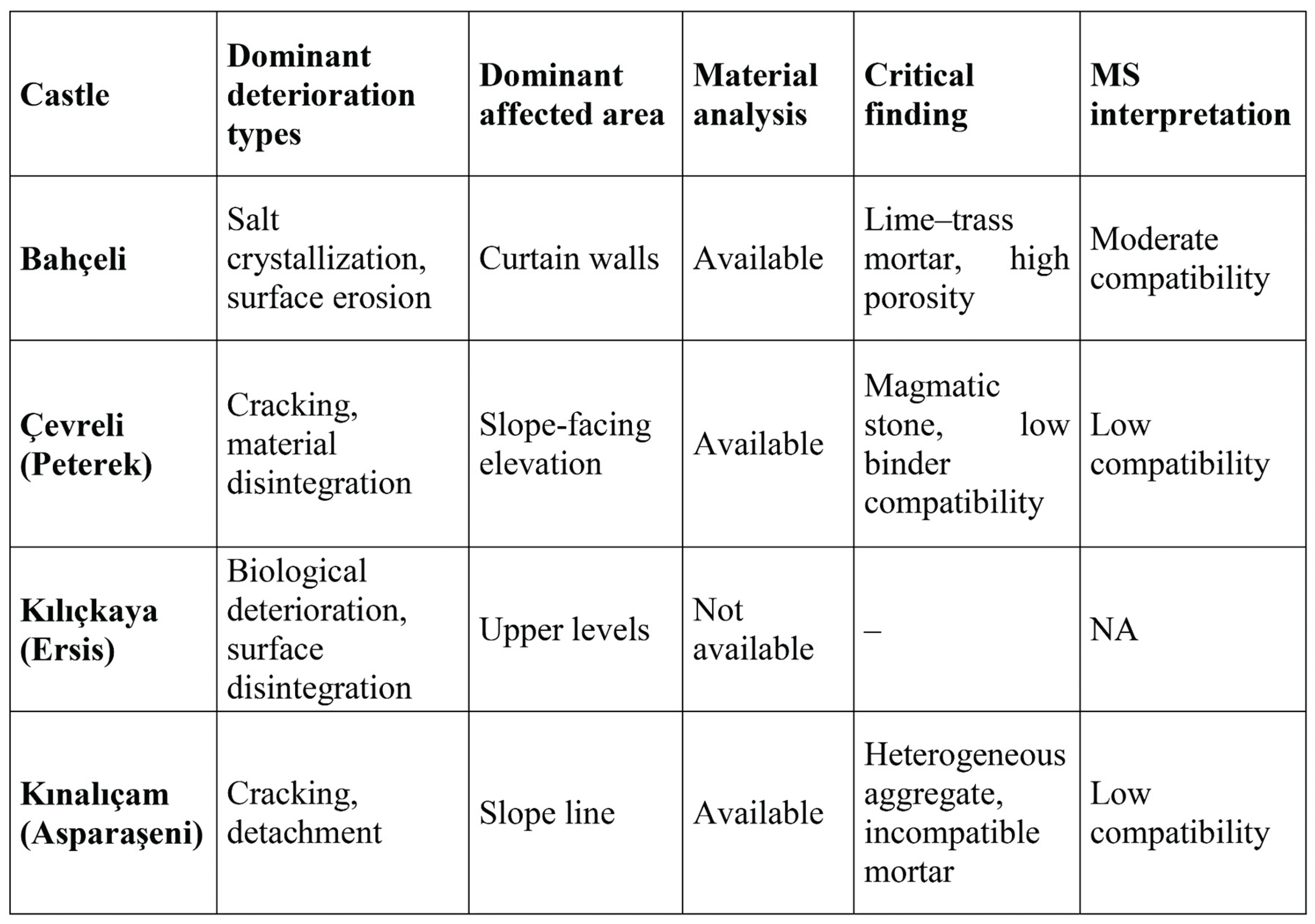
The MS score was calculated only for castles for which laboratory-based material characterization data were available. As no such data exist for Kılıçkaya Castle, the MS module was not calculated for this case; instead, this limitation is explicitly reflected in the decision confidence level through the DCI module.
3.3. Anthropogenic Risk Module (AR): Threat Types and Site-Based Assessment
The anthropogenic risk module (AR) evaluates, within a comparable analytical framework, human-induced and human-triggered threats affecting both the physical integrity and functional legibility of rural defensive structures. Risk is defined through the combined assessment of impact severity and probability of occurrence, enabling the identification of both existing damage conditions and plausible short- to medium-term deterioration scenarios.
The classification of anthropogenic risk levels as low, medium, and high is derived from the internal logic of the applied risk matrix rather than from arbitrary threshold selection. Risk values are calculated through the combination of impact and probability scores, producing clustered ranges that naturally correspond to differentiated risk conditions. Low-risk values reflect limited and localized effects with low likelihood, while high-risk values represent the convergence of severe impacts and high probability of occurrence. This approach follows established risk assessment principles in which risk classes emerge from impact–probability matrices, as commonly applied in heritage risk management and broader ISO 31000–based assessment frameworks. Accordingly, the adopted thresholds reflect structured risk logic, not subjective categorization.
Within this study, the AR module comprises four principal threat categories:
(A) microclimatic processes and salt crystallization,
(B) new road construction and vibration effects,
(C) vandalism and illicit excavations, and
(D) geotechnical risks, including landslides and rockfall.
These threats were assessed using deterioration and intervention maps, field observations, topographic and geomorphological analyses, and transportation network readings. For each threat type, impact and probability were scored on a 1–3 scale, and site-based risk values were calculated through their multiplication, forming the basis of the AR module.
The assigned impact and probability scores are not derived from isolated or purely subjective judgments. Rather, they are grounded in the combined interpretation of documented deterioration patterns, spatial positioning, accessibility conditions, and the intensity of ongoing human activities. Within this framework, AR scores function as relative indicators designed to establish a comparative risk profile among the castles examined within the same regional context.
Table 4.
Anthropogenic risk (AR) module: threat types, impact and probability scores, and site-based AR results.
Table 4.
Anthropogenic risk (AR) module: threat types, impact and probability scores, and site-based AR results.
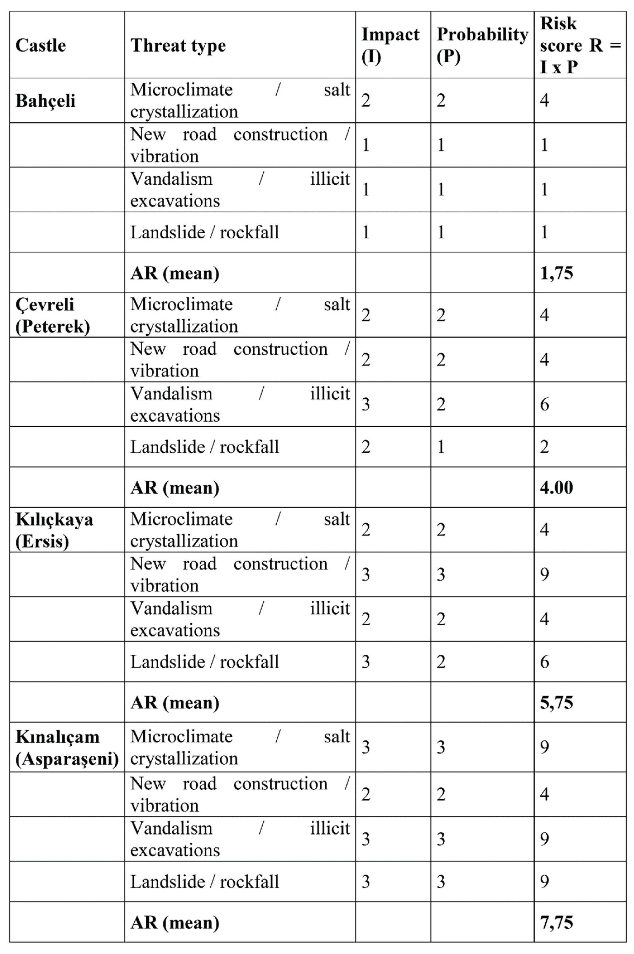
- Impact (I) and Probability (P) values are defined on a scale from 1 (low) to 3 (high).
- The site-based AR value is calculated as the arithmetic mean of the risk scores computed for the identified threat types.
- Scores are derived from field observations, deterioration mapping, transport network analysis, and topographic assessments.
Impact and probability scores were assigned for each threat type based on indicators documented through deterioration maps, field observations, and accessibility analyses. Scoring was conducted independently by two researchers, and discrepancies were resolved through consensus. To enable the quantitative comparison of anthropogenic risks, the impact and probability scores assigned to the identified threat types for each fortress were combined. The resulting AR (Anthropogenic Risk) values, calculated on the basis of field observations, deterioration mapping, and topographic and accessibility analyses, are presented below (Figure 7).
Figure 7 presents the anthropogenic risk (AR) components and average AR scores calculated for the surveyed castles. Impact–probability–based risk scores are shown for four main threat categories: microclimate/salt crystallization, new road construction and vibration, vandalism/illegal excavations, and landslide/rockfall hazards. The colour scale represents low (1), medium (2–4), and high (6–9) risk levels. The average AR value is calculated as the arithmetic mean of the individual threat scores defined for each castle.
The anthropogenic risk profile of Bahçeli Castle is primarily shaped by post-dam microclimatic changes and associated salt crystallization processes. Alterations in humidity conditions create favourable environments for salt-related deterioration on stone and mortar surfaces. Nevertheless, the castle’s topographic position currently limits large-scale geotechnical risks. Road-related vibration effects remain minimal, while vandalism and unauthorised interventions are assessed as localized and largely controllable. Accordingly, Bahçeli Castle exhibits a moderate AR score relative to the other case studies.
At Çevreli (Peterek) Castle, anthropogenic risks display a more complex and intensified structure. The proximity of newly developed transportation routes and increased human activity along the valley floor substantially elevate the risks of vandalism and unauthorised interventions. The spatial concentration of these impacts, as documented in the deterioration maps, indicates that such risks are already active rather than merely potential. Although microclimatic effects are comparable to those observed at Bahçeli Castle, increased accessibility and limited control mechanisms result in a higher overall AR profile.
For Kılıçkaya (Ersis) Castle, anthropogenic risk is dominated by road-related impacts and associated vibration effects. Post-dam reconfiguration of transportation corridors has increased heavy vehicle traffic in close proximity to the structure, contributing to crack development and the amplification of existing structural vulnerabilities. In addition, the castle’s steep, rock-based topographic setting heightens exposure to localized rockfall and landslide hazards. The convergence of these factors places Kılıçkaya Castle among the high-risk cases within the AR module.
Kınalıçam (Asparaşeni) Castle represents the most critically exposed case in terms of anthropogenic risk. Geotechnical observations indicate increasing landslide and rockfall hazards along the slope supporting the structure, closely linked to post-dam landscape transformation and altered land-use patterns. Insufficient monitoring and uncontrolled human activity in the surrounding area further intensify risks related to vandalism and secondary interventions. As a result, the AR module identifies Kınalıçam Castle as a critical-risk site characterized by the convergence of high-impact and high-probability threats.
Overall, the AR module demonstrates that anthropogenic risk is unevenly distributed across the four castles and is strongly conditioned by post-dam landscape configuration, accessibility, and topographic context. When interpreted alongside the Topographic–Contextual Vulnerability (TC) module, these findings confirm that risk emerges not only from the physical properties of the structures themselves, but also from their altered spatial relationships with the surrounding landscape.
3.4. Contextual Vulnerability Module (TC): Post-Dam Landscape Transformation and Spatial Disruptions
The contextual vulnerability module (TC) evaluates the extent to which the spatial, visual, and functional relationships between rural defensive structures and their surrounding environments have been weakened by post-dam landscape transformation, independently of physical integrity. Rather than focusing on building-scale damage, this module conceptualizes risk through the disruption of the structure–landscape–access system that originally sustained the defensive logic of the castles.
The TC module is operationalized through four indicators:
(A) disruption of visual dominance (V),
(B) breakdown of access continuity (A),
(C) landscape fragmentation (L), and
(D) microclimatic exposure (M).
These indicators are derived from laser-scanning-based topographic readings, transportation network analyses, and systematic field observations. For each castle, normalized scores between 0 and 1 were calculated, enabling direct comparison across cases and allowing post-dam contextual change to be assessed within a semi-quantitative analytical framework.
At Bahçeli Castle, contextual vulnerability remains relatively limited. The site lies outside the immediate influence zone of the reservoir and retains a substantial degree of its historical valley relationships. However, post-dam microclimatic alterations and changes in local humidity conditions are identified as emerging contextual risks with potential long-term implications for material performance. Access continuity and visual dominance largely preserve their historical coherence.
For Çevreli (Peterek) Castle, the TC module reveals a more pronounced vulnerability pattern. Transformation of the valley floor has weakened historical visual relationships, while newly established transportation axes have displaced original access routes. Although the structure remains physically intact, its spatial legibility as a defensive installation has been significantly reduced. Landscape fragmentation constitutes the dominant component shaping the TC score for this site.
In the case of Kılıçkaya (Ersis) Castle, contextual vulnerability is concentrated primarily in access-related and topographic indicators. Post-dam reconfiguration of transportation infrastructure has rendered historical approach systems largely obsolete. Combined with the castle’s steep slope setting, this has produced a rupture in both access continuity and visual dominance, substantially weakening the readability of its defensive logic and resulting in high TC values.
Kınalıçam (Asparaşeni) Castle represents the most severe case of contextual loss within the TC framework. The artificial reservoir landscape has largely eliminated the castle’s former valley relationships, rendering original sightlines and defense-oriented spatial configurations ineffective. Severe landscape fragmentation and the breakdown of access continuity are the principal drivers of its elevated contextual vulnerability. This case clearly demonstrates that the preservation of physical fabric alone is insufficient, as the loss of contextual relationships directly undermines historical and cultural significance.
Overall, the TC module confirms that post-dam landscape transformation constitutes a primary driver of vulnerability for rural defensive heritage rather than a secondary or indirect effect. When read alongside the Anthropogenic Risk (AR) module, the findings underscore the necessity of defining intervention priorities not solely on the basis of physical deterioration, but also through the assessment of spatial and functional disruptions. The following subsection examines how these contextual vulnerabilities intersect with material performance and intervention compatibility within the Material Sensitivity (MS) module.
3.5. Material–Intervention Compatibility Module (MS): Evaluation of Original Material Characteristics and Intervention Decisions
The Material–Intervention Compatibility module (MS) evaluates the extent to which existing or proposed conservation interventions are compatible with the original material characteristics of rural defensive structures. Compatibility is not defined solely through chemical or physical similarity, but through the relationship established between intervention materials and the original construction logic in terms of permeability, durability, and long-term material behaviour. The primary aim of the MS module is to identify interventions that may appear structurally “strengthening” in the short term yet generate secondary risks such as moisture entrapment, salt crystallization, and accelerated surface loss over time.
In this study, the MS assessment is based on an integrated interpretation of laboratory-based material analyses, field observations, and available documentation concerning previous or proposed interventions (Figure 8). Petrographic and X-ray diffraction (XRD) analyses conducted on mortar and stone samples provide data on binder–aggregate relationships, mineralogical composition, and material fabric. These analytical results are not treated as descriptive outputs, but as reference criteria against which the compatibility of intervention materials is evaluated.
For mortar characterization in particular, the technical literature emphasizes that reliable interpretation depends on the combined reading of mineralogical, petrographic, and compositional data rather than isolated test results (RILEM TC 203-RHM, 2009). Accordingly, the MS module adopts a holistic assessment logic in which laboratory findings are translated into decision-oriented indicators linked directly to intervention suitability and long-term performance. This approach enables the identification of incompatible repair strategies that may disrupt original material behaviour, even when such interventions are visually discreet or conventionally accepted in practice.
Within the prioritization framework of the model, higher MS values indicate greater material compatibility and, therefore, lower conservation risk. Conversely, low compatibility scores signal intervention strategies that may compromise the physical integrity and durability of the structure over time. For this reason, the MS module does not function as an isolated material assessment tool, but as a critical bridge between analytical data and conservation decision-making, ensuring that intervention priorities are informed not only by risk exposure and contextual vulnerability, but also by material behaviour and compatibility principles.
These report pages are presented as illustrative examples to demonstrate the evidence base underlying the fields “analysis available/not available,” “critical finding,” and “MS interpretation” transferred to the MS module in Table 5. The experimental and documentary data enable the combined evaluation of dominant deterioration types, availability of analytical data, and intervention compatibility for each castle. The table presented below clearly distinguishes between cases with and without material analyses, thereby summarizing in a comparative manner the level of evidence on which MS module interpretations are based (Table 5).
At Bahçeli Castle, material analysis results indicate that the original mortar system is lime-based with a relatively balanced aggregate distribution. When these findings are evaluated together with field observations and available intervention records, both implemented and proposed interventions appear largely compatible with the original material character. No significant adverse effects are observed in terms of vapor permeability or mechanical interaction with the historic fabric. Accordingly, the MS assessment for Bahçeli Castle indicates a high level of material–intervention compatibility.
At Çevreli (Peterek) Castle, laboratory analyses confirm that the original material system is predominantly lime-based. However, field observations document the use of harder and less permeable repair mortars in certain areas. While such interventions may provide short-term structural reassurance, they introduce a risk of incompatibility that may lead to moisture accumulation and enhanced salt crystallization over time. On this basis, the MS module identifies a moderate level of material–intervention compatibility for Çevreli Castle.
At Kınalıçam (Asparaşeni) Castle, material analyses reveal a heterogeneous original fabric characterized by a sensitive balance with environmental conditions. When laboratory findings are interpreted alongside field data, it becomes evident that the materials used in proposed or locally implemented interventions fail to adequately respect this balance. In particular, incompatibility risks related to excessive binder stiffness and reduced vapor permeability are identified. Consequently, the MS module assigns a low compatibility level to Kınalıçam Castle.
For Kılıçkaya (Ersis) Castle, the absence of laboratory-based material characterization data prevents the quantitative calculation of the MS module. Rather than being normalized or concealed, this limitation is explicitly addressed through the Data Completeness Index (DCI). As a result, the evaluation of intervention compatibility for Kılıçkaya Castle is confined to qualitative field observations, and the absence of a numerical MS score is maintained as a deliberate methodological choice in favor of transparency.
Overall, the results of the MS module demonstrate that material–intervention compatibility is not a secondary technical concern but a critical factor that directly influences risk assessment and prioritization outcomes. In contexts where anthropogenic risk (AR) and contextual vulnerability (TC) are elevated, incompatible interventions may act as risk multipliers by accelerating deterioration processes. For this reason, MS findings must be interpreted in conjunction with AR and TC rather than in isolation. The following subsection addresses the uncertainty dimension of these assessments and their evidential robustness through the Data Completeness Index (DCI).
3.6. Data Completeness and Uncertainty Dimension (DCI): Reliability of Results and Definition of Decision Boundaries
The Data Completeness Index (DCI) is designed to explicitly indicate the level of evidence supporting the results produced by the proposed assessment model. Rather than presenting risk and priority scores as definitive outcomes, the DCI reveals the extent to which these scores are grounded in documentation, analytical data, and measurement-based evidence. In this way, the model functions not only as a prioritization tool but as a decision-support framework that explicitly manages uncertainty.
DCI values are calculated by evaluating both the scope and quality of available datasets for each castle. Key inputs include the presence of laser scanning data, the completeness of survey drawings and deterioration maps, topographic modelling outputs, and the availability of laboratory-based material analyses. These datasets are weighted according to their relevance for conservation decision-making, and DCI values are expressed on a 0–1 scale to ensure comparability with other modules.
For Bahçeli Castle, the DCI indicates high data completeness. The availability of laser scanning documentation, detailed deterioration mapping, and laboratory-based material analyses provides a strong evidential basis for the AR, TC, and MS scores. As a result, prioritization and intervention decisions for this castle can be approached with a relatively high degree of confidence.
At Çevreli (Peterek) Castle, data completeness is also high, although slightly reduced due to the more limited scope of certain material- and intervention-related datasets. Nevertheless, the available evidence sufficiently supports the main risk and contextual vulnerability indicators, allowing prioritization outcomes to be interpreted within a reliable analytical framework.
For Kınalıçam (Asparaşeni) Castle, the DCI reflects a moderate level of data completeness. While spatial datasets such as laser scanning outputs and deterioration maps are available, the limited extent of material characterization requires that MS-related findings be interpreted with caution. When considered alongside the high risk and vulnerability scores identified for this castle, this condition underscores the need for targeted data completion prior to major interventions.
Kılıçkaya (Ersis) Castle exhibits the lowest level of data completeness. Although laser scanning data and deterioration maps exist, the absence of laboratory-based material analyses prevents the quantitative calculation of the MS module. This limitation is not concealed but explicitly articulated through the DCI, indicating that prioritization results for this castle should be interpreted under conditions of elevated uncertainty.
Overall, the DCI results demonstrate that data gaps are not a weakness of the model but a critical component of transparent decision-making. Castles with high Priority Index (PI) values but low DCI values should not be subject to immediate comprehensive interventions. Instead, priority should be given to data completion accompanied by rapid risk-reduction measures. The following subsection integrates the AR, TC, MS, and DCI results to present a synthesized evaluation based on the composite priority index and decision classes.
3.7. Synthesis of the Composite Priority Index (PI) and Decision Classes
This subsection integrates the outputs of the Anthropogenic Risk (AR), Contextual Vulnerability (TC), Material–Intervention Compatibility (MS), and Data Completeness (DCI) modules to produce a Composite Priority Index (PI) for each castle. The PI consolidates heterogeneous risk and vulnerability components within a common evaluative scale, enabling conservation priorities to be assessed through a transparent and comparable multi-criteria framework rather than through isolated or intuitive judgments.
In the PI calculation, AR values are normalized to a 0–1 range, while TC and MS are used directly as comparable scores. Because the MS module reflects compatibility rather than risk, its values are inverted (1 − MS) so that material incompatibility is incorporated as a risk component. The DCI is not included in the PI calculation itself but is treated as a second analytical axis, allowing priority levels and confidence in the results to be interpreted simultaneously.
The synthesis reveals clearly differentiated priority profiles among the four castles. Kınalıçam (Asparaşeni) Castle emerges as the highest-priority case, combining high AR and TC values with low MS compatibility and a moderate DCI score. This configuration reflects both the urgency of the risks affecting the site and the need for carefully structured intervention strategies, particularly in relation to contextual rupture and geotechnical instability.
Kılıçkaya (Ersis) Castle occupies a distinct decision category. Although it displays high anthropogenic risk and contextual vulnerability, its low DCI indicates limited evidential support for comprehensive intervention. Accordingly, the model prioritizes targeted documentation and data completion for this site before large-scale conservation actions are undertaken. This outcome demonstrates that the model differentiates not only levels of risk, but also appropriate types of action.
Çevreli (Peterek) Castle is positioned within the planned intervention category, characterized by medium-to-high AR and TC values, moderate MS compatibility, and a relatively high DCI. For this site, phased and monitorable conservation strategies are recommended rather than immediate large-scale intervention. The Çevreli case illustrates that contextual vulnerability can significantly influence prioritization independently of visible physical damage.
By contrast, Bahçeli Castle exhibits the lowest priority level, with relatively low AR and TC values, high MS compatibility, and a high DCI score. These results indicate that monitoring and preventive maintenance are sufficient under current conditions, demonstrating the model’s capacity to identify not only high-risk structures but also relatively stable heritage assets.
When PI and DCI are evaluated together, the model generates four primary decision classes:
(1) urgent intervention,
(2) planned intervention,
(3) data completion priority, and
(4) monitoring-oriented management.
This classification supports the transparent and justifiable allocation of limited conservation resources and positions the proposed model as an operational decision-support system rather than a purely analytical exercise.
The results confirm that conservation decision-making for rural defensive heritage under post-dam transformation pressures requires the integrated evaluation of multi-dimensional risk and vulnerability components. The following section situates these findings within the broader conservation literature, focusing on the model’s contributions, limitations, and potential transferability.
4. Discussion
This section situates the findings and the proposed evaluation model within the broader literature on risk-based conservation, contextual vulnerability, and decision-support approaches in cultural heritage studies.
4.1. Comparison with the Literature: Risk, Context, and Decision-Support Approaches
Risk assessment and conservation prioritization approaches in cultural heritage research have traditionally focused on measurable physical parameters, including structural damage, material deterioration, and natural hazards. Engineering-based vulnerability models have been particularly effective in quantifying such risks through numerical indicators. However, most of these models treat the spatial relationships between heritage structures and their surroundings, as well as their representational and contextual values, as secondary considerations. As a result, heritage structures that remain physically intact but experience substantial degradation of their topographic, visual, or functional context are often inadequately represented within conventional risk profiles.
The multi-modular assessment model proposed in this study addresses these limitations at two principal levels. First, anthropogenic risks are evaluated through a structured framework combining impact severity and probability, rather than being described as isolated qualitative threats. This approach enables a more comparable and decision-oriented prioritization process, particularly for rural defensive heritage where environmental and human-induced pressures intersect. Second, the formulation of contextual vulnerability (TC) as an independent module allows the identification of risk conditions affecting structures whose physical fabric remains largely preserved but whose spatial, visual, and functional relationships have been substantially disrupted.
In much of the existing literature, contextual evaluations remain predominantly qualitative. Relationships involving topography, access, and landscape are frequently acknowledged but rarely translated into systematic quantitative or semi-quantitative assessment models. The TC module developed in this study responds to this gap by operationalizing contextual vulnerability through laser-scanning data, topographic readings, and access analyses. In this way, context is transformed from an abstract interpretive notion into a measurable component that directly informs intervention priorities. This approach aligns with recent shifts in international conservation discourse emphasizing cultural landscape, indirect impacts, and context-sensitive assessment beyond fabric-focused methodologies (UNESCO, 2011; ICOMOS, 2011).
Similarly, the integration of material–intervention compatibility (MS) into the risk framework enables the evaluation of long-term consequences associated with interventions that may appear technically effective in the short term but are materially incompatible with the original fabric. While material analyses are commonly presented in the literature as descriptive technical datasets, this study differentiates itself by embedding these analyses directly within prioritization and decision-making processes. The Data Completeness Index (DCI) further extends this logic by explicitly communicating uncertainty, ensuring that the evidential basis of assessment results remains transparent rather than implicit.
Rather than rejecting existing risk and vulnerability frameworks, the proposed model complements them through a contextual and epistemic expansion. It is specifically oriented toward rural landscapes undergoing rapid transformation as a result of large-scale infrastructure projects. Beyond asking how damaged a heritage structure is, the model addresses which knowledge base supports its assessment, with what level of confidence, and through which level of intervention it should be addressed. In doing so, it contributes a decision-support framework that bridges analytical assessment and responsible conservation practice.
4.2. Contributions and Distinctive Features of the Proposed Model
The evaluation model proposed in this study contributes to the conservation of rural defensive heritage at three principal levels: (1) the reconceptualization of risk within a multi-dimensional and contextual framework, (2) the explicit incorporation of data uncertainty into the assessment process, and (3) the translation of analytical results into action-oriented decision categories. A key methodological distinction of the model is its deliberate separation of intervention priority from evidential confidence, enabling risk ranking and decision reliability to be examined simultaneously but along distinct analytical axes.
The first distinctive feature of the model is its rejection of risk definitions based solely on physical damage and structural vulnerability. Through the combined use of the Anthropogenic Risk (AR) and Contextual Vulnerability (TC) modules, the model incorporates factors that are fundamental to the historical functioning of rural defensive structures, including topographic dominance, access continuity, and landscape integrity. This approach is particularly relevant in post-dam landscapes, where structures may remain physically intact while experiencing severe contextual disruption. In this respect, the model departs from much of the existing literature, which remains largely focused on building-scale fabric and material condition.
A second major contribution lies in the treatment of data insufficiency as an explicit analytical parameter rather than an implicit limitation. The Data Completeness Index (DCI) makes visible the extent to which prioritization outcomes are supported by documentation, measurement, and analytical evidence. By doing so, the model prevents assessment results from being interpreted as absolute or definitive and aligns more closely with real-world conservation practice, where decision-making under conditions of partial knowledge is unavoidable.
The third, and most practice-oriented, contribution of the model is its direct translation of analytical outputs into decision categories. The combined interpretation of the Composite Priority Index (PI) and DCI does not merely generate a ranking of sites, but provides a structured framework indicating which type of action is appropriate for each case. Categories such as urgent intervention, planned intervention, data completion, and monitoring transform what are often intuitive judgments into transparent and justifiable conservation decisions.
An additional distinguishing feature of the model is its capacity to integrate heterogeneous data types within a single hierarchical assessment structure. Laser scanning data, deterioration maps, material analyses, and field observations—typically produced in a fragmented manner by different disciplines—are unified through a shared decision-oriented logic. This integrative structure positions the model not only as an academic evaluation tool but also as a decision-support mechanism capable of facilitating communication across disciplinary and institutional boundaries.
Finally, the modular and transparent structure of the proposed framework enables adaptation to different geographical contexts and heritage typologies. Clearly defined indicators and weighting schemes allow the model to be recalibrated for other rural defensive structures, alternative infrastructure pressures, or comparable scenarios of contextual transformation. In this way, the study moves beyond a case-specific analysis of the Yusufeli region and contributes to broader discussions on conservation planning and decision support in rapidly transforming cultural landscapes.
4.3. Limitations, Uncertainties, and Transferability of the Model
Although the evaluation model proposed in this study provides a multi-dimensional framework for risk assessment and prioritization, it inevitably involves certain limitations and sources of uncertainty. Explicitly defining these limitations is essential both for the correct interpretation of the results and for assessing the model’s applicability beyond the Yusufeli case.
The first limitation concerns the uneven scope and depth of available data across the examined castles. In particular, the absence of laboratory-based material analyses for some cases restricted the quantitative calculation of the Material–Intervention Compatibility (MS) module. Rather than being concealed or normalized, this limitation is explicitly addressed through the Data Completeness Index (DCI), which renders data insufficiency analytically visible. In this way, uncertainty is not treated as an external weakness of the model but is incorporated as an integral component of result interpretation.
A second limitation derives from the inherently semi-quantitative nature of the Contextual Vulnerability (TC) indicators. Parameters such as visual dominance, access continuity, and landscape fragmentation, although supported by spatial analyses and field observations, cannot be fully reduced to universally objective metrics. Nevertheless, excluding context from comparative assessment altogether would create a far greater epistemic gap. The resulting uncertainty is therefore considered a conscious and manageable limitation rather than a methodological deficiency.
A third limitation relates to the context-sensitive character of the indicator sets and weighting schemes. The definitions of threats and evaluation logic applied within the Anthropogenic Risk (AR), Contextual Vulnerability (TC), and Material–Intervention Compatibility (MS) modules were developed in response to the post-dam transformation dynamics specific to the Yusufeli region. Consequently, the model cannot be transferred to other geographical contexts without recalibration. However, the modular structure of the framework transforms this constraint into a methodological advantage, as explicitly defined indicators can be adapted to different infrastructure pressures, climatic conditions, or heritage typologies without undermining the internal coherence of the model.
From a transferability perspective, the principal strength of the proposed framework lies not in producing universally fixed outcomes, but in offering a reproducible decision-making logic. The combined reading of AR, TC, MS, and DCI enables the model to operate under varying levels of data availability and institutional capacity. This flexibility positions the model not only as an academic assessment tool, but also as a decision-support instrument applicable by heritage authorities, local administrations, and conservation practitioners.
Finally, the model outputs represent a specific temporal snapshot. Given that post-dam landscape transformation is a dynamic and ongoing process, risk and vulnerability profiles are expected to evolve over time. For this reason, the model should be understood not as a static evaluation tool, but as a framework designed for periodic re-application. Such an approach supports adaptive conservation strategies and the long-term management of uncertainty.
4.4. Implications for Conservation Practice and Policy
The multi-modular evaluation model developed in this study should be understood not only as an analytical research tool, but also as an applied framework capable of informing conservation practice and policy-making. In rural landscapes transformed by large-scale infrastructure projects such as dams, heritage-related decisions are often taken under conditions of limited time, constrained budgets, and incomplete data. These constraints complicate prioritization processes and frequently result in reactive or ad hoc decision-making. The primary contribution of the proposed model lies in its capacity to translate this complex risk environment into comparable and defensible decision categories.
From the perspective of heritage councils and implementing institutions, the production of clearly defined decision classes—urgent intervention, planned intervention, data completion, and monitoring—enables assessment outcomes to be directly linked to action. This structure is particularly valuable in contexts where simultaneous and equal treatment of all heritage assets is neither feasible nor appropriate. By supporting transparent and traceable prioritization under resource constraints, the model shifts conservation decision-making away from intuition-driven practices toward analytically grounded and accountable processes.
At the policy level, a key implication of the model is its ability to make the indirect and cumulative impacts of large-scale infrastructure projects on cultural heritage visible at early stages. This approach aligns closely with the principles emphasized in Heritage Impact Assessment (HIA) frameworks promoted by UNESCO and ICOMOS, particularly those related to early identification of risk, comparative evaluation, and decision-support generation. Because the Anthropogenic Risk (AR) and Contextual Vulnerability (TC) modules address not only existing damage but also plausible future risk scenarios, the model supports preventive and anticipatory conservation strategies rather than purely reactive responses.
At the operational scale, the integrated use of laser scanning data, deterioration mapping, and material analyses encourages genuinely interdisciplinary working practices. By bringing together datasets typically produced by architecture, conservation, engineering, and planning disciplines within a single decision-oriented framework, the model helps reduce the fragmentation that often characterizes heritage assessments. In this respect, it offers not only a site-specific analytical tool, but also a mechanism for improving institutional coordination and communication.
Finally, the modular and flexible structure of the proposed approach positions it as an intermediate-scale instrument capable of bridging national conservation policies and international principles. The explicit definition of indicators and evaluation logic facilitates adaptation to different legislative and institutional contexts. Accordingly, the model should not be understood as a solution limited to the Yusufeli case, but as a transferable decision-support framework applicable to rural heritage sites exposed to dams, roads, and other large-scale infrastructural interventions.
5. Conclusions and Evaluation
This study proposes a multi-modular and reproducible decision-support framework for the conservation of rural defensive heritage exposed to dam-induced landscape transformation. By integrating Anthropogenic Risk (AR), Contextual Vulnerability (TC), Material–Intervention Compatibility (MS), and Data Completeness (DCI) within a unified analytical structure, the study demonstrates that conservation prioritization cannot be derived from physical condition alone. Instead, risk exposure, spatial and functional context, and the robustness of the evidential base must be evaluated together in order to support defensible and accountable conservation decisions.
The application of the model to the Yusufeli case study reveals clearly differentiated risk and vulnerability profiles among the four investigated castles—Bahçeli, Çevreli (Peterek), Kılıçkaya (Ersis), and Kınalıçam (Asparaşeni). The results indicate that certain structures attain high intervention priority despite retaining substantial physical integrity, primarily due to severe contextual and functional disruption under post-dam conditions. Conversely, other sites can be effectively managed through monitoring and preventive maintenance as a result of lower risk exposure combined with higher data completeness. These findings challenge conservation approaches that implicitly assume uniform urgency across heritage assets and underline the necessity of comparative, evidence-based prioritization frameworks.
A central contribution of the proposed model lies in its capacity to translate analytical assessments into action-oriented decision categories. The combined interpretation of the Composite Priority Index (PI) and the Data Completeness Index (DCI) defines not only which sites require intervention, but also what type of action is appropriate in each case. In this respect, the framework moves beyond simple ranking exercises and provides a structured basis for allocating limited conservation resources in a transparent and justifiable manner, shifting decision-making away from intuition-driven judgments toward traceable analytical reasoning.
The study explicitly acknowledges data incompleteness as an inherent condition of real-world conservation practice. Rather than concealing uncertainty, the integration of the DCI renders evidential limits visible and interpretable within the decision-making process. This approach enables more cautious and responsible conservation strategies by reducing the risk of implementing interventions that appear technically robust but rest on weak or partial evidence. Accordingly, the proposed framework should not be understood as a tool for mathematical optimization, but as a decision-support system designed to manage uncertainty while maintaining analytical clarity.
In summary, the study contributes to the conservation literature in three principal ways: (i) by developing an integrated framework that jointly addresses anthropogenic risk and contextual vulnerability in rural defensive heritage; (ii) by consolidating heterogeneous documentation, analytical, and field-based data within a shared decision-oriented structure; and (iii) by converting analytical outputs into directly applicable intervention and monitoring categories. Beyond the Yusufeli case, the proposed model offers a transferable and reproducible approach capable of supporting more transparent, accountable, and context-sensitive conservation decision-making in rural heritage landscapes affected by large-scale infrastructure projects.
Acknowledgments
This study is based on data produced by the author within the scope of architectural survey, documentation, and evaluation works conducted on the fortresses of Bahçeli, Çevreli (Peterek), Kılıçkaya (Ersis), and Kınalıçam (Asparaşeni), located in the Yusufeli district (Artvin). The author gratefully acknowledges the institutional framework provided by the Turkish Ministry of Culture and Tourism, General Directorate of Cultural Heritage and Museums, which enables the use of these data in scholarly publications in accordance with applicable regulations and contractual provisions.
Declaration of generative AI and AI-assisted technologies in the manuscript preparation process
During the preparation of this manuscript, the authors used ChatGPT (OpenAI) as an AI-assisted tool to support language editing, structural refinement, and the clarification of methodological descriptions. All analytical reasoning, data interpretation, methodological design, and final editorial decisions were carried out by the authors. The authors reviewed and revised all AI-assisted content and take full responsibility for the integrity, originality, and accuracy of the published work.
References
- Ashworth, G. J.; Graham, B.; Tunbridge, J. E. Pluralising pasts: Heritage, identity and place in multicultural societies. Pluto Press: London, UK, 2007. [Google Scholar]
- Australia ICOMOS. The Burra Charter: The Australia ICOMOS Charter for Places of Cultural Significance. Australia ICOMOS: Burwood, Australia, 2013. [Google Scholar]
- Belton, V.; Stewart, T. J. Multiple criteria decision analysis: An integrated approach. Springer: New York, NY, 2002. [Google Scholar]
- Beyhan, Ş. G.; Ünügür, S. M. Çağdaş gereksinmeler bağlamında sürdürülebilir turizm ve kimlik modeli. İTÜDERGİSİ/a 2010, 4(2). [Google Scholar]
- Fairclough, G.; Harrison, R.; Jameson, J. H.; Schofield, J. The heritage reader; Routledge: London, UK, 2018. [Google Scholar]
- Feilden, B. M. Conservation of historic buildings, 3rd ed.; Architectural Press: Oxford, UK, 2003. [Google Scholar]
- González-Varas Ibáñez, I. Conservación del patrimonio cultural. Teoría, historia, principios y normas. Cátedra. 2018. [Google Scholar]
- Harrison, R. Beyond “natural” and “cultural” heritage: Toward an ontological politics of heritage in the age of the Anthropocene. Heritage & Society 2015, 8(1), 24–42. [Google Scholar] [CrossRef]
- Historic England. Metric survey specifications for cultural heritage; Historic England: London, 2018. [Google Scholar]
- ICOMOS. Illustrated glossary on stone deterioration patterns. International Council on Monuments and Sites (ICOMOS–ISCS): Paris, France, 2008. [Google Scholar]
- ICOMOS. Guidance on heritage impact assessments for cultural World Heritage properties. International Council on Monuments and Sites: Paris, France, 2011a; Available online: https://openarchive.icomos.org/id/eprint/266.
- ICOMOS. The Valletta principles for the safeguarding and management of historic cities, towns and urban areas. International Council on Monuments and Sites: Paris, France, 2011b. [Google Scholar]
- International Organization for Standardization. ISO 31000:2018 Risk management — Guidelines. ISO: Geneva, Switzerland, 2018.
- International Organization for Standardization; International Electrotechnical Commission. ISO/IEC 31010:2019 Risk management — Risk assessment techniques. ISO/IEC: Geneva, Switzerland, 2019.
- Jokilehto, J. A history of architectural conservation. Butterworth-Heinemann: Oxford, UK, 1999. [Google Scholar]
- Kamacı, E. 2863 sayılı KTVKK’nın uluslararası yasal düzenlemeler bağlamında değerlendirilmesi. 2014. [Google Scholar] [CrossRef]
- Labadi, S. UNESCO, cultural heritage, and outstanding universal value: Value-based analyses of the World Heritage and Intangible Cultural Heritage Conventions. Rowman & Littlefield: Lanham, MD, 2017. [Google Scholar]
- Lang, D. M. The Georgians; Thames & Hudson: London, UK, 1966. [Google Scholar]
- Letellier, R.; Schmid, W.; LeBlanc, F.; Eppich, R.; Chabbi, A. Documentation, and Information Management for the conservation of Heritage Places. Guiding Principles. 2007. [Google Scholar]
- Rapp, S. H. The Sasanian world through Georgian eyes: Caucasia and the Iranian Commonwealth in late antique Georgian literature. Ashgate: Farnham, UK, 2014. [Google Scholar]
- RILEM Technical Committee 203-RHM. The testing of hardened mortars, a process of questioning and interpreting. Materials and Structures 2009, 42(7), 853–865. [Google Scholar] [CrossRef]
- Saaty, T. L. The analytic hierarchy process: Planning, priority setting, resource allocation. McGraw-Hill: New York, NY, 1980. [Google Scholar]
- Sezgin, S. K.; Sakcalı, G. B.; Özen, S.; Yıldırım, E.; Avcı, E.; Bayhan, B.; Çağlar, N. Reconnaissance report on damage caused by the February 6, 2023, Kahramanmaraş Earthquakes in reinforced-concrete structures. Journal of Building Engineering 2024, 89, 109200. [Google Scholar] [CrossRef]
- Şuta, O.; Zencirkıran, A. ANALYSIS OF SPATIAL ORGANIZATION IN ARCHITECTURAL WORKS OF KEMALEDDIN BEY USING SPACE SYNTAX: A CASE STUDY OF THE 4. VAKIF HAN. Gazi University Journal of Science Part B: Art Humanities Design and Planning 2024, 12(2), 161–172. [Google Scholar]
- Yeke, S. T. Historical electrical transformers in Bursa and the conservation of electrical industrial heritage. Journal of Architectural Conservation 2023, 29(3), 232–257. [Google Scholar] [CrossRef]
- TAPKI, S. TARİHİ KONUT YAPILARININ TURİZM İŞLEVİNE DÖNÜŞÜMÜNDE KİMLİĞİN BİLİMSEL AÇIDAN İZLENİMİ. Journal of History School 2024, 11(XXXIV), 1109–1131. [Google Scholar]
- Toumanoff, C. Studies in Christian Caucasian history. Georgetown University Press: Washington, DC, 1967. [Google Scholar]
- UNESCO. Recommendation on the Historic Urban Landscape. United Nations Educational, Scientific and Cultural Organization: Paris, France, 2011a; https://whc.unesco.org/en/hul. [CrossRef]
- UNESCO. Recommendation on the Historic Urban Landscape, including a glossary of definitions. United Nations Educational, Scientific and Cultural Organization: Paris, France, 2011b. [Google Scholar]
Figure 1.
Overview of the Yusufeli study area showing the spatial relationship between rural defensive heritage sites and the landscape transformation induced by the Yusufeli Dam.(a) Geopolitical distribution of the four investigated fortresses within the regional map of the Yusufeli district: Bahçeli, Çevreli (Peterek), Kılıçkaya (Ersis), and Kınalıçam (Asparaşeni).(b) Reservoir area formed after the filling of the Yusufeli Dam, illustrating the transformed valley morphology and the primary transportation axes (2024, Google Maps).
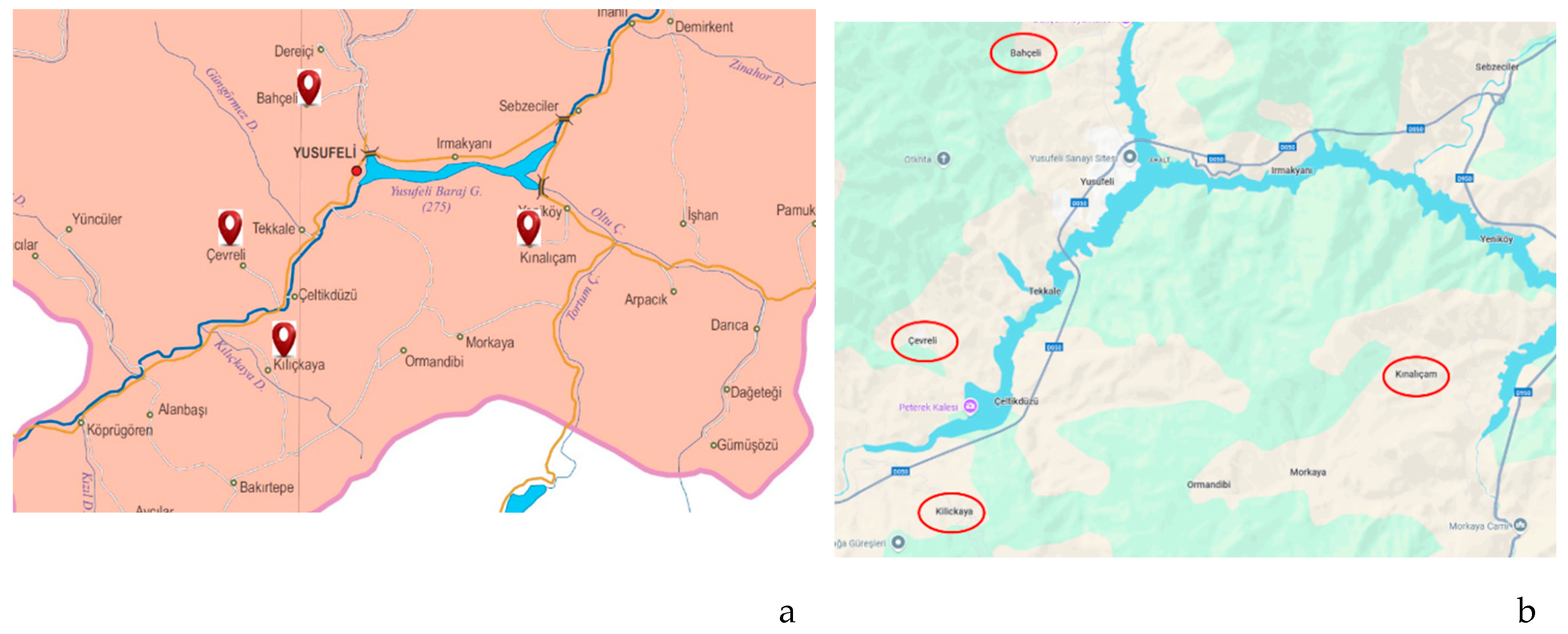
Figure 2.
Schematic representation of the integrated analytical approach adopted in this study, illustrating the identification, scaling, and selection of physical, socio-cultural, and documentary layers to be represented within the assessment framework.
Figure 2.
Schematic representation of the integrated analytical approach adopted in this study, illustrating the identification, scaling, and selection of physical, socio-cultural, and documentary layers to be represented within the assessment framework.
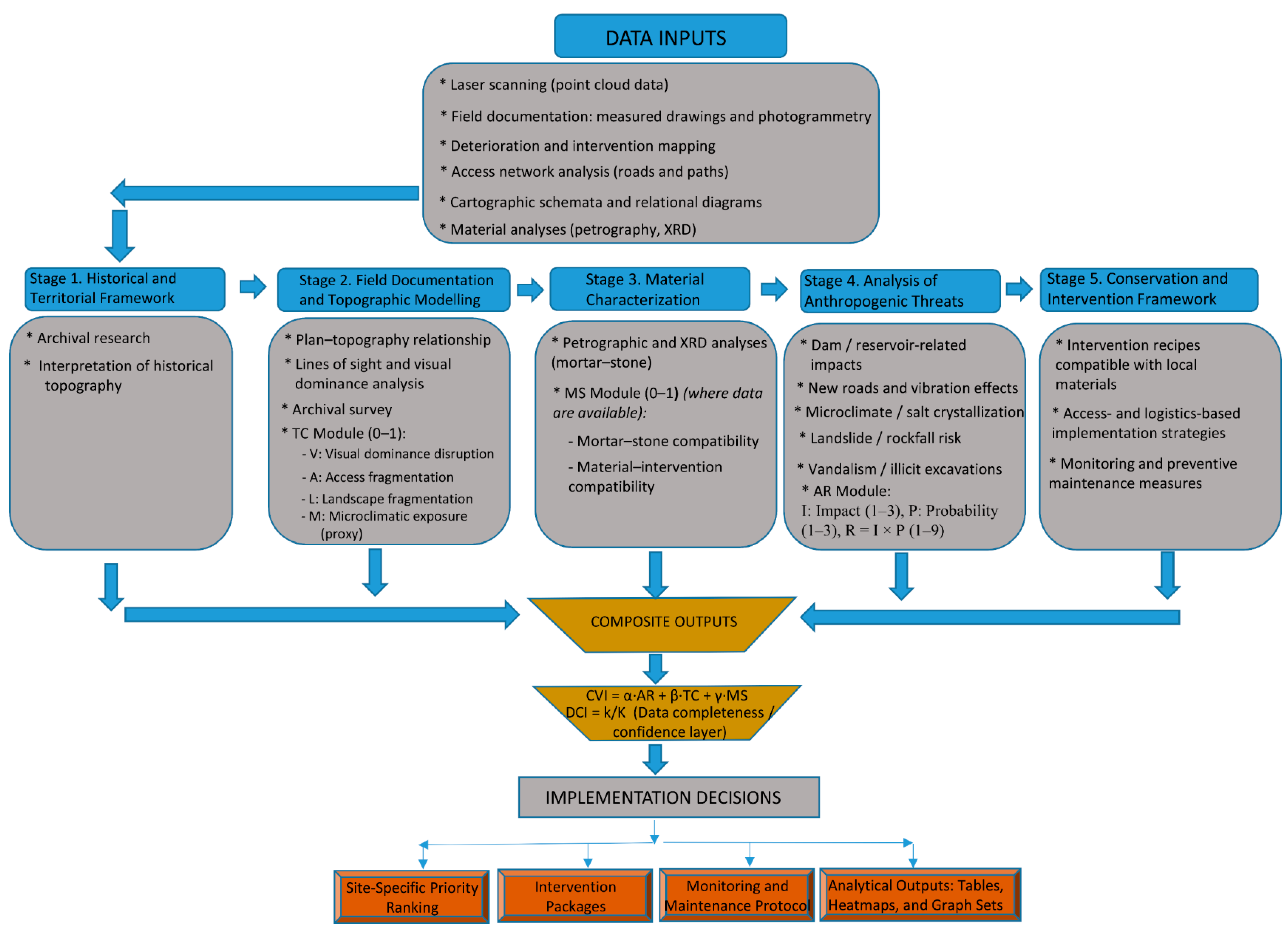
Figure 4.
Integrated documentation panel of Çevreli Castle showing (a) laser-scanning–derived surface model (D-RGB) and field photograph, and (b) full-façade deterioration mapping illustrating loss of stone surface texture, surface blackening, moss growth and vegetation, mortar joint erosion/loss, and moisture-related deterioration (salt crystallization, scaling, powdering).
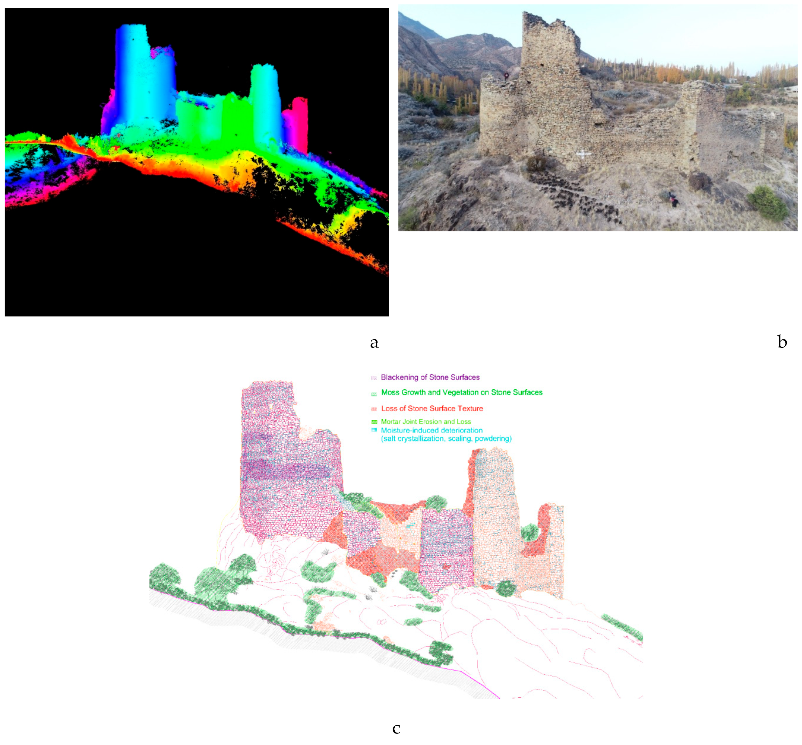
Figure 6.
Integrated documentation panel of Kınalıçam Castle showing (a) laser-scanning–derived surface model (D-RGB) and field photograph, and (b) full-façade deterioration mapping illustrating loss of stone surface texture, plaster and mortar interventions on stone surfaces, moss growth and vegetation, deep cracks on rock surfaces, and moisture-related deterioration.
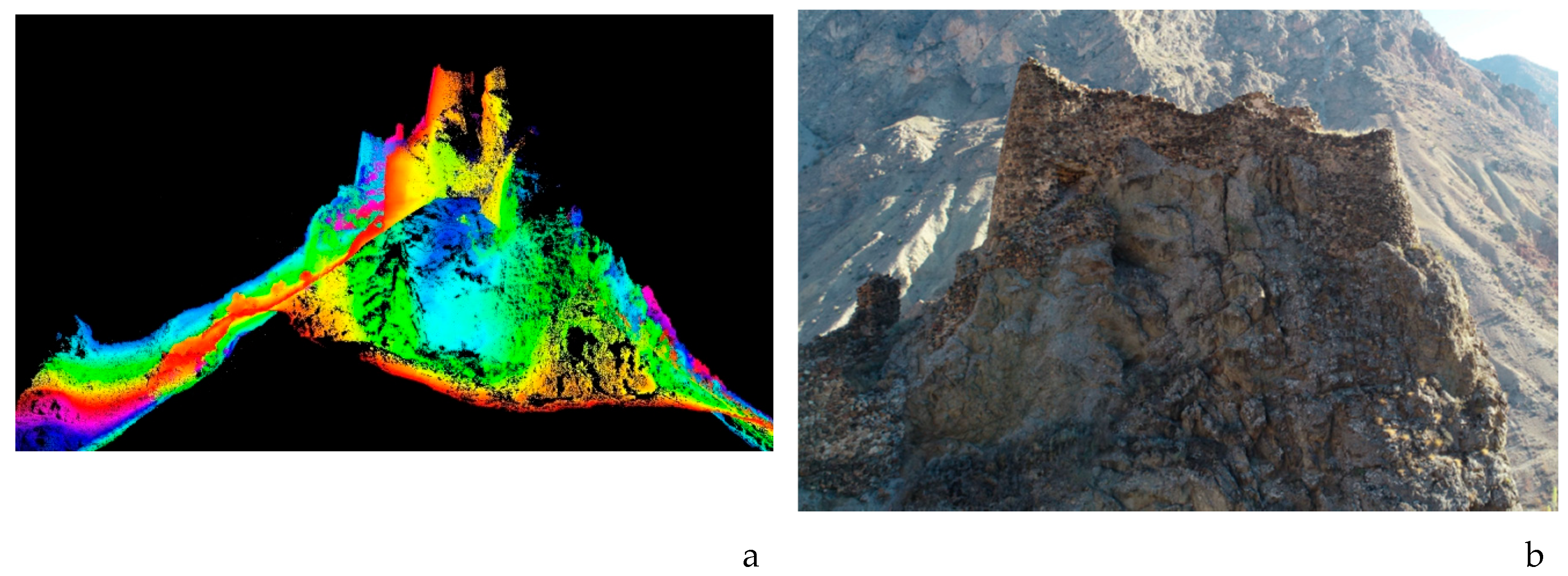
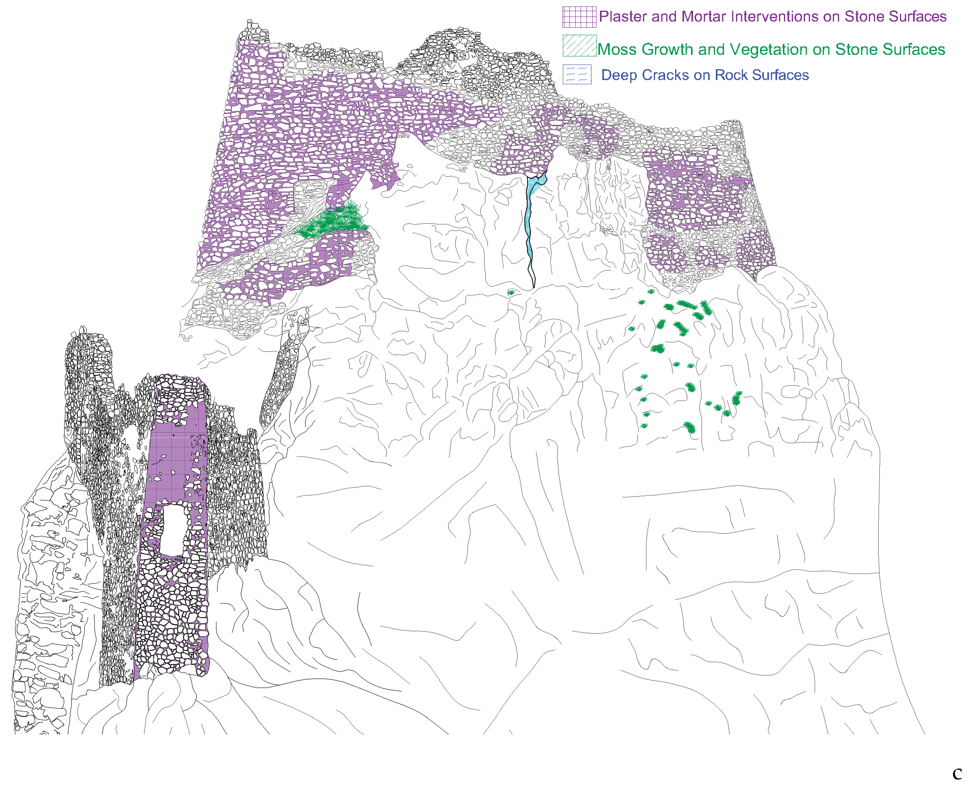
Figure 7.
Anthropogenic Risk (AR) components and average AR scores for the surveyed castles.
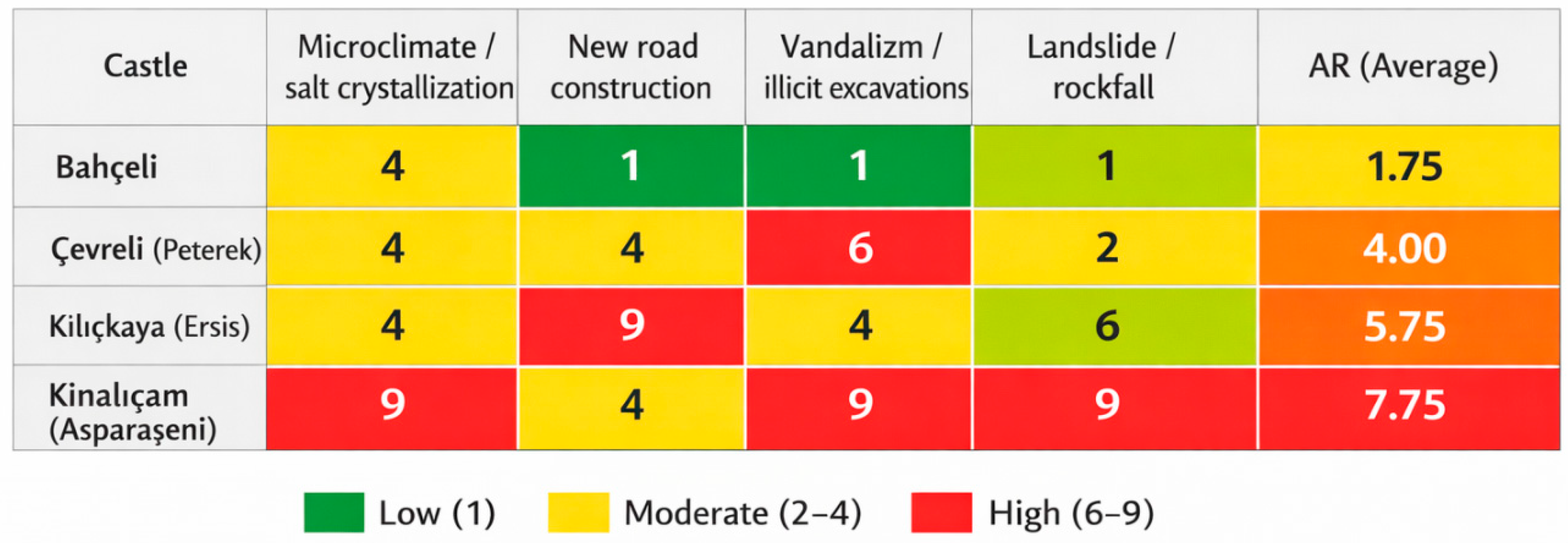
Figure 8.
Sample pages from the material analysis report of a mortar specimen taken from Bahçeli Castle: (a) macroscopic appearance and textural description of the mortar sample within the scope of sampling and visual assessment; (b) chemical/ionic analysis table of the same sample with a brief interpretive note addressing binder–aggregate relationships, porosity, and indicators of contamination and salt-related processes.
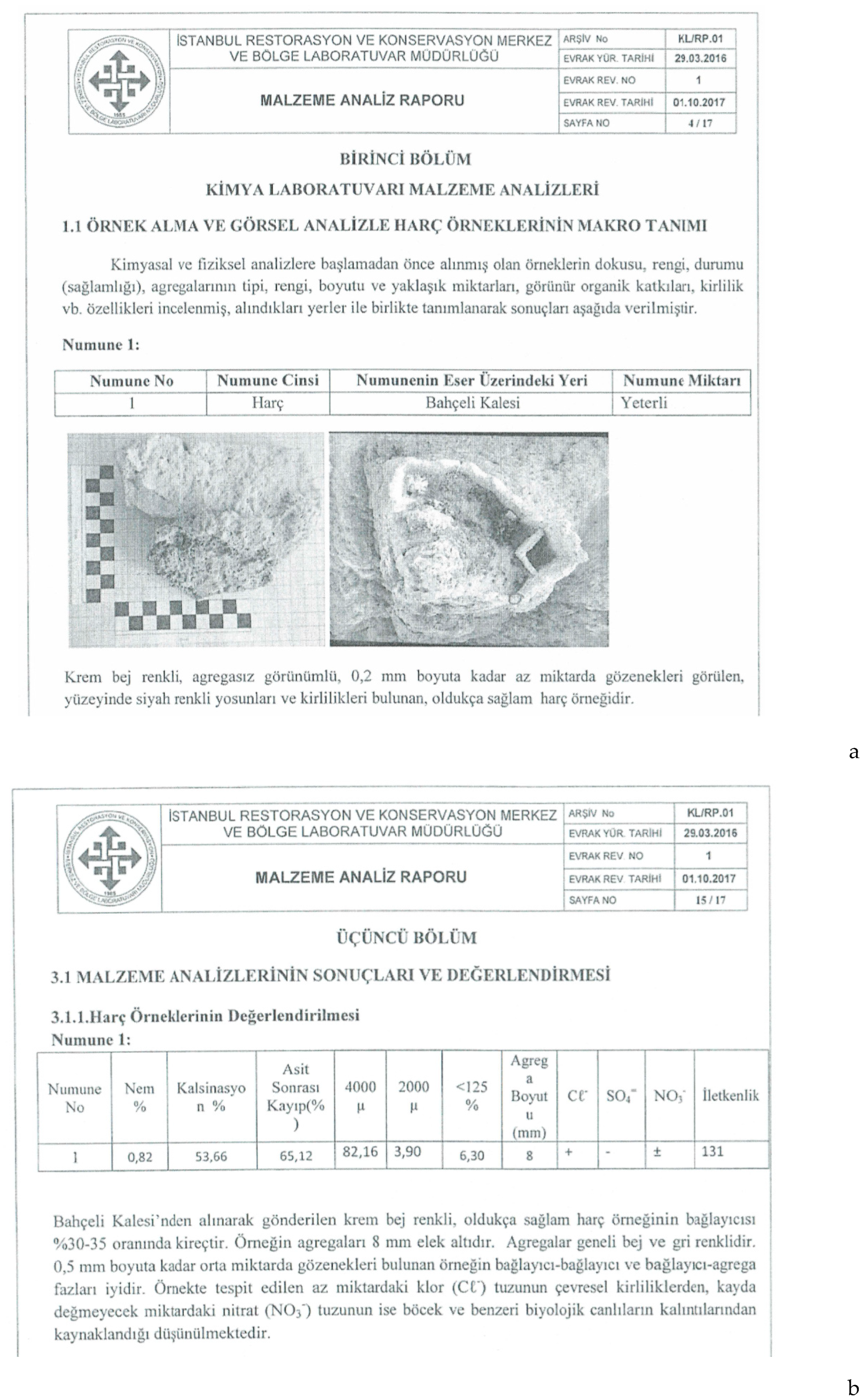
Table 2.
Indicators, Scales, and Data Sources Used in the Modular Prioritization Framework.
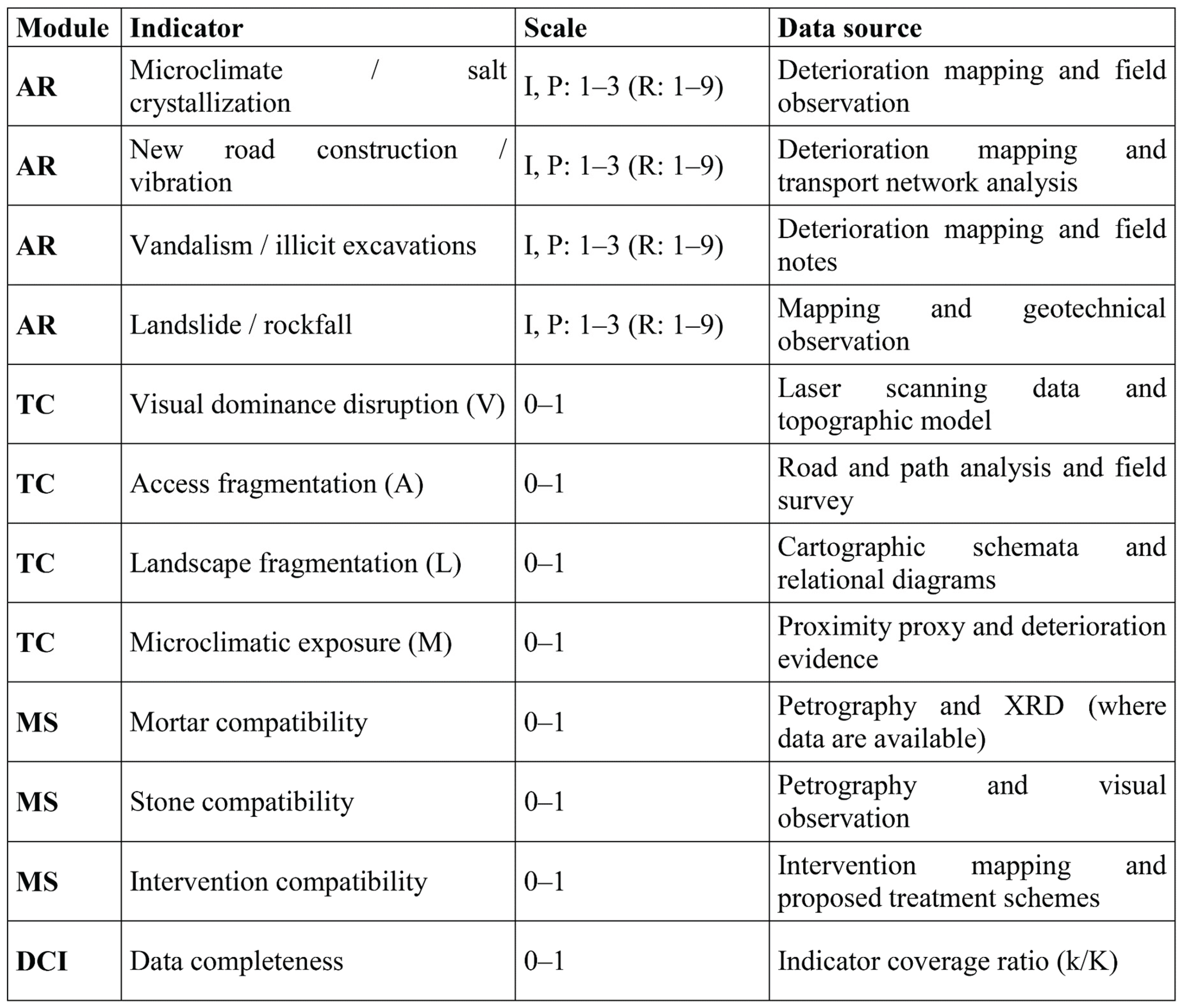
Table 5.
Site-based summary of dominant deterioration types, availability of material analysis, critical findings, and MS interpretation (including NA cases).
Table 5.
Site-based summary of dominant deterioration types, availability of material analysis, critical findings, and MS interpretation (including NA cases).
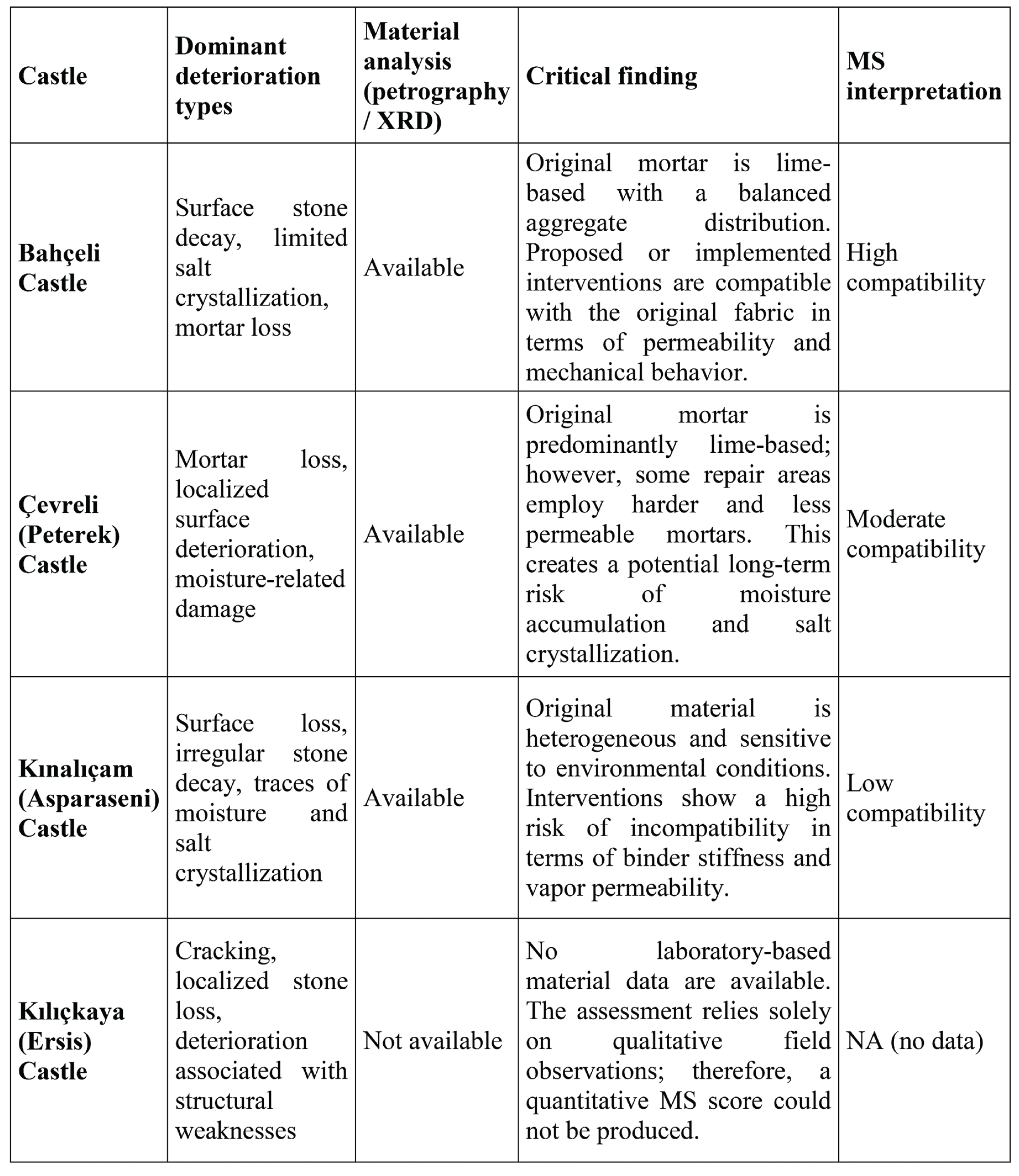
Disclaimer/Publisher’s Note: The statements, opinions and data contained in all publications are solely those of the individual author(s) and contributor(s) and not of MDPI and/or the editor(s). MDPI and/or the editor(s) disclaim responsibility for any injury to people or property resulting from any ideas, methods, instructions or products referred to in the content. |
© 2026 by the authors. Licensee MDPI, Basel, Switzerland. This article is an open access article distributed under the terms and conditions of the Creative Commons Attribution (CC BY) license (http://creativecommons.org/licenses/by/4.0/).
Copyright: This open access article is published under a Creative Commons CC BY 4.0 license, which permit the free download, distribution, and reuse, provided that the author and preprint are cited in any reuse.


