Submitted:
31 December 2025
Posted:
31 December 2025
You are already at the latest version
Abstract
In recent years, numerous studies have been carried out on the landscape of the 5th-15th centuries in Catalonia. When studying settlement, we will assess research on the morphogenesis of villages and highlight differences across regions. We will also see the characteristics of the hamlets of the Early Middle Ages and those of the Pyrenean lands. Farmsteads, which were made up of a house and some land that depended on it, were a fundamental element of the landscape of many regions of Catalonia. To understand the characteristics of the agricultural areas, we will be interested in the concentric shapes or coaxial strips. Furthermore, to understand the landscape of the regions of Lleida and Tortosa, we must understand the transformations that occurred in the Islamic era and the diffusion of ditches and irrigated spaces. Likewise, we will examine the relationship we discover between the coombs and the first medieval settlements and necropolises. It is also important to determine when and why the terraces were built. This study will address the evolution of the landscape throughout Catalonia, with special emphasis on the most recent contributions relating to the regions of Barcelona and Lleida.
Keywords:
landscape
; Middle Ages
; Catalonia
; hamlets
; farmsteads
; fields
; terraces
; irrigation
1. Introduction
The landscape around us has slowly formed over the course of centuries. When I began researching the Middle Ages, I assumed that only a few scattered details could be known about the medieval landscape, which was very limited in both space and time. Soon, however, I began to draw maps of the various counties during the Carolingian period [1]. This made me realize that, thanks to the large number of documents preserved from the ninth and tenth centuries, it was possible to ascertain many aspects of inhabited places and their surroundings before the year 1000. At the same time, reading numerous published studies —particularly from England and France— made me aware of the possibility of reconstructing long-term landscape evolution [2,3].
2. Methodology
When studying landscape history, it is essential to keep the long durée in mind. Although I am a medievalist, I am convinced that, to understand the landscape of the Early Middle Ages, it is necessary to know what existed in the Roman period and, if possible, even what preceded it [4] (pp. 657-688). Moreover, it is equally important to examine how the landscape evolved in the centuries after the fifteenth century, when the period commonly referred to as the Middle Ages came to an end. The work I have carried out over the past few decades has led me to develop a methodology for approaching the medieval landscape. Two central pillars of this research have been the study of written documentation and direct knowledge of the territory. To understand the territory, one must, of course, walk across it; yet sometimes it is even more important to know how to interpret what we observe on twentieth-century maps and aerial photographs [5]. At the same time, it is necessary to make use of as many complementary sources as possible, such as archaeology, toponymy, pollen analysis, GIS-based approaches, radiocarbon dating, and studies using luminescence dating. Indeed, in this article, I wish to demonstrate the importance of drawing on the widest possible range of sources to understand the various components that constituted the medieval landscape.
In recent years, numerous studies have examined the history of the landscape in Catalonia. Cartographic works have been produced, such as the ten volumes of the Atles dels Comtats de la Catalunya Carolíngia [1]. A project known as PaHisCat was launched, similar to the English HLC project. Cartographic studies on the history of the landscape of certain villages, such as Menàrguens or Almacelles, have also been conducted [6]. In addition, numerous articles and books have been published that address both the different Catalan regions and a wide range of thematic issues. Likewise, archaeological excavations have been undertaken that have greatly deepened our knowledge of early medieval villages, of Islamic sites in the regions of Lleida and Tortosa, and of cellera or sagrera settlements in Roussillon [7]. It is also highly significant that a large number of volumes have been published transcribing the entirety of the Carolingian documentation from the eighth to the tenth centuries, as well as a substantial body of texts written between the eleventh and thirteenth centuries, especially by the Fundació Noguera. Furthermore, research has been carried out using GIS, LiDAR, radiocarbon (¹⁴C) dating, and luminescence dating techniques. In the following pages, we will refer to some of these contributions.
In the pages that follow, my aim is to present an overview of the transformations that occurred in Catalonia’s landscape during the Middle Ages, especially considering recent research [4,5,6,7,8]. I wish to show that by combining multiple types of evidence, it is possible to understand how an extensive and diverse territory was organized, how settlements were constructed, and what agricultural lands enabled people to sustain themselves. In fact, it is crucial to determine how agricultural spaces inherited from the Roman period were exploited and how new ones were created. I shall highlight recent contributions and insist on the need to revise certain notions which —though innovative at the time when they were proposed— have now been shown not to correspond exactly to what took place in the different regions. It should also be noted that, when I speak of Catalonia, I refer to the territory defined by its medieval borders [9] (Figure 1).
Accordingly, I shall begin by focusing on settlement, emphasizing the most recent findings. To understand how territory was organized, it is essential to know where people lived. We must be able to identify nucleated settlements (pobles, villages), semi-dispersed settlements (vilars, hamlets), and dispersed farmsteads (masos). On the other hand, between the eighth and the twelfth centuries, Catalonia was a frontier land, with several repercussions that I shall discuss later. I intend, however, to devote most sections to identifying and understanding how the agricultural landscape endured and changed from the sixth to the fifteenth centuries: how cultivated fields were maintained and newly established, how and when irrigated zones were organized, and how new types of spaces largely emerged: the comes (coombs in English) and the feixes or agricultural terraces. Finally, I shall attempt to summarize the results of pollen analyses, which have partly revised what we once believed about the earliest medieval centuries, long considered ‘dark’.
3. Materials
3.1. The Medieval Village and the Organization of Its Surroundings
Studying settlement patterns is fundamental to understanding what the landscape was like in the past. Before examining the issue in detail, several points must be clarified. First, as I have noted above, one must consider the long durée. A few decades ago, it was commonly asserted that medieval villages only emerged after the year 1000. Although it is true that human settlements stabilised after that date, we should not overlook earlier forms of habitation in the preceding centuries, the remains of which are likely to lie beneath many of the modern villages. A further point to consider is that, to understand a village, we must refer both to the settlement nucleus and to its surrounding space, the area from which the inhabitants of the houses obtained the resources necessary for their livelihood. This area had boundaries that we must attempt to identify and comprehend. When doing so, we discover that these boundaries were often stubbornly preserved over the course of centuries. A noteworthy claim has been made: Early medieval hamlets (vilars) may have lacked stability, yet very frequently the territorial unit within which they ‘moved’ corresponded to one that had already existed in Roman times [10]. I must acknowledge that recent contributions from the field of archaeology have greatly transformed our understanding of settlement and landscape during these earliest medieval centuries.
I shall begin by focusing on the villages that became consolidated after the year 1000 and that, often without undergoing substantial change, remained intact up to the twentieth century; although, in recent decades, transformations have often been significant. Broadly speaking, based on the available research and of morphogenetic theories, four large categories of villages may be distinguished: clustered groups of houses very often without walls [3,11,12]; ecclesiastical or sagrera settlements [3,13]; castle-based villages; and planned new towns [3]. Certainly, there also existed linear or street villages, settlements created beside a thermal spring, or those developed around a market square [3]. Bearing this typology in mind, it is worthwhile to study settlement distribution across different territories and to assess and explain their differences. As will be seen, what emerges is important, for it reveals diverse political and social realities. I shall illustrate this with four examples: one located in the territory of the former county of Barcelona, another in Empordà, a third in Ripollès, and, finally, one in Cerdanya (Figure 1).
In recent years, various studies have examined the landscape and settlement in the former county of Barcelona [4,5,14,15]. I shall not offer a detailed description here; rather, I wish to comment briefly on what we observe in the central zone of this county, on both sides of the river Llobregat (Figure 2). In 801, this river became the frontier between the lands conquered for the Carolingian Empire by Charlemagne’s son and those subject to the Emirate of Córdoba. This frontier had an impact on the landscape, as reflected in the characteristic features of the medieval —and even modern— villages in these places. East of the river, a significant proportion of High Medieval villages emerged around a church, within the thirty-pace area protected by the Church (sagrera), whereas west of the Llobregat, many villages developed alongside a castle or fortified tower. In addition, across the entire region, we also find settlements established near a monastery or priory, along a road, or beside a marketplace. Although one must bear in mind that villages founded around a sagrera were created after the year 1000, because of the Peace and Truce of God assemblies, this does not mean that there was no church on the same site beforehand (as has been demonstrated by archaeological research in several locations in the Vallès, for instance at Sentmenat) [16]. It should also be stressed that not every village situated on high ground should be explained as the product of incastellamento imposed coercively by a lord after the year 1000; many castle-based villages are older and must be understood as part of a broader process of settlement that moves up a mountain [17,18].
If we turn to Empordà, within the former county of Empúries, a somewhat different reality emerges [19,20] (Figure 3). We observe that many villages of the High Middle Ages were founded within a 30-foot perimeter around a church. A majority of these are sagrera settlements. Nevertheless, the profound feudalisation of society after the year 1000 led to the construction of castles and fortified houses throughout the region. Many castles were erected very close to the churches and often virtually within the sacral thirty-pace boundary. In certain cases, there was even a relocation of population from the area around the church to the vicinity of the castle, as can be seen at Foixà or Torroella de Fluvià. In these instances, it is indeed appropriate to speak of a process of incastellamento.
Ripollès is a Pre-Pyrenean district (comarca) (Figure 4). In its southern sector, we find a predominance of dispersed settlement, like that further south, in the district of Osona or the Vic plain [21]. However, in most cases, we do not find evidence of a sagrera where the population would once have gathered around the local church. Most families lived scattered on their farmsteads. In contrast, in the northern part of Ripollès, nearly all the villages are open, meaning that the houses themselves structure the village space. These dwellings are often separated from one another. All these open settlements, composed of houses not attached, lie at altitudes of around 1000 metres or higher. It is easy to conclude that, in the majority of cases, once the village already existed, a church was subsequently built at a distance from the inhabited core. For example, the church of Sant Cristòfol de Toses, located at 1470 metres, stands to the northeast of the village, above it, slightly removed from the residential area.
The region (comarca) of Cerdanya, in the Pyrenees, consists of a high plateau, almost entirely above 1,000 metres, surrounded by mountains and traversed by the river Segre [23,24]. I shall focus on the western part of the district, around the town of Bellver (Figure 5). As the map shows, the vast majority of villages, often not very large, are open settlements, in which the houses themselves determine the shape of the inhabited nucleus. In some of these villages, located above 1,000 metres, there is no church; however, in most cases, the church is detached from the residential centre and quite often built at a higher point, above the houses. As noted earlier regarding Ripollès, the church must have been constructed at a later stage. There are a few cases in which either a church or a castle had a decisive impact on the formation of the late-medieval village. We cannot forget, however, that Bellver was a new planned settlement established in 1225.
As noted above, studying villages means examining how houses, churches, castles, squares, and streets were organised, but it also entails uncovering the nature of the territory on which they depended. This includes understanding the boundaries that enclose their fields, orchards or gardens, pastures, and woodlands. One fact, which may at first appear surprising, must be emphasised: as already mentioned, in some cases these boundaries were older than the village at their centre, despite the latter appearing to be the reason for the existence of the territorial unit. In simplified terms, we may speak of boundaries that coincide with geographical features and of others that follow roads or correspond to pre-medieval orientations. I shall comment briefly on some examples of the latter, though I will not elaborate at length, since these cases are well known. First, mention should be made of Vila-sacra (Alt Empordà), where three of its boundaries (east, south, and west) align precisely with orientations belonging to a pre-medieval centuriation system [3] (p. 300). Although the name of the place leads us to think of a villa Alisacari, the estate of an individual bearing a Frankish name [25], it must be assumed that this 6.2 km² territory, delimited in this way, already existed prior to the Carolingian period —when it is first documented— and very probably before the Visigothic centuries as well.
A second example comes from Baix Empordà. In a will of 989 [26] (p. 463), reference is made to the donation of an estate extending across the terms of Ultramort (villa Vultur Murt), Parlavà (Palacio Ravano), and the villa of Rupià (villa Rupiano). When these territorial units are plotted on a map, we see that each corresponds to an area of approximately 3.5 km²; we also note that the territory of Rupià expanded towards the south, reaching Puig Rodó, and that of Ultramort extended northwards to the river Ter (in both cases by little more than 1 km²). Here too, the documents and toponyms reveal places of considerable antiquity. A document dated around the year 800 already refers to the church of Santa Eulàlia (Sancte Eulalie de Vulture Mortuo) [26] (Figure 6). It is likewise important to stress that Rupià is a Roman toponym, and that the name Parlavà derives from a palatium, almost certainly of fiscal origin, and from Hraban, probably a Frankish Germanic name belonging to the individual who settled there at the end of the eighth century [25]. In short, for our purposes, what matters is that these places and their respective territorial units —whose limits largely coincide with Roman centuriation alignments— very likely existed from the beginning of the medieval period.
Let us turn now to the west of the river Llobregat. The territory of Gelida (Alt Penedès) extends along both sides of the river Anoia. As in the previous examples, the limits on the north-eastern and south-western sides of this territory coincide precisely with a Roman land division, while the south-eastern boundary runs along the mountain ridge. If we isolate the area defined by these ancient delimiting lines, we obtain a rectangle of approximately 13.5 km². What is particularly striking is that the place bears the name of a Berber tribe. At the time of the Islamic conquest, around 713, a group of Amazigh people must have been granted control of this territory, from which a highly strategic point —on the old Via Augusta— could be supervised. They do not appear to have modified the existing boundaries, perhaps because much of the population that had lived there previously remained in place and preserved its memory. At times, territorial organisation and toponymy enable us to formulate hypotheses regarding how people lived and organised their space in the past.
Obviously, it is essential to understand how and when the territories associated with different inhabited sites were formed. Leaving aside the possible pre-medieval precedents already mentioned, the existence of an economic unit must first be recognised, for example, in relation to the territory belonging to the community associated with a hamlet (or a vilar). In some instances, this territory expanded and was transformed into the territorial unit of a Carolingian villa, a parish, a castle district, and, in the modern period, a municipality or commune. It should be borne in mind that the combination of several economic units often created a larger territorial whole, such as that of a parish. This is clearly reflected in numerous acts of consecration and endowment of parishes in the ninth and tenth centuries, such as those concerning Aiguafreda (898), L’Ametlla del Vallès (932), or la Roca del Vallès (932) [27]. In the case of L’Ametlla, the area from which tithes were levied included eleven hamlets or inhabited establishments, some of considerable antiquity, such as Palau (now a mas) [4] (pp. 561-561). This territory of L’Ametlla corresponds to the present-day municipality situated in the comarca of Vallès Oriental.
3.2. The Hamlet: Early Medieval Form of Settlement
In Catalan, there exists a word, fossilised today as a place name, which perfectly describes settlement sites of the early medieval centuries. This word is vilar, corresponding to English hamlet, French hameau, and German Weiler. The term vilar appears frequently in medieval documentation, especially in texts from the Carolingian period. It referred to a location containing a small cluster of houses —generally fewer than ten— where there was usually neither a church nor a castle. The dwellings tended to be situated close together. It is important to realise that grasping the significance of this settlement type is key to understanding the habitat of the Early Middle Ages. Archaeologists who have excavated examples, for instance in the regions of Vallès or Rosselló (French: Roussillon), note that these settlements were typically not very stable: every few decades they might be relocated, sometimes only a few hundred metres away [28].
We shall approach the vilars or hamlets from three perspectives. First, by examining written documentation, which, as I have noted, is particularly abundant in Catalonia during the Carolingian centuries. Second, there is evidence from recent excavations. And third, by consulting current maps and orthophotography surveys. In a certain sense, hamlets may be considered heirs to Roman villae, which were abandoned and collapsed. We know that the peasants and slaves likely remained on the land, whereas the landowners settled in castella or in towns. The majority of hamlets were almost certainly founded during the Early Middle Ages.
There exists an exceptional document dating to 913, associated with the female Benedictine monastery of Sant Joan de les Abadesses [21,29]. The territory of Sant Joan was quite extensive —around 62 km²— and stretched along both banks of the river Ter, in the region of Ripollès (Figure 7). What is most remarkable in this case is that we can determine how many hamlets existed, what names these settlements bore, and even how many families lived in each of them. In addition, we know the names of every man and woman residing there, a particularly valuable aspect if we wish to study the linguistic origins of personal names and thereby learn more about these people [29,30]. What matters here, however, is that within an area of approximately 62 km², much of it mountainous, there were twenty-one hamlets (sometimes considered villae). They varied in size. In the vilar of Forns (Fornos), there were six families; in that of Vedellar, many more, thirteen. In the vilar of Muig, five families are mentioned, although perhaps not all of them lived within the same settlement cluster, suggesting that at times there may already have existed a degree of dispersed settlement, even prior to the eleventh century. This document has given rise to numerous studies [30].
It may be stated that, all too often, there is insufficient communication between historians who rely solely on written sources and historians who are archaeologists. Having pursued both approaches to understanding the past, I am aware of this gap, and of a certain sense of superiority occasionally felt by both sides. Be that as it may, it should be acknowledged that the contributions of archaeologists in recent years to the origins of medieval settlement have been fundamental, and it is important that they be reflected in historical syntheses. Let us turn now to two territories where particularly notable research has been carried out.
In the region of Vallès (north of Barcelona), Jordi Roig notes that some early villages were located on the site of former Roman villae (61%), whereas others were established away from earlier structures (39%) [31,32]. The dwellings of these settlements from the sixth to eighth centuries were modest: generally, only sunken-featured buildings covered with wood and branches. These hamlets were originally inhabited by four or five families, and in some cases perhaps slightly more. In addition to the houses, numerous storage silos for cereals were usually present, as were, at times, a necropolis. Wine presses, olive mills, and bread ovens might also have existed. Many of these excavated settlements were situated near watercourses and were not far from one another; distances ranged from 0.5 km to 1.5 km. Since we certainly do not know all the settlements that once existed, it is reasonable to assume that in this plain of Vallès, in this ‘dark’ period, a substantial population may have lived there. It is impossible to compare the population density of the sixth to eighth centuries with that of the Roman period, yet it is clear that the region was by no means deserted.
Because of rescue excavations in Roussillon during the construction of the LGV (Ligne à Grande Vitesse), evidence of four Visigothic-period settlements was discovered along a relatively short stretch. In these cases, no connection with earlier Roman structures could be established [28]. These settlements also featured storage silos and, in more marginal zones, pottery kilns. Their constructions were built on stone foundations and had tàpia (rammed earth) walls. As noted above, throughout the sixth to eighth centuries, changes in location were frequent in this plain of Roussillon; these settlements were distributed across a relatively limited territory. As previously suggested, these movements likely occurred within the boundaries of a territory that may have corresponded to that of a former Roman villa. In fact, this should lead us to think about the weight the lords still held and the importance of the boundaries of large manorial estates.
I have not wished to create a separate section entitled ‘What the dead can tell us.’ However, I believe that understanding the location of early medieval burials is extremely important for two reasons. First, because it allows us to affirm that in certain areas, population density was relatively high in the sixth to eighth centuries. Second, because at times it seems that graves hewn into the rock or built of stone slabs marked reference points within the territory controlled by each community, or even indicated the boundary of the land, depending upon the inhabitants of a particular hamlet.
In the Baix Berguedà (the southern sector of the region), a significant number of rock-cut tombs have been identified. Owing to their location and their structural characteristics, these burials can be securely dated to the fifth to eighth centuries. They were carved into prominent rocky outcrops, sometimes in the middle of a field, sometimes on a slope, and occasionally on the edge of a cliff. Within an area of about 155 km², eighteen tombs or groups of tombs of this type have been documented [33]. This number is considerable, but almost certainly incomplete. In any case, it may be inferred that each settlement associated with these rock-cut burials might have controlled an area of approximately 8.6 km². Only in very few cases do we know exactly where the individuals buried at these sites lived, though it is evident that they could not have resided far from them, as has been demonstrated in some instances.
As mentioned earlier, in more than one location, these tombs have been observed to lie at or near the limits of the territory belonging to a settlement. A particularly striking example may be seen between Montcortès and L’Aranyó, in the region of Segarra, where a rocky outcrop had been used, in Roman times, to cut eight lateral niches functioning as a columbarium. Later, at the beginning of the Middle Ages, five tombs with rounded ends were hollowed out on their upper surface. The most notable aspect is that this small necropolis lies precisely on the boundary between the two villages, close to where, plausibly, there were already distinct human settlements in the early medieval period.
Finally, we may approach the hamlets through the study of present-day orthophotos. We shall consider several locations in the district of Vallès: Bosquerons, Bogunyà, Plandolit, and Salallacera. These four places are well documented, and when we examine current aerial imagery, we detect features that reveal earlier patterns or show how cultivated lands were gradually organised.
Bosquerons, in the municipality of Montornès del Vallès, is an exceptional example (Figure 8). In a document dated 989 [34] (p. 912), a strip of land (fexa I de terra) with a pear tree was sold; this land lay in an area recorded as Bascherones. The boundary clauses merit attention: to the east was a woodland (ipso boscho), to the west the river Besòs, and to the north and south two strips of land, presumably similar elongated plots. This site interests us because of the shape of the holdings —parallel strips— but also because of the configuration of this cultivated and inhabited space, which we may regard as a hamlet (with several families) that subsequently became a single farmstead (mas) [5] (pp. 361-367). Its morphology recalls, to some extent, what Ausonius described in the fourth century when evoking his small estate [35] (pp. 215-220): a river, fields, a path beside the dwellings, and, behind them, further uphill, some wood.
Another comparable site is Bogunyà, in the municipality of Terrassa. Although, like most of the places discussed here, it has been considerably transformed over recent decades, we can nonetheless reconstruct its former appearance by consulting mid-twentieth-century aerial photographs. In 1015, the locum vocitatum in Buguniano was mentioned [5] (pp. 403-408). This, therefore, is a place bearing a name formed in the Roman period, where tombs constructed with tegulae —presumably dating from the transitional phase between Late Antiquity and the Early Middle Ages— have been found. In the medieval period, a hamlet was probably established some 400 m north of this necropolis. In front of it, extending as far as the Riera de Palau, there were, in the last century, 3 hectares of market-garden land (horts). We can also observe braided terraces and, somewhat farther away, to the west and the east, beyond the stream, lie extensive cultivated fields. Further north, in the valley traversed by the torrent of Can Bogunyà, there would once have been oak woodland, attested in medieval documentation. Despite the uncertainties, the site suggests the existence of a possible Roman estate which, in the medieval period, became the territory of a hamlet. This, however, remains a hypothesis.
Plandolit, in the municipality of L’Ametlla del Vallès, is already mentioned in 932 [4] (pp. 172-175). This site was inhabited in the Carolingian period, and likely also earlier, during the Andalusi period. It lies very close to the boundary separating flat agricultural land from wooded terrain (indeed, the area is still known as the forest of Can Plandolit); in fact, the Can Reixac stream, which flows 50 m east of the farmhouse, marks the division between the two. In this case, moreover, the layout of the pathways and the cultivated fields follows pre-medieval patterns of land partition. We may assume that at least 80 hectares belonged to lands dependent upon the vilar of Plandolit. Approximately, Plandolit today comprises 50 hectares of cultivated land and, to the east, roughly 30 hectares of woodland. Although we cannot know precisely what this landscape was like a thousand years ago, we can be confident that many of its structural components —certain paths, property boundaries, and an area partly agricultural and partly wooded— were already in existence, perhaps in a form not too dissimilar from that visible in mid-twentieth-century aerial photography.
While the previous three cases suggest hamlets established at the location of earlier estates, Salallacera almost certainly brings us closer to a hamlet created during the Early Middle Ages (Figure 9). In 961, land, partly cultivated and partly uncultivated, located in the district of Llacera (Sant Llorenç Savall), at a place known as Sales, was sold [4] (pp. 153-156) [29] (p. 445). At this site, there were cultivated plots, vineyards, and fruit trees. In modern times, this putative hamlet became a single farmhouse (mas), comprising 5.5 hectares of arable land, largely arranged as terraces or stepped fields, spread across a ground with an elevation difference of over 70 m. Determining exactly when these terraces were constructed is difficult. In the tenth century, the present terraces may have been (i) simply sloping land without any stone or earthen retaining walls; (ii) ground with small embankments and terraced plots on a steep incline; or (iii) terrain already closely resembling what may be observed in mid-twentieth-century aerial images. Based on the excavations carried out to date, we may tentatively favour one of the latter two possibilities. Moreover, the lands associated with this ‘Sala’ within the district of Llacera plausibly extended over about 140 hectares, mostly consisting of woodland.
This section has approached the study of hamlets from several angles. The combination of information derived from different sources is, we believe, essential. Some hamlets ultimately became villages; others are now single farmsteads; and others still survive as hamlets (despite the major transformations of recent decades). Numerous examples may be found by examining the settlement pattern of the parishes of Andorra [36] (p. 35). Within the parish of Sant Julià de Lòria, the southernmost of them, there still exist the hamlets of Juberri, Auvinyà, Aixirivall, Nagol, Certers, Llumeneres, Fontaneda, Bixessarri, Aixàs, Aixovall, Pui d’Olivesa, and Tolse. Furthermore, if we wish to deepen our understanding of the origins of these sites, the contribution of toponymic research must be considered: Auvinyà is a Roman name, Juberri and Bixessarri are Basque in origin, and Llumeneres (meaning ‘boundary’) is Romance in origin [25].
3.3. The Farmstead: A House with Agricultural and Forest Land
To understand how the landscape across a significant part of Catalonia was organised, it is essential to study farmsteads (masos). This topic has interested me for many years. I excavated a mas built in the tenth century and abandoned in the fourteenth century [37], and I also produced a monograph on the distribution of farmsteads in the High Middle Ages within a parish of the comarca or district of La Garrotxa [38]. In municipalities where farmsteads predominated, settlement was dispersed. In the Girona region, in parishes such as Riudellots, Sant Cebrià dels Alls, Llambilles, or Montnegre, less than a quarter of the population lived in concentrated areas [39] (p. 154). It must be noted that farmsteads are found on flat land, as in Osona, but we must also bear in mind that their creation enabled the occupation of large areas that had previously been forested; we shall examine some examples below. It is worth stressing that farmsteads were not built on very high ground and were not important in the New Catalonia (where, at most, they were constructed in spaces interspersed between territories belonging to nucleated villages). In this section, we shall approach farmsteads from various perspectives: first, on the basis of written documentation; second, through the results of archaeological excavations carried out in recent years; and third, through what is visible in today’s landscape.
Some years ago, I studied how the parish of El Sallent, in the municipality of Santa Pau (La Garrotxa), developed [38]. In this parish, prior to the year 1000, there were likely eight or nine hamlets. During the eleventh century, some twenty-seven farmsteads were established. In the twelfth century, two bordes (half-farmsteads) were added. Around the year 1300, a further six masoveries were created, associated simultaneously with the holders of the farmsteads and with the lordship, in this case, the monastery of Banyoles. Each farmstead lay several hundred metres from the nearest one. Around the parish church, there were very few dwellings. We would find comparable spatial organization in neighbouring regions of Old Catalonia [40,41]. It should be noted that written sources also allow us to understand what kind of dwelling stood at the centre of a farmstead (mas), especially for the later medieval centuries. Such documentation is valuable, for example, for identifying the emergence of peasant houses with an upper floor, which became more common in the fourteenth and fifteenth centuries [42].
Archaeology has greatly enhanced our knowledge of what the earliest farmsteads, built around the year 1000, were actually like. In recent years, archaeological excavations have been undertaken at several farmsteads: Vilosiu [37], La Creu de Pedra [43], and Sa Palomera [44]. Frequently, these buildings were constructed against an outcrop of rock and consisted of two or three rooms, with stone walls and roofs of branches or stone slabs. They contained a hearth and, often, an oven. Beside the house stood livestock enclosures. Soon thereafter, farmsteads grew larger, with more rooms, and, as already noted, came to include an upper floor. The better-off peasants built tower-farmsteads, which were the precursors of the masies of the later Middle Ages and of the Modern period.
I wish to highlight what aerial photographs reveal. In the Vallès Oriental, there are places that deserve close attention because they reveal much about the formation of dispersed settlement. The area comprising Can Borra (can means the house of), Cal Xiquet, Can Pere Piler, and Can Casavella, around the mid-twentieth century, was full of fields, terraces, and above all, woodland; this remains largely true today (Figure 10). Unlike many other parts of this region of the Vallès, this area has been only slightly modified. A close examination reveals a striking reality. To the west of this zone, the fields and the boundaries of wooded areas predominantly follow alignments that coincide with Roman-period land divisions [4] (pp. 210-215). In this sector, we find the farmsteads Casavella and Can Pere Piler and, on the western edge, the farmhouse of Can Marquès, where significant Roman remains came to light. By contrast, in the eastern sector, the concentric field layouts observable there, together with the numerous terraced fields (braided or parallel-sided terraces) surrounding the locations of other farmsteads, are of great interest.
We are fully aware that we need to ascertain when all these farmsteads were constructed, as they profoundly altered this space while also making extensive use of features that had been present for many centuries. In principle, these farmsteads date from the High Middle Ages (c. 1000-1348), although it is very likely that earlier antecedents, already present in the Carolingian period, could be identified. In short, if we focus on two farmsteads, we observe that Can Borra is surrounded by fields laid out in concentric forms, whereas Casavella has fields laid out in quadrangular forms. The two are separated by only 270 metres. Around the farmstead of Can Borra, built on the western flank of the hill of that name, the cultivated landforms an initial ring enclosing an area of approximately 9.6 hectares. A second ring defines land extending across a further c. 11.2 hectares. Can Borra may be an eleventh-century mas, although it is very possible that an earlier hamlet existed on this site and subsequently fragmented into multiple farmsteads.
Let us consider another example located nearby, in the municipality of La Roca del Vallès (Figure 11). In 1156, reference is made to a farmstead situated at the place called Bellsolell (present-day Can Solei; a solell denotes a south-facing slope). In 1211, a capbreu lists 30 farmsteads, one of which was Guillem de Bellsolell’s farmstead [4] (pp. 204-208). A capbreu was a document where the confessions or acknowledgements of the peasants before the lords were recorded, to preserve proof of the existence of the lord’s rights. The same capbreu also refers to the farmstead of Joan Gener, now Can Gener. The farmstead of Can Solei lies on slightly elevated ground, surrounded by fields oriented primarily according to a pre-medieval layout. At 265 m to the west of the farmstead runs the Valldoriolf stream. Despite possible differences, this territorial organisation resembles, for example, that found at Bosquerons or Bogunyà: an inhabited site facing a watercourse, bordered by strips of cultivated land, and with forested land behind. It is almost certain that a hamlet existed in the Early Middle Ages at the site of Can Solei or Can Gener.
It is precisely in this wooded area extending eastwards behind the present-day farmstead that three additional farmsteads —Can Masferrer, Can Ribes, and Can Font— were built, possibly in the eleventh century. All three were established beside small depressions that resemble shallow coombs. This circumstance led the cultivated land around them to take on more rounded, less linear shapes. Another point of interest is that each of these farmsteads comprises both cultivated land and woodland. In sum, as in the previous case, we can contrast a landscape that has pre-1000 antecedents with another landscape that was almost certainly organised after that date.
3.4. The Settlements on the Other Side of the Border
In the study of medieval Catalonia, it is standard practice to distinguish between ‘Old Catalonia’ (Catalunya Vella) and ‘New Catalonia’ (Catalunya Nova) [45]. The territory considered ‘old’ corresponds, broadly speaking, to Carolingian Catalonia, which in the eighth and ninth centuries was divided into several counties. ‘New’ Catalonia consisted of regions that, between the ninth and twelfth centuries, remained under Islamic rule. Their principal centres were the cities of Lleida and Tortosa. The landscape of these western and southern regions differs somewhat, first because they are more arid. It must be recalled that between the area controlled by the Catalan counts and the territories under Islamic power lay a frontier zone. Written documents refer to a broad frontier belt —the marches or borderlands of the various counties— where a greater concentration of castles was found, and where territory and, often, settlement itself were organized around these fortifications.
It must be acknowledged that we still know relatively little about settlement patterns, for example, in Lleida, during the Islamic period. In many instances, what we know derives from later documentation produced after the conquest carried out by the counts of Barcelona and Urgell. The textual evidence indicates that around the city of Lleida, there were almúnies and tower residences. To date, only a few fortified habitation sites, the so-called towers (Arabic abrag, plural of burg) and several castles have been excavated. The most substantial excavations concerning this period have taken place within urban contexts, notably at Balaguer, Lleida, and Tortosa [46,47].
In what follows, to understand the evolution of the landscape, I shall outline the changes and continuities between the eighth and twelfth centuries, which will enable us to grasp the configuration of these lands under Islamic rule. We shall consider specific case studies. First, we shall focus on Matxerri (Les Garrigues), a case that highlights the importance of assessing continuity (Figure 12). It must be borne in mind that, although substantial changes occurred in the Andalusi territories, these developments were gradual and did not entail a complete alteration of the landscape. In fact, a large share of the population living there before 713 —year in which the armies of Arabs and Berbers arrived— continued to inhabit the region afterwards. In approaching Matxerri, we shall make use of orthophotographic imagery. In this case, we shall also draw upon an additional source of information that is sometimes crucial: toponymy. According to Joan Coromines, the name Matxerri derives from the Latin macĕrĭes, probably referring to rammed-earth walls [25]. In fact, in Roman times, there were low walls that limited a space [48] (p. 122). At present, what we see at this site is a long, dry coomb 5.1 km in length (within the municipality’s limits). The name and the area’s physical characteristics point to a landscape very probably created during the Visigothic period and only minimally altered in subsequent phases.
Secondly, we shall draw on archaeological evidence. The burials of the necropolis at Tossal de les Forques (La Noguera) are located along a ridge extending roughly 150 m, where thirty-eight tombs carved into the rock have been identified. According to radiocarbon dating, one of these graves must be placed in the second half of the seventh century, whereas another burial, containing the remains of a woman approximately forty years of age, seems to have been cut in the ninth century. It is therefore plausible that she was a Christian woman living under Islamic rule [49] (pp. 141–145).
Even in these lands of so-called ‘New Catalonia’, we encounter the boundaries of rural territories whose origins appear to reach far back in time. Modern maps reveal areas whose perimeters seem to preserve very ancient limits, dating from the Andalusi period or, conceivably, even earlier. Vensilló is an enclave of the municipality of Els Alamús (Segrià) within the comarca of Pla d’Urgell, covering an area of 7.6 km² (Figure 13). According to Coromines, this toponym derives from the Arabic name Iben Sallûm [25]. It is now irrigated land, but in the Middle Ages it was not. A study of its boundary lines reveals that they coincide with livestock paths, and some even follow pre-medieval orientations. We must assume that the community inhabiting this area devoted itself primarily to pastoral activities, which, as we know, were of considerable significance in these lands of the Lleida region [50].
Archaeological excavations likewise allow us to reconstruct the context immediately preceding the conquest undertaken by the counts of Barcelona and Urgell. In this regard, the excavations conducted at Solibernat (Torres de Segre) and at Safranals (Fraga) have been fundamental. At Solibernat, the remains of a small fortified settlement (burg or tower) were uncovered on the summit of an elongated hill, approximately 55 m long and 12 m wide. On both sides of the upper surface of the hill, there was a perimeter wall, and at each end rose rectangular towers. The site also contained several chambers used as dwellings, a storage area, and a space for livestock. This tower at Solibernat was constructed in the first half of the twelfth century [51]. The site at Safranals, located near the river Cinca, displayed similar characteristics. Nevertheless, no excavation has yet been carried out of an unfortified settlement, neither of an almúnia nor of an alqueria.
We shall return later to hydraulic installations. Before closing this section, however, a clarification is required. Logically, to understand the landscape of New Catalonia, one must consider the crucial role of irrigation channels (séquies). Yet I must state from the outset that I would not dare to affirm that all small hydraulic systems —such as those found near the so-called clamors or reguers— were created after the eighth century, that is, during the centuries of Islamic rule. What can be asserted with certainty is that major canal systems —such as those of Fontanet, Alcarràs, and Segrià— were built in the Islamic period, transforming many hectares of land on both sides of the large rivers, such as the Segre.
It must be borne in mind that the vast majority of the population living in Lleida or Tortosa around the year 1100 consisted of descendants of families who had already settled there prior to the Islamic conquest of 713. We also know that the process of Islamisation was gradual, especially in regions situated near the frontier [52,53]. Likewise, we must consider that the population of New Catalonia under Islamic governance cultivated irrigated lands in part —particularly when the cities gained prominence and were able to organise extensive irrigated zones— yet that a substantial portion undoubtedly worked dry-farming land, as numerous written documents clearly attest. These were dry lands of the sort we would have found at Matxerri or those attested on the plains of Selgua, already on the right bank of the Cinca, in an Aragonese-speaking area very close to Monzón, where Catalan was spoken in the medieval period [54] (p. 189). We must also remember that, as we have observed in the case of Vensilló, a significant share of the population must have depended on livestock raising.
3.5. Fields with History and Paths
To study and understand how fields were organized throughout the Middle Ages, it is essential to analyse several components of the landscape that display distinctive characteristics. First, one must assess the weight of the pre-medieval past, particularly the centuriations and the extent to which these early parcelled layouts continued to exert influence in later periods. Second, attention must be paid to the role of communication routes, which very often provide the basic framework for the structure of agricultural land. Third, concentric forms must be considered, as these reflect processes of territorial colonization and reorganization. Fourth, we must identify and attempt to date coaxial strips of arable land. Finally, we must consider the significance of irrigated areas, of valley bottoms or coombs (comes), and of terraces, which we shall examine in subsequent sections.
Understanding the relevance of centuriations in the Middle Ages is crucial for interpreting the characteristics of many communication routes. It is likewise fundamental if we wish to understand the configuration of certain municipal boundaries, as we observed in our discussion of Vila-sacra and Rupià or Ultramort. Indeed, these pre-medieval centuriations and parcel systems exercised substantial influence over the organization of cultivated spaces. Nonetheless, in many cases we cannot determine whether present-day configurations derive directly from transformations of the Roman period, or whether they are the product of indirect influences —for example, those stemming from pre-existing roads— and whether, in fact, individual land plots were laid out according to a specifically medieval plan.
In discussing fields, we wish to comment on a phenomenon observable across several regions and documented in other neighbouring countries. In some areas, aerial views reveal nearly circular, concentric forms inscribed in the landscape [55] (p. 337) [56]. These features indicate two things. First, they point to a process of territorial occupation radiating outward from a central point. Second, they imply that, prior to this land reorganisation, a phase of depopulation or abandonment of previously cultivated areas had occurred. In Catalonia, we can find many cases [57]. We shall examine three examples, located in very different regions, which will in turn give rise to a variety of reflections.
A first example takes us back to the Early Middle Ages. In the Alt Empordà district, in 982, the placename Vilajuïga (Villa Iudaica) is attested, clearly designating a settlement that must already have existed for several centuries (Figure 14). Its church was dedicated to Saint Felix (Sant Feliu). The name of the settlement suggests that a Jewish community resided there at least by 785. This situation resembles that attested, for instance, some 170 km away in the border town of Cubelles, where several Jewish families lived during the tenth century (in 974 we find mention of Iuda, ebreo, que vocant Vivas, filium Iacob, ebreo) [34] (p. 584). We should note that in Vilajuïga several modern roads follow older alignments, very likely corresponding to pre-medieval parcel divisions. Moreover, both the Vilajuïga stream and the Garriguella stream share the same orientation as centuriation Emporiae III. What concerns us most at present, however, is that —when observing the boundaries of fields and existing pathways— one finds concentric patterns surrounding the settlement. Particularly to the south-east and north-west, rounded field boundaries appear at approximately 500, 600, and 1000 metres from the centre of the village. Although this remains hypothetical, we may reasonably suppose that the spatial reorganization which generated these lines —now visible from the air— occurred in the early medieval centuries [58]. It is evident that in Vilajuïga, elements from the Roman period, the Early Middle Ages, and the modern era coexist in the present-day landscape.
A second example brings us to around the year 1000. The Baix Penedès was conquered by the count of Barcelona at the end of the tenth century, although in certain parts of that territory control was not consolidated until the eleventh century. This situation almost certainly resulted in a period of depopulation. We must bear in mind that by this date, the population had undergone almost complete Islamisation, and as noted above, this population was largely descended from families already settled there prior to 713. At Banyeres del Penedès, old paths and traces of ancient parcel divisions are still discernible [5] (p. 714) (Figure 15). Furthermore, aerial photographs reveal several concentric lines around the site where the watchtower (and later the castle) was constructed, and where the church stood. The closest of these lies at approximately 600 m; others are visible up to 1,550 m away. These traces attest to a major territorial reorganisation, and this case is by no means unique. At another location, 3.8 km to the southwest, at Santa Oliva, documentary sources state —almost certainly with deliberate rhetoric— that in 1012, owing to Islamic raids, the site was fit only for pasture for onagers, deer, and other animals. This claim was surely exaggerated, yet it nonetheless illustrates the extent of abandonment that occurred over several decades in this region.
A third example is perhaps even more difficult to date. At the western edge of the Aragonese comarca of Baix Cinca, at Candasnos (called Campdàsens in medieval records), we can still observe an agricultural area laid out with a network of radioconcentric routes, together with at least two paths encircling the land surrounding the settlement (Figure 16). Various hypotheses have been proposed regarding the origins of this planned space [59]. One is that it represents an Islamic-period layout. Another, more plausible hypothesis is that it corresponds to a scheme established around 1217, when these lands were granted to thirty-seven families. The existence of these routes allows us to identify several distinct rings. Within the first circle, with a radius of 400 m, lay the village itself, together with animal pens, threshing floors, and several ponds. In the second ring, extending to 1.1 km, were chiefly fodder crops destined for animal feed. In the third ring, with a maximum radius of roughly 2.6 km from the village, were the arable fields, arranged in radioconcentric strips. Beyond this area stretched, to the north, pastureland and, to the south, tracts of land reserved for communal use.
The strips of land constitute another landscape element with specific characteristics, and it is important to locate and study them. This is a complex issue, for which it is difficult to reach firm conclusions, and especially conclusions that can be generalised across different regions. In principle, these strips must also be understood in the context of a planned process of territorial occupation. A very interesting study on this subject has been conducted in the northern part of València, where these strips are related to the process of conquest during the thirteenth century [60]. We can, however, affirm that some examples are considerably older, as we noted when discussing the place of Bosquerons, where a document from the year 989 mentions fexa I de terra, a strip of level ground. Several examples will be discussed below, which I believe illustrate the complexity of this phenomenon. In fact, in Catalonia, we do not find examples of strips that extend over a large territory, but only strips resulting from the distribution of farmland [48].
The slightly inclined slope on the left bank of the river Anoia, between Bedorc to the north and El Freixe to the south, presents a particularly interesting case (Figure 17). The slope is divided by paths or banks running from the ridge down to the track near the river. These coaxial strips reach the crest of the ridge and therefore extend for roughly 600 m. In the upper sector, the most north-eastern part of the site, a series of braided terraces is present. The terraces and their embankments were constructed later, once the longitudinal strips had already been established. The traces left by these slope strips are striking: in some places their boundaries run along pathways; in others, along shallow ditches that have survived to the present day. These features served to prevent erosion and to channel water during storms, heavy rainfall, or flooding [5] (pp. 597, 674). For this area, two hypotheses may be put forward, neither of which is necessarily incompatible with the other. One possibility is that these were colonisation strips laid out in the tenth century, when this area was taken over by the counts of Barcelona or their representatives. Supporting this hypothesis is the similarity with other cases we have studied in recent years, for example, in the Priorat region or comarca. Moreover, the conquest here occurred unusually early (in the tenth century, not in the twelfth), and the remarkable regularity of the elongated plots suggests a carefully executed layout under the direction of a surveyor, an agrimensor. Nonetheless, there is a document from the year 954 concerning El Freixe, in which the viscount of Barcelona grants this site, with cultivated and uncultivated lands, to fifteen individuals, permitting them to ipsas terras qui sunt ductum partes Annolia faciatis exinde ortos aut quid de vos necessa fuerit exinde laborare, in the lands on both banks of the Anoia river, plant gardens (horts) or whatever you need to cultivate [34] (doc. 345). No reference, however, is made to strips of land, and it is likely that the lands granted were situated further south.
A second possibility is that these regular forms derive directly from the land divisions created here in Roman times, perhaps in the later Roman period or even during the early medieval centuries. In support of this hypothesis stands the fact that the stream known as La Costa follows the same orientation as the strips, suggesting that it may have been canalised when this entire land unit was organised. It is well known that many streams were canalised in the Roman period. Finally, the existence of burials, a necropolis of slab tombs —perhaps Visigothic in date—, to the south of these coaxial strips suggests that we cannot dismiss this second hypothesis, which would date the strips to the end of the Roman period or the Early Middle Ages. In fact, one may ask what landscape the viscount of Barcelona encountered in the tenth century when he assumed control of these lands. We may even hypothesize that part of the population had already lived there earlier. On this point, however, certainty is impossible.
In the comarca of the Priorat, conquered by the count of Barcelona during the twelfth century, we find another interesting example of coaxial strips. The set of pieces of land of Llenguaderes is located within the municipality of Capçanes [5] (pp. 268-271). Five strips of cultivated land may be identified, extending up the slope from the stream. Within each strip, three sectors can be distinguished: one measuring 170 m, flatter and closer to the watercourse; another of roughly 380 m, steeper and reaching the edge of the woodland; and a third of about 700 m, extending through the forest (visible in current cadastral maps). The strips measure between 80 and 130 m in width. It is likely that both these slope strips and those on the opposite hillside —known as Les Sorts— should be dated to the phase of colonisation in the twelfth century. The toponym Les Sorts relates to the manner in which land was distributed by lot among the new settlers.
In the place of Palofrets, in Olesa de Montserrat, two noteworthy features can be documented [5] (pp. 606-609). First, the presence of an early medieval palace should be emphasised. In the year 920 [34] (doc. 139), reference is made to locum que vocant Palatio Fracto. These palatia or palatiola were fiscal estates created at the end of the Roman world, and which must have persisted during the Visigothic and Islamic periods. In this case, however, it was probably destroyed during the Carolingian conquest. Examination of aerial photographs taken in 1956 reveals six paths or ditches running south to north and converging as they rise the mountain slope. Several paths cross them, following the contour lines. This layout resembles what we find at Sant Miquel de Martres (municipality of Caldes de Montbui), a location attested between 898 and 917 (villam Martyres cum suis mancipiis) [4] (pp. 551-554) [34] (doc. 134). It is worth noting the toponym Martres and, in this case, also the proximity of a site named Pla de Palau, situated 1.3 km to the west. Although I believe that this spatial organisation —featuring strips that narrow as they ascend the slope— could be medieval, it is impossible to establish this with certainty. Chouquer mentions flabellum-shaped, fan-shaped strips [48] (p. 137), probably created in the High Middle Ages.
3.6. Irrigated Landscapes: Before and After the Eighth Century
As noted above, there has been a tendency to associate irrigated areas almost automatically with the Islamic period. We know that in the regions of Lleida and Tortosa, major canals (séquies) were constructed prior to the comital conquest in the mid-twelfth century, enabling extensive territories to be irrigated. Nevertheless, it is also certain that there must have existed hydraulic systems not created by Islamic settlers. It is therefore essential, when dating irrigation canals or ditches, to conduct a meticulous analysis and to pay close attention to both what written documentation states and what other nearby landscape features reveal.
We shall examine below several examples of hydraulic systems that were very likely already in existence before the arrival of the Muslims. Many are in Old Catalonia, and some, though more uncertain, in New Catalonia. A particularly interesting case is that of the Rec Monar at Girona (Figure 18). This canal was almost 6 km long and, according to photographs taken in the mid-twentieth century, irrigated approximately 1.5 km². A document from 833 already mentions ipso rego (the ditch) next to the settlement of Salt (Gironès) [26]. It is hardly plausible that this canal was created after 785, or even after 713 (the dates of Frankish and Islamic conquests); it is quite likely that it is older still. In the tenth century, we also find canals or ditches and irrigated lands in Roussillon and in the Vallès [61]. In the latter region, along the river Ripoll, near Sant Vicenç de Jonqueres (municipality of Sabadell), there existed a series of small vegetable gardens (horts), each covering roughly 2 hectares (and at most 6 hectares) [5] (p. 646-654). There must have been small weirs, constructed with wooden elements and clay (known in Catalan and Occitan as paixeres), which diverted water into irrigation ditches 200-500 m in length, enabling cultivation on both banks of the river. Each of these gardens was subdivided into small individual plots, forming coaxial strips, elongated and perpendicular to the canal. This is described in a document of 976, which refers to a terra subreganea, measuring approximately 28.2 m in length (ten destres) and around 5.6 m in width [34]. These irrigated spaces are early medieval, perhaps created before 801, or possibly in the Carolingian period, when, as is well attested, a large number of flour-mills were built throughout Old Catalonia [1].
We should not overlook the existence of certain small-scale hydraulic systems located around Barcelona, to the west of the river Llobregat, which are more likely to have been created during the period of Islamic rule. Noteworthy examples include those of La Gorgonçana and La Llacuna. In both cases, small, stepped gardens (horts) were irrigated with water emerging from various springs [5] (pp. 663-665). A similar origin is possible elsewhere, for example, at Magarola, also situated west of the Llobregat, which marked the frontier in 801 [5] (pp. 658-662). At Magarola, in the municipality of Esparreguera (Baix Llobregat), there were several small, irrigated gardens. What is most striking is that the toponym itself seems to have been introduced following the Arab-Berber invasion and may relate to the Berber tribal group Maġrāwac, a branch of the Zanāta. These are merely hypotheses, which it is virtually impossible to establish with complete certainty. One further example deserves mention. At Sant Vicenç dels Horts, also on the left bank of the Llobregat, we find the so-called Rec del Poble, the village ditch [5] (p. 278-283). Documentation indicates that it already existed in the tenth century and belonged to the count. Two possibilities arise: that it was a canal established in the Visigothic or Carolingian period, as we have seen on the river Ripoll, or that it dates from the eighth to ninth centuries, when Islamic authorities exercised control there. The oldest sector of the irrigated area could well pertain to this Muslim phase.
If in Roussillon, near Girona, and in the Vallès there existed irrigated lands not created in the Islamic period —and which, in some cases, may pre-date the eighth century— then it is highly probable that similar systems existed in the region of Lleida, a less rainy territory. To identify possible locations, I have sought places where present-day toponymy refers to a reguer (a stream or a ditch used for irrigation) or a clamor (a stream that roars during heavy rain). Today, these are often mere drainage channels for major canals; nevertheless, they are depressions through which water once flowed, and where irrigated areas must once have existed, as the very term reguer implies. To the northeast of Lleida, an area traversed around the year 1000 by the Séquia de Segrià, there were several reguers: the Reguer Gran, with tributaries such as the Reguer de la Mitjana, the Regueret, and the Reguer de l’Ull Roig [62]. The first medieval irrigated areas were probably created around these channels. Furthermore, near both the Reguer Gran and the Reguer de la Mitjana, two major Visigothic cemeteries —Vimpèlec or Roca de Ço del Roig [63] and Escalç— have been discovered. Thus, a close relationship can be established between these inhabited places of the sixth to eighth centuries and the network of watercourses known as reguers. Similarly, clamors may have served as water channels enabling irrigation prior to the construction of major Islamic canals. We may mention, for instance, the Clamor del Bosc and the Clamor de l’Agustinet (or of Coma Juncosa), which cross the Séquia d’Alcarràs, built most probably in the tenth century. It is therefore possible that irrigated areas adjacent to these reguers and clamors were cultivated and irrigated for the first time before the centuries of Islamic rule. In connection with North Africa, Gilbertson, and Hunt [64] (p. 192) argue that the walls separating the different parcels of the ʿāwdiya (plural of wadi) may date from the Roman, medieval, or even modern periods. In the Segrià area, around Lleida, a similarly broad chronological framework must also be envisaged.
In Islamic Lleida, the major transformation began in the tenth century, when the cities of Al-Andalus once again assumed a central role in the organisation of the territory. Several irrigation canals are thought to have been constructed during this period. The most notable example is the Séquia d’Alcarràs, which drew water from the Segre River, east of the city of Lleida. The canal ran along the city walls, passed through Rufea and Butsènit, and extended as far as Alcarràs, covering a length of approximately fifteen kilometres. It enabled the irrigation of extensive gardens and powered mills, such as the one excavated on Blondel Street [65]. It should also be noted that the toponym Rufea appears to derive from the Arabic word rīhā, meaning ‘mill’ [25]. This canal is already mentioned in a written document predating the conquest of Lleida: in 1147, reference is made to ipsam turrem que fuit de Pichato, mauro (the tower that belonged to the Moor called Picato), located in the Alcarràs territory, in ripam de ipsa cequia, on the bank of the ditch. The tower mentioned was also situated beside the Riera dels Reguers (or Torrent d’Alcarràs). Xavier Eritja has argued that the construction of this canal must have involved a ‘dialogue’ between the city’s public authorities and the various communities along its course [66] (p. 32). The same can be said regarding other canals located near the city. In the tenth century, there must have been an agreement between the inhabitants of a city, increasingly governed by influential elites, and rural communities regarding the construction of major canals that fundamentally transformed the landscape.
On the opposite bank of the Segre, the Séquia de Fontanet was constructed, most likely also around the year 1000, with a length of approximately eight kilometres. It originated near the village of Alcoletge, passed through Grenyana and the area of Vinverme, and reached the land parcel of Fontanet, located opposite the city. The canal was used for irrigation by the inhabitants of the various settlements along its course as well as by the residents of the medina of Lārida (Lleida). Prior to the construction of the Séquia de Fontanet, and similarly to what can be observed along the Séquia d’Alcarràs, there must already have existed several smaller, older irrigated areas near the Nora (a toponym recalling a water wheel that must have existed there), in Alcoletge, towards Miralbò, in Grenyana, at the so-called Clamor de les Canals (where the Vilanova de l’Horta was later established), and beside the river of La Femosa.
The most notable —and perhaps also the latest— canal is the Séquia de Segrià (or Séquia Major), corresponding to the present-day Canal de Pinyana (Figure 19). At the time of its construction, it must already have extended over more than thirty kilometres. It originated from a weir on the river Noguera Ribagorçana, north of Alfarràs, and flowed southwards, passing beneath Almenar and Alguaire, reaching the gardens (hortes) situated north of the city of Lleida. Its construction altered both the dryland and irrigated plots along its course, erasing most of the parcel divisions previously created in relation to the various streams descending from the Sas, a flat highland to the west, used as pasture for livestock. Furthermore, the construction of the Séquia de Segrià likely prompted the establishment of new settlements, which, after 1149, came to be referred to as almúnies or torres (Arabic abrāǧ, plural of burğ, ‘tower’). For example, on the site of the Roman villa of La Tossa de Dalt, we find, in the Visigothic period, the necropolis (and settlement) of La Tossa de Baix, and during the Islamic period, the almúnia of Alcanís was constructed, closer to the new Séquia de Segrià [3] (pp. 45–46).
It is important to emphasise that, after the comital conquest of 1149, these major canals were not only utilised but also, in some cases, significantly extended. For instance, after 1149, the Séquia de Fontanet was lengthened by approximately 9.5 km. We also know that, further to the southwest, during the Islamic period, a small canal existed near Sudanell (likely meaning in Arabic ‘the weir of the small river’) [25]. After the conquest, a new canal was constructed, originating opposite the city, and extending to Torres de Segre, with a length of nearly 15 km. However, the higher altitude of the new canal meant that the old Islamic settlement of Sudanell (now called Vilavella, the old village) was abandoned, and a new settlement had to be established further up the river, as reflected in documents from the 12th and 13th centuries.
Finally, it is worth mentioning the so-called illes or insulae. This topic was first addressed by Ramon Martí [67]. In Carolingian documentation, the term insula is frequently used to denote a plot of land beside a river, often irrigated by capillary action. In fact, we probably need to look for a precedent in the Roman insulae [48] (p. 114). References to an al-jazīra (‘island’) also appear in Tortosa during the Islamic period. In the Vallès region, along the banks of the Congost river, mid-twentieth-century aerial photographs revealed several garden plots immediately adjacent to the river, measuring 8.9 ha, 4.1 ha, and 9.7 ha from north to south [5] (pp. 691-700). These plots have now disappeared. It is impossible to assert continuity over the centuries, given the frequent flooding, although it is reasonable to suppose that this type of irrigated land adjacent to watercourses persisted in this and other locations.
3.7. Coombs and Their Relationship to Settlements
Recent studies have demonstrated that coombs (Catalan comes) played a significant role in the consolidation of certain settlements during the early medieval centuries. Our understanding of these coombs can be enhanced through the study of medieval documents, the analysis of toponyms, and, above all, the examination of modern orthophotos. Equally important is the need to relate these coombs to other landscape features, such as roads, ditches, or medieval sites.
The Catalan term coma corresponds to the French combe or the Occitan comba and can be translated into English as coomb. In Catalonia, coombs are found both in the Pyrenees and in the drier territories of New Catalonia. These small valleys are scattered throughout the landscape. In high mountain areas, they often functioned as grazing grounds for transhumant cattle, as in the Coma de Vaca, located east of Núria, in the Ripollès comarca. In this study, however, we are primarily concerned with the coombs of New Catalonia. We contend that identifying and studying these coombs can significantly enhance our understanding of landscape transformations, particularly during the sparsely documented centuries of the Early Middle Ages. Several examples will be presented to illustrate the characteristics of coombs and to demonstrate the value of their study.
To the west of the Gaià River (Alt Camp), a mountainside is furrowed by a path running from Sant Pere de Gaià to Cabra del Camp. This road is ancient, dating back at least to the Roman period [5] (pp. 781-789). On this slope, at least three coombs converge towards the lower end (Figure 20). The western coomb covers an area of 7.5 hectares, the central coomb similarly spans approximately 7.5 hectares, and the eastern coomb, narrower, measures 6.0 hectares. Additionally, the southern end extends for approximately 5.9 hectares. The central coomb has a total length of roughly 1.6 km, with an elevation difference of about 56 m between its upper and lower extremities. Further east, there were still others. The plots within this coomb are approximately 50–60 m wide. Today, scattered farmhouses, likely constructed during the Late Middle Ages, are visible, alongside dispersed livestock enclosures.
A key document pertaining to this area dates from 1193 [68] (doc. 361). It records an agreement between the abbot of the Cistercian monastery of Santes Creus and the archbishop of Tarragona, referring to new works (novam laborationem) to be undertaken in the minor coomb (minori cumba), located adjacent to the larger coomb (maiorem et prolixiorem cumbam). The document indicates that cereals, vineyards, and olive trees were cultivated in these coombs. Moreover, it mentions the Coma de Gasc (cumba de Gasc). This text not only attests to the existence of these coombs but also suggests ongoing efforts to expand them.
In a document written between 960 and 985, the place of Comallonga (Chomalonga) is mentioned [34] (pp. 768-770). It served as one of the boundaries of the castle district of Castellví de la Marca [14] (pp. 104-105), which, as the name indicates, was a castle located at the border (marca) of the county of Barcelona. Comallonga is a coomb, a strip of cultivated land extending along a valley floor [5] (pp. 512-515). This coomb is 1.16 km long and covers an area of 3 hectares, with an elevation difference of approximately 50 m between its highest and lowest points. The coomb is divided into parades (plots of land), each about 40 m long and 25–35 m wide, corresponding to the width of the coomb. At the lower end lies a farmstead still known as Comallonga. In the southern sector, the terrain becomes flatter, where traces of potential fossilised remains of the orthogonal land divisions from the Roman period can be observed. Near this farmhouse, there are also tombs plausibly dating to the Visigothic period.
Similarly, in the Penedès region, there is the so-called Coma Pineda (Alt Penedès) [5] (pp. 527-530). In 992, a document mentions ipsa Pineda and ipsa comba Luposa [34] (doc. 1.150). The name Coma Pineda survives to this day, referring to an area once covered with pine trees. The principal coomb at this location is 1,360 m long and covers 2.6 hectares. Additionally, several terraces (feixes) were present on the slopes. It is likely that a small settlement (vilar) existed here in the tenth century. To the south of this coomb, another coomb occupied a site historically associated with wolves, now known as the Pujol dels Llops (the hill of the wolves).
The Coma de Barbó (Conca de Barberà) lies north of the municipal district of L’Espluga de Francolí. A land terrier from 1558 mentions the Cavalleria de la Coma de Borbó (or Barbó) [69]. A cavalleria refers to a knight’s fief, established in the eleventh or twelfth centuries, following the conquest of these lands by the Count of Barcelona. Coma de Barbó is one of several coombs in the area. This coomb is particularly long, approximately 4.2 kilometres, with a surface area of 38.3 hectares and an elevation drop of around 162 metres from the upper end near L’Argullol to the lower end at Barranc del Reguer (or Rasa de les Comes). It is approximately 70 metres wide, and the individual plots within it range from 40 to 70 metres in length. Several scattered farmhouses, likely constructed in the later medieval period, are situated nearby. When this territory was conquered around the eleventh century, this coomb and others were already established and valued by the newcomers.
At Comarquinal (Alt Penedès), there is a coomb approximately 2 kilometres long, covering around 7 hectares (Figure 21). On the northern side, an additional arm of the coomb spans 1.6 hectares. The western end is at an altitude of 383 m, with a height difference of 83 metres relative to the eastern end. The plots, known as parades, measure approximately 30 metres wide and 60 m long. The Comarquinal farmhouse is located roughly 60 m above the coomb. On the opposite side, there is a spring, the Font de la Mata. This toponym Comarquinal derives from Coma Arquinald, named after a man who likely settled here around the year 1000. Nonetheless, it is certain that this small, elongated valley existed long before that date.
Although the majority of coombs are found in New Catalonia, some also exist in Old Catalonia. Examples include those near Sanata, at the foot of the Montseny [5] (pp. 498, 502), and one near Sant Julià de Cerdanyola, which is approximately 1.5 km long with a considerable width of around 150 m. Similar coombs have also been documented in some areas of Aragon [70]. Furthermore, in the Lleida region, we previously mentioned the long coomb of Matxerri, approximately 8.4 km in length (5.1 km within the municipal territory of Castelldans). This was by no means unique; roughly 2 km further south lies another coomb, the Vall de Melons (a valley of badgers, from the Latin meles) [25], which is also 8.3 km long. These coombs played a significant role in shaping the humanised landscape of the Early Middle Ages.
One of the most interesting aspects is the potential to relate these coombs to settlements in the early medieval period. Near some of these small valleys, remains of habitations and, particularly, tombs from the first medieval centuries can be found. It is also important to note, as previously mentioned, that the formation or consolidation of these more fertile coombs likely occurred during the cooler and wetter decades at the beginning of the Middle Ages. Erosion processes caused the accumulation of soil at the base of these valleys, which likely attracted populations who often settled alongside them.
3.8. Terraces and the Cultivation of Slopes
The presence of terraces (in Catalan, feixes or bancals) provides insight into the occupation of mountain slopes, often during periods of high demographic pressure or when, for security reasons, populations settled in elevated locations. It is noteworthy that recent studies have demonstrated the presence of terraces in the Early Middle Ages, and even in a pre-medieval period, as at Samalús. Excavations carried out in Galicia, in the northwest of the Iberian Peninsula, have been particularly important in this regard [71]. Closer to home, in northern Cerdanya, excavations have also shown that terraces were constructed before 1000 [72]. Additionally, I participated in luminescence analyses at various sites near Lleida, which allowed the dating of certain terrace margins to the High Middle Ages [73,74]. All of this contributes to a better understanding of many rural landscapes in Catalonia.
However, as with all the cases discussed previously, what is observed on the ground is rarely simple or self-evident. At each site, it is necessary to consider when terraces and their margins —typically constructed with large or small stones to retain soil— were created. Moreover, it must be noted that in locations where abandonment occurred, the rebuilding of terrace margins almost certainly led to the collapse of older walls, which were probably almost dismantled. It is also true that some terraces may have had uneven surfaces or margins constructed solely of soil, sometimes covered with grass, without stone or masonry. Indeed, as noted, in Catalonia some historical terraces lack walls entirely, whereas rubble or roughly cut ashlar walls are typical in other areas [75].
Luminescence studies carried out in 2014 near Lleida demonstrated that while the terrace margins between Vilalta and Cabanabona (Noguera) dated to the thirteenth century, those beneath the castle of Mur (Pallars Jussà) were dated to the seventeenth century [73]. It should be considered that these latter terraces were very likely rebuilt at that time, although this does not preclude the existence of earlier terraces in the Early Middle Ages that were abandoned and subsequently destroyed.
We will now examine several sites already inhabited in the Middle Ages, where it can be assumed that terraces and their corresponding margins were necessary from the outset to enable both habitation and cultivation. This does not allow for absolute certainty, but it provides a framework for evaluating the importance of terraces in Catalonia throughout the medieval period. We will focus on settlements, particularly on farmsteads (masos) and hamlets (vilars) mentioned in Carolingian documents.
We begin with several vilars or hamlets in the Montseny Mountain. Documents from before the year 1000 mention several locations, such as Vilanova, La Nespla, Colldeter, Roters, and Cerdans. Today, these are farmsteads, but during the Carolingian period, they were likely populated centres inhabited by multiple families. As I argued in a previous study, settlement in this area was probably consolidated between 785 and 801, when it was a frontier region and Louis the Pious, son of Charlemagne, had not yet conquered Barcelona. Notably, some names are of Frankish origin, such as Lotharius or Ludher (at Colldeter), a Gothic anthroponym, Rothari (at Roters), and a ‘vilanova’, which obviously has no relation to the new towns of the High Middle Ages [5] (p. 343-355) (Figure 22).
Aerial photographs reveal that all these sites consisted of braided terraces. In Vilanova, at least thirty-five terraces were visible in 1956; there were virtually no extensive plots (the largest terrace covered 0.2 ha). The total cultivated area was approximately 5 ha; the remainder was likely forested land. Indeed, in 923, the document mentions Vila Nova cum terminis suis, with its territory [5] (pp. 345-346). At the villare Nespula (La Nespla), documented in the same year, there were 6.2 ha of arable land divided into 27 terraces, some of which were very long, reaching approximately 240 m in length. Several families likely resided in this hamlet [5] (pp. 348-349). A similar situation is found at Colldeter (originally Coll de Loter), where around 40 terraces cover 4.2 ha. This settlement was located at an altitude of approximately 1,000 m [5] (pp. 349-350).
Samalús (Vallès Oriental) is a village located south of the Montseny [4] (pp. 308-311) [5] (pp. 543-549). As previously mentioned, an excavation was carried out at the Serrat del Puig, near Can Centelles, where terrace margins (feixes) were discovered, dated to the 2nd century BCE-1st century CE. These early terraces were constructed using large stones placed directly on the granite bedrock. Subsequently, in a second phase around the 17th century, new terraces were created with margins built from smaller stones arranged irregularly [76].
The present-day settlement of Samalús consists of a church dedicated to Saint Andrew (Sant Andreu) and many dispersed farmsteads (masos). Particularly, all farmsteads situated above an altitude of 375 m, where the church stands, possess cultivated lands exclusively formed by terraces. Examples include many of the most important farmhouses: Cal Samont, Can Cavaller, Cal Ferrer Vell, Cal Roig, Can Pujades, Can Flequer, and Can Torrent. A similar pattern is observed at Gallifa, located 17 km to the west, where the entire area surrounding the village was covered by braided terraces.
In these regions near Barcelona, many farmsteads were surrounded by terraces. As previously noted, some of these farmsteads during the Early Middle Ages served as inhabited settlements with multiple families. It can be assumed that most of these terraces already existed in the medieval period. At Canyelles (Castellar del Vallès), a villa existed during the Carolingian period; in 923, the document mentions villa Kanellas [4] (pp. 144-147]. Aerial photography from 1956 shows a farmhouse with a series of braided terraces surrounding it, extending over slightly more than 5 ha. In the same municipality, at Can Quer (referred to as Mas Cuiàs in 1349), a farmhouse situated atop a hill, there is a predominance of braided terraces [4] (pp. 238-242). The cultivated land covers approximately 10 ha and is entirely composed of narrow, elongated plots (Figure 23).
It should also be noted that, in many cases, coaxial slope strips were later furrowed with margins, forming terraces. This can be observed at Valldossera (Alt Camp) on one slope and at Santa Perpètua de Gaià (Conca de Barberà) on both slopes [4] (pp. 424-430). In other instances, such as at Torrebusqueta (La Llacuna, Anoia), coaxial strips, with widths ranging from 80 to 150 m, were terraced, with margins. These strips can be associated with farmsteads [5] (p. 190-202) (Figure 24). With regard to this site, a document dated 1021 has been preserved in which a parcel of land (parellada) is mentioned, extending from a road to the summit of a mountain. A parchment from 1059 already states that there were two farmsteads at this location. Likewise, this phenomenon is particularly evident north of Vallromanes (Vallès Oriental), where there are five strips, 160 to 260 m wide, covered with terraces, each corresponding to the lands of a single farmhouse [4] (pp. 242-246).
In New Catalonia, a densely settled village located next to a castle could also be surrounded by terraces. Selma (Alt Camp) preserves at least 5 ha of terraces around it, located at an elevated site [4] (pp. 430-433). In this case, lower down, there are some larger fields (Figure 25). It should be noted that the place name Selma comes from Arabic and means ‘to save’ or ‘to safeguard’ [25]. This place is mentioned for the first time in the year 995, as the limit of a castle district (in termino de Cezma) [34] (doc. 1294).
Below the 11th-century castle of Pontons (Alt Penedès) and the church of Saint John (Sant Joan), there were 9.5 ha of braided terraces, with widths ranging from 10 to 15 m and lengths exceeding 200 m [4] (pp. 472-475) (Figure 26). These terraces must have been built when the population settled in this hilltop settlement, located near the border with lands under Islamic rule. This castle was first mentioned in the year 946 [34] (doc. 269). While in the case of Selma, a precedent from the Islamic era is possible, in the case of Pontons, it is certainly an occupation that occurred in the 10th century. A different matter is when all these terraces were built.
To conclude this discussion on terraces, it is instructive to turn to the northern sector of the municipal area of Vilassar de Dalt [4] (pp. 253-258) (Figure 27). Within a territory of approximately 2 km², we observe three distinct features that illustrate the complexity of the landscape’s origins in this region. These include dispersed farmsteads (masos), braided terraces (feixes), and remnants of a pre-medieval parcelling system, which can also be found elsewhere in this region of the Vallès and Maresme. It should be noted that this area lies just over 5 km from the coast and about 10 km from two cities of considerable importance in Roman times: Mataró (Iluro) and Badalona (Baetulo). Although the region is forested, evidence suggests that a parcelling system existed here from the Roman period and persisted, at least in part, after the 6th century. Some of these parcels were later used to establish farmsteads. Additionally, it is important to note that around all the older farmsteads are braided terraces, likely of medieval origin. It is necessary, however, to distinguish between farmsteads that reused older parcels and those newly organized in the medieval period. Among those with old farmland boundaries are Can Tosca, Can Ràpia, Ca l’Isidret, Can Balleu, Cal Senyor, and perhaps Can Miquelet Nou; these are not necessarily the oldest. Among those likely established around the 11th century are Can Fuster, Can Mamet, Can Miqueló Vell, Can Lloberes, Can Garrimbau, Can Martí de Dalt, and El Raspall. Aerial photographs indicate that the largest farmsteads tend to correspond to some of those not aligned with older parcels, such as Can Lloberes, Can Fuster, Can Martí de Dalt, and possibly Can Tosca (although it coincides with older parcels). Focusing on Can Lloberes, it was likely a small settlement (vilar) before the year 1000 and later became a farmstead occupied by a single peasant family. In the 1956 aerial photograph, 4.6 ha of cultivated land are observed in this place, divided into roughly 40 plots, almost all of which are braided terraces. Overall, this represents a complex landscape, organized during both the Roman and medieval periods, as we have already seen in the study of other farmsteads, such as Can Borra and Can Casavella (Figure 10).
3.9. What Pollen Analyses Tell Us
When I first read the initial studies conducted by Santiago Riera based on pollen analyses, I was profoundly struck and realised the impact these findings had on previously accepted knowledge, which had until then seemed secure and well-founded. They challenged the prevailing view of a poor, sparsely inhabited Early Middle Ages, largely consistent with assumptions about the rest of Europe.
It is not possible here to comment on or summarise all the research conducted in Catalonia in recent years using pollen analysis. I will, however, highlight some of the most notable contributions. Near Barcelona, in the Besòs river basin, according to Riera’s research, during the 5th and 6th centuries, there was not an increase in forested areas; rather, there was a very significant expansion of pasturelands and, to a lesser degree, cultivated lands [77]. It should be noted that this period corresponds to the abandonment of villae and the rise in importance of smaller settlements, the hamlets or vilars. A similar pattern appears to have occurred, for example, in the Empordà and in most of the remaining regions of Catalonia. These studies also indicate that during the 5th and 6th centuries, there was significant slope erosion, delta formation, such as that of the Llobregat [78,79,80], and the creation of coombs, as discussed above.
In Banyoles, pollen analyses have also clarified several points. It has been shown that what is reported in written documents is not always accurate and often reflects the interests of their authors. For example, documents state that before the year 822, a community of monks settled in a deserted area. In contrast, pollen data indicate that the forest had already been degraded by human activity. Furthermore, there was substantial livestock and agricultural activity throughout the Early Middle Ages, far more intense than during the Roman period [81]. Around the year 500, there was an increase in the cultivation of cereals, as well as the presence of olive groves and vineyards. This growth in agriculture and livestock management has also been documented in many other regions, including the Pyrenees —for example, in Andorra, where rye (Secale) pollen increased— and in the plains of Lleida [82,83].
4. Results
By presenting this set of case studies, I sought to demonstrate that it is possible to approach the everyday spaces where people lived in the medieval centuries. In recent years, several books have been published in England specifically dedicated to exploring the landscape surrounding peasant communities, taking into account the perceptions of the men and women who lived in villages and farmsteads [84,85]. At the same time, I wanted to connect these inhabited and worked spaces to the major changes that occurred throughout the Middle Ages, whether political, social, economic, or religious. Despite the doubts that must inevitably be raised, I believe that by combining different sources of information, we can gain a much clearer understanding of what nucleated settlements and the spaces that depended on them were like. This includes the nature of the lands surrounding hamlets (vilars) and farmsteads (masos), their boundaries, and the characteristics of the different agricultural spaces. It is particularly important to determine when and why concentric layouts, coaxial strips, coombs, or terraces were formed. It is true that, with regard to some of these aspects, important contributions had already been made in relation to Catalonia or to other parts of Europe. In these pages, however, we have chosen to focus our attention on specific territories, especially those around Barcelona and Lleida, and to attempt to interpret everything that existed in these places, even though, as we have noted, many of these features no longer survive due to the sometimes drastic changes that have taken place over recent decades.
We shall now briefly set out the main results that emerge from what has been discussed in the preceding pages; these will be examined in greater depth in the following section.
- In the different regions of Catalonia, we find that distinct forms of nucleated settlement predominate. These can be related to both differing historical trajectories and to the characteristics of the relief, such as areas at altitudes above 1,000 metres.
- Thanks to the numerous excavations carried out in recent years, we now have a better understanding of what settlements were like in the early medieval centuries. In general, they consisted of small, open clusters of dwellings without defensive walls, which, according to the terminology of the period, could be referred to as vilars or hamlets
- It is essential to establish the lands that depended on these vilars, which are documented both in archaeological excavations and in Carolingian charters. When we examine the economic spaces surrounding them, we observe that in some cases they are linked to pre-medieval realities, while in others they appear to reflect developments dating perhaps to the ninth and tenth centuries. This does not mean they could not have been created anew in the sixth-eighth centuries.
- The mas was a house inhabited by a single family together with the lands that depended on it. As we have seen, these lands usually consisted of small gardens (horts), extensive fields or terraces, and woodland. Depending on their morphology, these holdings may have had a clearly medieval origin or pre-medieval antecedents, while at the same time being the result of the disintegration of a vilar.
- On the other side of the long borderland that emerged following the Carolingian Frankish conquest of the various Catalan counties, from Roussillon to Barcelona, we find, in New Catalonia, the lands controlled by Muslim rulers since the beginning of the eighth century. Here we encounter a combination of realities that predate the eighth century and new realities promoted by Islamic authorities and populations. This was a slow process of change. As we approach the mid-twelfth century, new constructions became consolidated (such as large irrigation canals), and new fortified settlements, known as towers, were established.
- Concentric forms constitute a clear reflection of a process of reorganisation of cultivated space. I have shown that this process could have occurred at various points in the medieval past: in the early centuries, during the Carolingian period, and throughout the High Middle Ages.
- The study of coaxial strips reveals a similar reality. Many of them most likely date from the eleventh to thirteenth centuries, a period marked by the expansion of cultivated land and the occupation of new territories, as can be observed, for example, in the lands of the new kingdom of Valencia [60]. I have nevertheless raised the possibility that some of these forms may be earlier, on the basis of their morphology and their potential association with realities of the early medieval centuries.
- I have also argued that not all irrigated spaces date from the Islamic period. Some are older and already existed in the early medieval centuries, while after the conquest of Tortosa and Lleida in the twelfth century, new systems were constructed, for example, in towns such as Manresa, Puigcerdà [86], and Perpignan [87]. In addition, some of the canals associated with major cities of the Islamic period were considerably expanded.
- I have repeatedly emphasised the importance of toponymy. Around Lleida, place names such as reguer or clamor provide fundamental information for understanding small irrigated spaces that predate the construction of the large Islamic canals in the tenth and eleventh centuries.
- The study of coombs (comes) makes it possible to relate a name, a reality mentioned in documents sometimes written before the year 1000, and a landscape form that can still be observed in contemporary aerial photographs. Although some coombs may be older or more recent, I believe that the origin of many of them lies in the sixth and seventh centuries, a period characterised by intense erosive processes throughout the Mediterranean [88]. The possibility of associating, in many cases, a coomb with a necropolis or a settlement is particularly significant. Moreover, it can sometimes be demonstrated that certain coombs are earlier than the Islamic canals (for example in Ivars de Noguera).
- In recent years, very important contributions have been made regarding the origin of terraces [89]. In these pages, I have linked sites inhabited during the Islamic period, the Carolingian era, and the High Middle Ages with locations where the construction of terraced fields was indispensable for cultivating slopes. Evidently, these inhabited sites were located either on hilltops or on mountain slopes.
- When documentary sources are scarce or unreliable, we must be capable of formulating working hypotheses, while at the same time recognising that not all of them can be assumed to be correct. Many of the assertions made over recent decades, based solely on what written documents appear to indicate—or, it must be acknowledged, sometimes driven above all by ideological motivations—need to be revised and adapted in light of new perspectives provided by recent discoveries, for example through archaeological methods or palynological analyses. Some results obtained in Roussillon as a consequence of excavations carried out in certain villages have led to the revision of earlier contributions. Even more strikingly, palynological analyses have completely overturned the ‘dark’ view previously held of the early medieval centuries, when it was assumed that population levels were extremely low and that almost all land was covered by woodland or lay under water.
5. Discussion and Conclusions
Studies of the Middle Ages over the past decades have often followed particular trends. Not long ago, there was a tendency to assert that the year 1000 marked a moment of social change that transformed not only society but also the landscape. Subsequently, a new trend emerged, arguing that the peasantry of the Early Middle Ages enjoyed significant freedom, between the end of the Roman period and the onset of full feudalization. In another area, a trend suggested that Visigothic society was immediately Islamized following the Muslim conquest of the 8th century, which, for example, influenced the early expansion of irrigated land. One problem with these ideas is that they are partly true, partly false, and therefore must be verified for each location and period. Furthermore, many of these notions originated from the study of a specific territory and were later generalized to other regions. They arose, for example, in Catalonia, Lazio, Tuscany, and Mallorca, in relation to particular societies and eras. Regardless, it is important to recognize the significance of these ideas, as they have highlighted problematic arguments, prompted the search for alternatives, and advanced our knowledge. It should be noted that contributions related to these historiographical trends in the study of the medieval landscape have been important.
Studying the historical landscape brings us closer to both history and geography. It is no coincidence that the same research may be called ‘landscape archaeology’ or ‘landscape history’ in one place and ‘archaeogeography’ in another [90]. Examining the landscape helps us understand how the territory was organised and how it was affected by social transformations. In the following, we revisit the topics addressed in these pages and evaluate how their study contributes to understanding history and territorial change. It is also important to distinguish between what is certain and what remains hypothetical, at least for now.
The study of village formation is fundamental. Contrary to claims made years ago, I believe the origins of medieval villages can be traced to the 6th or 7th centuries. However, these early settlements were poor and fragile, leaving few traces, often hidden, or destroyed beneath modern villages. Of course, there are other remnants in different locations that have been excavated. Moreover, the link between the Early and High Middle Ages is also visible in some churches and in certain boundaries, which are easier to document. In Catalonia, especially in coastal areas, these connections before and after the year 1000 can often be discerned. Similarly, in the Pyrenees, toponymy with ancient roots reveals some continuities. All such connections, which I believe exist, still require verification.
This does not diminish the importance of studies on the morphogenesis of villages, which, starting around the year 1000, have been essential for understanding how settlements formed and the nature of many present-day villages. In the High Middle Ages, villages both consolidated and became well documented. Using this methodology, the study of village morphogenesis represents an important shift in understanding settlements, though we must always remember that inhabited sites can be more complex than they appear at first glance.
Understanding the significance of hamlets is crucial for comprehending settlement patterns in the Early Middle Ages and, in some regions, also in the High Middle Ages. Even in heavily transformed territories such as Andorra, studying hamlets allows us to understand the organization of settlement and land, which is partially fossilized. As seen in the Sant Joan de les Abadesses valley, these vilars, perhaps initially unstable, had an economic territory under their control. In some cases, settlement was not only open (without walls or ditches) but also slightly dispersed, as may have occurred at Muig or at the Montclús hamlet site in Berguedà [91].
To understand how landscapes were organized, it is essential to know the boundaries of the territories that depended on inhabited sites and when they formed. There were village, parish, and castle territories, among others. Each typically included a diversity of economically distinct spaces (fields, gardens or horts, pastures, forests) and areas subject to various rights (alodial possession, usage rights, jurisdictional or manorial control, communal rights). In this context, the remnants of pre-medieval boundaries, as seen at Vila-sacra (with 6 km2) and in smaller territories like Bosquerons (1.2 km2), with dwellings situated mid-slope between cultivated lands and forests, are also significant.
Understanding the landscape of many regions in Catalonia requires valuing the importance of farmsteads. These can be studied as social realities [92,93], but they were also critical for territorial organization. While their consolidation occurred after the year 1000, isolated farmhouses likely existed much earlier, in the Early Middle Ages, and perhaps even during Roman times. Often, hamlets of the Early Middle Ages fragmented into dispersed farmsteads, separated by hundreds of metres. Studying a farmstead (a mas) also entails considering a territory of fields and often substantial forested areas.
Attempting to study the medieval landscape while ignoring centuriations and pre-medieval parcelling is impossible. Studying the territories of Vila-sacra, Gelida, or Vensilló, as well as concentric forms at Banyeres or Vilajuïga, or the masos of Vilassar de Dalt, without considering ancient parcelling, would be a mistake. Additionally, aside from the centuriations, there were other, sometimes even pre-Roman, parcellings that are even harder to identify [4] (pp. 657-688).
It would be easy to assume all coaxial strips date from the 10th to 13th centuries, the period of colonization. Initially, we also believed concentric forms should be dated to these centuries, until we saw that some, for example, at Vilajuïga, were formed earlier. This highlights the need for further study of coaxial strips. We cannot yet exclude the possibility that some date to the earliest medieval centuries, as may be the case with Bedorc and El Freixe, or Palofrets. Such studies are not definitive and remain open to debate. Creating these coaxial strips, especially if precise, required considerable material resources and surveyors capable of careful planning.
Most coombs were established in the early medieval centuries. This does not preclude the possibility that some are older or that others were cultivated or expanded later, after the Early Middle Ages. As I have noted, in many cases, they are associated with inhabited sites from the 6th to 8th centuries. Often, near coombs, isolated slab or rock-cut graves can be securely dated to these early medieval centuries. This underscores the importance of studying coombs to understand settlement and territorial organization before the year 1000.
We now know that terraces (feixes) were constructed from the Roman period through to the contemporary era. There is a close link between terraces and settlements on elevated or sloped sites, built throughout the Middle Ages. Periods of demographic growth are closely connected to phases of terrace and margin construction. Recent studies, combining excavation and luminescence analysis, have significantly advanced our knowledge. As we have seen in several cases, many forms of settlement, including hamlets and farmsteads, required terraces for cultivating the surrounding land, at least for the plots closest to the dwellings.
Research on irrigated areas has also advanced greatly in recent years. As with coombs and terraces, determining the reality and dating changes is often challenging. During the Islamic period, in the 10th–11th centuries, large irrigation channels were constructed, enabling extensive cultivation, and creating large irrigated spaces (where cereals were sometimes also cultivated). Yet not all irrigated lands date from this period, as shown in Catalonia Vella, in Girona, Vallès, and Roussillon. In the Lleida region, it seems plausible that lands irrigated near clamors and reguers predate the major canals constructed around the year 1000, and some may even predate the 8th century.
A question I have considered in recent years is whether we can trace elements of the landscape even further back, before the Roman period. In other parts of Europe, concentric circles and coaxial strips predating the Roman conquest have been discovered. In Catalonia, some roads can likely be attributed to the pre-Roman period [5]. Many parcellings align with these roads, suggesting a pre-Roman orientation, although dating remains difficult.
In summary, recent studies of landscape history have expanded our understanding of Catalonia’s various historical phases while prompting us to refine, and in some cases reject, previously accepted ideas. For example, it was long assumed that the 5th–8th centuries were marked by population decline and forest expansion. While in many European regions early medieval forests grew and marshes expanded over former farmland, this was not the case in much of Catalonia, particularly along the coast. For instance, the claim that Banyoles was uninhabited when Benedictine monks arrived around 812 —locum eremum quod dicitur Baniolas [26] (doc. 4)— is not supported by pollen analysis. Jurisdictional rights are confused with the actual landscape. Similarly, it was often asserted that all canals in New Catalonia were built during the Muslim period. The evidence that many canals and irrigated areas in Old Catalonia were established in the Early Middle Ages, even before 713, when Arab and Berber armies arrived, challenges this view, and suggests the same was true in the Lleida and Tortosa regions.
Finally, I argue that, in some cases, it is possible to reconstruct what the territory where human communities lived in the Early Middle Ages was like. Numerous written documents and mid-20th-century aerial photographs, when the landscape was less altered than today, allow for such studies. Comparing the Bosquerons area in Vallès Oriental with the small domain of Ausonius is particularly instructive. Studying the landscape allows us to understand the territory and also to comprehend historical, political, and social changes over the centuries. Delving into past periods can be difficult due to a lack of documentation. It is essential to question various interpretations while recognizing that not all proposed hypotheses are certain. Throughout this work, I have distinguished between what is reasonably well-established and what remains hypothetical, guiding future research. As I have shown, numerous topics in the study of the medieval landscape have made significant progress in recent decades. Continued investigation promises to deepen our understanding of the Middle Ages, medieval landscapes, and, inevitably, contemporary landscapes as well.
Abbreviations
The following abbreviations are used in this manuscript:
| doc. | Document |
| HLC | Historic Landscape Characterisation |
| ICGC | Institut Geogràfic i Geològic de Catalunya |
| IGN | Instituto Geográfico Nacional |
| PaHisCat | Paisatge Històric de Catalunya |
Often, in relation to a minor toponym, we have included, in parentheses, the name of the municipality and also the name of the comarca, which you can find and locate in Figure 1.
References
- Bolòs, J.; Hurtado, V. Atles dels comtats de la Catalunya carolíngia; Rafael Dalmau editor: Barcelona, Catalonia, Spain, 1998-2018; 10 Volumes. [Google Scholar]
- Bolòs, J. Els orígens medievals del paisatge català. L’arqueologia del paisatge com a font per a conèixer la història de Catalunya; Institut d’Estudis Catalans - Publicacions de l’Abadia de Montserrat: Barcelona, Catalonia, Spain, 2004. [Google Scholar]
- Bolòs, J. The Historic Landscape of Catalonia. Landscape History of a Mediterranean Country in the Middle Ages; Brepols: Turnhout, Belgium, 2023. [Google Scholar]
- Bolòs, J. El paisatge medieval del comtat de Barcelona. Història del paisatge, documents i cartografia d’un país mediterrani; Pagès, Ed.; Lleida, Catalonia, Spain, 2025; Volume 2. [Google Scholar]
- Bolòs, J. El paisatge medieval del comtat de Barcelona. Història del paisatge, documents i cartografia d’un país mediterrani; Pagès, Ed.; Lleida, Catalonia, Spain, 2022; Volume 1. [Google Scholar]
- Bolòs, J.; Bonales, J. Atles històric de Menàrguens. El paisatge històric d’un municipi de la comarca de la Noguera al llarg de dos mil anys; Universitat de Lleida and Ajuntament de Menàrguens: Lleida, Catalonia, Spain, 2013. [Google Scholar]
- 7; Passarrius, O. La cellera et la naissance du village en Roussillon au Moyen Âge: le point de vue d’un archéologue. In Histoire et archéologie en Pays Catalans. Mélanges offerts à Aymat Catafau; Berjoan, N., Passarrius, O., Eds.; Edicions Trabucaire: Perpignan, France, 2024; pp. 51–78. [Google Scholar]
- Bolòs, J. Col·lecció diplomàtica de l’Arxiu Capitular de Lleida. Segona part. Documents de la seu episcopal de Lleida (anys 1143-1192); Fundació Noguera: Barcelona, Catalonia, Spain, 2024. [Google Scholar]
- Catalunya Romànica; Vigué, J., Pladevall, A., Eds.; Enciclopèdia Catalana: Barcelona, Catalonia, Spain, 1984-1998; 27 Volumes. [Google Scholar]
- Catafau, A.; Passarrius, O. L’archéologie au village. Le village et ses transformations, du Moyen Âge au premier cadastre. Archéologie du Midi médiéval 2018, 36, 3–13. [Google Scholar]
- Cursente, B. Des maisons et des hommes. La Gascogne médiévale (XIe-XVe siècle); Presses Universitaires du Mirail: Toulouse, France, 1998. [Google Scholar]
- Berthe, M.; Cursente, B.; Ed. Villages pyrénéens. Morphogénèse d’un habitat de montagne; Presses Universitaires du Midi: Toulouse, France, 2001. [Google Scholar]
- Catafau, A. Les celleres et la naissance du village en Roussillon (Xe–XVe siècles); Editorial El Trabucaire and Presses Universitaires de Perpignan: Perpinyà, France, 1998. [Google Scholar]
- Bolòs, J.; Hurtado, V. Atles del comtat de Barcelona (801–993); Rafael Dalmau editor: Barcelona, Catalonia, Spain, 2018. [Google Scholar]
- Bolòs, J. El poblament al comtat de Barcelona: aproximació al coneixement de la seva formació i de les seves característiques. In Histoire et archéologie en Pays Catalans. Mélanges offerts à Aymat Catafau; Berjoan, N., Passarrius, O., Eds.; Trabucaire: Perpignan, France, 2024; pp. 79–96. [Google Scholar]
- Roig, J.; Coll, J.M.; Molina, J. A. L’església vella de Sant Menna. Sentmenat: del segle V al XX; Ajuntament de Sentmenat: Sentmenat; Sentmenat, Catalonia, Spain, 1995. [Google Scholar]
- Toubert, P. Les structures du Latium médiéval. Le Latium méridional et la Sabine du IXe siècle à la fin du XIIe siècle; École Française de Rome: Rome, Italy, 1973. [Google Scholar]
- Hodges, R.; Francovich, R. Mohammed, Charlemagne, and the Origins of Europe: The Pirenne Thesis in the Light of Archaeology; Cornell University Press: Ithaca, USA, 1983. [Google Scholar]
- Bolòs, J. Aportació al coneixement de la morfogènesi dels pobles del comtat d’Empúries. In Poblament, territori i història rural. VI Congrés sobre sistemes agraris, organització social i poder local; Institut d’Estudis Ilerdencs: Lleida, Catalonia, Spain; pp. 261–284.
- Bolòs, J.; Hurtado, V. Atles dels comtats d’Empúries i Peralada (780-991); Rafael Dalmau editor: Barcelona, Catalonia, Spain, 1999. [Google Scholar]
- Bolòs, J.; Hurtado, V. Atles del comtat d’Osona (798-993); Rafael Dalmau editor: Barcelona, Catalonia, Spain, 2001. [Google Scholar]
- Bolòs, J. El paisatge modern com a font per a conèixer la història. El poblament medieval al Ripollès. Annals del Centre d’Estudis Comarcals del Ripollès 2024, 32, 18–47. [Google Scholar]
- Bolòs, J.; Hurtado, V. Atles dels comtats de Cerdanya i Berga (v788-990); Rafael Dalmau editor: Barcelona, Catalonia, Spain, 2015. [Google Scholar]
- Bolòs, J. Paisatge històric, cartografia i societat a l’alta edat mitjana: l’exemple de la Cerdanya. In Poblament i societat als Pirineus els darrers dos mil anys; Universitat de Lleida: Lleida, Catalonia, Spain, 2014; pp. 37–146. [Google Scholar]
- Coromines, J. Onomasticon Cataloniae. Els noms de lloc i noms de persona de totes les terres de llengua catalana; Curial and Caixa d’Estalvis i Pensions de Barcelona, Barcelona, Catalonia, Spain 1989–1997. Available online: https://oncat.iec.cat/.
- Sobrequés, S.; Riera, S.; Rovira, M. Catalunya Carolíngia, V: Els comtats de Girona, Besalú, Empúries i Peralada; Institut d’Estudis Catalans: Barcelona, Catalonia, Spain, 2003. [Google Scholar]
- Ordeig, R. Les dotalies de les esglésies de Catalunya (segles IX-XII); Estudis Històrics: Vic, Catalonia, Spain; pp. 1993–2004.
- Kotarba, J. Les sites d’époque wisigothique de la ligne LGV, apports et limites pour les études d’occupation du sol de la plaine du Roussillon. Domitia 2007, 8–9, 43–70. [Google Scholar]
- Ordeig, R. Catalunya Carolíngia, IV: Els comtats d’Osona i Manresa; Institut d’Estudis Catalans: Barcelona, Catalonia, Spain, 1999. [Google Scholar]
- Kremer, D. Zur urkunde a. 913 des Archivo Condal in Barcelona. Beiträge zur Namenforschung. Neue Folge 1974, 9, 1–82. [Google Scholar]
- Roig, J. Vilatges i assentaments pagesos de l’antiguitat tardana als territoris de Barcino i Egara (depressió litoral i prelitoral): caracterització del poblament rural entre els segles V–VIII. Actes del IV Congrés d’Arqueologia Medieval i Moderna de Catalunya, 2011; Ajuntament de Tarragona and ACRAM: Tarragona, Catalonia, Spain; pp. 227–250. [Google Scholar]
- Roig, J. Asentamientos rurales y poblados tardoantiguos y altomedievales en Cataluña (siglos VI al X). In The Archaeology of Early Medieval Villages in Europe; Quirós, J. A., Ed.; Euskal Herriko Unibertsitatea – Universidad del País Vasco: Bilbao, Spain, 2009; pp. 207–251. [Google Scholar]
- Bolòs, J.; Fàbregues, M. Sepultures excavades a la roca a les rodalies de Serrateix. Acta Historica et Archaeologica Mediaevalia 1982, 3, 155–171. [Google Scholar]
- Baiges, I. J.; Puig, P. Catalunya Carolíngia. Volum VII: El comtat de Barcelona; Institut d’Estudis Catalans: Barcelona, Catalonia, Spain, 2019. [Google Scholar]
- Rouche, M. L’Aquitaine des Wisigoths aux Arabes, 418-781: naissance d’une région; EHESS-Jean Touzot: Paris, France, 1979. [Google Scholar]
- Bolòs, J.; Hurtado, V. Atlas Històric d’Andorra (c. 759-1278); Andorra Govern: Andorra, 1987. [Google Scholar]
- Bolòs, J.; Ed. Un mas pirinenc medieval: Vilosiu B (Cercs, Berguedà). Estudi dels edificis i materials trobats durant les excavacions (1984-1986); Publicacions de la Universitat de Lleida: Lleida, Catalonia, Spain, 1996. [Google Scholar]
- Bolòs, J. El mas, el pagès i el senyor. Paisatge i societat en una parròquia de la Garrotxa a l’edat Mitjana; Curial: Barcelona, Catalonia, Spain, 1995. [Google Scholar]
- Mallorquí, E. Parròquia i societat rural al bisbat de Girona, segles XII-XIV; Fundació Noguera: Barcelona, Catalonia, Spain, 2011. [Google Scholar]
- Pladevall, A. Taradell: passat i present d’un terme i vila d’Osona. I. Dels orígens a finals del segle XVIII; Eumo: Vic, Catalonia, Spain, 1995. [Google Scholar]
- Mallorquí, E. Les Gavarres a l’edat mitjana: poblament i societat d’un massís del nord-est català; CCG edicions: Girona, Catalonia, Spain, 2000. [Google Scholar]
- Benito, P. Casa rural y niveles de vida en el entorno de Barcelona a fines de la Edad Media. In Col·loqui internacional Pautes de consum i nivells de vida al món rural medieval; Universitat de València, 18-20 de setembre de 2008. Unpublished work; Available online: https://www.academia.edu/39095434/_Casa_rural_y_niveles_de_vida_en_el_entorno_de_Barcelona_a_fines_de_la_Edad_Media_Col_loqui_internacional_Pautes_de_consum_i_nivells_de_vida_al_m%C3%B3n_rural_medieval_Universitat_de_Val%C3%A8ncia_18_20_de_setembre_de_2008_.
- Riu, M. L’arqueologia medieval a Catalunya; Els llibres de la frontera: Sant Cugat del Vallès, Catalonia, Spain, 1989. [Google Scholar]
- Serra, A. Excavacions arqueològiques al mas de Sa Palomera, a Tavertet. Els Cingles de Collsacabra 2003, 50, 14–18. Available online: https://raco.cat/index.php/CinglesCollsacabra/article/view/257978.
- Freedman, P. The Origins of Peasant Servitude in Medieval Catalonia; Cambridge University Press: Cambridge, England, 1991. [Google Scholar]
- Loriente, A.; Oliver, A. L’antic Portal de Magdalena; Ajuntament de Lleida: Lleida, Catalonia, Spain, 1992. [Google Scholar]
- Camats, A.; Monjo, M.; Mulet, M.; Solanes, E. El Pla d’Almatà (Balaguer, la Noguera): de campament militar a medina. In V Congrés d’Arqueologia Medieval i Moderna a Catalunya; ACRAM: Barcelona, Catalonia, Spain, 2015; pp. 623–634. [Google Scholar]
- Chouquer, G. La typologie historique des parcellaires agraires . In Profils français et européens; Association française d’archéogéographie: Paris, France, 2025. [Google Scholar]
- Camats, A.; Escuder, J.; Monjo, M. Necròpolis i poblament a la conca mitjana del Segre (segles IV-VIII dC). In IV Congrés d’Arqueologia Medieval i Moderna a Catalunya; Ajuntament de Tarragona and ACRAM: Tarragona, Catalonia, Spain, 2011; pp. 141–145. [Google Scholar]
- El món rural i urbà en la Lleida islàmica (segles XI–XII): Lleida i l’est del districte: Castelldans i el pla del Mascançà; Brufal, J., Ed.; Lleida, Catalonia, Spain, 2013. [Google Scholar]
- Rovira, J.; Casanovas, À.; González, J. R.; Rodríguez, J. I. Solibernat (Lleida). Un asentamiento rural islámico con finalidades militares de la primera mitad del siglo XII. Archéologie islamique 1997, 7, 93–110. [Google Scholar]
- Gutiérrez-Lloret, S. Early al-Andalus: an archaeological approach to the process of islamization in the Iberian Peninsula (7th to 10th centuries). In New Directions in Early European Archaeology; Sauro Gelichi, S., Hodges, R., Eds.; Brepols: Turnhout, Belgium, 2015; pp. 43–86. [Google Scholar]
- Gutiérrez-Lloret, S. Histoire et archéologie de la transition en Al-Andalus: les indices matériels de l’islamisation à Tudmir. In Islamisation et Arabisation de l’Occident musulman médiéval (VIIe-XIIe siècle); Valérian, D., Ed.; Publications de la Sorbonne: Paris, 2011; pp. 195–246. [Google Scholar]
- Bramon, D. De quan érem o no musulmans. Textos del 714 al 1010; Eumo, Institut d’Estudis Catalans and Institut Universitari d’Història Jaume Vicens i Vives: Vic and Barcelona, Catalonia, Spain, 2000. [Google Scholar]
- Chouquer, G. Dominer et tenir la terre dans le haut Moyen Âge; Presses Universitaires François-Rabelais: Tours, France, 2020. [Google Scholar]
- Watteaux, M. La colonisation agraire médiévale en Alentejo (Portugal). Études Rurales 2011, 188, 39–72. [Google Scholar] [CrossRef]
- 57; Bolòs, J. Processos de rompuda i d’ocupació de l’espai a l’època medieval. Alguns exemples catalans. In Les ressources naturelles des Pyrénées du Moyen Âge à l’époque moderne. Exploitation, gestion, appropriation; Catafau, A., Ed.; Presses Universitaires de Perpignan: Perpignan, France, 2005; pp. 119–145. [Google Scholar]
- Bolòs, J. El poblament i el paisatge a l’època carolíngia als comtats d’Empúries i Peralada. In FAT. II Congrés de l’espai català transfronterer.; Institut d’Estudis Empordanesos: Figueres; Figueres, Catalonia, Spain, 2021; pp. 37–56. [Google Scholar]
- Bonales, J. Traces d’un passat llunyà. El Baix Cinca (1200 aC - 1149 dC); Institut d’Estudis del Baix Cinca IEA: Fraga, Spain, 2018. [Google Scholar]
- Guinot, E. La construcción de nuevos espacios agrarios en el siglo XIII. Repartimientos y parcelarios de fundación en el Reino de Valencia: Puçol y Vilafamés. In Trigo y ovejas: el impacto de las conquistas en los paisajes andalusíes (siglos XI-XVI); Torró, J., Guinot, E., Eds.; Universitat de València: València, Spain, 2018; pp. 119–160. [Google Scholar]
- Kirchner, H. Hidráulica campesina anterior a la generalización del dominio feudal. Casos en Cataluña. In Hidráulica agraria y sociedad feudal. Prácticas, técnicas, espacios; Torró, J., Guinot, E., Eds.; Universitat de València: València, Spain, 2012; pp. 21–50. [Google Scholar]
- Bolòs, J. Agua e historia del paisaje en Cataluña: novedades y resiliencias a lo largo de la Edad Media. El ejemplo de Lleida. Agua y Territorio / Water and Landscape 2014, 24, 1–19. [Google Scholar] [CrossRef]
- Gené, M.; Gallart, J.; Malgosa, A.; Pujol, M. Les intervencions arqueològiques a les necròpolis de tombes excavades a la roca de Ço del Roig (Alguaire, Segrià) i la Valleta (Sunyer, Segrià). Shikar 2014, 1, 8–15. Available online: https://raco.cat/index.php/Shikar/article/view/295426.
- Gilbertson, D. D.; Hunt, C. O. 1996: Romano-Libyan Agriculture: Walls and Floodwater Farming. In Farming the Desert. The UNESCO Libyan Valleys Archaeological Survey. Volume One: Synthesis; Barker, G., Ed.; UNESCO: London, United Kingdom; pp. 191–226.
- Gil, I.; Morán, M. Memòria de l’excavació arqueològica a l’avinguda de Blondel, 94 de Lleida (INT-146) 2017; Generalitat de Catalunya: Barcelona, 2019; Available online: https://calaix.gencat.cat/handle/10687/7709/browse?type=jaciments&value=Avinguda+de+Blondel%2C+94.
- Eritja, X. Dominicum comitis: estructuració feudal de l’horta urbana de Rufea (Lleida) durant la segona meitat del segle XII. In Terra, aigua, societat i conflicte a la Catalunya occidental; Vicedo, E., Pagès, Eds.; Lleida, Catalonia, Spain, 2000; pp. 25–46. [Google Scholar]
- Martí, R. Les insulae medievals catalanes. Bolletí de la Societat Arqueològica Lul·liana 1988, 44, 111–23. [Google Scholar]
- Papell, J. Diplomatari del monestir de Santa Maria de Santes Creus (975–1225); Fundació Noguera: Barcelona, Catalonia, Spain, 2005. [Google Scholar]
- Claramunt, S.; Bolòs, J. El capbreu de la comanda de l’Espluga de Francolí del 1558; Casal de l’Espluga de Francolí: L’Espluga de Francolí, Catalonia, Spain, 1991. [Google Scholar]
- Laliena, C.; Ortega, J. Arqueología y poblamiento. La Cuenca del río Martín en los siglos V–VIII; Universidad de Zaragoza: Zaragoza, Spain, 2005. [Google Scholar]
- Ballesteros-Arias, P. La Arqueología Rural y la construcción de un paisaje agrario medieval: el caso de Galicia. In Por una arqueología agraria. Perspectivas de investigación sobre espacios de cultivo en las sociedades medievales hispánicas; Kirchner, H., Ed.; BAR Internacional Series: Oxford, United Kingdom, 2010. [Google Scholar]
- Rendu, C.; Passarrius, O.; Calastrenc, C.; Julià, R.; Llubes, M.; Illes, P.; Campmajo, P.; Jodry, C.; Crabol, D.; Bille, E.; Conesa, M.; Bousquet, D.; Lallemand, V. Reconstructing past terrace fields in the Pyrenees: Insights into land management and settlement from the Bronze Age to the Early Modern era at Vilalta (1650 masl, Cerdagne, France). J. Field Archaeol. 2015, 40:4, 461–480. [Google Scholar] [CrossRef]
- Turner, S.; Bolòs, J.; Kinnaird, T. Changes and Continuities in a Mediterranean Landscape: A New Interdisciplinary Approach to Understanding Historic Character in Western Catalonia. Landsc. Res. 2017, 43.7, 1–17. [Google Scholar] [CrossRef]
- Kinnaird, T.; Bolòs, J.; Turner, A.; Turner, S. Optically-stimulated luminescence profiling and dating of historic agricultural terraces in Catalonia (Spain). J. Archaeol. Sci. 2017, 78, 66–77. [Google Scholar] [CrossRef]
- Turner, S.; Kinnaird, T.; Varinlioğlu, G.; Emre Şerifoğlu, T.; Koparal, E.; Demirciler, V.; Athanasoulis, D.; Ødegård, K.; Crow, J.; Jackson, M.; Bolòs, J.; Sánchez-Pardo, J.C.; Carrer, F.; Sanderson, D.; Turner, A. Agricultural terraces in the Mediterranean: medieval intensification revealed by OSL profiling and dating. Antiquity 2021, 95, 773–790. Available online: https://www.cambridge.org/core/journals/antiquity/article/agricultural-terraces-in-the-mediterranean-medieval-intensification-revealed-by-osl-profiling-and-dating/09BCE89F525C6B18047ADF05400C6C47. [CrossRef]
- Garcia-Molsosa, A. Arqueologia dels paisatges culturals del massís del Montseny. Dinàmiques històriques de la Prehistòria a l’edat mitjana. Doctoral Thesis, Universitat Rovira i Virgili, Tarragona, 2013. [Google Scholar]
- Riera, S. Evolució del paisatge vegetal holocè al Pla de Barcelona, a partir de les dades pol·líniques. Doctoral Thesis, Universitat de Barcelona, Barcelona, 1994. Available online: http://hdl.handle.net/10803/2608.
- Riera, S.; Palet, J. M. Aportaciones de la Palinología a la historia del paisaje mediterráneo: estudio de los sistemas de terrazas en las Sierras Litorales Catalanas desde la perspectiva de la Arqueología Ambiental y del Paisaje. In Transdisciplinary Approach to a 8,000-yr History of Land Uses; Riera, S., Bruguers, R. J., Eds.; Universitat de Barcelona: Barcelona, Catalonia, Spain, 2005; pp. 55–74. [Google Scholar]
- Riera, S.; Palet, J. M. Una aproximación multidisciplinar a la historia del paisaje mediterráneo: La evolución de los sistemas de terrazas con muros de piedra seca en la sierra de Marina (Badalona, Llano de Barcelona). In El paisaje en perspectiva histórica. Formación y transformación del paisaje en el mundo mediterráneo; Garrabou, R., Naredo, J. M., Eds.; SEHA-Prensas Universitarias de Zaragoza: Saragossa, Spain, 2008; pp. 47–90. [Google Scholar]
- Palet, J. M.; Orengo, H. A.; Riera, S. Centuriación del territorio y modelación del paisaje en los llanos litorales de Barcino (Barcelona) y Tarraco (Tarragona): una investigación interdisciplinar a través de la integración de datos arqueomorfológicos y paleoambientales. In Sistemi Centuriali e opere di asseto agrario tra età romana e primo medioevo. Aspetti metodologici, ricostruttivi e interpretativi; Dall’Aglio, P. L., Rosada, G., Eds.; Fabrizio Serra Editore: Pisa-Roma, Italy, 2011; pp. 113–129. [Google Scholar]
- Burjachs, F. Paisatges i climes medievals de la façana ibèrica nord-occidental. Actes del Congrés Els castells medievals a la Mediterrània nord-occidental, 2003; Museu La Gabella d’Arbúcies: Girona; Girona, Catalonia, Spain; pp. 231–246. [Google Scholar]
- Ejarque, A. La alta montaña pirenaica: génesis y configuración holocena de un paisaje cultural . In Estudio paleoambiental en el valle del Madriu-Perafita-Claror (Andorra); BAR International Series: Oxford, United Kingdom, 2013. [Google Scholar]
- Currás, A. Estudio sobre la evolución de paisajes mediterráneos continentales en Lleida y Guadalajara durante los últimos 3.000 años a partir de las secuencias polínicas de Ivars, Somolinos y Cañamares. Doctoral Thesis, Universitat de Barcelona, Barcelona, 2012. [Google Scholar]
- Kilby, S. Peasant Perspectives on the Medieval Landscapes; University of Hertfordshire: Hatfield, England, 2020. [Google Scholar]
- Brookes, S.; Mileson, S. Peasant Perceptions of Landscape: Ewelme Hundred, South Oxfordshire, 500-1650; Oxford University Press: Oxford, England, 2021. [Google Scholar]
- Kirchner, H.; Oliver, J.; Vela, S. Aigua prohibida. Arqueologia hidràulica del feudalisme a la Cerdanya . In El Canal Reial de Puigcerdà; Universitat Autònoma de Barcelona: Bellaterra, Catalonia, Spain, 2002. [Google Scholar]
- Caucanas, S. Moulins et irrigation en Roussillon du Ixe au XVe siècle; CNRS Editions: Paris, France, 1995. [Google Scholar]
- Vita-Finzi, C. The Mediterranean Valleys. Geological Changes in Historical Times; Cambridge University Press: Cambridge, England, 1969. [Google Scholar]
- Srivastava, A.; Kinnaird, T.; Sevara, C.; Holcomb, J.A.; Turner, S. Dating Agricultural Terraces in the Mediterranean Using Luminescence: Recent Progress and Challenges. Land 2023, 12, 716. [Google Scholar] [CrossRef]
- Chouquer, G. Traité d’archéogéographie: La crise des récits géohistoriques; Errance: Paris, France, 2008. [Google Scholar]
- Folch, C.; Martí, R. Excavacions arqueològiques al vilar de Montclús (Santa Maria de Merlès, Berguedà): un assentament rural del segle IX. In III Congrés d’arqueologia medieval i moderna a Catalunya; ACRAM: Barcelona, Catalonia, Spain, 2007; pp. 506–513. [Google Scholar]
- To, L. Le mas catalan du XIIe s.: genèse et évolution d’une structure d’encadrement et d’asservissement de la paysannerie. Cahiers de Civilisation Médiévale 1993, 36-142, 151–177. [Google Scholar]
- Farías, V. El mas i la vila a la Catalunya medieval. Els fonaments d’una societat senyorialitzada (segles XI-XIV); Publicacions de la Universtat de València: València, Spain, 2009. [Google Scholar]
Figure 1.
Historical Catalonia. The boundaries of the present-day comarques are shown, together with a dashed line separating New Catalonia (Catalunya Nova) from Old Catalonia (Catalunya Vella). The locations of the main sites studied in this article are also indicated.
Figure 1.
Historical Catalonia. The boundaries of the present-day comarques are shown, together with a dashed line separating New Catalonia (Catalunya Nova) from Old Catalonia (Catalunya Vella). The locations of the main sites studied in this article are also indicated.
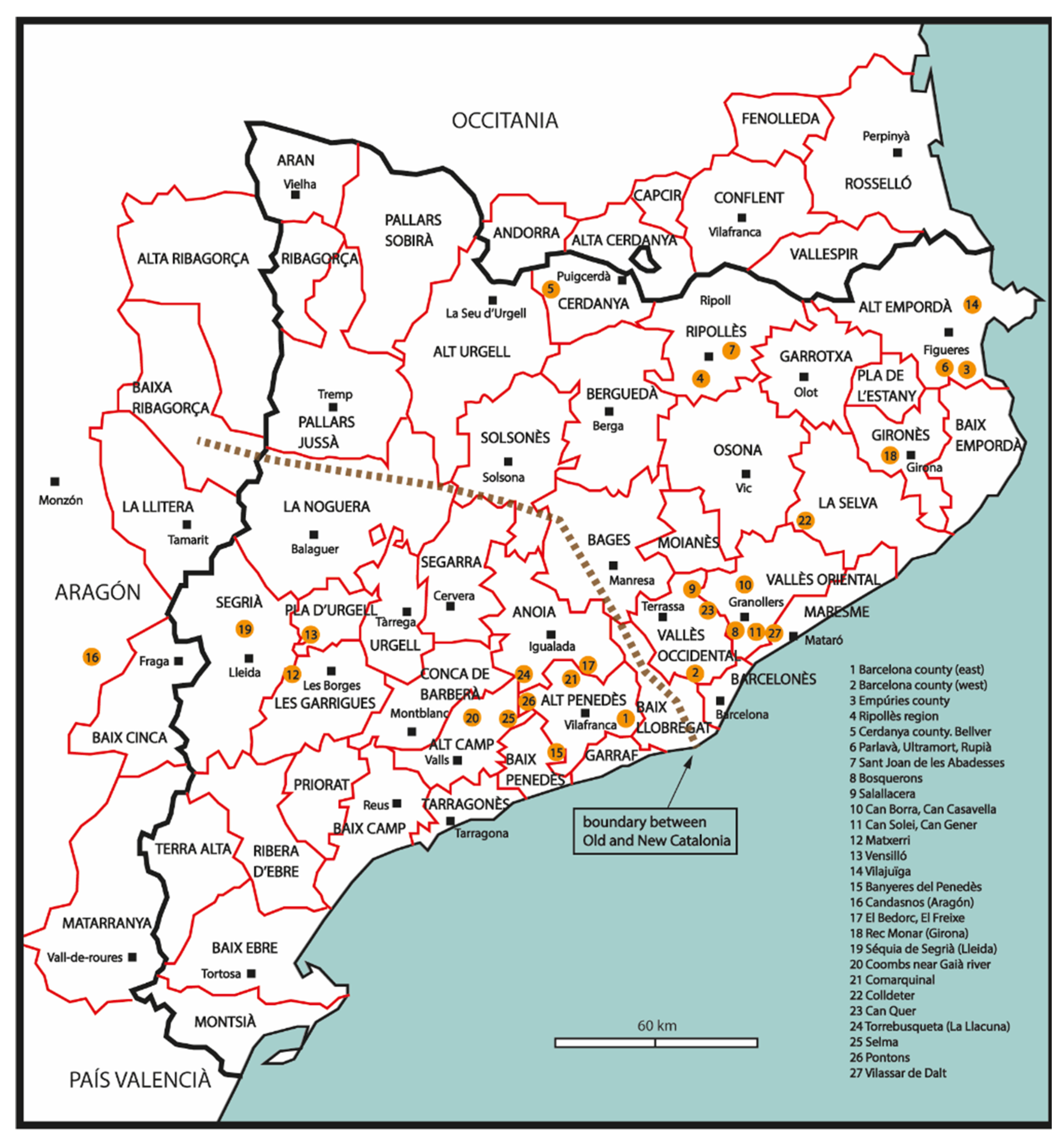
Figure 2.
Maps of two sectors of the County of Barcelona, located to the west and east of the Llobregat River. According to morphogenetic studies, the constructions that played a significant role in the formation of the various villages are indicated. (Source: map by J. Bolòs published in [15]).
Figure 2.
Maps of two sectors of the County of Barcelona, located to the west and east of the Llobregat River. According to morphogenetic studies, the constructions that played a significant role in the formation of the various villages are indicated. (Source: map by J. Bolòs published in [15]).
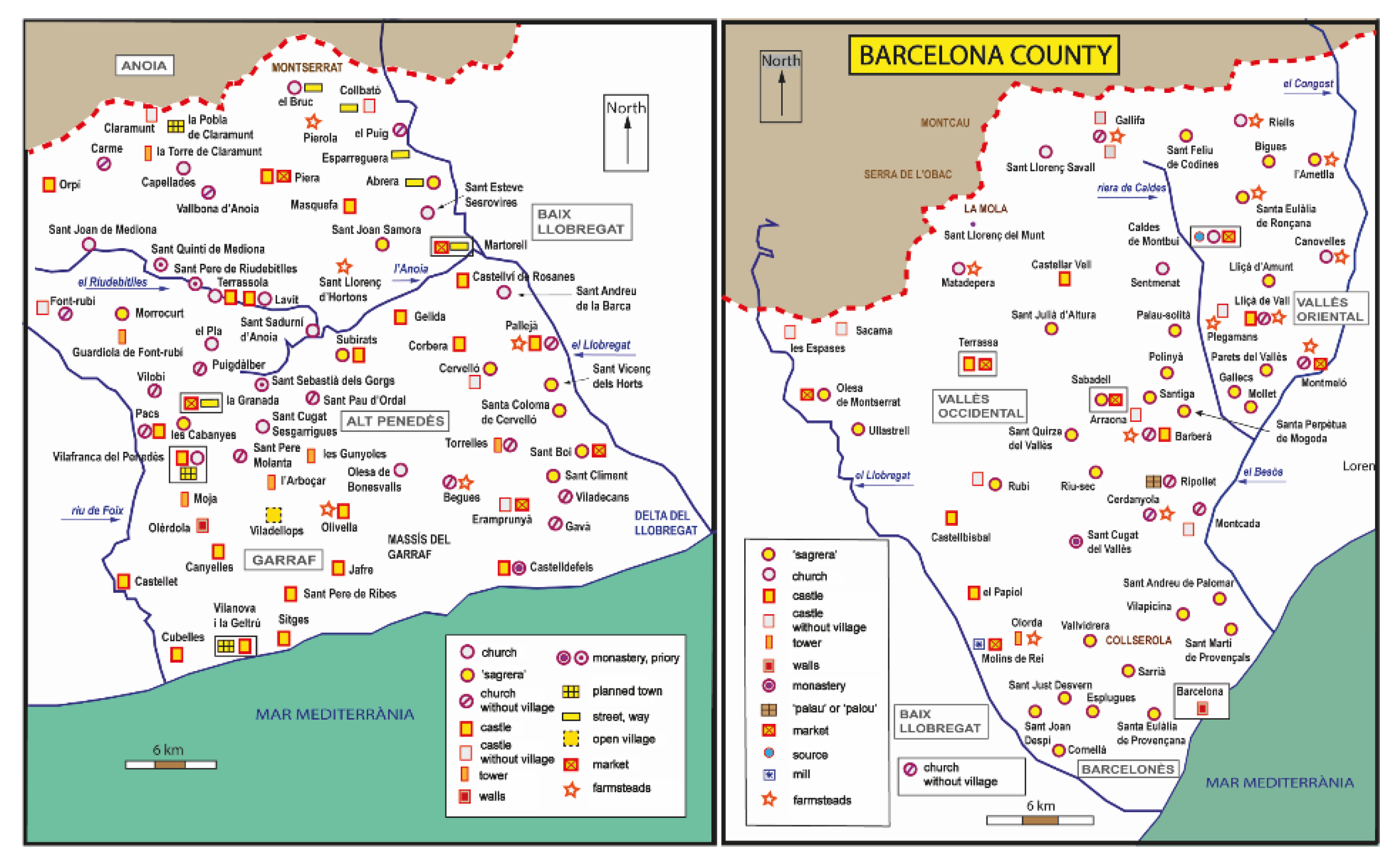
Figure 3.
The County of Empúries, as defined by its boundaries during the Carolingian period [20]. The constructions that played a significant role in the formation of various villages are indicated. (Source: map by J. Bolòs published in [19]).
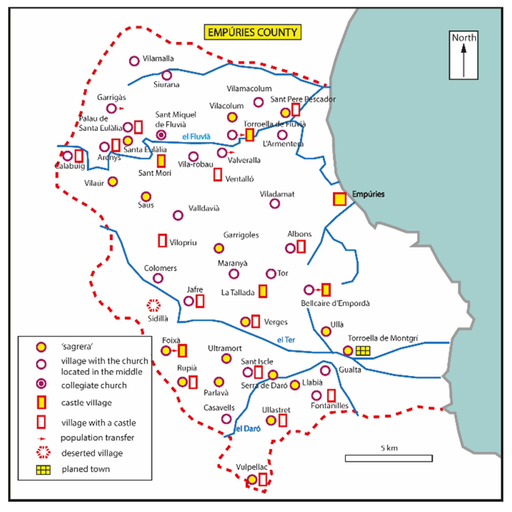
Figure 4.
The comarca of Ripollès. During the Carolingian period, it was divided among three counties: Cerdanya to the northwest, Besalú to the east, and Osona to the south. The map indicates the constructions that played a significant role in the formation of the various villages. (Source: map by J. Bolòs published in [22]).
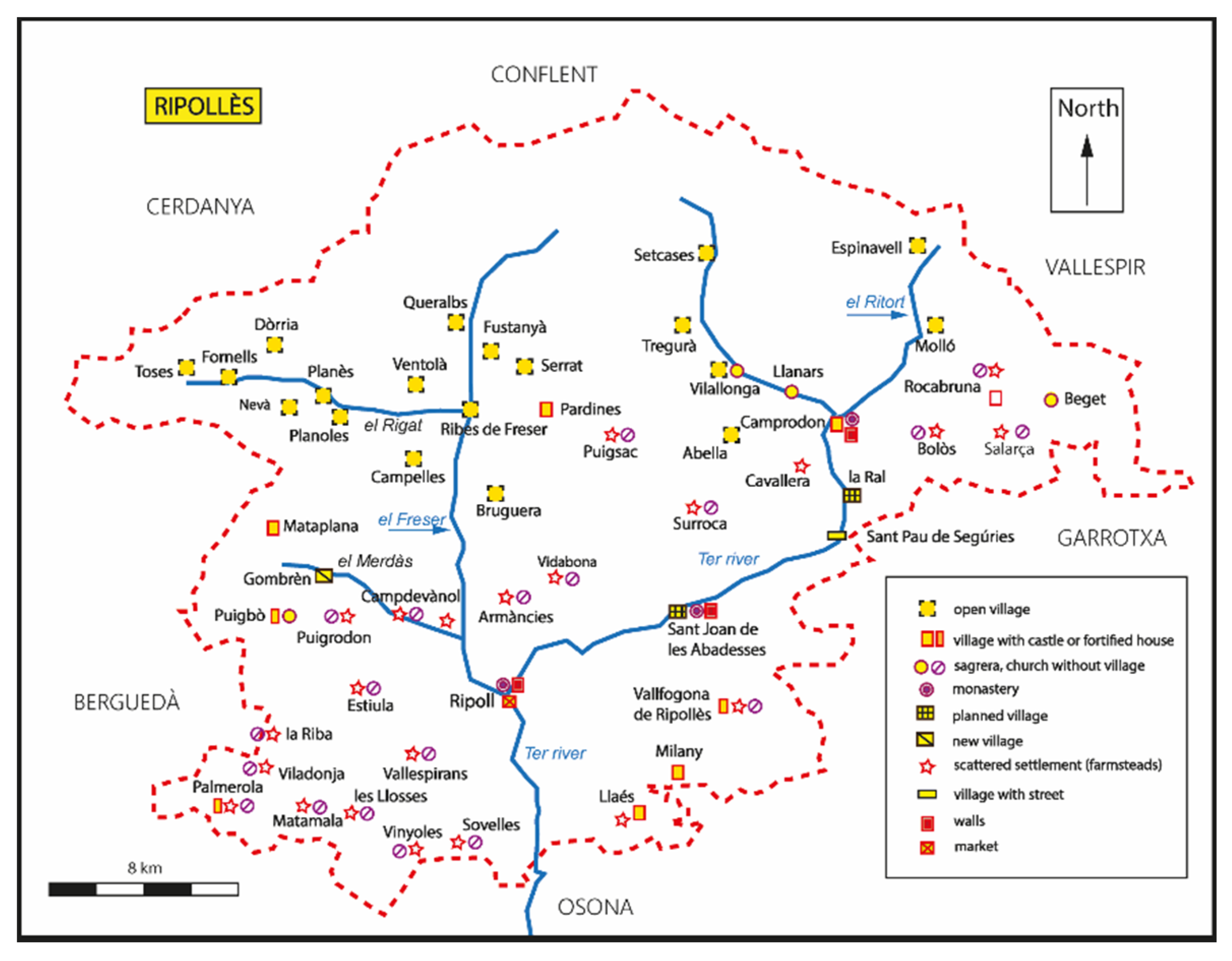
Figure 5.
The western sector of the County of Cerdanya. Approximate boundaries of the former pagus of Talló or of the later batllia of Bellver. The constructions that played a significant role in the formation of various villages are indicated. It can be observed that almost all villages in this area, situated above 1,000 m in altitude, were open settlements and developed in relation to individual homesteads.
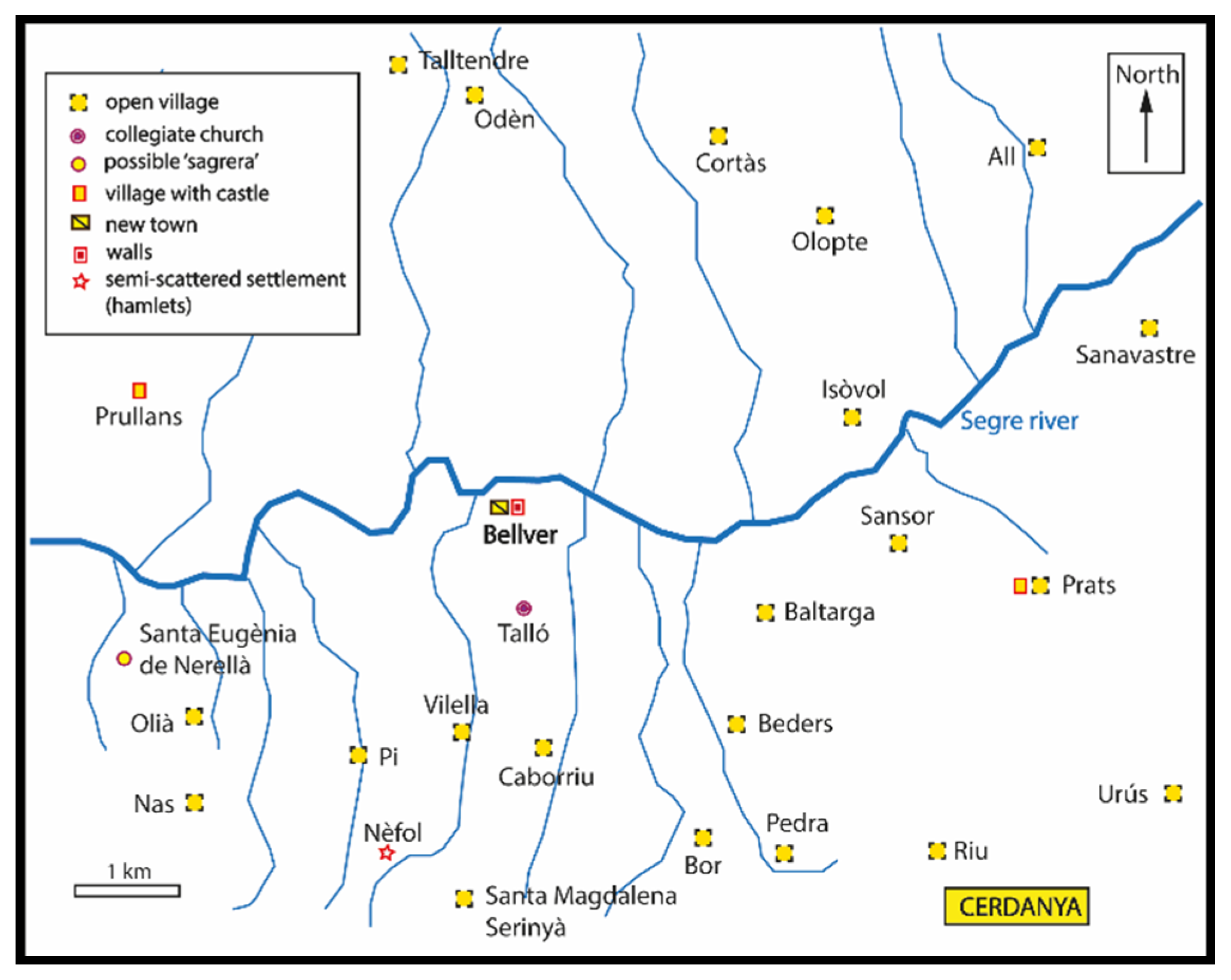
Figure 6.
The municipal boundaries of Ultramort, Rupià, and Parlavà (Baix Empordà). These three places are mentioned in a document dated 989. The map relates the three territories to areas whose shape is based on Roman-period land divisions. (Background aerial photography: © ICGC, 1956).
Figure 6.
The municipal boundaries of Ultramort, Rupià, and Parlavà (Baix Empordà). These three places are mentioned in a document dated 989. The map relates the three territories to areas whose shape is based on Roman-period land divisions. (Background aerial photography: © ICGC, 1956).
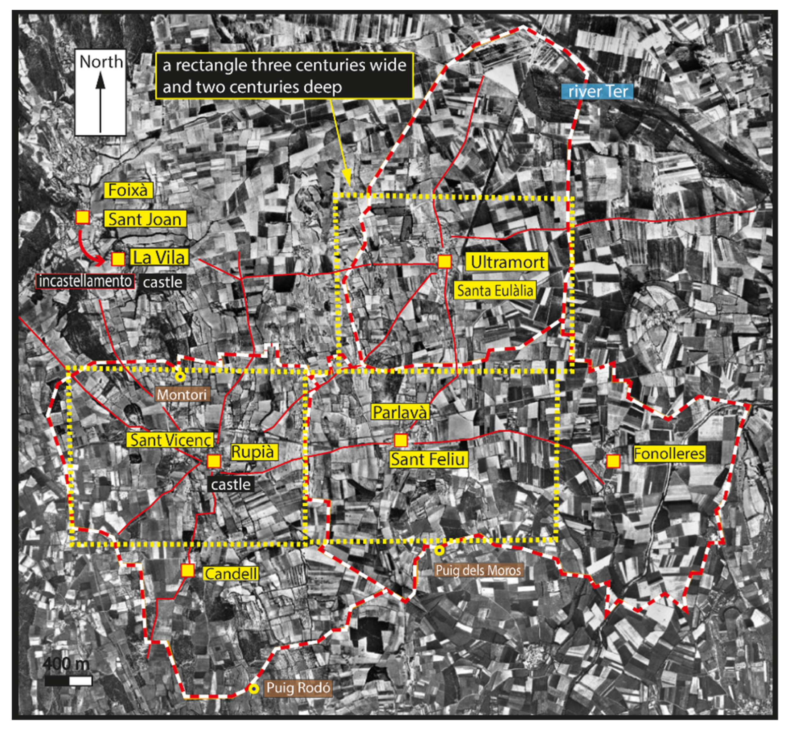
Figure 7.
Domain of the monastery of Sant Joan de les Abadesses in the valley of Sant Joan, east of Ripoll. The various settlements (hamlets and villae) mentioned in a document dated 913 are located. The number of families living there, and the probable boundaries of these inhabited places are also indicated. (Source: map by J. Bolòs published in [22]).
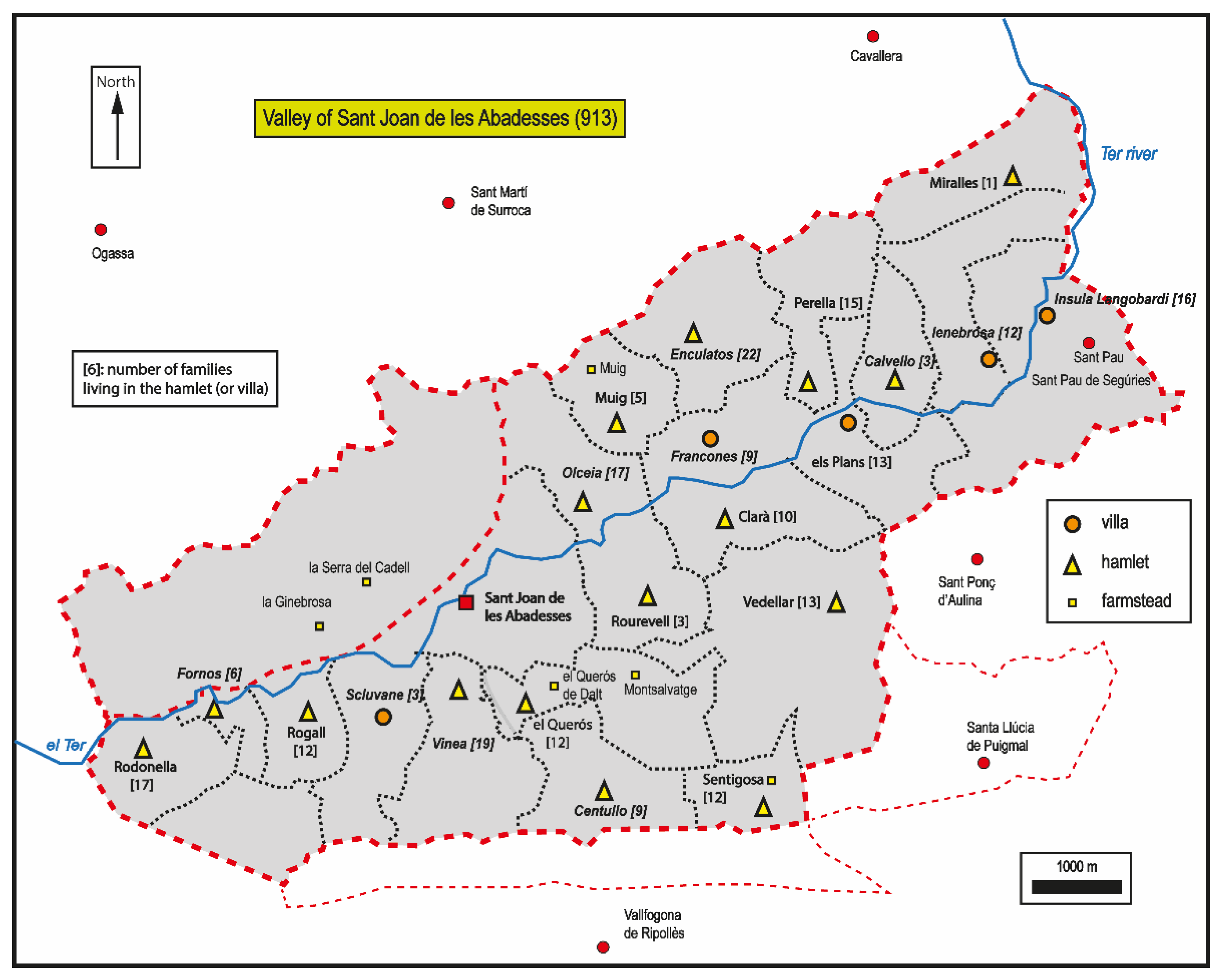
Figure 8.
Bosquerons (Montornès del Vallès, Vallès Oriental). Characteristics of the territory of an early medieval hamlet, according to a document dated 989. The settlement was located next to a road; behind it, there was woodland, and in front of it, extending to the Besòs River, cultivated land divided into strips. (Background aerial photography: © ICGC, 1956).
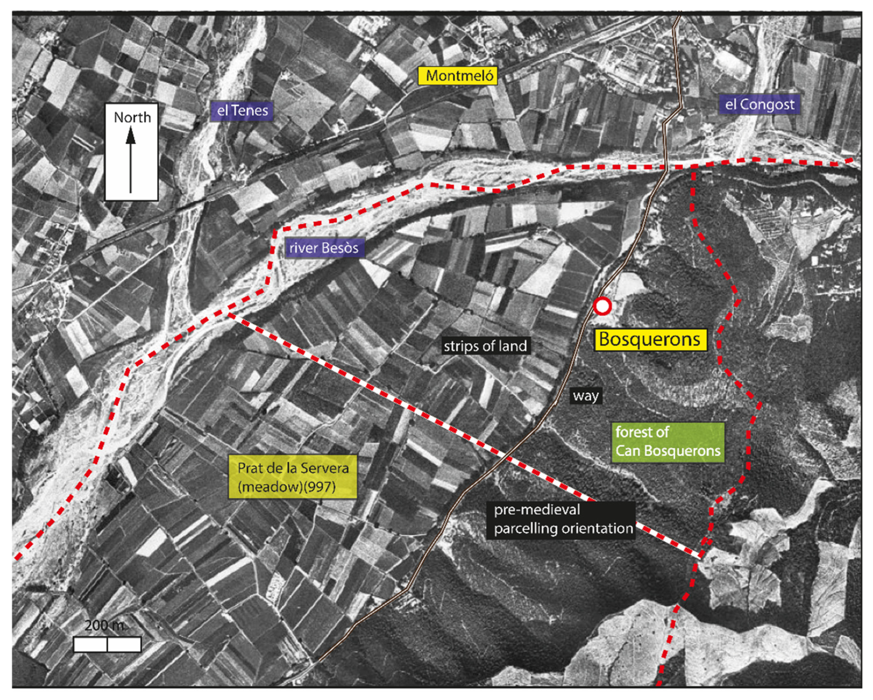
Figure 9.
Salallacera (Sant Llorenç Savall, Vallès Occidental). Characteristics of the territory of an early medieval hamlet, according to a document dated 961. Around the hamlet, now a mas, there were numerous braided terraces. Most of the dependent territory consisted of forest land. (Background aerial photography: © ICGC, 1956).
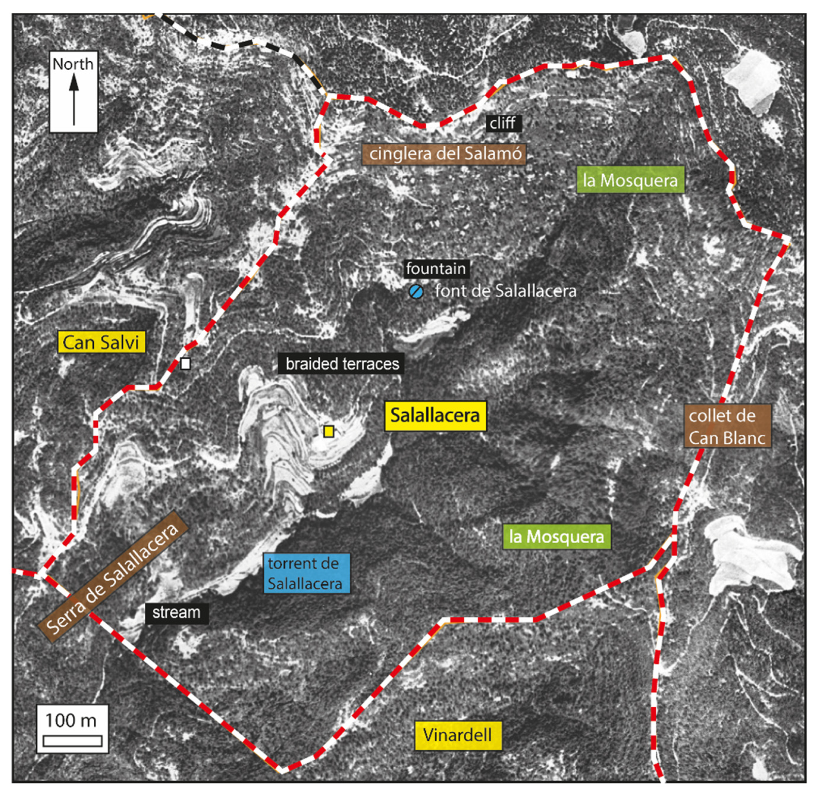
Figure 10.
Various farmsteads located in the municipality of Les Franqueses del Vallès (Vallès Oriental). Some have cultivated land bounded by concentric forms, while others have fields delimited by lines that follow the orientations of pre-medieval land divisions. (Background aerial photography: © ICGC, 1956).
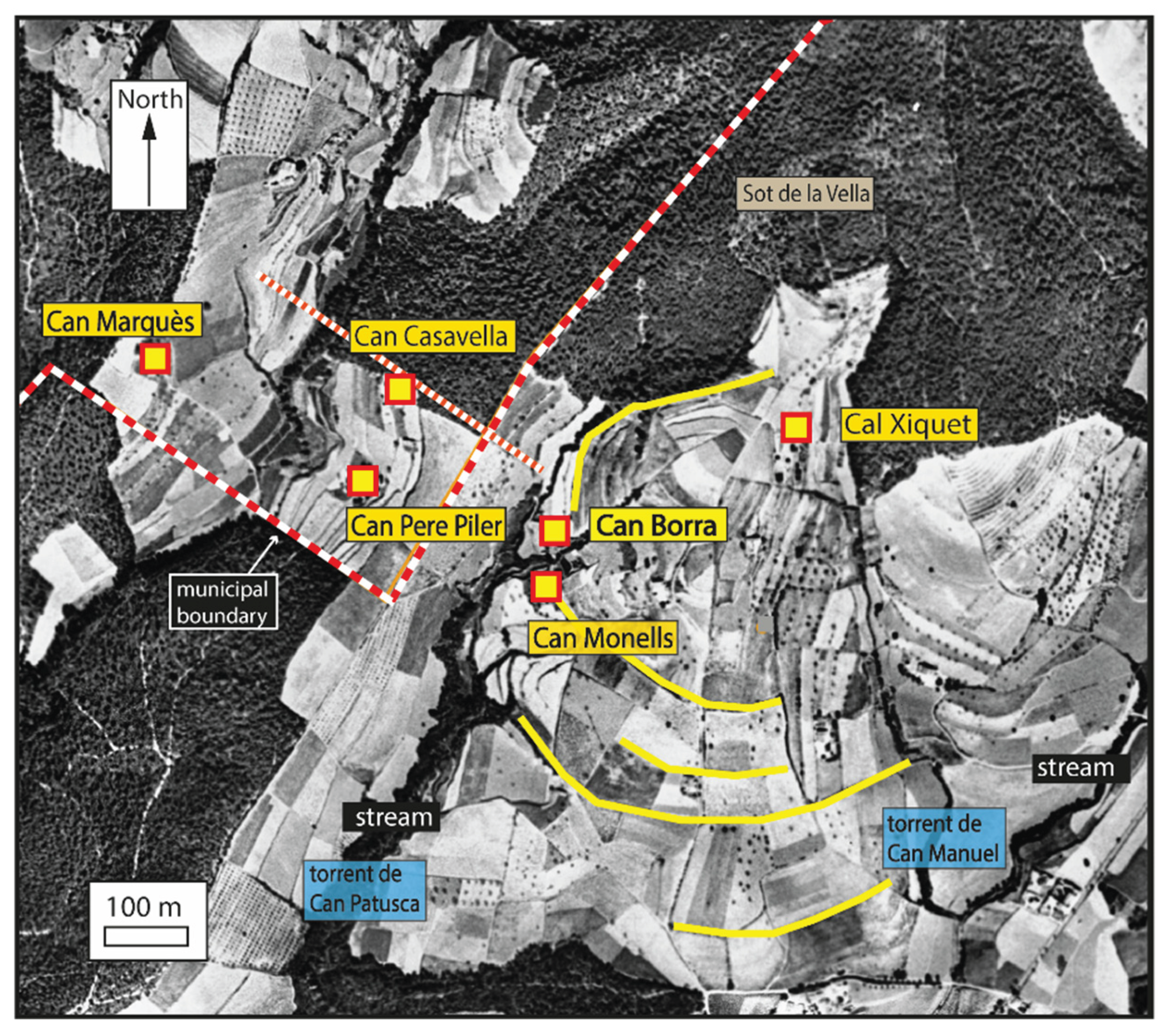
Figure 11.
Various farmsteads located in the municipality of La Roca del Vallès (Vallès Oriental). One, located to the west and possibly an early medieval hamlet, was built facing the fields and the Torrent de Valldoriolf. Others, to the east, are close to woodland and have cultivated land formed by small valleys and several terraces. (Background aerial photography: © ICGC, 1956).
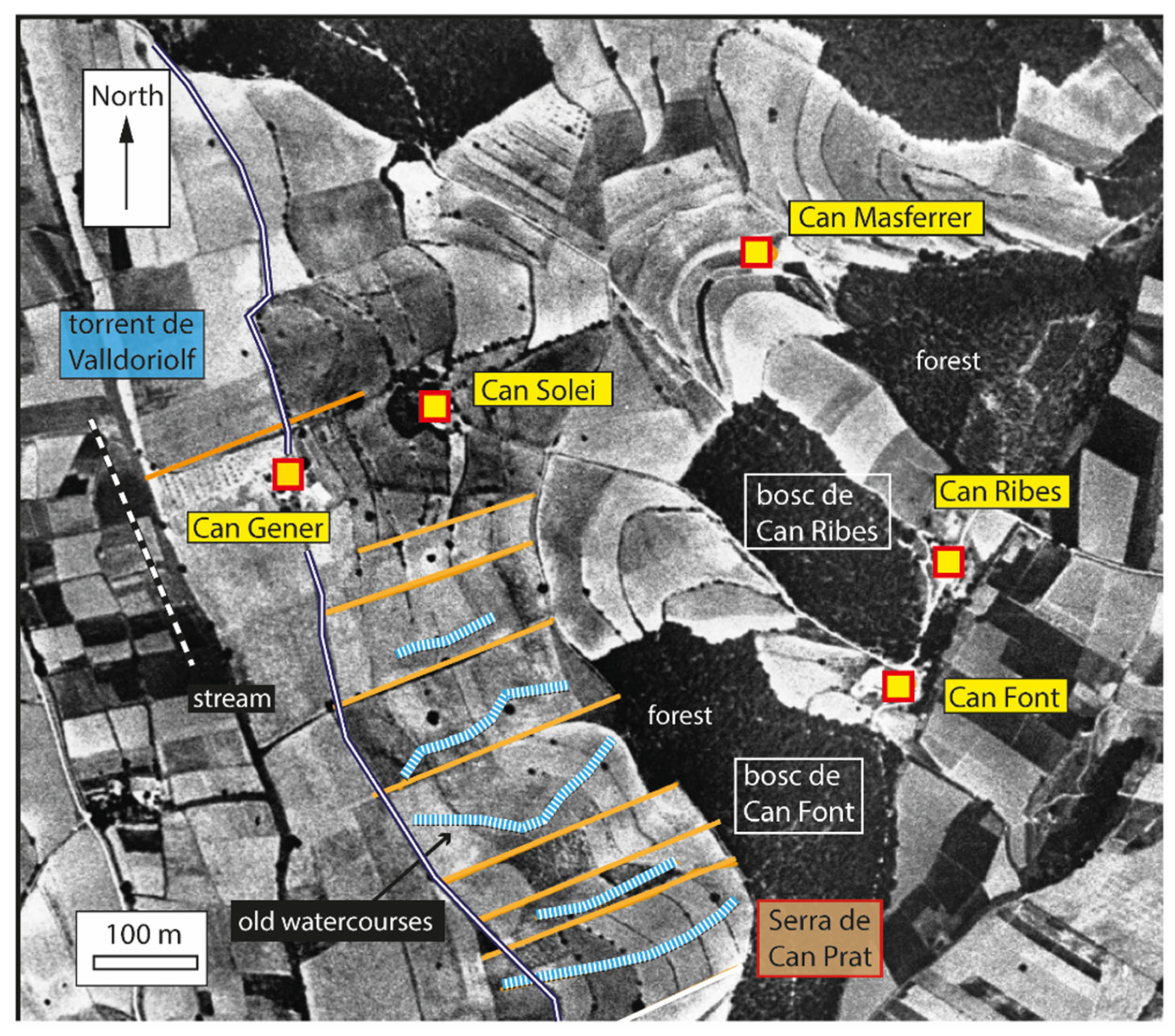
Figure 12.
The coomb (coma) of Matxerri (Castelldans, Les Garrigues). This extensive area of dry-farmed land is associated with an early medieval occupation that continued into the Islamic period and is still cultivated today. (Background aerial photography: © ICGC, 1956).
Figure 12.
The coomb (coma) of Matxerri (Castelldans, Les Garrigues). This extensive area of dry-farmed land is associated with an early medieval occupation that continued into the Islamic period and is still cultivated today. (Background aerial photography: © ICGC, 1956).
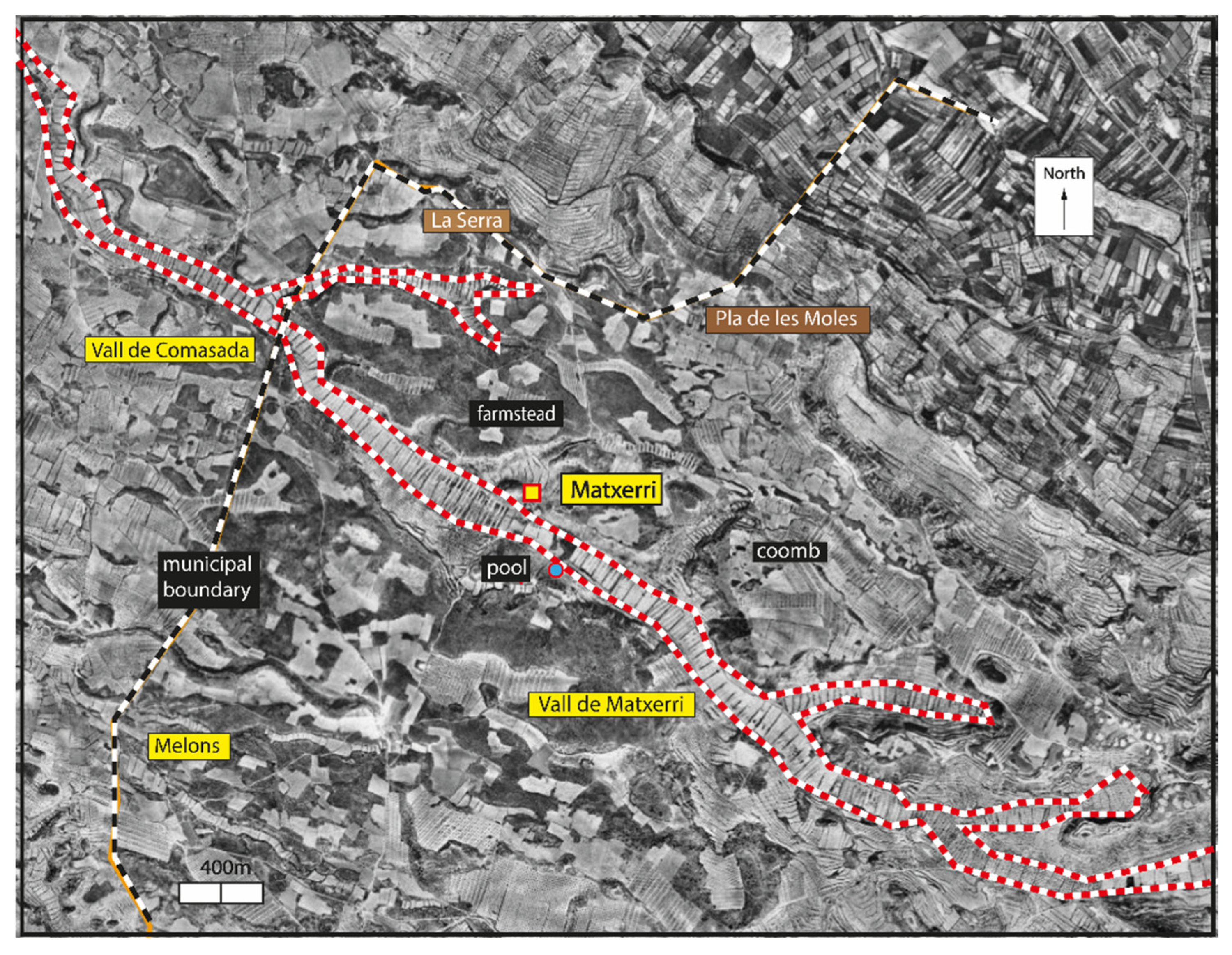
Figure 13.
Vensilló (Els Alamús, Segrià). This territory, currently irrigated, was probably dry farmland in the medieval period. Its boundaries, fossilised over the centuries, coincide with livestock droveways and with orientations of pre-medieval land divisions. (Background aerial photography: © ICGC, 1956).
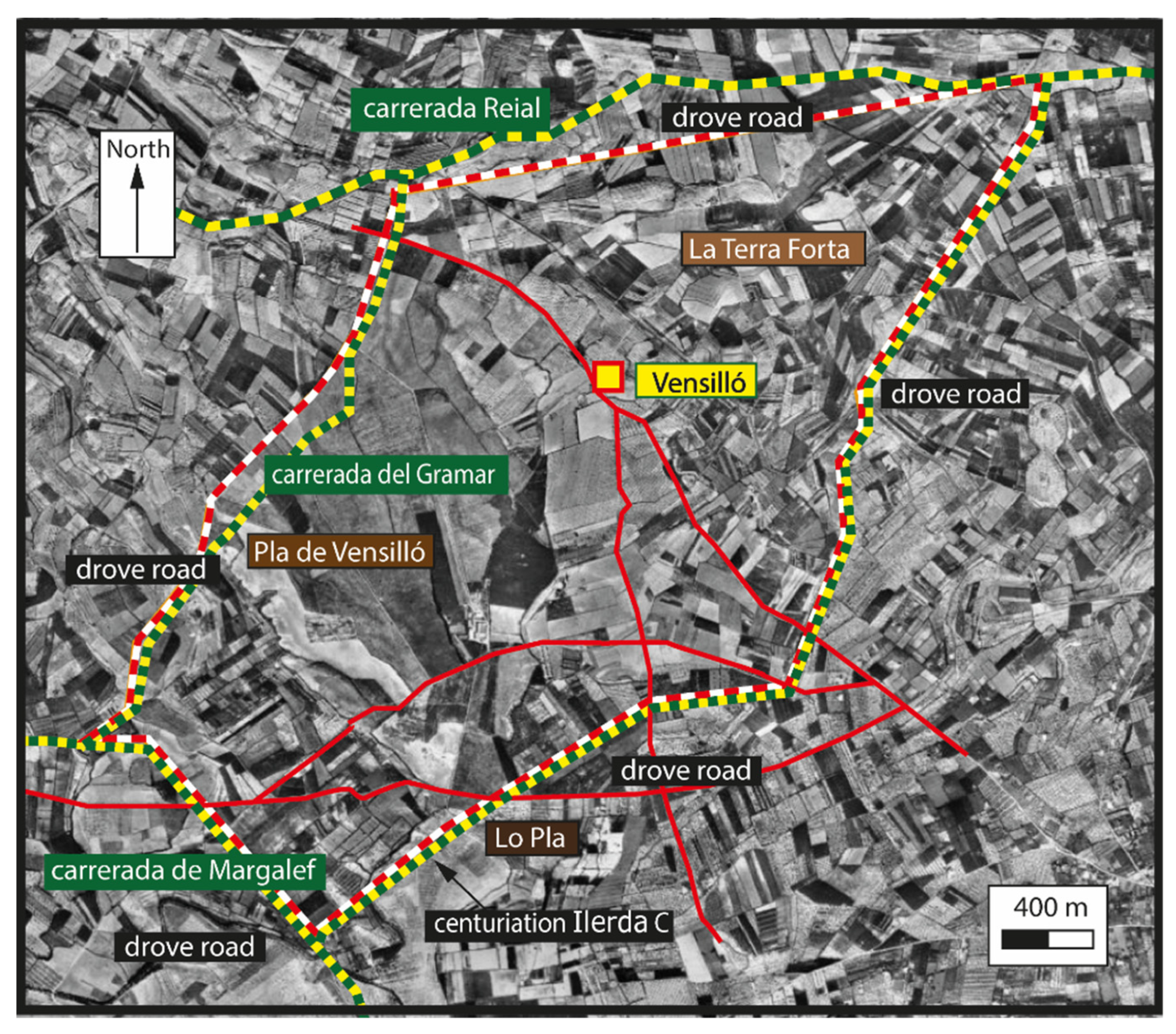
Figure 14.
Vilajuïga (Alt Empordà). In this territory, we observe evidence of Roman-period centuriation and various concentric forms, reflecting a process of occupation likely during the Early Middle Ages. (Background aerial photography: © ICGC, 1956).
Figure 14.
Vilajuïga (Alt Empordà). In this territory, we observe evidence of Roman-period centuriation and various concentric forms, reflecting a process of occupation likely during the Early Middle Ages. (Background aerial photography: © ICGC, 1956).
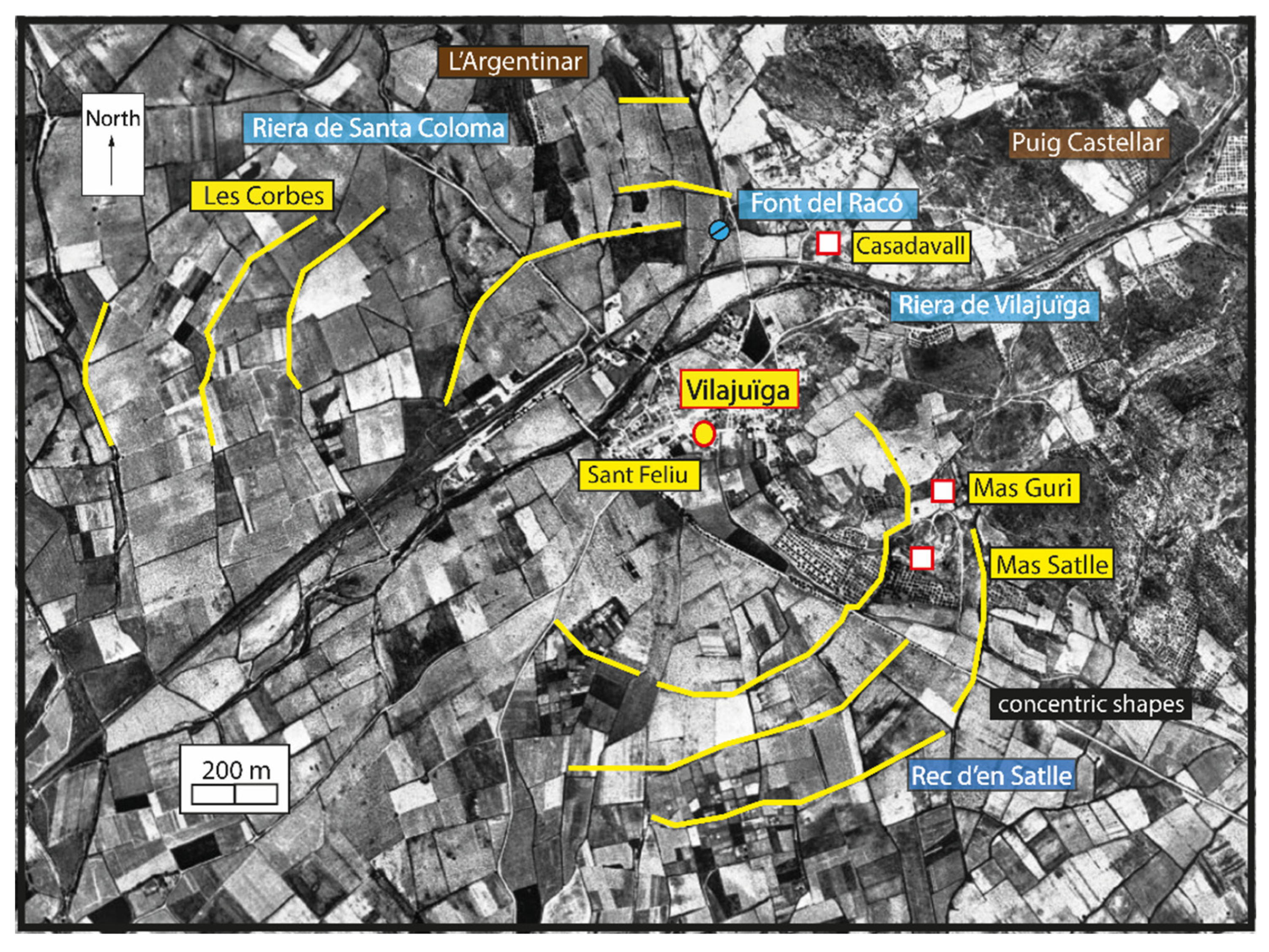
Figure 15.
Banyeres del Penedès (Baix Penedès). In this territory, we observe evidence of Roman-period centuriation and various concentric forms, reflecting a process of occupation likely dating to the 10th century. (Background aerial photography: © ICGC, 1956).
Figure 15.
Banyeres del Penedès (Baix Penedès). In this territory, we observe evidence of Roman-period centuriation and various concentric forms, reflecting a process of occupation likely dating to the 10th century. (Background aerial photography: © ICGC, 1956).
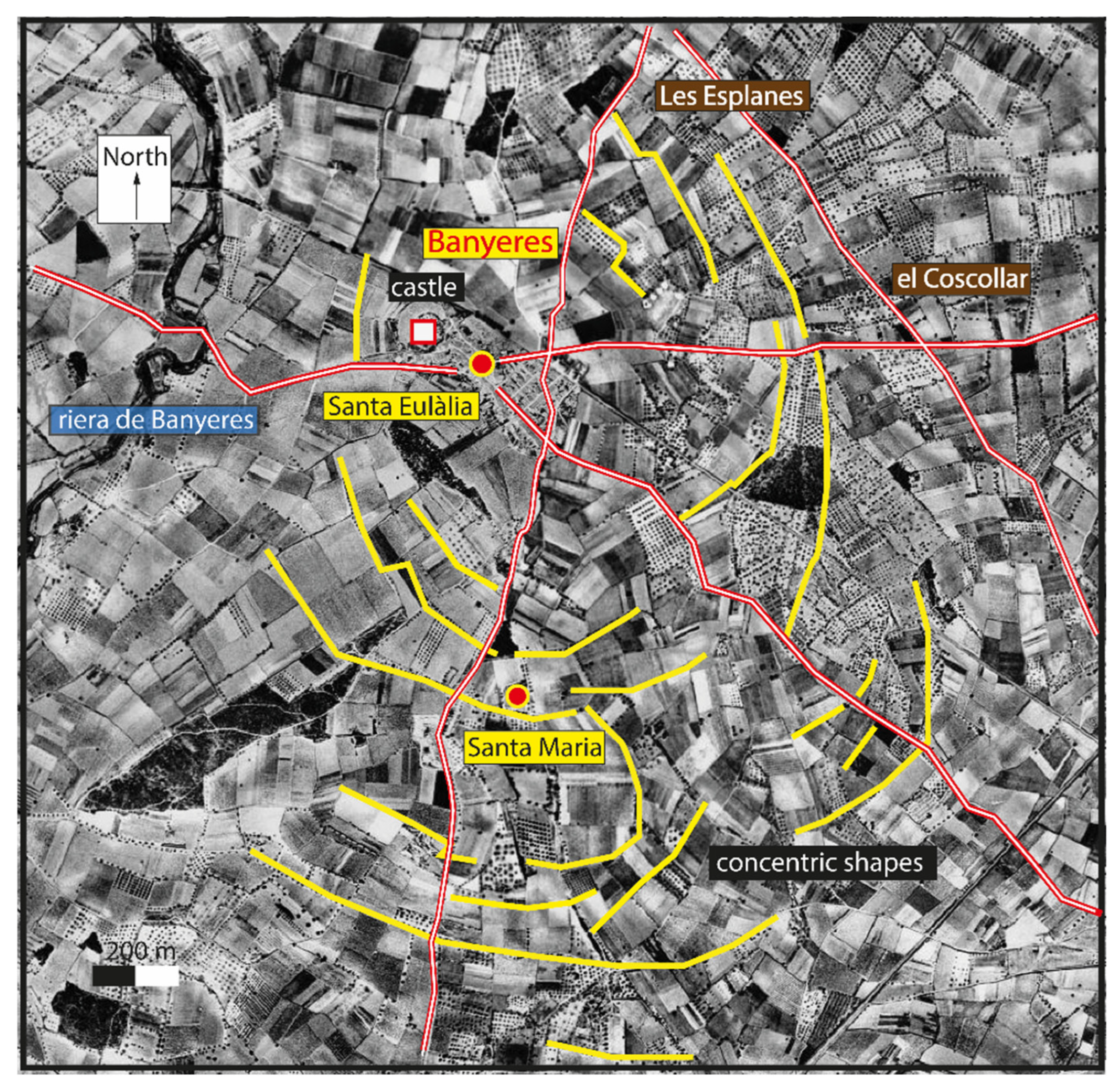
Figure 16.
Candasnos (Aragón). The territory, probably organised in the 13th century, is divided into several rings devoted to habitation, fodder production, and cereal cultivation. (Background aerial photography: © IGN, current).
Figure 16.
Candasnos (Aragón). The territory, probably organised in the 13th century, is divided into several rings devoted to habitation, fodder production, and cereal cultivation. (Background aerial photography: © IGN, current).
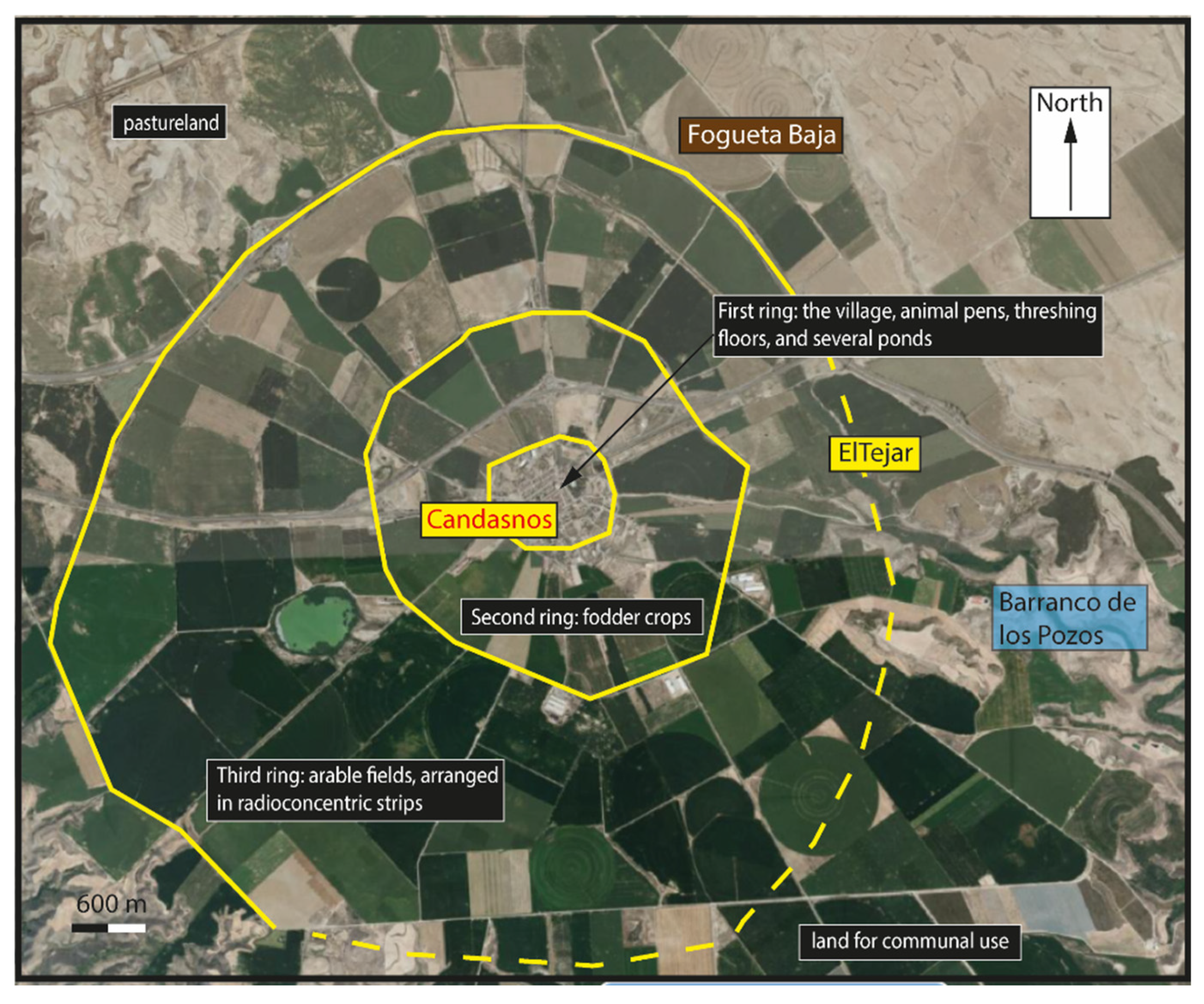
Figure 17.
Strips of land located between El Bedorc and El Freixe (Piera, Anoia). Although such strips usually date to the High Middle Ages, in this case, due to the precision of their forms and the presence of a Visigothic slab-grave necropolis, they are thought to date to the Early Middle Ages. (Background aerial photography: © ICGC, 1956).
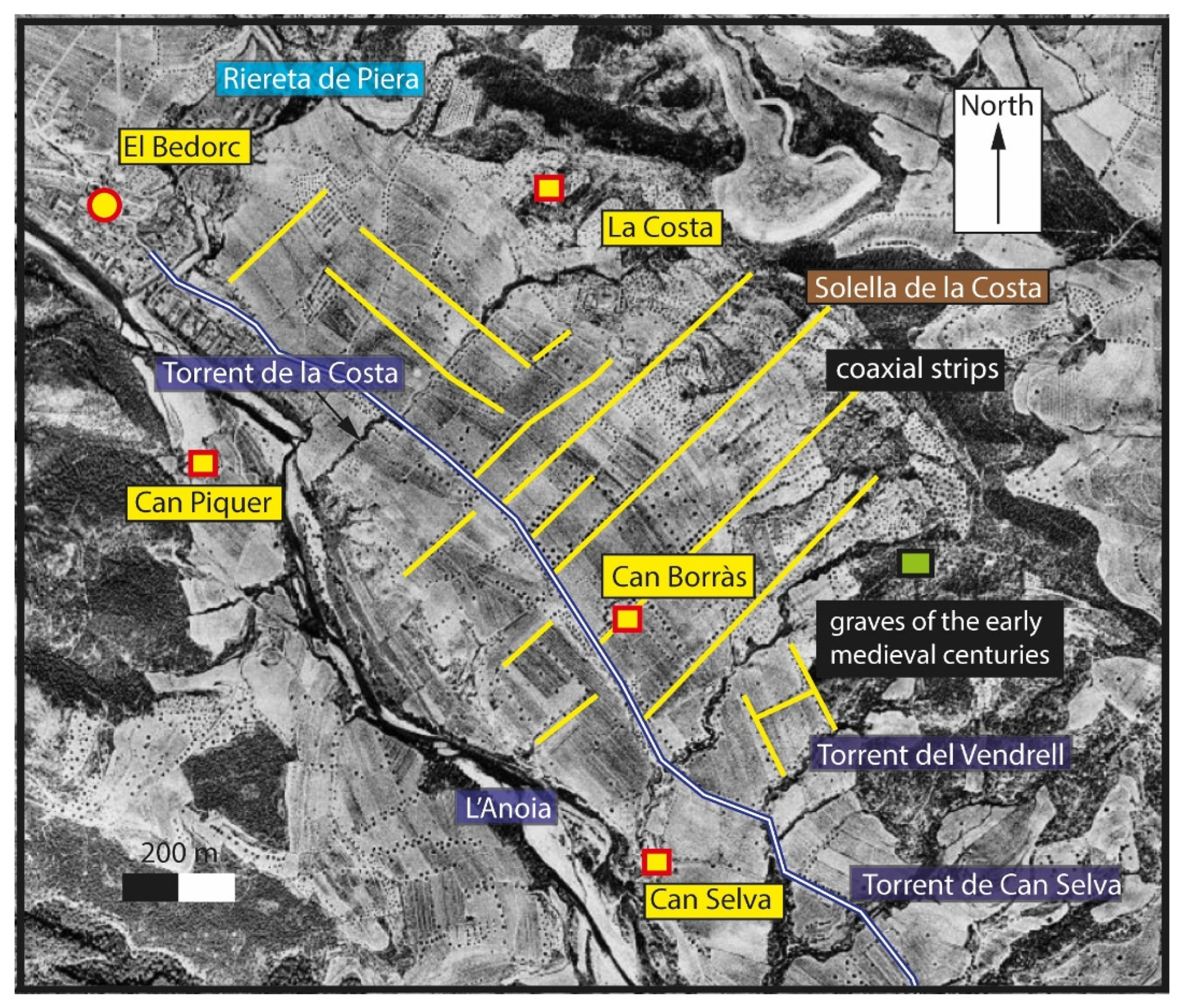
Figure 18.
The Rec Monar (or Séquia Monar), mill canal, draws water from the Ter River and conveys it almost as far as Girona. It is mentioned in the Carolingian period and may have existed even before the brief years of Islamic rule. (Background aerial photography: © ICGC, 1956).
Figure 18.
The Rec Monar (or Séquia Monar), mill canal, draws water from the Ter River and conveys it almost as far as Girona. It is mentioned in the Carolingian period and may have existed even before the brief years of Islamic rule. (Background aerial photography: © ICGC, 1956).
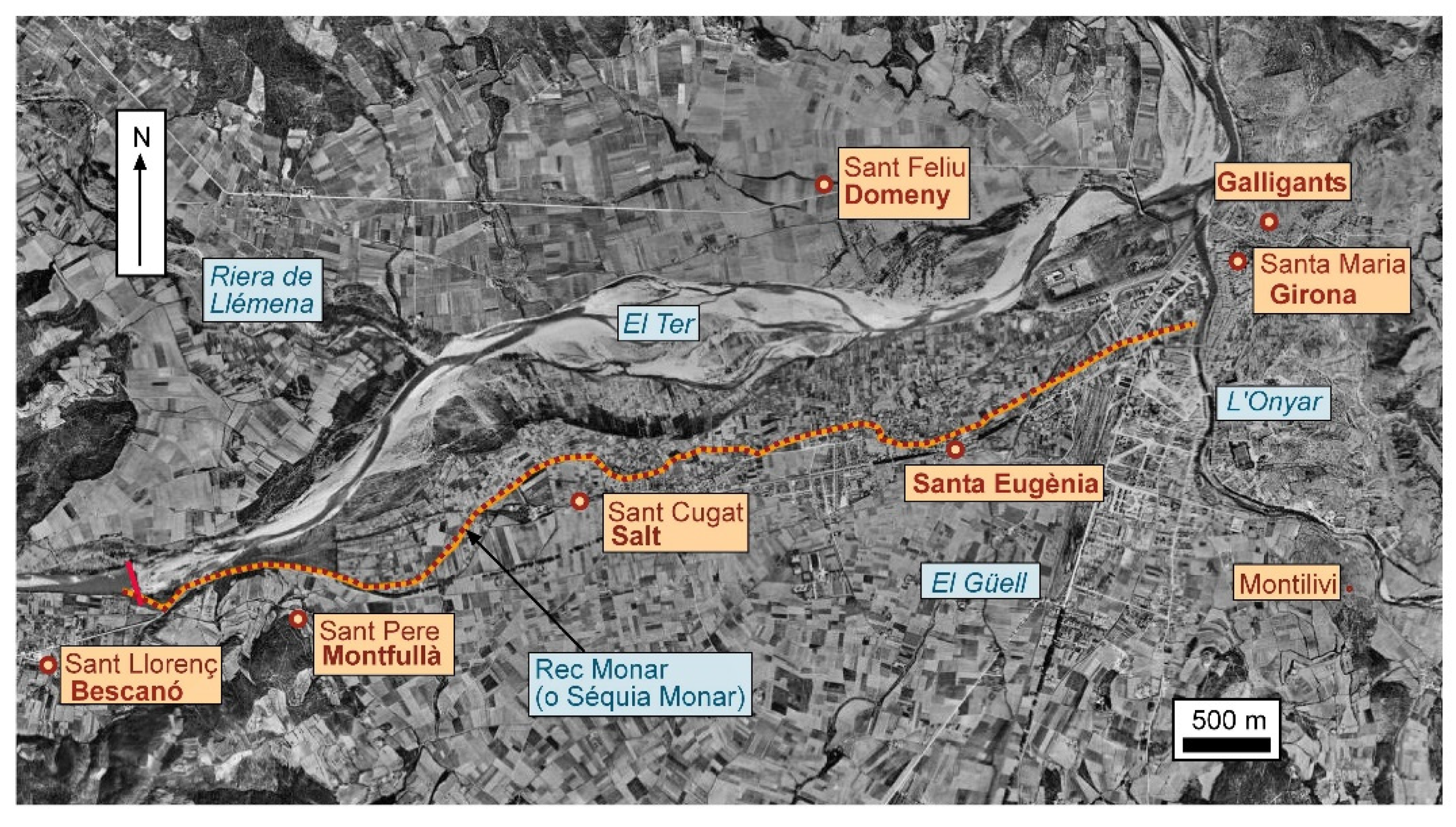
Figure 19.
Section of the Séquia de Segrià (now Canal de Pinyana) (Segrià). This irrigation canal was probably constructed around the year 1000 by the community governing the city of Lleida during the Islamic period. Earlier, however, small irrigated areas already existed along the banks of the various channels of the so-called Reguer Gran and its tributaries. (Map background: © IGN LiDAR).
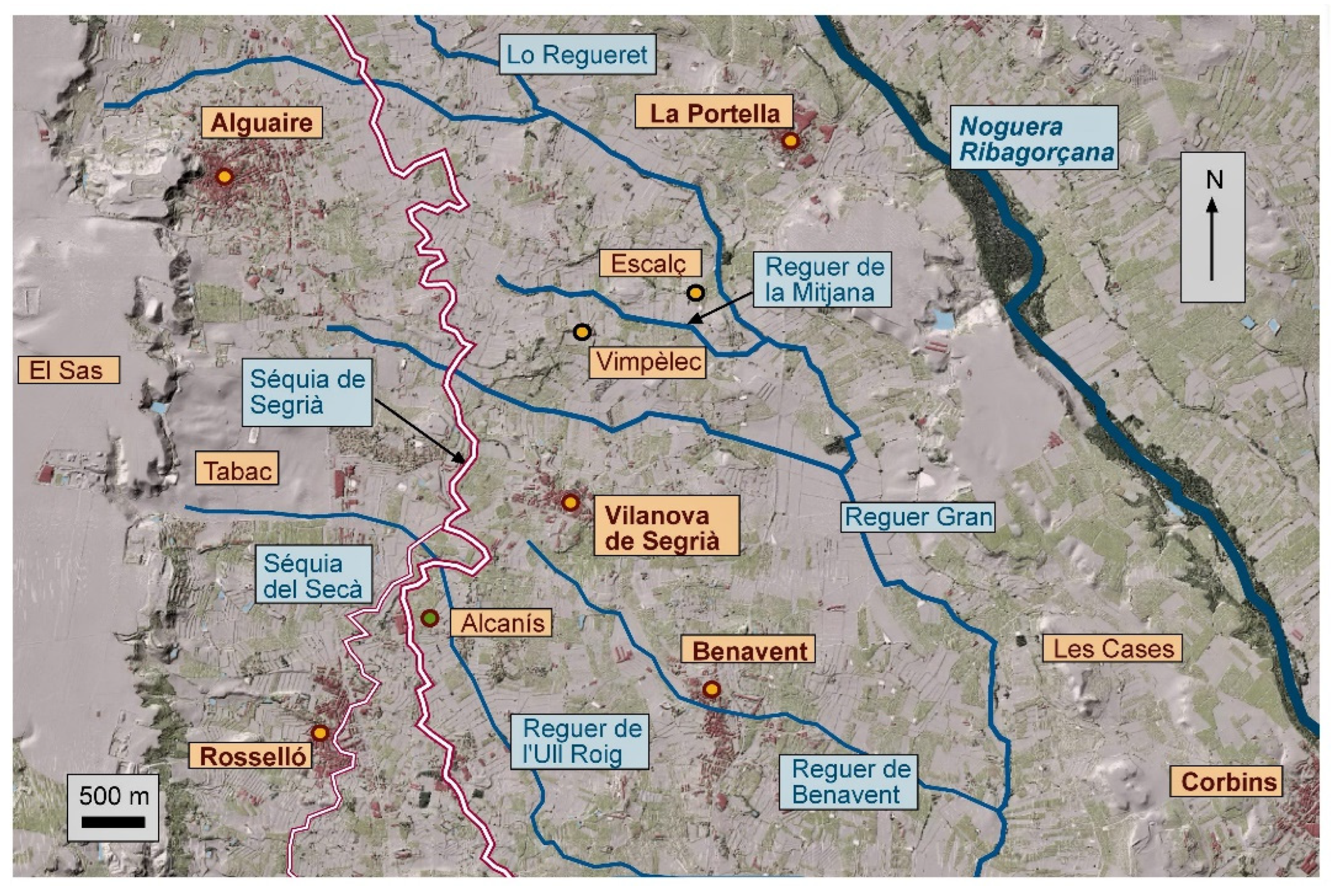
Figure 20.
Coombs (comes) are located west of the Gaià River (Aiguamúrcia, Alt Camp). These coombs were probably cultivated in the Early Middle Ages and were further expanded around 1193. They are crossed by a very old path linking Sant Pere de Gaià and the village of Cabra del Camp. (Background aerial photography: © ICGC, 1956).
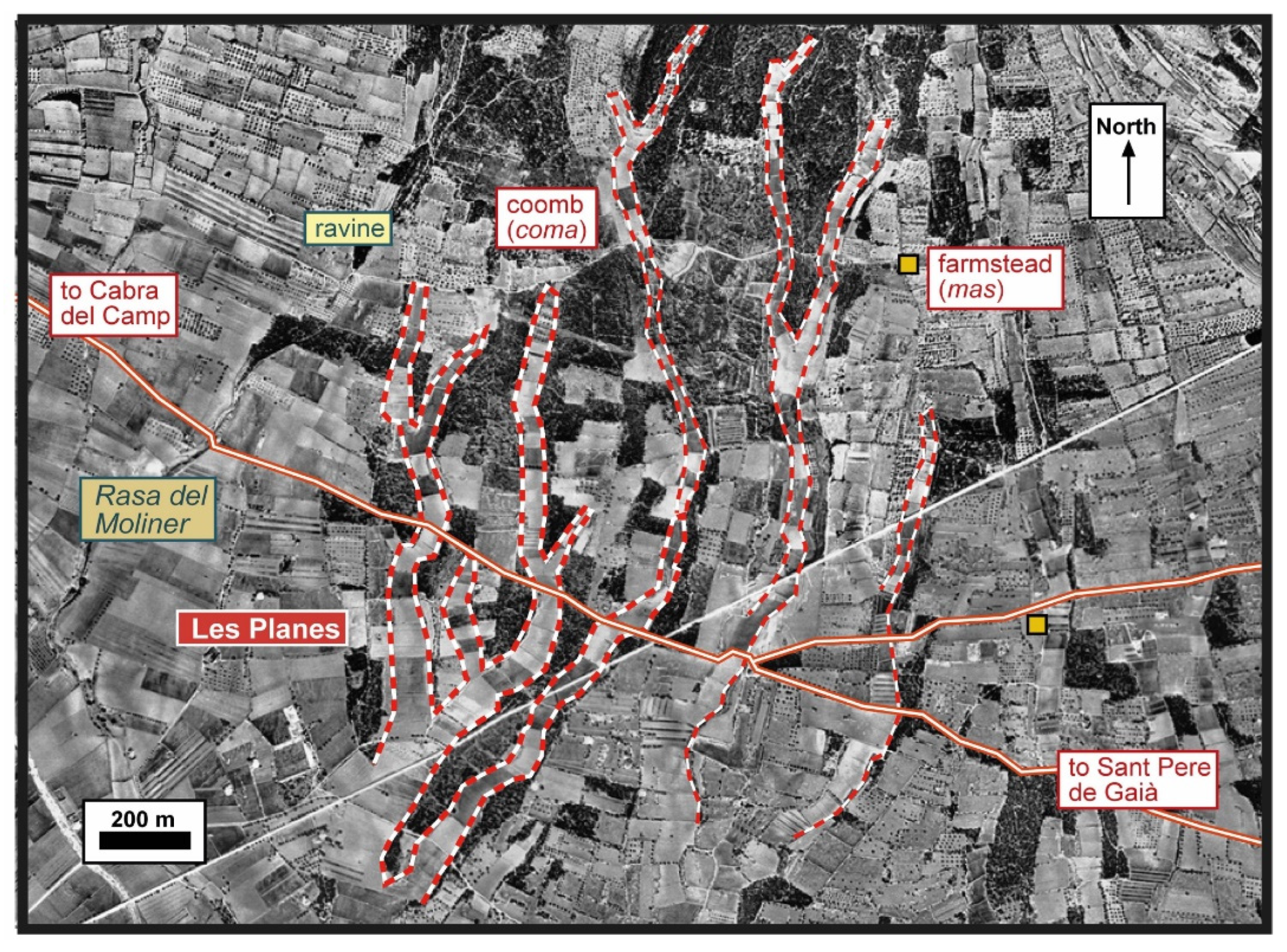
Figure 21.
Comarquinal (Sant Quintí de Mediona, Alt Penedès). As indicated by the place name (Coma d’Arquinald), this is a fertile coomb that has probably been cultivated since the Early Middle Ages. (Background aerial photography: © ICGC, 1956).
Figure 21.
Comarquinal (Sant Quintí de Mediona, Alt Penedès). As indicated by the place name (Coma d’Arquinald), this is a fertile coomb that has probably been cultivated since the Early Middle Ages. (Background aerial photography: © ICGC, 1956).
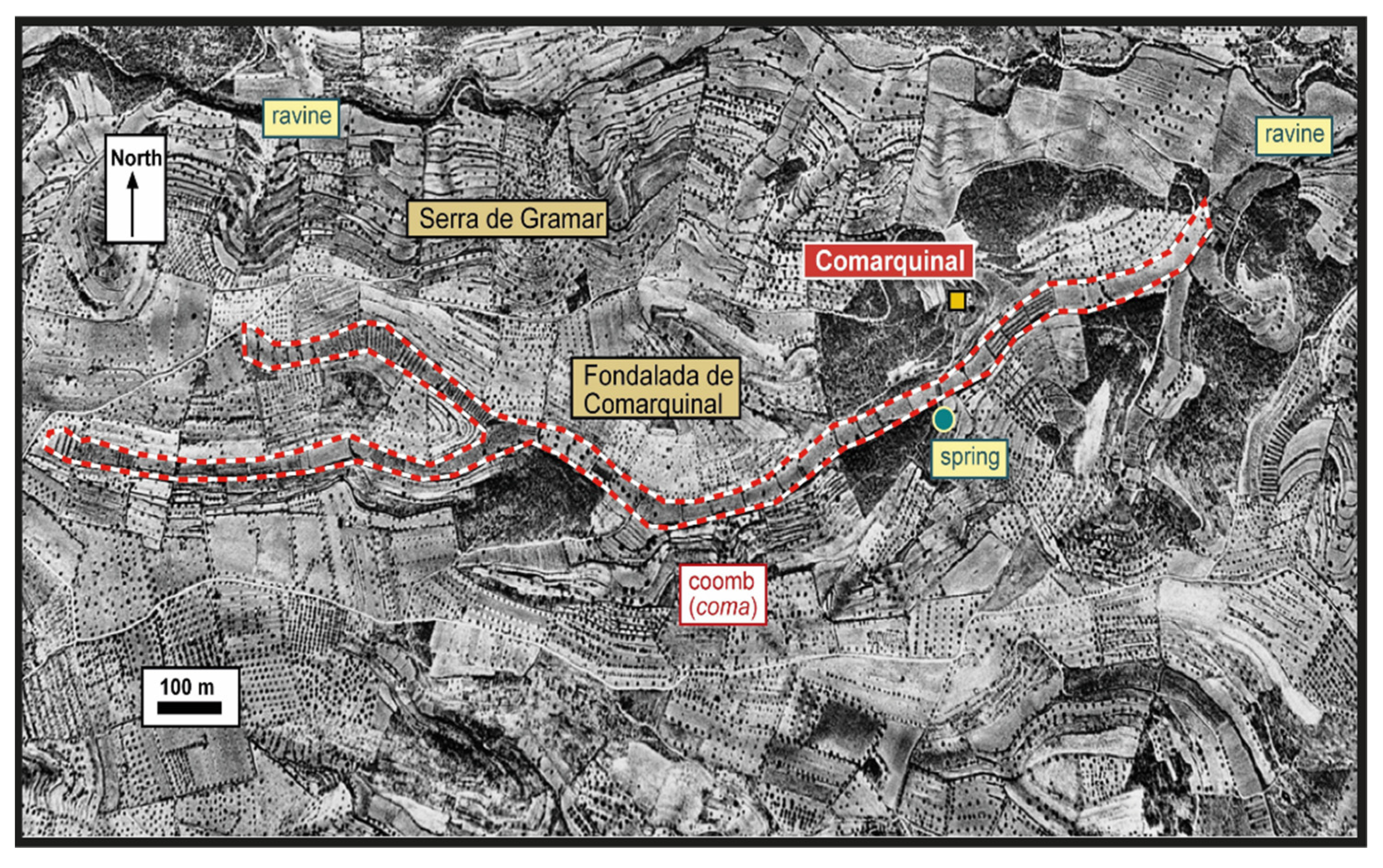
Figure 22.
Farmsteads of Vilanova and Colldeter (Arbúcies, La Selva). These two places (which were probably hamlets) were mentioned as early as 923 and were likely established in the first years of the Carolingian period. Their lands consist mainly of braided terraces and are surrounded by forest land. (Background aerial photography: © ICGC, 1956).
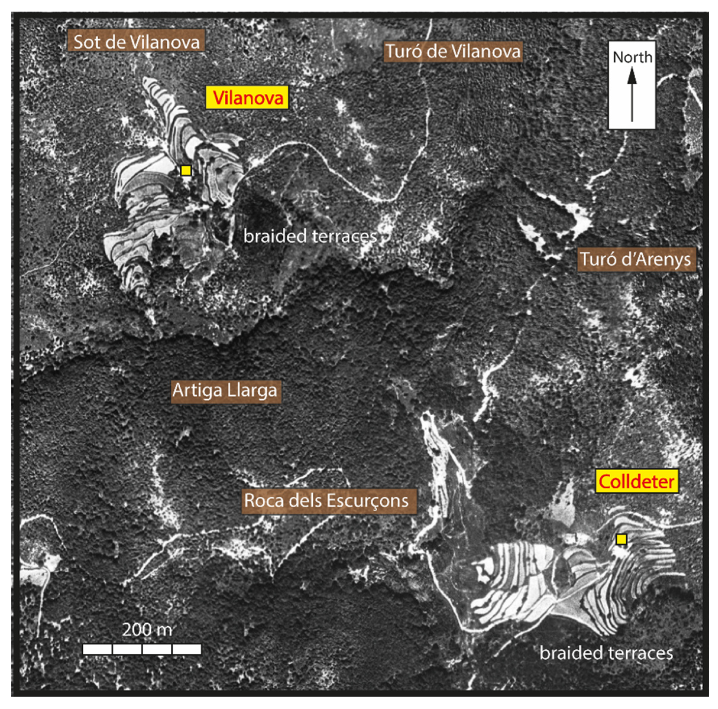
Figure 23.
Farmsteads of Can Quer and Ca n’Ametller (Castellar del Vallès, Vallès Occidental). These masos may have been created in the High Middle Ages. Their land consists mainly of braided terraces. (Background aerial photography: © ICGC, 1956).
Figure 23.
Farmsteads of Can Quer and Ca n’Ametller (Castellar del Vallès, Vallès Occidental). These masos may have been created in the High Middle Ages. Their land consists mainly of braided terraces. (Background aerial photography: © ICGC, 1956).
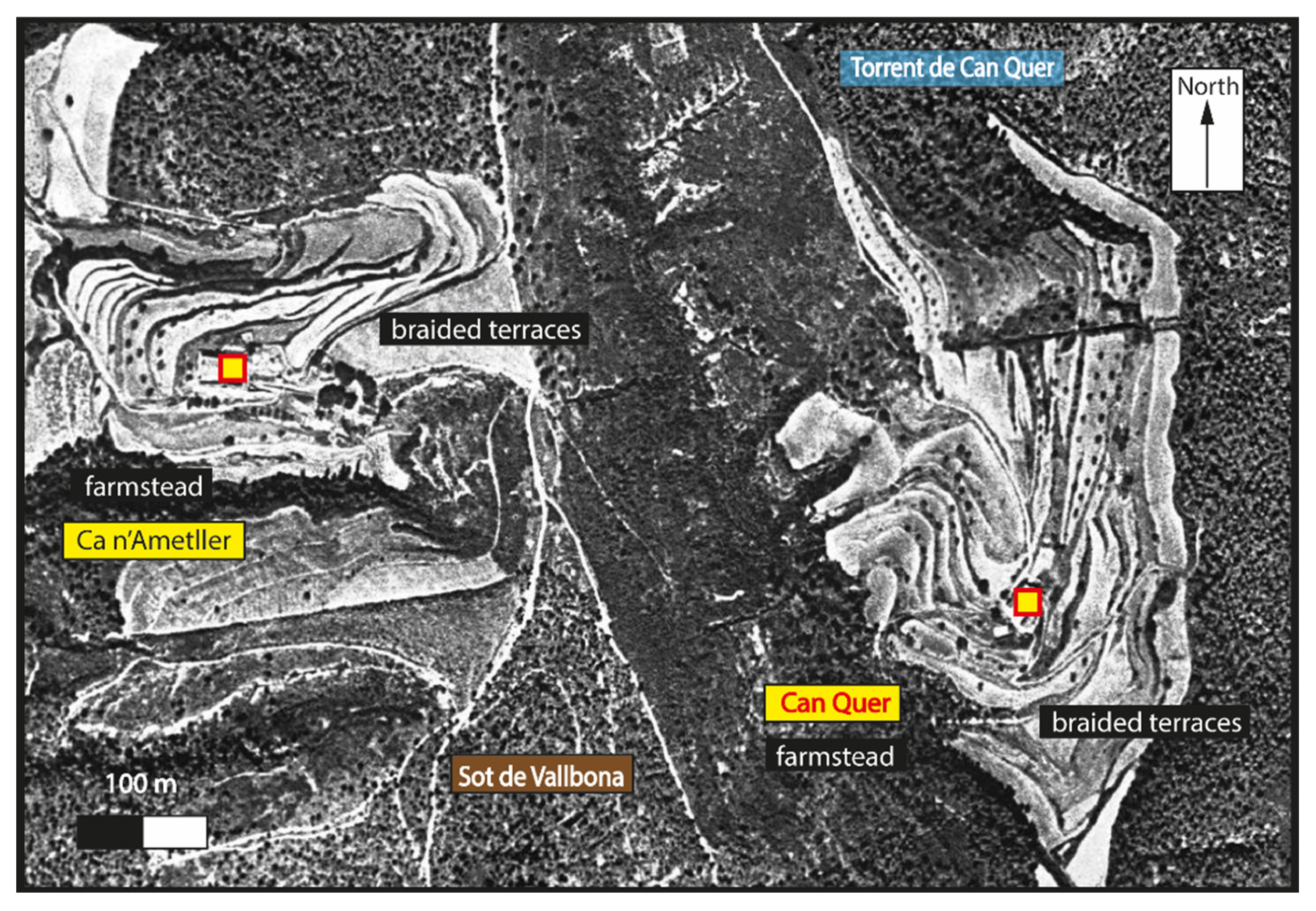
Figure 24.
Torrebusqueta (La Llacuna, Anoia). Area possibly cultivated since the Early Middle Ages. During the medieval period, the space was organised into several wide strips, fragmented on terraces, and some farmsteads were built. (Background aerial photography: © ICGC, 1956).
Figure 24.
Torrebusqueta (La Llacuna, Anoia). Area possibly cultivated since the Early Middle Ages. During the medieval period, the space was organised into several wide strips, fragmented on terraces, and some farmsteads were built. (Background aerial photography: © ICGC, 1956).
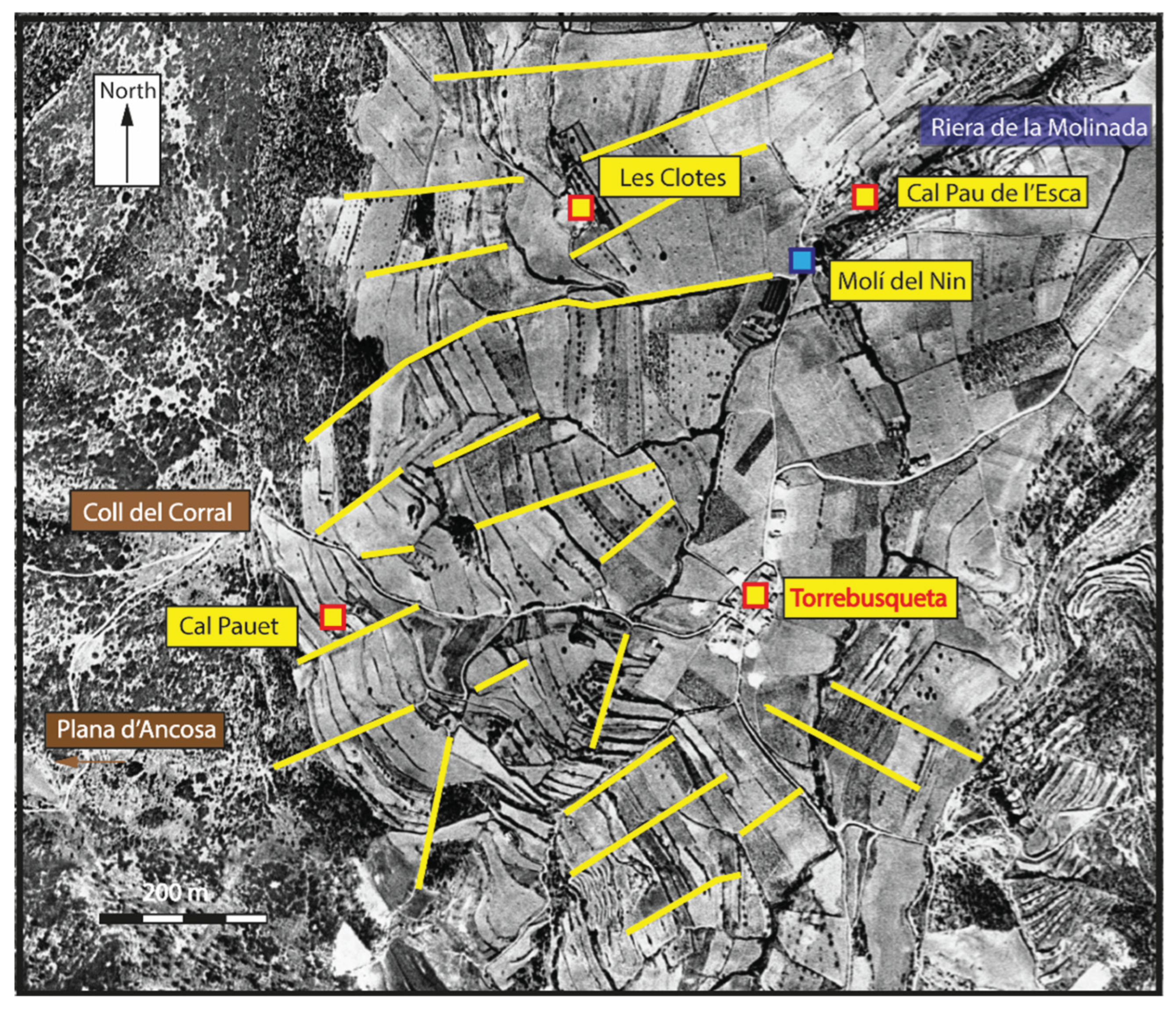
Figure 25.
Selma (Aiguamúrcia, Alt Camp). Around the castle, the village, and the church, located on elevated ground, several braided terraces were constructed. Further downslope, there were larger fields and several coombs. This site has been inhabited at least since the Islamic period. (Background aerial photography: © ICGC, 1956).
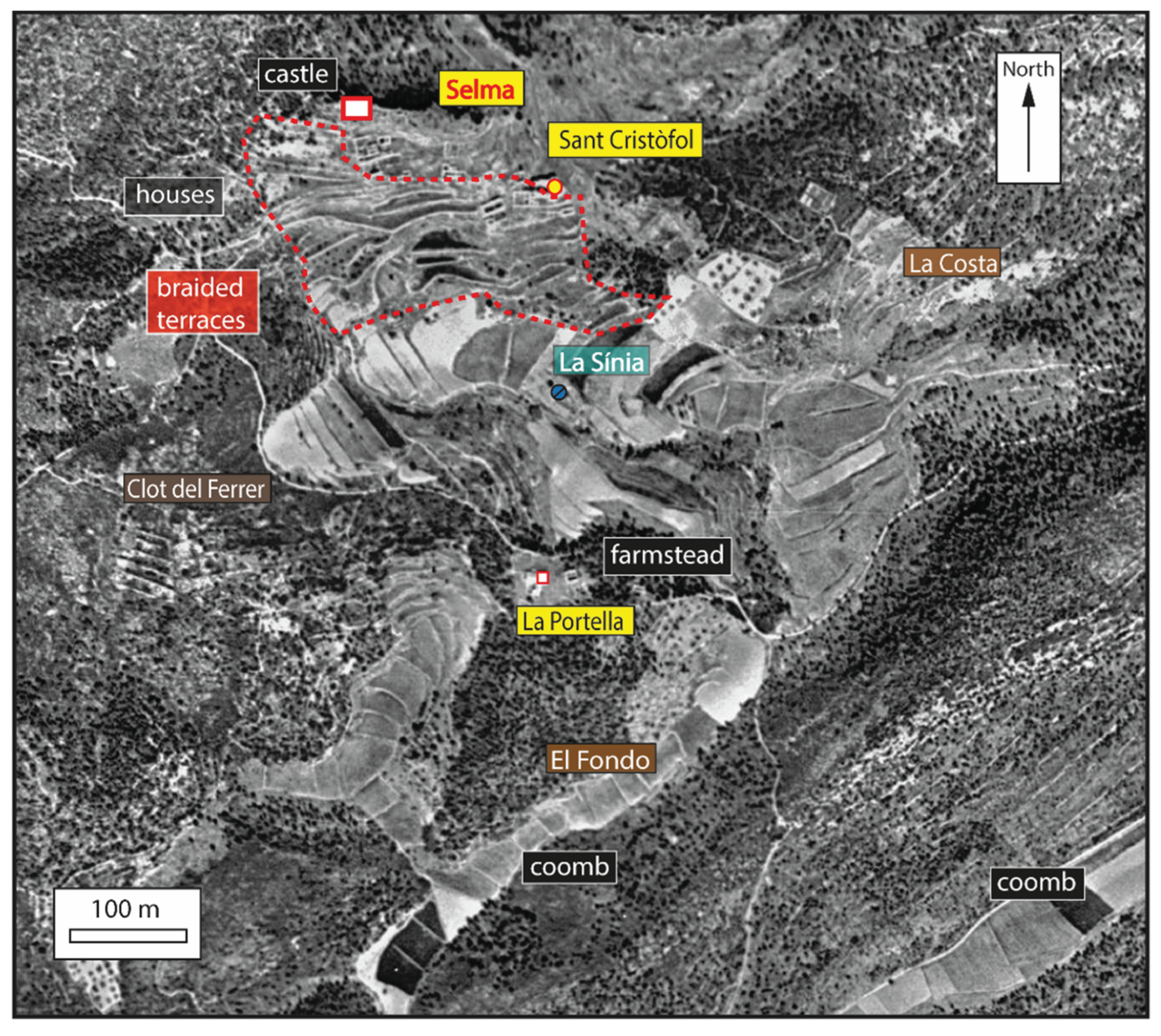
Figure 26.
Pontons (Alt Penedès). Below the castle and the church, numerous braided terraces lie. This site was probably occupied in the 10th century; a document dated 946 mentions cultivated lands, vineyards, and a mill. (Background aerial photography: © ICGC, 1956).
Figure 26.
Pontons (Alt Penedès). Below the castle and the church, numerous braided terraces lie. This site was probably occupied in the 10th century; a document dated 946 mentions cultivated lands, vineyards, and a mill. (Background aerial photography: © ICGC, 1956).
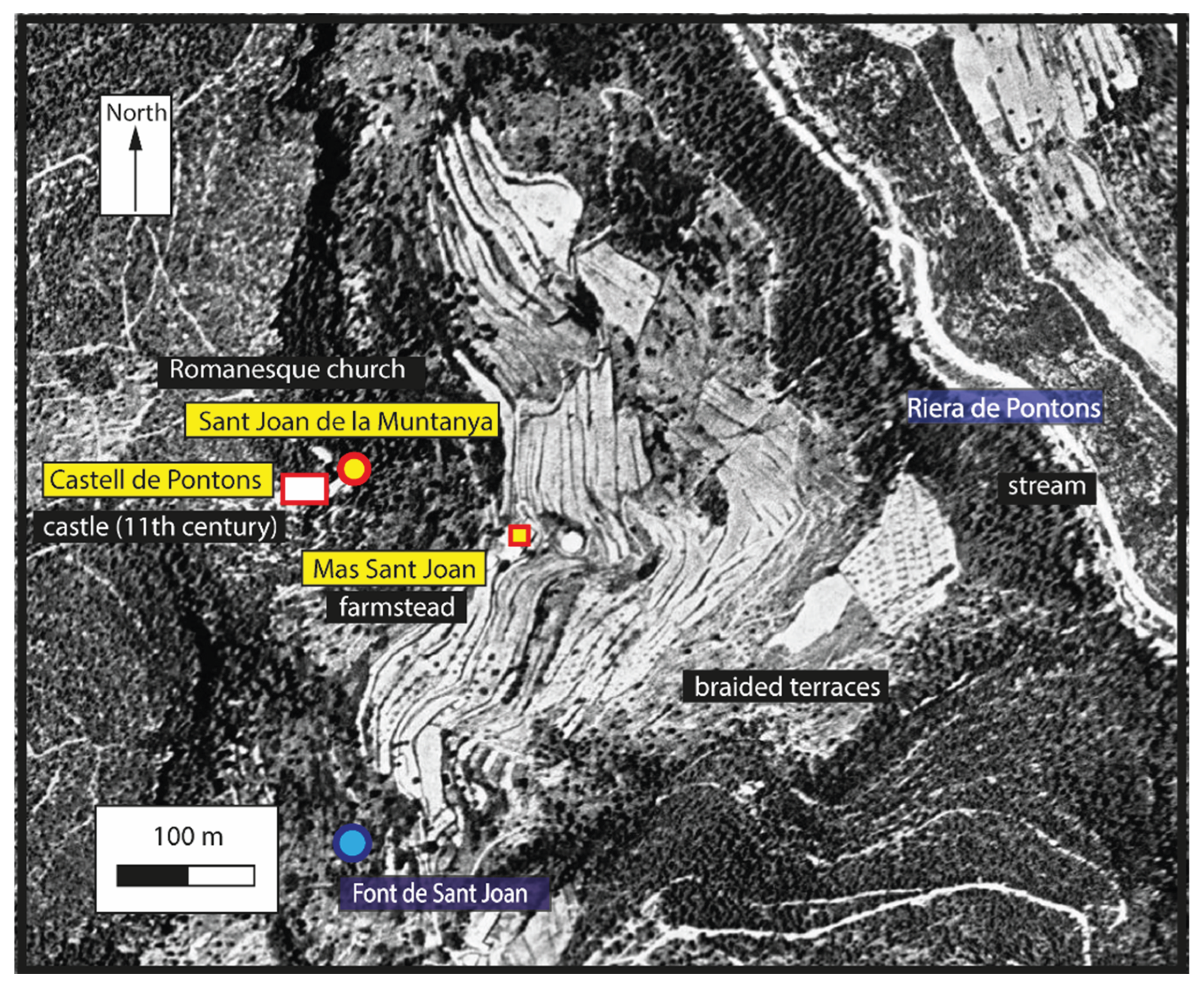
Figure 27.
Various farmsteads located in the northern part of the municipality of Vilassar de Dalt (Maresme). Most of these masos were probably built in the High Middle Ages. In some cases, the rectilinear boundaries of cultivated land coincide with a pre-medieval orientation. (Background aerial photography: © ICGC, 1956).
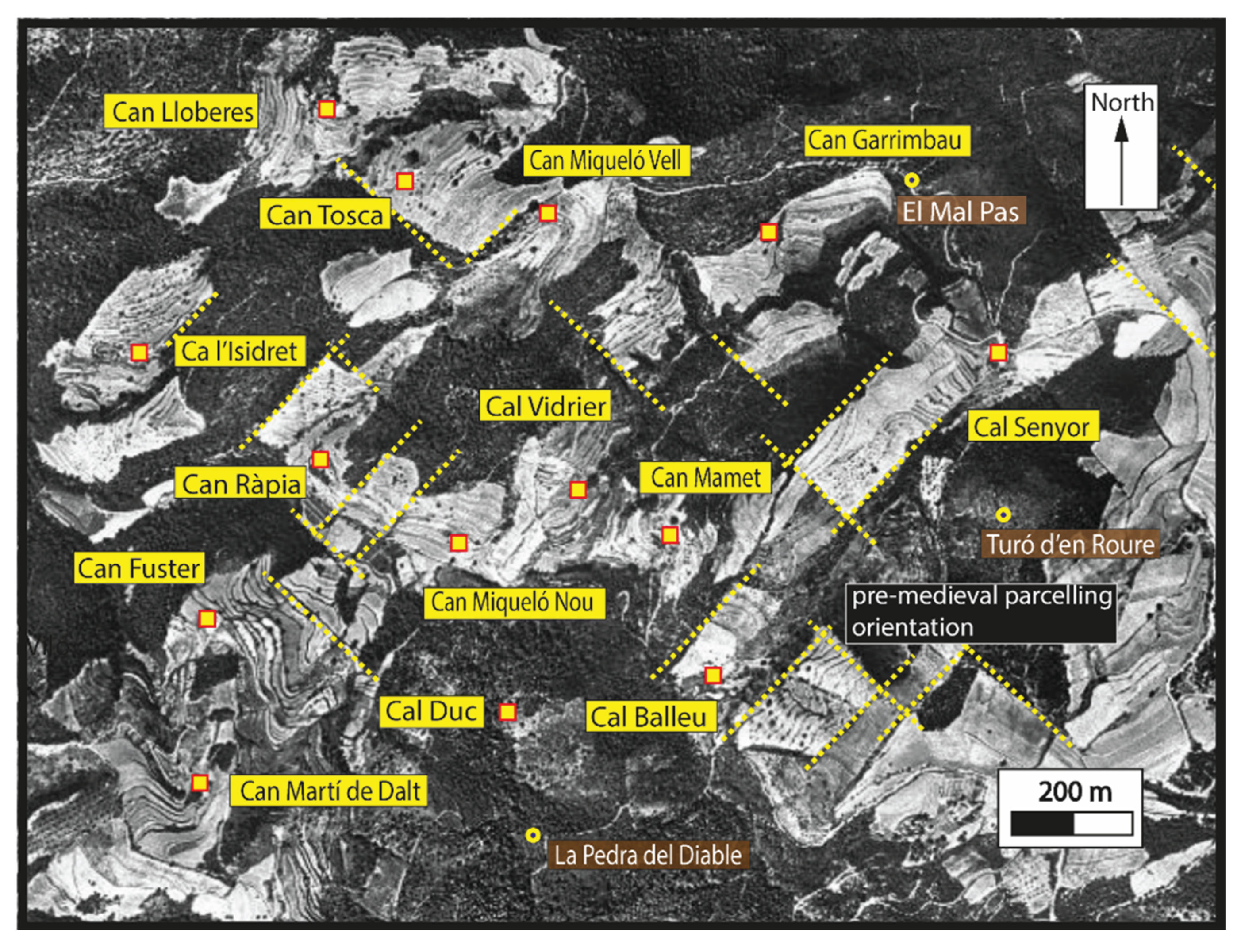
Disclaimer/Publisher’s Note: The statements, opinions and data contained in all publications are solely those of the individual author(s) and contributor(s) and not of MDPI and/or the editor(s). MDPI and/or the editor(s) disclaim responsibility for any injury to people or property resulting from any ideas, methods, instructions or products referred to in the content. |
© 2025 by the authors. Licensee MDPI, Basel, Switzerland. This article is an open access article distributed under the terms and conditions of the Creative Commons Attribution (CC BY) license (http://creativecommons.org/licenses/by/4.0/).
Copyright: This open access article is published under a Creative Commons CC BY 4.0 license, which permit the free download, distribution, and reuse, provided that the author and preprint are cited in any reuse.


