Submitted:
06 July 2023
Posted:
07 July 2023
You are already at the latest version
Abstract
The coombs (in Catalan comes) form an integral part of the landscape. These are small valleys, with the deepest and flattest part cultivated for agriculture. They are predominantly found in the most arid regions of Catalonia, particularly around the cities of Tarragona and Lleida. They are generally dry land areas. We propose that these coombs gained significance in the early centuries of the Middle Ages, a period marked by intense erosion. It is important to identify their locations and establish connections with medieval written documents, the settlements that thrived throughout the Middle Ages, archaeological sites such as necropolises, and the valuable data derived from to-ponymy studies. We think that understanding these coombs can greatly contribute to under-standing how the territory was organized in the Middle Ages, the extent of cultivated lands that were established, and the distribution of many settlements. Ultimately, this knowledge can aid in acquiring better understanding of the current landscape.
Keywords:
landscape
; Middle Age
; Catalonia
; cultivated lands
; settlement
; continuity
; erosion
; aerial photo-graphs
1. Introduction
From the early studies on landscape history, the importance of identifying and dating the various components present in any landscape has been highlighted. When discussing landscape history, one often thinks of the extensive research conducted in England [1,2,3] or France [4,5] over several decades. Recent research in Catalonia allows us to better understand its landscape history and, indirectly, shedding light on the lives of its inhabitants [6,7]. Over the next few pages, the main focus will primarily be on the medieval centuries.
To learn about the past landscape, several sources can be used. Catalonia stands out as one of the European countries with extensive written documentation from the ninth and tenth centuries, known as the Carolingian era. It should be borne in mind, however, that this written documentation only refers to Old Catalonia, encompassing regions located in the north of the country, the Pyrenees, and in the north-eastern areas of Catalonia, north of Barcelona [8,9,10,11,12,13,14]. In addition, these writings do not provide insights into the early medieval centuries, until these lands were conquered by the Carolingians or the ruling counts who governed the different counties. There are still other sources that allow us to understand the history of the landscape. In recent decades, archaeological excavations have been carried out, although some regions have received more attention than others [15,16]. The possibility of better understanding the landscape by studying what has survived to the present day must also be valued. Recent advancements in field work, along with the analysis of maps and aerial photographs have greatly enhanced our knowledge [17]. Additionally, techniques such as pollen analyses [18,19] and optically stimulated luminescence dating (OSL) [20,21] have contributed to our understanding. It is also important to acknowledge the significant contributions made by linguists in the field of toponymy [22]. However, perhaps the most important has been the ability to make use of and connect various sources.
Through these pages, we aim to highlight the interest of discovering and appreciating landscape components that offer substantial information not only into the current landscape but also into the history of a territory and its inhabitants. Specifically, we will explore a component feature known as “coma” in Catalan (also referred to as ‘vall’ or ‘fondo’). This type of farmland has been documented since the Middle Ages and can be linked to frequently inhabited areas during that period. In the following pages we will identify several examples and attempt to determine their dates. We must bear in mind that this particular landscape is primarily found in New Catalonia, although examples can also be found in other regions like Aragon [23,24]. New Catalonia refers to the regions surrounding Lleida, Tarragona and Tortosa, which were mainly conquered by Catalan counts after the year 1000. We must point out that we are fortunate that coombs (comes) are easily distinguishable spaces, such as in aerial photographs, and have remained unchanged over the centuries. This preservation can be attributed to the fact that most of the lands located at the bottom of these coombs are dry land areas.
2. Coombs (comes): Components of the Landscape
2.1. What Is a Coomb (coma) and When Was it Created
In both Europe and Catalonia, previous landscape analyses have focused on specific elements such as churches [25,26], castles [27], or farmhouses [28,29]. Linear elements, such as paths, farmland boundaries, ditches, and even invisible boundaries on the ground [7] have also been examined. Likewise, there have been descriptions and interpretations of extensive landscape components, including irrigated land [30,31], coaxial strips, and terraces [7]. However, our study will concentrate on a specific landscape feature known as comes. This term, derived from the Catalan word coma, corresponds to the French combe or the Occitan comba, which can be translated into English as “coomb”. In Catalonia, comes can be found in the Pyrenees as well as in the more arid lands around Lleida and other regions. These small valleys are scattered throughout the landscape. However, in high mountain lands they often serve as grazing areas for transhumant cattle (such as the Coma de Vaca, located east of Núria, in the Ripollès comarca). In this work, however, our focus will be on the latter type of coombs, which have distinct characteristics compared to the surrounding landscape. We believe that identifying and studying these coombs will enhance our understanding of landscape transformations, especially during the poorly documented centuries of the early Middle Ages.
It must be said that coombs, the small valleys, have existed for millennia. However, we believe that there was a time, specifically in the fifth and sixth centuries, when they were underwent transformations that made them more appealing for human settlements in their vicinity. Studies carried out in other Mediterranean countries have already pointed out significant erosion processes that occurred there. Vita-Finzi focused on lands in North Africa and the wider Mediterranean basin [32]. More recent research has examined the changes that took place along the banks of the Rhone River [33,34]. Scholars have also observed remarkable changes in ground levels that occurred within the Po basin in northern Italy [35]. These erosive processes also existed in Catalonia and contributed, for example, to the growth of the Llobregat delta, which formed during the early medieval centuries in an area that was once covered by the sea during the Roman period [36]. It is worth noting that, to a varying degree, erosive and sedimentation processes occurred in most river basins and valleys across the country, regardless of their size. To understand this, it is also important to bear in mind the insights provided by pollen analyses along the Mediterranean coast, which reflect a stage of deforestation and an increase in the use of land for livestock grazing [7,18].
2.2. Territories and Places Studied
Catalonia is divided into comarques, formed by several municipalities. Later we will discuss specific areas such as Alt Penedès, Conca de Barberà, or Segrià (Figure 1). However, in describing the coombs, we will place them within broader territories. Firstly, we will examine some coombs located in the Penedès region, encompassing the comarques of Alt Penedès and Baix Penedès. Then we will shift southwest and focus on the region of Tarragona, including the Conca de Barberà, and Priorat. Thirdly, we will mention several examples from the Lleida region. Finally, we will approach two comes located in other comarques or regions.
Figure 1.
Map of historical Catalonia. The counties governed by the Generalitat de Catalunya are demarcated. We have identified the sites studied.
Figure 1.
Map of historical Catalonia. The counties governed by the Generalitat de Catalunya are demarcated. We have identified the sites studied.
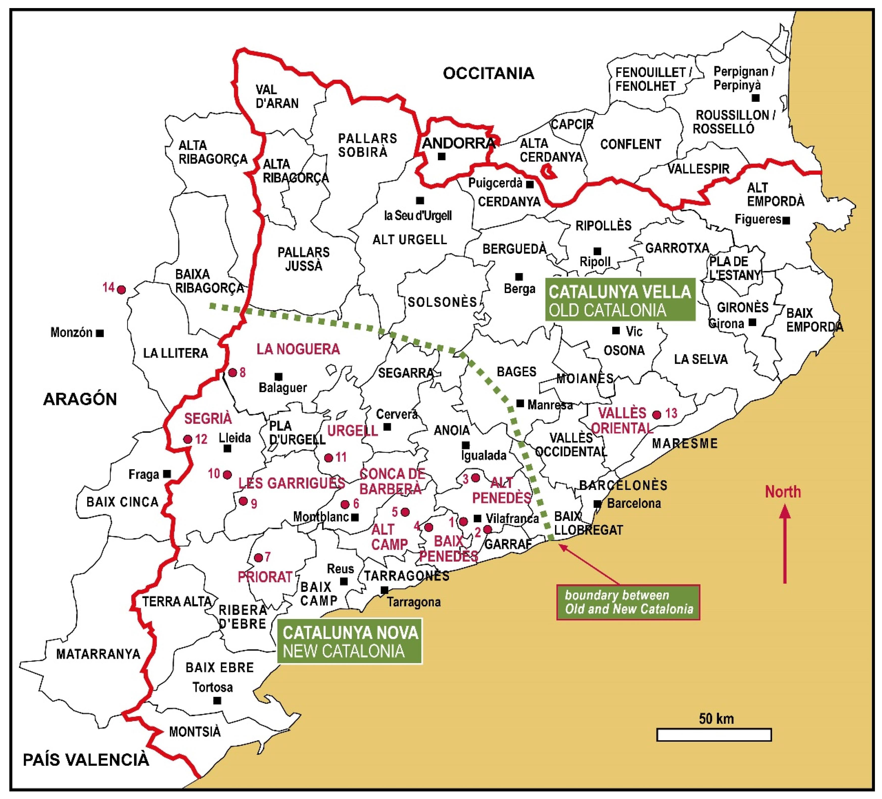
As we have said, understanding the landscape of Catalonia requires consideration of two distinct regions: Old Catalonia and New Catalonia. Old Catalonia basically corresponds to the various counties conquered by the Carolingian Franks, during Charlemagne’s time, extending to the Llobregat River, Cardener River and Montsec Range. New Catalonia includes the regions surrounding the cities of Tarragona, Tortosa and Lleida. During the Middle Ages, there were differences between these two halves of Catalonia, such as the relationship of dependence between peasants and lords [37], as well as variations in settlement characteristics and sizes. In addition, there is a notable difference in rainfall, with irrigation playing a significant role throughout Catalonia, particularly in the arid lands of New Catalonia [31].
In this section, we will explore several examples of coombs, their locations and descriptions. Most of these coombs are located near the cities of Tarragona and Lleida. Later, in the following section, we will relate these cases to what the written sources say, and establish connections between the coombs and other components of the surrounding landscape. Our aim is to gain a better understanding of the coombs’ characteristics and their historical usage.
2.2.1. Penedès Region
The Penedès region extends to the west of Barcelona, ending a few kilometres from Tarragona. In the early Middle Ages, Olèrdola served as its capital. The Carolingian counts gradually conquered the region throughout the ninth and tenth centuries. In 801, the Llobregat River marked the border of the Carolingian Empire, and around the year 1000, the county of Barcelona, which was essentially an independent state, expanded its influence close to Tarragona.
-
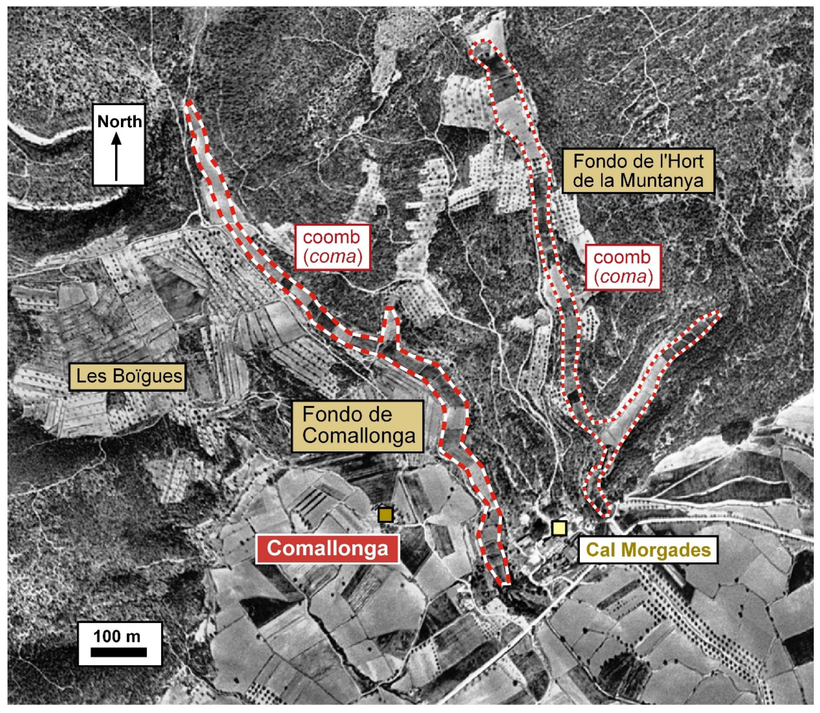
Comallonga (Castellví de la Marca, Alt Penedès) (Figure 2). Comallonga is a coomb, a strip of cultivated land that stretches along a valley floor [38] (pp. 495–540). This particular coomb is 1.16 km long and covers an area of 3 hectares. Notably, there is a 50-m elevation difference between the highest and lowest points. In addition, the coomb is divided into parades (plots of land), with sizes of about 40 meters long and 25 to 35 meters wide (corresponding to the width of the coomb). At the lower end of the coomb, there is a farmstead still known as Comallonga. In the southern sector, flatter lands emerge, where traces of potential fossilized remains from the orthogonal land division during the Roman period can be observed.
-
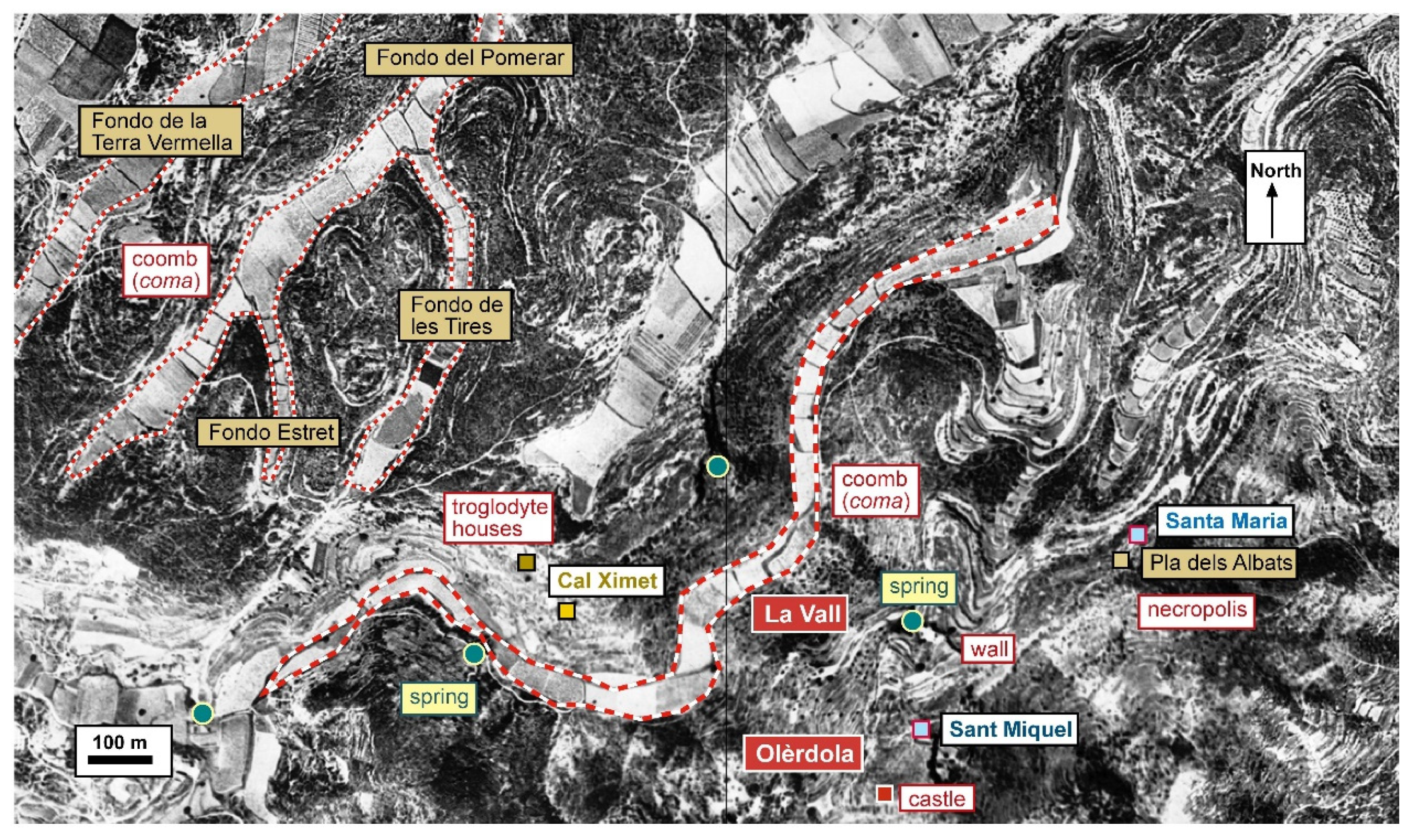
La Vall near Olèrdola (Olèrdola, Alt Penedès) (Figure 3). Next to the Olèrdola site [39], approximately 300 m to the north, lies a coomb known as Fondo de la Vall. It stretches for 2.2 km with a width ranging from 35 to 45 m, covering an area of 7.7 hectares. In close proximity to it are the Balmes de Cal Ximet, which contain remains of a troglodyte habitat dating back to the early Middle Ages [40,41]. On the opposite side of the coomb is a spring called Font de l’Avellaner. Moving further to the north, there are additional coombs, perhaps less fertile extending over approximately 23.7 hectares with a total length of about 4.3 km. These coombs have various names such as Fondo de la Terra Vermella (red earth), Fondo del Pomerar (apple orchard), Fondo Estret (narrow) or Fondo de les Tires (of the strips). Olèrdola is a well-documented place from the tenth century featuring houses, a castle, ancient walls, and several churches.
-
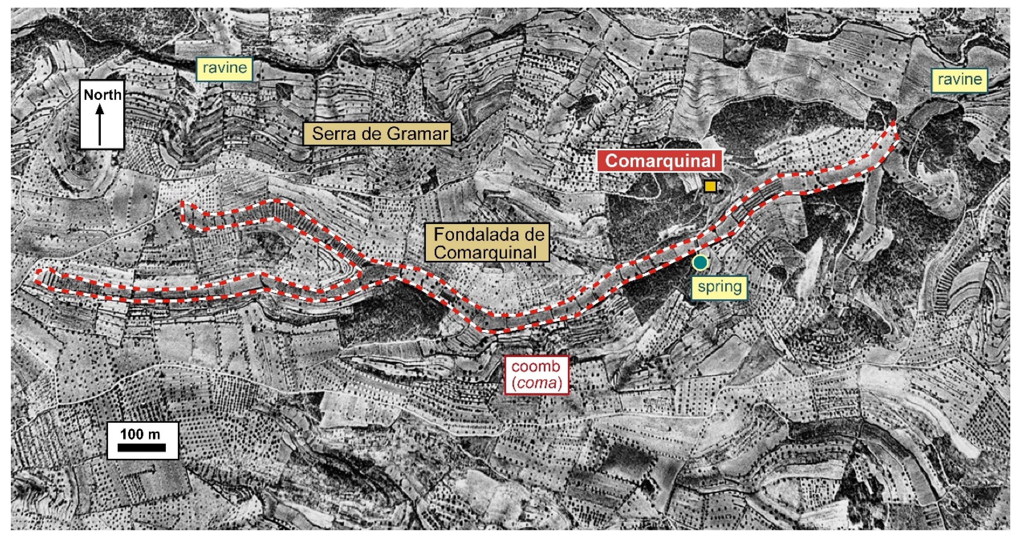
Comarquinal (Sant Quintí de Mediona, Alt Penedès) (Figure 4). Located at the north-eastern end of the Sant Quintí de Mediona municipality, there is a long coomb known as Comarquinal or Fondalada de Comarquinal. It stretches for approximately 2 km, covering an area of 7.0 hectares. On the north side, there is an additional arm of the coomb spanning 1.6 hectares. The western end is situated at an altitude of 383 m, with a height difference of 83 m. The plots of land, known as partides, are about 30 m wide and 60 m long. Notably, the Comarquinal farmhouse is located about 60 m away from the top of the coomb. On the opposite side of the coomb, there is a spring called Font de la Mata. This place name originates from Coma Arquinald, the coomb of a man who likely settled there around the year 1000.
-
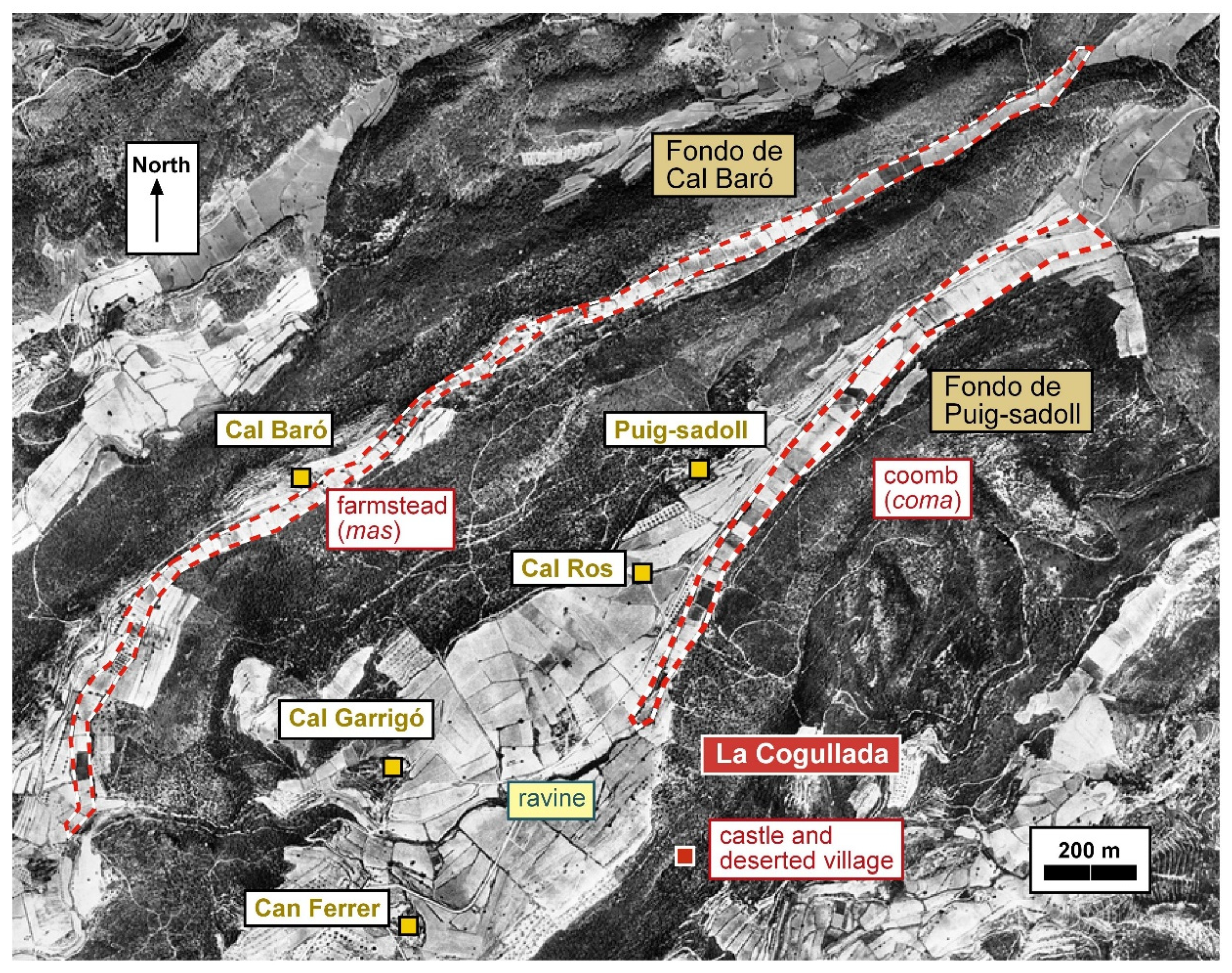
La Cogullada (El Montmell, Baix Penedès) (Figure 5). Adjacent to the Ferrer de la Cogullada farmstead, there is a coomb measuring 1.6 km in length and covering 8.8 hectares [38] (pp. 520–524). There is an elevation difference of approximately 82 m, and it is named Fondo de Puig-sadoll. The Cal Garrigó stream flows nearby. The land within several of the plots, known as parades, has a width of about 40 meters and a length ranging from 25 and 40 m. A little further north, at a distance of approximately 600 m, there is another coomb that is even longer (3 km) and has a larger area (13.3 hectares). In this case, the elevation difference is 184 meters, and it is called Fondo de Cal Baró (located in the municipality of Aiguamúrcia). Currently, these coombs are likely associated with several farmsteads.
2.2.2. Region of Tarragona, Conca de Barberà and Priorat
During the eleventh and twelfth centuries, the Counts of Barcelona, as independent rulers separate from the Frankish kings, gradually conquered New Catalonia. By the end of the tenth century, the border with the Islamic-controlled lands spreads along the Gaià River. Tarragona was definitively conquered in 1116. The Conca de Barberà, situated between the regions of Tarragona and Lleida, was captured during the mid-eleventh century. Moving forward, we will mention some coombs located in the Priorat comarca. The castle of Siurana, located in this region, was not conquered by the Count of Barcelona from the Muslims until 1154. In all these cases, our knowledge is primarily based on documentary references, although many of the coombs may be much older.
-
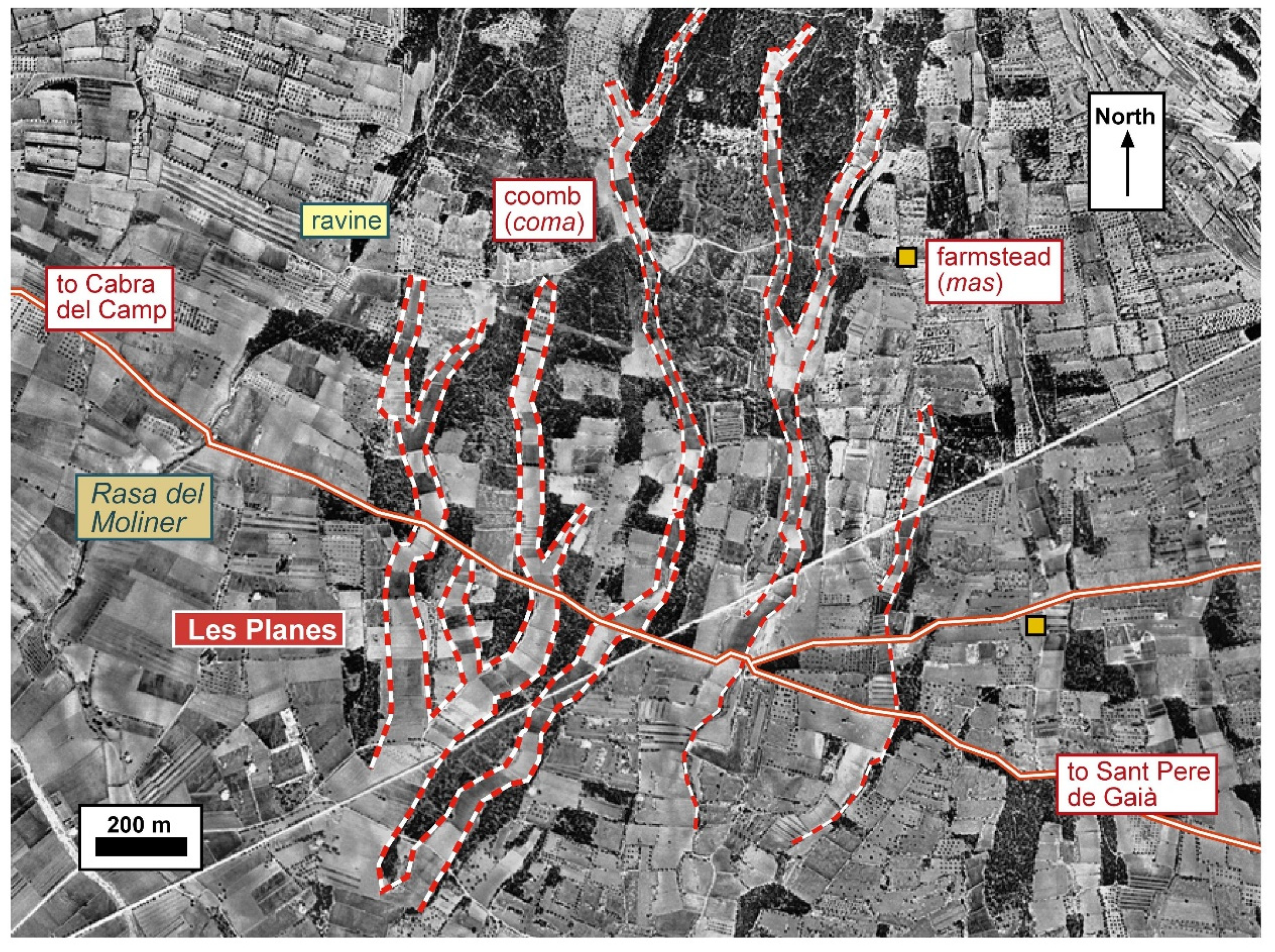
Les Planes (Cabra del Camp and Pla de Santa Maria, Alt Camp) (Figure 6). To the west of the Gaià river, there is a slope furrowed by a path that runs from Sant Pere de Gaià to Cabra del Camp. This road is ancient, existing since at least the Roman period [38] (pp. 781–789). A section of this road aligns with the municipal boundary. On this mountainside, we see at least three coombs that converge at the lower end. The western coomb covers an area of 7.5 hectares, the central coomb also spans approximately 7.5 hectares, the eastern coomb measures 6.0 hectares. Additionally, the southern end extends for about 5.9 more hectares. The total length of the central coomb is approximately 1.6 km, with an elevation difference of about 56 m between the upper and lower ends. The plots of land within this coomb are about 50 to 60 meters long. Currently, scattered farmhouses can be seen on this land, possibly built during the late Middle Ages, along with dispersed livestock enclosures.Figure 6. Aerial photograph of Les Planes (Cabra del Camp and Pla de Santa Maria, Alt Camp), depicting the boundaries of the coombs. The path that connects Sant Pere de Gaià and Cabra del Camp has been marked.Figure 6. Aerial photograph of Les Planes (Cabra del Camp and Pla de Santa Maria, Alt Camp), depicting the boundaries of the coombs. The path that connects Sant Pere de Gaià and Cabra del Camp has been marked.
-
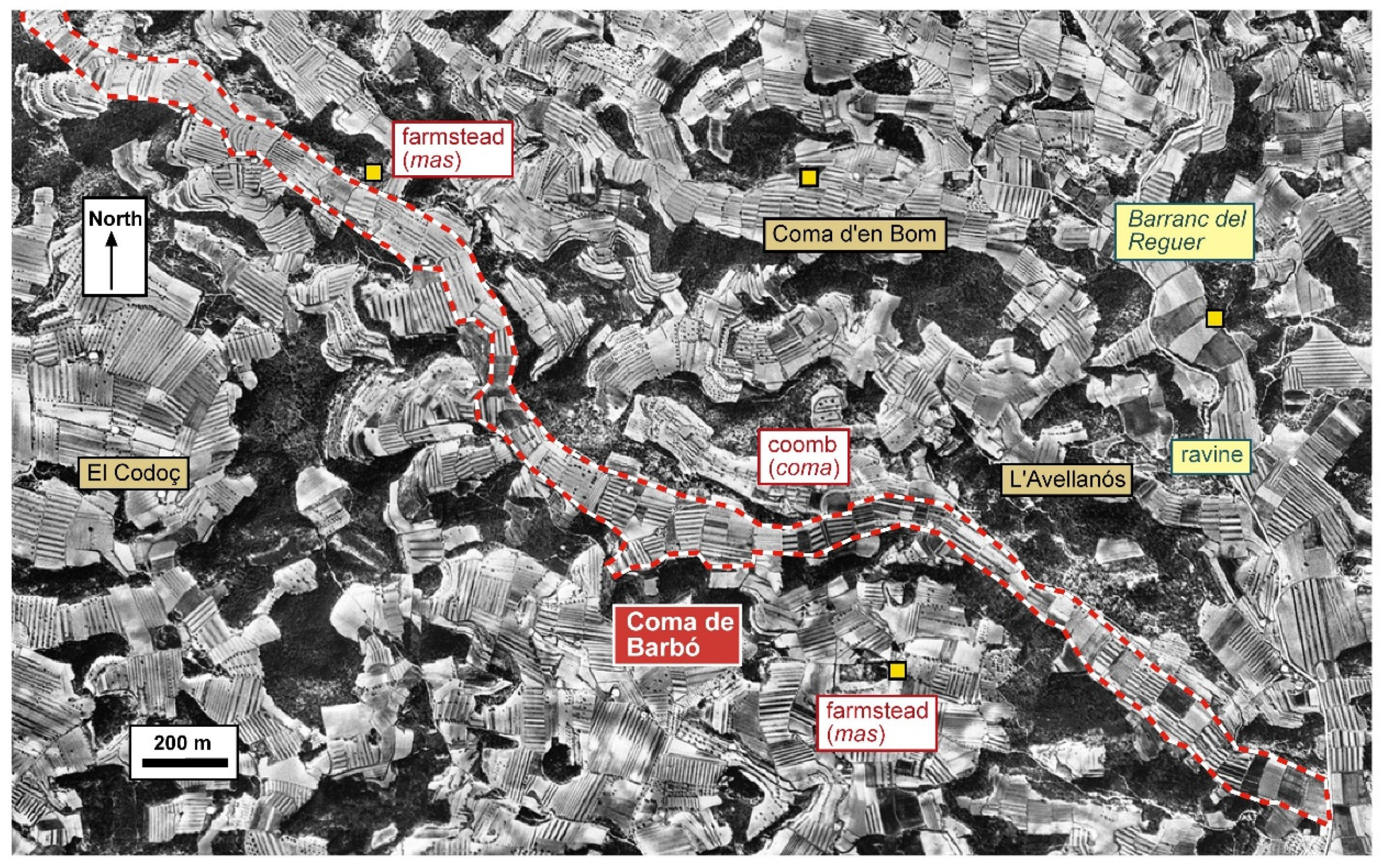
Coma de Barbó (L’Espluga de Francolí, Conca de Barberà) (Figure 7). Located north of L’Espluga de Francolí municipal district, we find Coma de Barbó, one among several coombs in this area. This coomb is notably long, spanning approximately 4.2 km, with a surface area of 38.3 hectares. There is an elevation drop of about 162 meters between the two ends of the coomb, the upper end near L’Argullol, and the lower end at Barranc del Reguer. It has a width of approximately 70 m, and the different plots of land within it range from 40 to 70 m. Nearby, we currently see several scattered farmhouses, possibly created in the later medieval centuries. As we will see, when this territory was conquered around the eleventh century, this coomb and others already existed and were appreciated by the newcomers.
-
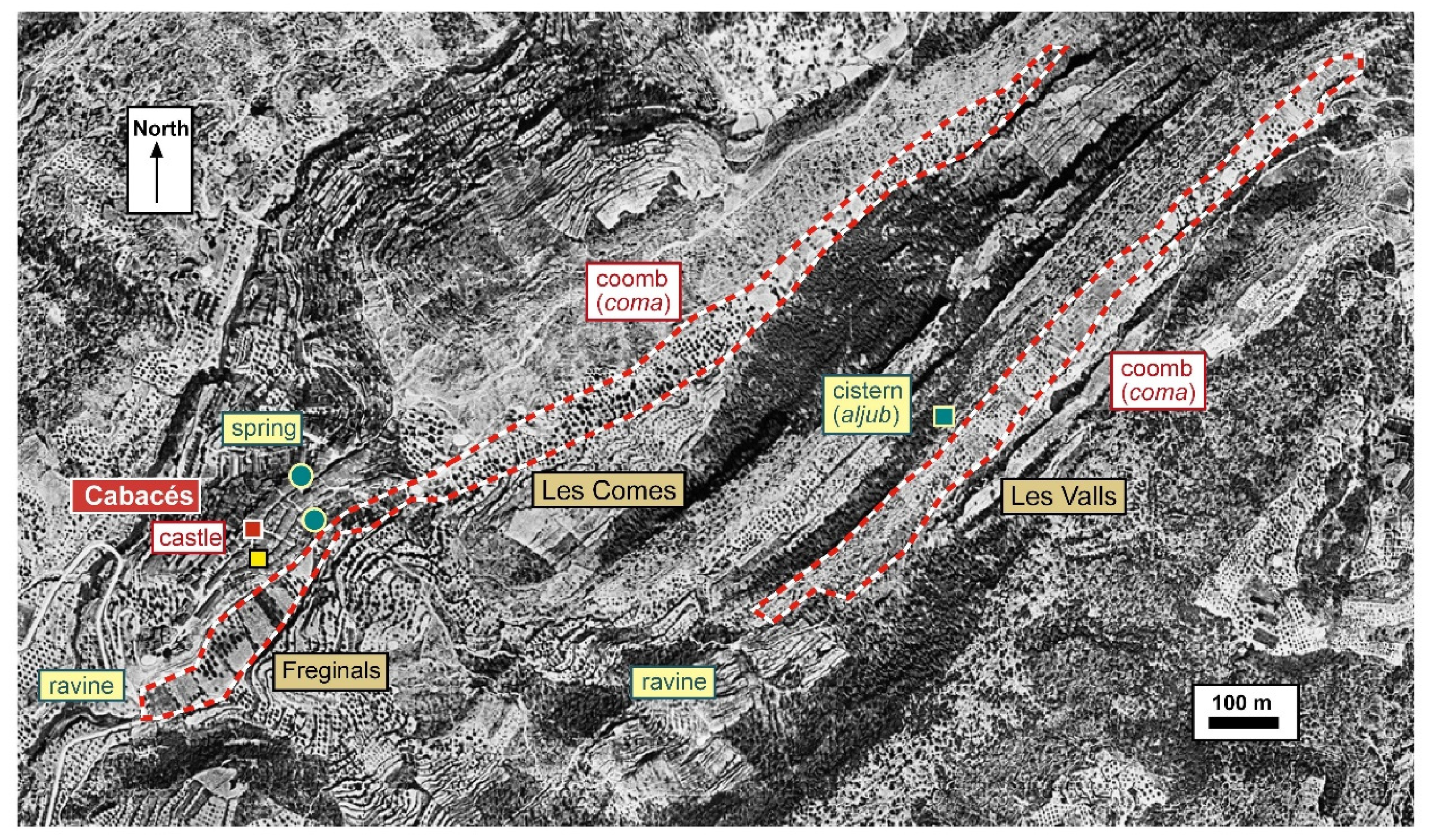
Cabacés (Priorat) (Figure 8). Adjacent to the village of Cabacés is the small valley known as Les Comes. It stretches for 1.7 km next to the village, covering an area of 8.1 hectares with a width of approximately 60 m. The village was built after the county’s conquest, next to a castle. However, it certainly existed long before that. The earliest preserved documents mention Abincabacer, which reveals both an Arabic and a Mozarabic name [22] (vol. 3, p. 158). About 350 m further east, there is another coomb called Les Valls, which measures 1 kilometer in length and occupies an area of 3.7 hectares.
2.2.3. Region of Lleida
The city of Lleida was not conquered by Count Ramon Berenguer IV of Barcelona and Count Ermengol VI of Urgell until 1149 [42,43]. The transformations that took place during the years of Islamic rule were significant, particularly in comparison to Old Catalonia. Throughout the tenth and eleventh centuries, large ditches were constructed primarily in the cities of Lleida and Balaguer. However, this does not negate the presence of elements in the landscape predating the Islamic era. It should be understood that the process of Islamization, like in most places, was gradual and did not conclude until around the year 1000 [44].
-
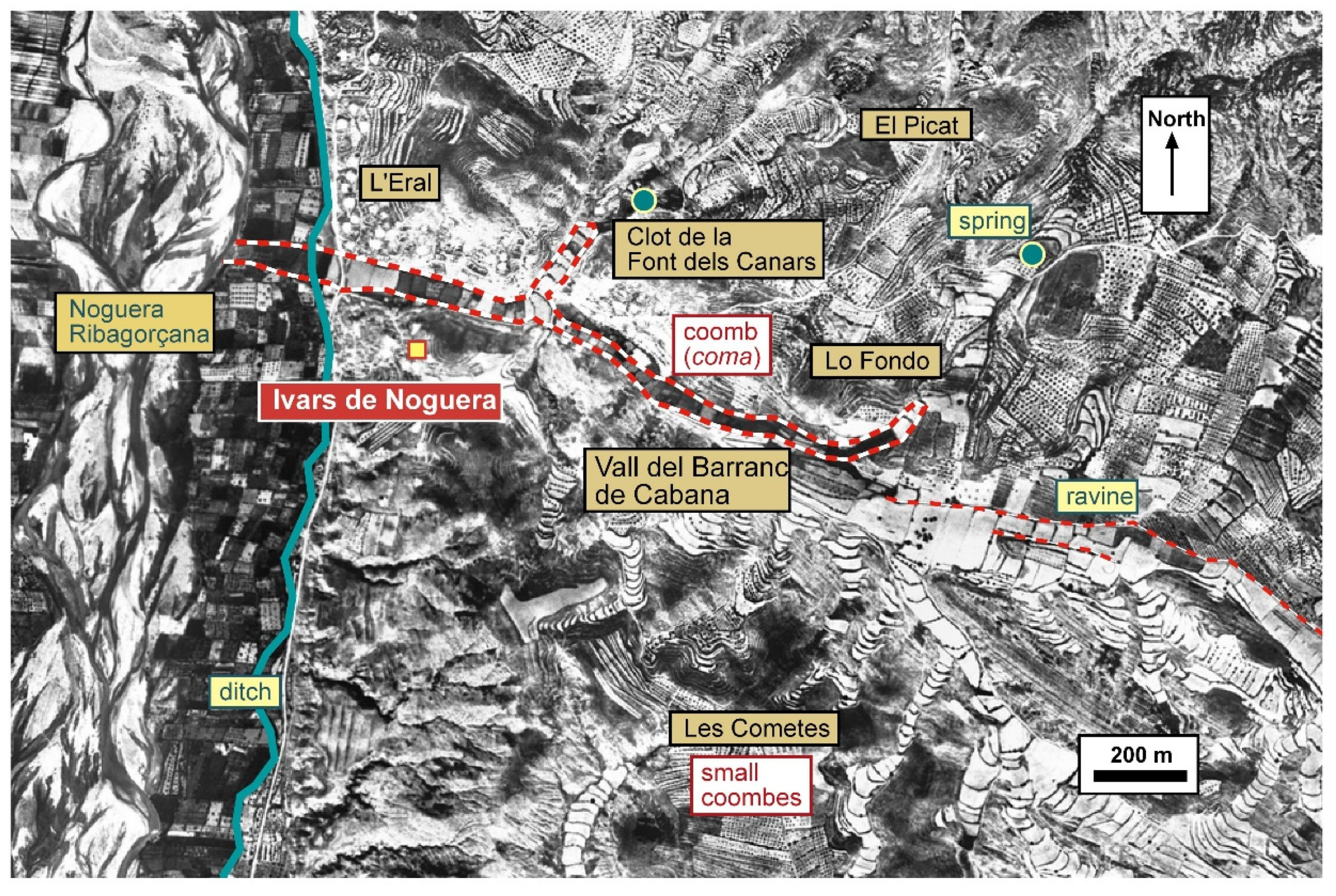
Ivars de Noguera (La Noguera) (Figure 9). To the north of the village, there is a coomb known as Vall del Barranc de Cabana [45]. It stretches for 1.8 km and covers an area of 9.8 hectares. Additionally, there is a branch extending northward, spanning 1.1 hectares. In the westernmost sector, below the town and closer to the Noguera Ribagorçana river, the width is greater (approximately 50 meters), suggesting that it may have been used for irrigation purposes. The plots of land within this coomb are about 40 meters long. Moving eastward, the coomb becomes narrower (around 30 m). The elevation difference in level is not significant, with approximately 62 m between the eastern end and the river.
-
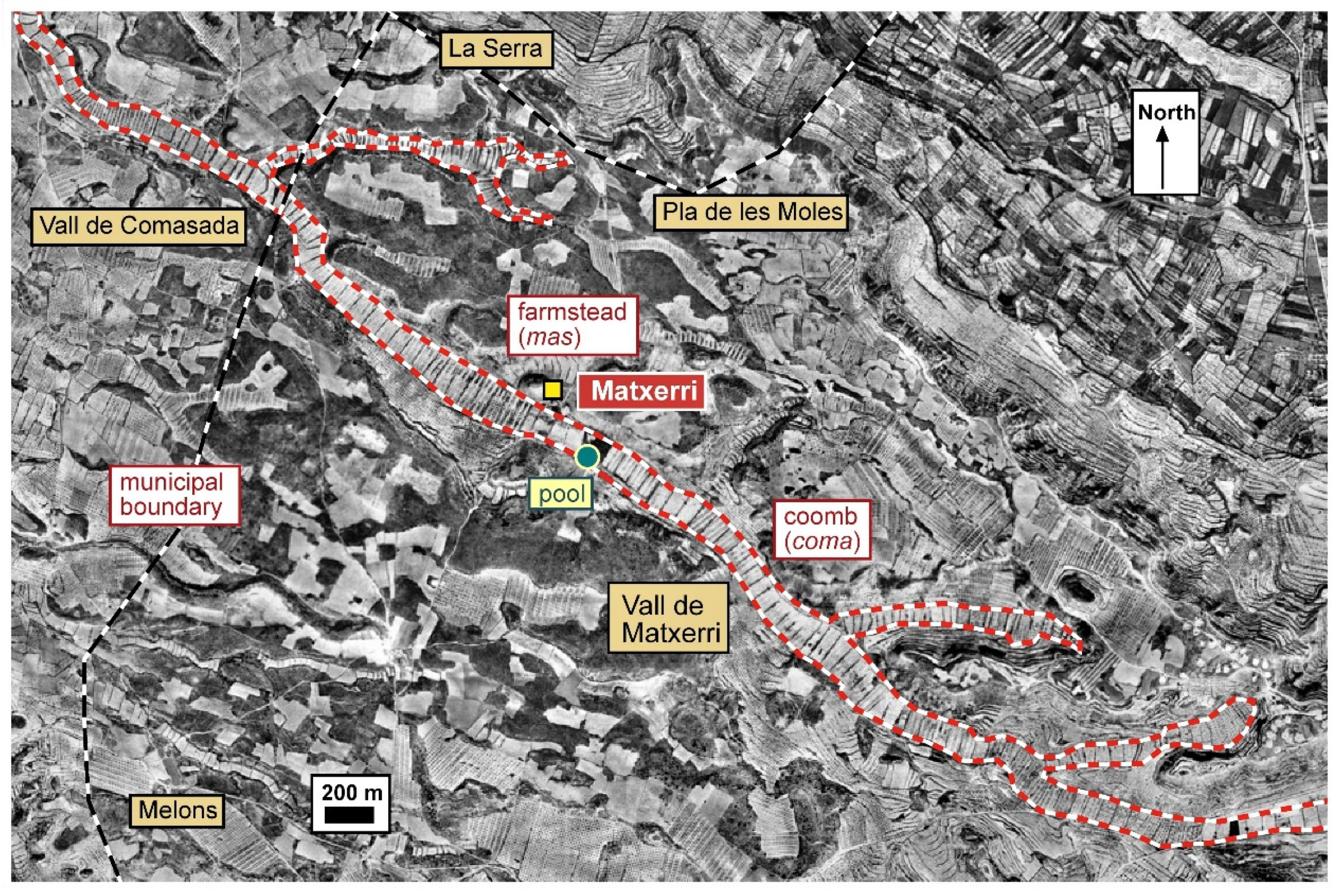
Matxerri (Castelldans, Garrigues) (Figure 10). To the west of Castelldans lies the Mas de Matxerri [7]. Below the farmhouse, there is a wide coomb that stretches for 5.8 km from the municipal boundary in the west to the outskirts of Castelldans. It covers an area of 79.1 hectares. If we continue west into the current municipal districts of Artesa de Lleida, it extends another 4.8 km with an additional 40.8 hectares. The total difference in elevation is 133 m (81 m within the municipality of Castelldans alone). The coomb’s width is approximately 110 m, and the plots of land are about 70 m long. It should be noted that the terrain is arid. Next to the Mas de Matxerri, there is a water pool. While the coomb within the area of Castelldans is called Vall de Matxerri, in the western sector, it is known as Comasada. It should be noted that about 2 km south of the Matxerri valley, there is the Melons valley, a very long coomb spanning over 9 km. The names "sada" and "melons" both have Latin origins, referring to cultivated places and locations where badgers were found [22] (vol. 6, p 464; vol. 5, p. 247). This linguistic fact is not only of interest but also suggests continuity in population and the use of these valleys since at least the end of the Roman era.
-
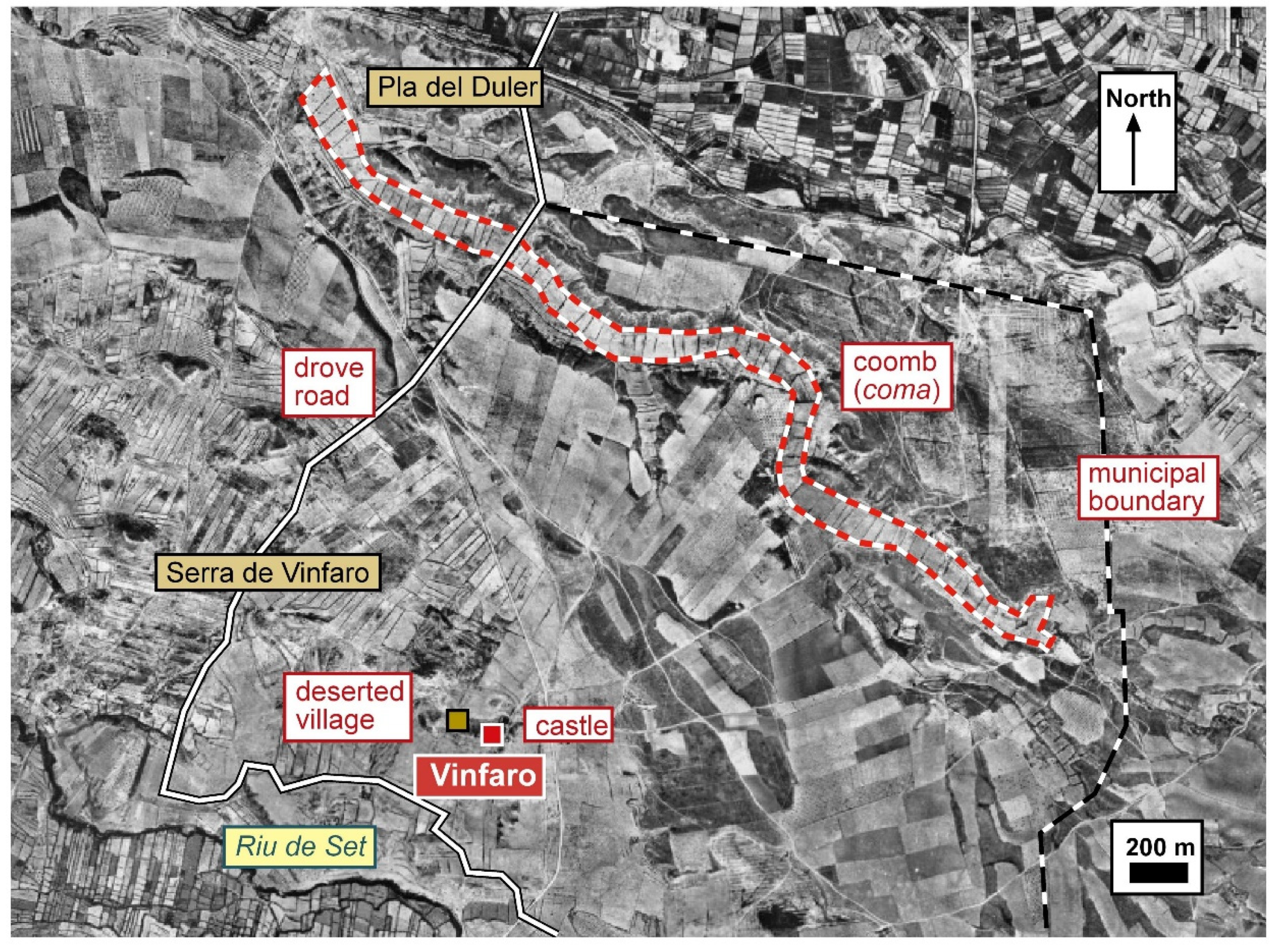
Vinfaro (Alfés, Segrià) (Figure 11). To the north of the Vinfaro district, a medieval village that was abandoned in modern times, there is a wide coomb extending for 2.8 km within the municipality. It covers an area of 27.8 hectares of dry land with a slight difference in elevation of approximately 26 m. The coomb’s width is 100 m, and the plots of land, without stone borders, range in length from 40 to 60 m. To the south, near the Riu de Set River, there is another smaller coomb. The Vinfaro district was primarily dry land and the rearing of cattle must have been significant, as evidenced by the presence of a drove road and the place name Pla del Duler (the duler was the shepherd in charge of the dula or herd of grazing animals).
-
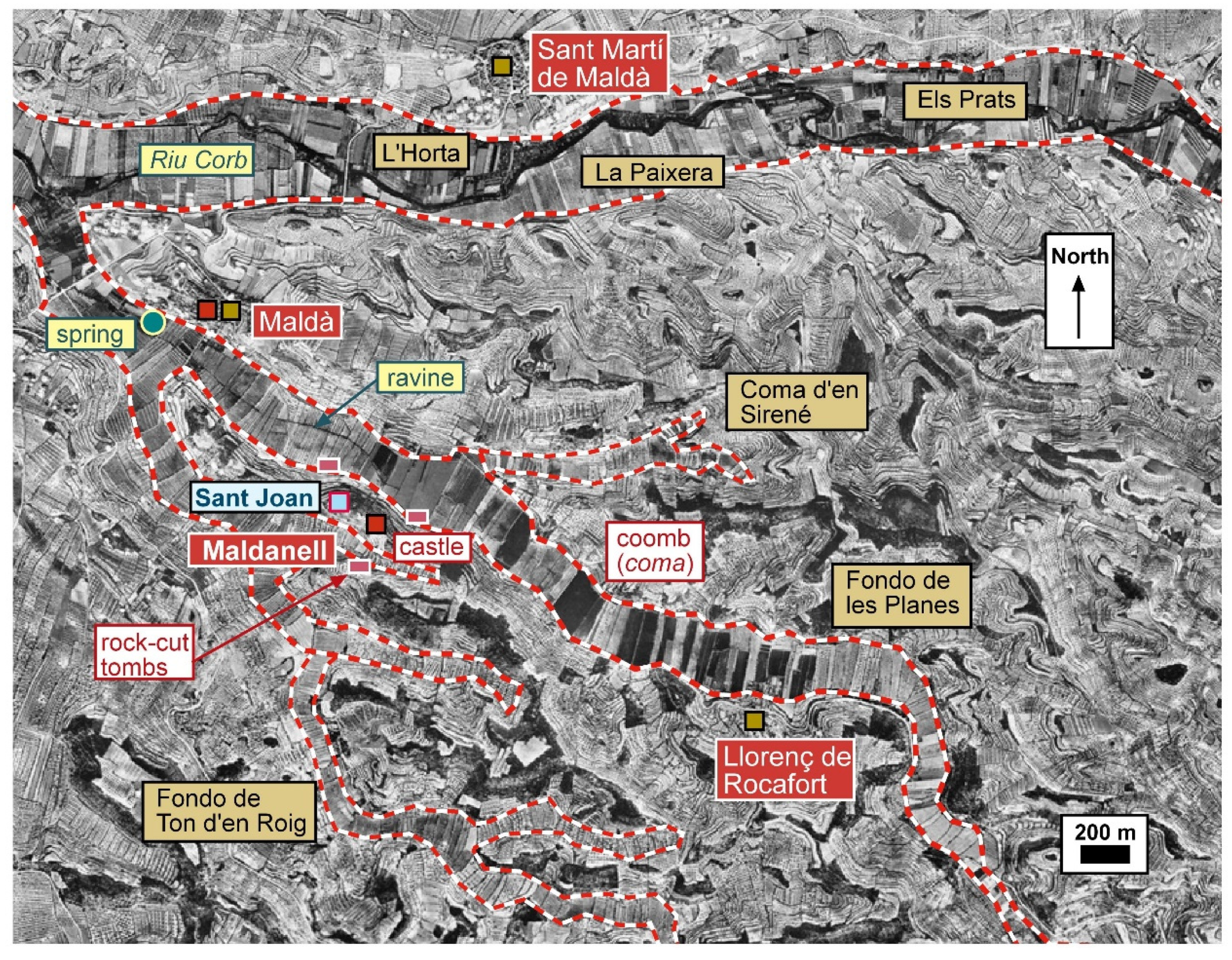
Maldanell (Maldà, Urgell) (Figure 12). In the municipality of Maldà, there was a castle and a settlement known as Maldanell, or “little Maldà”. Below Maldanell is a small watercourse and a very extensive coma, referred to as Fondo de les Planes [46] (p. 97) in certain areas. It stretches for 5.2 km, with a difference in elevation of 82 m. The total area is approximately 104 hectares although it is unclear whether this resulted from expansions. This coomb is wider and more fertile than the previously mentioned ones. The land plots are estimated to be about 170 m in width, corresponding to the coomb’s width, but they are not very long, ranging from 30 to 60 m. It should be noted that further north, between Maldà and Sant Martí de Maldà, the Riu Corb can be found. On both riverbanks, there is a cultivated area, in some cases irrigated, which is quite reminiscent of what we see in some places, such as that of Maldanell. The space close to the river in this case of the Riu Corb has a width that oscillates between 350 and 450 m.
-
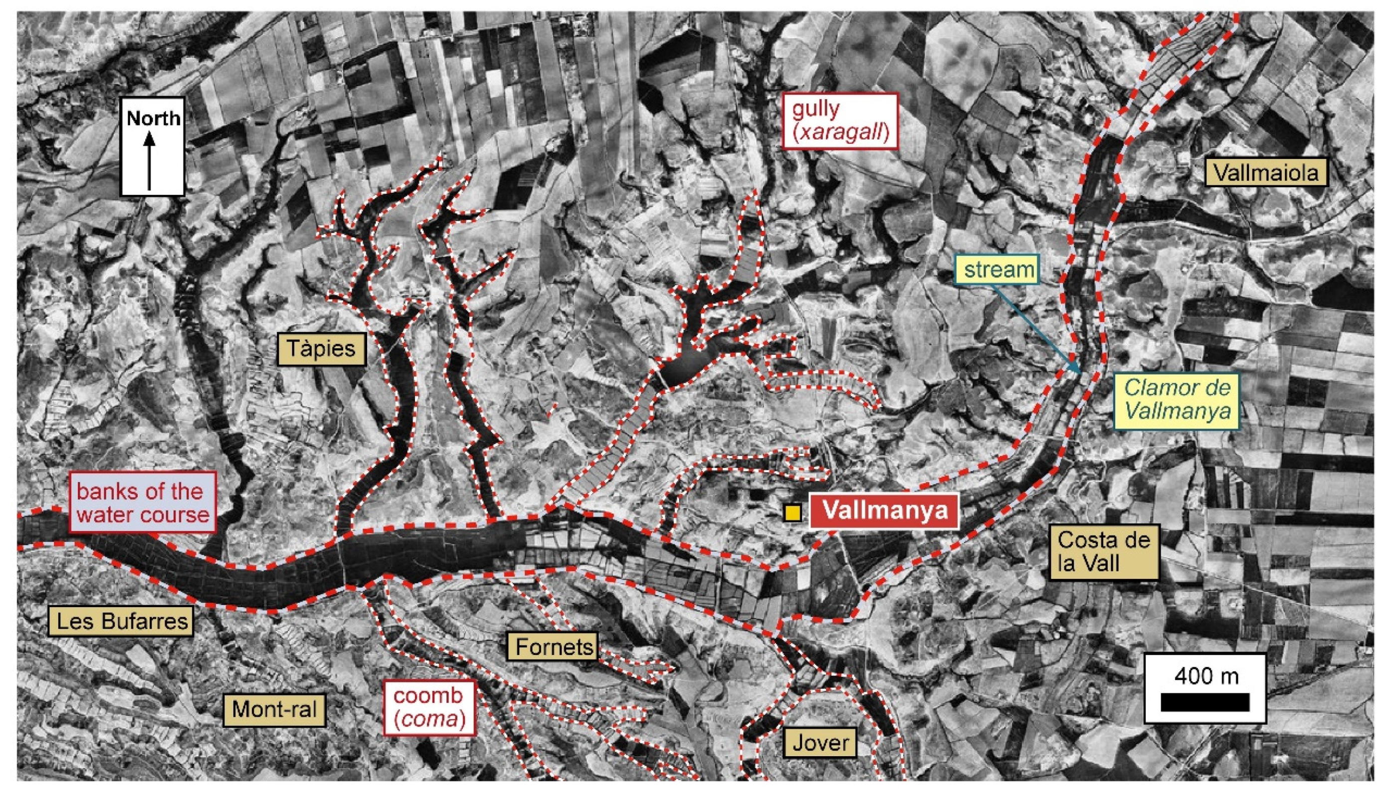
Vallmanya (Alcarràs, Segrià) (Figure 13). To the west of the Segrià region lies the Clamor de Vallmanya. It spans 8.6 km, stretching between the district of Raimat (municipality of Lleida) and the municipality de Saidí (near Fraga, Aragon). On both sides of the clamor we see cultivated land divided into parcels, which is more fertile. The total width of this area is about 160 m, covering nearly 150 hectares of cultivated land. However, when the aerial photographs were taken, in the mid-20th century, significant changes had already been made to the area due to rezoning. The difference in elevation, from one end of the clamor to the other is 80 m. Along the banks of the clamor, we see several coombs extending to the north and south. To the north, there are at least six and to the south and east, there are six more, some with branching formations. The key difference between a river and a clamor is that the latter typically carries very little water, usually only during stormy periods when it generates a a loud noise (referred to as clamor in Catalan).Figure 13. Aerial photograph of Vallmanya (Alcarràs, Segrià). The boundaries of the lands closest to the course of the clamor and the coombs boundaries have been represented.Figure 13. Aerial photograph of Vallmanya (Alcarràs, Segrià). The boundaries of the lands closest to the course of the clamor and the coombs boundaries have been represented.
2.2.4. Other Regions
Finally, we will examine two additional cases. One located in the region known as Old Catalonia, a territory conquered by the Carolingian Franks around the year 801. However, what we observe has much older origins, which we will delve into in the second part of this study. The second case takes us to a space with different characteristics, the territory of Fonz in Aragon. Christian documents already mention Fonz in the second half of the eleventh century, and Christian rule was consolidated in the twelfth century.
-
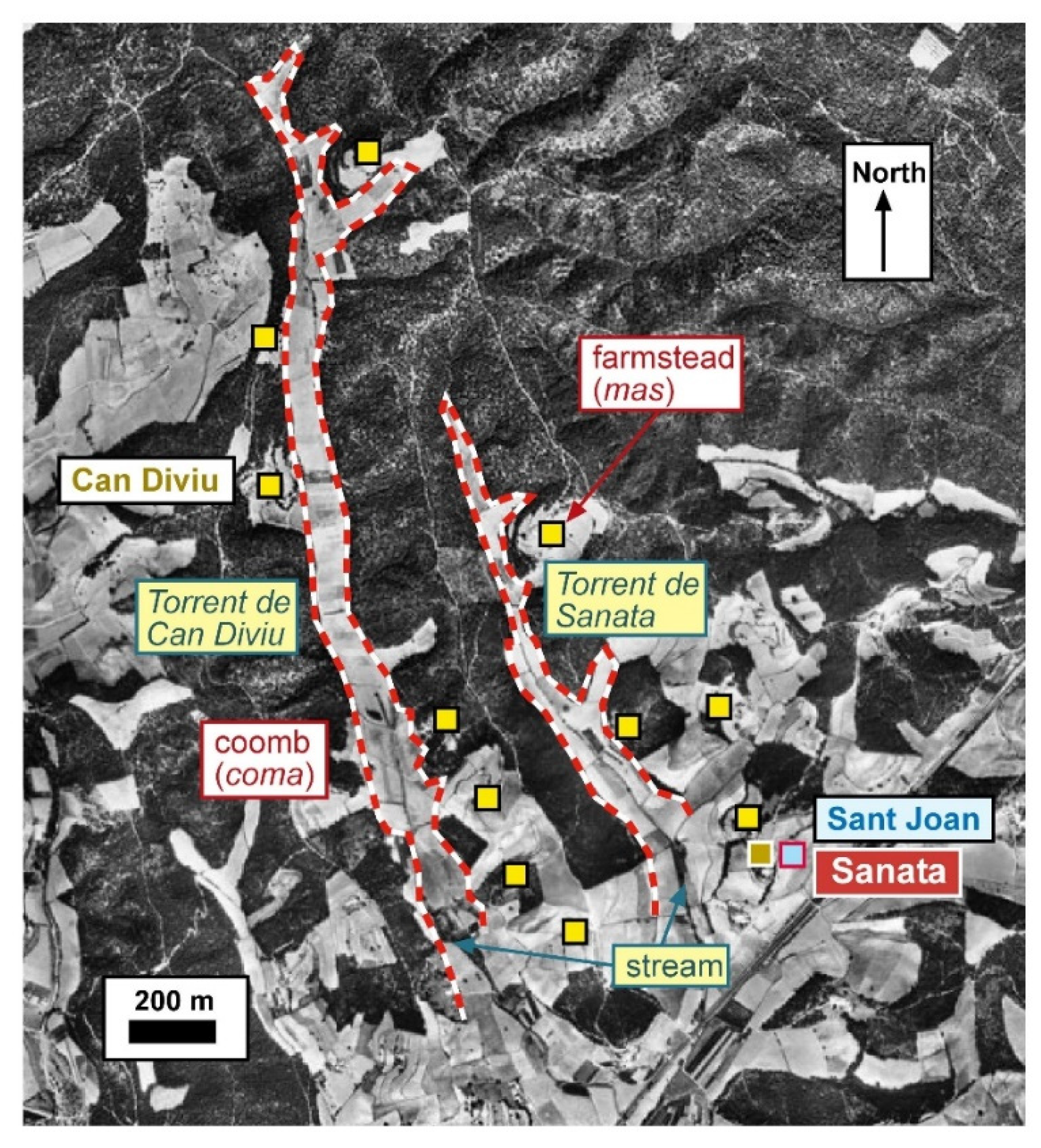
Sanata (Llinars del Vallès, Vallès Oriental) (Figure 14). Located north of the Via Augusta (road that in Roman times joined Barcelona and Girona) and at the foot of the Montseny mountain range, we find several coombs [38] (pp. 498–503). One of these coombs is furrowed by the Torrent de Can Diviu. It stretches for 2.3 km and covers a cultivated area of 23.6 hectares. Its width is approximately 85 m, and the elevation difference is relatively gentle compared to other cases, only about 48 m. Interestingly, there are no stone borders separating the various plots of land within this coomb. To the east of this coomb, there is another smaller one, which extends along the Torrent de Sanata. It spans about 1.2 km with an area of approximately 8 hectares. In this territory, numerous farmsteads are located not within the coomb itself but on its sides, each with its own circle of fields. The area is wooded.
-
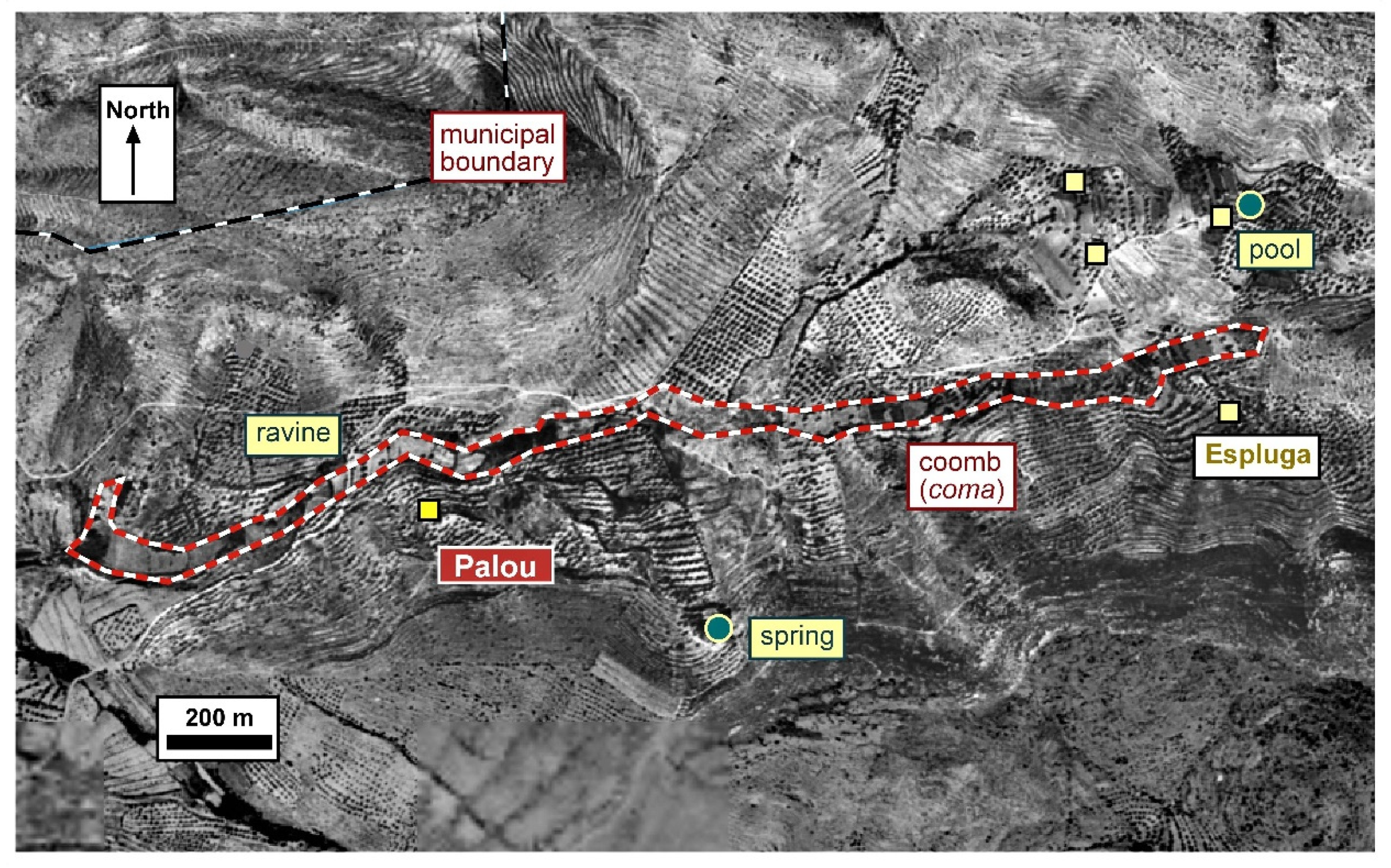
Palou (Fonz, Aragon) (Figure 15). Situated around 3 km from the town of Fonz (known as Fonts in the Middle Ages when Catalan was spoken there), we find the small valley of Palou. It stretches for 2.1 km and covers an area of about 9.7 hectares [47]. The elevation difference in this valley is about 100 m, and its width is about 40 m. The plots of land within it range from 40 to 60 m in length. As we will discuss later, Palou is a fascinating place because its name, derived from the Latin palatiolum, possibly predates the Christian conquest and subsequent repopulation.
3. Relate the Sources to Understand the Historic Landscape
In the previous section we described the characteristics of coombs and introduced a series of places, where we find lands exhibiting these features. These areas, although sometimes referred to as comes, valls (valleys) or fondos (deep places), can be defined as coombs. Next, we will attempt to date all these coombs by examining written documents and establishing connections with other nearby landscape elements, such as inhabited areas or ditches. We will also emphasize the importance of toponymy as a valuable source that can provide insights into the history of a territory, including the continuity of its population.
3.1. What Do the Written Documents reveal?
In a document written between the years 960 and 985, the place of Comallonga (Chomalonga) is mentioned [13] (doc. 852). It served as one of the boundaries of the castle district of Castellví de la Marca [48] (p. 105) which, as the name implies, was a castle located at the border (marca) of the county of Barcelona. This document is important because it already refers to a long coomb, a characteristic coomb that can still be observed in aerial photographs. It provides evidence of this reality before the year 1000. However, as we will explore, we believe that many of these coombs have even older origins. It should also be noted that they may have been developed over the course of the Middle Ages.
In Les Planes (Figure 6), as previously mentioned, there are several coombs located alongside the path connecting Sant Pere de Gaià and Cabra del Camp. These coombs follow the natural slope of the mountainside. A significant document related to this area dates back to 1193 [49] (doc. 361). It is an agreement between the abbot of Santes Creus and the archbishop of Tarragona. The document refers to the new works (novam laborationem) to be carried out in the minor coomb (minori cumba) which is located near the larger coomb (maiorem et prolixiorem cumbam). It is known that cereals, vineyards and olive trees were cultivated in these coombs. Additionally, the text mentions the Coma de Gasc (cumba de Gasc). This text not only mentions the existence of these coombs but also suggests ongoing efforts, possibly to expand them.
One last example, in relation to Coma de Barbó (Figure 7). In a land terrier from 1558 the Cavalleria de la Coma de Borbó (or Barbó) is mentioned [50]. A cavalleria refers to a knight’s fief, established during the 11th or 12th centuries, when these lands were conquered by the Count of Barcelona. It should be noted that the creation of this feudal cavalleria involved granting lands within a coomb, which obviously existed before the arrival of the Count of Barcelona and, most probably, even before the arrival of the Islamic armies. This example demonstrates the value placed on these lands.
3.2. The Significance of Place Names
Place names can often provide valuable information indirectly. They can describe the features of a location and indicate the time of their origin. We especially valued the fact that a long coomb called Comallonga was mentioned prior to the year 1000 and can now be located on the ground in aerial photographs. Another interesting example is found in a document from 1011 [51] (doc. 100) that mentions the boundaries of the village of Sant Pere de Riudebitlles. At the northern end of the village was the Comarquinal. The document provides a detailed description of the boundaries, mentioning everything that would have been found along the site’s border. In the north, it is noteworthy that the spring of Arquinald (now Font de la Mata) and of the coomb of Comarquinal (cumbam de Archinallo) are mentioned. The boundary then continued towards the cumbam de Lenario, which we believe corresponds to the valley of the Gramar stream, a coomb that is currently irrigated.
Toponymy, the study of place names, is often crucial for understanding the history of places. In the region of Lleida, there are several coombs that can be related to place names that existed before the year 1149, when the Count of Barcelona conquered the area. These are just a few examples we have already mentioned. The site of Matxerri is particularly interesting. We could comment on its characteristics as an Islamic settlement [52]. However, our current focus is on the origin of the name Matxerri, which appears to derive from the Latin word macĕrĭes, suggesting the presence of rammed earth walls or masonry walls [22] (vol. 5, p. 238) at this location. This name was probably used by the Mozarab communities that lived there. It is necessary to bear in mind the link between the inhabited place and the cultivated lands of the coomb. In relation to the same region, we should also remember the toponyms Comasada or Melons [22] (vol. 6, p. 464; vol. 5, p. 247), which we mentioned earlier, and must be as old as Matxerri. A similar situation exists with Vinfaro and the coomb located 1.5 km further north. Vinfaro derives from the Arabic name Ibn Hārūn [22] (vol. 8, p. 71). It is also worth noting the importance of cattle breeding in these regions, leading us to envision a landscape that existed before the 12th century and perhaps even before the 8th century.
Toponymy studies sometimes reveal surprising information. For instance, Sanata, in the Vallès Oriental comarca, bears a Berber name. A Berber community settled in this mountainous area next to the Via Augusta, between Barcelona and Girona, probably shortly before the year 720. As we have seen, there are several coombs in this place,. One of them is the coma of the Sanata stream, and nearby is a larger one, the stream of Can Diviu comb, possibly derived from nabiu, the Vaccinium myrtillus). It is highly likely that this Berber community from the Zenata tribe settled in this place due to its strategic position and the presence of a cultivated coomb. Despite being fertile, the land was not irrigated [38] (p. 497).
One last comment remains. The site of Palou is located east of the Cinca river, in a region where Catalan was spoken during the high Middle Ages [47]. As noted, the name Palou is derived from the Latin palatiolum. Initially, we attempted to associate palaces (palatia) and small palaces (palatiola) with institutions created in the Islamic era. However, it is more logical to consider Palou as a fiscal institution from the late Roman world, later utilized by the Muslims [38] (p. 330). This leads us believe that the coomb landscape may date back to the same period. In this case, it seems that the Mozarab population (for example in the Islamic era) called this place Palazuelo, while the Catalan-speaking settlers subsequently named it with the Catalan name Palou, a name it still carries today (despite Catalan no longer being spoken there) [47] (doc. 106).
Furthermore, we can point out that, although the term “coomb” has been lost in many places, we occasionally encounter its name fossilised in some place names (such as Comallonga, Camarquinal, Comasada, Coma de Barbó) or in relation to groups of fields, such as Les Comes (Cabacés). Additionally, we sometimes find references to La Vall or Les Valls, also probably ancient forms with the same meaning.
3.3. Hamlets and Villages
As can be seen from the statements made in the previous paragraphs, establishing a connection between these coombs and inhabited places throughout the Middle Ages is crucial. We believe that the cultivated coombs emerged during the transitional phase between the Roman and medieval periods (while not ruling out the possibility that they may have existed as cultivated and populated areas even before that). Our next task is to identify the inhabited places that were present or are located near these cultivated strips of land.
-
Visigoth period. Building upon the cases presented above, we would like to discuss several places where a relationship can be established between the coomb and a place that may have existed during the early medieval centuries. In Maldanell, next to the coomb, there are remains of a castle, a church dedicated to Sant Joan and a village, probably created in the 11th century. Additionally, rock-cut tombs have been discovered in close proximity to the coomb, their characteristics suggesting a dating to the sixth or seventh century [46] (pp. 95–99). The individuals buried in these graves probably lived in the vicinity and cultivated the lands of this coomb. A similar situation has been found in Comallonga. Just a few meters from Mas de Comallonga (a farmstead), there are rock-cut graves, probably from the same period as those in Maldanell, from the early medieval centuries.Furthermore, as can be seen from the information presented earlier, we can establish a connection between the site of Palou and a palatiolum during the transitional period of Late Antiquity. This fiscal domain persisted throughout the subsequent centuries. It is a place characterized by a coomb and a slope where a significant water source is found possibly directed towards the Fonz (or Fonts, springs) by the end of the Middle Ages.While it is impossible to ascertain with certainty, we must assume that during this period, many of these coombs were associated with small population centers, hamlets where several families resided. This is a subject that future archaeological excavations will need to clarify.
-
Islamic period. Cultivated coombs were already cultivated during the Islamic period. Vinfaro’s place was situated near a coomb, and Matxerri was exactly next to the strip of cultivated land. These were dryland areas, a legacy of the past prior to the eighth century. They were places where the same people who lived there before the year 713 continued to live, striking a balance between agricultural and livestock activities. In relation to Ivars’ coomb, it is important to note that a ditch was built along the Noguera Ribagorçana river, probably around the year 1000, on the left bank. The layout of the land indicates that beneath the plots created after the ditch’s construction, there were fossilized remains of the plot that we must relate to the coomb. Essentially, the layer of the Islamic channel (with its irrigated lands) was added on top of the archaeological layer of the coomb. A similar reality can be observed in other places, such as the left bank of the Cinca river, where several coombs predating the irrigated spaces near the river can be found, along with ditches created in the Islamic period or already after the Christian conquest [53].In principle, it is reasonable to assume that many of these coombs were accompanied by an almúnia or small settlement, often inherited from the inhabited places of the early medieval centuries. This is particularly evident in the case of Matxerri. Documentation sometimes mentions almúnies, while other times it refers to the presence of towers. In regions under Islamic rule, a few years before Christian conquest, towers (’abrāǧ plural of burğ) had to be constructed.Although most of the examples provided are from the region of Lleida, similar realities are found in other regions of New Catalonia. We have seen, for example, that above a coomb in Cabacés, there is a village with a name containing Arabic and Mozarabic elements, suggesting a long-standing continuity in the occupation of this place.
- Carolingian period. Settlements during the 9th and 10th centuries were mainly divided between villas (small settlements, with a church) and hamlets. It is reasonable to assume that cultivated areas were located near these population centers. Although unconfirmed, we can assume that the hamlet of a man called Arquinald was situated near Comarquinal. In La Cogullada, there was a settlement charter from the year 974 [13] (doc. 624). Several families must have settled there, near the bottom of the valley where the cultivated area extended. In the Olèrdola valley, documents mention buildings that can still be seen embedded in cliffs located on the north side of the valley. By the ninth and tenth centuries, coombs already existed and were exploited. They were attractive places, and, importantly, they were documented for the first time.
- High Middle Ages: villages and farmsteads. During the High Middle Ages, a dual process unfolded. On the one hand, certain population centers were consolidated. For instance, Ivars de Noguera, conquered in 1107, was consolidated as a village with a castle and parish church. Below the settlement, there was the coomb, which possibly housed cultivated hortes (irrigated land dedicated to cultivation). In many other locations, from the 11th–14th centuries, there was a significant increase in dispersed population. Farmstead can be found on both sides of the coombs like Can Diviu or Sanata, but they never occupied the cultivated space within the coomb [38]. In Old Catalonia, the dispersed population held great importance [6,7]. Although later and more marginal, similar patterns emerged in New Catalonia. In the Penedès region, the old village of La Cogullada was abandoned and perhaps in the 12th century, farmhouses such as Puig-sadoll, Cal Ros, Cal Garrigó or Can Ferrer were built closer to the valley bottom, leading to partial re-parcelling [54]. Around Coma de Barbó, some farmsteads were established on marginal land in relation to the fertile coomb. These farmsteads usually had their own nearby cultivated space, distinct from the bottom lands.
3.4. Irrigated Spaces
Many coombs predominantely consist of dry land without any adjacent or midsection water courses. However, there are exceptions, such as the case of Ivars de Noguera. Particularly, the last stretch closest to Noguera Ribagorçana contains a ravine, enabling the irrigation of some land. However, as discussed above, the most easily irrigated space is found near the course of the Noguera river (where an Islamic-era ditch was built).
Although we will not delve into this topic extensively, it is important to briefly highlight the importance of irrigated lands, especially in New Catalonia, and the process of creating irrigated spaces [31]. In simple terms, during the 10th and 11th centuries, large ditches or channels were primarily built by Islamic cities like Lleida or Balaguer, along with the large rivers. However, before this landscape-altering process along the main rivers, there were small irrigated spaces that can be identified in the Lleida region by examining place names like reguer, clamor and, occasionally coma. Despite what it may seem, the exploitation of water flowing through streams, reguers, clamors and some comes, began, in many cases, during the early Middle Ages, even before the arrival of Arabs and Berbers [31]. As an example reflecting this, we have included the case of Vallmanya, traversed by the Clamor de Vallmanya. The water from this Valle Magna’s clamor must have been used after the conquest of the count in 1149, during the Islamic era (from the year 713 or 714), and most probably already before that date. It is crucial to overcome preconceived notions and acknowledge that this is an important topic that requires further study in the future.
3.5. Other Plots of Land
Coombs are elements that stand out within the landscape, and they can be easily identified in aerial photographs. However, there are other elements in their surroundings that should be considered to facilitate dating and understand their relationship with the landscape. We have briefly discussed this matter earlier. The farmstead lands near Sanata or the coomb of Barbó have their own distinct organization, indicating that they were created after the coombs already existed. In the case of Ivars de Noguera, the plots created after the construction of the Andalusian ditch greatly altered the original coomb plots, which were evidently older than the ditch, probably dug around 1000. In Comallonga, there is a notable coincidence between the southern end of the coomb and a flatter space that is parceled out in a regular orthogonal way, suggesting its roots in the Roman era.
3.6. Other Sources of Information: OSL Dating
In the years 2013 and 2014, several case studies were conducted in the Lleida region using OSL dating (Optically Stimulated Luminescence) in relation to soil profiling. Several sites were studied [20,21]. Among them, the analyses carried out on the old road connecting Balaguer and Castelló de Farfanya (Noguera comarca) and on a field west of the village of Vilalta were particularly interesting. In the first case, samples were mainly taken from the place where a coomb coincided with the road. The dating results indicated the 16th to 17th centuries, with some margins close to this location dating back to the 14th and 15th centuries.
In the second case, samples were obtained from fields located west of the village of Vilalta (Vilanova de l’Aguda, Noguera). These margins extend along a slope and take a shape reminiscent of some coombs. According to the results, these margins must be dated to the early 13th century.
Despite the great contribution represented by these analyses, they did not allow us to deepen our knowledge of the dating of the coombs. It is possible that they only dated the construction of the road-side walls or the creation of margins separating several plots of land in the case of Vilalta, which were built with beautiful stones or ashlars [55].
4. Discussion
The study of coombs is of significance. It is believed that coombs were formed around the 5th to 6th centuries during a period of intense erosion processes. The existence of coombs made them attractive places for settlement, given that they offered more fertile lands compared to the steeper slopes on both sides of the coomb. In some cases, their ancient origins can be demonstrated, as seen in places like Maldanell with Visigoth-era tombs or Matxerri with its Mozarabic place name. In many other places it is evident that populations settled next to the coma in the early Middle Ages such as in the Vall d’Olèrdola or Comallonga.
In early medieval times in New Catalonia, we can assume that populations lived near coombs, near drove roads or on the banks of reguers and clamors (such as Vallmanya). This landscape remained relatively unaltered until the 10th and 11th centuries when large channels were built along major rivers like Segre Cinca or Noguera Ribagorçana near Lleida. Some of these topics are currently under investigation while others will require future confirmation. Recognizing the importance of coombs allows us to understand the distribution of populations in the early Middle Ages and observe the changes and continuities that have persisted over the centuries.
5. Conclusions
Over the last few years, significant progress has been made in the study of the historical landscape. Initially, more progress was made in understanding the villages including those built around churches or castles, new towns, and open villages in the regions of the Pyrenees. There was also important progress in studying hydraulic systems and irrigated spaces, such small horts (horticultural plots) and extensive hortes (larger cultivated fields). Additionally, research was carried out on the Roman-era land divisions known as centuriations, which continued to shape the landscape throughout the Middle Ages. Currently, researchers are exploring other aspects of the landscape, such as concentric forms, terraces, coaxial strips (in irrigated or rainfed land) and a feature known as coombs (comes). As we have seen in the previous pages, coombs were significant components of the medieval landscape, particularly in the arid lands of New Catalonia. It is important to understand this component, just as one would need to know reguers (ancient watercourses), clamors (perhaps occasional watercourses ) and large hortes (cultivated and irrigated fields). This research highlights the value of multidisciplinary approaches, combining contemporary aerial photographs, medieval documents, archaeological excavations, and techniques such as OSL dating.
Aerial photographs have proved to be an important source for learning about past landscapes [56]. Until now, they had already been used to study, for example, centuriations, hydraulic spaces or the radio-concentric shapes found in certain landscapes. We have shown that they can also be invaluable in studying coombs, which are valley bottoms created since at least the early Middle Ages. It is important to note that there may have been numerous changes over the centuries with transformations that could completely erase previous features. Therefore, it is more reliable to make use of photographs taken in the mid-20th century. We must also say that most of the cases studied in the preceding pages (with the exception of Vallmanya) seem to have undergone minimal changes over the centuries, as indicated by the references in written documents.
Funding
This research did not receive any external funding.
Acknowledgments
The aerial photographs used in the figures are from flights taken in the years 1946 and 1956. We would like to express our gratitude to the ICGC (Institut Cartogràfic i Geològic de Catalunya) for granting us permission to use them. The background in Figure 15 is sourced from the digital photo library of the IGN (Instituto Geográfico Nacional). The map in Figure 1 was created by the author of this article.
References
- Hoskins, W. G. Fieldwork in Local History, 2nd ed.; Faber and Faber: London, England, 1982.
- Aston, M. Interpreting the Landscape. Landscape Archaeology in Local Studies; B.T. Batsford, Londres, England,1985.
- Rippon, S. Historic Landscape Analysis. Deciphering the countryside; Council for British Archaeology: York, England, 2004.
- Durand, A. Les paysages médiévaux du Languedoc (xe–xiie siècles); Presses Universitaires du Mirail: Toulouse, France, 1998.
- Chouquer, G. L’étude des paysages. Essais sur leurs formes et leur histoire; Éditions Errance: París, France, 2000.
- Bolòs, J. Els orígens medievals del paisatge català. L’arqueologia del paisatge com a font per a conèixer la història de Catalunya; Institut d’Estudis Catalans and Publicacions de l’Abadia de Montserrat, Spain, 2004.
- Bolòs, J. The Historic Landscape of Catalonia. Landscape History of a Mediterranean Country in the Middle Ages; Brepols: Turnhout, Belgium, 2023.
- Abadal, R. d’. Catalunya Carolíngia, II: Els diplomes carolingis a Catalunya; Institut d’Estudis Catalans: Barcelona, Spain, 1926–1952.
- Abadal, R. d’. Catalunya Carolíngia, III: Els comtats de Pallars i Ribagorça; Institut d’Estudis Catalans: Barcelona, Spain, 1955.
- Ordeig, R. Catalunya Carolíngia, IV: Els comtats d’Osona i Manresa; Institut d’Estudis Catalans: Barcelona, Spain, 1999.
- Sobrequés, S.; Riera, S.; Rovira, M. Catalunya Carolíngia, V: Els comtats de Girona, Besalú, Empúries i Peralada; Institut d’Estudis Catalans: Barcelona, Spain, 2003.
- Ponsich, P. Catalunya Carolíngia, VI: Els comtats de Rosselló, Conflent, Vallespir i Fenollet; Institut d’Estudis Catalans: Barcelona, Spain, 2006.
- Baiges, I. J.; Puig-Ustrell, P. Catalunya Carolíngia, VII: El comtat de Barcelona; Institut d’Estudis Catalans: Barcelona, Spain, 2019.
- Ordeig, R. Catalunya Carolíngia, VIII: Els comtats d’Urgell, Cerdanya i Berga; Institut d’Estudis Catalans: Barcelona, Spain, 2020.
- Roig, J. Vilatges i assentaments pagesos de l’antiguitat tardana als territoris de Barcino i Egara (depressió litoral i prelitoral): caracterització del poblament rural entre els segles v–viii. In Actes del IV Congrés d’Arqueologia Medieval i Moderna de Catalunya; Ajuntament de Tarragona i ACRAM: Tarragona, Spain, 2011, pp. 227–250.
- Kotarba, J. Les sites d’époque wisigothique de la ligne LGV, apports et limites pour les études d’occupation du sol de la plaine du Roussillon. Domitia 2007, 8–9, 43–70.
- Bolòs, J. Cartografiar el paisatge medieval de Catalunya (segles VIII–X). Segona part: A partir dels “Atles dels comtats de la Catalunya carolíngia”. In Paisatge històric i cartografia. De l’època romana fins a l’actualitat; Bolòs, J., Ed.; Pagès Editors and Universitat de Lleida: Lleida, Spain, 2021, pp. 79–163.
- Riera, S. Evolució del paisatge vegetal holocè al Pla de Barcelona, a partir de les dades pol·líniques. Doctoral Thesis, Universitat de Barcelona, Barcelona, 1994.
- Riera, S. Evolució vegetal al sector de Vilanova-Cubelles (Garraf) en els darrers 3000 anys: processos naturals i transformacions antròpiques d’una plana litoral mediterrània”. In Territoris antics a la Mediterrània i a la Cossetània oriental; Guitard, J., Palet, J.M., Prevosti, M., Eds; Generalitat de Catalunya: Barcelona, Spain, 2003, pp. 303–312.
- Turner, S.; Bolòs, J.; Kinnaird, T. Changes and Continuities in a Mediterranean Landscape: A New Interdisciplinary Approach to Understanding Historic Character in Western Catalonia. Landscape Research 2017, 43.7, 1–17. Available online: https://doi.org/10.1080/01426397.2017.1386778. [CrossRef]
- Turner, S.; Kinnaird, T.; Varinlioğlu, G.; Emre Şerifoğlu, T.; Koparal, E.; Demirciler, V.; Athanasoulis, D.; Ødegård, K.; Crow, J.; Jackson, M.; Bolòs, J.; Sánchez-Pardo, J.C.; Carrer, F.; Sanderson, D.; Turner, A. Agricultural terraces in the Mediterranean: medieval intensification revealed by OSL profiling and dating. Antiquity 2021, 95, 773–790. Available online: https://www.cambridge.org/core/journals/antiquity/article/agricultural-terraces-in-the-mediterranean-medieval-intensification-revealed-by-osl-profiling-and-dating/09BCE89F525C6B18047ADF05400C6C47. [CrossRef]
- Coromines, J. Onomasticon Cataloniae. Els noms de lloc i noms de persona de totes les terres de llengua catalana; Curial and Caixa d’Estalvis i Pensions de Barcelona, Barcelona, Spain, 19941997. Available online: https://oncat.iec.cat/.
- Laliena, C.; Ortega, J. Arqueología y poblamiento. La Cuenca del río Martín en los siglos V–VIII; Universidad de Zaragoza: Zaragoza, Spain, 2005.
- Bolòs, J. Agua e historia del paisaje en la Corona de Aragón: distintas aproximaciones. Agua y Territorio 2023 (in press). Available online.
- Fixot, M.; Zadora-Rio, E., Eds. L’église, le terroir; Editions du CNRS: Paris, 1989.
- Catafau, A. Les celleres et la naissance du village en Roussillon (xe–xve siècles); Editorial El Trabucaire and Presses Universitaires de Perpignan: Perpinyà, France, 1998. [CrossRef]
- Creighton, O. H. Castles and Landscapes; Continuum: London, England, 2002.
- Bolòs, J. El mas, el pagès i el senyor. Paisatge i societat en una parròquia de la Garrotxa a l’edat mitjana; Curial: Barcelona, Spain, 1995.
- Bolòs, J. Ed. Un mas pirinenc medieval: Vilosiu B (Cercs, Berguedà). Estudi dels edificis i materials trobats durant les excavacions (1984-1986); Publicacions de la Universitat de Lleida: Lleida, Spain, 1996.
- Kirchner, H.; Virgili, A. Espacios agrarios en el Bajo Ebro en época andalusí y después de la conquista catalana (siglos XI–XIII). In Trigo y ovejas. El impacto de las conquistas en los paisajes andalusíes (siglos XI–XVI); Torró, J.; Guinot, E. Eds.; València (Spain): Universitat de València: València, Spain, 2018, pp. 15–49.
- Bolòs, J. Agua e historia del paisaje en Cataluña: novedades y resiliencias a lo largo de la Edad Media. El ejemplo de Lleida. Agua y Territorio 2023 (in press). Available online.
- Vita-Finzi, C. The Mediterranean Valleys. Geological Changes in Historical Times; Cambridge University Press, Cambridge, England, 1969.
- Berger, J.-F.; Brochier, J.-L. Paysages et climats en moyenne vallée du Rhône: apports de la géo-archéologie”. In Habitats, nécropoles et paysages dans la moyenne et la basse vallée du Rhône (viie–xve s.). Contribution des travaux du TGV-Méditerranée à l’étude des sociétés rurales médiévales; Maufras, O., Ed.; Maison des Sciences de l’Homme, Paris, France, 2006; pp. 163–208.
- Leeuw, S. van der; Favory, F.; Fiches, J.-L., Eds. Archéologie et systèmes socio-environnementaux. Études multiscalaires sur la vallée du Rhône dans le programme Archaeomedes; CNRS Éditions: Paris, France, 2003.
- Franceschelli, C.; Marabini, S. Lettura di un territorio sepolto. La pianura Lughese in età romana; Università di Bologna: Bologna, Italia, 2007.
- Ferret, J. L. La Formació del Delta del Llobregat (nova versió) a càrrec de Joan Lluís Ferret i Pujol; 2014. Available online: https://es.slideshare.net/amicsdelprat/la-formaci-del-delta-del-llobregat-a-crrec-de-joan-llus-ferret-i-pujol (accessed on 4 June 2023).
- Freedman, P. The Origins of Peasant Servitude in Medieval Catalonia; Cambridge University Press: Cambridge, England, 1991.
- Bolòs, J. El paisatge medieval del comtat de Barcelona: Història del paisatge, documents i cartografia d’un país mediterrani; Pagès Editors: Lleida, Spain, 2022.
- Batet, C. El castell termenat d’Olèrdola; Barcelona: Museu d’Arqueologia de Catalunya: Barcelona, Spain, 2005.
- Bolòs, J.; Urpí, R. M; Resina, J.A. (1992). “Els habitatges de Can Ximet”. In Catalunya Romànica, XIX: El Penedès. L’Anoia; Enciclopèdia Catalana: Barcelona, Spain, 1992, pp. 156–158.
- Casquete, J.; Salvadó, I. Les balmes obrades de Can Ximet (Olèrdola). Un exemple d’hàbitat troglodític a l’Edat Mitjana. In Actes del IV Congrés d’Arqueologia Medieval i Moderna de Catalunya; Ajuntament de Tarragona and ACRAM: Tarragona, Spain, 2011; pp. 855–865.
- Lladonosa, J. Història de la ciutat de Lleida; Curial Edicions: Barcelona, Spain, 1980.
- Sabaté, F. Història de Lleida, 2: Alta edat mitjana; Pagès editors, Lleida, Spain, 2003.
- Valérian, D., Ed.. Islamisation et arabisation de l’Occident musulman médiéval (VIIe-XIIe siècle); Publications de la Sorbonne: Paris, France, 2011. [CrossRef]
- Bolòs, J. L’Arqueologia del paisatge de la Catalunya medieval. Butlletí de la Societat Catalana d’Estudis Històrics 2014, 25, pp. 101–170.
- Bolòs, J. Paisatges i transicions: canvis i continuïtats al llarg de la història. In El paisatge em époques de transició al llarg dels darrers dos mil anys; Bolòs, J. Ed.; Universitat de Lleida: Lleida, Spain, 2015; pp. 95–99.
- Bolòs, J. Col·lecció diplomàtica de l’Arxiu Capitular de Lleida. Primera part: Documents de les seus episcopals de Roda i de Lleida (fins a l’any 1143); Fundació Noguera: Barcelona, Spain, 2021.
- Bolòs, J.; Hurtado, V. Atles del comtat de Barcelona (801–993); Rafael Dalmau editor: Barcelona, Spain, 2018.
- Papell, J. Diplomatari del monestir de Santa Maria de Santes Creus (975–1225); Fundació Noguera: Barcelona, Spain, 2005.
- Claramunt, S.; Bolòs, J. El capbreu de la comanda de l’Espluga de Francolí del 1558; Casal de l’Espluga de Francolí: L’Espluga de Francolí, Spain, 1991.
- Feliu, G.; Salrach, J.M., Eds. Els pergamins de l’Arxiu Comtal de Barcelona de Ramon Borrell a Ramon Berenguer I; Fundació Noguera: Barcelona, Spain, 1999.
- Brufal, J. El món rural i urbà en la Lleida islàmica (S. XI–XII): Lleida i l'est del districte: Castelldans i el pla del Mascançà; Pagès editors: Lleida, Spain, 2013.
- Bolòs, J.; Sànchez-Boira, I. Séquies i comes a la riba esquerra del Cinca. La cartografia com a eina per a l’aprenentatge i el coneixement. In Recs històrics: pagesia, història i patrimoni; Vicedo, E. Ed.; Institut d’Estudis Ilerdencs: Lleida, Spain, 2018; pp. 669–698.
- Miquel, M.; Vila, J. M. La quadra de la Cogullada. Poblament feudal a la marca del comtat de Barcelona (segles x–xiii). La Resclosa 2005, 9, 65–113.
- Regarding the creation of terraces and stone walls in some coombs near Lleida, we must mention: Boixadera, J.; Seguí, P.; Llop, J.M.; Poch, R.M. Soils on Stone-Wall Bench Terraces in Les Garrigues; Edicions de la Universitat de Lleida: Lleida, Spain, 2012.
- Rippon, S. Historic Landscape Analysis: Understanding the Past in the Present. In Detecting and Understanding Historic Landscapes; Chavarría-Arnau, A.; Reynolds, A.; Eds.; SAP Società Archaeologica: Mantova, Italy, 2015, pp. 153–172.
Disclaimer/Publisher’s Note: The statements, opinions and data contained in all publications are solely those of the individual author(s) and contributor(s) and not of MDPI and/or the editor(s). MDPI and/or the editor(s) disclaim responsibility for any injury to people or property resulting from any ideas, methods, instructions or products referred to in the content. |
© 2023 by the authors. Licensee MDPI, Basel, Switzerland. This article is an open access article distributed under the terms and conditions of the Creative Commons Attribution (CC BY) license (http://creativecommons.org/licenses/by/4.0/).
Copyright: This open access article is published under a Creative Commons CC BY 4.0 license, which permit the free download, distribution, and reuse, provided that the author and preprint are cited in any reuse.


