
Submitted:
15 December 2025
Posted:
17 December 2025
You are already at the latest version
Abstract
Green Infrastructure (GI) is crucial for urban climate adaptation, providing ecosystem services like mitigating the Urban Heat Island effect and enhancing stormwater man-agement, alongside benefits for public health and biodiversity. Effective GI imple-mentation remains challenging, particularly in dense, rapidly urbanized Mid Adriatic coastal cities, classified as climate hotspots like other Mediterranean contexts. This paper presents a replicable applied methodology for detailed GI design scenarios, developed through the EU-funded LIFE+ A_GreeNet project. The project aims to bridge the theo-ry-practice gap, enabling pilot implementations in multiple Italian Mid Adriatic coastal municipalities. The research details a comprehensive, multi-disciplinary, five-phase process applied to the Sant’Antonio district of San Benedetto del Tronto—a dense, traf-ficked urban area projected to face "extremely strong heat stress" by 2050. Design in-terventions included spatial optimization, strategic species replacement, creation of vegetated bioretention basins, and systematic pavement de-sealing. The application of the model demonstrated significant improvements: a substantial increase in permeable surface area, a measurable reduction in the UTCI index, a series of benefits resulting from increased green space and enhanced meteorological water management. This research offers local authorities a tangible model to accelerate climate-adaptive solutions, showing how precise GI design creates resilient, comfortable, and human-centered urban spaces.
Keywords:
green infrastructure
; climate adaptation
; urban micro-regeneration
; mid adriatic coast
1. Introduction
A substantial corpus of scientific research unequivocally highlights the efficacy of Green Infrastructure (GI) implementation as an instrument that can effectively regenerate outdoor urban spaces, recognizing their capacity to deliver a wide array of ecosystem services [1,2]. The potential implementation of GI offers an effective approach for addressing a complex set of contemporary challenges, particularly those related to the effects of climate change on outdoor urban space [3]. Interventions based on GI not only enhance environmental quality by improving water and air purity [4,5] but also serve as a proven strategy for effective stormwater management [6] and mitigation of risks associated with rising urban temperatures which are particularly exacerbated in urban contexts due to the urban heat island effect [7]. Ultimately, these benefits translate directly into a tangible improvement in the health and quality of life for urban inhabitants. This occurs both through direct effects, derived from the creation of climate-proof and more comfortable environments in an increasingly warmer climate, and indirectly, by encouraging less sedentary lifestyles and greater utilization of urban spaces [8]. Indeed, in recent decades, there has been a deepening understanding of the critical role and potential of urban outdoor spaces in fostering the mental and physical well-being of citizens [9], strengthening community bonds [10], and improving public health by expanding opportunities for physical activity and active mobility [11,12]. This research posits that outdoor urban spaces are primary elements for understanding and addressing the localized impacts of climate change. Scientific literature underscores that the risks associated with climate change are particularly pronounced in outdoor urban environments [13,14]. Their configuration – including the presence or absence of vegetation, the type of materials used, their relationship to surrounding built structures, the density of the built-up environment, and proximity to waterways – significantly influences how climate events manifest. Outdoor spaces can either amplify adverse climate effects, such as rising temperatures, or even sustain damage that impedes their functionality or safety [15]. The issue of limited space availability in urban environments calls for urgent reflection aimed at rethinking these outdoor areas to enhance cities' climate adaptiveness [16,17]. While the benefits of GI and the pressing need to rethink outdoor space are widely discussed, advocating for a rebalancing in favor of citizens (and thus for green areas), there remains an evident difficulty in identifying suitable spaces for intervention, especially in densely built or historically protected urban areas [2,18,19,20]. This is compounded by the fact that GI often requires more space than traditional "grey" solutions, particularly for water management, creating competition for land allocation [16] .
Despite the widely acknowledged theoretical benefits and the urgent need for climate adaptation, the actual implementation of GI, particularly those involving Nature-Based Solutions (NBS) applied to urban outdoor surfaces, remains a predominantly unexplored prospect in the Mediterranean context [21]. This represents a significant gap between theoretical understanding and practical application, particularly striking given the strong traditional connection between cities in this region and urban green spaces, which historically play a decisive social role and form part of a distinct cultural identity [22]. While the theoretical benefits of NBS are well-established, practical and effective implementation in Mediterranean urban settings faces significant limitations. It has been observed that the dissemination of certain solutions is more evident in Northern European climates, whereas the southern part of the continent is characterized by pronounced climatic variability [21]. This variability presents substantial challenges for the selection of suitable plant species capable of thriving in a potentially 'tropicalized' future climate, further complicating design choices [23]. Indeed, a considerable proportion of the NBS exemplified in realized projects, manuals, and dedicated abacuses are designed for climatic zones other than the Mediterranean urban settings, which experiences a unique variability of hydrological and thermal regimes.
In addition to the previously mentioned spatial limitations, particularly within dense urban areas, there are a variety of other challenges to the effective implementation of GI. These challenges often pertain to issues that are frequently present and can directly influence all design aspects at various project scales.. Pervasive barriers include limited financial resources, institutional constraints, insufficient awareness among local administrators, varying public perception and citizen awareness, and the absence of robust economic evaluation frameworks for informed decision making [24,25,26,27]. Moreover, acquiring very specific site-based knowledge [28] and fostering the necessary interdisciplinary and transdisciplinary collaborations across ecology, urban design, architecture, urban policy, environmental engineering, and multi-scalar governance are frequently cited difficulties [29]. Concerns regarding the long-term operation and maintenance phases also frequently arise, potentially affecting social acceptance [30]. Although some authors highlight that the implementation of GI is cost-effective [31] others highlight the difficulty in verifying the true cost-benefits of NBS applications in urban contexts persists [32], in particular by suggesting the need for comprehensive life-cycle assessments to ensure sustainable implementation and management [33].
The Adriatic geographical area, including its bordering Mediterranean regions, has been recently characterized as a high-temperature hotspot facing exacerbated climate change impacts, exhibiting a high degree of vulnerability to global warming [34,35,36], with observed trends including shifting precipitation patterns and coastal areas becoming drier, especially in summer [37]. The Intergovernmental Panel on Climate Change (IPCC) has consistently underscored the Mediterranean region's heightened susceptibility to climate-related events, classifying it among the most vulnerable territories globally [38]. The region is currently experiencing an average surface temperature 1.5°C higher than pre-industrial levels, resulting in an increase in various recurring climate events, particularly those related to temperature. Droughts have become more prevalent, and sea surface temperatures have risen by 0.29°C to 0.44°C every decade since 1980. Projections estimate that by 2050, the sea level in the Mediterranean region will rise by 0.15 to 0.33 meters [39]. These projections further indicate a widening of climate-related disparities in Europe [40], with the South facing concentrated adverse events, including increased risks to human mortality, ecosystem changes from heat and droughts, water scarcity, and flood impacts [39]. The combination of climate change and pollution exacerbates human health risks through more intense heatwaves and related respiratory/cardiovascular issues, food shortages, and disease transmission [41]. High temperatures can also lead to various health complications, including heat stroke, dehydration, and the exacerbation of preexisting cardiac or respiratory diseases, with research indicating an association between heat waves and an increase in hospital admissions in the Region [42]. Urban areas in the Adriatic coastal regions have witnessed rapid, often unplanned, growth of dense built-up areas with limited green space. The presence of impermeable soil in urban areas, in conjunction with other factors characteristic of urban environments such as traffic, air conditioning, and air pollutants, further exacerbates the risks associated with climate change, raising local temperatures and creating discomfort for residents [43]. Furthermore, there has been an increase in the number and intensity of extreme hydro-meteorological events that affect urban areas, producing greater flow rates and runoff volumes in critical urban areas [44]. Consequently, there is a compelling need to initiate specific research, encompassing both theoretical and applied aspects, to address this regional specificity and develop novel, customized solutions tailored to Mediterranean cities. It is crucial to emphasize that research endeavors should be meticulously designed to identify solutions for urban outdoor spaces, which have historically been extensively utilized in Mediterranean regions and are currently facing significant challenges due to climate change [45]. Numerous existing proposals detailing various catalogs of NBS for urban spaces [46,47] are, by necessity, highly generalized and often struggle to address the specific executive and site-specific issues pertinent to particular urban contexts. This results in a clear lack of detailed experimental approaches concerning GI implementation, especially within the unique context of Mediterranean coastal cities. There is, therefore, an urgent need to consistently structure a shared background based on knowledge from real case studies and technological-design guidelines capable of bridging this existing gap between theory and practice [6].
The objective of this research is to identify and present a replicable applied methodology for determining detailed design scenarios based on the implementation of GI within specific urban areas, with a focus on selected coastal cities of the middle Adriatic. To achieve this, the research is framed as one of the sequential phases of the overall methodological framework of the LIFE+ A_GreeNet project [48]. This phase builds upon earlier stages of the project, particularly those focused on constructing climate-adaptive design scenarios at a broader scale for 2030 and 2050 through the development of comprehensive GI systems. Specifically, this research details a pathway implemented across several cities within the mid-Adriatic region, all part of a collaborative network within the ongoing LIFE+ A_GreeNet Project. Co-funded by the European Union through the LIFE+ program, the project aims to enhance the climate resilience of cities along the Italian Middle Adriatic coast through diverse green interventions, including soil restoration, forest and green area planting, and flexible green solutions. The partner municipalities, ranging from smaller towns with limited resources to larger urban centers like Ancona and Pescara (each with over 100,000 inhabitants), include Ancona, San Benedetto del Tronto, and all coastal municipalities in the province of Teramo. This collaborative pathway involves establishing shared objectives for climate adaptation and improving local population quality of life and health, thereby identifying primary activities and interventions for each designated system and area.
This article, therefore, analyzes a critical component of the LIFE methodology: the determination of detailed projects, exemplified by a specific study area in the city of San Benedetto del Tronto. The project has generated numerous interconnected deliverables, collectively forming a comprehensive framework for regional GI implementation.
2. Materials and Methods
The methodological approach of the LIFE+ A_GreeNet project was designed to overcome the common challenges in implementing Green Infrastructure (GI), advancing towards site-specific design subsequent to characterizing the planning and governance aspects in earlier phases. While existing literature highlights the political and administrative barriers to GI projects, such as limited resources and a lack of leadership [49,50], it often overlooks the practical difficulties of addressing the intricate details of on-the-ground implementation. Many studies offer general guidelines [51,52] or categorize solutions based on urban characteristics [53], while others focus on isolated technical aspects or specific technologies [54]. In some cases, possible checklists referring to specific urban sustainability challenges are proposed [55] or give priority to the type of achievable ecosystem service [56]. Several design manuals are designed for climates or urban settings that differ from those of the Mediterranean context [57]. As demonstrated in the extant literature, the approaches described are each valid when considered from a single perspective. However, they are unable to address a more comprehensive design approach necessary do to the inherent complexity intrinsic to the design of urban outdoor spaces, which necessitates the integration of diverse professional competencies [58] and knowledge that can only be acquired through site-specific detailed analysis. It is also noteworthy that certain urban outdoor space projects have been demonstrated to be effective in terms of design outcome, despite a paucity of analysis in the extant literature. A number of observations pertaining to design, construction, and technology can be derived from the limited case studies conducted in the Mediterranean region, particularly from certain recent experiences in the city of Barcelona [59].
In contrast, this project aimed to bridge the gap between theory and practice by directly tackling the complexity of detailed design, also with a view to urgently moving to implementation phases of real pilot projects, possibly also adopting modular and flexible approaches [60]. The model can complement and support design processes; it integrates various disciplines—from urban design and botany to micro-climatic simulations and cost estimation—into a single, comprehensive methodology. The core objective was to create a tangible, directly applicable methodological example for specific urban areas. Indeed, the various areas referenced in the project differ in terms of the physical characteristics of the location, belong to different homogeneous areas, have different densities, different amounts of green space, different soil types, and different levels of infrastructure. This process, developed in close collaboration with local municipalities, resulted in the creation of preliminary projects with economic estimates, serving as a replicable model for future GI initiatives.
The overall methodological approach is structured into five main phases (Table 1):
- Identification of Detailed Design Areas.
The areas for detailed design were identified through a preliminary analysis on an urban scale (macro-scale). This analysis was previously obtained through other phases of the Project and consultation with the administrations involved . This phase integrated socio-demographic and morpho-climatic data to identify the urban areas most vulnerable to the risks arising from the effects of climate change in 2030 and 2050. In collaboration with local administrations, two areas of intervention were selected for the cities of Ancona, San Benedetto del Tronto, and Pescara, and one for each of the other coastal municipalities. The primary objective of this phase was threefold: first, to identify areas that could represent the main critical issues found in the coastal urban fabric; second, to select examples that could be replicated in similar contexts; and third, to test a design methodological approach.
- 2.
- Ante-operam Analysis
For each selected area, a detailed analysis was conducted to understand the pre-existing conditions and associated criticalities. The analyzed parameters include:
- Use and distribution of space: assessment of the distribution and effective use of outdoor urban space, with particular attention to the size and continuity of areas designated for vegetation, and the presence and continuity of pedestrian and cycle paths. The focus is also on identifying any conflicts of use with regard to the size and actual use of the space by the various users of the urban space. Assessments of the cross-sectional size of vehicular infrastructure based on its use or road categories.
- Soil permeability and presence of gray infrastructure: quantification of the permeable surface area relative to the total area, a key indicator for stormwater management (storage capacity and runoff reduction) and for reducing temperature peaks. This also includes a phase of analytical understanding of existing gray infrastructure systems, with a view to future integrations or upgrades [61].
- Botanical and vegetation aspects: census and characterization of existing tree species and vegetation, with the aim of identifying green heritage by assessing the suitability and consistency of the species present in relation to the urban context and their economic and ecosystem benefits. Simulations were also carried out using i-tree software, a tool that provides analysis and assessments of the benefits of greenery in urban areas, combining data with local information on air pollution and meteorological data [62].
- Microclimate analysis: simulations using ENVI-Met software to understand and model current and projected microclimate conditions according to future climate scenarios (2030). This is a thermo-fluid dynamic tool that uses input data on the terrain, vegetation, urban topography, building structure, and meteorological conditions to simulate local microclimates.
- 3.
- “From macro to micro”: objectives framework definition
This phase of the process translates the long-term strategic objectives established by the LIFE+ A_GreeNet project into specific, actionable goals for each intervention site. In earlier stages, the project comprehensively analyzed the entire territory of the mid Adriatic coastal cities, classifying them into homogeneous areas based on criteria such as: existing green area coverage, land use and building density, urban planning destinations, and climate scenarios projected for 2030 and 2050 [48]. This preliminary analysis served to develop macro-scale design scenarios for the creation of a robust Green Infrastructure network. The core objective of the current phase is to disaggregate these macro-objectives, aligning them with the specific peculiarities and criticalities identified through the ante-operam analysis of each study area. This translation from macro- to micro-scale objectives is structured around four defined detailed design themes: Spatial-functional; Construction of the G.I.; Climate adaptation; and Constructive aspects.
- 4.
- Requirements definition and consequent detailed technological and design choices.
The concrete implementation of the objectives defined across the four thematic areas necessitates the establishment of a specific framework of requirements, which subsequently guides the selection of applicable design interventions. This phase leverages a key previous project resource: Deliverable DA 1.1.2, the "NBS Repertoire," a catalog proposing a range of Nature-Based Solutions (NBS) suited to diverse urban fabric typologies. As with any complex design operation, this stage requires the mobilization of specialized competencies (architectural, traffic engineering, botanical, geological, and climatic expertise) to cover the broad spectrum of required aspects. Evidently, while guided by rigorous methodology, the final project choices should also reflect non-merely methodological aspects, such as the contextual understanding and sensitivity of the design team, which are inherent to the professional practice and should not be strictly subjected to formal methodological analysis.
- 5.
- Detailed post-operam project
The final phase of the project consists of drafting the detailed design, which is supported by a series of validation analyses intended to verify the effectiveness of the proposed solutions. With regard to the design level system required for public works in Italy, this corresponds to a technical and economic feasibility study and includes design documents (i.e., plans and sections, cost estimates, and technical reports). To this end, the final phase is supported by a series of analyses necessary to validate the quality of the proposed intervention.
- Quantification of expected soil permeability after interventions;
- Definition of plant species (trees, shrubs, and herbaceous plants) selected based on expected benefits;
- Microclimate analysis - CFD simulations (ENVI-met) and environmental benefits (i-Tree Eco) to evaluate microclimatic impacts and ecosystem services resulting from design solutions
- Economic evaluation of interventions;
3. Results
This section presents the main findings from the diagnostic phase of the methodology, applied one specific pilot area in the Sant’Antonio district in the city of San Benedetto del Tronto.
3.1. Identification of the Detail Area
The Sant’Antonio neighborhood constitutes the largest community within the city, spanning from the seafront toward the inland hills. It occupies a central position, intersected by primary access routes leading from the south to the historic center, including Viale De Gasperi, State Road n°16, the waterfront, and the railway line. This district accommodates key municipal administrative services, such as the Town Hall, schools, health facilities, and the nearby Civil Hospital. The neighborhood was developed rapidly between the 1960s and 1970s, characterized by high building and population density typical of that era. Consequently, it suffers from a pervasive lack of centralized public gathering spaces for residents, with the exceptions of Parco Wojtyla (between Via Asiago and Via Piemonte) and Pinetina Via Zara on the seafront—two isolated green pockets within an otherwise densely built environment.
The selected study area is located at the intersection of Viale de Gasperi and Via Lombardia, adjacent to the scientific high school and classical high school. This area is heavily trafficked and highly frequented, defined by the presence of mature trees lining the main avenue. Prior climate vulnerability reports, namely D.C. 2.1.1 and D.C. 2.1.2 [48], delineated the anticipated future comfort scenarios for 2030 and 2050. These analyses highlight that the area is subject to significant climate deterioration, projecting a shift from the current configuration of "strong heat stress – very strong heat stress" toward "very strong heat stress – extremely strong heat stress" in the coming decades. This highly delicate antecedent condition, coupled with the area’s elevated pedestrian activity due to the concentration of schools, activities and homes, confirmed the relevance of the site for intervention, a decision reached collaboratively with the local administration. Furthermore, analyses conducted during preceding phases of the LIFE+ A_GreeNet project defined this district of San Benedetto del Tronto as a compact city- in its previous phases the Life+ AGreenNet project characterized the urban areas of cities of the mid Adriatic region according to certain recurring parameters, such as building density and the amount of permeable soil present- leading to the articulation of a strategic vision and associated planning guidelines for 2030 and 2050. The strategic objectives defined for the GI construction and climate adaptation across the city are summarized in Table 2.
3.2. Ante Operam Analysis
The ante-operam analysis focused on characterizing the existing conditions and vulnerabilities across spatial, botanical, and soil permeability aspects within the selected detailed design area (Figure 1).
• Use and distribution of space.
The analysis, a qualitative evaluation of the current configuration of this part of the city, initiated by mapping the "void space": the existing area between buildings dedicated to infrastructure, parking, and parks. This evaluation defines the available design settings, concentrating especially on public spaces. The evaluation highlighted that the vast majority of this outdoor space is currently allocated to vehicular traffic and parking. Notably, many of the surfaces designated for these activities are oversized: carriageways are frequently wider than necessary for the effective vehicle capacity as defined by the road category. This over-dimensioning is confirmed by observed driving patterns, such as double parking during peak hours (e.g., school dismissal), permitted precisely because of the large size of the vehicle spaces, which not only exacerbates vehicular flow but also creates hazardous situations for pedestrians and students. This data strongly suggests that the existing space can be optimized for more efficient and safer public use [63]. As highlighted by literature street space can provide considerable opportunities when searching to provide more efficient, alternative, or multifunctional street use [64], therefore these aspects suggest to re-define this types of surfaces. Furthermore, while the nearby Parco Wojtyla provides some green space, it is disconnected and lacks functional continuity with other potential green systems.
- Soil permeability and presence of grey infrastructure.
The soil permeability analysis revealed a critical condition: the vast majority of the outdoor space under study is impermeable. The only exceptions to this are the existing isolated green areas and narrow, linear strips of permeable soil situated along the avenue in correspondence with the tree pits. An evaluation of the existing parking areas revealed that they were found to be completely impermeable. A distinguishing characteristic of public buildings in this part of the city is their flat roofs, a feature that is particularly prevalent in schools. However, the implementation of green roofs as a solution has not been explored in these contexts. The materials employed in these systems are predominantly cement-based, asphalt, or bituminous, and their use has been observed to result in heat accumulation. This phenomenon has been identified as a contributing factor to adverse effects during periods of heightened temperature, particularly during the summer months, or to the exacerbation of the urban heat island effect. Via Lombardia has one underground rainwater collection line, while Viale De Gasperi has two, located at the outer edges of the road.
- Botanical-vegetational aspects.
The distinctive botanical feature of the area is the presence of tree lines accompanying the main road. However, this green system is currently fragmented, discontinuous, and the width of this strip of land is undersized, unable to accommodate trees. The existing tree inventory is characterized primarily by species such as Eucalyptus, Pinus Halepensis, and Pinus Pinea, which are deemed unsuitable for the site's current ecological and micro-climatic conditions, and especially ill-suited to thrive under projected future climate scenarios. In certain instances, the expansion of roots in proximity to the surface layer of asphalt, in conjunction with the age of the trees, gives rise to potentially hazardous scenarios stemming from the inherent instability of the tree itself. This configuration, when coupled with extreme weather events characterized by strong winds and rain, can result in the tree's failure. The I-tree simulation results indicate tree coverage of approximately 6.8% of the study area, with a total of 39 trees surveyed (Table 4).
- Microclimate analysis.
Analysis of the current state of the intervention area revealed critical microclimatic conditions, attributable to an urban morphology characterized by high building density and extreme soil sealing along road axes with marginal tree cover. This configuration influences urban heat island phenomena, as quantified by simulations using CFD “ENVI-met” software for the pre-construction scenario (2019). The results show that, during a typical summer day (representative day), the Universal Thermal Climate Index – or UTCI, a universal thermal climate index that assesses the thermal stress on the human body in outdoor environments, taking into account air temperature, humidity, wind speed, and solar radiation – reaches peaks of around 41°C, a value that classifies the environment as being at risk of heat stress, posing a significant risk to public health. This condition of severe thermal discomfort, aggravated by poor nighttime heat dissipation, establishes a baseline of deterioration in the absence of interventions for the 2030 projection scenario, demonstrating the need for the proposed green infrastructure interventions for climate mitigation and environmental comfort improvement.
3.3. From Macro to Micro: Objectives Framework Definition
The site-specific objectives for the detailed design derive directly from the translation of the macro-scale goals (defined in Phase 3.1) in light of the ante-operam criticalities.
- Spatial-functional objectives. Given the scarcity of available space in this part of the city, which has already been defined as a compact city in other phases of the Life+ Project analysis, i.e., as a densely built-up city with little green space and public space in general, it is necessary to understand how outdoor spaces are currently used, potentially in order to gain surface. Analyses of the current use and size of roads suggest that there is indeed the possibility of fostering the use of urban space by pedestrians and cyclists and increasing the amount and quantity of greenery without compromising vehicular traffic, as the roads are largely oversized. A similar principle applies to parking lots, which allow for the rationalization of maneuvering spaces to obtain areas that can be used for other purposes.
- GI construction objectives. Implementation and consolidation of widespread green intervention in public spaces in continuity to other portions of the city.
- Climate adaptation objectives. The objective of this study is to enhance the outdoor microclimate, with a particular emphasis on cooling measures. This initiative is driven by the recognition of the area's vulnerability to extreme heat stress, a condition that is anticipated to worsen in the future. The primary objective of this initiative is to promote sustainable rainwater management, with a dual focus on reducing flooding and runoff, minimizing sewage load, and enhancing the health and well-being of residents and users.
- Technological and construction objectives. In an effort to curtail expenditures while formulating an intervention that is not only economically sustainable but also replicable and expandable, the strategic objective is to identify cost-effective, replicable solutions that can be implemented expeditiously and without compromising the functionality (vehicular and pedestrian) of the area.
3.4. Requirements and Consequent Detailed Technological and Design Choices Are Detailed in Table 3
3.5. Detailed Post-Operam Project
The final result (Figure 2) has the potential to influence the design of outdoor urban spaces, guided by the technological design choices that have been adopted. As shown in Table 4, the allocation of GI brings a series of benefits deriving from increased tree cover, carbon storage and sequestration capacity, oxygen production, and runoff reduction. Using ENVI-met software (Table 5), it was finally possible to highlight the difference in UTCI in the current scenarios and in 2030, highlighting the difference between before and after.
The synthesis that emerges from this analysis is as follows.
- Viale de Gasperi: A notable augmentation in green space can be achieved through a substantial reduction in the width of the roadways without compromising traffic flows. The central flowerbed has undergone significant expansion, reaching almost three times its original width (Figure 3). This modification serves to mitigate the presence of overly elongated discontinuities. This approach enables the strategic planting of new trees and bushes and the replacement of those that are not well-suited to the local climate, urban configurations, and projected climate change scenarios. The primary option under consideration is Morus Alba, a deciduous tree with a long history in the region and a notable degree of adaptability. The resized central strip becomes a linear bioretention basin, appropriately connected to the existing rainwater collection network.
- Via Lombardia: The project involves the implementation of a one-way system for automobiles, with a roadway measuring 3.30 meters in width (Figure 4). The design incorporates the implementation of a vegetated bioretention basin that is to be situated along the entire length of the thoroughfare. The basin has been meticulously designed to serve as a collection point for rainwater during inclement weather, while ensuring that the pedestrian thoroughfare remains accessible. The position of the bioretention basin, developed longitudinally with respect to the road, follows the current gray infrastructure layout in order to facilitate connections in the event of actual implementation.
- Parking and pavements: The existing parking spaces will undergo a reduction in size, thereby creating available space for the introduction of new greenery. These spaces are scheduled to undergo de-sealing and replacement of the surface layer with materials conducive to drainage.
- Pedestrian and cyclist Space: Pedestrian and cyclist-designated spaces have been augmented and made safer, crossings have been shortened, making them easier to use, especially for those with mobility issues, and cycle paths now run seamlessly throughout the area. Despite the lack of direct correlation with greenery, these measures are regarded as essential climate mitigation strategies aimed at enhancing the comfort of open spaces. This enhancement is defined by their capacity to welcome individuals, encourage movement, and consequently exert a positive influence on both physical and psychological well-being. Consequently, these measures can potentially lead to a reduction in automobile presence, accompanied by the associated benefits.
On a total area of 21,100 sq. m. under study, the total permeable surface area is expected to increase from 1,750 sq. m. to 2,850 sq. m., along with an additional 2,300 sq. m. of semi-permeable surface area. Additionally, an estimated 1,150 sq. m. of green roofing can be installed on public buildings (Figure 5). The project culminated in the evaluation of summary estimates of construction costs. This was done with the objective of elucidating the economic complexities of the ongoing interventions. The estimates have been developed to provide municipal administrators and technicians with useful tools for programmatic assessments to be carried out in the area. Moreover, the reference can be utilized for analogous projects in order to assess the relative weight of individual interventions (Table 6).
Figure 3.
Cross-sections of viale De Gasperi ante operam and post operam. The codes refer to a previous deliverable of the Life+ project called DA.1.1.2.
Figure 3.
Cross-sections of viale De Gasperi ante operam and post operam. The codes refer to a previous deliverable of the Life+ project called DA.1.1.2.
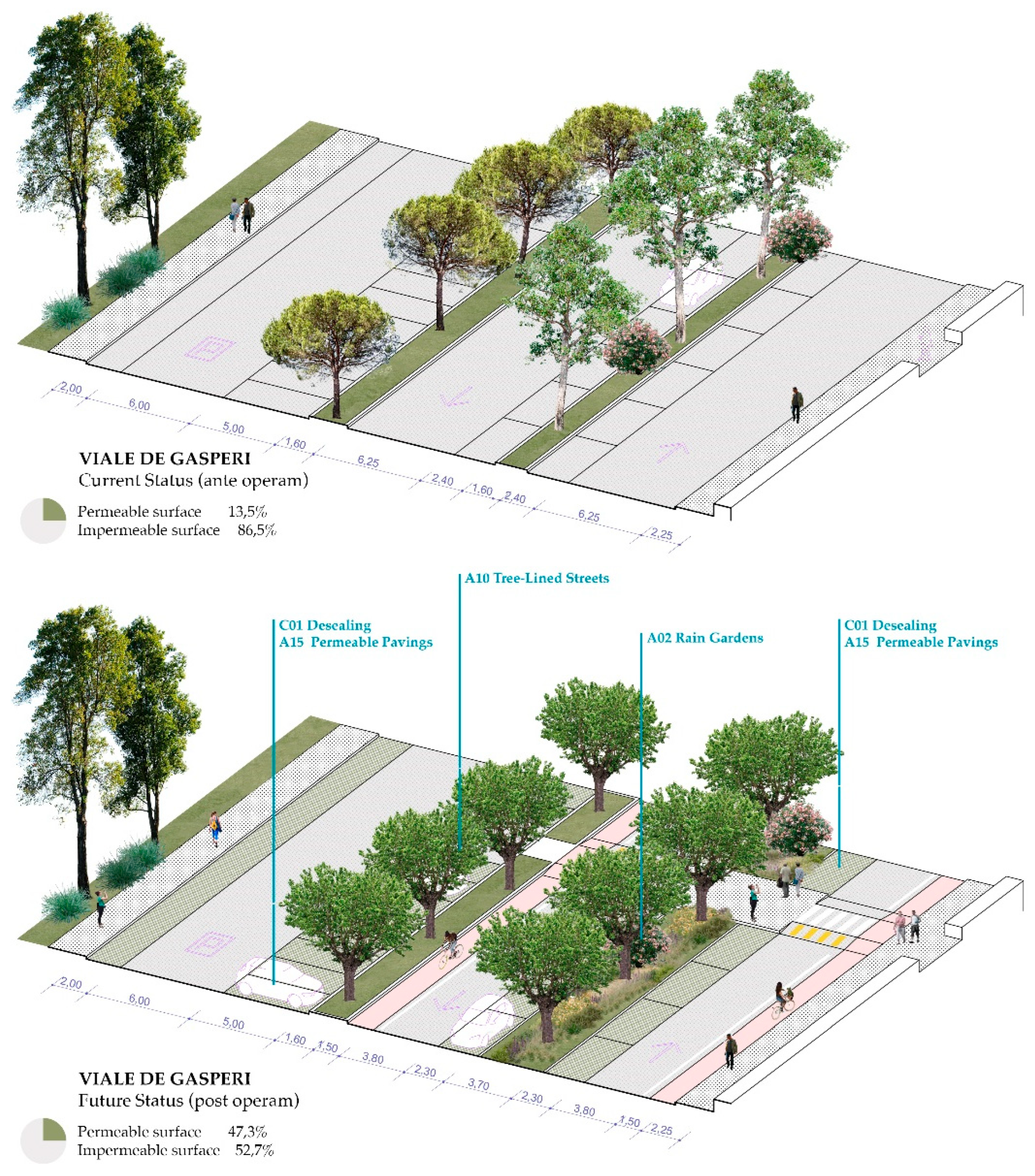
Figure 4.
Cross-sections of via Lombardia ante operam and post operam. The codes refer to a previous deliverable of the Life+ project called DA.1.1.2.
Figure 4.
Cross-sections of via Lombardia ante operam and post operam. The codes refer to a previous deliverable of the Life+ project called DA.1.1.2.
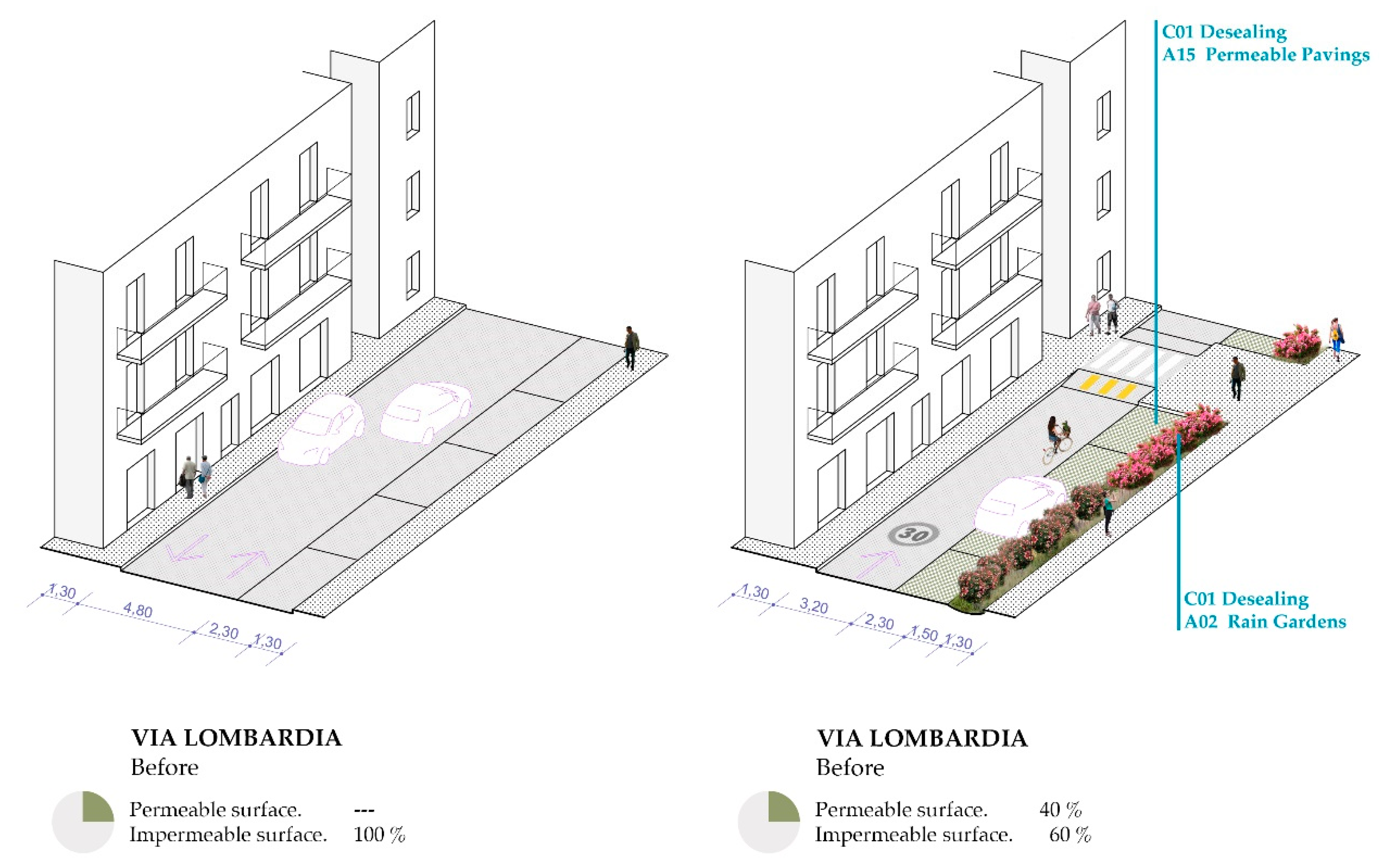
Figure 5.
Plans ante operam and post operam, highlighting permeable surfaces.
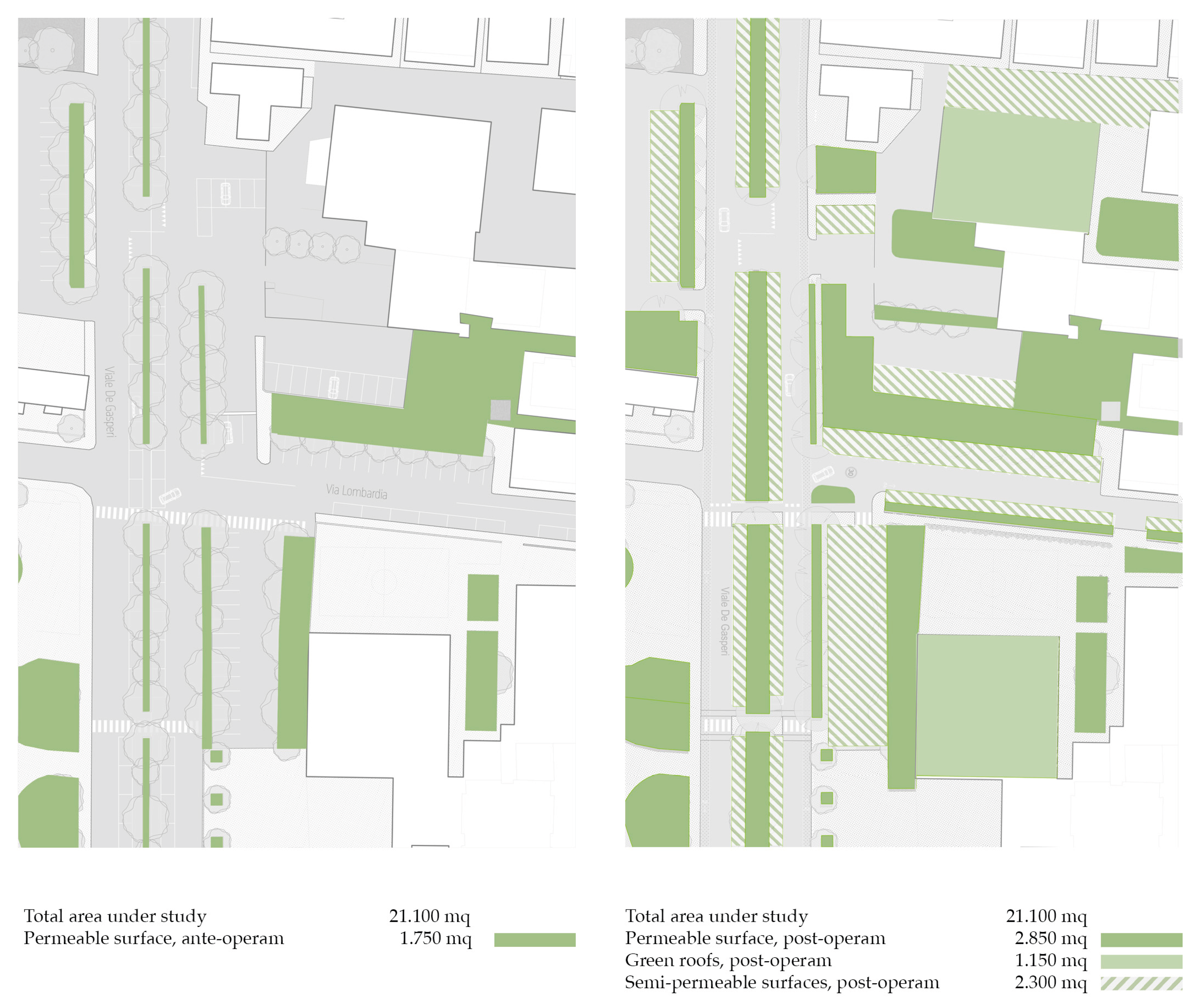

Table 6.
Summary and indicative estimation of construction costs. The estimation does not take into account substantial changes to existing sewerage systems, electrical systems, or road finishes.
Table 6.
Summary and indicative estimation of construction costs. The estimation does not take into account substantial changes to existing sewerage systems, electrical systems, or road finishes.
| Brief description of the intervention | Summary cost (Euro) |
|---|---|
|
Interventions aimed at creating bioretention basins Desealing and restoration of the surface layer of soil Construction of rain gardens, sub-bases, drainage systems, soil, fabrics, and rainwater collection systems Interventions aimed at creating lawns Desealing and restoration of the surface layer of soil Soil preparation and sowing operations Interventions aimed at creating permeable parking lots Desealing and restoration of the surface layer of soil Soil preparation, ballast, sand bed, etc.Drainage paving in interlocking elements Interventions aimed at creating extensive green roofs Preparatory works, supply, installation of green roofing Maintenance and connection works on sidewalks |
13.800,00 51.700,00 14.500,00 2.500,00 38.200,00 59.100,00 76.300,00 230.000,00 20.000,00 |
| Total | 506.100,00 |
4. Discussion
The Sant'Antonio neighborhood project example shows a post-construction condition with several unique features: increased tree coverage with more suitable species; enhanced soil permeability; augmented public space for pedestrians and cyclists; enhanced outdoor thermal comfort, both now and in the future.
From the perspective of climate vulnerability and the urgency with which cities in the central Adriatic region are called upon to respond, the article underscores the significance of a result obtained within an area defined as compact, where there is limited capacity for intervention. The Sant'Antonio district, the subject of this study, has been identified as a climate vulnerability hotspot. Projections indicate that by the year 2050, under the 2050 scenario, the district will experience extremely strong heat stress, a phenomenon that will inevitably lead to a range of consequences [39] if not properly adressed. The analyses and ante-post comparisons demonstrate the efficacy of intervention in reducing peak temperatures and the UTCI value, a particularly salient outcome during peak hours on the hottest days. The comparison also highlights direct benefits from the implementation of GI, in terms of runoff management, carbon storage, carbon sequestration, and oxygen production. This outcome substantiates the imperative for prompt action, even within densely populated areas, and validates the selection of the site as a paradigmatic case study for dense urban regions in the Middle Adriatic [2,20]. The example demonstrates how, in numerous analogous contexts, infrastructure and vehicular spaces are often oversized to accommodate the primary use of automobiles [65]. This fact presents a replicable opportunity for intervention on outdoor urban space, as it is a space that can be modified and allocated for green infrastructure. Despite the apparent saturation of space, there remains the possibility of liberating and utilizing areas for de-sealing and greening.
The article delineates a component of the LIFE+ A_GreeNet project, which transitions from the urban macro-scale to the detailed scale, thereby establishing a methodological detailed design approach, capable of incorporating the necessary sensibilities that every site-specific project should have. The five phases adopted facilitate the translation of macro-scale analyses and objectives into requirements, and consequently, into design choices that are informed by an understanding of the specific issues of the site. The methodological approach is predicated on a series of simulations capable of scientifically defining the benefits that can be achieved through a project such as the one described. The approach under scrutiny is evidently a synthesis of the integration of different disciplines, which requires the specific professional skills of all participants, under the supervision of those who manage the methodological approach itself.
The methodology, which involves the characterization of the "compact city" (or, for other pilot areas, alternative characterizations) and the analysis of the morphological characteristics of this urban portion, can be directly replicated for other coastal cities in the Middle Adriatic. It is imperative to underscore that the analysis presented herein constitutes a component of the overarching methodological framework, a system which, by its very nature, cannot be disassociated from its constituent elements.
The LIFE+ A_GreeNet project entails the dissemination of the tools, methodologies, and findings developed within the project to other Italian coastal municipalities. In light of these considerations, the estimation of construction costs involves a meticulous analysis of the items scheduled for intervention, underscoring the significant discrepancy between the outdoor ground-level and existing buildings rooftops. Consequently, interventions on the ground are regarded as more economical when evaluated on a per square meter basis. This finding indicates that interventions of this type on outdoor space can be readily implemented in other parts of the urban area, even with limited financial resources, or they could be executed in modular functional stages, contingent on the available budget.
5. Conclusions
The critical urban vulnerability of the Middle Adriatic region to climate change necessitates a decisive shift from conceptual GI planning to practical, detailed implementation. This paper addressed the pervasive challenge of translating high-level strategic visions into executable, site-specific projects—a gap particularly pronounced in dense, spatially constrained Mediterranean urban environments.
The core contribution of this research is the presentation and application of a replicable, multi-disciplinary, five-phase methodology developed within the framework of the LIFE+ A_GreeNet project. This methodology operationalized strategic GI goals by integrating macro-scale climate risk assessments with detailed on-site diagnostics (ante-operam analysis) to define a robust framework of technical requirements and specific Nature-Based Solution choices.
The pilot study in the Sant’Antonio district of San Benedetto del Tronto provided empirical evidence of the methodology’s efficacy. Despite being a highly dense urban hotspot projected to face "extremely strong heat stress," the analysis revealed significant opportunities for spatial optimization through the re-appropriation of oversized vehicular areas and the targeted introduction of climate-adapted GI. This demonstrates that precise GI design allows municipalities to reclaim seemingly saturated urban space, creating portions of the city that are fundamentally more resilient against an evolving hotter and drier climate. Crucially, the outcome transcends mere technical adaptation, resulting in environments that are measurably safer, more comfortable, and actively human-centered.
This detailed planning framework serves as a tangible, transferable model for the partner municipalities of LIFE+ A_GreeNet and other Mediterranean coastal cities facing similar socio-spatial and environmental pressures. The immediate subsequent step must be the physical realization of these detailed interventions. Only through the concrete implementation of these projects can the expected efficacy of the NBS be validated over time, allowing for long-term monitoring of their micro-climatic and ecosystem performance.
Future research must particularly address the persistent challenges in integrating new GI and NBS solutions with existing "grey" urban infrastructure, notably concerning subsurface complexity and stormwater management systems. The lack of detailed historical knowledge regarding existing underground networks and the frequent under-dimensioning of current infrastructure present significant barriers. Further efforts should focus on securing resources for the construction phase, developing comprehensive Life-Cycle Assessment tools, and promoting interdisciplinary collaboration to overcome these subsurface integration challenges, thereby ensuring the widespread and effective adoption of climate-resilient solutions
Supplementary Materials
Supporting information, including the LIFE+ A_GreeNet projects and deliverables, can be downloaded at: https://www.lifeagreenet.eu/site/.
Author Contributions
Conceptualization, T.D.B.; methodology, T.D.B and S.M.; software, S.M.; validation, T.D.B.; formal analysis, T.D.B and S.M.; investigation, T.D.B and S.M.; resources, T.D.B and S.M.; data curation, T.D.B and S.M.; writing—original draft preparation, T.D.B.; writing—review and editing, T.D.B and S.M.; visualization, T.D.B and S.M. All authors have read and agreed to the published version of the manuscript.
Funding
This publication received no external funding. The LIFE+A_GreeNet project is co-funded by the European Union through the LIFE program, LIFE20 CCA/IT/001752.
Data Availability
Some of the data from the previous phases of the Life+ project can be found by consulting the A_GreeNET explorer platform, clicking directly on the targeted area. In addition to climate data, the platform provides design guidelines tailored to the type of urban area under analysis: https://lifeagreenet-explorer.eu LIFE+ A_GreeNet Deliverable DA.1.1.2, Repertoire of NBS interventions: https://www.lifeagreenet.eu/site/wp-content/uploads/2023/10/DA.1.1.2-Def-310322-2.pdf. The detailed books (LIFE+ A_GreeNet Deliverable DA.2.1.1) regarding the various analyzed areas of the project, including San Benedetto del Tronto, and including the visualizations related to simulations performed with ENVI-MET, are available in the repository at the link: https://doi.org/10.5281/zenodo.14894783. LIFE+ A_GreeNet Deliverable DA.3.2, Large-scale climate and health framework: maps of risk, climate vulnerability, and health vulnerability today, in 2030, and in 2050: https://www.lifeagreenet.eu/site/wp-content/uploads/2023/10/DA.1.1.2-Def-310322-2.pdf
Acknowledgments
The authors have reviewed and edited the output and take full responsibility for the content of this publication.
Conflicts of Interest
The authors declare no conflicts of interest
Abbreviations
The following abbreviations are used in this manuscript:
| GI | Green Infrastructure |
| UTCI | Universal Thermal Climate Index |
References
- Liquete, C.; Udias, A.; Conte, G.; Grizzetti, B.; Masi, F. Integrated Valuation of a Nature-Based Solution: A Case Study of Water Purification in the Tordera River Basin, Spain. Ecosystem Serv. 2016, 21, 192–203. [Google Scholar] [CrossRef]
- Dorst, H.; van Zanten, A.; Raven, R.; Runhaar, H. Urban Greening through Nature-Based Solutions–Key Characteristics of an Emerging Concept. Sustainable Cities Soc. 2019, 49, 101620. [Google Scholar] [CrossRef]
- La Notte, A.; Zulian, G.; Croci, E.; Lucchitta, B. An Ecosystem Services-Based Approach to Frame NBS in Urban Context. In Nature-Based Solutions for More Sustainable Cities – A Framework Approach for Planning and Evaluation; Emerald publishing, 2021. [Google Scholar]
- Hallegatte, S.; Corfee-Morlot, J. Understanding Climate Change Impacts, Vulnerability, and Adaptation at City Scale: An Introduction. Clim. Change 2011, 104, 1–12. [Google Scholar] [CrossRef]
- Pereira, P.; Wang, F.; Inacio, M.; Kalinauskas, M.; Bogdzevič, K.; Bogunovic, I.; Zhao, W.; Barcelo, D. Nature-Based Solutions for Carbon Sequestration in Urban Environments. Curr. Opin. Environ. Sci. Health 2024, 37, 100536. [Google Scholar] [CrossRef]
- Biswal, B.K.; Bolan, N.; Zhu, Y.; Balasubramanian, R. Nature-based Systems (NbS) for Mitigation of Stormwater and Air Pollution in Urban Areas: A Review. Resour. Conserv. Recycl. 2022, 186, 106578. [Google Scholar] [CrossRef]
- Wanner, A.; Pröbstl-Haider, U.; Feilhammer, M. New green infrastructures for european cities: Multiple ways for improvement and climate change adaptation. In Wit Transactions on Ecology and The Environment.; 2022. [Google Scholar] [CrossRef]
- Nieuwenhuijsen, M.J. New Urban Models for More Sustainable, Liveable and Healthier Cities Post Covid19; Reducing Air Pollution, Noise and Heat Island Effects and Increasing Green Space and Physical Activity. Environ. Int. 2021, 157, 106850. [Google Scholar] [CrossRef]
- Gehl, J. Life between Buildings: Using Public Space; The Danish Architectural Press, 1971. [Google Scholar]
- Ramos-Vidal, I.; Domìnguez de la Ossa, E. A Systematic Review to Determine the Role of Public Space and Urban Design on Sense of Community. Int. Sci. J. 2023. [Google Scholar] [CrossRef]
- D’Onofrio, R.; Trusiani, E. Città, Salute e Benessere. Nuovi Percorsi Per L’urbanistica; FrancoAngeli: Milano, 2018. [Google Scholar]
- Salvo, D.; Banda, J.A.; Sheats, J.L.; Winter, S.J.; Lopes dos Santos, D. Impacts of Temporary Urban Pop-up Park on Physical Activity and Other Individual- and Community-Level Outcomes; The New York Academy of Medicine: New York, NY, 2017. [Google Scholar]
- Intergovernmental Panel on Climate Change (IPCC). Climate Change 2022: Impacts, Adaptation and Vulnerability. Contribution of Working Group II to the Sixth Assessment Report of the Intergovernmental Panel on Climate Change; Cambridge University Press, 2022. [Google Scholar]
- World Health Organization (WHO). COP28 UAE Declaration on Climate and Health. 2023. Available online: https://cdn.who.int/media/docs/default-source/climate-change/cop28/cop28-uae-climate-and-health-declaration.pdf?sfvrsn=2c6eed5a\_3&download=true (accessed on 17 November 2025).
- Matos Silva, M. Public Spaces for Water – A Design Notebook; CRC Press: Leida, 2019. [Google Scholar]
- Castelo, S.; Amado, M.; Ferreira, F. Challenges and Opportunities in the Use of Nature-Based Solutions for Urban Adaptation. Sustainability 2023, 15, 7243. [Google Scholar] [CrossRef]
- Cortinovis, C.; Olsson, P.; Boke-Olén, N.; Hedlund, K. Scaling Up Nature-Based Solutions for Climate-Change Adaptation: Potential and Benefits in Three European Cities. Urban For. Urban Green. 2022, 67, 127450. [Google Scholar] [CrossRef]
- Oral, H.V.; Carvalho, P.; Gajewska, M.; Ursino, N.; Masi, F.; Hullebusch, E.D.; Kazak, J.K.; Exposito, A.; Cipolletta, G.; Andersen, T.R.; Finger, D.C.; Simperler, L.; Regelsberger, M.; Rous, V.; Radinja, M.; Buttiglieri, G.; Krzeminski, P.; Rizzo, A.; Dehghanian, K.; Nikolova, M.; Zimmermann, M. A Review of Nature-Based Solutions for Urban Water Management in European Circular Cities: A Critical Assessment Based on Case Studies and Literature. Blue-Green Syst. 2022, 2, 1–32. [Google Scholar] [CrossRef]
- Mancuso, S. Fitopolis, La Città Vivente; Laterza, 2023. [Google Scholar]
- Ajirotutu, R.; Adeyemi, A.; Ifechukwu, G.; Iwuanyanwu, O.; Ohakawa, T.; Garba, P. Designing Policy Frameworks for the Future: Conceptualizing the Integration of Green Infrastructure into Urban Development. World J. Adv. Res. Rev. 2024, 24, 911–923. [Google Scholar] [CrossRef]
- Pietrapertosa, F.; Olazabal, M.; Simoes, S.; Salvia, M.; Fokaides, P.; Ioannou, B.; Viguié, V.; Spyridaki, N.-A.; Hurtado, S.D.G.; Geneletti, D.; et al. Adaptation to Climate Change in Cities of the Mediterranean Europe. Social Science Research Network (SSRN) Working Paper, 2023.
- Lara, A.; del Moral, L. Nature-Based Solutions to Hydro-Climatic Risks: Barriers and Triggers for Their Implementation in Seville (Spain). Land 2022, 11, 868. [Google Scholar] [CrossRef]
- Macaione, I.; Raffa, A.; Andaloro, B. Climate-Adaptive Nature-Based Regenerative Urban Green Streetscapes: Design Exploration from the City of Matera. Sustainability 2024, 16, 6811. [Google Scholar] [CrossRef]
- Voskamp, I.M.; De Luca, C.; Polo-Ballinas, M.B.; Hulsman, H.; Brolsma, R. Nature-Based Solutions Tools for Planning Urban Climate Adaptation: State of the Art. Sustainability 2023, 13, 6381. [Google Scholar] [CrossRef]
- Organization for Economic Co-operation and Development (OECD). Developing an Integrated Approach to Green Infrastructure in Italy (OECD Public Governance Reviews); OECD Publishing: Paris, 2023. [Google Scholar] [CrossRef]
- Pröbstl-Haider, U.; Haider, W. Nature-based solutions in climate change adaptation and mitigation and in strategies for sustainable tourism development. J. Outdoor Recreat. Tour. 2024, 45, 100700. [Google Scholar]
- Sahay, S. Nature-based solutions as urban adaptation to climate risk: Framework for economic evaluation as decision support tool. Sustainable Cities and Society 2025, 118. [Google Scholar] [CrossRef]
- Guarino, R.; Catalano, C.; Pasta, S. Beyond Urban Forests: The Multiple Functions and the Overlooked Role of Semi-Natural Ecosystems in Mediterranean Cities. Diversity 2024, 16, 447. [Google Scholar] [CrossRef]
- McPhearson, T.; Frantzeskaki, N.; Ossola, A.; Diep, L.; Anderson, P.M.L.; Blatch, T.; Collier, M.J.; Cook, E.M.; Culwick Fatti, C.; Grabowski, Z.J.; Grimm, N.B.; Haase, D.; Herreros-Cantis, P.; Kavonic, J.; Lin, B.B.; Lopez Meneses, D.H.; Matsler, A.M.; Moglia, M.; Morató, J.; O'Farrell, P.; Roy, P.; Singh, C.; Wang, J.; Zhou, W. Global Synthesis and Regional Insights for Mainstreaming Urban Nature-Based Solutions. Proc. Natl. Acad. Sci. 2025, 122, e2315910121. [Google Scholar] [CrossRef]
- Castelar, J.A.C.; Popartan, L.A.; Pucher, B.; Pineda-Martos, R.; Hecht, K.; Katsou, E.; Nika, C.E.; Junge, R.; Langergraber, G.; Atanasova, N.; Comas, J.; Monclús, H.; Pueyo-Ros, J. What Does It Take to Renature Cities? An Expert-Based Analysis of Barriers and Strategies for the Implementation of Nature-Based Solutions. J. Environ. Manage 2024, 354, 120385. [Google Scholar] [CrossRef]
- Bagiouk, S.; Sotiriadis, D.; Katsifarakis, K.L. Combining Pocket Parks with Ecological Rainwater Management Techniques in High-Density Urban Environments. Environ. Processes 2024, 11, 7. [Google Scholar] [CrossRef]
- Chelli, A.; Brander, L.; Geneletti, D. Cost-Benefit Analysis of Urban Nature-Based Solutions: A Systematic Review of Approaches and Scales with a Focus on Benefit Valuation. Ecosystem Serv. 2025, 71, 101684. [Google Scholar] [CrossRef]
- Datola, G.; Dell’Ovo, M.; Oppio, A. The Feasibility of Nature-Based Solution (NBS) Interventions: Estimating the Cost Using the Work Breakdown Structure (WBS). Valori e Valutazioni 2025, 37. [Google Scholar] [CrossRef]
- Tuel, A.; Eltahir, E.A.B. Why Is the Mediterranean a Climate Change HotSpot? J. Clim. 2020, 33, 1–49. [Google Scholar] [CrossRef]
- Linares, C.; Díaz, J.; Negev, M.; Martínez, G.S.; Debono, R.; Paz, S. Impacts of Climate Change on the Public Health of the Mediterranean Basin Population-Current Situation, Projections, Preparedness and Adaptation. Environ. Res. 2020, 182. [Google Scholar] [CrossRef]
- Guida, C. I Rischi Naturali Del Cambiamento Climatico Nelle Città Del Mediterraneo; Federico II Open Access University Press: Napoli, 2021. [Google Scholar]
- Tojčić, I.; Denamiel, C.; Vilibić, I. Kilometer-Scale Trends, Variability, and Extremes of the Adriatic Far-Future Climate (RCP 8.5, 2070−2100). Front. Mar. Sci. 2024, 11, 1329020. [Google Scholar] [CrossRef]
- Intergovernmental Panel on Climate Change (IPCC). Climate Change 2022: Impacts, Adaptation and Vulnerability. Contribution of Working Group II to the Sixth Assessment Report of the Intergovernmental Panel on Climate Change; Cambridge University Press, 2022. [Google Scholar]
- Intergovernmental Panel on Climate Change (IPCC). Climate Change 2023: Synthesis Report. Contribution of Working Groups I, II and III to the Sixth Assessment Report of the Intergovernmental Panel on Climate Change; Core Writing Team, Lee, H., Ed.; IPCC: Geneva, Switzerland, 2023.
- Tousi, E.; Mela, A.; Tseliou, A. Nature-Based Urbanism for Enhancing Senior Citizens’ Outdoor Thermal Comfort in High-Density Mediterranean Cities: ENVI-met Findings. Urban Sci. 2025, 9, 152. [Google Scholar] [CrossRef]
- Cramer, W.; Guiot, J. The Mediterranean as a Climate Change Hotspot: Implications for State and Societal Resilience. In Climate Change and Security in the Mediterranean: Exploring the Nexus, Unpacking International Policy Responses; Dessì, A., Fusco, F., Eds.; Edizioni Nuova Cultura: Roma, 2022. [Google Scholar]
- Mazzalai, A. Urban Heat Island and Heat-Related Health Risk: A Case Study of the City of Florence, Italy. Urban Clim. 2023, 51, 101645. [Google Scholar]
- ISPRA (Istituto Superiore per la Protezione e la Ricerca Ambientale). In Rapporto Consumo di Suolo, Dinamiche Territoriali e Servizi Ecosistemici, Edizione 2023; ISPRA: Roma, Italia, 2023.
- Sciuto, L.; Licciardello, F.; Scavera, V.; Verde, D.; Giuffrida, E.R.; Cirelli, G.L. The Role of Nature-Based Solutions for the Water Flow Management in a Mediterranean Urban Area. Ecol. Eng. 2024, 208, 107375. [Google Scholar] [CrossRef]
- Nastos, P.; Saaroni, H. Living in the Mediterranean Cities in the Context of Climate Change: A Review. Int. J. Climatol. 2024. [Google Scholar] [CrossRef]
- The World Bank. Nature-Based Solutions for Climate Resilience in Cities: A Guide for Practitioners; The World Bank: Washington, D.C., 2021. [Google Scholar]
- Versini, P.A.; Al Sayah, M.; Duffaut, C.; Schertzer, D. How to Choose the Most Relevant Nature-Based Solutions and to Assess Their Performances? Insight from Two Projects Implemented on the French Territory. EGU General Assembly 2022, Vienna, EGU22-9465, 2022. [CrossRef]
- LIFE+ A_GreeNet project. Available online: https://www.lifeagreenet.eu/site/ (accessed on 18 November 2025).
- Brownlee, T.D. Design with climate variables, tecnologie per un adattamento temporaneo al cambiamento climatico; FrancoAngeli: Milano, 2023. [Google Scholar]
- Vilanova, C.; Ferran, J.F.; Concepción, E.D. Integrating Landscape Ecology in Urban Green Infrastructure Planning: A Multi-Scale Approach for Sustainable Development. Urban For. Urban Green. 2024, 94, 128248. [Google Scholar] [CrossRef]
- Maragno, D.; Litt, G.; Ferretto, L.; Gerla, F. Abaco per la transizione climatica, Anteferma. 2022. [Google Scholar]
- Esraz-Ul-Zannat, M.; Dedekorkut-Howes, A.; Morgan, E.A. A Review of Nature-Based Infrastructures and Their Effectiveness for Urban Flood Risk Mitigation. WIREs Clim. Change 2023, e889. [Google Scholar] [CrossRef]
- Aparicio Uribe, C.; Bonilla Brenes, R.; Hack, J. Potential of Retrofitted Urban Green Infrastructure to Reduce Runoff - A Model Implementation with Site-Specific Constraints at Neighborhood Scale. Urban For. Urban Green. 2022, 69, 127499. [Google Scholar] [CrossRef]
- Minixhofer, P.; Scharf, B.; Hafner, S.; Weiss, O.; Henöckl, C.; Greiner, M.; Room, T.; Stangl, R. Towards the Circular Soil Concept: Optimization of Engineered Soils for Green Infrastructure Application. Sustainability 2022, 14, 905. [Google Scholar] [CrossRef]
- Fang, X.; Li, J.; Ma, Q.; Zhou, R.; Du, S. A Quantitative Review of Nature-Based Solutions for Urban Sustainability (2016–2022): From Science to Implementation. Sci. Total Environ. 2024, 927, 172219. [Google Scholar] [CrossRef]
- Croeser, T.; Garrard, G.; Sharma, R.; Ossola, A.; Bekessy, S. Choosing the Right Nature-Based Solutions to Meet Diverse Urban Challenges. Urban For. Urban Green. 2021, 65, 127337. [Google Scholar] [CrossRef]
- United States Environmental Protection Agency (EPA). EPA 841-B-21-001; Green Streets Handbook. Office of Water: Washington, D.C., 2021.
- Guarino, R.; Catalano, C.; Pasta, S. Beyond Urban Forests: The Multiple Functions and the Overlooked Role of Semi-Natural Ecosystems in Mediterranean Cities. Diversity 2024, 16, 447. [Google Scholar] [CrossRef]
- Sommese, F.; Diana, L.; Colajanni, S.; Bellomo, M.; Sciuto, G.; Lombardo, G. Towards a Regenerative and Climate-Resilient Built Environment: Greening Lessons from European Cities. Buildings 2025, 15, 1878. [Google Scholar] [CrossRef]
- Raffa, A.; Moscatelli, M. Rigenerazione Urbana Green: Progettare Streetscapes Resilienti Al Clima Attraverso NbS. Techne 2025, 29. [Google Scholar] [CrossRef]
- Ye, C.; Gao, J.; Nachabe, M.; Charkhgard, H.; Zhang, Y.; Zhang, Q. Optimization of Green and Grey Infrastructure for Performance Enhancement of Urban Drainage System under Future Conditions. J. Environ. Manage 2025, 376, 124518. [Google Scholar] [CrossRef]
- Cecchi, J.; Malavolta, S.; D'Onofrio, R.; Marchesani, G.E.; Catorci, A.; Giorgini, I. LIFE+ A_GreeNet - data & report iTree Eco. Zenodo 2025. [Google Scholar] [CrossRef]
- Rodriguez-Valencia, A.; Ortiz-Ramirez, H.A. Understanding Green Street Design: Evidence from Three Cases in the U.S. Sutainability 2021, 13, 1916. [Google Scholar] [CrossRef]
- Eggimann, S. Deprioritising Cars Beyond Rerouting: Future Research Directions of the Barcelona Superblock. Cities 2025, 157, 105609. [Google Scholar] [CrossRef]
- Romm, D.; Jasso Chávez, J.A.; Kinman, L.; Salsabilian, P.; McKenzie, G.; Manaugh, K. The Cars Are Going to Be Alright: Examining Micromobility Infrastructure Space Allocation and Potential Improvement Scenarios in Montréal. J. Cycl. Micromobility Res. 2025, 5, 100071. [Google Scholar] [CrossRef]
Figure 1.
General plan of the intervention area, ante operam. The buildings are white and the colored hatches refer to the outdoor urban space.
Figure 1.
General plan of the intervention area, ante operam. The buildings are white and the colored hatches refer to the outdoor urban space.
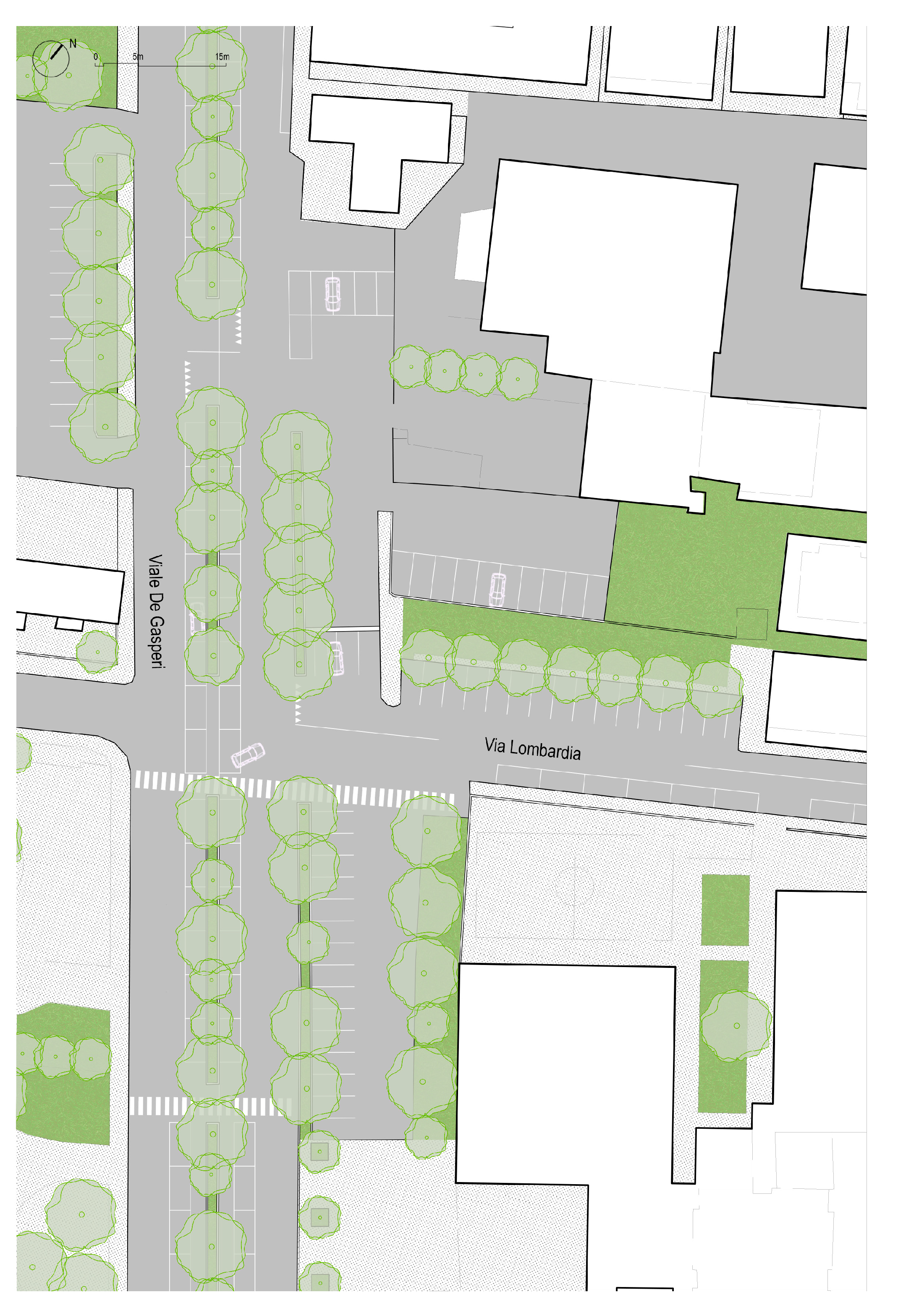
Figure 2.
General plan of the intervention area, post operam. The codes refer to a previous deliverable of the Life+ project called DA.1.1.2 Repertory of NBS interventions and tree species for the physical and mental well-being of the urban community.
Figure 2.
General plan of the intervention area, post operam. The codes refer to a previous deliverable of the Life+ project called DA.1.1.2 Repertory of NBS interventions and tree species for the physical and mental well-being of the urban community.
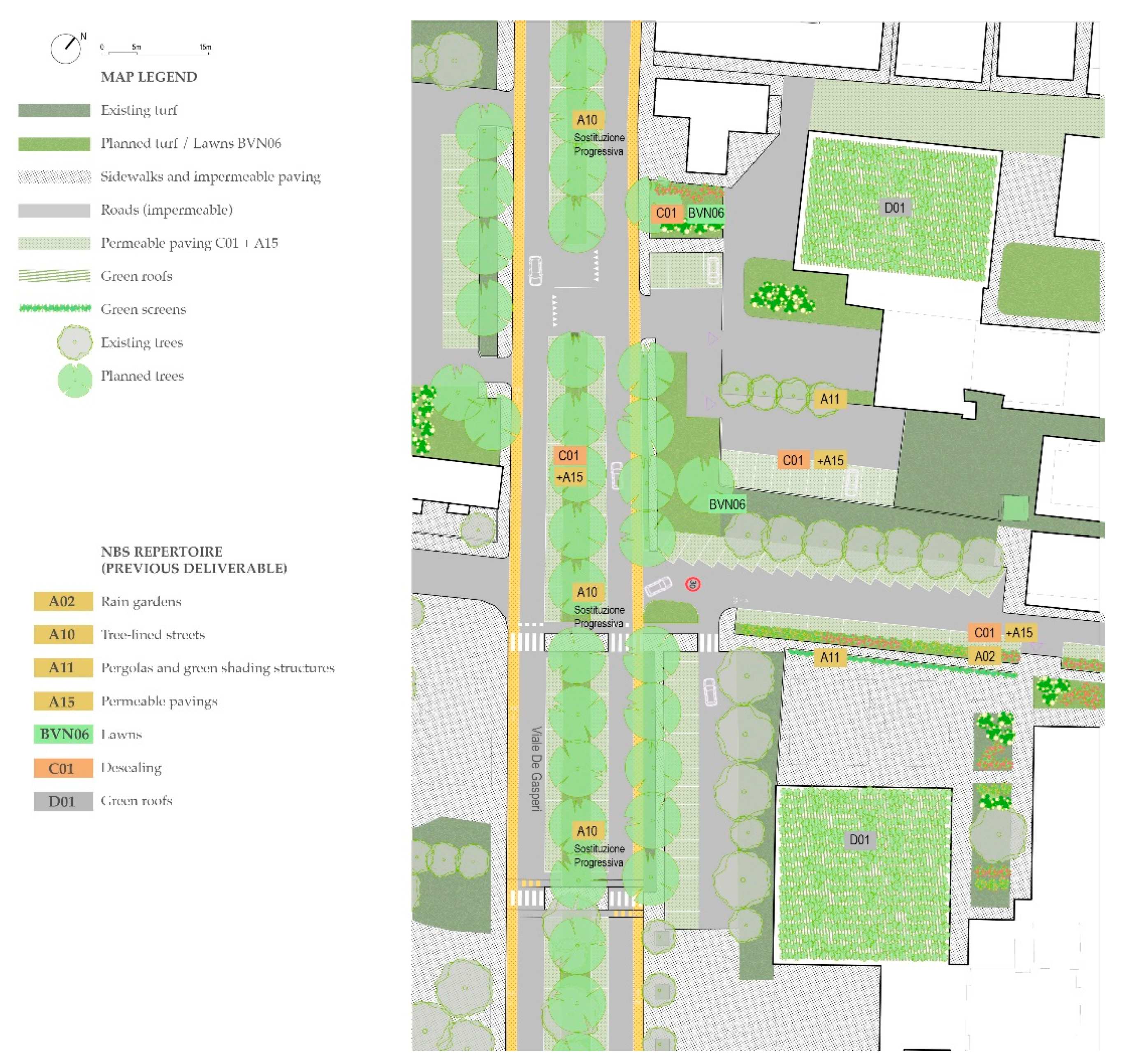
Table 1.
Methodological workflow for this stage of the project (antecedent and preparatory project phases indicated by dashed lines).
Table 1.
Methodological workflow for this stage of the project (antecedent and preparatory project phases indicated by dashed lines).
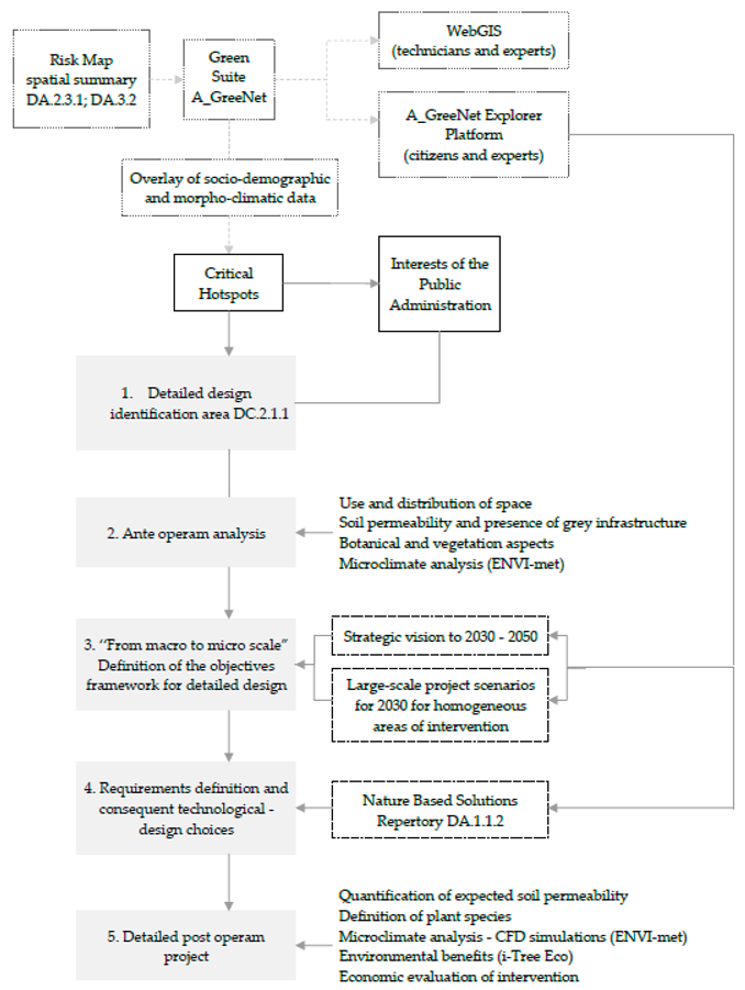
Table 2.
Macro-scale objectives as previously described in D.C. 2.1.1 and D.C. 2.1.2 of the Life project, specifically referring to the compact portion of the city of San Benedetto del Tronto.
Table 2.
Macro-scale objectives as previously described in D.C. 2.1.1 and D.C. 2.1.2 of the Life project, specifically referring to the compact portion of the city of San Benedetto del Tronto.
| GI construction goals | Climate adaptation goals | Project Scenario 2030 | Project Scenario 2050 |
|---|---|---|---|
| Regeneration of public space and building fabrics through greening and micro-forestry interventions. | Cooling of the urban environment; Reduction of air pollution; Health and well-being of inhabitants. | Initiation of public space regeneration along the squares and the streets. De-sealing interventions, installation of permeable paving, and qualitative improvement of existing public green spaces. Introduction of new non-allergenic trees, micro-forestry interventions, and integration of Nature-Based Solutions (NBS). |
Interventions targeting small-scale public spaces and building courtyards through greening and de-sealing of existing parking areas. |
Table 3.
The table shows the framework described in section 3.3 (Needs) and section 3.4 (Requirements and design and technological choices).
Table 3.
The table shows the framework described in section 3.3 (Needs) and section 3.4 (Requirements and design and technological choices).
| Aspects | Needs Framework | Requirements | Technological- design choices |
| Spatial-functional | Streets. Foster the use of urban space by pedestrians and cyclists and increase the amount and quantity of greenery without compromising vehicular traffic. |
Minimum provision of comfortable, attractive and safe outdoor urban space. | Via Lombardia can become one-way with a reduced carriageway of 3.30m wide. Space is created for the insertion of a bioretention device and to increase space for pedestrians. Viale De Gasperi there can be a reduction of the carriageways to 3.80m. This allows the creation of cycle lanes in both directions, the insertion of a large vegetated flowerbed (from 1.60 m to 3.70 m) which can accommodate bioretention basins and large safe spaces for pedestrians to cross and stop, equipped with benches and street furniture. It is also planned to rationalize spaces designated for motor vehicle traffic in order to increase green pedestrian areas. |
| Parking spaces. Rationalize maneuvering spaces and parking areas to obtain areas that can be used for other purposes. | Reduction in parking area with total number of parking spaces unchanged. |
Parking areas are rationalized, double access points are removed, and spaces are created for the purposes of the project. | |
| Construction of the GI | Implementation and consolidation of widespread green intervention in public spaces. |
Continuity of the GI to supplement the existing one. |
The creation of new green spaces allows for increasing green capacity and integrating it into the existing network. Insertion and replacement of high-risk tree species. Wojtyla Park is located to the west of the project area. The extension and densification of the tree-lined avenue will serve as a connection to the park, promoting the creation of ecological networks. |
| Effective tree cover. | Selection of trees and bushes based on current and projected climate, as well as site characteristics and distance from the sea. | Trees: Morus Alba; Bushes: Solanus Jasminoides, Rosa Banskia arbustiva, Rosa Chinensis |
|
| Climate adaptation | Improving outdoor microclimate comfort, particularly cooling and counteracting the urban heat island effect; Sustainable rainwater management with a view to reducing flooding and runoff; Reducing sewage load; Health and well-being of residents and users. |
Minimum number of trees along main roads; Use of materials suitable for hot temperatures and long, continuous exposure to solar radiation; Capacity of the sewerage system to cope with the effects of extreme events; Provision of green and blue infrastructure integrated with existing gray infrastructure; Capacity of urban bioretention basins capable of absorbing and slowing down rainwater runoff; Minimum provision of green space with trees to benefit from the effects of shade and evapotranspiration. |
Allocating the highest possible number of tall trees along the road, in parks, and within newly created surfaces; Replacement of existing pavements with high albedo materials (cool pavement) in order to reduce surface temperatures; Creation of green roofs when feasible, for example on flat roofs of schools and public buildings; Creation of road sections with slopes towards bioretention basins, which are specially sized according to the collection areas and extreme precipitation forecasts. |
| Technological- Constructive | Economy; Replicability; Speed in the implementation phase; Ability to carry out interventions without compromising the functionality (vehicular and pedestrian) of the area; Compatibility with under services lines. |
Easy to install; Easy to maintain; Possibility of implementation for modular segments or phases. |
Constructive systems with materials and components available on site and construction methods implemented starting from knowledge not foreign to local workers. Identify modular technological solutions and materials easy to replace and maintain over time |
Table 4.
Comparison table before and after, data extrapolated using I-Tree software.
| Ante | Post | |
|---|---|---|
| Number of trees | 39 | 59 |
| Tree cover | 6,1 % | 15,1 % |
| Pollution removal | 2,26 kg/year (€ 18/year) | 4,52 kg/year (€ 31,7/year) |
| Carbon Storage | 20.390 kg (€ 3280) | 23.370 kg (€ 3760) |
| Carbon sequestration | 1163 kg (€ 187/anno) | 1849 kg (€ 297/anno) |
| Oxygen production | 3101 kg/year | 4931 kg/anno |
| Avoided runoff | 1,82 m³/year (€ 3,45/year) | 3,47 m³/year (€ 6,61/year) |
Table 5.
UTCI Comparison table ante and post operam, years 2019 and 2030, significant day July 21st 2030; data extrapolated using ENVI-met software and referred to the central point of the area.
Table 5.
UTCI Comparison table ante and post operam, years 2019 and 2030, significant day July 21st 2030; data extrapolated using ENVI-met software and referred to the central point of the area.
| UTCI ANTE (°C) in case of no intervention |
UTCI POST (°C) in case of implementing the design proposal |
|
|---|---|---|
| July 21st 2019 at 2:00 PM | 41° | 37° |
| July 21st 2030 at 2:00 PM | 47° | 43° |
Disclaimer/Publisher’s Note: The statements, opinions and data contained in all publications are solely those of the individual author(s) and contributor(s) and not of MDPI and/or the editor(s). MDPI and/or the editor(s) disclaim responsibility for any injury to people or property resulting from any ideas, methods, instructions or products referred to in the content. |
© 2025 by the authors. Licensee MDPI, Basel, Switzerland. This article is an open access article distributed under the terms and conditions of the Creative Commons Attribution (CC BY) license (http://creativecommons.org/licenses/by/4.0/).
Copyright: This open access article is published under a Creative Commons CC BY 4.0 license, which permit the free download, distribution, and reuse, provided that the author and preprint are cited in any reuse.


