
Submitted:
11 December 2025
Posted:
14 December 2025
You are already at the latest version
Abstract
Urban waterfront regeneration driven by mega-events has played a key role in shaping contemporary public open spaces, particularly in newly developed areas within the Chinese context. However, public perceptions and their influence on the use of newly built open spaces created through mega-event-led regeneration have not been examined in existing research. To address this gap, this study establishes an integrated assess-ment framework to evaluate the quality of urban waterfront open spaces. A mixed methods approach was adopted, including direct observations and 770 online ques-tionnaires collected between July and October 2024 around core nodes along the South Bank of the Qiantang River in Hangzhou, China. Spatial analysis and Importance–Performance Analysis (IPA) were employed to determine priority improvement areas that should inform future waterfront regeneration strategies. The results indicate that inclusiveness emerged as the most important factor for enhancing waterfront open space quality, while spatial aesthetics ranked the lowest. Among the sub-sub factors, elements related to improving water accessibility, enhancing natural surveillance, providing artificial shelters and diverse seating options and shaping collective memory through digital technologies received the highest ratings. Finally, the study highlights that the intangible legacies of the Asian Games have the potential to reshape a distinc-tive new city image and collective memory, even in the lack of tangible heritage build-ings.
Keywords:
urban waterfront regeneration
; urban waterfront open space quality
; placemaking approaches
1. Introduction
Urban waterfront regeneration can be understood as a continuous city-building activity that reshapes the public realm of urban waterfront open spaces in a more sustainable manner across social, ecological, economic, cultural and political dimensions [1,2]. Over the past six decades, waterfront regeneration policies have played a key role in shaping contemporary public places, shifting from a focus on industry, manufacturing and transportation to the creation of inclusive and mixed-use public realms globally [3]. These initiatives are characterised by the introduction of cultural flagships as new landmarks [4], the hosting of mega events such as the Olympics, Expo, the Venice Biennale, the European Capital of Culture and cultural festivals [5], the encouragement of community engagement in decision-making processes [6], and the adaptive reuse of urban heritage resources by embedding new functions and meanings into everyday life [7]. In other words, through the transformation of urban waterfront open spaces at the land-water interface, these agendas aim to attract new creative clusters, generate new urban identities, enrich people’s engagement with water in both active and passive ways, climb the urban hierarchy and finally trickle down the profits to all sectors of society [8].
In the Chinese context, culture-led regeneration driven by mega-events has acted as a key paradigm for the transformation of waterfront areas and has reshaped the public realm on waterfronts. In response to evolving human demands for new forms of urban waterfront open spaces, such mega-event-led waterfront regeneration programmes are characterised by two core dimensions: strengthening the connection between mega-event and the urban heritage in public discourse [9] and the embedding of existing public infrastructure into everyday life [10]. On the one hand, as sporting mega-events (most notably the Expo and the Olympic Games) have begun to alter the social and spatial qualities of urban waterfront open spaces, new forms of mega-event-built legacies have emerged. Even when these structures are not formally designated on official heritage lists, they extend beyond physical sports venues and museum clusters and have the potential to generate long-term public and symbolic value [11]. On the other hand, to improve the integration of urban waterfronts into everyday life, many linear ecological corridors have gradually been complemented by a series of publicly accessible Waterfront Public Service Pavilions that provide basic service facilities such as washrooms, lounges, storage lockers, and portable charging stations, particularly along the Huangpu River in Shanghai and the Qiantang River in Hangzhou [12]. These pavilions, conceived as a network of “waterfront community hub” and “shared living rooms”, are distributed at intervals of roughly 800 metres to one kilometre. As key nodes along the urban waterfront, these service pavilions play a crucial role in facilitating community participation.
As newly built waterfront open spaces regenerated through mega-event-led, state-led approaches are still in the process of shaping urban memory, evaluating their success in achieving high socio-spatial quality requires attention not only to spatial design and ecological enhancements, but also to how people perceive, interpret, and use these places in everyday life. Rapoport [13] highlights the perception of environmental quality as a key factor in shaping urban transformation. The interpretation of perceptions and attitudes is a process of encoding and decoding information comprising environmental evaluation, environmental cognition and direct sensory experience by given distinctive meanings. Such understanding of perceptions and attitudes provides deeper insight into how the physical environment affects behaviours, and how people, in turn, reshape the urban fabric and social relations. It is also essential for informing people-centred urban planning and mitigating the shortcomings of conventional top-down urban planning processes in the Chinese context.
However, existing literature has not fully examined how these perceptions and attitudes shape the socio-spatial quality of public places, particularly in newly developed waterfront areas transformed through event-led regeneration. Furthermore, most studies employ generic public space quality assessment frameworks when evaluating urban waterfront open spaces; however, such frameworks lack the necessary specificity to refine sub-indicators and associated variables in ways that reflect the distinctive socio-spatial characteristics of waterfront open spaces. Therefore, this study aims to establish an integrated urban waterfront open space quality assessment framework that integrates place making theory and urban waterfront design principles. It further demonstrates how users’ perceptions and attitudes can inform future waterfront regeneration policies and placemaking-based approach.
2. Theoretical Framework
2.1. Placemaking Approach and Associated Assessment Frameworks
The emergence of the placemaking approach was driven by urban design scholars who, since the 1960s, have criticised the lack of attention given to public space in the planning of new towns and city centres [14,15]. Furthermore, Relph [16] emphasises the significance of place in everyday life and how it is manifested through shaping the identity of place. The identity of place he defines includes three key aspects: (1) the physical setting of the place; (2) activities, events and situations; and (3) the individual and collective meanings created by people’s everyday experiences and attitudes toward that place. Based on Relph’s theory, Montgomery [17] further identifies three key elements that comprise the sense of place, as seen in Figure 1. Such identification reveals that placemaking process has shifted from merely constructing a “space” focused on physical transformation to remaking a successful “place” by putting people and adding meaning at its core.
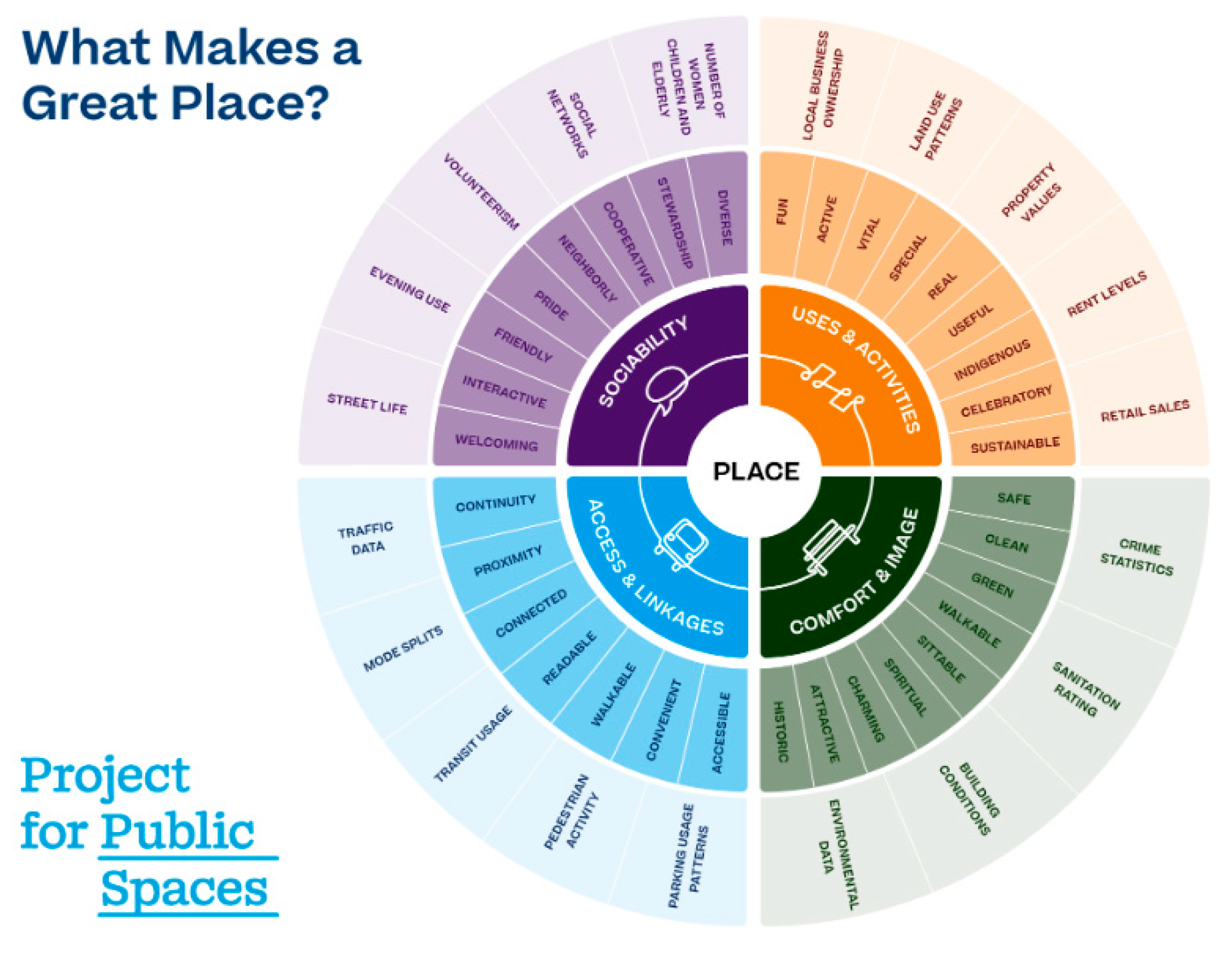
Since 1975, inspired by the placemaking approach, the Project for Public Spaces has been proposed as a community-based approach to address the privatisation of public space and enhance its quality for public use [18]. PPS identifies the following criteria for a successful public space (see Figure 2) [19]:
- Access and linkages: a successful public place is easy to access, navigate and get through. It should have good connections to the surroundings, including visual links. Additionally, design elements include edges that promote permeability and flow, as the edges of a public space play a crucial role in ensuring accessibility.
- Comfort and image: a comfortable place is one where people feel at ease spending time and where a sense of comfort and a positive image are evoked. Creating a sense of comfort involves perceptions of safety, cleanliness, provision of good climatic conditions and the availability of seating.
- Uses and activities: something to do gives people a reason to come to a place, and to return. Key elements include an inviting and open design that allows for a seamless connection and flow between the public and private spaces, encouraging people to visit and stay in the area. The mixed-use function and diversity of activities foster an inclusive public realm
- Sociability: refers to how to build a favourite public place that supports social interaction, such as meeting friends and neighbours and interacting with strangers. These are also the fundamental elements of a public space where people feel included, represented and welcomed in fully expressing themselves, which are also essential in shaping an inclusive public realm.
Overall, placemaking is theorised as an integrated environmental management tool that can boost physical, social and economic construct.
Figure 2.
Dimensions of successful public space (Source: Project for Public Space, 2008).
Drawing on placemaking theory rooted in a people-centred approach, Jan Gehl contends that high-quality public spaces must deliver protection, comfort, and enjoyment from the perspective of users [20]. He subsequently developed a tool based on 12 key criteria for evaluating good public space (see Figure 3). The above indicators were selected based on people’s perceptions of the built environment and the hierarchy of human needs.
In addition, Carmona [21] proposed the concept of the place-shaping continuum, which identifies four key processes, as summarised in Table 1.
In summary, the model of place-shaping continuum (Figure 4) presents a continuous model of urban design that refers to the “self-conscious development of four-dimensional project vision” [22] (p. 41). It helps to understand and explain the nature of urban evolution and city form, while also highlighting the role of designers in maximising benefits for different stakeholders. Anderson and Law [23] argue that the place-shaping continuum represents a circular process through which urban places are shaped by both knowing and unknowing actions within self-conscious and unselfconscious design practice. The term knowing relates to planning consultants, architects and urban designers who are self-consciously involved in the urban design process, while the term unknowing refers to virtually every other member of the community, including the business community, investors, public servants and householders, who shape the city unselfconsciously, without a deliberate urban design agenda [21]. This model serves to integrate key stakeholders in order to explain the functioning of the urban design process.
2.2. Key Strategies for the Successful Design and Planning of Urban Waterfront Development
Urban waterfront open spaces represent a range of complex spatial typologies at the intersection of land and water within the city. They have become a new frontier for mediating between local and global forces, as well as a battleground for negotiating public and private interests among various stakeholders [24]. In this sense, identifying the key strategies is essential for creation of an inclusive and social leisure urban waterfront environment. Gordon [25] suggests that creation of high public realm on urban waterfront where different users can come together and mix is important, which can be achieved by thinking small and planning in increments and coordinating public and private investments. He further emphasises the importance of enhancing public accessibility and connectivity, fostering users’ engagement with the water and integrating waterfronts both with their urban surroundings and with the water itself [25].
In addition, the 10 Principles for Sustainable Development of Urban Waterfront Areas were proposed at the Global Conference on Urban Future (URBAN 21) held in Berlin in July 2000 [26]. Such guidelines highlight the most vital elements in urban waterfront transformation in terms of social, environmental, and economic sustainability. Based on Sepe [26] ’s discussion, such principles include: (1) securing water quality and the environment; (2) recognising that waterfronts are an integral part of the existing urban fabric and the city; (3) preserving and reusing urban historical and cultural resources to give character and meaning; (4) encouraging mixed use by offering a diversity of cultural, commercial, and housing functions, both functionally and socially; (5) ensuring public access (physical, visual, and symbolic) as a prerequisite for various groups; (6) establishing public–private partnerships; (7) developing public participation; (8) recognising that waterfronts are long-term projects that ensure benefits for the whole city; (9) encouraging flexible and adaptable waterfront regeneration strategies and policies; and (10) acknowledging that the complex process of waterfront regeneration involves many disciplines in order to construct an international network of economically profitable waterfronts.
Overall, these waterfront design principles provide a foundation for establishing an integrated assessment framework for the quality of urban waterfront open spaces, particularly by highlighting the importance of establishing continuous waterfront walkways, integrating urban waterfront open spaces into their hinterlands, opportunities for direct human–water interaction, and the necessity of incorporating flood-control and hydrological management into their design process.
2.3. Establishing Integrated Urban Waterfront Open Space Quality Assessment Framework
Drawing on above theories and design principles, this research identifies six key factors, 21 sub-factors and 110 variables to evaluate the quality of urban waterfront open spaces based on users’ perspectives (see Figure 5).
- Access and linkage: this factor can be defined as the extent to which users can reach and enter urban waterfront open spaces through well-integrated connections and physical access with their surrounding context [19,27]. This factor is further categorised into three sub-factors and 15 sub-sub factors in Table 2.
- 2.
- Safety: Although a sense of safety is inherently linked to a sense of comfort, much research has sought to identify it as a distinct indicator and has cited it as a primary consideration in assessing the quality of urban waterfront public spaces [39]. This is because safety serves as a fundamental prerequisite for ensuring users’ well-being. When engaging in urban waterfront open spaces, people may face three major safety challenges: crime prevention, flood risk and traffic safety [20]. Its sub-factors and sub-sub-factors can be seen in Table 3.
- 3.
- Comfort: Making people comfortable in urban settings is crucial for successful urban waterfront open spaces. Carmona [27] points out that the length of time and people stay in a public place is a criterion of its comfort. As Gehl [20] notes, a sense of comfort encourages users to engage in a wide range of necessary, optional and social activities, such as walking, standing, sitting, observing, listening and communicating. It is acknowledged that the feeling of comfort can be influenced by environmental factors and physical configurations, including: the provision of sufficient and comfortable seating, the physical condition of route systems on urban waterfronts, as well as visual and climatic comfort. In this research, comfort is manifested into four sub-factors, as shown below in Table 4.
- 4.
- Spatial aesthetics: Spatial aesthetics comprises spatial (volumetric) and aesthetic effects of the urban environment, emphasising aesthetic order and the intuitive capacity for aesthetic appreciation [27]. Within this framework, Gestalt psychologists argue that the built environment can achieve more significant order, coherence and harmony through the application of design principles, thereby improving its spatial-visual aesthetic qualities [27]. Table 5 shows the factors, sub-factors and sub-sub-factors in the dimension of spatial aesthetics.
- 5.
- Place identity: Montgomery [17] suggests that place identity is rooted not only in the distinctiveness of the physical environment, but also in individuals’ internal psychological and social processes that construct cultural meaning and symbolic value. Such meaning and symbolism can be conceptualised as the social production of space, relating to how the physical form is perceived as memorable or forgettable, liked or disliked, meaningful or not [21]. In this study, place identity includes four sub-factors and sub-sub-factors, which can be seen in Table 6.
- 6.
- Inclusiveness: Mehta [39] suggests that an ideal inclusive public space should accommodate a wide range of activities and enable all social groups to access and utilise the space in support of their daily lives, despite a recognition that public spaces have never been entirely inclusive. Stevens [29] believes that an inclusive public space should be able to change and accommodate new activities in response to user demand. In this context, social cohesion is regarded as a fundamental component of societal stability and interdependence, representing shared loyalties, mutual support and a sense of solidarity and participation among members of a community. Schreiber and Carius [59] emphasise that social cohesion is one of the most important elements in achieving an inclusive city, highlighting the role of community building, cooperation and social relations among different stakeholders and ethnic groups. As urban waterfront open spaces continue to be redeveloped, they attract increasingly diverse new user groups. This trend has the potential to foster a more inclusive public realm. However, these newly created spaces can also lead to social exclusion, gentrification and spatial fragmentation driven by culture- and event-led regeneration and urban competition. Thus, it is necessary to evaluate the inclusiveness of urban waterfront open spaces through four key sub-indicators and associated variables as seen in Table 7.
3. Materials and Methods
3.1. The Study Area
As the southern hub of the Yangtze River Delta and a representative example of the polycentric spatial development pattern of Chinese cities [63], Hangzhou has been actively seeking sustainable regeneration strategies to stimulate economic and urban growth and to remain competitive with Shanghai. In recent years, driven by the 2022 Asian Games and guided by the vision of the “Embracing Qiantang Era” [64], the development of world-class urban waterfront open spaces along the Southbank of the Qiantang River (SBQR) in Hangzhou’s newly developed zones (see Figure 6) has become a core urban regeneration initiative aimed at fostering prosperity and shaping the city’s image. Such mega event-led waterfront regeneration programmes that regenerated urban waterfront along the SBQR aims to create hubs for tourism, leisure and physical exercises, serving as key social spaces for the people and by the people.
Within this context, two key nodes along the SBQR, including Sanqiao Asian Games Park (designated as Zone A) and Shechao Square (designated as Zone B), were selected as case studies (see Figure 7). Both sites were regenerated driven by the 2022 Asian Games in 2023 and completed in 2024. Together, these two core sections represent the latest and the most comprehensive paradigm of waterfront public space development in Hangzhou.
Firstly, Sanqiao Asian Games Park (Zone A) is situated in the vicinity of the Third Qianjiang Bridge and is oriented towards the Olympic Sports Center’s ‘Big Lotus,’ located across Wentao Road to the south. It offers a highly representative example of Chinese urban waterfront regeneration projects that integrate public infrastructure into the everyday life of the community and encourage mixed uses in newly built zones. This project was designed by the Original Design Studio of Tongji University Architectural Design (Group) Co. Ltd., converted existing monotonous urban waterfront walkways into new public realm with more mixed-use functions. Its design framework based on three core conceptual pillars: (1) the reconfiguration of riverfront walkways as an everyday urban landscape; (2) the construction of a super-seawall infrastructure combined with daily-use facilities; and (3) the creation of multi-themed nodes along the urban waterfront open space system. Up to 2024, Zona A has undergone a process of regeneration and now includes several key nodes along South Bank of Qiantang River, including: (1) the Yundu Waterfront Public Service Pavilions; (2) the Skateboard Park and Children's Playground; (3) the Wetland Park; and (4) the Asian Games Mound (see Figure 8).
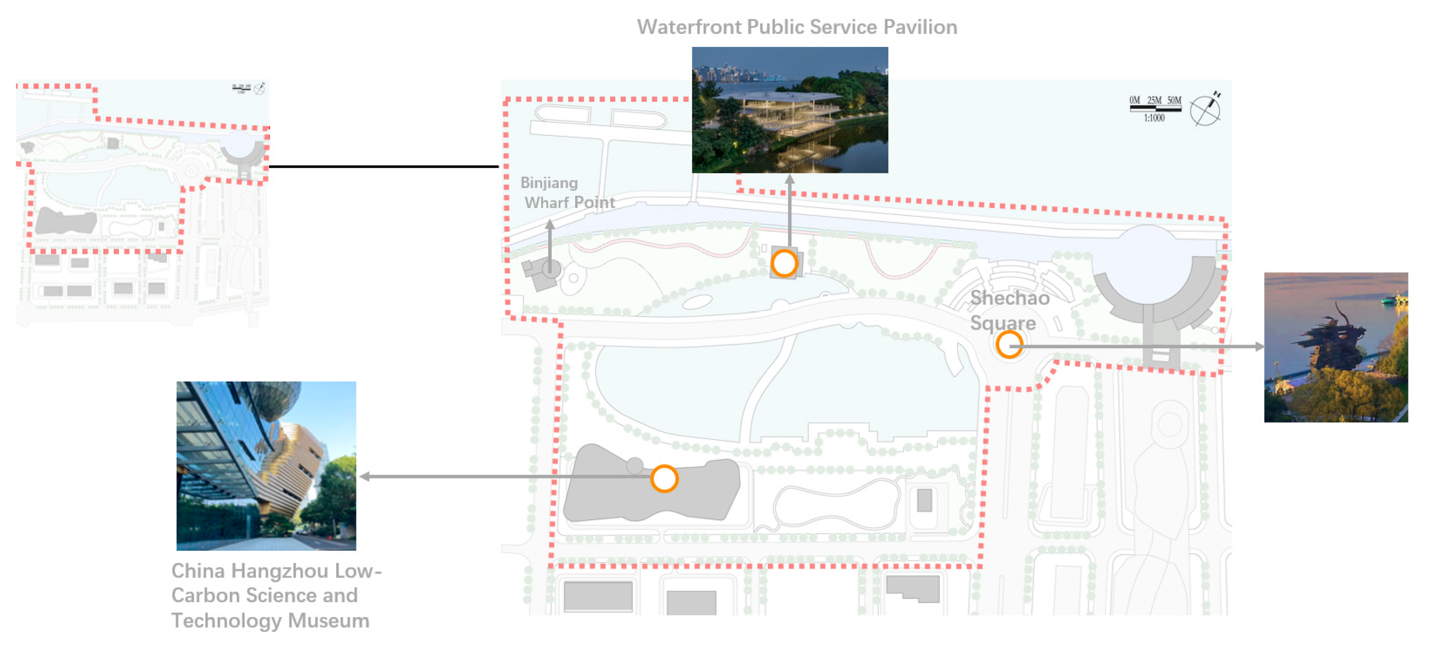
Secondly, another key node along the SBQR is the Shechao Square (Zone B), which has become a key tourist destination and a social public space for both residents and visitors along the SBQR. It key public places include the Shechao sculpture, Jianshi Waterfront Public Service Pavilion, China Hangzhou Low-Carbon Science and Technology Museum and Binjiang wharf (see Figure 9).
Figure 8.
Spatial distribution of key nodes in Zone A (Source: drawing by author).
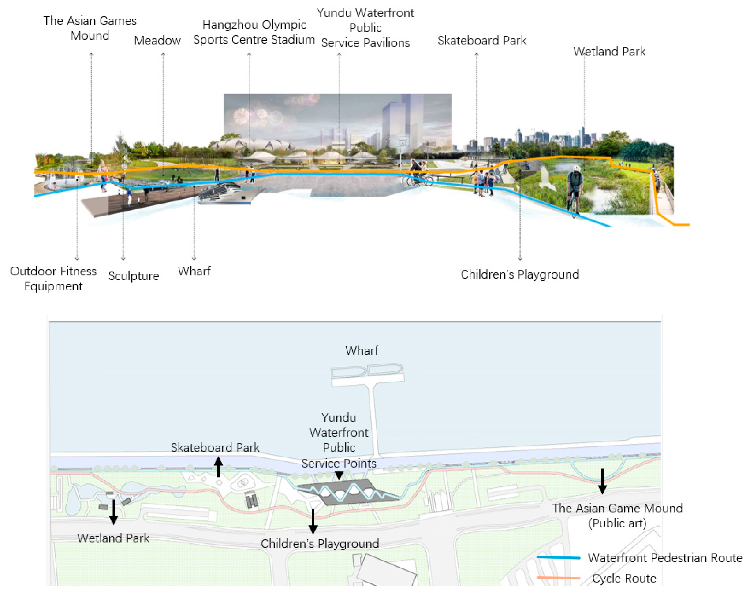
Figure 9.
Spatial distribution of key nodes in Zone B (Source: drawing by author).
3.2. Mixed Method Design
This study adopts a mixed methods research design to examine how users’ perceptions and preferences influence the improvement of urban waterfront open space quality in newly developed zones shaped by mega-event-led regeneration in Hangzhou, China. For quantitative method, two sets of online questionnaires were distributed in each selected area to quantify the users’ perceptions towards urban waterfront open spaces: one measuring the perceived importance of each sub-sub factors based on establishing assessment framework, and the other assessing satisfaction with the same set of variables. For qualitative method, direct observation was undertaken to analyse how end-users use these newly built waterfront open spaces.
3.3. Data Collection and Analysis
3.3.1. Data Collection and Analysis of the Online Questionnaires Survey
In terms of data collection for the online questionnaire survey, determining an appropriate sample size was the primary academic concern at the initial stage [65]. This study adopts Cochran’s [66] sample size formula to calculate the required sample size. The equation proposed by Cochran is shown below:
where n0= initial sample size (for an infinite population); Z2= the area under the acceptance region in a normal distribution. It is commonly set at 1.96 (Z) for a 95% confidence level, as this confidence level is frequently used within the specified margin of error. P= estimated proportion of the population with the characteristic of interest (commonly set at 0.5 if unknown, as it maximizes the required sample size); E= the preferred level of precision (researchers usually set the level of acceptable error at 5%). By carrying out the equation: N = 1.962 * 0.5 * (1-0.5) / (0.05)2 = 384.16. Therefore, this study includes a total of 770 questionnaires, consisting of 385 importance-based questionnaires and 385 satisfaction-based questionnaires.
The online questionnaire survey was conducted from June 2024 to October 2024, which involved four steps. First, an online questionnaire was created using Wenjuanxing, a software tool that generates a live link for accessing the survey. Second, an email invitation was sent to representatives of communities along the core section of the Qiantang River in the Binjiang Development Zone. These potential participants (community representatives) were asked to forward a “call for participants” letter to others who had visited the selected areas. The letter outlined the purpose of the research, the estimated completion time, relevant policies and included an access link. Regarding research ethics, the research procedures adopted in this study were approved by the Research Committee of the University of Nottingham.
The final questionnaire was then distributed to end-users, and the main components included: (1) demographic information (gender, age range, and current status); (2) general questions regarding space-in-use variables (frequency of visits, number of visits, and duration of stay) (Ouyang & Wu, 2023); and (3) ratings of the importance and satisfaction of criteria related to the qualities of urban waterfront open spaces were measured using a five-point Likert scale. For the importance-based questionnaire, scores ranged from 1 (“not at all important”) to 5 (“very important”), while for the satisfaction-based questionnaire, responses ranged from 1 (“very dissatisfied”) to 5 (“very satisfied”).
In terms of data analysis, IBM SPSS Statistics (version 30.0) was employed to calculate the reliability and validity based on the results of Cronbach’s Alpha value and the KMO values. This study of data analysis followed by ranking the mean score, standard deviation and mapping the Importance–Performance Analysis (IPA) method that was first proposed by Martilla and James [67]. It is an effective method that graphically represents the relationship between importance and performance for a set of attributes and items in a plot and interprets the results of user experience questionnaires. The level of perceived importance of each item influencing the quality of urban waterfront open spaces and the spaces’ performance level are displayed in an IPA plot (Figure 10) and are classified into four quadrants or categories [67].
- Quadrant 1(Q1): Q1 is entitled “Keep up the good work”, which reflects both higher performance and higher importance for the attributes/items [68]. Therefore, attributes/items positioned in Q1 can be viewed as the major strengths and potential competitive advantages of the selected area. This would suggest there is no need to improve these attributes, and the current action strategies should be maintained
- Quadrant 2(Q2): Q2 is labelled “possible overkill”. Attributes/items in Q2 display a higher performance within a lower importance, which suggests focusing on them may waste limited resources
- Quadrant 3(Q3): Q3 referred to as “Low Priority”. Attributes/items positioned in Q3 have lower importance and lower performance, reflecting minor weaknesses in the qualities of urban waterfront open spaces
- Quadrant 4(Q4): Q4 is termed “Concentrate Here”. Attributes/items positioned in Q4 were characterised by higher importance with relatively lower performance, identifying the priority for improving the quality of urban waterfront open space.
3.3.2. Data Collection and Analysis of the Direct Observation
Direct field observation is a qualitative research method used to understand how people interact with and use a given space by systematically tracking their behaviours in time and space [69]. In this study, non-participation direct field observation was used to understand the local context and overall qualities of urban waterfront open spaces. Because of the large scale of the selected areas, two stages of observations were carried out: grand-tour observations and mini-tour observations [70]. The grand-tour observations were conducted to document the general spatial characteristics and physical configurations of the case study areas. This stage involved taking photographs and recording observations of the physical environment, including architectural facades, urban furniture, active frontages and natural landscapes during walk-through observations in July 2024. In this second phase, the two key nodes were further investigated based on the spatial analysis shown in Table 9. This stage of direct observation was conducted on both weekdays (Mondays) and weekends during June and September 2024.
4. Results
A total of 770 participants completed both the importance-level and satisfaction-level online questionnaires at SBQR (see Table 8). Male participants comprised a higher proportion than female, at 57.1% (n = 440) and 41.0% (n = 316) of the total sample respectively. The dominant age group was 25–39 years old (37.7%), followed by those aged 40–59 (28.6%); participants aged 60 and above accounted for 16.3%, while those aged 18–24 made up 13.4% (approximately 4% of respondents chose not to disclose their age). The majority were visitors (43.6%) and residents (42.3%), with designers (5.3%) and managers (6.2%) comprising smaller portions of the sample.
Table 9 illustrates the spatial use variables of participants at SBQR. The highest proportion of respondents reported visiting SBQR several times a week (20.0%), followed by those who visited several times a year (18.6%) and once a year (15.6%). Only a small proportion reported visiting occasionally (6.2%) or once a month (4.2%). 43.5% of respondents had visited the park 7–10 times, suggesting a relatively high level of engagement during the sampling period. Meanwhile, 33% of users had visited only 1–3 times. As for dwell time, over 60% of participants (63%) reported staying in the urban waterfront open spaces for more than one hour.

Table 9.
Space in use at SBQR based on questionnaire survey.
| Space use variables at SBQR | Number | Percentage % (n=770) |
|---|---|---|
| Visit frequency | ||
| Every day | 60 | 7.8 |
| Several times a week | 154 | 20.0 |
| Once a week | 96 | 12.5 |
| Several times a month | 116 | 15.1 |
| Once a month | 32 | 4.2 |
| Several times a year | 143 | 18.6 |
| Once a year | 121 | 15.6 |
| Occasionally | 48 | 6.2 |
| Number of visits | ||
| 1-3 times | 254 | 33 |
| 4-6 times | 181 | 23.5 |
| 7-10 times | 335 | 43.5 |
| Dwell Time | ||
| <30mins | 182 | 23.6 |
| 30-60mins | 103 | 13.4 |
| 1-2 hours | 289 | 37.5 |
| >2 hours | 196 | 25.5 |
In terms of the main motivations for visiting the SBQR, physical exercise accounts for the highest proportion (23.9%), followed by socialising (18.1%) and leisure (17.6%), whereas commuting (11.5%) and work/study (10.5%) represent smaller proportions (see Figure 11).
Regarding activity patterns, Figure 12 shows that although physical exercise and recreational activities, such as enjoying natural scenery (n = 565) and walking (n = 469), are the two most popular activities, participation in cultural activities remains relatively limited. For instance, only 172 respondents reported visiting museums, and 299 indicated that they had attended public art exhibitions. This suggests that cultural venues along the SBQR are not well integrated into everyday life. Nevertheless, the urban waterfront open spaces along the SBQR are convenient for social interaction, with many respondents indicating that they meet neighbours (n = 418) or friends (n = 414) in the area. Leisure activities, such as listening to music (n = 415) and dining at restaurants (n = 416), also show high levels of participation.
Regarding the mean score of dimensions of urban waterfront open space quality,inclusiveness was among the top important dimensions, whereas spatial aesthetics ranked the lowest (see Figure 13). Although the importance level of place identity ranks fifth, its mean score exceeds 3.80, indicating that the intangible legacies of the Asian Games have the potential to create a distinctive new urban image, even in the absence of tangible heritage resources.
In terms of mapping the IPA scatter plots, the evaluation of importance and satisfaction helps identify priorities for enhancing the quality of urban waterfront open spaces. Building upon this, future waterfront regeneration policies and design principles can be developed from the users’ perspective.
For access and linkage dimension, “accessibility of water’s edge” (A10), “physical accessibility of basic public service facilities” (A11), “physical accessibility of cultural venues” (A14) and “the effective connection between pedestrian bridges and key nodes” (A1) are all positioned in the high-importance but low-satisfaction quadrant (see Figure 14). This indicates urgent issues to prioritise that need to be resolved in the development of urban waterfront open spaces along the core section of SBQR.
For safety, the “provision of personalising decorations” (B12) as key natural surveillance, such as displaying pictures, plants, and small-scale public artworks, is a priority for improving the sense of safety and security. In addition, traffic-related safety measures (B5, B6, B7), sufficient night-time lighting quality (B11), integrating blue–green infrastructure to improve climate-resilient flooding management (B2, B4), and “good maintenance and cleanliness” (B13) are positioned within the high-importance, high-satisfaction quadrant at both sites, indicating a high-performance level (see Figure 15).
In terms of comfort, “provision of artificial shelter from wind, rain and sun” (C4), “A variety of formal and informal seating options” (C5), “low noise level during seating and resting” (C7), “materials for seats with insulating and water-repellent properties” (C11), and “view of clear visual axis” (C22) have been identified as key variables located within the high-importance but low-performance quadrant, indicating priority areas for future waterfront design interventions (See Figure 16).
Regarding spatial aesthetic, “the appropriate scale of cultural venues” (D3), “the appropriate scale of residential blocks (D4) and “the rhythm of active frontages at the ground floor level” (D13) are the three key elements that need to be improved in advance (see Figure 17). The active frontage in this study refers to the creation of engaging interfaces through transparent display windows and visible indoor activities that enable social interaction at the boundary between the public realm of the waterfront street and the interior of the building [20]. As Kickert [71] points out, a well-designed active frontage should meet three key criteria: physical transparency (allowing passers-by to see into the premises), functional permeability (providing functional reasons for them to enter) and perceptual hospitality (creating a welcoming atmosphere that invites people into the premises). Such good active frontages should not appear sporadically on individual waterfront buildings but rather be co-ordinated to establish a coherent rhythm along the entire waterfront edge.
In terms of place identity, Figure 18 demonstrates a wider distribution of items within the priority improvement areas, such as the distinctiveness of “decorative elements” (E2), “outdoor elevated walkways” (E7), “transit shelters” (E11), “banners/digital billboards” (E12), “lampposts” (E14), “water features” (E15 and E16), “monuments” (E17), “historic preservation and the adaptive re-use of existing built form as an embodiment of collective memory” (E22), as well as “cultural and digital heritage interpretation and presentation” (E23). This indicates that the distinctive physical configuration of urban waterfront open spaces in the new district has not yet been closely associated with local cultural and symbolic meanings. In other words, the weak connection between people and place, due to the insufficient integration of iconic and symbolic elements within key nodes along the waterfront, has resulted in a diminished sense of place attachment. Furthermore, although newly developed zones may lack formally recognised architectural heritage and their existing buildings are not listed as official heritage sites, certain key public buildings, especially those rooted in collective memory or local meaning to residents, should also be preserved and adaptively re-used that respond to contemporary human demands. This area also lacks digital technology to express complete historical narrative and historical events related to heritage and tidal-flood resistance in the public realm of urban waterfront.
Regarding inclusiveness, this area encounters some key inclusiveness-related challenges, including “variety in age” (F1), “the length of social interaction” (F16), and “public–private collaboration” (F19) (see Figure 19). Furthermore, the improvement measures identified as priorities for case study include the free use of “movable benches” (F13) and the provision of “flexible spaces accessible to all social groups” (F15). The provision of movement street furniture and flexible spaces tends to accommodate diverse use and continual adjustment over time, thereby encouraging more social encounters [20,26]. In this context, future waterfront regeneration polices in this area tend to incorporate age-friendly design principles to tackle the current low-frequency use condition for older adults, including the provision of both vertical and horizontal barrier-free facilities, as well as the creation of soft edges of dynamic activity zones and static rest areas. Secondly, it is highly recommended to introduce a variety of temporary and seasonal activities, such as street performances, temporary thematic markets and small-scale cultural festivals, alongside the use of flexible street furniture and flexible spaces in the local waterfront community scale. To compensate for the limitations of top-down waterfront regeneration strategies, a bottom-up approach to micro-regeneration should be adopted to encourage users to actively participate in the decision-making process.
5. Discussion
5.1. Integrating Waterfront Route Systems with Their Urban Surroundings to Encourage Both Active and Passive Engagement with the Water
At the contemporary waterfront connectivity development programmes along the SBQR, the primary objective was to identify the breakpoints and improve the connectivity of fragmented plots along the water’s edge. In other words, the initial phase of waterfront regeneration in case study primarily emphasised enhancing public accessibility of water and re-linking the urban waterfront areas and their hinterland by integrating the waterfront open spaces with their urban contexts and adjacent water bodies. Therefore, establishing three-level slow-mobility circulation system including walking, jogging, and cycling (see Figure 20) complemented by welcoming entrances and effective wayfinding signage along the core section of SBQR has become a key waterfront design principle to shape continuous waterfront pedestrian pathways in case study.
However, direct observations indicate that users are usually positioned as passive observers, with limited opportunities for multisensory waterfront experiences (see Figure 21).
Some macro-level design principles intended to encourage both active and passive water engagement, such as establishing waterfront pedestrian bridges to improve new cross-water links and adding water platforms, are challenging to implement along the SBQR due to flooding risks and financial constraints. In this context, introducing temporary water-related design installations, developed in collaboration with local artists and integrated into existing daily routes, is key to enhancing water engagement and multisensory waterfront experiences [55]. In addition, direct observations reveal that physical fencing has been introduced at key access nodes and walking promenades as a measure to regulate and restrict motor-vehicle access (see Figure 22). This highlights how the misalignment between space in use and long-term management strategies has become a key challenge to achieving improved continuity and connectivity following the completion and implementation of the urban waterfront connectivity programme.
5.2. Encouraging Soft Surveillance Rather than Artificial Surveillance
Based on the qualitative and quantitative results, this study suggests that artificial surveillance, including provision of CCTV cameras and security personnel, has limited effectiveness in enhancing users’ sense of safety, reflected in the low importance ratings for both surveillance camera provision (M = 3.58) and the number of public/private guards and police (M = 3.38). Direct observation also reveals low intensity and frequency of activity levels in areas with high CCTV density.
By contrast, encouraging soft surveillance, such as the provision of personalised decorative elements, received a higher importance rating (M = 4.01). This result aligns with Jacobs’ “eyes on the street” approach, which highlights the role of a street’s “natural proprietors” and people in movement to improve a sense of safety. She argued that the public realm should be self-policing rather than overly securitized [72]. Such natural surveillance could be developed through combining physical design into spaces, for instance designing daily routes that encourage public use and ensuring that property within public spaces is oriented to promote visibility. Carmona [15,60] also recognised that the presence of policing and over-securitisation can make the public space perceptibly uncomfortable. They highlighted the importance of personalising decorative elements, through the presence of streetlights, private plantings or yard decorations, in shaping a sense of safety.
5.3. Adding Primary and Secondary Seating with Shelters to Encourage Longer Stay and Social Encounter
Analysing the importance and satisfaction mean scores for comfort, the key finding is that the case study area tends to lack an integration of primary and secondary seating options, which may reduce users’ range of optional activities and limit the flexibility needed to accommodate spontaneous and temporary uses. The direct observation also indicates that combinations primary and secondary seating can effectively facilitate social interaction and spontaneous social activities. Particularly some certain social activities, such as outdoor live streaming dominated by young people and community choir performances (see Figure 23) by the elderly, often attract large crowds, who tend to gather on the steps or within the bridge undercroft facing the water between 7:00 pm and 9:00 pm. In future urban waterfront design practices, primary seating types such as city benches, freestanding chairs, or café chairs should be embedded within secondary seating options in high activity areas, where users can sit and rest on elements such as pedestals, steps, stones, or even the ground itself.
5.4. The Low Level of Usage in Active Frontages
Analysing the importance and satisfaction mean scores for spatial aesthetics and direct observation, the key finding shows that existing rhythm of active frontages at ground floor mainly supports short-term and temporary activities due to the lack of cultural and retail facilities to support everyday life. More specifically, instead of small-scale incremental development and micro-regeneration, large-scale demolition has been implemented since 2021, to develop a leisure and entertainment environment suitable to meet the demands of international urban competition. In terms of the design process, instead of preserving and refurbishing historic buildings, their absence in this area has allowed the demolition of most waterfront buildings, to be replaced by similar high-rise buildings, hierarchical road systems and enclosed urban residential blocks, characterised by a lack of active or interactive frontages, while maintaining a uniform facade treatment with glass curtain walls.
5.5. Relies on Mega-Event Legacies to Reshape Collective Memory
Collective memory, as an essential form of intangible social heritage that develops alongside end-users’ lifetimes, plays a key role in the placemaking process. Urban waterfront open spaces, as key vessels for triggering collective memory, should not focus solely on physical restorations; rather, they must be reconfigured as “geographies of memory” [73] (p. 8), thereby becoming essential nodes for enhancing public life and facilitating community participation.
Activities and historical events as reminders of collective memories along with intangible heritage values such as oral traditions, performing arts, social practices, rituals and the knowledge and skills necessary for producing traditional crafts and cultural products, can also be interpreted and displayed through the application of digital technologies, such as 3D reconstruction and VR interaction [74]. These digital technologies aim to enrich users’ multisensory experiences, reshape collective memory and thus boost active, interactive engagement with intangible mega event legacies.
In addition, cultural branding could be incorporated into current event-led regeneration agenda to create public value and collective memory on the urban waterfront for both residents and visitors. This form of cultural branding can be achieved through the organisation of seasonal cultural events and public art, while also encouraging cooperative governance among various stakeholders [74]. Such an approach also reflects the premise that the shaping of a sense of locality is socially produced, its meaning being derived from everyday experiences and perceptual interpretations. Additionally, the newly developed waterfront demonstrates that legacies of the Asian Games in Hangzhou have the potential to create a distinctive and new urban image, even without tangible heritage resources.
5.6. Relaxed Management Practices and Community Engagement
In terms of inclusiveness, although these waterfront public spaces are physically accessible to everyone, the provision of sports facilities and the layout of cycling routes along the waterfront primarily cater to younger groups, thus failing to adequately incorporate the needs of older adults, who are partially marginalised as a result. Another key finding is that the creation of point-based waterfront service pavilions along the linear waterfronts has been one of the major regeneration projects in this area. These pavilions, positioned at intervals ranging from approximately 200 to 1,000 metres, mainly accommodate coffee shops, exhibition spaces and other public service functions. Nevertheless, existing urban waterfront public service pavilions are not open 24/7, which would be desirable, and they fail to meet some important day-to-day requirements of residents and visitors, such as first-aid supplies, access to drinking water or temporary storage. These shortcomings can be traced back to the design stage, where the everyday demands of users, particularly those of marginalised groups, were neither systematically collected nor adequately reflected in the planning and decision-making process. This circumstance indicates that participatory planning in China remains at an embryonic stage, which in turn creates conditions under which culture-led regeneration may result in gentrification.
Furthermore, unlike previous models of bottom-up urban governance in Western countries, the new round of urban waterfront regeneration in China has implemented the “Street Planner System” as a new participatory planning by using the newly created waterfront public service pavilion. Although this approach is still led by the local state, but features co-design and cooperation including residents, local community representatives and urban designers and planners from the local government. Its aim is to encourage public consultation. However, the result shows that the level of public participation remains limited, particularly among older adults, who find it challenging to be involved in the decision-making processes of urban waterfront connectivity projects.
In terms of relaxed management, the control practices of security personnel reflect the exercise of “soft power” in their policing of the two selected sites. When addressing certain restricted behaviours, such as dog walking or street performances continuing beyond 9:00 p.m., the security personnel operated without resorting to outright coercive measures. Instead, they employed more soft and relaxed management practices to control activities and behaviours, thereby increasing inclusivity.
6. Conclusions
In conclusion, this study investigated users’ perceptions of urban waterfront open spaces reshaped through event-led regeneration in newly developed waterfront areas along the SBQR in Hangzhou. It further discusses how the socio-spatial qualities of these spaces could be enhanced based on users’ perceptions and attitudes.
To support and develop a place-based and people-centred approach, an integrated assessment framework for evaluating the quality of urban waterfront open spaces was established to identify end-user demands and inform future policies based on placemaking theory, which includes six key factors, 21 sub-factors and 110 sub-sub-factors. Compared with previous assessment frameworks for evaluating publicness and public space quality, this framework considers the socio-spatial characteristics of public places on urban waterfronts and establishes a three-level evaluation system. Most importantly, it links the relationship between the mega-event-led regeneration and urban waterfront open spaces in the Chinese context.
Unlike historical urban waterfront areas that embrace rich heritage resources, public places in newly built areas may lack tangible heritage buildings and the associated heritage conservation approaches. Nevertheless, post-Olympic legacies, whether in the form of intangible symbolic meanings or tangible cultural flagships and sports facilities, have the potential to facilitate placemaking and initiate a new narrative within a people-centred vision of waterfront regeneration.
In the case of urban waterfront open spaces along the SBQR in Hangzhou, the development approach remains situated within traditional top-down urban planning, while human needs and participatory planning have begun to emerge as initial experimental steps in waterfront placemaking practice. Therefore, examining the existing physical configuration of waterfront open spaces and discussing core themes in relation to the six key dimensions of access and linkage, safety, comfort, spatial aesthetics, place identity, and inclusiveness become essential for future waterfront regeneration. Among the variables, elements for supporting people’s daily life, encouraging water engagement, developing natural surveillance, facilitating public participation in decision-making process and shaping collective memory through use of digital technologies received high importance ratings.
Furthermore, such sports mega-events in Hangzhou can be leveraged to achieve physical improvements that would not occur automatically as a result of hosting the event itself. Looking ahead, an essential task is to reorient existing waterfront infrastructure toward the needs of all social groups and to integrate it into the daily routes, practices and rhythms of local residents.
There are several limitations in this study that could be addressed in future research. First, the established assessment framework could be further refined through the application of factor analysis methods to determine an appropriate evaluation indicator system, such as Exploratory Factor Analysis (EFA) and Confirmatory Factor Analysis (CFA). Furthermore, the case study could be extended beyond the Chinese context to include international cases, allowing for comparisons between historical urban waterfront areas in old city centres and newly developed waterfront districts.
Author Contributions
Conceptualization, Z.S.; methodology, Z.S. and J.Z; investigation, formal analysis, Z.S; writing—original draft preparation, Z.S; writing—review and editing, Z.S; Supervision, Y.T. All authors have read and agreed to the published version of the manuscript.
Funding
The authors received no financial support for the research, authorship, and/or publication of this article.
Data Availability Statement
The data presented in this study are available on request from the corresponding author.
Conflicts of Interest
The authors declare no conflicts of interest.
Appendix A
Appendix A.1
Table A1.
Reliability and validity test based on the importance-based and satisfaction-based online questionnaires.
Table A1.
Reliability and validity test based on the importance-based and satisfaction-based online questionnaires.
| Index of importance level |
Cronbach’s Alpha>0.7 | Bartlett Sig. Standard<0.05 |
KMO Standard>0.8 |
Number of variables |
|---|---|---|---|---|
| Access and linkage | 0.944 | 0.000 | 0.933 | 15 |
| Safety | 0.938 | 0.000 | 0.931 | 13 |
| Comfort | 0.972 | 0.000 | 0.971 | 27 |
| Spatial aesthetics | 0.922 | 0.000 | 0.965 | 13 |
| Place identity | 0.963 | 0.000 | 0.962 | 23 |
| Inclusiveness | 0.969 | 0.000 | 0.976 | 19 |
| All sub-sub-factors | 0.992 | 0.000 | 0.966 | 110 |
| Index of satisfaction level |
Cronbach’s Alpha>0.7 | Bartlett Sig. Standard<0.05 |
KMO Standard>0.8 |
Number of variables |
| Access and linkage | 0.946 | 0.000 | 0.961 | 15 |
| Safety | 0.942 | 0.000 | 0.966 | 13 |
| Comfort | 0.968 | 0.000 | 0.977 | 27 |
| Spatial aesthetics | 0.931 | 0.000 | 0.954 | 13 |
| Place identity | 0.960 | 0.000 | 0.975 | 23 |
| Inclusiveness | 0.949 | 0.000 | 0.967 | 19 |
| All sub-sub-factors | 0.991 | 0.000 | 0.978 | 110 |
Table A2.
The result of online questionnaire.
| Variables | Importance Mean | Rank importance level |
Satisfaction Mean |
Rank satisfaction level |
|---|---|---|---|---|
| A1 | 4.00 | 5 | 3.40 | 15 |
| A2 | 4.09 | 1 | 3.78 | 4 |
| A3 | 3.75 | 10 | 3.83 | 2 |
| A4 | 3.83 | 9 | 3.72 | 7 |
| A5 | 3.56 | 14 | 3.66 | 9 |
| A6 | 4.08 | 2 | 3.85 | 1 |
| A7 | 3.99 | 6 | 3.79 | 3 |
| A8 | 3.58 | 12 | 3.72 | 8 |
| A9 | 3.98 | 8 | 3.74 | 6 |
| A10 | 4.05 | 3 | 3.76 | 5 |
| A11 | 3.99 | 7 | 3.54 | 12 |
| A12 | 3.55 | 15 | 3.61 | 10 |
| A13 | 3.59 | 11 | 3.53 | 13 |
| A14 | 4.03 | 4 | 3.48 | 14 |
| A15 | 3.57 | 13 | 3.55 | 11 |
| B1 | 3.39 | 12 | 3.73 | 9 |
| B2 | 3.99 | 5 | 3.83 | 2 |
| B3 | 3.95 | 7 | 3.80 | 3 |
| B4 | 4.00 | 4 | 3.74 | 7 |
| B5 | 4.01 | 2 | 3.84 | 1 |
| B6 | 3.96 | 6 | 3.79 | 4 |
| B7 | 3.93 | 8 | 3.76 | 6 |
| B8 | 3.64 | 10 | 3.72 | 10 |
| B9 | 3.58 | 11 | 3.79 | 5 |
| B10 | 3.38 | 13 | 3.72 | 11 |
| B11 | 4.04 | 1 | 3.70 | 12 |
| B12 | 4.01 | 3 | 3.57 | 13 |
| B13 | 3.90 | 9 | 3.74 | 8 |
| C1 | 3.99 | 15 | 3.84 | 1 |
| C2 | 3.55 | 26 | 3.62 | 17 |
| C3 | 3.75 | 19 | 3.56 | 22 |
| C4 | 4.05 | 3 | 3.44 | 26 |
| C5 | 4.04 | 7 | 3.44 | 27 |
| C6 | 4.06 | 2 | 3.59 | 20 |
| C7 | 4.04 | 8 | 3.53 | 23 |
| C8 | 3.96 | 17 | 3.67 | 12 |
| C9 | 3.98 | 16 | 3.69 | 10 |
| C10 | 4.04 | 9 | 3.71 | 8 |
| C11 | 3.70 | 22 | 3.59 | 21 |
| C12 | 4.05 | 4 | 3.68 | 11 |
| C13 | 3.70 | 22 | 3.74 | 5 |
| C14 | 4.03 | 12 | 3.77 | 3 |
| C15 | 3.91 | 18 | 3.73 | 6 |
| C16 | 4.04 | 10 | 3.75 | 4 |
| C17 | 4.05 | 5 | 3.79 | 2 |
| C18 | 3.58 | 25 | 3.65 | 16 |
| C19 | 3.59 | 24 | 3.52 | 24 |
| C20 | 3.19 | 27 | 3.66 | 14 |
| C21 | 3.75 | 20 | 3.61 | 18 |
| C22 | 4.00 | 14 | 3.66 | 15 |
| C23 | 4.04 | 11 | 3.67 | 13 |
| C24 | 4.08 | 1 | 3.71 | 9 |
| C25 | 4.05 | 6 | 3.72 | 7 |
| C26 | 3.71 | 21 | 3.60 | 19 |
| C27 | 4.03 | 13 | 3.47 | 25 |
| D1 | 3.73 | 8 | 3.42 | 13 |
| D2 | 3.98 | 2 | 3.74 | 1 |
| D3 | 3.91 | 6 | 3.58 | 7 |
| D4 | 3.96 | 3 | 3.56 | 8 |
| D5 | 3.26 | 13 | 3.60 | 5 |
| D6 | 3.72 | 9 | 3.59 | 6 |
| D7 | 3.53 | 10 | 3.54 | 9 |
| D8 | 4.01 | 1 | 3.64 | 3 |
| D9 | 3.93 | 5 | 3.65 | 2 |
| D10 | 3.33 | 11 | 3.45 | 11 |
| D11 | 3.90 | 7 | 3.64 | 4 |
| D12 | 3.29 | 12 | 3.45 | 12 |
| D13 | 3.94 | 4 | 3.46 | 10 |
| E1 | 3.68 | 18 | 3.62 | 4 |
| E2 | 3.98 | 6 | 3.54 | 12 |
| E3 | 3.50 | 21 | 3.65 | 1 |
| E4 | 3.98 | 7 | 3.56 | 9 |
| E5 | 4.01 | 3 | 3.62 | 5 |
| E6 | 3.30 | 22 | 3.56 | 10 |
| E7 | 3.84 | 17 | 3.52 | 14 |
| E8 | 3.98 | 8 | 3.63 | 2 |
| E9 | 3.53 | 20 | 3.61 | 7 |
| E10 | 3.61 | 19 | 3.63 | 3 |
| E11 | 3.88 | 15 | 3.50 | 16 |
| E12 | 3.89 | 14 | 3.53 | 13 |
| E13 | 3.11 | 23 | 3.37 | 23 |
| E14 | 3.92 | 13 | 3.50 | 17 |
| E15 | 4.03 | 1 | 3.49 | 20 |
| E16 | 4.02 | 2 | 3.39 | 22 |
| E17 | 3.98 | 9 | 3.42 | 21 |
| E18 | 3.99 | 5 | 3.62 | 6 |
| E19 | 4.00 | 4 | 3.50 | 8 |
| E20 | 3.98 | 10 | 3.59 | 11 |
| E21 | 3.96 | 12 | 3.55 | 15 |
| E22 | 3.97 | 11 | 3.51 | 18 |
| E23 | 3.85 | 16 | 3.50 | 19 |
| F1 | 3.99 | 9 | 3.60 | 10 |
| F2 | 4.01 | 7 | 3.69 | 2 |
| F3 | 3.95 | 14 | 3.70 | 1 |
| F4 | 4.01 | 8 | 3.69 | 3 |
| F5 | 3.69 | 19 | 3.62 | 11 |
| F6 | 4.04 | 3 | 3.64 | 6 |
| F7 | 4.04 | 4 | 3.67 | 8 |
| F8 | 3.73 | 16 | 3.52 | 17 |
| F9 | 4.04 | 5 | 3.62 | 12 |
| F10 | 3.72 | 17 | 3.65 | 4 |
| F11 | 4.06 | 2 | 3.64 | 7 |
| F12 | 4.02 | 6 | 3.67 | 9 |
| F13 | 3.99 | 10 | 3.56 | 15 |
| F14 | 3.74 | 15 | 3.47 | 19 |
| F15 | 3.97 | 12 | 3.53 | 16 |
| F16 | 4.07 | 1 | 3.51 | 18 |
| F17 | 3.71 | 18 | 3.57 | 13 |
| F18 | 3.96 | 13 | 3.65 | 5 |
| F19 | 3.98 | 11 | 3.57 | 14 |
References
References
- Smith, H.; Ferrari, M.S.G. Negotiating City-Building in Waterfront Communities Around the North Sea. In Waterfront Regeneration: Experiences in City-Building; Smith, H., Ferrari, M.S.G., Eds.; Routledge: London, UK, 2012; pp. 17–32. [CrossRef]
- Evans, C.; Harris, M.S.; Taufen, A.; Livesley, S.J.; Crommelin, L. What Does It Mean for a Transitioning Urban Waterfront to “Work” from a Sustainability Perspective? Journal of Urbanism: International Research on Placemaking and Urban Sustainability 2025, 18(3), 349–372. [CrossRef]
- Jones, A.L. Regenerating Urban Waterfronts—Creating Better Futures—From Commercial and Leisure Market Places to Cultural Quarters and Innovation Districts. Planning Practice & Research 2017, 32(3), 333–344. [CrossRef]
- Lehrer, U.; Laidley, J. Old Mega-Projects Newly Packaged? Waterfront Redevelopment in Toronto. International Journal of Urban and Regional Research 2008, 32(4), 786–803. [CrossRef]
- Evans, G. Measure for Measure: Evaluating the Evidence of Culture’s Contribution to Regeneration. Urban Studies 2005, 42(5–6), 959–983. [CrossRef]
- Gunay, Z.; Dokmeci, V. Culture-Led Regeneration of Istanbul Waterfront: Golden Horn Cultural Valley Project. Cities 2012, 29(4), 213–222. [CrossRef]
- Shao, Z.; Tang, Y. Canal-Orientated Urban Waterfront Regeneration Based on the Concept of Everyday Heritage: A Case Study in Suzhou, China. Archit. MPS 2025, 30, 2. [CrossRef]
- Doucet, B.; Van Kempen, R.; Van Weesep, J. Resident Perceptions of Flagship Waterfront Regeneration: The Case of the Kop van Zuid in Rotterdam. Tijdschrift voor Economische en Sociale Geografie 2011, 102(2), 125–145. [CrossRef]
- Wang, K. Temporal Insights into Mega-Events and Waterfront Industrial Heritage Transformation: A Case Study of Shanghai’s Huangpu River Industrial Zone. Built Heritage 2024, 8(1), 48. [CrossRef]
- Zhang, M. The State-Led Approach to Industrial Heritage in China’s Mega-Events: Capital Accumulation, Urban Regeneration, and Heritage Preservation. Built Heritage 2024, 8(1), 30. [CrossRef]
- Jones, Z.M.; Ponzini, D. Mega-Events and the Preservation of Urban Heritage: Literature Gaps, Potential Overlaps, and a Call for Further Research. Journal of Planning Literature 2018, 33(4), 433–450. [CrossRef]
- Liu, S.; Lai, S.Q. Study on the Influencing Factors of Urban Public Space Vitality Based on Multi-Source Data: A Case Study of the Huangpu River Waterfront in Shanghai. Landscape Architecture 2021, 28(3), 75–81. (In Chinese).
- Rapoport, A. Perception of Environmental Quality—Environmental Evaluation and Preference. In Human Aspects of Urban Form: Towards a Man–Environment Approach to Urban Form and Design; Elsevier: Amsterdam, The Netherlands, 2013; pp. 48–100.
- Madanipour, A. Why Are the Design and Development of Public Spaces Significant for Cities? Environment and Planning B: Planning and Design 1999, 26(6), 879–891. [CrossRef]
- Carmona, M. Contemporary Public Space: Critique and Classification, Part One: Critique. Journal of Urban Design 2010, 15(1), 123–148. [CrossRef]
- Relph, E. Place and Placelessness; Pion: London, UK, 1976; pp. 100–118.
- Montgomery, J. Making a City: Urbanity, Vitality and Urban Design. Journal of Urban Design 1998, 3(1), 93–116. [CrossRef]
- Friedmann, J. Place and Place-Making in Cities: A Global Perspective. Planning Theory & Practice 2010, 11(2), 149–165. [CrossRef]
- Buckman, S. Canal-Oriented Development as Waterfront Place-Making: An Analysis of the Built Form. Journal of Urban Design 2016, 21(6), 785–801. [CrossRef]
- Gehl, Jan. Cities for People / Jan Gehl. London, Island Press, 2010; pp. 232-239.
- Carmona, M. The Place-Shaping Continuum: A Theory of Urban Design Process. Journal of Urban Design 2014, 19(1), 2–36. [CrossRef]
- Lang, J. Comments on ‘The Place-Shaping Continuum: A Theory of Urban Design Process’. Journal of Urban Design 2014, 19(1), 41–43. [CrossRef]
- Anderson, A.; Law, L. Putting Carmona’s Place-Shaping Continuum to Use in Research Practice. Journal of Urban Design 2015, 20(5), 545–562. [CrossRef]
- Fageir, M.; Porter, N.; Borsi, K. Contested Grounds: The Regeneration of Liverpool Waterfront. Planning Perspectives 2021, 36(3), 535–557. [CrossRef]
- Gordon, D.L. Planning, Design and Managing Change in Urban Waterfront Redevelopment. Town Planning Review 1996, 67(3), 261–290. [CrossRef]
- Sepe, M. Urban History and Cultural Resources in Urban Regeneration: A Case of Creative Waterfront Renewal. Planning Perspectives 2013, 28(4), 595–613. [CrossRef]
- Carmona, M.; Heath, T.; Oc, T.; Tiesdell, S. Public Places Urban Spaces: The Dimensions of Urban Design, 2nd ed.; Routledge: Oxford, UK, 2010.
- Giovinazzi, O.; Moretti, M. Port Cities and Urban Waterfront: Transformations and Opportunities. TeMA—Journal of Land Use, Mobility and Environment 2009, 2, 57–65. [CrossRef]
- Stevens, Q. Activating Urban Waterfronts: Planning and Design for Inclusive, Engaging and Adaptable Public Spaces; Routledge: New York, NY, USA, 2020.pp. 17-51. [CrossRef]
- Awwal, S.; Borsi, K. Assessing the Social Impact of the Public Realm in Waterfront Regeneration. In Proceedings of the International Conference on Architecture and Civil Engineering; Volume 1, Issue 1; 2020; pp. 11–36. [CrossRef]
- Salama, S.W. Towards Developing Sustainable Design Standards for Waterfront Open Spaces. City, Territory and Architecture 2022, 9(1), 26. [CrossRef]
- Kwiatkowski, M.A.; Karbowiński, Ł. Why the Riverside Is an Attractive Urban Corridor for Bicycle Transport and Recreation. Cities 2023, 143, 104611. [CrossRef]
- Zhu, J. Public Space and Its Publicness in People-Oriented Urban Regeneration: A Case Study of Shanghai. Journal of Urban Affairs 2025, 47(7), 2319–2338. [CrossRef]
- Secmen, S.; Türkoğlu, H. An Approach for the Evaluation of the Spatial Quality of Urban Waterfronts: The Case of Istanbul. The International Journal of Design in Society 2022, 16(1), 91. [CrossRef]
- Ouyang, P.; Wu, X. Analysis and Evaluation of the Service Capacity of a Waterfront Public Space Using Point-of-Interest Data Combined with Questionnaire Surveys. Land 2023, 12(7), 1446. [CrossRef]
- Higgs, G.; Langford, M.; Norman, P. Accessibility to Sport Facilities in Wales: A GIS-Based Analysis of Socio-Economic Variations in Provision. Geoforum 2015, 62, 105–120. [CrossRef]
- Liu, S.; Lai, S.Q.; Liu, C.; Jiang, L. What Influenced the Vitality of the Waterfront Open Space? A Case Study of the Huangpu River in Shanghai, China. Cities 2021, 114, 103197. [CrossRef]
- Poldma, T.; Labbé, D.; Bertin, S.; De Grosbois, È.; Barile, M.; Mazurik, K.; Artis, G. Understanding People’s Needs in a Commercial Public Space: About Accessibility and Lived Experience in Social Settings. Alter 2014, 8(3), 206–216. [CrossRef]
- Mehta, V. Evaluating Public Space. Journal of Urban Design 2014, 19(1), 53–88. [CrossRef]
- White, I. The Absorbent City: Urban Form and Flood Risk Management. Proceedings of the Institution of Civil Engineers—Urban Design and Planning 2008, 161(4), 151–161. [CrossRef]
- Vallega, A. Urban Waterfront Facing Integrated Coastal Management. Ocean & Coastal Management 2001, 44(5–6), 379–410. [CrossRef]
- Seema, P.; Pushplata, G. Public Space Quality Evaluation: Prerequisite for Public Space Management. The Journal of Public Space 2019, 4, 93–126. [CrossRef]
- Langstraat, F.; Van Melik, R. Challenging the ‘End of Public Space’: A Comparative Analysis of Publicness in British and Dutch Urban Spaces. Journal of Urban Design 2013, 18(3), 429–448. [CrossRef]
- Van Melik, R., Van Aalst, I., & Van Weesep, J. (2007). Fear and fantasy in the public domain: the development of secured and themed urban space. Journal of urban design, 12(1), 25-42. [CrossRef]
- Chen, L.; Leng, H.; Dai, J.; Liu, Y.; Yuan, Z. Urban Waterfront Regeneration on Ecological and Historical Dimensions: Insight from a Unique Case in Beijing, China. Land 2024, 13(5), 674. [CrossRef]
- Simões Aelbrecht, P. ‘Fourth Places’: The Contemporary Public Settings for Informal Social Interaction among Strangers. Journal of Urban Design 2016, 21(1), 124–152. [CrossRef]
- Varna, G.; Tiesdell, S. Assessing the Publicness of Public Space: The Star Model of Publicness. Journal of Urban Design 2010, 15(4), 575–598. [CrossRef]
- Zamanifard, H.; Alizadeh, T.; Bosman, C.; Coiacetto, E. Measuring Experiential Qualities of Urban Public Spaces: Users’ Perspective. Journal of Urban Design 2019, 24(3), 340–364. [CrossRef]
- Stevens, Q. The Design of Urban Waterfronts: A Critique of Two Australian ‘Southbanks’. Town Planning Review 2006, 77, 173–203. [CrossRef]
- Chen, L.; Liu, Y.; Leng, H.; Xu, S.; Wang, Y. Current and Expected Value Assessment of the Waterfront Urban Design: A Case Study of the Comprehensive Urban Design of Beijing’s Waterfront. Land 2022, 12(1), 85. [CrossRef]
- Hermida, M.A.; Cabrera-Jara, N.; Osorio, P.; Cabrera, S. Methodology for the Assessment of Connectivity and Comfort of Urban Rivers. Cities 2019, 95, 102376. [CrossRef]
- Zümcüoğlu, D.; Polay, M. User Perceptions on the Urban Waterfront Development in the Kyrenia Ancient Harbour, Including the Creative Individuals. European Journal of Tourism, Hospitality and Recreation 2024, 14(1), 35–54. [CrossRef]
- Heffernan, E., Heffernan, T. & Pan, W. The relationship between the quality of active frontages and public perceptions of public spaces. Urban Des Int 19, 92–102 (2014). [CrossRef]
- Erickson, B.; Roberts, M. Marketing Local Identity. Journal of Urban Design 1997, 2(1), 35–59. [CrossRef]
- Mikkelsen, J.B.; Stevens, Q.; Hills, C.; Mueller, F.F. Exploring How Urban Waterfronts Can Encourage Visitors’ Active Engagement with Water through a Temporary Design Installation. Archnet-IJAR 2018, 12(1), 91–111. 10.26687/archnet-ijar.v12i1.1444.
- Helleland, B. Place Names and Identities. Oslo Studies in Language 2012, 4(2), 95–116.
- Bélanger, A. Urban Space and Collective Memory: Analysing the Various Dimensions of the Production of Memory. Canadian Journal of Urban Research 2002, 11(2), 69–92. https://www.jstor.org/stable/44320695.
- Rahaman, H. Digital Heritage Interpretation: A Conceptual Framework. Digital Creativity 2018, 29(2–3), 208–234. [CrossRef]
- Schreiber, F.; Carius, A. The Inclusive City: Urban Planning for Diversity and Social Cohesion. In State of the World; Martínez, F., Ed.; Springer: Cham, Switzerland, 2016; pp. 317–335. [CrossRef]
- Carmona, M. Contemporary Public Space: Part Two—Classification. Journal of Urban Design 2010, 15(2), 157–173. [CrossRef]
- Attia, S.; Ibrahim, A.A.A.M. Accessible and Inclusive Public Space: The Regeneration of Waterfront in Informal Areas. Urban Research & Practice 2018, 11(4), 314–337. [CrossRef]
- Desfor, G.; Jørgensen, J. Flexible Urban Governance: The Case of Copenhagen’s Recent Waterfront Development. European Planning Studies 2004, 12(4), 479–496. [CrossRef]
- Zhang, L.; Shu, X.; Luo, J. The Formation of a Polycentric City in Transitional China in a Three-Level Analysis Framework: The Case Study of Hangzhou. Land 2022, 11(11), 2054. [CrossRef]
- Marti, M.; José, M. Public Space and the Development of New City Centers: The Case of Hangzhou. In Proceedings of the International Conference on Urban Futures—Squaring Circles: Europe, China and the World in 2050; 2014; pp. 10–11.
- Morse, J.M. Approaches to Qualitative–Quantitative Methodological Triangulation. Nursing Research 1991, 40(2), 120–123. [CrossRef]
- Morse, J.M. Determining Sample Size. Qualitative Health Research 2000, 10(1), 3–5. [CrossRef]
- Sever, I. Importance–Performance Analysis: A Valid Management Tool? Tourism Management 2015, 48, 43–53. [CrossRef]
- Babalola, T.O. Adopting the Importance–Performance Analysis (IPA) Model to Assess Land Governance in the Peri-Urban Areas of Ibadan, Nigeria. Land Use Policy 2023, 133, 106850. [CrossRef]
- Paquet, C.; Cargo, M.; Kestens, Y.; Daniel, M. Reliability of an Instrument for Direct Observation of Urban Neighbourhoods. Landscape and Urban Planning 2010, 97(3), 194–201. [CrossRef]
- Zhu, J. Micro-Regeneration in Shanghai and the Public-Isation of Space. Habitat International 2023, 132, 102741. [CrossRef]
- Kickert, C.C. Active Centers–Interactive Edges: The Rise and Fall of Ground Floor Frontages. Urban Design International 2016, 21(1), 55–77. [CrossRef]
- Wekerle, G. (2000). From Eyes on the Street to Safe Cities [Speaking of Places]. Places, 13(1).
- Lak, A.; Hakimian, P. Collective Memory and Urban Regeneration in Urban Spaces: Reproducing Memories in Baharestan Square, City of Tehran, Iran. City, Culture and Society 2019, 18, 100290. [CrossRef]
- Okano, H.; Samson, D. Cultural Urban Branding and Creative Cities: A Theoretical Framework for Promoting Creativity in the Public Spaces. Cities 2010, 27, S10–S15. [CrossRef]
Figure 1.
Sense of place (Source: Montgomery, 1998).
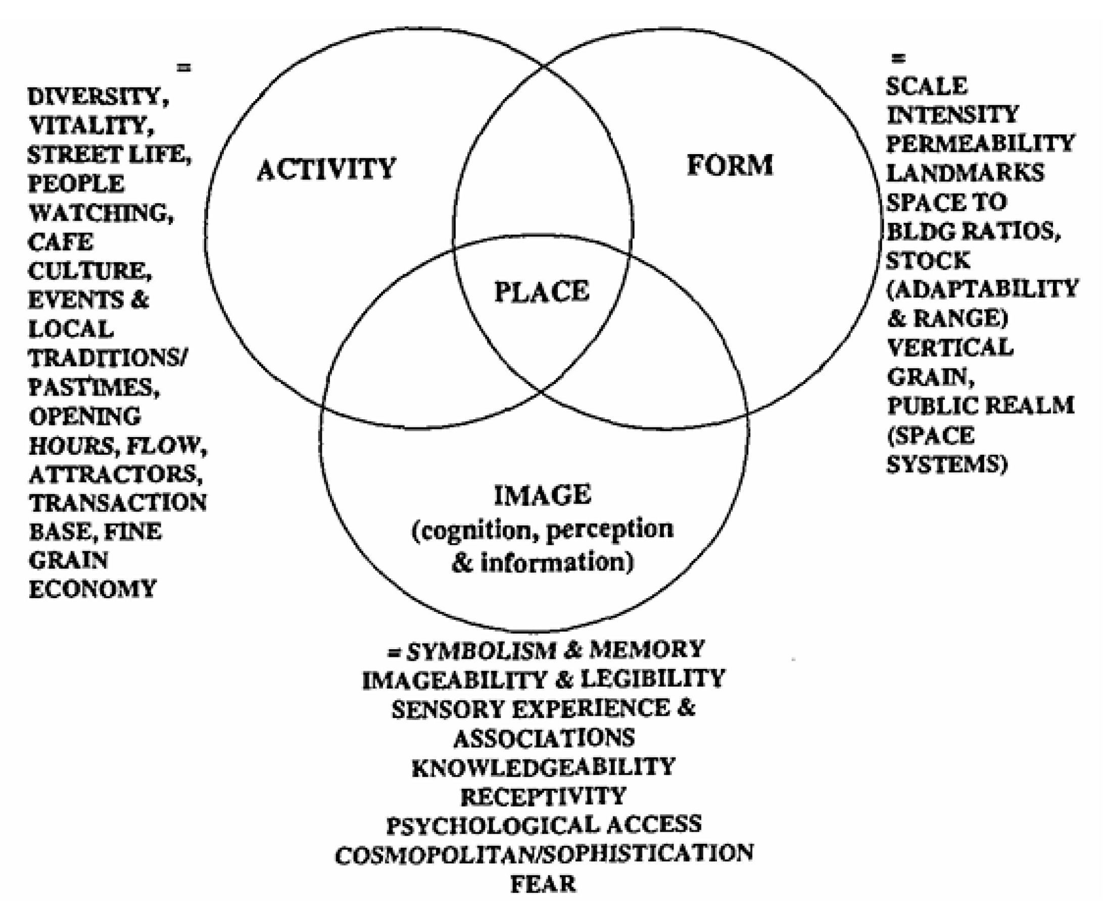
Figure 3.
Gehl’s 12 quality criteria in cities for people (Source: Gehl, 2010).
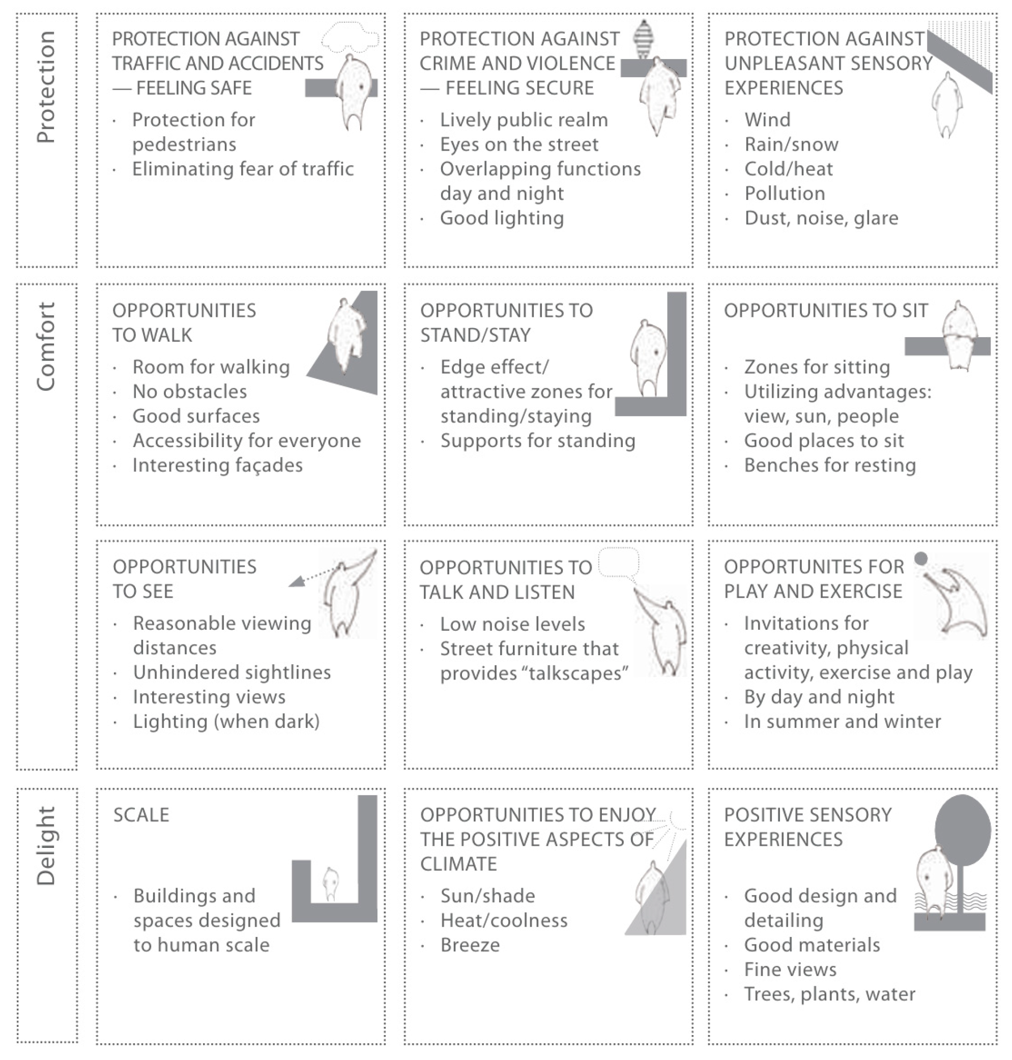
Figure 4.
Urban design process: a place-shaping continuum (Source: Carmona, 2014).
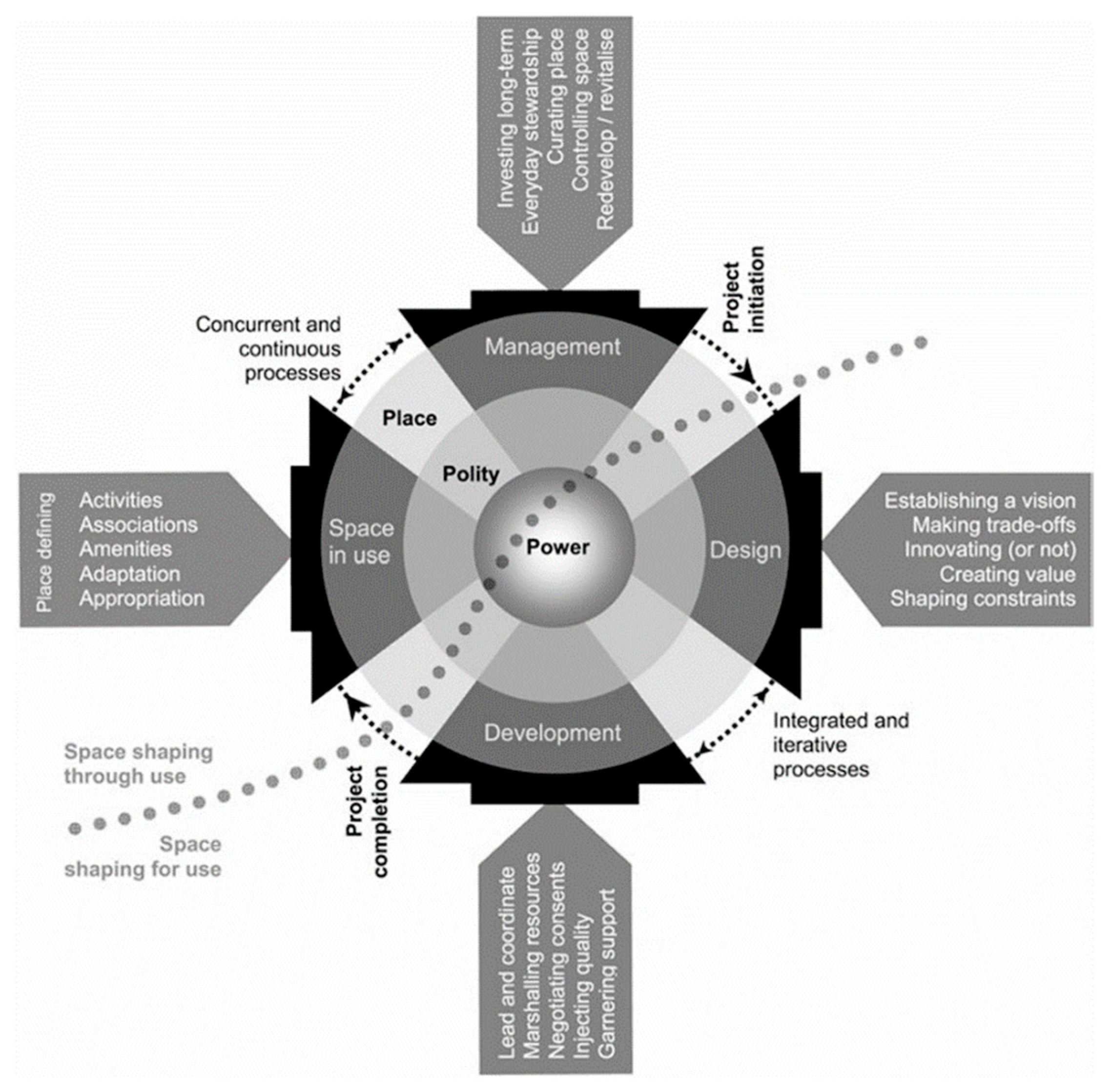
Figure 5.
Assessment framework of urban waterfront open space quality (Source: drawing by author).
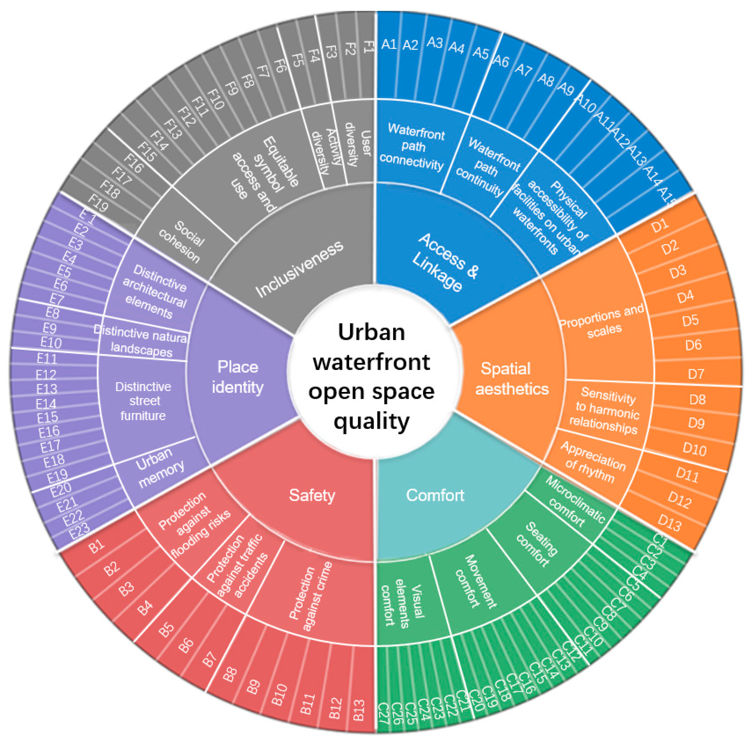
Figure 6.
Location of the study area (Source: drawing by author).
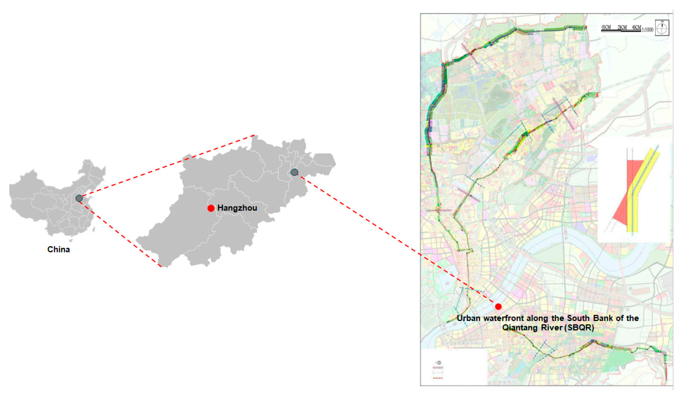
Figure 7.
Location of selected key nodes along the SBQR (Source: drawing by author).
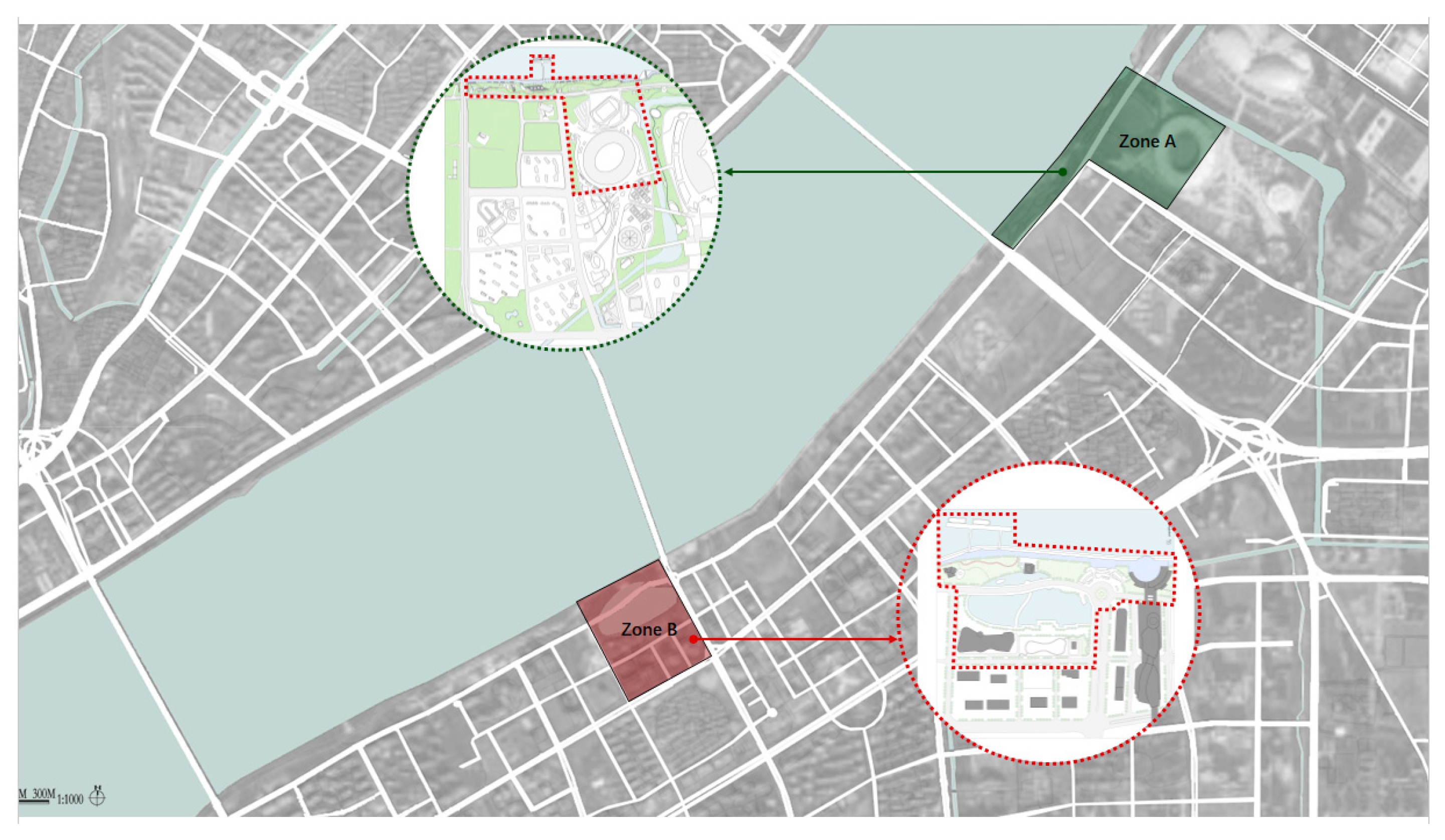
Figure 10.
Classical representation of importance–performance plot (Source: Sever, 2015).
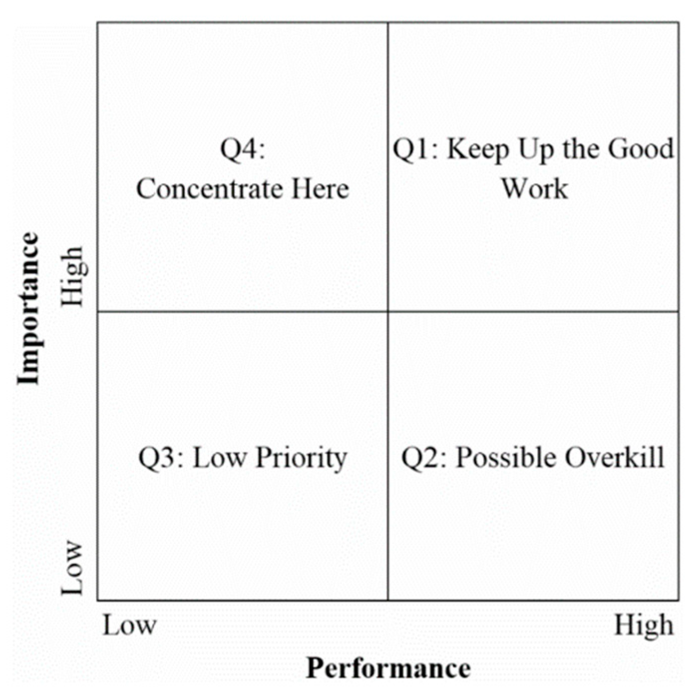
Figure 11.
Motivations for using urban waterfront open spaces at SBQR.
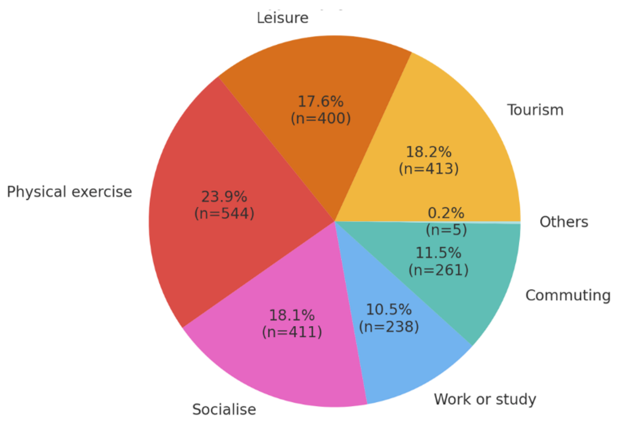
Figure 12.
The relationships between activity patterns and motivations at SBQR.
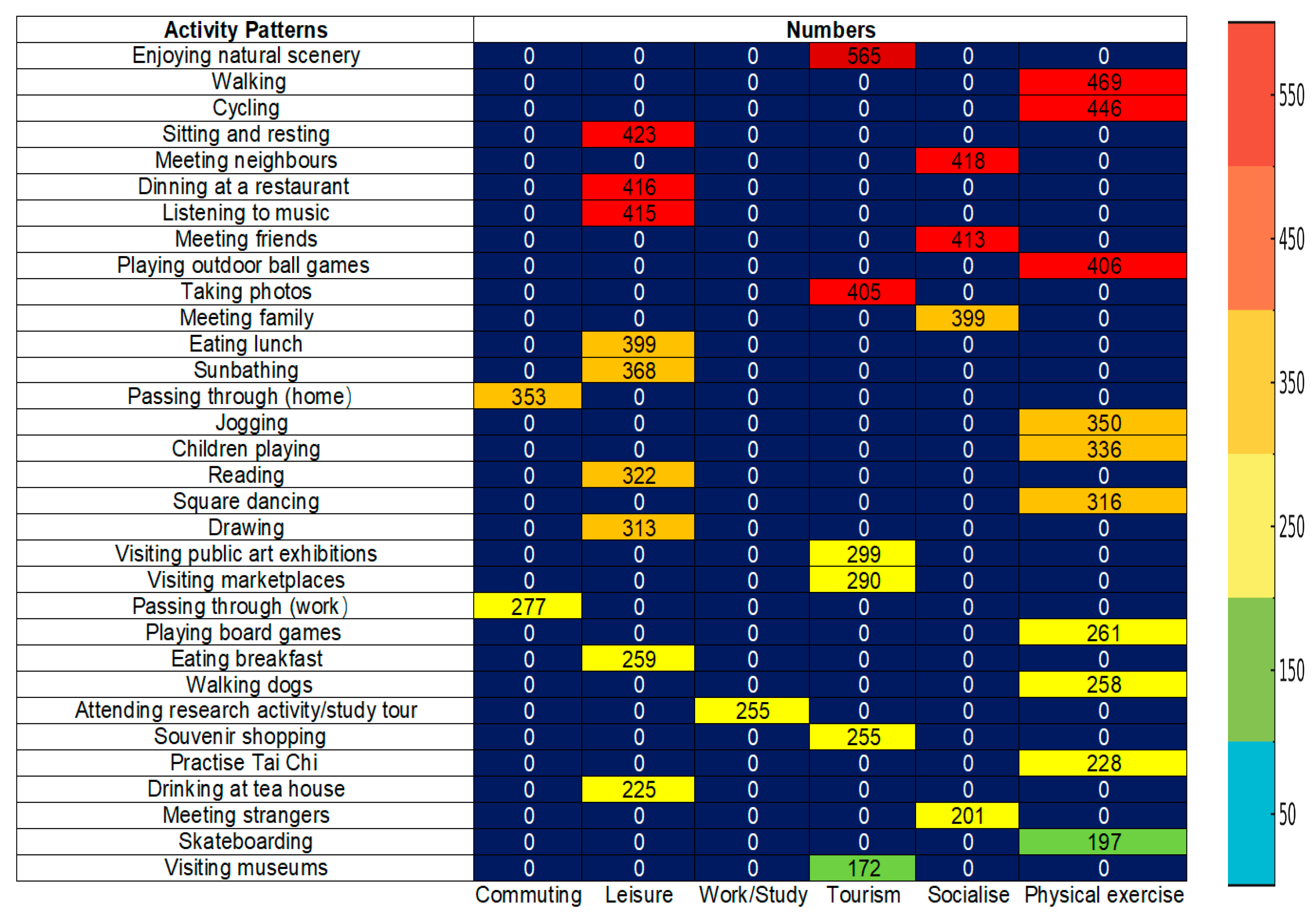
Figure 13.
Importance ratings of urban waterfront open space quality dimensions at SBQR.
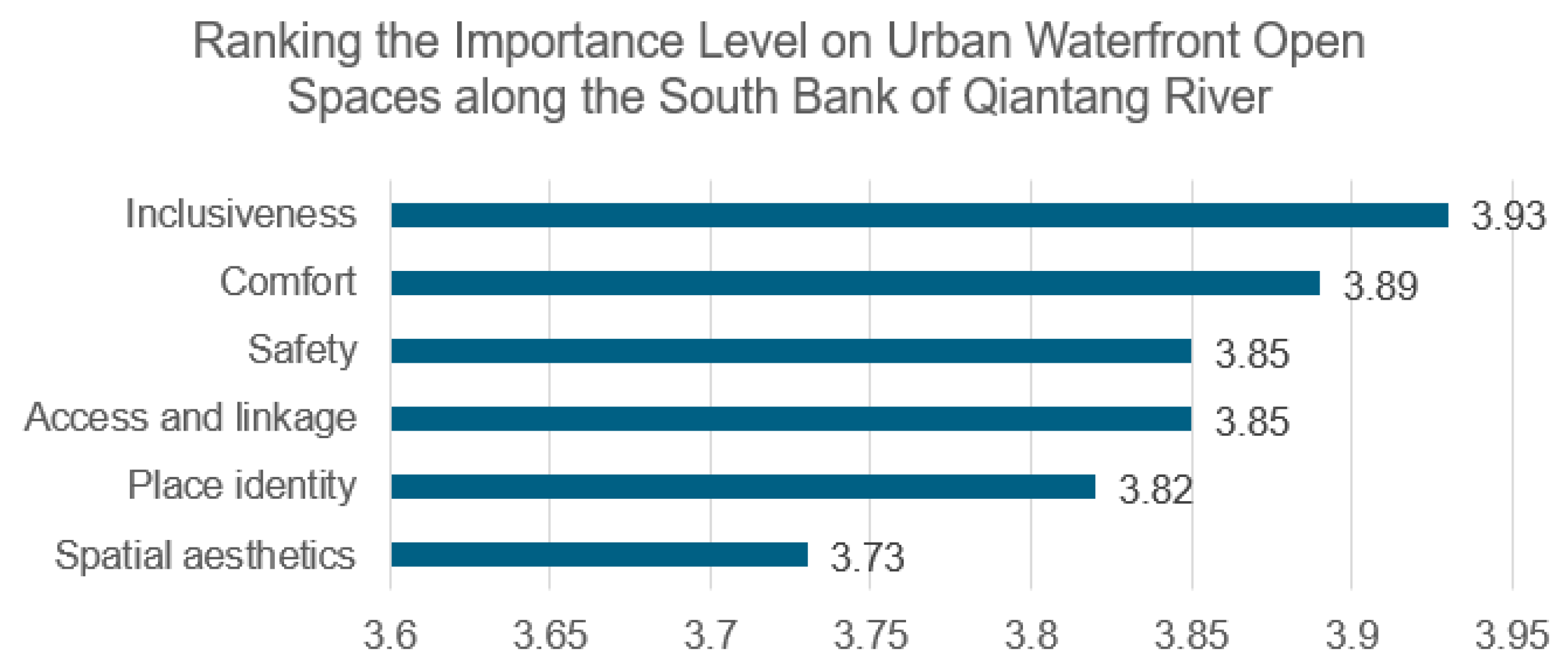
Figure 14.
IPA scatter plot of access and linkage variables at SBQR.
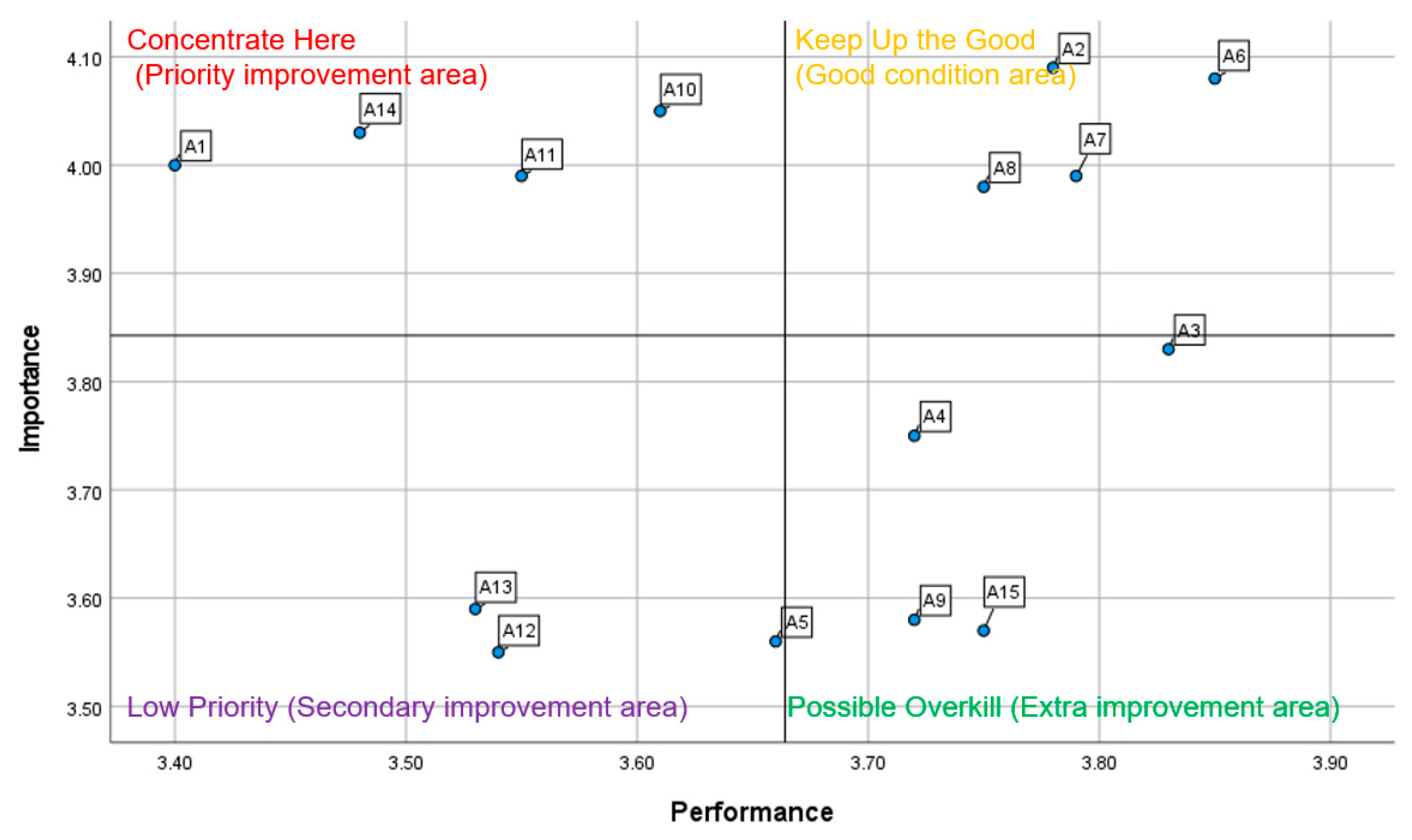
Figure 15.
IPA scatter plot of safety variables at SBQR.
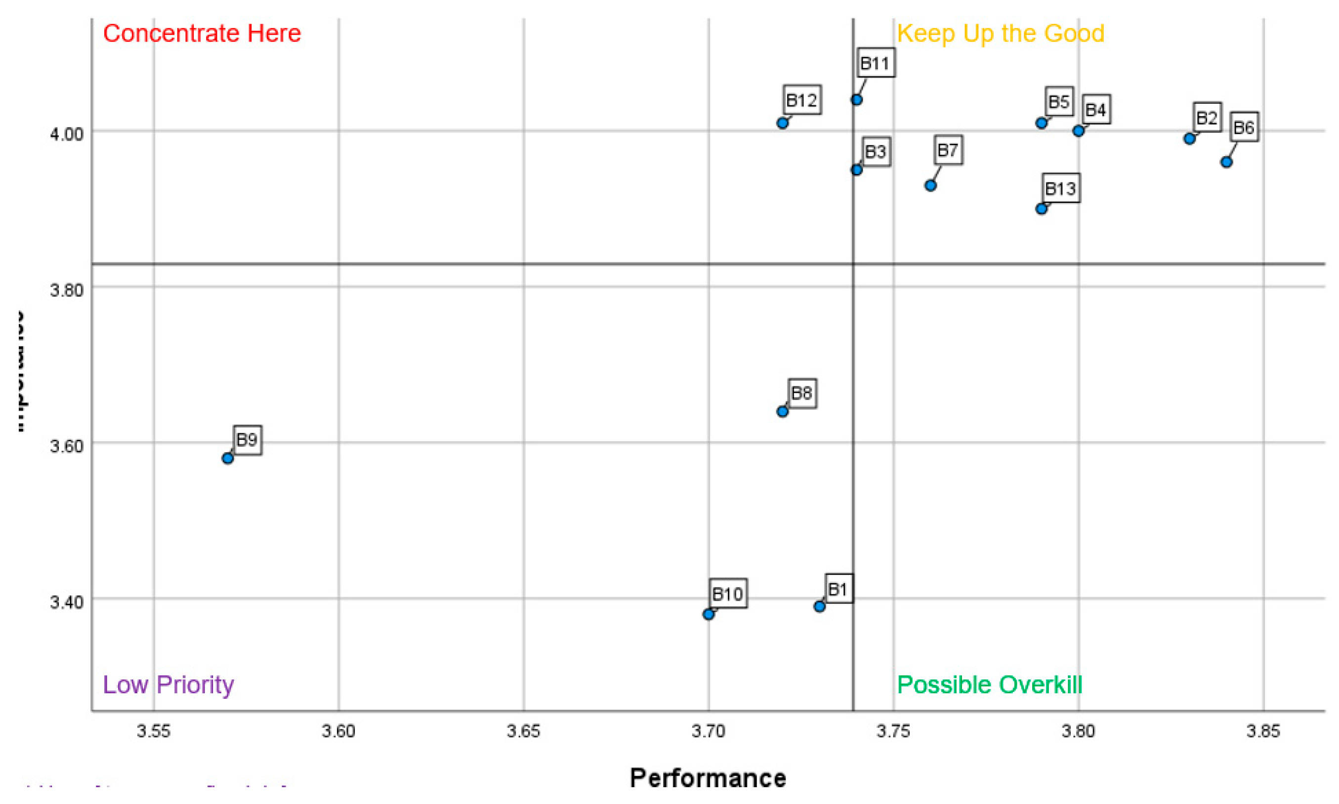
Figure 16.
IPA scatter plot of comfort variables at SBQR.
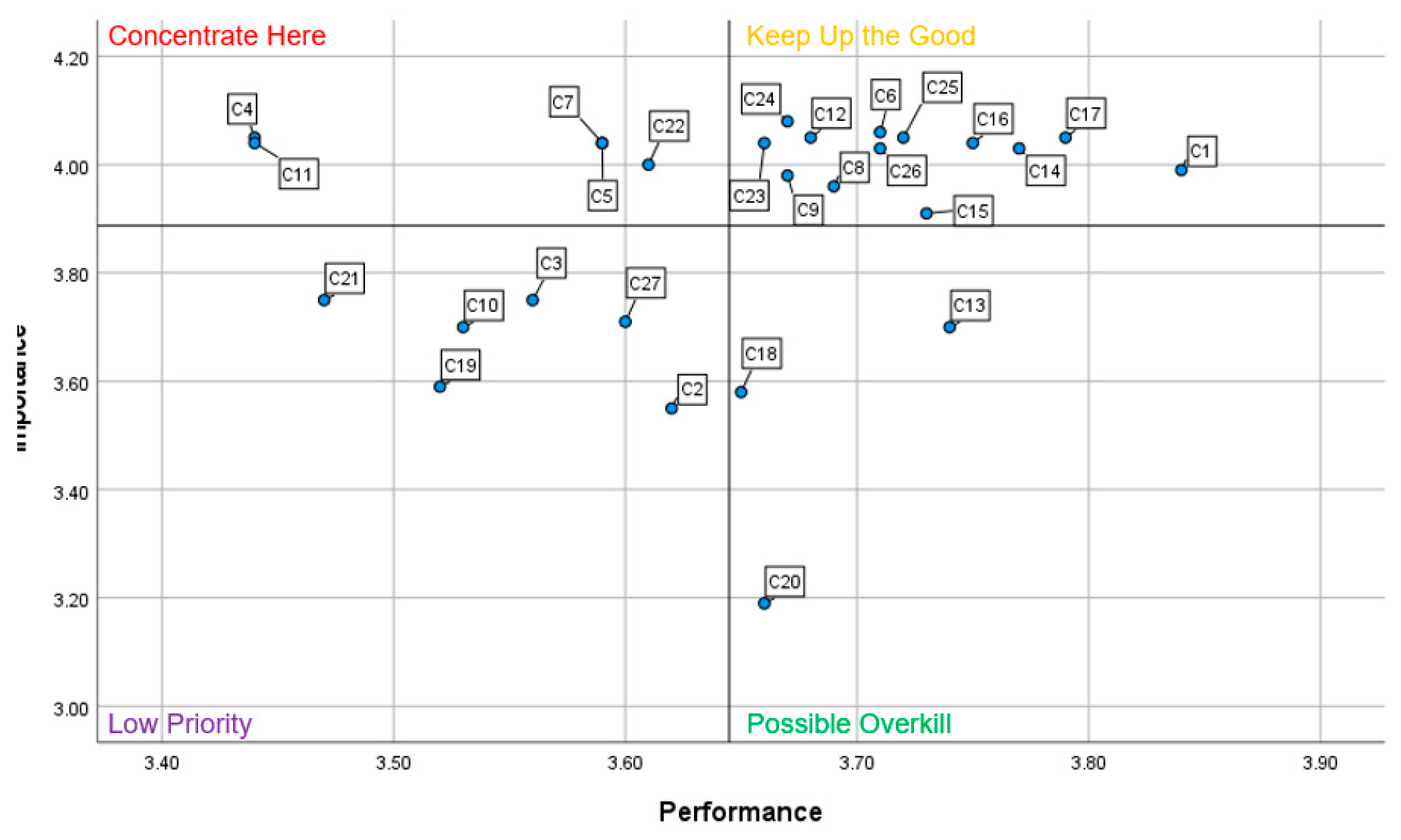
Figure 17.
IPA scatter plot of spatial aesthetics variables at SBQR.
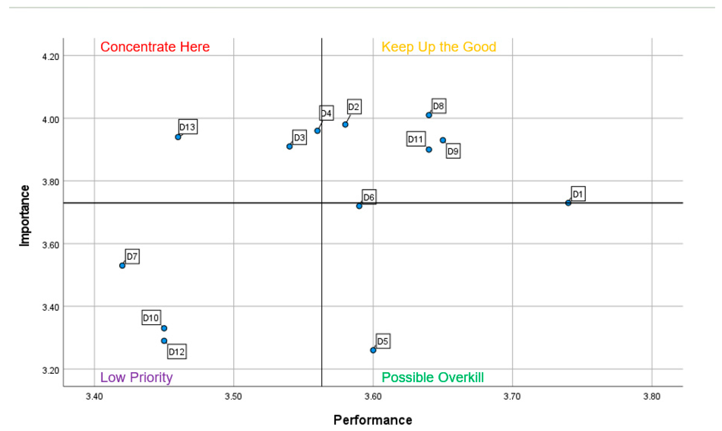
Figure 18.
IPA scatter plot of place identity variables at SBQR.
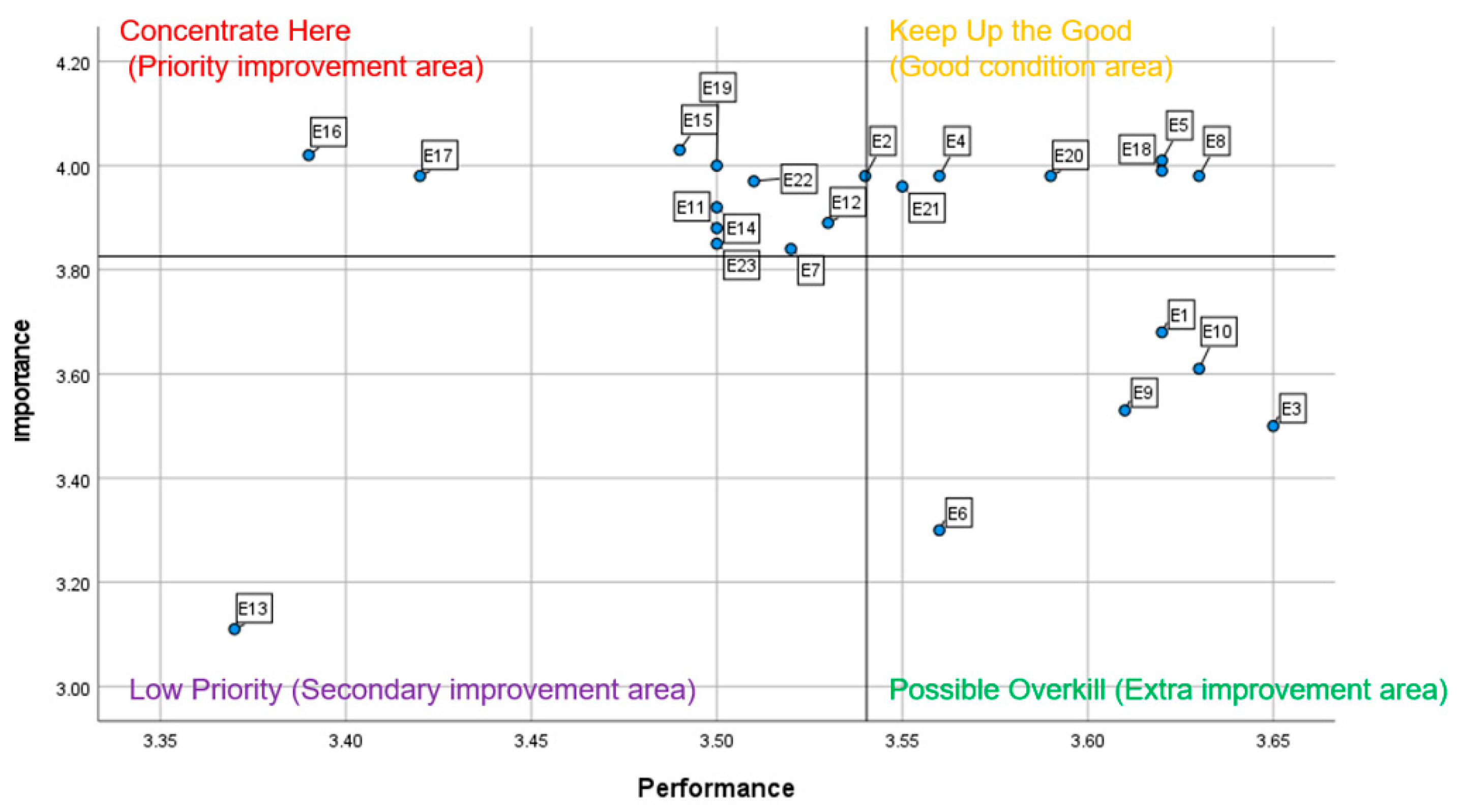
Figure 19.
IPA scatter plot of inclusiveness variables at SBQR.
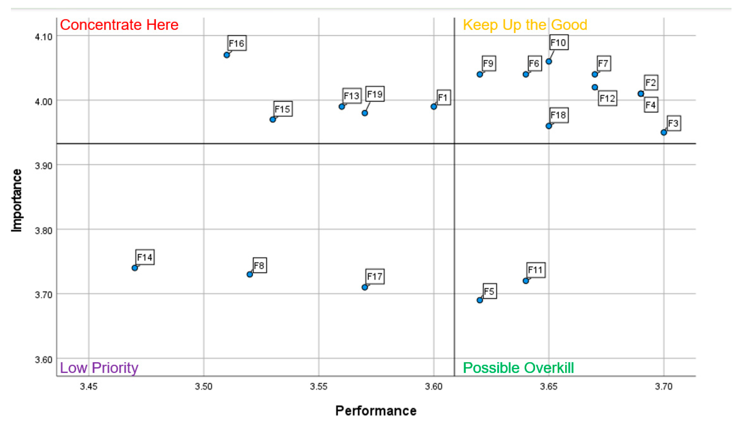
Figure 20.
Slow-mobility circulation system in Zone B (Source: drawing by author).
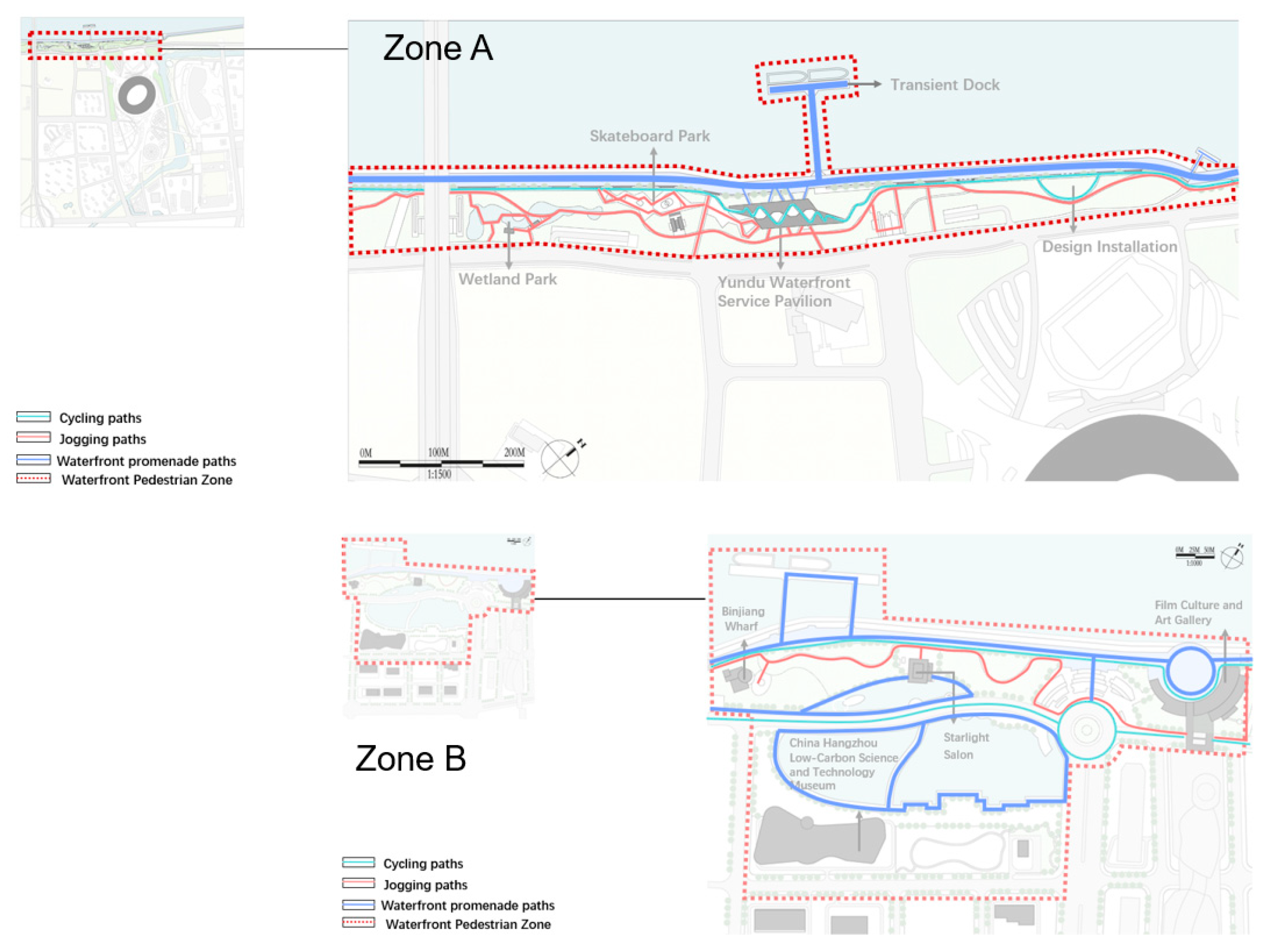
Figure 21.
Mapping of activities in Zone A and Zone B: (a) spatial analysis of user activities observed in Zone A; (b) spatial analysis of user activities observed in Zone B.
Figure 21.
Mapping of activities in Zone A and Zone B: (a) spatial analysis of user activities observed in Zone A; (b) spatial analysis of user activities observed in Zone B.
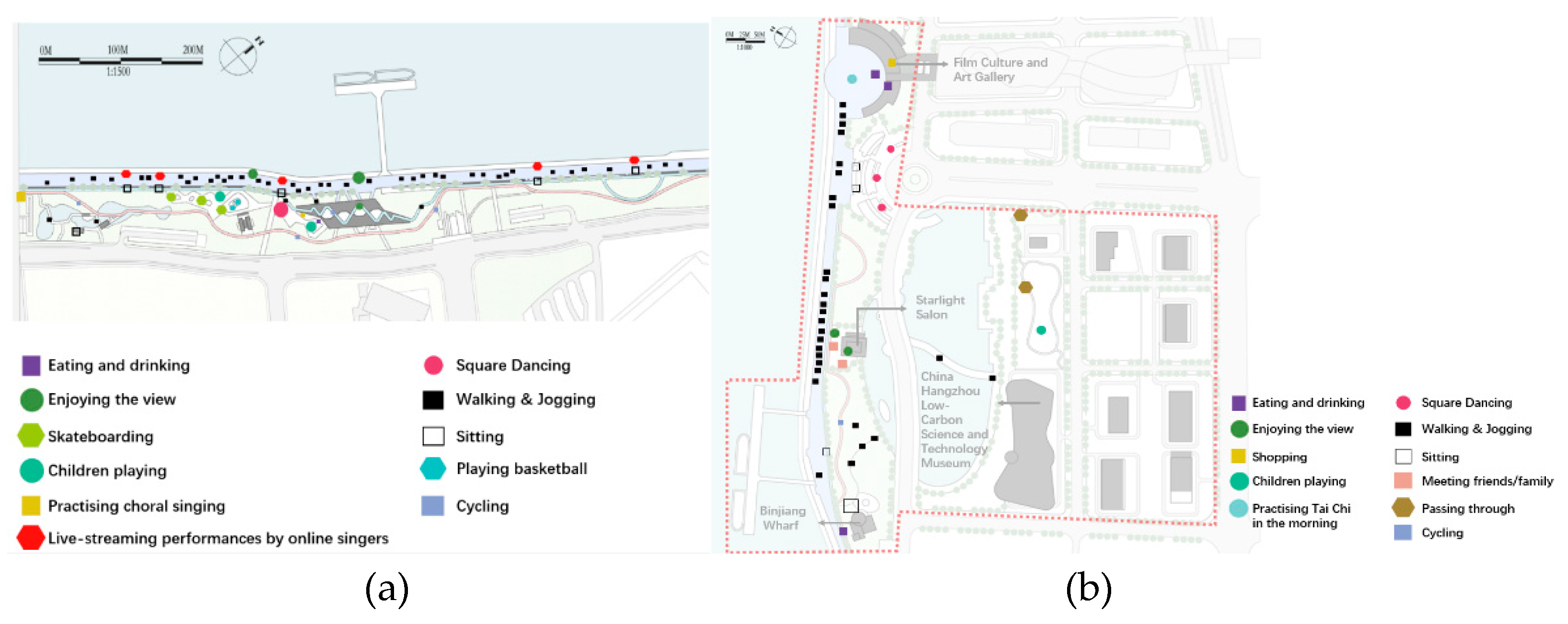
Figure 22.
Physical fencing installed at access nodes and walking promenades along the SBQR.
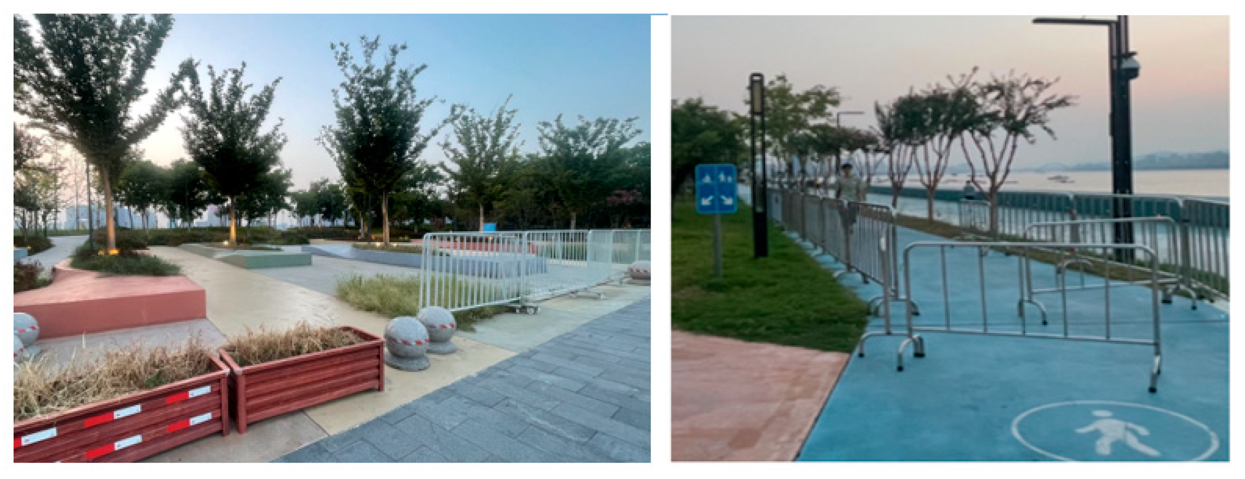
Figure 23.
Users gathering on the steps and within the bridge undercroft during evening social activities along the SBQR waterfront.
Figure 23.
Users gathering on the steps and within the bridge undercroft during evening social activities along the SBQR waterfront.
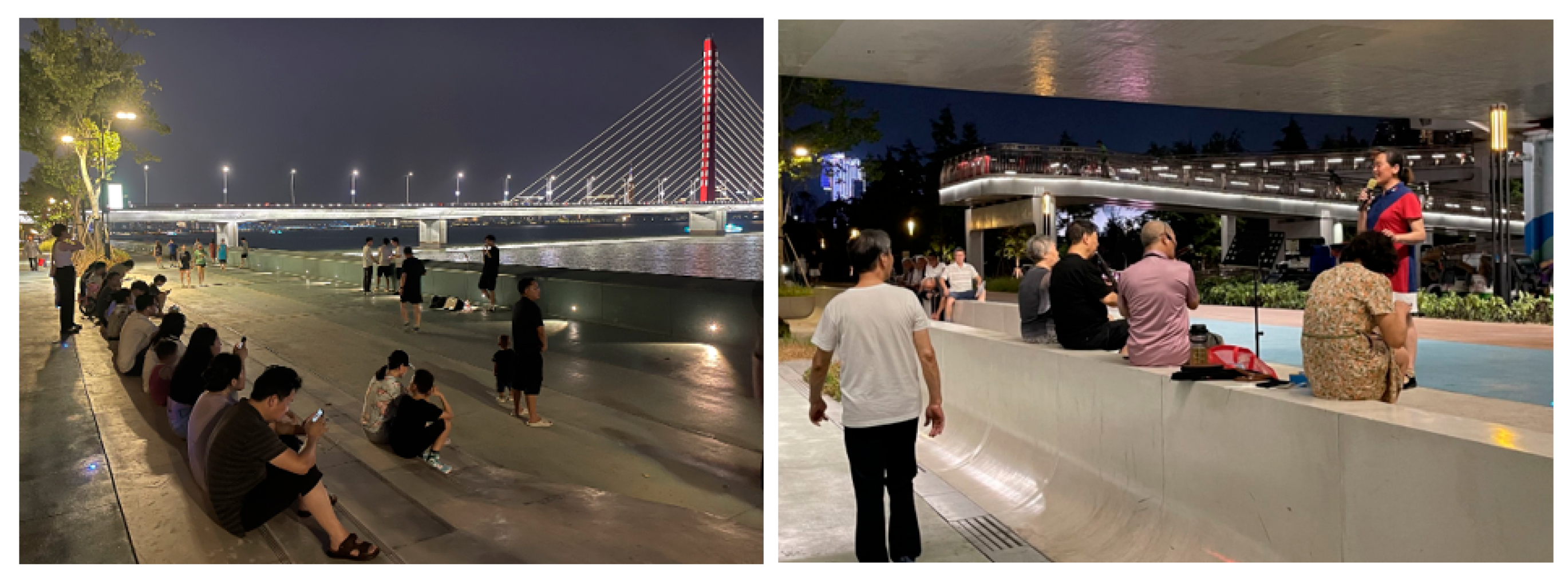
Table 1.
Four stages of place-shaping continuum (Adapted from Carmona, 2014).
| Key processes | Key characteristics |
|---|---|
| Design process |
Establishing a vision that reflects the ultimate purpose of public space design processes |
| Development process | Balancing public and private interests |
| Space in use process | Highlighting use gives meaning to space and decisively shapes the experience of it |
| Management process | Ensuring long-term investment in the public sector and soft controls a to manage undesirable behaviours and to design out certain activities. |
Table 2.
Assessment framework for access and linkage: factors, sub-factors and sub-sub-factors.
| Factors | Sub-factors | Sub-sub-factors |
|---|---|---|
| Access and linkage | Connectivity of waterfront path systems |
A1 The connection between pedestrian bridges and key nodes along urban waterfront open spaces [28,29] A2 The connection between the waterfront promenade route and key nodes along urban waterfront open spaces [30] A3 The connection between the cycling route and key nodes along urban waterfront open spaces [31] A4 The connection between the vehicular route and key nodes along urban waterfront open spaces [29] A5 The connection between the waterborne transportation route and key nodes along urban waterfront open spaces [30] |
| Continuity of waterfront path systems |
A6 The continuity of waterfront promenade routes [2,28] A7 The continuity of cycling routes [32] A8 The continuity of vehicular routes [33] A9 The continuity of water transport routes [34] |
|
| Physical accessibility of facilities on urban waterfronts | A10 Accessibility of water’s edge [31] A11 Accessibility of basic public service facilities (such as parking areas, toilets, public transit stops, waste bins, etc.) [35] A12 Accessibility of sport amenities (such as children’s playgrounds, outdoor skateboard parks, etc.) [36] A13 Accessibility of healthcare services [29,32] A14 Accessibility of cultural venues [37] A15 Accessibility of commercial amenities [38] |
Table 3.
Assessment framework for safety: factors, sub-factors and sub-sub-factors.
| Factors | Sub-factors | Sub-sub-factors |
|---|---|---|
|
Safety |
Protection against flooding risks | B1 Use of temporary flood defences [40] B2 Raising the plinths for buildings within creation of different elevations [41] B3 Use of traditional shoreline infrastructure [41] B4 The integration of waterfront greenways with flood control systems [42] |
| Protection against traffic accidents | B5 Creation of traffic barrier zones [26] B6 Priority for pedestrians in mixed traffic [39] B7 Control of fast-moving vehicles [27] |
|
| Protection against crime | B8 A well-designed urban waterfront street spatial layout without cul-de-sacs [39] B9 The appropriate number of surveillance cameras [43,44] B10 The appropriate number of public/private guards and police [39] B11 Sufficient artificial lighting quality after dark [39,44] B12 Provision of personalising decorations [39] B13 Good maintenance and cleanliness [43,44] |
Table 4.
Assessment framework for comfort: factors, sub-factors and sub-sub-factors.
| Factors | Sub-factors | Sub-sub-factors |
|---|---|---|
|
Comfort |
Microclimatic comfortable | C1 Good air quality [31] C2 Appropriate water surface humidity [31] C3 Presence of temperature-regulating shade provided by natural vegetation (tree planting, shrubs, etc.) [39,45] C4 Provision of artificial shelter from the wind, rain and some sun [39] |
| Seating comfortable | C5 A variety of formal and informal seating options [20,46] C6 An adequate number of sitting arrangements [20,39,47] C7 Low noise level during seating [20,39] C8 Good seating placement, preferably with good views [20,39,48] C9 Appropriate size of seating areas [20,39] C10 Arrangement of movable/flexible seats [49] C11 Materials for seats with insulating and water-repellent properties [31] |
|
| Movement comfortable | C12 The material of the cycle route [49] C13 The appropriate cycle route width [33,45] C14 The material of the urban waterfront promenade route [31] C15 The surface condition of the cycle route [20,31] C16 The appropriate waterfront promenade route width [33] C17 The surface condition of the waterfront pedestrian route [29,49] C18 The surface condition of the vehicular route [29,49] C19 The appropriate vehicular route width [33] C20 The material of the vehicular route [33] |
|
| Visual comfortable | C21 View of rich fauna [49] C22 View of clear visual axis [31] C23 View of clean water body [50] C24 View of rich flora [32] C25 View of good skyline [30,31] C26 View of clear information board and wayfinding [39] C27 Readability of digital transport schedule screens [50] |
Table 5.
Assessment framework for spatial aesthetics: factors, sub-factors and sub-sub-factors.
| Factors | Sub-factors | Sub-sub-factors |
|---|---|---|
|
Spatial aesthetics |
Proportions and scales | D1 The appropriate scale of leisure areas [29] D2 The appropriate scale of commercial areas (Hermosilla et al., 2012) D3 The appropriate scale of cultural venues [49] D4 The appropriate scale of residential blocks [52] D5 The appropriate scale of office areas [52] D6 The appropriate ratio of waterfront street width to building height [39] D7 Sense of enclosure [27] |
| Sensitivity to harmonic relationships | D8 Harmonic spatial hierarchy and organisation [27] D9 Coordination of building facade styles [27] D10 Articulation of historical and contemporary building styles [39] |
|
| Appreciation of rhythm | D11 The rhythm of facades (ratio of solid to void in facades) above ground floor level [53] D12 The rhythm of colonnades in semi-public realms [27] D13 The rhythm of active frontages at the ground floor level [53] |
Table 6.
Assessment framework for place identity: factors, sub-factors and sub-sub-factors.
| Factors | Sub-factors | Sub-sub-factors |
|---|---|---|
| Place identity | Distinctiveness of architectural elements | E1 Distinctiveness of facades [27] E2 Distinctiveness of decorative elements [20] E3 Distinctiveness of balconies [20] E4 Distinctiveness of roofscapes [27] E5 Distinctiveness of building materials [54] E6 Distinctiveness of local structure of buildings [54] E7 Distinctiveness of outdoor elevated walkways [29] |
| Distinctiveness of nature landscapes | E8 Distinctiveness of local plants [21] E9 Distinctiveness of shoreline forms [12,37] E10 Distinctiveness of water body shapes [12,37] |
|
| Distinctiveness of street furniture | 11 Distinctiveness of transit shelter [21,31,39] E12 Distinctiveness of banners/digital billboards [21,31,39] E13 Distinctiveness of bins [21,39] E14 Distinctiveness of lampposts [21] E15 Distinctiveness of fountains [26,27] E16 Distinctiveness of water-related design installations [26,55] E17 Distinctiveness of monuments [21] E18 Distinctiveness of benches [21,31,39] E19 Distinctiveness of artificial terraces leading towards water [39] |
|
| Urban memory | E20 Place names [56] E21 Lifestyle transformation shaped by embodied personal memory [57] E22 Historic preservation of and adaptively re-using existing built form as an embodiment of collective memory [25,57] E23 Cultural and digital heritage interpretation and presentation [58] |
Table 7.
Assessment framework for inclusiveness: factors, sub-factors and sub-sub-factors.
| Factors | Sub-factors | Sub-sub-factors |
|---|---|---|
| Inclusiveness | Diverse users | F1 Variety in age range [52] F2 Variety in gender [39] F3 Mix of diverse community groups [39,44] |
| Diverse activities | F4 Range of behaviours (if granted a public licence) [60] F5 Land-use diversity [15] |
|
| Equitable free use | F6 Equitable free use water feature for all social group [48,55] F7 Equitable free use sports ground along waterfronts [29] F8 Equitable free use Internet service (Wi-Fi) for all social groups [55] F9 Equitable free use children’s play areas on the urban waterside for all social groups [29] F10 Equitable free use accessible ramps on the urban waterside [21,30] F11 Equitable Free use of accessible lifts on the urban waterside [21,30] F12 Equitable access to community-led events/activities [21,26] F13 Equitable free use of movable benches for all social groups [21,26,30] F14 24/7 operational availability of waterfront open spaces [21,44] F15 Equitable free use flexible spaces for all social groups [29] |
|
| Social cohesion | F16 The length of social interaction [21,61] F17 Rational and transparent distribution of public funds [1] F18 An effective community engagement in transparent decision-making processes [1,61] F19 Cooperation of public and private partnership [1,62] |
Table 8.
Demographic information at SBQR based on questionnaire survey.
| Demographic variables at SBQR | Number | Percentage % (n=770) |
|---|---|---|
| Gender | ||
| Male | 440 | 57.1 |
| Female | 316 | 41.0 |
| Others | 2 | 0.3 |
| Prefer not to say | 12 | 1.6 |
|
Age groups |
||
| 18-24 | 103 | 13.4 |
| 25-39 | 290 | 37.7 |
| 40-59 | 220 | 28.6 |
| 60+ | 126 | 16.3 |
| Prefer not to say | 31 | 4.0 |
|
Classification of Participants |
||
| Residents surrounding SBQR | 325 | 42.3 |
| Visitors of SBQR | 336 | 43.6 |
| Designers who evolved design process at SBQR | 41 | 5.3 |
| Staff/managers responsible for management in SBQR | 48 | 6.2 |
| Others | 20 | 2.6 |
Disclaimer/Publisher’s Note: The statements, opinions and data contained in all publications are solely those of the individual author(s) and contributor(s) and not of MDPI and/or the editor(s). MDPI and/or the editor(s) disclaim responsibility for any injury to people or property resulting from any ideas, methods, instructions or products referred to in the content. |
© 2025 by the authors. Licensee MDPI, Basel, Switzerland. This article is an open access article distributed under the terms and conditions of the Creative Commons Attribution (CC BY) license (http://creativecommons.org/licenses/by/4.0/).
Copyright: This open access article is published under a Creative Commons CC BY 4.0 license, which permit the free download, distribution, and reuse, provided that the author and preprint are cited in any reuse.


