
Submitted:
11 November 2025
Posted:
12 November 2025
You are already at the latest version
Abstract
Complex landslides have characteristics and parameters that are difficult to analyze. The landslide on June 16, 2024, in the rural community of Quilloturo (Ecuador) caused severe damage (14 deaths, 24 injuries, and hundreds of affected families) related to the area's geological, social, and anthropogenic conditions. Its location in the eastern foothills of Ecuador's Cordillera Real (Royal Mountain Range) exacerbated the effects of a landslide involving various processes (mud and debris flows, landslides, and rock falls). This event was preceded by intense rainfall lasting more than 10 hours, which accumulated and caused natural damming of the streams prior to the event. The lithology of the investi-gated area includes deformed metamorphic and intrusive rocks overlain by superficial clayey colluvial deposits. The relationship between the geological structures found, such as fractures, joints, schistosity, and shear, favored the formation of blocks within the flow, making mass movement more complex. Geomorphologically, the area features a relief with steep slopes, where ancient landslides or material movements, composed of these colluvial deposits, have already occurred. At the foot of these steep slopes, on plains less than 300 meters wide and bordered by the Pastaza River, there are human settlements with less than 60 years of emplacement and a complex history of territorial occupation, characterized by a lack of planning and organization. The memory of the inhabitants identified mass movements that occurred since the mid-20th century, with the highest frequency of occurrence in the last decade of the present century (2018, 2022, and 2024). Furthermore, it was possible to identify several factors within the knowledge of the in-habitants that can be considered premonitory of a mass movement, specifically a flood, and that must be incorporated as critical elements in the decision-making, both individual and collective, for the evacuation of the area.
Keywords:
mass movement
; complex landslides
; social knowledge
; social memory
; Ecuador
; Andean Cordillera
1. Introduction
The impact of mass movements in the Andean mountain ranges and South America is determined not only by geological conditions and physical factors, but also by the interaction with social factors that shape disasters [1,2,3]. This comprehensive approach directly influences the vulnerability, response, and adaptation capacity of exposed communities [4]. The magnitude of the disaster, therefore, is explained by pre-existing conditions of social vulnerability, rather than solely by the intensity of the physical phenomenon [1]. This is influenced by population density, land use, a lack of knowledge about the territory, and institutional capacity for risk management [5,6]. In this context, a comprehensive landslide analysis requires a deep understanding of lithology, geological structures, geomechanical and hydrogeological conditions, and precipitation patterns. These parameters, along with socioeconomic conditions (including occupation zones and the level of social preparedness for hazards), shape the risk to which a community is exposed [2,5,7].
Mass movements pose a constant threat in countries with rugged geomorphology and topography, especially when the geological conditions of the terrain can exacerbate these processes. In the case of Ecuador, the interaction of natural and social factors complicates the assessment of these events and risk management [1,9]. Mass movements are gravitational displacements of the terrain (soil and/or rock) in areas with steep slopes, which can include landslides, flows, and rockfalls, constituting one of the most frequent natural hazards and one with the most significant social and economic impact in the Andean region [2,9,10,11]. The assessment of ground stability must consider geotechnical, geological, and geomorphological parameters (lithology, slope, geological structures), taking into account changes in infiltration due to precipitation. Additionally, land use and the influence of other triggering factors, such as seismicity, must also be considered [8,12,13].
The trigger for mass movements is frequently linked to rainfall (abnormal or torrential and seasonal), which is often intensified in relation to climate change or periodically occurring phenomena, such as the El Niño and La Niña phenomena in South America [14,15,16]. These physical factors are critical when the social dimension increases the vulnerability of exposed communities. The community's perception of risk is a fundamental point to be considered in the entire process, and their social conditions and preparedness play a role in the adoption of mitigation measures to address these events [5,6,7]. Elements such as lack of planning, population density, socioeconomic level, land use, lack of knowledge of geological activity, and institutional capacity in risk management increase the severity of the associated consequences [2,3].
This research uses the event that occurred in Quilloturo (Ecuador) in June 2024 as a case study, which exemplifies a complex mass movement event that occurred in a low-prepared area. Extraordinary or extreme rainfall in the days and hours leading up to the event not only caused slope instability but, combined with the social and human factors present in the area, resulted in a disaster with casualties and material losses [17]. This phenomenon involved a combination of geodynamic processes, including landslides, debris flows, rockfalls, displacements, and flash flooding. That, suddenly, impacted the natural environment and local populations, ultimately affecting social conditions [17]. This highlights the need to integrate interdisciplinary approaches in risk analysis and management [8].
In Ecuador, studies conducted in the Portoviejo (Manabí province) and Cuenca (Azuay province) areas show that the underestimation of risk, often due to a lack of awareness, contributes to the exposure of population settlements in potentially unstable areas. This is exacerbated by deficiencies in institutional communication and a lack of environmental education, which translates into a lack of understanding of mass movement processes [5,6].
The article aims to analyze the interrelationship between the physical and social conditions that contributed to the magnification of a complex mass movement. It is based on the application of a methodological framework that integrates geological, geotechnical, geomorphological, and social analyses. The goal is to obtain relevant technical evidence that can be incorporated into the formulation of municipal and local risk management policies, articulating the physical dimension of the hazard with social knowledge and vulnerabilities. This will help mitigate or reduce exposure and improve community resilience to future events [2,3,8].
2. Geographical Location and Geological Characteristics
2.1. Geographical Location and Geomorphology
The study area is located between the hamlets of La Merced and Quilloturo and is part of the rural parish of Río Verde (Baños de Agua Santa canton, Tungurahua province) in Ecuador (Figure 1). It is crossed by the Baños–Puyo road (E30), which is part of the state road network and constitutes one of the most important communication routes in the country, as it connects the Coast and the Central Cordillera with the Amazon.
The settlements are located in narrow, flat areas, measuring less than 300 meters in width and elongated in shape. They are bordered to the north by State E30 Road and to the south by ravines formed by intense erosion of the edges of the lava flow formations from the Tungurahua volcano (located further south in the study area). These settlements, known as hamlets, are located from west to east as La Merced, San Jorge, El Placer, and Quilloturo (Figure 1).
Geographically, it is located in the heart of the Cordillera Real of the Andes. Its area of influence is characterized by extremely steep terrain, with slopes exceeding 30°, corresponding to a fluvial valley with steep V-shaped vertical cuts. This valley is drained by the Pastaza River, which crosses the area from west to east, and several high-altitude (high-energy) rivers also drain into it. On the left bank, the Blanco and Verde rivers converge, along with the San Jorge, La Merced, and San Pedro streams, and other unnamed streams, such as those that run through the hillsides near the hamlets of El Placer and Quilloturo. The Chinchin Chico, Chinchin Grande, and San Pedro rivers are tributaries of the Pastaza River on its right bank [17].
The main characteristic of all the tributaries is the turbulent flow of their waters, due to the steep slopes, which gives them high energy, high erosive power, and transport capacity. These aspects enable the transport and/or erosion of supermetric rock blocks. Climate is characterized by heavy rainfall episodes (in intensity and duration) during the winter season from June to August [17].
2.2. Geological Knowledge
The Cordillera Real of the Andes, where the study area is located, is a mountain range composed mainly of metamorphic rocks arranged in north-south trending bands and covered, in some places, by rocks and surface deposits of volcanic materials and a sedimentary origin (Figure 2). Metamorphic rocks include graphite-garnet-muscovite and paragneiss schists (Agoyán Unit), gneissic granite (Tres Lagunas Unit), graphitic schist and gneiss (Cuyuja Unit), and marble and metasediments (Cerro Hermoso Unit). In addition, intrusive igneous rocks, such as granodiorites and deformed diorites of the Azafrán Unit, have been mapped. West of the town of Río Verde, a small calcic-magnetic skarn outcrops as a result of hydrothermal alteration associated with metamorphism, known as the Río Verde skarn [19].
Structurally, the area is traversed by regional faults trending NNE-SSW, including the main ones known as the Baños and Llanganates faults. The former is a right-lateral strike-slip fault, while the latter is a reverse fault with the hanging wall moving ESE [19]. Other important structures include faults that form the tectonic contacts between the Cerro Hermoso, Cuyuja, and Azafrán units, classified as reverse faults [19](Figure 2).
All the metamorphic rocks that outcrop on the left bank of the Pastaza River, from La Merced to the confluence of the Patate and Chambo Rivers, as well as those that outcrop on the right bank, from the Agoyán Dam to La Merced, exhibit very continuous, finely spaced, and in some parts folded schistosity or foliation planes related to metamorphic processes (Figure 3a). This geological structure has an NNE-SSW orientation with planes that are strongly inclined to subhorizontal (Figure 3b).
From the La Merced sector (San Jorge ravine) to Azafrán (3 km east of Río Verde, and already outside the study area), the rocks are traversed by mostly vertical, N-S trending planes (Figure 3a). These planes, called cleavage planes or shear joints, formed during deformation processes [20], are more discrete or not very evident, are spaced at millimeter intervals, and exhibit gentle undulations (Figure 3b). According to Litherland et al. [19], evidence of deformation decreases drastically to the east, where the aforementioned geological feature disappears. This geological structure varies from N-S/vertical to NE-SW, dipping to the SE and NW.
The rocks and surface deposits of volcanic origin are related to the recent activity of the Tungurahua volcano and are large lava flows emplaced along the Pastaza River channel. Sedimentary deposits are related to the erosion and transport of rock fragments and debris of various sizes by water and/or gravity, deposited on the slopes or beds and margins of the rivers and streams that cross the region. Several surface geological processes of an erosive nature also affect the rock massif of the Cordillera Real of the Andes (Figure 4a). Specifically, the La Merced-Quilloturo area (part of the Patate-Baños-Mera region) is characterized by the continuous presence of these erosive processes, which are also associated with mass movements of varying magnitude and type.
Most of the mass movements that have occurred in the area in recent years are small. However, due to the presence of mountainous areas with steep slopes, these processes possess high energy, which is why they form very rapid flows that may be channeled. This characteristic causes these processes to generate strong impacts, even leading to the destruction of mitigation works (Figure 4b).
3. Past and Background of Mass Movements in the Area
The study area is prone to various types of mass movements, including avalanches, debris flows, rockfalls, and combined or complex landslides, which have been identified for some time.
Rock and mud avalanches are the most frequent events that occur along the margins of ravines and in the slope cuts of communication routes, varying in magnitude, composition, and speed. These are material falls that can occur in dry or wet conditions, accompanied by blocks, debris, and soil that are activated in areas of steep slope, depositing in the lowest and most stable areas.
Debris flows, which are typically associated with the winter season (rainy period), occur along natural channels such as ravines and rivers. They can be slow or rapid depending on the saturation of the material and involve the movement of small particles up to medium-sized blocks.
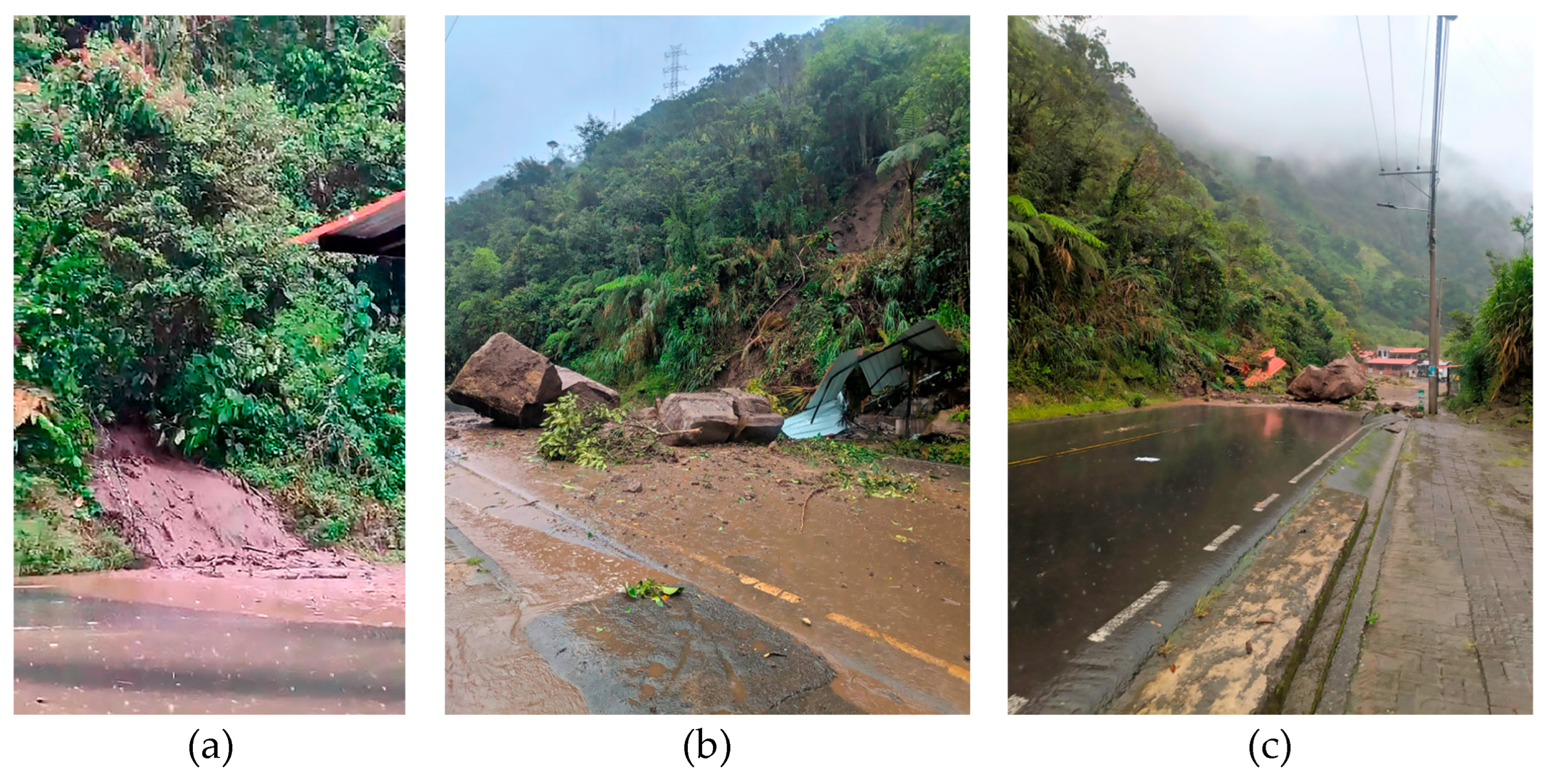
Rockfalls are typically restricted to areas with steep slopes and the presence of a highly fractured and exposed rock mass. The size of the blocks (up to 18 m) varies depending on the fracturing state of the rock mass, the slope of the embankment, and the distance and mode of displacement (Figure 5a). In the case of free fall, the blocks may collide with each other (fragmentation) or come into contact with the slope surface (sliding and flow systems).
Complex or combined mass movements consist of various types of processes described above, which may originate with an initial typology and evolve or change throughout their development, as was the case with the event that occurred in the Quilloturo sector (in 2024).
The collection of information on historical landslides has relied heavily on the verbal testimonies of the EcoMinga Foundation's park ranger team (NGO, Network for the Protection of Threatened Forests, https://ecominga.org/. Accessed on 25 August 2025, EcoMinga hereafter) as one of its most reliable sources. Furthermore, working with the community through focus groups, which included representatives and residents of the affected areas, allowed for the identification of landslides that have impacted the villages since the mid-20th century, as well as establishing the characteristics and parameters used by residents to describe, identify, and characterize them.
According to community memory, approximately 70 or 80 years ago, a flow-type event, locally known as an alluvial flood, occurred in the same area as the Quilloturo event, but on a much larger scale, covering the entire surface of what is now the Quilloturo community and even overflowing the Pastaza River. There are no written records or direct sources to verify whether there were fatalities or destroyed houses. This is an example of community knowledge transmitted orally from one generation to the next, reflecting the experiences and understanding that result from living within a specific territory [21]. Despite the lack of documentary evidence, a possible connection is suggested between this event and the one that destroyed Ecuador's first hydroelectric plant, located in Río Verde, in 1945 [22].
Regarding the occurrence of recent events, documentary evidence is available, including technical reports from the National Risk Management Secretariat (SNGR) and digital press records. For example, the Situation Report – Rainy Season Ecuador No. 25 [23] from the National Risk Management Secretariat (SNGR, the Spanish abbreviation) indicates that on April 28, 2018, several landslides occurred, affecting the Baños-Puyo road (E30). Specifically, the landslide in the El Placer sector swept away a bus, resulting in two deaths and 28 injuries [24] (Figure 5b). According to information from residents, the landslide was caused by a collapse resulting from water damming, which triggered a debris flow from the hillside onto the road.
Another similar and significant event occurred in 2022 following a period of heavy rains that also dammed up in a ravine, generating a mudflow (affecting a house with three people and a heavy vehicle) [26] (Figure 6a,b). The community identifies this event as the Los Chivos mudslide, making it a local reference point for debris flows, their warning signs, and the damage they can cause.
The most recent one, the Quilloturo mudslide, occurred on June 16, 2024, and is one of the most impactful events recorded to date in this area (Figure 5a), serving as the starting point of this investigation and resulting in a total of 14 victims being inventoried.
4. Methodology and Field Data Acquisition
4.1. Geological Field Data Acquisition Methodology
The geological characterization was based on a process of analysis and evaluation to validate the available geological information and publications, including those generated by Litherland et al. [19]. This documentation was complemented by new cartographic and descriptive data on the rocks and, above all, the geological structures of the study area. For the documentation of historical mass movements, data were obtained from different sources and fieldwork for delineation, in addition to verbal testimonies obtained by the support team in the social component (EcoMinga).
The recognition and identification of critical zones that were included in the inventory and diagnosis of mass movements comprised structural mapping associated with the lithologies, with sampling (of soils and rocks) for subsequent laboratory testing. Petrographic analyses (macroscopic and microscopic) were applied to the rocks, and granulometric and triaxial tests were performed on the soils. The results obtained enabled us to complement the existing information on geology, structure, and mass movements gathered in previous phases.
4.2. Social Knowledge and Methodology in the Analysis of Mass Movements
The community information gathering focused on collecting and analyzing collective memory and local perceptions of mass movements that occurred on the slopes between La Merced and Quilloturo.
The methodological approach combined qualitative and participatory techniques, aiming to integrate the community’s empirical knowledge with the technical and geospatial analyses performed. The adoption of participatory methodologies is justified by the need to incorporate the population’s perception of risk and perspective for a comprehensive vulnerability analysis [4].
For the design of the interview and focus group guides (Figure 7a), four thematic axes were defined to guide the data collection:
- a.
- Temporal and spatial characterization of the hamlets. Composed of an analysis of the history and development of the communities, economic activities, migration processes, and population growth, and finally, the identification of milestones that modified the social and territorial dynamics.
- b.
- Characterization of mass movements. This involved analyzing the location and names of drainage systems (ravines) according to local memory, describing land uses on hillsides (agriculture, grazing), and the relationship between the intensity and duration of rainfall and the occurrence of events.
- c.
- Analysis of precipitation and the event of June 16, 2024. This included comparing recorded rainfall with previous years, identifying and describing the mass movements documented by the community, and recognizing natural “premonitory” factors observed by the inhabitants.
- d.
- Reconstruction of the sequence of events of June 2024. Based on the accounts of the chronology of the events, the reported impacts, and the assessment of the perceived magnitude.
At the same time, semi-structured interviews were conducted with residents of La Merced and El Placer (Figure 7b), focusing on:
- Identifying the characteristics of the hillsides, ravines, and springs through the creation of interactive maps.
- Describing mass movement events, their relationship to rainfall, and their impacts at the community level.
- Documenting historical aspects of the communities, their livelihoods, and social and economic transformations.
Thus, a focus group was established with 25 residents of Quilloturo, where participatory methodologies were employed to recover collective memory. The activities included:
- Group creation and development of interactive maps (Figure 8), where geographical features, ravines, and past events were located.
- b. Plenary session for comparison and validation, which allowed for the exchange of information between groups and the prioritization of events and rainfall using a subjective scale of 1 to 5, where 1 represents a minor event and five a major event, such as the one that occurred on June 16, 2024.
- c. Collective construction of a timeline to identify relevant milestones from the formation of the hamlet to the 2024 event.
All participants were adult residents of the hamlets of El Placer, Quilloturo, and La Merced, who voluntarily consented to participate and provide information for research and scientific dissemination purposes.
The activities were carried out in two field campaigns, as detailed below:
- First campaign: unstructured interviews with two eyewitnesses (Darwin Recalde and Carlos Freire) of the events of June 15 and 16, 2024, complemented by visits to the impact zone in Quilloturo. This activity enabled the reconstruction of the temporal and spatial sequence of rainfall and landslides, as well as their primary impacts.
- Second campaign: semi-structured interviews and the creation of community maps with three residents of El Placer and three of La Merced, focusing on local history, the affected areas, risk perception, and community strategies in response to the events.
The information obtained through interviews, maps, and the focus group was compared with the results of technical analyses, field observations, and document review. This process enabled the linking of local knowledge with geological, rainfall, and geospatial evidence, providing a comprehensive understanding of the environmental and social dynamics associated with the mass movements that occurred in June 2024.
5. Results
5.1. Local Geology and Implications for Mass Movements
In general, it has been observed that in areas with steeper slopes (vertical to sub-vertical), most of the rock outcrops are fresh and resistant to the unconfined compression test (Smith's hammer). In contrast, in areas with gentler slopes (inclined to sub-horizontal), the rocks are weathered to highly altered, with residual soil development that can reach a thickness of up to 3 m.
The metamorphic basement rocks outcrop on slopes greater than 40°, occupying the study area from the entrance to the El Puyal sector (right bank of the La Merced ravine) to approximately 200 meters west of the San Jorge River. They also outcrop on the slopes of the La Merced-Puyal, La Merced-El Corazón, and Río Verde-Llanganates roads (the latter outside the study area), as well as on some riverbanks and streambeds, such as those of La Merced and San Jorge. The sequence consists of quartz-feldspathic schist, quartz-biotite schist with calcite, chlorite schist, and muscovite-biotite schist. Litherland et al. [19] also report the presence of gneisses.
Intrusive igneous rocks outcrop in the eastern part of the study area, along the Baños-Puyo road (E30), from the San Jorge River to the tunnel between Quilloturo and Río Verde. Outcrops are also observed in the channels and margins of the Los Chivos and Quilloturo ravines. The outcropping rocks are fresh and composed of minerals with no (or very weak) orientation, containing quartz, slightly altered plagioclase, and biotite. In thin sections, the quartz shows deformation. In the outcrops on the road slope between Quilloturo and the San Jorge ravine, as well as in the drainage channels between Quilloturo and San Jorge, the mineral components are moderately to strongly oriented or aligned, forming bands of sheared rocks parallel to the cleavage and geological faults.
One observable characteristic is that rock alteration is more intense on the northeastern edge of the study area, specifically in the headwaters of the Quilloturo and Los Chivos ravines, which form part of the mountains separating the Pastaza and Río Verde river basins. In some outcrops, the rock mass exhibits strong evidence of stratified or layered sedimentary structures. It is therefore considered to be of volcano-sedimentary or volcaniclastic origin, with clear indications of recrystallization (Figure 9a).
The existence of stratified rocks (in thick layers) of volcaniclastic origin is corroborated by the composition and structures of the tabular blocks (≤ 3 m in diameter) of fine-grained rocks present in the deposit formed during the mass movement that affected the Quilloturo area in 2024 (Figure 5a).
The current surface deposits in the study area include colluvial, colluvial-alluvial, alluvial, and alluvial fan deposits (Figure 9b). The colluvial deposits located in El Puyal or on the slopes north of the La Merced-Quilloturo road are covered by a layer of topsoil up to 1 m thick. Colluvial deposits are found in several areas (located NNW of Quilloturo and El Placer). In general, these deposits consist of meter-sized fragments of deformed granodiorites, metamorphic rocks, and altered rocks (basement rocks) with a sandy to silty matrix and variable thickness (on the order of 3 m). The colluvial deposit in the middle basin of the Quilloturo ravine is part of a remnant of the deposit mobilized during previous events (June 16, 2024) (Figure 9b).
Colluvial-alluvial sediments have been identified in the La Merced and San Pedro ravines, consisting of angular to rounded rock blocks. In the La Merced ravine, the fragments are approximately 4 m in diameter, with smaller or meter-sized blocks predominating. In the San Pedro ravine, however, blocks ≤ 1 m in diameter predominate, while in the Quilloturo ravine, angular, sub-angular, and sub-rounded meter-sized blocks are found (within the riverbed).
The alluvial sediments are confined to the Pastaza River course and adjacent to the current channel. Deposits with rounded clasts (volcanic and metamorphic rocks) up to 1 m in diameter have been identified on the San Pedro - El Placer road, suggesting that the Pastaza riverbed was about 3 meters above the level of the San Pedro - El Placer road (hanging terraces).
Finally, alluvial fans, related to flow-type mass movements, were identified in the Los Chivos and Quilloturo ravines. These deposits consist of fragments of altered granodioritic rocks (≤ 9 m in diameter), with fragments ≤ 3 m predominating, within a silty-sandy matrix.
Regarding geological structures, the rocks are traversed by various discontinuities, such as geological faults, shear cleavage, schistosity foliation, and fractures and joints (Figure 3a,b).
The geological faults outcrop along the road between La Merced and Río Verde. Another structure is exposed north of Río Verde. In general, these structures comprise zones of varying thickness (ranging from a few centimeters to several decimeters) where the rocks exhibit intense ductile deformation. The rocks tend to be mylonite. The strike and dip of these structures vary from N-S to NE-SW and from vertical to moderately inclined. The fault in the San Pedro ravine is a reverse fault with a dextral horizontal component. The fault plane strikes NE-SW, with the hanging wall moving eastward. In this outcrop, a fault plane with striations dipping 20° to the south occurs, indicating movement with both horizontal and vertical components.
Another important feature is the presence of shear-cleavage planes. These structures primarily affect the intrusive igneous rocks classified as deformed diorites and granodiorites, forming bands or belts with closely spaced, nearly parallel, and highly undulating planes (Figure 10a). The shear zones constitute complex systems of hundreds of highly continuous planes trending N-S and NE-SW. The dip of the planes varies from vertical to moderately inclined.
The intersection between shear belts and transverse structures, primarily joints orthogonal to the shear planes, enables the formation of the granodiorite or deformed diorite megablocks (Figure 10b) that form part of the colluvial or alluvial deposits on the slopes or valleys of the Río Verde-Quilloturo-Río San Jorge area.
Foliation is another important structure restricted to the westernmost part of the study area, which is composed of metamorphic rocks. The strike and dip of the schistosity planes are highly variable, although most planes trend north-south. These planes are steeply inclined (with dips greater than 70°).
Joints are another structure that affects all the rocks, with joints perpendicular to the shear planes predominating. The joints are spaced approximately 50 cm apart from each other. The strike of the main set tends to be ENE-WSW, dipping sharply to the NNW (planes with inclinations greater than 45°), that is, on a counter-slope.
5.2. Field Verification and Inventory of Mass Movements
An important task of the fieldwork has been the execution of an inventory of mass movements. Figure 11 graphically represents the location of mass movements observed through aerial photography and verified in the field through direct observation. These analyzed landslides are listed in Table 1, which shows the event code (Code Type of slide), the area it occupies, and its dimensions, direction, and inclination parameters. The status in which each event was cataloged is also indicated [10,11].
5.3. Field Distribution of Fallen Boulders and Typology
Rockfalls occur in areas with steep slopes, where the rock mass exhibits a high degree of fracturing. The detached material accumulates at the base of the slopes, and the size of the boulders depends on the degree of fracturing, the slope's inclination, the distance traveled, and the type of displacement, which can occur through free fall or by bouncing off the surface.
These processes are frequent along the cuts of the main road between La Merced and Río Verde, where boulders of different sizes are observed, with diameters reaching up to 9 meters (Figure 12). During surveys conducted along State E30 Road, metric boulders were identified on the road's margins, with diverse origins: some resulting from recent falls and others derived from material transported by landslides or flows. Their presence at the site is mainly due to the difficulty of removing them with machinery during cleaning operations. These blocks correspond to local lithologies and tend to concentrate in areas naturally prone to their formation and accumulation.
A random inventory of boulders located along or in the immediate vicinity of the road was conducted (Figure 13). A total of 85 boulders were recorded, with maximum diameters of 9 m and minimum diameters of 0.6 m (see the Figure 5a and Figure 12). The identified shapes included spherical, roller, disc, and foliated, with roller and disc morphologies predominating, primarily associated with deformed metamorphic and intrusive rocks. In contrast, the spherical shapes, more frequent in the El Placer and Quilloturo sectors, correspond to granodiorite-type intrusive rocks and volcano sedimentary rocks. Only 4% of the clasts exhibited a foliated morphology.
Regarding roundness, most clasts are subangular to subrounded, while only 7% exhibit angular shapes, primarily associated with recent falls.
According to the distribution observed in Figure 13, the largest blocks are concentrated in the hamlets of La Merced, San Jorge, and Quilloturo, with the latter showing the greatest accumulation. These blocks are associated with the June 16 (2024) event and are located mainly in the central-western part of the deposit.
5.4. Complex Landslides Characterization
Complex landslides are mass movements that cannot be classified into a single type, as they combine several landslide characteristics, such as rotational, translational, rockfall, and flow, among others, or they begin as one type and transform into another as they progress. These processes can also involve a combination of materials and exhibit varied triggering mechanisms, as was the case with the event that occurred in the Quilloturo sector in 2024.
According to field observations from the point located on the right bank of the Quilloturo ravine (UTM coordinates: 799,383E - 9,844,925S), it has been deduced that the mass movement process began as a sequence of several small debris avalanches on both banks of the ravine. These avalanche events were triggered by heavy rainfall and culminated in a larger debris flow that followed the ravine's course. According to evidence and accounts from residents, the main debris flow gained speed and energy due to the steep slope of the ravine. Upon reaching the bottom of the ravine and colliding with the right bank, this already destructive flow incorporated the colluvial deposits along its path, splitting into two parts: one flowing south and southwest of the ravine, and the other along the natural channel. Both debris flows reached the E30 Road and the houses located on the former alluvial fan of this ravine, causing loss of life and property damage.
In a parallel or slightly subsequent process, and according to accounts from residents, boulders dislodged by erosion from the flow crossed the right bank of the ravine. As they traveled downstream, their large size caused them to collide with each other, breaking them into smaller blocks and clasts. Some of this material, due to the reduced water level and the collisions, was propelled through the air, similar to projectiles, toward the town of Quilloturo, exceeding the height of the debris flow. This process struck structures, homes, and even people, causing some deaths. Verbal reports from residents indicated that these ballistic clasts left marks on a column of a structure (UTM coordinates 799,573E, 9,844,612S), as well as on broken roofs and windows. Also observed were remnants of centimeter-sized rock clasts on the roads and on the roof of some houses located in the southern part of the town of Quilloturo.
Figure 14 shows the surface area of each of the processes described above. As can be seen, the left side of the map represents the deposition zone of the flow from the right bank of the ravine (alluvium with boulders area), while on the right side, the flow was more like a densified flow (fewer or smaller boulders). The ejected boulders (ballistic area), as can be seen, reached the populated area almost simultaneously with the flows.
The displaced and accumulated material in the deposition zone consists of deformed and altered blocks of diorite, silicified sedimentary rocks of varying diameters (up to 9 m), trees, trash, and mud.
The total travel distance of the event in the Quilloturo sector, from the starting point (where several avalanches occurred), considering the different slope breaks with gradients between 60° and 70°, to the base of the deposit, is approximately 900 m.
5.5. Social Perception of the Landslide Process
The information presented in this document is based on primary sources, obtained from the accounts of residents in the three communities analyzed. This survey allowed us to recognize differences in the origin and development of each of them.
According to the collected testimonies, the community of La Merced began as a small settlement with a school. With the construction of the Baños de Agua Santa–Puyo road in the 1970s, several families relocated to the area and built new homes, thereby boosting its growth. In the early 2000s, the expansion of basic services consolidated the settlement. The construction and expansion of the road, along with the San Francisco Hydroelectric Plant, were key factors in its development and integration with neighboring communities.
In the case of the El Placer community, it originated between the 1930s and 1940s on large tracts of swampy land owned by a few proprietors, which contained a small number of houses. Its development was consolidated around 1970 with the construction of a public-school serving children from El Placer, Quilloturo, and the former hamlet of Nueva Libertad. Subsequent growth was rapid and unplanned, resulting in a dense distribution of houses. It currently has more than 600 inhabitants, whose number has increased mainly due to family ties among the original settlers, and the gradual implementation of basic services has facilitated its consolidation.
The Quilloturo community consolidated starting in the 1960s with the establishment of the first houses on large tracts of land, initially owned by a few proprietors. Its growth was linked to the development of El Placer, and from 2015 to 2016 onward, the expansion of basic services further contributed to its consolidation. It was initially considered part of El Placer, and since 2019, it has been recognized as an independent hamlet.
5.5.1. Community Perception and Classification of Historical Mass Movements and Associated Precipitation
Considering the historical mass movements identified in the study area and described in the previous sections, the community was asked to categorize the events by size, using a scale from 1 (small) to 5 (large). The Quilloturo mudslide of June 16, 2024, was used as the largest reference point and classified as a 5.
Based on these guidelines, the community assigned a value of 3 to the Los Chivos ravine mudslide (2022) and a value of 1 to the 2018 mudflow (Figure 2). Furthermore, it was proposed to categorize the level of precipitation associated with the identified events using a scale from 1 (light rain or drizzle) to 5 (heavy rain due to duration and intensity), with level 5 corresponding to the Quilloturo mudslide (2024) as a reference.
Based on this scale, the community characterized seasonal rainfall as follows:
- Level 1: very light rainfall, no flows related to.
- Level 2: light rainfall, related to the 2018 flow.
- Level 3: moderate rainfall linked to the Los Chivos ravine event (2022), of shorter duration and lower intensity, with peaks between 08:00–11:00 and 13:00–14:00.
- Level 4: normal winter rainfall, prolonged from night until midday, typical of June, July, and August.
- Level 5: heavy rain, similar or associated with the Quilloturo event (2024), beginning on June 15 around 8:00 PM and reaching maximum intensity between 2:00 AM and 6:00 AM the following day.
According to testimonies, small flows or mudslides were recorded every winter in the ravines of Quilloturo and Los Chivos, with maximum sizes of level 2.
5.5.2. Community-Based Early Warning Indicators for Mass Movements
During participatory work with communities, several empirical indicators were identified that residents recognize as precursor signs of a possible mass movement, specifically those locally known as mudslides. These factors, derived from local observation and direct experience, should be considered key elements in individual and collective decision-making for timely evacuation.
Among the leading indicators identified were:
- Sudden drying of the ravine: in the Los Chivos ravine mudslide (2022), the flow stopped a day before the event, and in the Quilloturo ravine mudslide (2024), the water stopped flowing a few minutes before the mudslide.
- Increased sediment content: the water flows down like a stream, with a greater amount of mud and fine materials.
- Increased stream flow: visibly larger or more turbulent flow.
- Noises or roars in the headwaters: unusual sounds, similar to thunder or rockfalls, recorded days or hours before the event; for example, in Los Chivos (2022), roars were heard a week before, and in Quilloturo (2024) for several minutes before the mudslide.
- Sound of rocks rolling within the stream.
- Persistent rain: moderate-intensity rainfall (levels 2 to 3, according to the local scale) lasting for more than an hour.
6. Discussion
Geological and social factors are conditions that influence complex mass movements, so both must be considered as a single, multidimensional problem in risk assessment. This requires a comprehensive understanding of the factors involved, including both natural and anthropogenic ones. Geological factors, such as lithology, geological structures, material arrangement, slopes, geomechanical properties of the terrain, and hydrogeological conditions, control slope stability [10,11,29]. Social factors can intervene, amplify, and exacerbate these events. These complex mass movements, characterized by the presence of compound failure mechanisms or combined events, are more likely to develop in areas where geological parameters exhibit greater heterogeneity [30].
Mass movements occurring in the Cordillera Real and the Andes, for example, those that occurred in the study area of La Merced and Quilloturo (2024), are typically avalanches and debris flows. However, authors such as Riemer et al. [31] and Correa [32] identified other types of processes in regions of the Ecuadorian Andes where volcanic and volcano-sedimentary materials are not predominant. According to [31], their studies conducted in a section of the Paute River basin, specifically in the towns of Ingapata, La Letra, and San Pablo (Azuay Province), revealed that the metamorphic rocks of the Ecuadorian Andes exhibit evidence of deep-seated mass movements. Correa [32] mentions that the predominant mass wasting phenomena on the Loja-Zamora Road (southern Ecuador), which crosses the southern zone of the metamorphic belt of the Cordillera Real, include rotational and translational landslides, debris flows, and rockfalls. All of them have a unique type of rupture and/or movement.
The origin and composition of deposits formed by mass movements are directly related to the lithology and structural context of the rock masses. Thus, the deposits formed by mass movements between the towns of La Merced and Quilloturo consist mainly of fragments of deformed granodiorite and, to a lesser extent, recrystallized rocks, with diameters of less than or equal to 8 meters, set in a sandy-silty matrix. Meanwhile, along the Loja-Zamora Road, a region composed of metamorphic rocks, the deposits formed by mass movements consist of gneiss fragments in a clayey-silty matrix in the eastern area and soil or residual soil formed by the weathering of phyllites, slates, and schists, as well as quartzite fragments in the western area, which eventually form colluvial deposits [32].
Considering the scale of the study carried out and the new cartographic data provided in the research, it is established that the presence of surface deposits, specifically colluvial type and undifferentiated residual soil and the incorporation of strong vegetation soil, are essential factors to include in any modeling that intends to explain the origin, development and evolution of the complex processes that occur on slopes similar to those of the La Merced-Quilloturo sector, where the fundamental factor is water (precipitation) and social factors.
Social conditions are another necessary element of analysis for determining the risk associated with complex mass movements. Vulnerability factors such as population density, economic level, community preparedness and knowledge of hazards, institutional capacity for response and territorial planning, and land use and urbanization negatively influence the severity of landslide impacts [9,33]. Areas with informal settlements (typical of Ecuador and South America) tend to have greater exposure and less adaptive capacity, which exacerbates the consequences of disasters [34]. Furthermore, changes in land use resulting from urban expansion, deforestation, and infrastructure development often intensify slope instability by altering natural drainage patterns and disrupting the integrity of the slope [35].
The search for better living conditions, such as access to education for their children, led the inhabitants of the present-day hamlets of La Merced, Quilloturo, and El Placer to settle on narrow strips of flat land located at the foot of slopes showing signs of instability. As young communities, they lack experience and knowledge related to the functioning of the territory they have inhabited for less than a century, which has generated a false sense of security. Due to the lack of, or limited and nonexistent, application of policies regulating land use and the proper development of these hamlets, they have become disorganized and highly vulnerable to various types of natural and human-caused hazards.
According to García Acosta [36], the social construction of risk is related to the production and reproduction of conditions that determine the magnitude of the effects of a hazard. Therefore, in the case of the June 2024 disaster in Quilloturo, the natural dynamics of the slopes were not the primary cause of the human and material losses. Instead, it was the decision-making process involved in occupying and developing settlements in areas with a high degree of exposure to mass movements. This situation has been exacerbated in recent years by changes in climate patterns, evidenced by unusual rainfall reported by residents, which has increased the frequency of landslides and, consequently, the number of victims and material damage.
The increasing impacts of mass movements have led to a shift in residents' perceptions of safety in these territories, as well as a growing awareness of the need to adopt measures to mitigate or prevent future disasters. This process has also brought renewed value to the memories of one of the first generations to inhabit the area—approximately 70 years ago—who recounted an event with similar characteristics. However, of greater magnitude than the one that occurred in Quilloturo in 2024. This experience highlights the importance of preserving and transmitting traditional and community knowledge about the behavior of the natural environment, which, based on observation and experience, can serve as early warning and prevention tools (Zuñiga, 2024).
The social research conducted in this study, with the active participation of the community and especially the affected individuals, demonstrated that the collective memory of the inhabitants is a key tool for understanding the processes that have shaped the risk landscape [37]. In the case of Quilloturo, this memory allowed for the identification of the factors and dynamics that make complex mass movements a multidimensional threat, capable of generating mudflows, rock fragment impacts, and displacements of large volumes of material in just a few seconds. These aspects must be considered in the development of hazard maps and in preparedness, prevention, and mitigation measures, such as planning evacuation routes and identifying areas of lower risk.
Therefore, in risk contexts such as those of Quilloturo, El Placer, and La Merced, management must integrate both technical criteria and the perceptions and active participation of the communities, promoting their empowerment and training in self-protection [35]. As in other Latin American communities, the experience of the inhabitants of Quilloturo demonstrates that the community's memory is a dynamic and adaptive knowledge, which is nourished by the events of the territory and has the capacity to learn and transform itself [38].
7. Conclusions
On June 15, 2024, a complex mass movement affected the community of Quilloturo, resulting in significant human and material losses. The phenomenon evolved from a series of avalanches to a debris flow, and due to the drainage and channel configuration, it generated rock fragmentation that acted as projectiles, impacting the inhabited area. The material from the mass movement came from various sources, primarily from a colluvial deposit located at the top of the slope north of Quilloturo.
Unlike other recent disasters in Ecuador associated with mass movements, such as the Alausí landslide (2023) [39] and the La Gasca debris flows (2022 and 2024) [40], the Quilloturo event did not present any anthropogenic factors as triggers or contributing factors. In this case, geological factors defined its dynamics, highlighting the incorporation of metric blocks as one of the most determining elements in its energy and impact.
Torrential rains are the primary trigger for landslides in Latin America [41], a situation exacerbated by extreme weather events associated with climate change, which alter rainfall patterns by reducing their duration but increasing their intensity. In the case of the Quilloturo landslide, it was determined that it was triggered by anomalous rainfall for the winter season, characterized by its high intensity over a period of less than 12 hours, according to community testimonies. This precipitation pattern simultaneously affected several provinces in central Ecuador (Chimborazo, Tungurahua, Napo, and Pastaza), generating floods, fluvial erosion, and multiple landslides.
According to Fernández [42], one of the main challenges of housing development in rural areas is the high degree of informality, which results in precarious housing located in areas vulnerable to natural hazards. In Quilloturo, land occupation lacks planning and is driven by economic opportunities stemming from strategic infrastructure such as the E30 Road and hydroelectric plants. These dynamics persist thanks to the area's scenic and natural value, which fosters community-based enterprises through its tourist attractions. However, given the lack of control over the growth of the settlements and the resistance of their inhabitants to relocation, it becomes essential to promote community-based preparedness and prevention initiatives that strengthen local resilience. It is worth noting that the presence of metric blocks limits the implementation of structural mitigation measures, such as slope stabilization.
Finally, the design of local risk management plans must consider that these are recent communities, less than a century old, that lack accumulated knowledge about the behavior of their territory. This situation is exacerbated by the limited value placed on experiences transmitted orally by the founding generations. Therefore, it is essential to integrate community knowledge as early warning indicators and predictive tools for future mass movements, promoting the development of early warning systems based on local observation and collective self-protection measures.
Author Contributions
Conceptualization, L.T., L.P., E.I, and F.J.T.E.; methodology, A.B., E.I., F.J.R., A.M., O. A.-P., and L.J.; validation, F.J.T.E., L.T., and O.A.-P.; formal analysis, L.P., E.I., and A.B.; investigation, A.B., L.T., L.P, A.M., and E.I.; resources, F.J.R., L.J., and A.B.; data curation, O.A.-P., L.T., F.J.T.E., and L.P.; writing—original draft preparation, L.T., O.A.-P., L.P., A.M., A.B., and E.I.; writing—review and editing, O.A.-P., F.J.T.E., L.T., L.P. and E.I.; visualization, A.M. and A.B.; supervision, F.J.T.E., O.A.-P. and L.T. All authors have read and agreed to the published version of the manuscript.
Funding
This research received no external funding.
Data Availability Statement
The supporting information and managed data can be available under request using the corresponding email.
Acknowledgments
We express our sincere gratitude to the communities of La Merced, Quilloturo, and El Placer for their openness and trust in sharing their history and the challenges they face living in this geodynamically active region of Ecuador. We are deeply grateful to the park rangers of the Llanganates–Sangay–Tungurahua Ecological Corridor for their valuable support during field data collection, especially to Darwin Recalde, who provided essential testimonial and photographic information for this research. Finally, we acknowledge the territorial coordination and community engagement efforts undertaken by young researchers Erick Troncoso and Samantha Barrera, whose collaboration significantly contributed to the success of this study.
Conflicts of Interest
The authors declare no conflicts of interest.
Appendix A
Summary of Institutional Technical Reports on the Quilloturo Landslide, 2024
The technical and scientific analyses of the landslides that affected the study area on June 16, 2024, in Quilloturo were prepared by Ecuadorian government institutions responsible for or linked to disaster risk management, including the National Secretariat for Risk Management (SNGR) and the Geological and Energy Research Institute (IIGE, Spanish abbreviation). These reports focused on a general characterization of the event, which primarily impacted the hamlet of Quilloturo, identified as the area with the greatest human and material losses.an appendix.
These investigations have limitations in terms of the depth of analysis and do not clearly identify the destabilizing and triggering factors that originated the phenomenon. The main aspects extracted from these reports are presented below and constitute the baseline for the development of this research.
According to the Baños de Agua Santa Cantonal Situation Report (SitRep No. 1) [43] of June 16, 2024, prepared by the Adverse Event Monitoring Directorate of the SNGR, six adverse events were recorded in the canton that day, with the Río Verde parish being the most affected. The document indicates that, according to the National Special Meteorological Bulletin for Forecasting and Monitoring Meteorological Conditions issued by the National Institute of Meteorology and Hydrology (INAMHI, Spanish abbreviation) on June 16, 2024, “the highest rainfall totals in 24 hours (7:00 on June 15 to midnight on June 16) ranged between 60 and 125 mm in the north-central Amazon and the Inter-Andean Valley” [44].
For its part, SitRep No. 32 – Rainfall, June 16, 2024 [45], details the main impacts recorded in the hamlet of El Placer – Quilloturo as a consequence of the rainfall and the subsequent landslide classified as “major.” Among the reported damages are 14 deaths, 24 injuries, 399 affected families (equivalent to 1201 people), 67 affected families (217 people), total temporary closure of the first order road E30 (Baños de Agua Santa – Puyo), 80% of the drinking water service and 20% of the electricity service were affected, four vehicles were destroyed, crop losses and animal deaths were recorded, among other impacts [44].
The Risk Factor Analysis Report for the El Placer and Quilloturo sectors, prepared by the Risk Management Secretariat (Zonal Coordination 3) on June 20, 2024, identified debris avalanches on the area's slopes that evolve into high-velocity, unchanneled flows of saturated or partially saturated material. The event associated with the Quilloturo ravine corresponds to a surface landslide of soil and regolith linked to a weathered sericitic schist dipping downslope, caused by intense rainfall that oversaturated the silty-sandy soil, leading to its failure [44].
This report also notes the presence of alluvial fans and landslides associated with events recorded in 2022 and 2024, as well as older events with return periods of less than two years. Among the main risk factors are the basin's morphology, land use for agriculture and grazing, and the expansion of the agricultural frontier. The northern slope, which includes the El Placer and Quilloturo sectors, is characterized as a zone of debris avalanche generation that evolves into flows, classified as having high susceptibility to mass movements [44].
The area of influence features several slope breaks, and the depositional fan measures 249 m wide and 159 m long, for an area of 23366 m², with an estimated volume of 91127 m³ and an average thickness of 3.9 m, reaching a reported maximum of 9.5 m at the road [46]. However, this latter value has been found in the present investigation to lack supporting evidence.
In general, the IIGE report [46] indicates that debris flows are frequent during rainy seasons and are likely to continue occurring due to the combination of intense rainfall, soil saturation, and the presence of a weathered layer in the rock mass.
The Emergency Technical Assistance Report for the Geological and Photogrammetric Survey and Identification of Mass Movements in the Baños de Agua Santa Canton, prepared by the Specialized Services Directorate of the IIGE (version 1.0, July 11, 2024), concludes that the Quilloturo mass movement corresponds to a north-south trending debris flow, composed of metamorphic rock blocks (sericite schists and gneisses) between 4 and 6 m in diameter. The flow reached a total distance of 850 m. However, the report also records 716 m between the starting point and the beginning of the deposit, possibly corresponding to the apex of the alluvial fan (see Figure 14 in the manuscript).
Appendix B
Origin, Development, and Livelihoods of the Communities of La Merced, El Placer, and Quilloturo
The hamlets of El Placer, Quilloturo, and La Merced comprise small rural settlements belonging to the Río Verde parish, Baños de Agua Santa canton, Tungurahua province. According to the updated 2019–2023 Development and Land Use Plan of the Río Verde Parish Decentralized Autonomous Government, the distribution of housing is determined by the topography, with homes concentrated in the flatter areas. Some hamlets, such as El Placer, face limitations in expansion due to the steep slope and limited availability of land [22].
The information presented here is based on primary sources, primarily testimonies from residents of the three communities, which enabled the characterization of their historical evolution and the degree of exposure to mass movements.
The population of El Placer was originally from a hamlet called Nueva Libertad, located on the slopes of the right bank of the Pastaza River (south of the current hamlet). The construction of the school, around 1970, became the nucleus for the development of the new hamlet. Since then, its growth has been spontaneous and unplanned, resulting in an irregular layout with narrow streets. According to the 2019-2023 document (Land Use and Planning Plan) of the Río Verde Parish Council, this hamlet “is the most densely populated settlement in the parish, showing strong cohesion among the houses,” noting that “the houses are attached and, due to a lack of aesthetic appeal, are overcrowded…”. [22].
The origins of Quilloturo date back to the 1960s, when old land was subdivided for housing as a result of El Placer's expansion. It was initially considered part of El Placer. In 2019, Quilloturo officially declared itself an independent hamlet. Its population grew after the expansion of basic services (2015–2016). According to local accounts, a large-scale landslide, possibly a mudslide, occurred some 70–80 years ago, with no reported casualties, which would explain the lack of earlier records.
The community of La Merced originated as a small cluster of houses with a local school, which also served the residents of the upper area known as El Puyal. The construction of the Baños de Agua Santa–Puyo road in the 1970s facilitated access, prompting families to relocate from El Puyal and acquire land to build new homes in the area. Its development can be divided into two important phases: the first, in the 1970s, with the consolidation of the settlement; and the second, in the early 2000s, with the expansion of basic services, which strengthened the population and economic dynamics.
The three hamlets have been influenced by the construction of large-scale infrastructure projects, such as the E30 state road (Baños–Puyo) and the infrastructure associated with the San Francisco Hydroelectric Plant. These projects have generated both employment opportunities and improved connectivity, as well as local perceptions of environmental impact. Residents report a possible disruption of underground water flows and a decrease in the flow of local drainage systems, which is attributed to the construction of the power plant's tunnels.
According to the information gathered in this investigation, the three communities exhibit similar economic patterns. Their origins are predominantly agricultural, with production initially geared toward self-consumption. However, improved connectivity and transportation routes facilitated the sale of naranjilla or lulo (Solanum quitoense, Lamark 1794) in other cities, making agriculture the primary source of income for their inhabitants.
Livestock farming is another important activity, based on raising cattle and smaller animals (poultry, sheep, and pigs). This production is destined for both local consumption and sale in nearby markets. However, conflicts with wildlife have been identified, especially with the Andean bear or spectacled bear (Tremarctos ornatus, Cuvier 1825), which cause livestock losses and have led to the partial abandonment of this activity.
Regarding commerce and services, La Merced is the community with the greatest economic dynamism, driven by its strategic location along the E30 Road (Baños–Puyo). In Quilloturo, commerce is more informal, especially during temporary road closures due to rain or landslides (street vendors). Small retail establishments exist in all three communities to supply local needs.
Despite the construction of strategic national infrastructure (E30 Road) and the Agoyán and San Francisco hydroelectric projects, the inhabitants of these communities do not perceive any direct benefits from these projects. In general, no new job opportunities or substantial improvements in their local economy have been generated.
Currently, the majority of the population remains dedicated to agriculture and livestock farming, although a progressive disinterest in these activities is observed among younger generations. Many young people migrate to other cities in search of education or employment, which worries older residents due to the reduction in the agricultural workforce. Some residents have begun to participate in environmental conservation projects and are showing interest in developing ecotourism and scientific tourism as a sustainable economic alternative for the future.
Appendix C
Reconstruction of the Events of June 15 and 16, 2024, Based on Eyewitness Accounts
According to testimony gathered in the field from a resident of the El Placer area, rainfall began on June 15 between 8:00 and 8:30 PM with unusual intensity (as perceived by the individual). However, it did not alter the behavior of the population. This rain remained constant in intensity for about 10 hours and gradually decreased around 8:00 AM the following day, June 16.
A detailed description of the recorded mass movements that affected the hamlet of El Placer follows, based on accounts from residents.
Between 2:00 and 2:30 AM on June 16, a landslide occurred (apparently the local term for a debris flow) that generated a prolonged noise lasting approximately two minutes, waking the residents. The mass movement consisted of grass, vegetation, soil, and rocks (Figure C1 and Figure C2).
Figure C1.
Rain and vegetation deposits on the road in the event on June 16th at 2:00 AM.
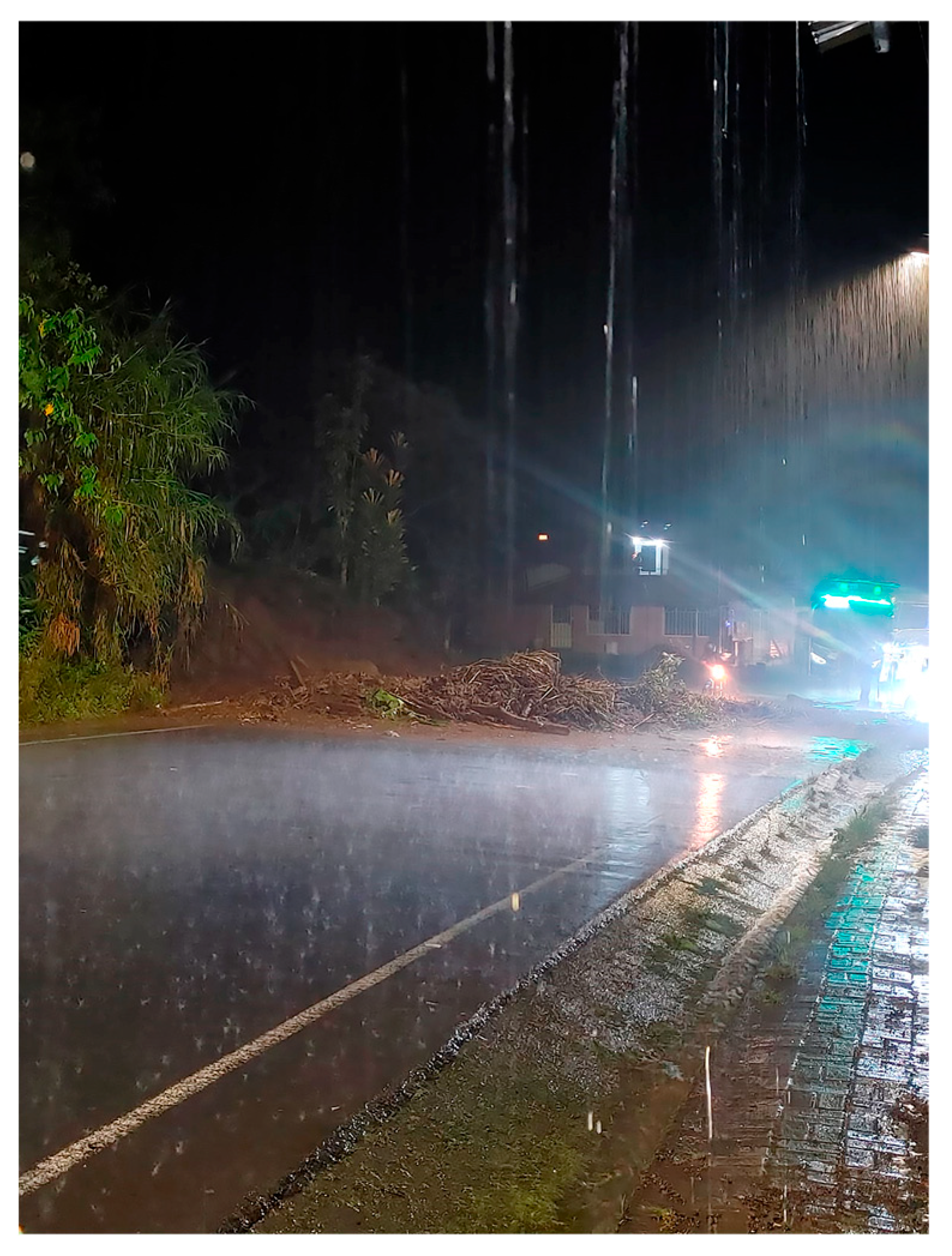
Due to the constant noise and water flooding on the street at the eastern edge of the El Placer community (which reached above people's feet), approximately 40 people gathered in a house in the western part of the community, near the sports fields. According to witnesses, this is a common practice that has been carried out on previous occasions, such as during earthquakes. However, it should be noted that this is not a formal evacuation process, nor are there any established procedures or prior coordination for such evacuations within the community.
At approximately 3:00 AM, the power supply was interrupted, and road communication was lost due to landslides in the San Jorge area, a hamlet located west of the described area.
In the early morning, the community cleared the road to allow passage for vehicles that were unable to travel due to the debris on the E30 Road. Around 5:00 AM, a large boulder (approximately 2 meters in diameter) destroyed the bus stop and caused the affected section of the road to shift due to the impact. This was followed by a mudflow that completely covered the road (Figure C2a–c), blocking the E30 Road in the El Placer area.
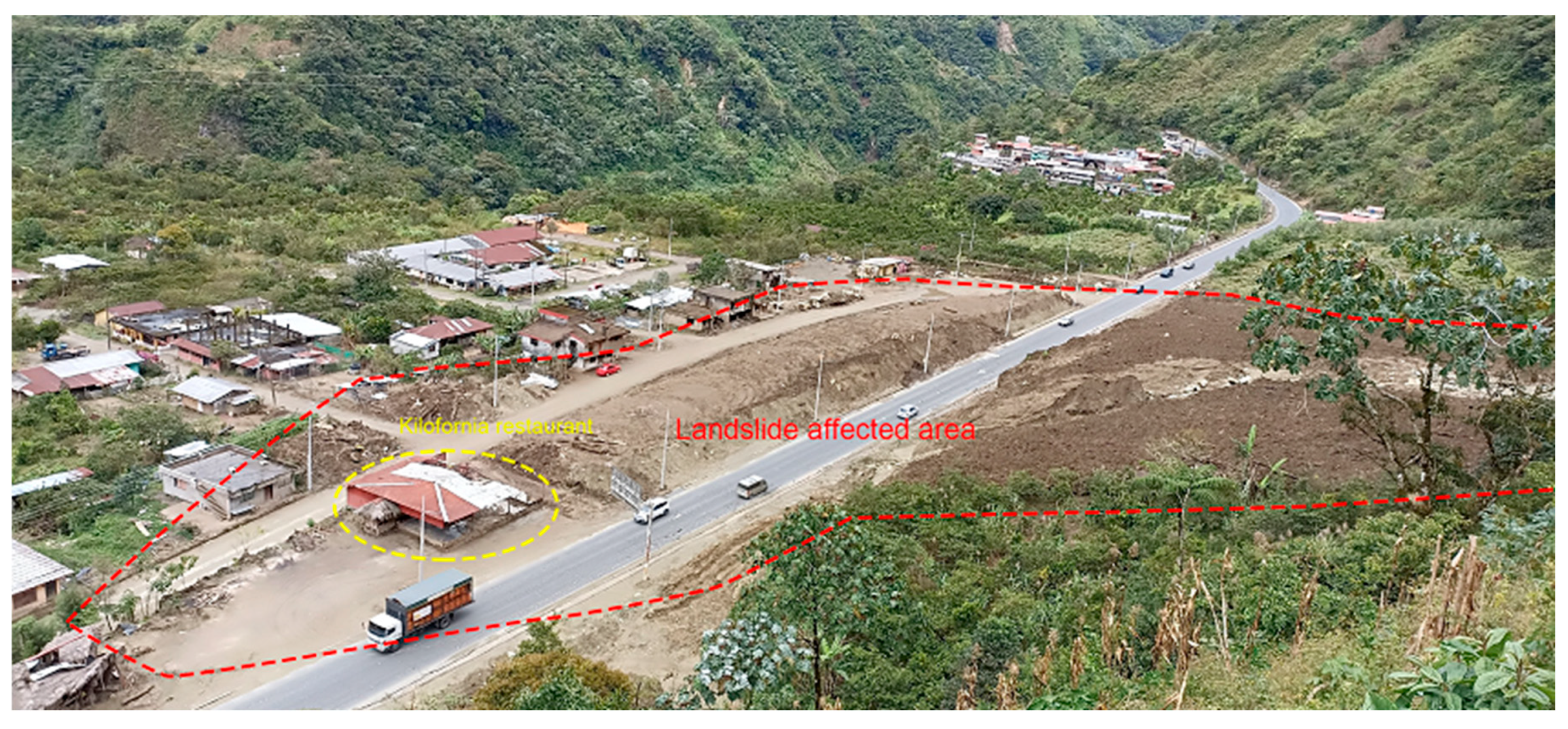
Between 8:45 and 9:00 AM, landslides occurred in the upper part of El Placer, followed by another mudflow that descended toward the entrance of the community. Several people who were in vehicles and unable to continue along the road parked in the parking lot of the Kilofornia restaurant (Figure C3) in Quilloturo, considered the safest point in the area. This decision was based on the common perception that the greatest concentration of material and flows occurred on the slopes located north of El Placer.
In summary, between the early morning of June 15 and the morning of June 16 (until 9:00 AM), the slopes and the road located north of El Placer were the areas most affected by different types of mass movements, generating a perception of greater risk in El Placer and of lesser exposure in Quilloturo.
Figure C2.
(a) Mudflow east of the block fall area shown in Figure xx, in front of the bus stop (west-east direction); (b) Picture showing the block that affected the El Placer bus stop; (c) Megablocks of sheared granodiorite on the E30 Road after the event.
Figure C2.
(a) Mudflow east of the block fall area shown in Figure xx, in front of the bus stop (west-east direction); (b) Picture showing the block that affected the El Placer bus stop; (c) Megablocks of sheared granodiorite on the E30 Road after the event.
The following details the information obtained from the residents of Quilloturo regarding the mass movements recorded during this event that affected the community (see the location of the towns in Figure 1 in the manuscript).
Between 3:00 and 4:00 AM, a small mudflow occurred in the Quilloturo ravine, affecting the E30 highway. At 9:00 AM, a larger volume of mud was observed in the Quilloturo ravine, and half an hour later, at 9:30 AM, the ravine had almost completely dried up.
“Darwin’s sister warns him to be careful because material is flowing down the ravine in front of El Placer. Darwin tells her he is calm because he can see that material is flowing down. However, he warns his sister to be careful because the mud-water flow in the Quilloturo ravine has stopped” (instructions and comments from a resident).
At 10:30 AM, a loud crash was heard inside the ravine, lasting approximately five seconds, and was described as similar to a structure breaking. Immediately afterward, eyewitnesses observed a dense fog in the upper part of the ravine that obscured visibility in that area, especially where the ravine changes direction. Below this fog (and before a bend), trees were seen falling, followed by a dark mass of debris that impacted the rocky area located above the community. The material was violently dispersed, opening like a fan (in the shape of an umbrella, according to the neighbors) of fragments and rocks that were projected in multiple directions.
"Several people who were standing on a corner looking toward the mountain, when the explosion hit, ran toward Quilloturo Street (where the projectiles landed), thinking the material was heading more toward El Placer" (comments from a resident).
The material that came down the ravine struck the road and an earthen wall located at the northern edge of the hamlet, which served as a boundary between the houses and the road. This impact generated a wave approximately 5 meters high and a shockwave (described by witnesses as a "gust of wind") that shattered windows, caused several people to lose their balance, and knocked them down, displacing some by as much as 3 meters.
In the apical or fan-shaped zone of the alluvial fan, where the slope of the ravine sharply decreases, two denser flows formed and collided, partially blocking the flow's advance in the flat area, the inhabited zone of Quilloturo. The confluence of these two flows was diverted toward the street located at the eastern end of this community.
The material comprising the mudslide (boulders, soil, and tree trunks), after colliding with the rock mid-slope and the wall adjacent to the road, was violently ejected southward. The fragments acted as projectiles, striking people attempting to evacuate southward along the main street of the hamlet, causing the deaths of five of them. Some of these fragments, with ballistic trajectories, reached a distance of approximately 60 meters from the edge of E30 Road (see Figure 14 in the manuscript).
West of Quilloturo, the area most affected by the mudflow was identified, characterized by the displacement of blocks up to 9 meters in diameter, which destroyed homes and other structures. According to witnesses, the houses were lifted and displaced by the mudslide. One of the most affected buildings was a two-story house located west of the Kilofornia restaurant (Figure C3), next to the highway, which was displaced approximately 8 meters from its base. In general, it was determined that the greatest impact was concentrated in the first row of houses located north and west of the hamlet of Quilloturo.
Figure C3.
Details of the area affected by the mudslide. Note that the accumulation of material is located west of the restaurant.
According to witnesses, all of these events occurred in less than a minute. Subsequently, the transported material had a higher water content, exhibiting mudflow behavior.
References
- Lavell, A. Riesgo, desastre y territorio. La necesidad de los enfoques regionales/transnacionales. Anuario Social y Político de América Latina y el Caribe. 2002, 5, p. 9.
- Aristizábal, E.; Martínez, H.; Vélez, J.I. Una Revisión Sobre El Estudio de Movimientos En Masa Detonados Por Lluvias. Rev. Acad. Colomb. Cienc. Ex. Fis. Nat. 2023, 34, 209–227. [CrossRef]
- Kjekstad, O.; Highland, L. Economic and Social Impacts of Landslides. In Landslides – Disaster Risk Reduction; Sassa, K., Canuti, P., Eds.; Springer Berlin Heidelberg: Berlin, Heidelberg, 2009; pp. 573–587 ISBN 978-3-540-69966-8.
- Sandoval-Díaz, J.; Martínez-Labrín, S. Gestión Comunitaria Del Riesgo de Desastre: Una Propuesta Metodológica-Reflexiva Desde Las Metodologías Participativas. REDER 2021, 5, 75. [CrossRef]
- Rodas Toral, R. Análisis de Susceptibilidad a Deslizamientos Aplicado a Grupos Socioeconómicos Vulnerables, Mediante Máxima Entropía (MaxEnt), En Las Parroquias: Cuenca, Nulti, Paccha, El Valle y Turi, Del Cantón Cuenca. Master Thesis, Universidad Andina Simón Bolívar. Quito, Ecuador, 2025.
- Loor Salazar, V.E.; Paucar Camacho, J.A.; Bravo Rosillo, N.G. Percepción del riesgo de la población ante amenazas de sismo, inundación y deslizamiento del cantón Portoviejo. Revista San gregorio. 2022, p. 18.
- Narváez, L.; Lavell, A.; Pérez Ortega, G. La Gestión Del Riesgo de Desastres: Un Enfoque Basado En Procesos. Comunidad Andina. Secretaría General Editions. Quito, Ecuador, 2009.
- Zevallos Moreno, O. Las amenazas hidrometeorológicas en Quito. In Gestión de riesgos en Quito; Carrión, A., Rebotier, J., Metzger, P., Puente Sotomayor, F., Eds.; IRD Éditions, Flacso Ecuador: Marseille, Marseille, 2024; pp. 70–91 ISBN 978-2-7099-3051-2.
- Wang, Y.; Wu, X.; Lin, G.; Peng, B. Deciphering the Social Vulnerability of Landslides Using the Coefficient of Variation-Kullback-Leibler-TOPSIS at an Administrative Village Scale. Remote Sensing 2025, 17, 714. [CrossRef]
- Varnes, D.J. Slope Movement Types and Processes. In Landslides—Analysis and control: National Research Council, Washington, D.C.; Special Report; Transportation Research Board: Washington, D.C., 1978; Vol. 176, pp. 11–33.
- Cruden, D.M.; Varnes, D.J. Landslide Types and Processes. In Landslides: Investigation and Mitigation; Transportation Research Board; Turner, A.K. and Shuster, R.L., Eds., 1996; Vol. 247, pp. 36–75.
- Carrión, A., Rebotier, J., Metzger, P., Puente-Sotomayor, F. Gestión de Riesgos En Quito. Balance y Perspectivas de Treinta Años de Estudios; 1st ed.; FLACSO Quito. Ecuador / IRD, 2024; ISBN 978-9978-67-690-5.
- D’Ercole, R.; Trujillo, M. Amenazas, Vulnerabilidad, Capacidades y Riesgos En El Ecuador. Los Desastres, Un Reto Para El Desarrollo.; COOPI, IRD y Oxfam.; Quito, 2003; ISBN 9978-42-972-7.
- Saito, S.M.; Dias, M.C.D.A.; Alvalá, R.C.D.S.; Stenner, C.; Franco, C.; Ribeiro, J.V.M.; Souza, P.A.D.; Santana, R.A.S.D.M. População Urbana Exposta Aos Riscos de Deslizamentos, Inundações e Enxurradas No Brasil. SN 2019, 31. [CrossRef]
- Pilatasig, L.; Ibadango, E.; Troncoso, L.; Mateus, A.; Alulema, R.; Alonso Pandavenes, O. Evaluación del deslizamiento Casual Nuevo Alausí y su zona de influencia; FIGEMPA - Universidad Central del Ecuador: Quito, Ecuador, 2023; p. 25;
- Valdés Carrera, A.C.; Mendoza, M.E.; Allende, T.C.; Macías, J.L. A Review of Recent Studies on Landslide Hazard in Latin America. Physical Geography 2023, 44, 243–286. [CrossRef]
- Troncoso, L.; Pilatasig, L.; Ibadango, E.; Mateus, A.; Bermeo, A. Evaluación de Susceptibilidad a Movimientos En Masa de Las Laderas y Taludes Relacionados Con El Sector de La Merced Hasta Quilloturo, y Su Zona de Influencia; Quito, Ecuador, 2024; p. 111;
- Ministerio de Agricultura y Ganadería Geoportal SigTierra-MAG. Sistema Nacional de Información de Tierras Rurales e Infraestructura Tecnológica 2010.
- Litherland, M.; Aspden, J.A.; Jemielita, R. The Metamorphic Belts of Ecuador; Overseas Memoir; 1a.; British Geological Survey: Keyworth, Nottingham, UK, 1994; Vol. 11; ISBN 0-85272-239-7.
- Mercier, J.; Vergely, P. Tectónica; 1a Edición en español.; Limusa: Mexico DC, 2001;
- Troncoso, L. El Podcast Como Estrategia Para Difundir El Conocimiento Comunitario Sobre Peligros Volcánicos. Master Thesis, Universidad Andina Simón Bolívar: Quito, Ecuador, 2022.
- GADP RioVerde Plan de Desarrollo y Ordenamiento Territorial 2019-2023; Gad Parroquial de Rio Verde: Baños de Tungurahua, 2018; p. 175;
- Secretaría de Gestión de Riesgos Informe de Situación - Época Lluviosa, Ecuador; Secretaría de Gestión de Riesgos: Quito, 2018; p. 15;
- El Telégrafo editorial La Carretera Baños-Puyo Se Abrió Tras 24 Horas Sin Lluvias. El Telegrafo 2018.
- Diarioderio Dos Fallecidos Por Aluvión En RíoVerde. El Diario de Riobamba 2018.
- EcoAmazónico Tristeza y Desconsuelo Por La Muerte de 3 Personas En El Placer. EcoAmazónico comunica y une voces 2022.
- Radio Baños Online Dos Fallecidos Por Aluvión En RíoVerde. Se Realizó Sobrevuelo de Reconocimiento En El Sector de Quilloturo. Radio Baños Online 2022.
- El Telégrafo editorial Cerrada La Vía Baños-Puyo Por Deslizamientos de Tierra. El Telegrafo 2022.
- Hungr, O.; Leroueil, S.; Picarelli, L. The Varnes Classification of Landslide Types, an Update. Landslides 2014, 11, 167–194. [CrossRef]
- LaHusen, S.R.; Grant, A.R.R. Complex Landslide Patterns Explained by Local Intra-Unit Variability of Stratigraphy and Structure: Case Study in the Tyee Formation, Oregon, USA. Engineering Geology 2024, 329, 107387. [CrossRef]
- Riemer, W.; Locher, T.; Núñez, I. Mechanics of Deep Seated Mass Movements in Metamorphic Rocks of the Ecuadorian Andes. In Proceedings of the Proceedings Of The Fifth International Symposium On Landslides; A.A. Balkema, Brookfield, Rotterdam: Laussane, Suiza, 1988; Vol. 1, pp. 307–310.
- Correa Campués, C.J. Análisis de La Susceptibilidad de Los Fenómenos de Remoción En Masa de La Carretera Loja-Zamora. Bachelor degree Thesis, Escuela Politécnica Nacional: Quito, Ecuador, 2007.
- Xiao, Y.; Tang, X.; Li, Y.; Huang, H.; An, B.-W. Social Vulnerability Assessment of Landslide Disaster Based on Improved TOPSIS Method: Case Study of Eleven Small Towns in China. Ecological Indicators 2022, 143, 109316. [CrossRef]
- Cardona, O.D. The Need for Rethinking the Concepts of Vulnerability and Risk from a Holistic Perspective: A Necessary Review and Criticism for Effective Risk Management. In Mapping Vulnerability: Disasters, Development and People; Routledge: London, UK, 2004; p. 256+ ISBN 978-1-84977-192-4.
- Van Westen, C.J.; Castellanos, E.; Kuriakose, S.L. Spatial Data for Landslide Susceptibility, Hazard, and Vulnerability Assessment: An Overview. Engineering Geology 2008, 102, 112–131. [CrossRef]
- García Acosta, V. El riesgo como construcción social y la construcción social de riesgos. Desacatos. 2005, pp. 11–24.
- Hernandez Cortes, N.L.; Ayala Macías, E. Resistir en el paisaje: voces y gestión de la comunidad ante los deslizamientos e inundaciones en la colonia Sánchez Taboada de Tijuana. DECUMANUS. Revista Interdisciplinaria sobre Estudios Urbanos. 2025, p. 32.
- Zúñiga Armjo, S. La memoria y resiliencia de habitantes de la comuna de Hualqui frente a desbordes del río Biobío. urbearq 2023, 93–110. [CrossRef]
- Pilatasig, L.; Torrijo, F.J.; Ibadango, E.; Troncoso, L.; Alonso-Pandavenes, O.; Mateus, A.; Solano, S.; Viteri, F.; Alulema, R. Casual-Nuevo Alausí Landslide (Ecuador, March 2023): A Case Study on the Influence of the Anthropogenic Factors. GeoHazards 2025, 6, 28. [CrossRef]
- Troncoso, L.; Torrijo, F.J.; Ibadango, E.; Pilatasig, L.; Alonso-Pandavenes, O.; Mateus, A.; Solano, S.; Cañar, R.; Rondal, N.; Viteri, F. Analysis of the Impact Area of the 2022 El Tejado Ravine Mudflow (Quito, Ecuador) from the Sedimentological and the Published Multimedia Documents Approach. GeoHazards 2024, 5, 596–620. [CrossRef]
- Valdés Carrera, A.C.; Mendoza, M.E.; Allende, T.C.; Macías, J.L. A Review of Recent Studies on Landslide Hazard in Latin America. Physical Geography 2023, 44, 243–286. [CrossRef]
- Fernández, M. ¿Cómo superar los retos de la vivienda rural en América Latina y el Caribe? ciudades Sostenibles 2023.
- Secretaría Nacional de Gestión de Riesgos SitRep N.01-Lluvias, 16 de Junio de 2024. Informe De Situación Cantonal Baños De Agua Santa; Monitoreo de Eventos Adversos; Secretaría Nacional de Gestión de Riesgos: Quito, 2024; p. 4;
- Secretaría Nacional de Gestión de Riesgos Informe de Análisis de Los Factores de Riesgo Presentes En Los Sectores El Placer y Quilloturo; Secretaría Nacional de Gestión de Riesgos: Quito, Ecuador, 2024; p. 72;
- Secretaría Nacional de Gestión de Riesgos SitRep N.32-Lluvias, 16 de Junio de 2024. INFORME DE SITUACIÓN CANTONAL BAÑOS DE AGUA SANTA; Monitoreo de Eventos Adversos; Secretaría Nacional de Gestión de Riesgos: Quito, 2024; p. 10;
- IIGE Informe de Asistencia Técnica de Emergencia Para El Levantamiento de Información Geológica, Fotogramétrica e Identificación de Movimientos En Masa En El Cantón Baños de Agua Santa, Provincia de Tungurahua; IIGE Instituto de Investigación Geológico y Energético: Quito, Ecuador, 2024; p. 26;
Figure 1.
Map location of the studied area. The red polygon delimits the affected and studied region. The occupied area of the communities is shaded in grey, and roads and streets are marked in black (UTM coordinates). Modified from [18].
Figure 1.
Map location of the studied area. The red polygon delimits the affected and studied region. The occupied area of the communities is shaded in grey, and roads and streets are marked in black (UTM coordinates). Modified from [18].
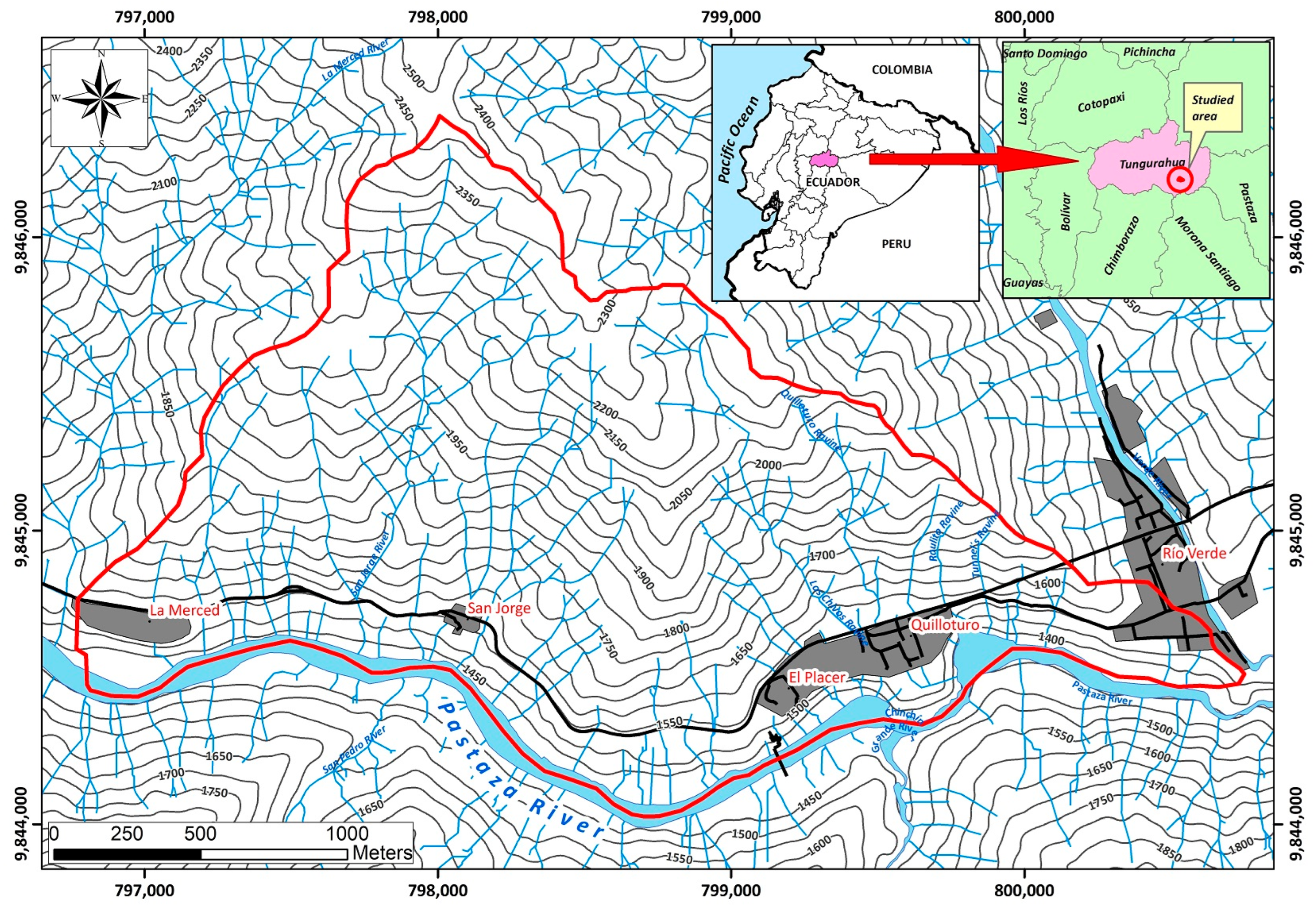
Figure 2.
Regional geological map related to the study area, which is enclosed in the black square. Modified from [19].
Figure 2.
Regional geological map related to the study area, which is enclosed in the black square. Modified from [19].
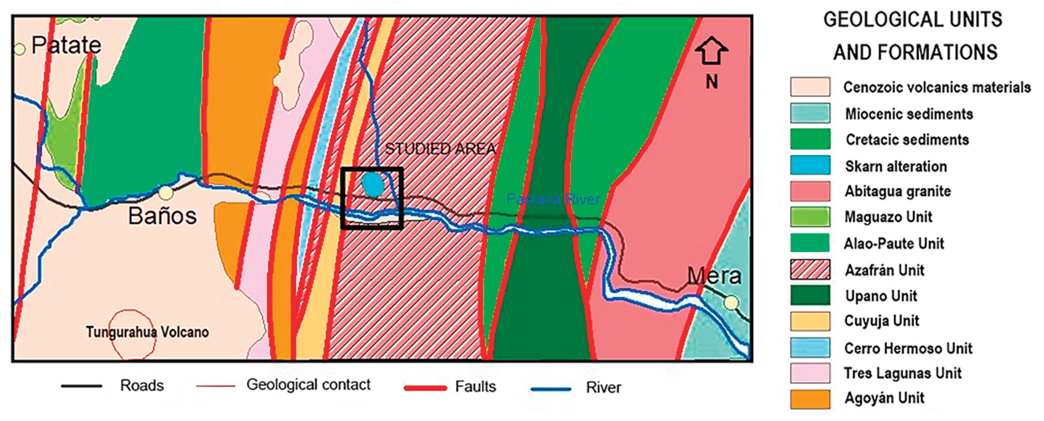
Figure 3.
Outcropping rocks and their structures: (a) Outcrop of granodiorite rock crossed by parallel, gently undulating, spaced planes related to shear cleavage; (b) Outcrop of metamorphic rocks exposed in the Puerta del Cielo sector (west of the study area) showing gently dipping and highly folded schistosity planes.
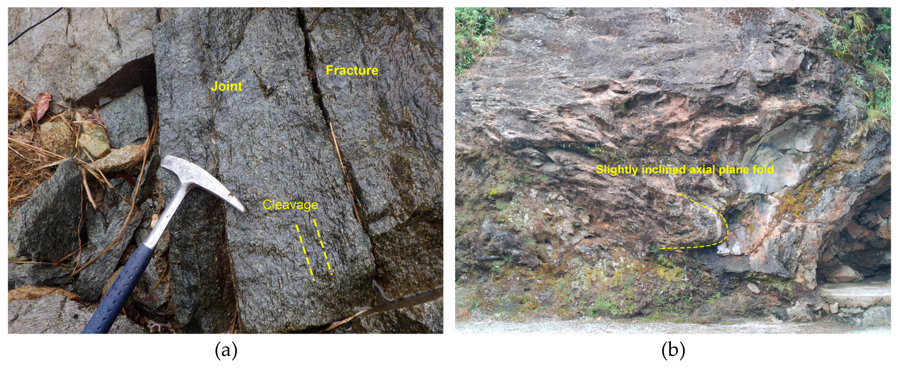
Figure 4.
(a) A picture of the southern slope of the hill located NE of the Agoyán dam, showing a partially eroded surface deposit from the last rainy season in June 2024, which was channeled through the drainage system to the Baños-Puyo road; (b) The retaining wall was destroyed by the impact of a flow (according to a resident of La Merced) composed of rock fragments such as gneiss or paragneiss.
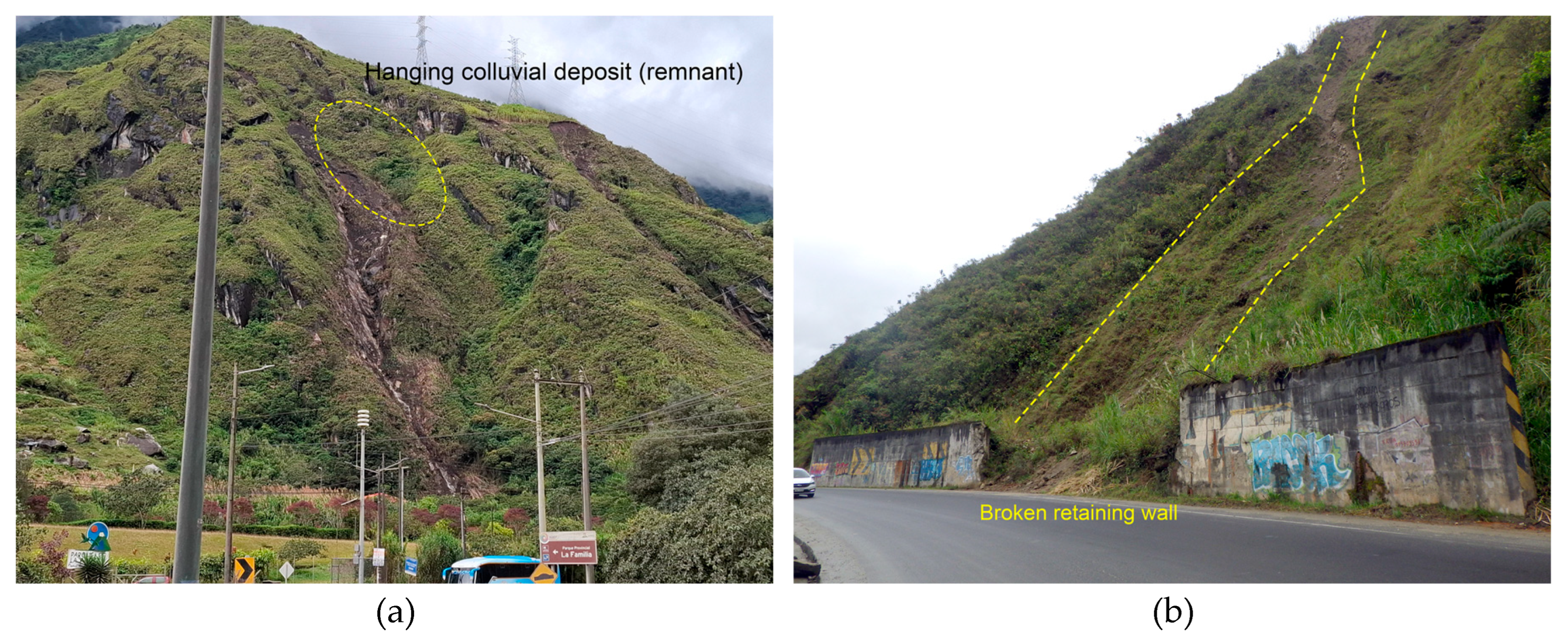
Figure 5.
(a) Some boulders settled at the toe of the landslide, which were embedded in the mudflow materials. The analyzed landslide materials comprised vegetal soil overburden, mud, alteration soil, and rocks, being a complex mass running downslope; (b) The effect of the 2018 mass movement in the El Placer area, where a bus and its passengers were towed down the slope of the road (modified from [25]).
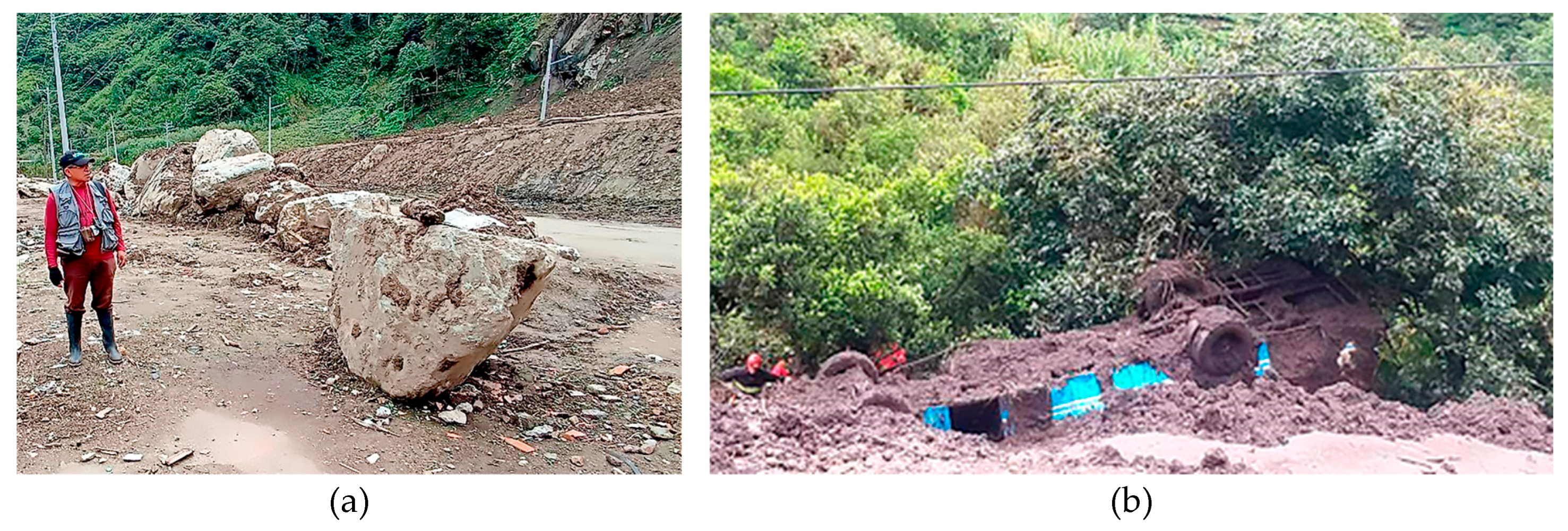
Figure 6.
(A) Alluvial-type mass movement generated on August 11, 2022, in the Los Chivos ravine (Modified from [27]). (B) Detail of the deposit generated by the mass movement of the same event as the previous one affecting the E-30 road and nearby houses (Modified from [28]).
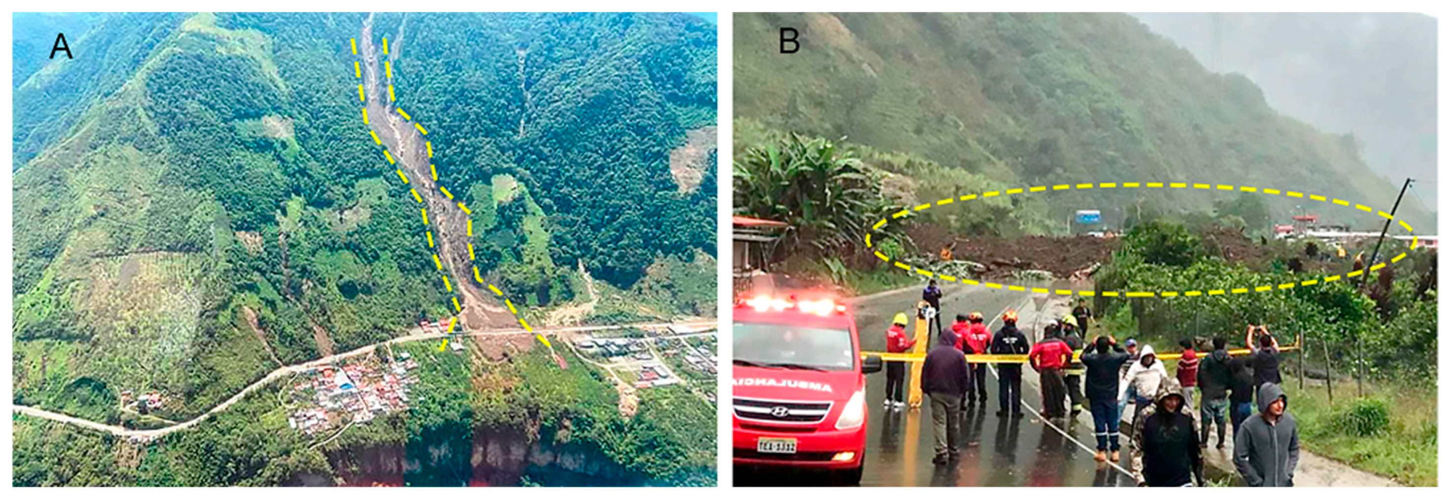
Figure 7.
(a) Interviews and development of group tasks for the residents of the El Placer hamlet; (b) Participatory exercise for the development of talking maps with the affected residents of Qui-lloturo.
Figure 7.
(a) Interviews and development of group tasks for the residents of the El Placer hamlet; (b) Participatory exercise for the development of talking maps with the affected residents of Qui-lloturo.
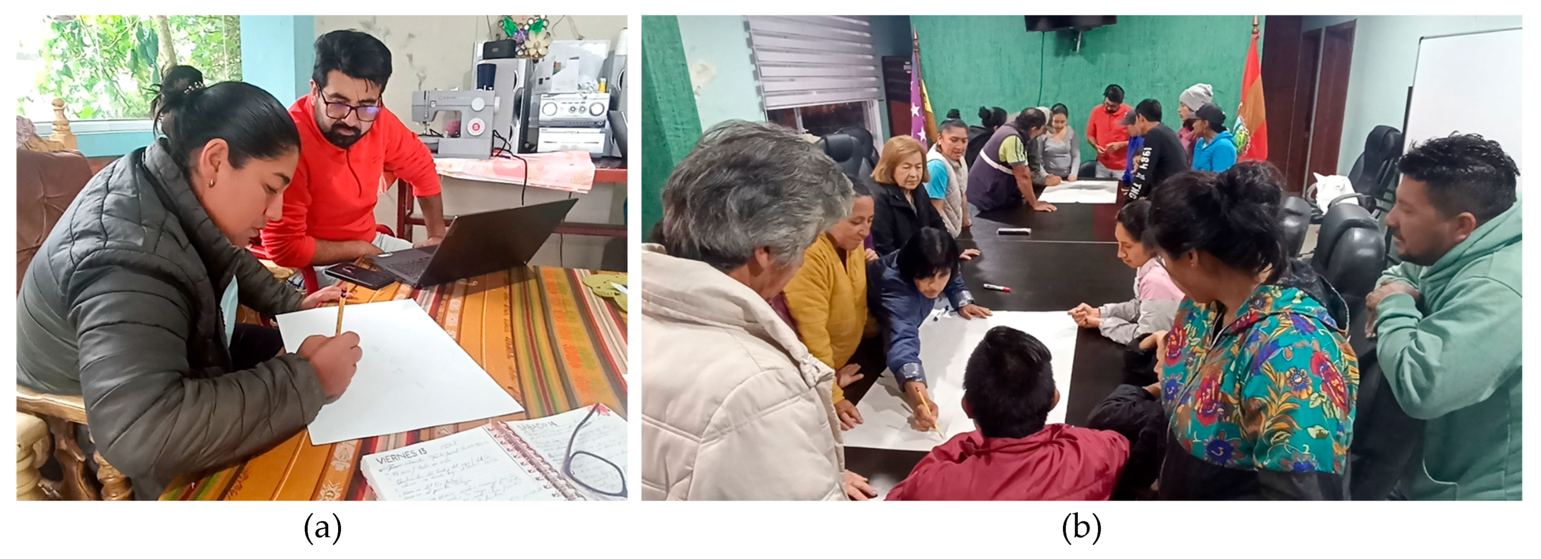
Figure 8.
A map detailing geographic and anthropogenic elements and the location of mass movements that occurred in the area of the hamlets of El Placer and Quilloturo. Prepared by a group of people from the Quilloturo community who participated in the Focus Group.
Figure 8.
A map detailing geographic and anthropogenic elements and the location of mass movements that occurred in the area of the hamlets of El Placer and Quilloturo. Prepared by a group of people from the Quilloturo community who participated in the Focus Group.
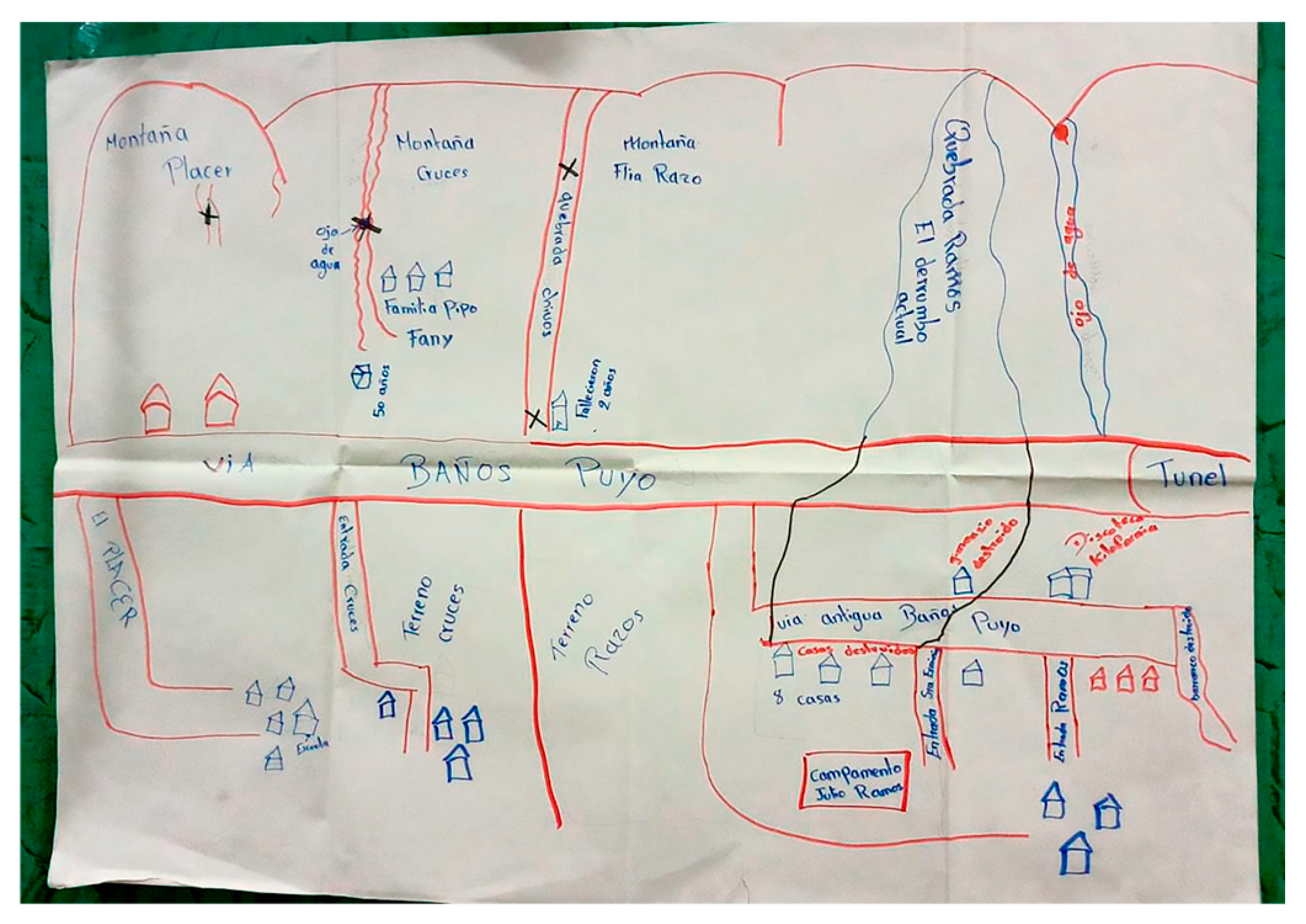
Figure 9.
(a) Image of a rock mass exposed northwest of Río Verde, showing thin, whitish layers interbedded with massive volcanic tuffs; (b) Remnant of colluvial deposit consisting of meter-sized blocks exposed on the left bank of Quebrada Quilloturo, part of which detached during the June 2024 event.
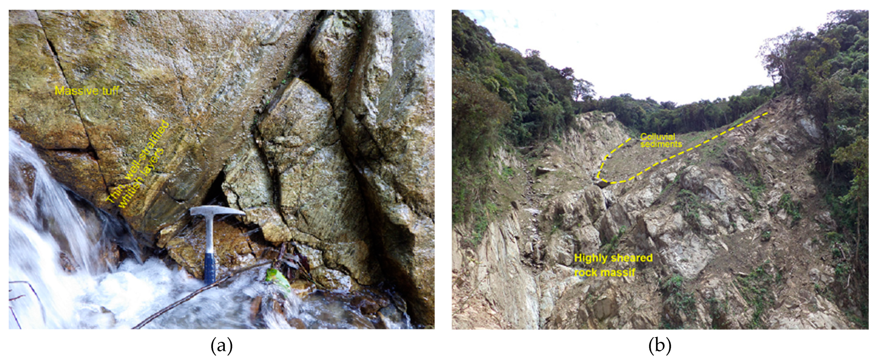
Figure 10.
(a) Outcrop of a shear belt or band showing intense deformation and remnants of the deformed rock, affecting granodiorites exposed along the Río Verde-Llanganates Road; (b) Megablocks of sheared granodiorite or diorite are exposed on a slope north of Quilloturo.
Figure 10.
(a) Outcrop of a shear belt or band showing intense deformation and remnants of the deformed rock, affecting granodiorites exposed along the Río Verde-Llanganates Road; (b) Megablocks of sheared granodiorite or diorite are exposed on a slope north of Quilloturo.
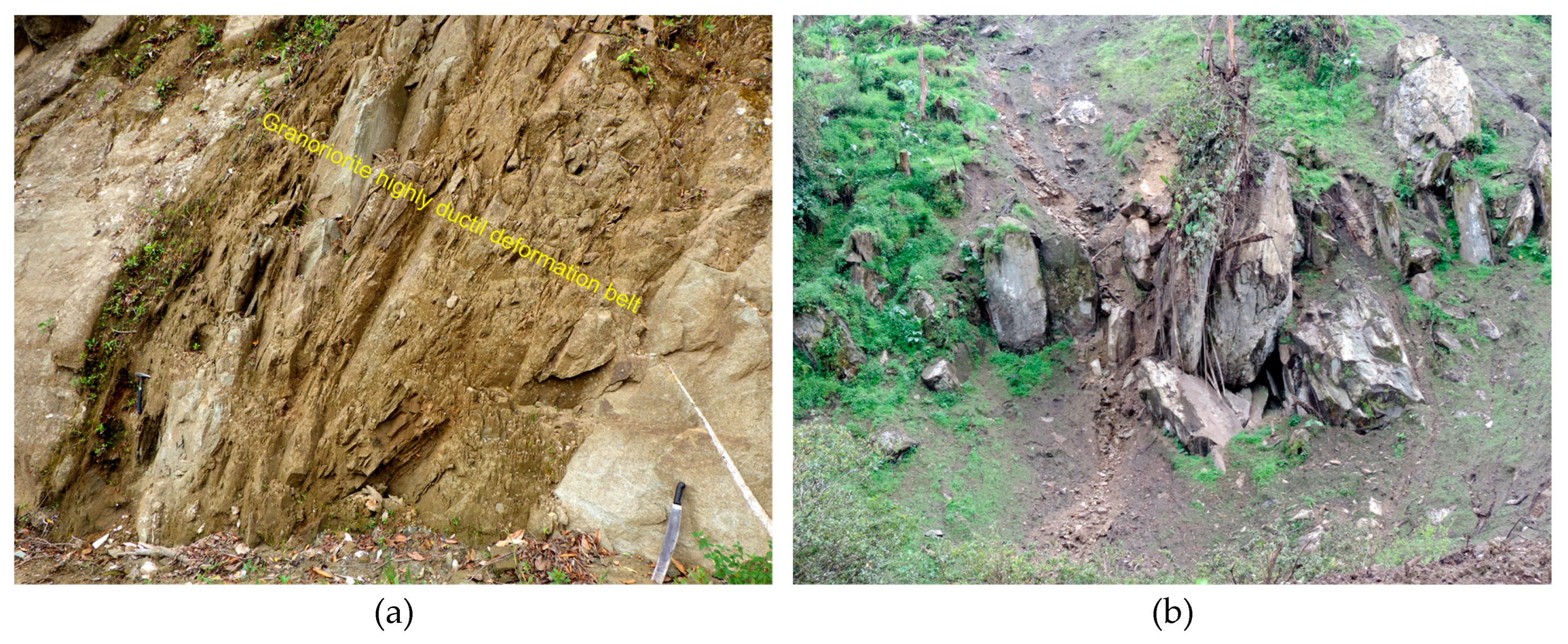
Figure 11.
Inventory map location of the mass movements into the studied area and its surroundings. It is also indicated the principal escarpments and the investigation points where samples or data were acquired (UTM coordinates). Modified from [18], and aerial photographs.
Figure 11.
Inventory map location of the mass movements into the studied area and its surroundings. It is also indicated the principal escarpments and the investigation points where samples or data were acquired (UTM coordinates). Modified from [18], and aerial photographs.
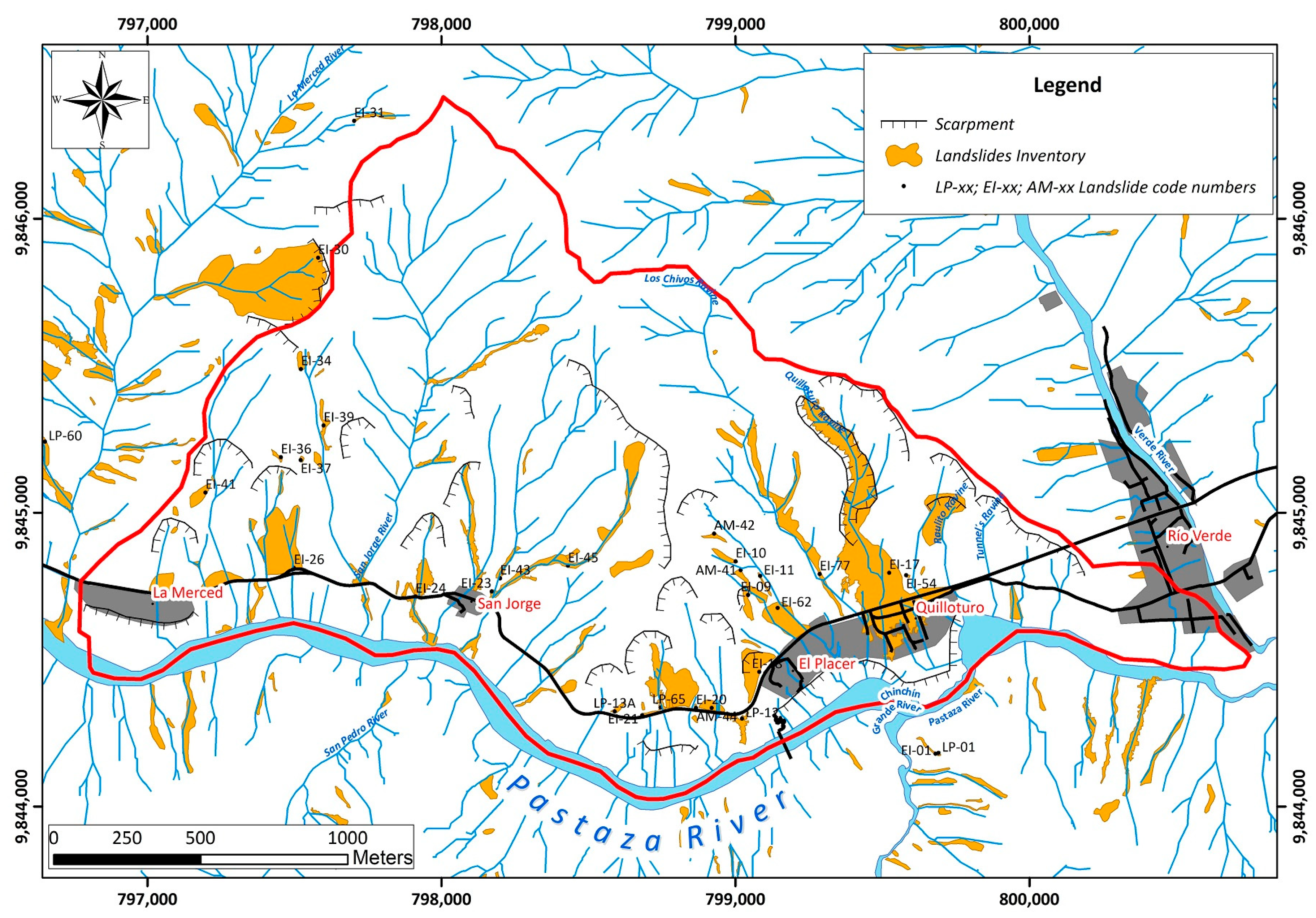
Figure 12.
Panoramic view of several boulders on the E-30 road. The big one has a diameter of more than 9 m (June, 2024 event).
Figure 12.
Panoramic view of several boulders on the E-30 road. The big one has a diameter of more than 9 m (June, 2024 event).
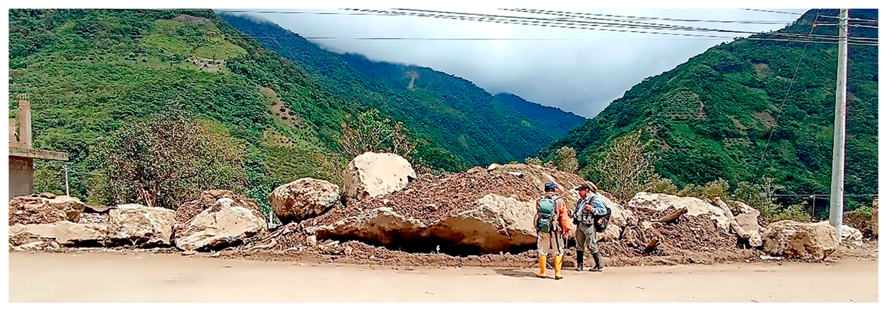
Figure 13.
Fallen boulders and ballistics. Distribution map and location of boulder accumulation along the E-30 Road inside the studied area.
Figure 13.
Fallen boulders and ballistics. Distribution map and location of boulder accumulation along the E-30 Road inside the studied area.
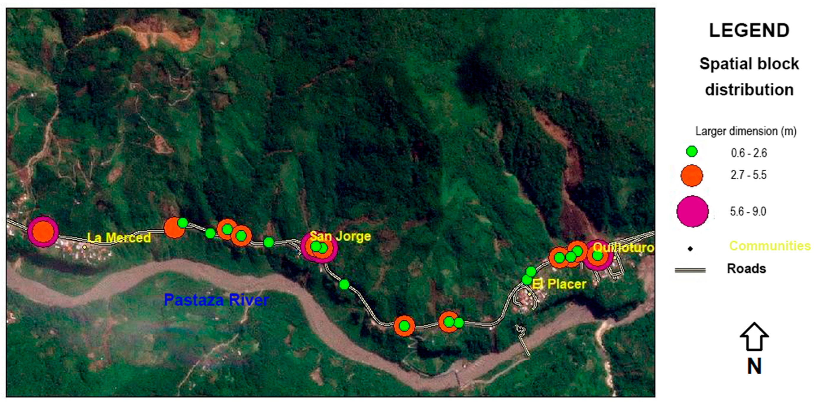
Figure 14.
Map showing the zonation of the different phenomena, deposits, and materials related to the complex mass movement that impacted Quilloturo on the morning of June 16, 2024. See explanation in the text. (Modified from [18]).
Figure 14.
Map showing the zonation of the different phenomena, deposits, and materials related to the complex mass movement that impacted Quilloturo on the morning of June 16, 2024. See explanation in the text. (Modified from [18]).
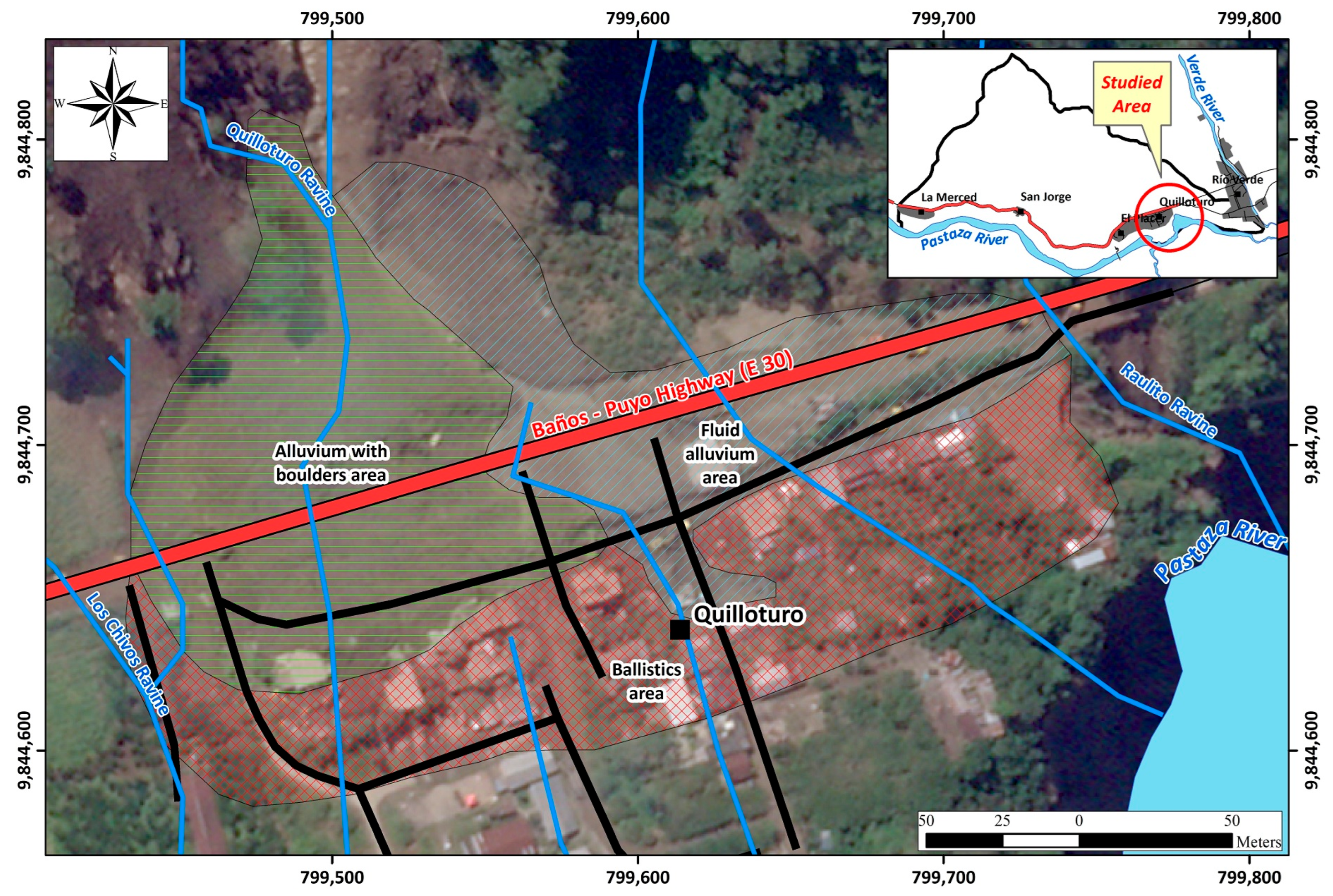

Table 1.
Type of landslides and their characteristics verified in the field.
| Code | Type of slide | Area (m2) | Direction | Inclination (º) | State of activity | Height (m) | Length (m) | Wide (m) | Thickness (m) |
|---|---|---|---|---|---|---|---|---|---|
| EI-77 | Debris flow | 18816.6 | 150 | 12 | Pendent | 15.0 | 1.0 | 1.0 | |
| EI-17 | Debris flow | 98676.2 | 165 | 12 | Pendent | 15.0 | 25.0 | 3.0 | |
| LP-65 | Debris flow | 5931.7 | 175 | Active | |||||
| LP-12 | Rotational | 2387.7 | 175 | Active | 2.0 | ||||
| EI-24 | Debris flow | 9153.8 | 180 | 50 | Pendent | 1.0 | 2.0 | ||
| LP-60 | Mud flow | 6578.9 | 145 | Active | 35.0 | 15.0 | |||
| EI-31 | Rock and debris flow | 1620.4 | 250 | 35 | Pendent | 1.0 | 2.0 | ||
| EI-30 | Rotational | 79174.3 | 210 | 28 | Pendent | 5.0 | 1.0 | 4.0 | |
| EI-34 | Earth and debris flow | 1333.1 | 170 | 45 | Active | 1.0 | 1.0 | 2.0 | 1.0 |
| EI-39 | Debris flow | 1861.5 | 190 | 27 | Pendent | 1.0 | 5.0 | ||
| EI-41 | Translational | 2621.0 | 180 | 35 | Pendent | 5.0 | 3.0 | ||
| EI-37 | Earth and debris flow | 198.9 | 180 | 40 | Active | 3.0 | 5.0 | 2.0 | 3.0 |
| EI-36 | Earth and debris flow | 480.0 | 215 | 50 | Active | 1.0 | 1.0 | 5.0 | 1.0 |
| EI-26 | Earth and debris flow | 24710.4 | 170 | 47 | Pendent | 5.0 | 4.0 | ||
| LP-13A | Avalanche | 620.2 | 235 | 35 | Active | 4.0 | 5.0 | ||
| EI-21 | Earth and debris flow | 416.3 | 235 | 65 | Active | 4.0 | 5.0 | ||
| AM-44 | Rotational | 2156.2 | 190 | Inactive | 3.0 | 9.0 | 15.0 | ||
| AM-42 | Translational | 806.8 | 120 | Active | |||||
| EI-11 | Debris flow | 478.3 | 150 | 35 | Pendent | 1.0 | 8.0 | ||
| AM-41 | Translational | 2741.1 | 150 | Active | |||||
| EI-18 | Earth and debris flow | 9345.7 | 343 | 47 | Pendent | 1.0 | 25.0 | ||
| EI-50 | Earth and debris flow | 3395.0 | 70 | 60 | Pendent | 15.0 | 25.0 | ||
| EI-10 | Earth and debris flow | 1452.6 | 130 | 28 | Active | 5.0 | 2.0 | ||
| EI-20 | Earth and debris flow | 99.3 | 180 | 35 | Pendent | 3.0 | 15.0 | 5.0 | |
| EI-01 | Earth and debris flow | 625.4 | 285 | 48 | Active | 5.0 | 5.0 | ||
| LP-01 | Avalanche | 53.9 | 225 | Active | 1.0 | 8.0 | |||
| EI-54 | Debris flow | 123.1 | 165 | 18 | Pendent | 5.0 | |||
| EI-53 | Earth and debris flow | 8116.6 | 192 | 35 | Pendent | 5.0 | 2.0 | ||
| EI-23 | Debris flow | 365.6 | 220 | 30 | Pendent | 1.0 | |||
| EI-43 | Earth and debris flow | 1654.1 | 188 | 74 | Active | 3.0 | 2.0 | ||
| EI-45 | Debris flow | 17565.6 | 280 | 35 | Pendent | 2.0 | 2.0 | ||
| EI-09 | Old landslide | 2291.0 | 135 | 28 | Inactive | 1.0 | 5.0 | ||
| EI-62 | Translational | 9950.9 | 130 | 35 | Pendent | 3.0 | 5.0 | 2.0 | |
| LP-60A | Translational | 3827.2 | 170 | Active | 16.0 | 25.0 |
1 The direction is indicated in degrees from magnetic north. Inclination in degrees from vertical direction.
Disclaimer/Publisher’s Note: The statements, opinions and data contained in all publications are solely those of the individual author(s) and contributor(s) and not of MDPI and/or the editor(s). MDPI and/or the editor(s) disclaim responsibility for any injury to people or property resulting from any ideas, methods, instructions or products referred to in the content. |
© 2025 by the authors. Licensee MDPI, Basel, Switzerland. This article is an open access article distributed under the terms and conditions of the Creative Commons Attribution (CC BY) license (https://creativecommons.org/licenses/by/4.0/).
Copyright: This open access article is published under a Creative Commons CC BY 4.0 license, which permit the free download, distribution, and reuse, provided that the author and preprint are cited in any reuse.


