
Submitted:
30 October 2025
Posted:
31 October 2025
You are already at the latest version
Abstract
Liepāja Lake, a Natura 2000 protected area and one of the largest coastal freshwater bodies in Latvia, has been historically influenced by urbanization, diffuse agricultural inputs, and legacy contamination from metallurgy and ship-repair industries. Comprehensive, spatially explicit data on its sediment and water chemistry have previously been lacking. This dataset provides an openly accessible record of major and trace element concentrations in surface sediments and surface waters collected during the 2024 field campaign. Sampling sites were distributed across northern, central, and southern zones to capture gradients in anthropogenic pressure and natural variability. Water samples were filtered and acidified following ISO 15587-2:2002, while sediments were homogenized, sieved, and digested following and EPA 3051a. Both matrices were analyzed using Inductively Coupled Plasma Mass Spectrometry (ICP-MS, Agilent 8900 ICP-QQQ) with multi-element calibration traceable to NIST standards. The dataset comprises 31 analytes (Li–Bi) with paired standard deviation values, reported in mg kg⁻¹ (sediments) and µg L⁻¹ (water). Rigorous validation included certified reference materials, duplicates, blanks, and statistical outlier screening. The resulting data form a reliable geochemical baseline for assessing pollution sources, quantifying spatial heterogeneity, and supporting future monitoring, modelling, and restoration efforts in climate-sensitive Baltic coastal lakes.
Keywords:
Liepāja Lake
; trace elements
; heavy metals
; ICP-MS
; geospatial dataset
; Natura 2000
; environmental monitoring
; anthropogenic impact
; legacy contamination
1. Summary
Liepāja Lake, situated in western Latvia, is one of the largest coastal freshwater bodies in the Baltic region and is designated as a Natura 2000 protected area owing to its unique biodiversity and ecological significance. The lake has been historically impacted by industrial activities, urban effluents, and diffuse agricultural pollution, leading to sediment and water contamination by nutrients and trace metals. Despite its environmental importance, comprehensive, georeferenced chemical data for this ecosystem have been scarce.
The present dataset provides an openly accessible, spatially explicit record of major and trace element concentrations in surface sediments and surface waters collected during the 19 July 2024 field campaign. Sampling locations were selected to represent diverse hydro morphological and impact zones, including historical discharge areas, inflow sectors, and open-water regions. Each point is documented in both the LKS-92 and WGS84 coordinate systems, ensuring full compatibility with national and international spatial databases.
Analytical data include thirty-one elements (Li, Na, Mg, Al, Fe, Ni, Cu, Zn, As, Cd, Pb, and others) with paired standard deviation values, allowing quantitative assessment of spatial heterogeneity and data reproducibility. The dataset forms a reference baseline for detecting spatial and temporal changes in contamination patterns and provides a foundation for future environmental monitoring, modelling, and restoration activities in the context of climate-driven hydrological changes.
The study was performed as part of unfunded institutional collaboration promoting sustainable water and sediment management in Latvia. Public dissemination of this dataset is expected to strengthen regional environmental research capacity, support policy implementation under the EU Water Framework Directive, and stimulate further investigations on pollution trends and ecological recovery in Natura 2000 aquatic ecosystems.
2. Data Description
2.1. Overview of Files and Format
The dataset comprises two Microsoft Excel files in .xlsx format:
Each file includes a single worksheet with a consistent tabular structure. All data are numeric (floating-point, float64) except for identifiers and coordinate labels (string type, object). The tables can be read in any spreadsheet or data-analysis environment (e.g., Microsoft Excel, R, Python pandas). All element concentrations are reported in SI-compatible units: (1) mg kg⁻¹ for sediments (solid phase); (2) µg L⁻¹ for water (liquid phase). Each analyte has a paired standard deviation column (“SD, mg/kg” or “SD, µg/L”) reflecting replicate analytical uncertainty.
2.2. Sediment Dataset
This file contains 13 sampling records (in point Liepaja_Lake_1 sampling was unsuccessful) and 68 columns. It provides spatially explicit measurements of major and trace elements in surface sediments collected across Liepāja Lake on 19 July 2024 [1]. Table 1 summarizes the structure of the sediment dataset, listing the key column groups, coordinate fields, and analytical variables with corresponding units and example values. Each record corresponds to a unique sampling station with complete geospatial and chemical metadata, enabling reproducible spatial analysis and cross-comparison with the water dataset.
Spatial coordinates and concentration units allow immediate mapping and statistical evaluation without conversion.
2.3. Water Dataset
This file contains 14 sampling records and 68 columns describing chemical composition of surface-water samples collected at corresponding lake sites on 19 July 2024 [2]. Table 2 summarizes the structure of the surface-water dataset, indicating the coordinate fields, analytical variables, and example units. Each record represents a single monitoring point with complete spatial referencing and paired concentration precision data, facilitating integration with the sediment dataset for geochemical and hydrological assessments of Liepāja Lake.
All numeric fields can be imported directly for multivariate analysis or visualization. The coordinate fields enable spatial linkage with the sediment dataset or external GIS layers.
2.4. Reading and Interpreting the Data
Each row represents a unique sampling location. Columns are paired variable + SD structures, so statistical users should treat SD columns as measurement-error estimates rather than independent variables. Missing or not detected values are recorded as empty cells (NA) to maintain numerical compatibility. To merge both matrices, the field Sampling point provides the common key.
3. Methods
3.1. Sampling Area
The Liepāja Lake is located in southwestern Latvia (56°23′–56°32′ N, 21°00′–21°06′ E) within the Baltic Lowland (see Figure 1) and forms part of Liepāja Lake Nature Reserve, a Specially Protected Nature Area (Natura 2000 site code LV0507800). The territory is included in the list of internationally important bird areas (IBA). It is the fifth-largest lake in Latvia, covering approximately 37.2 km² with an average depth of 1.5 m and a maximum depth of around 3.0 m. The lake is a shallow coastal lagoon-type water body, separated from the Baltic Sea by a narrow sandy barrier and hydrologically connected through natural and artificial channels.
The mean annual air temperature in the Liepāja region is approximately +7.0 to +7.5 °C, with January averages around –2 °C and July averages near +17 °C. The frost-free period typically extends from mid-April to late October. Ice formation in the lake usually begins in December and may persist until March, although in recent years, the duration and thickness of ice cover have shown a decreasing trend due to regional climate warming.
The mean annual precipitation is about 700–750 mm, of which approximately 65–70% occurs during the warm season (April–October). Rainfall is evenly distributed, but summer convective events can cause short-term increases in runoff from urban and agricultural areas surrounding the lake. The average annual potential evapotranspiration is estimated at 500–550 mm, resulting in a positive water balance under normal hydrological conditions.
Wind is a major hydrodynamic driver in the shallow lake system. Dominant winds from the southwest and west (average 4–6 m s⁻¹) induce water-level fluctuations of up to 0.5 m and promote strong mixing and sediment resuspension. These processes influence both the distribution of suspended solids and the vertical gradients of dissolved oxygen and nutrients.
The lake receives inflows primarily from the Bārta River in the south and the Alande River in the north, with additional drainage inputs from surrounding polder systems. Outflow occurs through the Tosmare Channel, which enables limited exchange with the Baltic Sea during periods of elevated water levels or strong westerly winds. Hydrological conditions are strongly influenced by precipitation and wind-induced mixing, which drive high spatial variability in turbidity, oxygen regime, and sediment resuspension.
The catchment area 2580 km² includes agricultural lands, forested areas, and the urban territory of Liepāja City, which hosts residential, port, and industrial zones. Historically, the northern part of the lake was affected by discharges from metallurgy, mechanical engineering, and ship-repair industries. Wastewaters containing heavy metals (Fe, Cu, Zn, Pb, Ni, Cr) and oil-derived pollutants were released through drainage channels and stormwater systems into the northern lake basins. Sediment cores collected in this area indicate accumulated legacy contamination from that period, forming a geochemical imprint distinguishable from natural background concentrations.
Although industrial activities have been significantly reduced since the 1990s, residual contamination persists in some northern sediments, especially near the Alande River inflow, airport drainage channels, and former industrial reservoirs. Ongoing ecological restoration efforts aim to stabilize these sediments, reduce pollutant mobility, and enhance overall ecosystem resilience through improved water level management, nutrient control, and reed bed rehabilitation.
Ecologically, Liepāja Lake supports a mosaic of aquatic and semiaquatic habitats, including EU Habitats Directive type 3140 – Hard oligo-mesotrophic waters with benthic vegetation of Chara spp., as well as extensive reed stands (Phragmites australis) and shallow vegetated zones. The lake provides important breeding, feeding, and resting grounds for several bird species of European conservation significance, such as Botaurus stellaris (Eurasian bittern), Larus ridibundus (Black-headed gull) and Porzana porzana (spotted crake).
3.2. Sampling Design
Sampling locations were established in accordance with Natura 2000 conservation priorities and the biodiversity protection objectives. The sampling sites were selected based on the management measures outlined in the area’s nature conservation plan and the identified potential sources of historical pollution. The spatial distribution of the points was designed to encompass the northern, central, and southern zones of the lake, thereby representing distinct hydrological and ecological gradients. This layout ensures coverage of both anthropogenically influenced areas (e.g., river inflows, polder outlets, recreational zones) and reference sites with minimal human impact, thus capturing the full range of natural variability and potential contaminant inputs across the lake system. Table 3 summarizes the spatial distribution and ecological characteristics of 15 monitoring points across Liepāja Lake, covering both protected and anthropogenically influenced areas.
3.3. Sample Collection and Handling
At each sampling station, surface water samples were collected prior to sediment sampling to prevent resuspension of bottom material and eliminate cross-contamination between matrices. All field operations were conducted under the quality management system of an ISO/IEC 17025 accredited laboratory [3], following the procedures defined in ISO 5667-4:2016 [4] for surface water and ISO 5667-12:2017 [5] for sediment sampling in lakes.
Water was sampled from the upper 0.3–0.5 m layer using precleaned high density polyethylene bottles, previously rinsed with 10% HNO₃ (Suprapur® grade) and deionized water (18.2 MΩ cm). Prior to filling, each bottle was triple rinsed with the ambient water at the site.
Following water collection, surface sediments (0–20 cm depth) were sampled using a plastic piston-type coring system or Ekman grab sampler designed for fine-grained materials [6]. The uppermost 20 cm was targeted because, in shallow and wind-exposed coastal Latvian lakes such as Liepāja, the surficial layer is commonly well mixed, sandy, and characterized by low organic matter accumulation [7,8]. Sediment samples were carefully transferred with acid-washed plastic spatulas into airtight polyethylene bags, sealed, and stored in a cool box maintained at 4 ± 2 °C. Metallic tools were strictly avoided to prevent trace metal contamination.
All samples were clearly labeled with unique station identifiers, sampling date and time, operator initials, and coordinates recorded in both WGS 84 (EPSG: 4326) and LKS-92 / TM (EPSG: 3059) coordinate systems. Positioning accuracy was verified using a calibrated GNSS receiver (± 3 m). Chain-of-custody documentation accompanied each sample batch from field to laboratory to ensure traceability.
Upon arrival at the laboratory, samples were inspected for integrity, logged into the Laboratory Information Management System, and stored under controlled temperature conditions until further pre-treatment and analysis.
3.4. Laboratory Preparation and Analysis
All laboratory work was performed under the quality system of an ISO/IEC 17025-accredited laboratory, following internal standard operating procedures harmonized with EPA 3051a [9] for acid digestion of sediments and ISO 17294-2:2016 [10] for element determination by ICP-MS.
Upon receipt, sediment samples were inspected for container integrity and logged into the Laboratory Information Management System (LIMS). Samples were then air-dried at room temperature (20–25 °C) in a contamination controlled environment, homogenized, and sieved through a 2 mm stainless steel mesh to isolate the fine fraction (< 2 mm). Approximately 0.50 ± 0.01 g of dry, homogenized sediment was accurately weighed into Teflon digestion vessels. Each sample was subjected to microwave-assisted acid digestion using a mixture of concentrated HNO₃ and HCl (9 mL + 3 mL) in accordance with ISO 15587-2:2002. The digestion was performed in a closed-vessel system (Milestone START E, or equivalent) at 180 °C for 45 min to ensure complete mineralization of the matrix. After cooling, digestates were quantitatively transferred to volumetric flasks and diluted to 50 mL with deionized water (18.2 MΩ cm).
Water samples were filtered through 0.45 µm membrane filters (cellulose-acetate, pre-rinsed with sample water) using a portable filtration unit operated in a contamination-free environment. The filtrates were acidified in the field to pH < 2 using ultrapure nitric acid (HNO₃, trace-metal grade) to stabilize dissolved metals. Filtered and acidified water samples required no additional digestion. Prior to instrumental analysis, samples were equilibrated to room temperature and mixed thoroughly.
Both sediment and water samples were analyzed using Inductively Coupled Plasma – Mass Spectrometry (ICP-MS, Agilent 8900 ICP-QQQ) equipped with a Micro-Mist nebulizer and operated in helium collision/reaction mode to reduce polyatomic interferences. Calibration curves were established using multi-element standards traceable to NIST covering the expected concentration range for each analyte. Internal standards (Sc, Ge, Rh, Ir, and Bi) were automatically introduced via online addition to correct for matrix effects and instrumental drift.
Instrument performance was verified at the start of each analytical sequence through calibration verification standards, and analytical blanks were measured every ten samples to confirm absence of carry-over. The limit of detection (LOD) for each element was calculated as three times the standard deviation of procedural blanks.
Concentrations were reported as mg kg⁻¹ for sediments (dry weight basis) and µg L⁻¹ for water samples. Analytical precision, expressed as standard deviation (SD) for each analyte, is included in the published dataset.
3.5. Validation and Quality Control
Analytical quality assurance was implemented under the framework of the laboratory’s ISO / IEC 17025:2017 accreditation and in compliance with ISO 17294-2:2016 for the determination of trace elements by ICP-MS. Comprehensive validation and control procedures were applied to ensure the accuracy, precision, and comparability of analytical results across both sediment and water matrices.
Each analytical batch included procedural blanks, duplicate samples, and Certified Reference Materials (CRMs) matched to the sample matrix (e.g., IAEA-336, LGC6016 Trace Elements in Natural Water). These controls were used to assess contamination, recovery efficiency, and instrument stability. Analytical precision was calculated for each element and expressed as the standard deviation (SD), which is reported in the dataset as a separate companion column.
Method detection limits (MDLs) were determined as three times the standard deviation of the procedural blanks (3σ rule), while limits of quantification (LOQs) were defined as ten times this value. Calibration linearity (R² ≥ 0.999) was verified for all analytes, and drift was monitored using internal standards introduced continuously during measurement.
Approximately 10% of all samples were analyzed in randomized replicates to estimate within-batch repeatability. Inter-matrix comparisons between water and sediment datasets were conducted to evaluate potential systematic bias in concentration trends and to confirm data coherence.
All measurement results were reviewed by a senior analyst prior to approval and release. Instrument performance, calibration validity, and blank responses were documented in the laboratory’s quality records to ensure traceability and reproducibility of the analytical process.
3.6. Data Curation and Validation
Raw analytical data generated by the ICP-MS system were automatically exported from the instrument software (Agilent MassHunter) into structured tabular format (.csv). The exported files were subjected to a multi-stage verification and cleaning process designed to ensure analytical integrity, traceability, and full reproducibility of the dataset.
All results were first screened for outliers, non-detects, and instrumental noise using control limits derived from quality control samples and procedural blanks. Values below the respective method detection limits (MDLs) were replaced by the symbolic flag <LOD (limit of detection). Geospatial coordinates recorded in both WGS 84 (EPSG:4326) and LKS-92 / TM (EPSG:3059) systems were checked for internal consistency and verified against the official Liepāja Lake Management Plan GIS layers to ensure positional accuracy.
All concentration fields were harmonized to uniform units—µg L⁻¹ for water and mg kg⁻¹ (dry weight) for sediment data. The dataset was further validated through a series of logical consistency tests, including verification that:
- (i)
- all paired standard-deviation (SD) values were non-negative;
- (ii)
- no missing coordinate pairs occurred; and
- (iii)
- analyte totals and ratios were within plausible environmental ranges.
Quality controlled data were then compared against reference background concentrations for Baltic lowland lakes to identify potential anomalies or anthropogenic enrichments. Statistical screening employed box-plot analysis, interquartile-range (IQR) filters, and z-score normalization to detect extreme outliers, which were reviewed manually but not removed unless justified by analytical documentation.
The final curated dataset was validated through visual inspection of spatial distributions in GIS to confirm geographic coherence of sampling points. Once all checks were completed, the verified dataset was archived in machine-readable format and deposited in the open repository under a Creative Commons Attribution (CC BY 4.0) license to enable unrestricted reuse, citation, and integration into future hydrological or geochemical studies.
Author Contributions
Conceptualization, I.G., U.V. and J.PU.; methodology, I.G. and N.S.; software, M.N.; validation, J.G., G.V. and I.B.; formal analysis, M.B.; laboratory analysis, M.B.; investigation — fieldwork, I.B., I.G. and U.V.; resources, U.V.; data curation, I.G.; writing—original draft preparation, I.G. and I.B.; writing—review and editing, N.S.; visualization, M.N.; supervision, V.G.; project administration, U.V.; funding acquisition, U.V. All authors have read and agreed to the published version of the manuscript.
Funding
This research received no external funding.
Institutional Review Board Statement
NA.
Informed Consent Statement
NA.
Data Availability Statement
The original data presented in the study are openly available in Mendeley Data at DOI: 10.17632/9wwnmzy7d7.1 https://data.mendeley.com/datasets/9wwnmzy7d7/1 and DOI: 10.17632/tgn7n436hd.1 https://data.mendeley.com/datasets/tgn7n436hd/1.
Conflicts of Interest
The authors declare no conflicts of interest.
Abbreviations
The following abbreviations are used in this manuscript:
| CC BY 4.0 | Creative Commons Attribution 4.0 International License |
| CRM | Certified Reference Material |
| GIS | Geographic Information System |
| GNSS | Global Navigation Satellite System |
| ICP-MS | Inductively Coupled Plasma Mass Spectrometry |
| ISO | International Organization for Standardization |
| LKS-92 | Latvian Coordinate System 1992 |
| LOD | Limit of Detection |
| LOQ | Limit of Quantification |
| LIMS | Laboratory Information Management System |
| MDL | Method Detection Limit |
| QA/QC | Quality Assurance and Quality Control |
| SD | Standard Deviation |
| WGS84 | World Geodetic System 1984 |
References
- Grinfelde, I. Chemical Element Concentrations in Liepāja Lake (Latvia) Sediments, 24; Mendeley Data, V1, 2025. 20 August. [CrossRef]
- Grinfelde, I. Chemical Element Concentrations in Liepāja Lake (Latvia) Water Samples, 24; Mendeley Data, V1, 2025. 20 August. [CrossRef]
- ISO/IEC 17025:2017; General Requirements for the Competence of Testing and Calibration Laboratories. International Organization for Standardization: Geneva, Switzerland, 2017.
- ISO 5667-4:2016; Water Quality—Sampling—Part 4: Guidance on Sampling from Lakes, Natural and Man-Made. International Organization for Standardization: Geneva, Switzerland, 2016.
- ISO 5667-12:2017; Water Quality—Sampling—Part 12: Guidance on Sampling of Bottom Sediments from Rivers, Lakes and Estuarine Areas. International Organization for Standardization: Geneva, Switzerland, 2017.
- Glew, J.R.; Smol, J.P.; Last, W.M. Sediment core collection and extrusion. In Tracking Environmental Change Using Lake Sediments. Volume 1: Basin Analysis, Coring, and Chronological Techniques; Last, W.M., Smol, J.P., Eds.; Kluwer Academic Publishers: Dordrecht, The Netherlands, 2021; pp. 73–105. [Google Scholar]
- Stivrins, N.; Briede, A.; Steinberga, D.; Jasiunas, N.; Jeskins, J.; Kalnina, L.; Maksims, A.; Rendenieks, Z.; Trasune, L. Natural and Human-Transformed Vegetation and Landscape Reflected by Modern Pollen Data in the Bore-onemoral Zone of Northeastern Europe. Forests 2021, 12, 1166. [Google Scholar] [CrossRef]
- Stivrins, N. Non-pollen palynomorphs from 78 surface sediment samples reveal spatial distribution of phytoplankton in Latvian lakes and ponds. Estonian Journal of Earth Sciences 2023, 72, 226–235. [Google Scholar] [CrossRef]
- U.S. EPA. Method 3051A (SW-846): Microwave Assisted Acid Digestion of Sediments, Sludges, and Oils, Revision 1 ed; Washington, DC, 2007. [Google Scholar]
- ISO 17294-2:2016; Water Quality—Application of Inductively Coupled Plasma Mass Spectrometry (ICP-MS)—Part 2: Determination of Selected Elements Including Uranium Isotopes. International Organization for Standardization: Geneva, Switzerland, 2016.
Figure 1.
Liepaja Lake with points of water and sediment sampling.
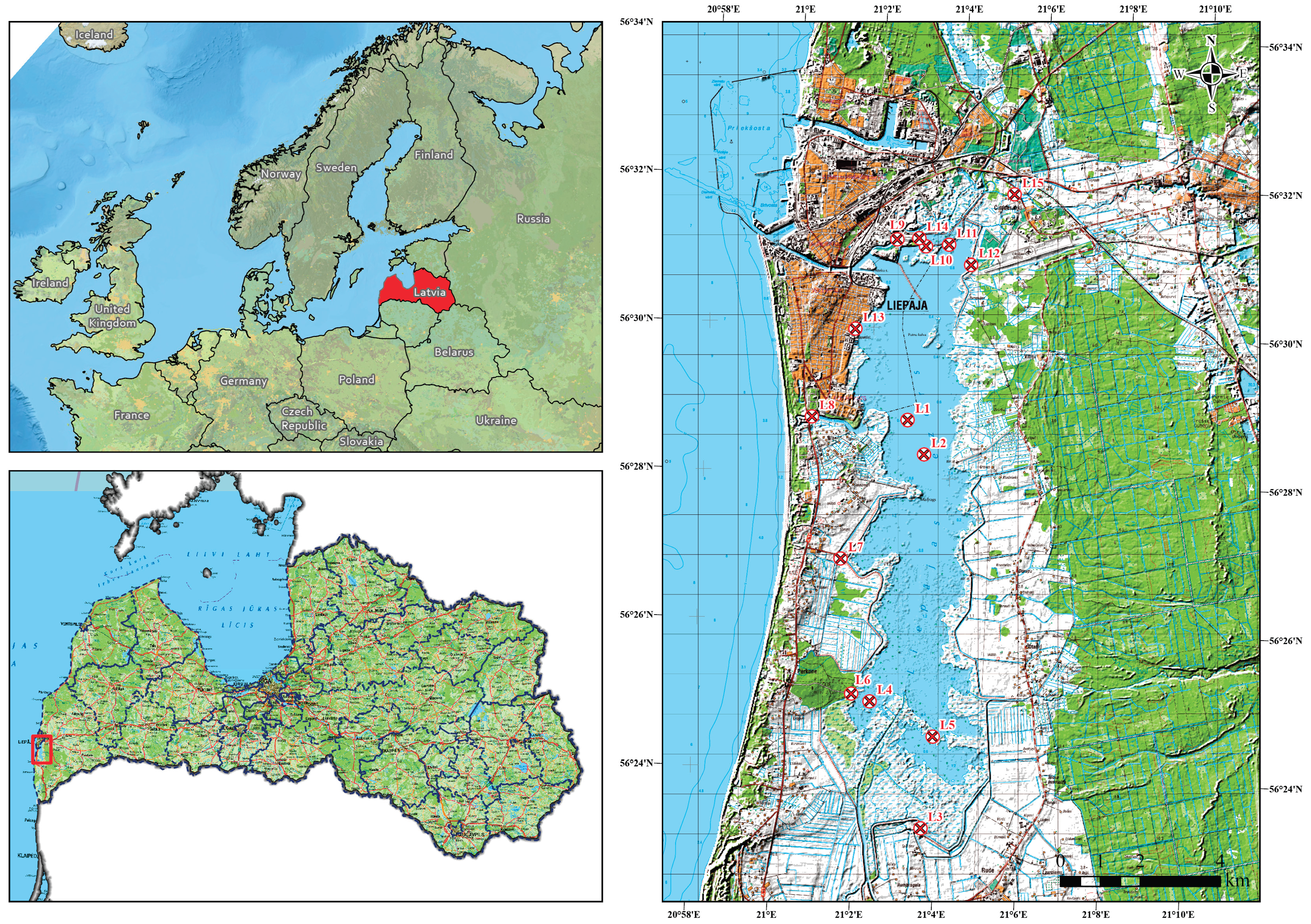

Table 1.
Structure and content of the sediment dataset file.
| Column Group | Description | Example Values |
| Sampling point | Unique site identifier (e.g., Liepaja_Lake_2) | Liepaja_Lake_2 |
| X_lks92_m, Y_lks92_m | Planar coordinates in the Latvian national grid (LKS-92, EPSG:3059); metres | 318 652.3, 262 490.2 |
| lat_WGS84_deg, lon_WGS84_deg | Geographic coordinates in decimal degrees (WGS 84) | 56.4719, 21.0558 |
| Lake Sediments sample Nr. | Internal laboratory ID | LS_02 |
| Element columns | Concentrations of 31 elements: Li, B, Na, Mg, Al, P, K, Ca, Ti, V, Cr, Mn, Fe, Co, Ni, Cu, Zn, Ga, Ge, As, Se, Rb, Sr, Mo, Cd, Sn, Sb, Ba, Hg, Pb, Bi (all in mg kg⁻¹) | e.g., Li = 17.3 mg kg⁻¹ |
| SD columns | Standard deviation for each element | SD(Li) = 0.66 mg kg⁻¹ |
Table 2.
Structure and content of the water dataset file.
| Column Group | Description | Example Values |
| Sampling point | Site identifier (e.g., Liepaja_Lake_1) | Liepaja_Lake_1 |
| X_lks92_m, Y_lks92_m | LKS-92 coordinates (m) | 318 248.8, 263 351.1 |
| lat_WGS84_deg, lon_WGS84_deg | WGS 84 decimal-degree coordinates | 56.4795, 21.0487 |
| Water Sample | Laboratory ID | W_01 |
| Element columns | Concentrations of 31 elements: Li, B, Na, Mg, Al, P, K, Ca, Ti, V, Cr, Mn, Fe, Co, Ni, Cu, Zn, Ga, Ge, As, Se, Rb, Sr, Mo, Cd, Sn, Sb, Ba, Hg, Pb, Bi reported in µg L⁻¹ | e.g., Li = 10.4 µg L⁻¹ |
| SD columns | Standard deviation for each element (µg L⁻¹) | SD(Li) = 0.45 µg L⁻¹ |
Table 3.
Description of monitoring and sampling points in Liepāja Lake.
| Point ID | Lake Zone | Environmental Context | Ecological/Management Notes |
| L1 | South | Inflow zone of the Bārta River | Dynamic hydrological area with fine suspended sediments; low organic content, transitional between freshwater inflow and brackish influence. |
| L2 | Central | Central basin near the national surface-water monitoring point | Represents open-water conditions with minimal shoreline disturbance; used for long-term hydrochemical calibration. |
| L3 | South | Rumba polder pumping station area | Southern boundary of the Natura 2000 site; subject to periodic pumping operations influencing sediment resuspension. |
| L4 | South-West | Border of EU Habitat 3140 | Seasonal access restriction; expected natural background composition of chemical elements. |
| L5 | South-East | Inner bay section with restricted access | Represents minimally impacted conditions; reference point for natural sediment geochemistry. |
| L6 | South-West | Periphery near boating cooperative | Anthropogenic influence from local boating activities and small drainage inflows. |
| L7 | West | Western boundary of the protected area, near Reina polder pumping station | Seasonal restriction; potential minor impact from polder drainage. |
| L8 | West | Outside protected area, recreational zone | Anthropogenic influence dominated by boating, fishing, and stormwater runoff. |
| L9 | North-West | Within boating cooperative near industrial park | Rainwater inflow from adjacent industrial areas; moderate anthropogenic pressure. |
| L10 | North | Northern boundary of EU Habitat 3140 | Historical contamination zone; influence from legacy industrial activities. |
| L11 | North | Alande River inflow zone | Active inflow bringing suspended matter and historical pollutants from upstream catchment. |
| L12 | North-East | Drainage channel in front of Liepāja Airport | Area influenced by airport runoff; potential for trace-metal enrichment. |
| L13 | North-West | Near northern urban shoreline | Exposed to diffuse urban runoff; local enrichment by surface inflows and sediments. |
| L14 | North-West | Former industrial freshwater reservoirs | Historical infrastructure with low current flow; sediments represent past industrial activity. |
| L15 | North-East | Alande River upstream of protected area | Reference inflow site characterizing background water composition prior to entering the lake. |
Disclaimer/Publisher’s Note: The statements, opinions and data contained in all publications are solely those of the individual author(s) and contributor(s) and not of MDPI and/or the editor(s). MDPI and/or the editor(s) disclaim responsibility for any injury to people or property resulting from any ideas, methods, instructions or products referred to in the content. |
© 2025 by the authors. Licensee MDPI, Basel, Switzerland. This article is an open access article distributed under the terms and conditions of the Creative Commons Attribution (CC BY) license (http://creativecommons.org/licenses/by/4.0/).
Copyright: This open access article is published under a Creative Commons CC BY 4.0 license, which permit the free download, distribution, and reuse, provided that the author and preprint are cited in any reuse.


