
Submitted:
15 October 2025
Posted:
27 October 2025
You are already at the latest version
Abstract
Land consolidation plays a crucial role in improving agricultural mechanization by optimizing land use efficiency, reducing transportation distances, and enhancing the operational viability of mechanized farming. This study evaluates the effects of land consolidation on key mechanization indicators in Türkiye, focusing on Kırşehir Province over a 13-year period (2010–2022). By integrating official statistics, field data, and variance-based statistical methods, changes in tractor density, average parcel size, tractor power per hectare, and the number of implements per tractor were analyzed before and after consolidation. The results indicate that land consolidation significantly increased parcel sizes and contributed to the use of stronger, more modern machinery. Additionally, thematic maps were utilized to visually support the spatial aspects of consolidation, although no GIS-based analysis was performed. These findings highlight the importance of aligning land consolidation policies with mechanization strategies to foster more sustainable and efficient agricultural systems.
Keywords:
agricultural mechanization
; land consolidation
; GIS analysis
; tractor density
; sustainable agriculture
; Türkiye
1. Introduction
The fragmentation of agricultural lands has long been recognized as one of the major challenges limiting efficient and sustainable agricultural development, especially in developing countries like Türkiye. Increasing population and limited arable land have made it vital to optimize the use of existing farmland. One of the most widely adopted strategies to address land fragmentation and enhance productivity is land consolidation (LC), which aims to reduce the number of scattered parcels and increase average parcel size [1,2,3].
In Türkiye, land consolidation has a long-standing legal and institutional background. First introduced in 1961, the policy was revised in 1984 and again in 2005, becoming a core component of the national agricultural modernization agenda [1]. Early studies emphasized the positive impact of LC on agricultural enterprises, highlighting how larger and more consolidated fields improve operational efficiency and productivity by reducing the number of parcels per farmer [2].
LC plays a vital role in supporting agricultural mechanization, a key driver of productivity growth in agriculture [4,5,6]. Mechanized operations such as plowing, sowing, harvesting, and irrigation are more efficient when performed on larger, regularly shaped, and road-accessible parcels. Furthermore, LC facilitates better alignment with modern infrastructure, including irrigation systems, thereby promoting the efficient use of water and soil resources [3,7].
The synergy between land consolidation and mechanization leads not only to improvements in agricultural efficiency but also contributes to reduced input costs, time savings, lower fuel consumption, and reduced labor requirements [4,8,9]. For instance, Maklavani et al. [5] found that integrating LC with mechanization substantially enhances productivity and environmental sustainability, especially in paddy production. Similar findings were reported in case studies such as the Çanakkale-Biga-Dereköy LC project, which demonstrated measurable improvements in land productivity and energy efficiency at the local level [3].
Despite these benefits, LC must be implemented with caution. Potential social and ecological impacts—such as reduced community interaction and biodiversity loss—must be carefully considered [11,12]. Hence, LC should not be seen merely as a technical intervention but rather as a comprehensive rural development tool requiring inclusive planning, robust legal frameworks, and strong community engagement.
This study aims to evaluate the impact of land consolidation on parcel structure, mechanization efficiency, and overall agricultural productivity in a selected rural region of Türkiye. The results are expected to contribute to both academic literature and practical policymaking in sustainable agricultural land management.
2. Materials and Methods
2.1. Study Area
This study was conducted in Kırşehir Province, situated in the Central Anatolia Region of Türkiye. With an area of approximately 6,570 km², the province is composed largely of cultivable agricultural land, representing a significant portion of the region’s economic and social structure. According to the Turkish Statistical Institute (TURKSTAT), as of 2022, over 55% of the province’s land is classified as arable [16].
Kırşehir features a continental climate, characterized by hot, dry summers and cold winters with relatively low annual precipitation, which heightens the importance of irrigation infrastructure in agricultural production [17]. These climatic and topographic conditions directly influence both land use patterns and the choice of agricultural machinery, particularly in dryland farming zones.
As part of efforts to address issues related to land fragmentation, improve irrigation efficiency, and enable effective mechanization, land consolidation (LC) projects were initiated by the General Directorate of State Hydraulic Works (DSİ) beginning in 2010 [1]. These projects have been widely implemented across different villages and agricultural basins within Kırşehir. The consolidation activities included reorganizing parcel boundaries, constructing farm roads and irrigation canals, and digitizing land records [2,13].
The spatial data for this study were primarily obtained from official project reports, consolidation maps, and field observations. The analysis focuses on regions where consolidation was completed between 2010 and 2020, covering representative samples from central and rural areas of the province. The goal of these efforts was not only to improve production efficiency, but also to support sustainable rural development and reduce the operational costs of small-scale farming [3,5].
Visual comparisons of pre- and post-consolidation maps (Figure 1) illustrate notable improvements in parcel size, shape regularity, and machinery accessibility. Prior to LC, many parcels were irregularly shaped and poorly connected to infrastructure. After LC, farmers benefited from more compact and regularly aligned plots, which increased the mechanization suitability, reduced field operational time, and contributed to more rational land use [4,6,13].
According to Özgünaltay-Ertuğrul et al. [13], the mechanization level in Kırşehir has notably improved following LC projects, with the average number of parcels per enterprise significantly decreasing. This outcome aligns with national trends where consolidation has contributed to higher tractor power usage, reduced fuel consumption per hectare, and better utilization of modern agricultural implements [4,5,7,8].
In summary, Kırşehir provides a typical case study of rural Anatolian regions undergoing transformation through government-led land consolidation programs. Its agricultural base, mechanization characteristics, and consolidation history make it suitable for evaluating the relationship between land structure optimization and mechanical efficiency improvements.
2.2. Data Collection
The data used in this study were obtained from various official and field-based sources to ensure comprehensive analysis and accuracy:
- Turkish Statistical Institute (TURKSTAT): Supplied annual statistical data on agricultural mechanization indicators such as tractor density (tractors per 1000 hectares), average farm size (ha/farm), and tractor power (kW/ha) between 2010 and 2022 [13].
- General Directorate of Agricultural Reform (GDAR): Provided detailed project-level data related to land consolidation initiatives in Kırşehir, including project initiation dates, project status, consolidated area sizes, and the number of involved villages [12].
- Land Registry and Cadastre General Directorate: Delivered historical cadastral maps and land records showing pre- and post-consolidation parcel configurations, which were used to analyze changes in average parcel size and distribution [14].
- State Hydraulic Works (DSİ): Supplied project documentation, implementation records, and village-level consolidation statistics to verify field-level applications in the region [15].
- Field Data: Historical LC records, semi-structured farmer interviews, and local observations were incorporated to provide qualitative insights into land accessibility and the use of mechanization tools.
Additionally, Geographic Information Systems (GIS) tools were used to process and visualize spatial data related to the distribution of agricultural parcels and land consolidation boundaries. The maps utilized in the study were pre-generated and scale-free (non-scaled), serving to support visual interpretation rather than quantitative spatial analysis [17].
These data sources supported a longitudinal evaluation of agricultural mechanization indicators before and after land consolidation efforts in Kırşehir between 2010 and 2022. For instance, Table 1 presents trends in the number of tractors, tractor density, and cultivated area per tractor, while Table 2 highlights the number and variety of implements per tractor, reflecting the diversity and capacity of mechanization in the province.
2.3. Analysis Methods
2.3.1. Evaluation of Parcel Size Changes
To evaluate the impact of land consolidation on agricultural mechanization, changes in the average parcel size (ha/farm) before and after LC projects were analyzed. Data from the Land Registry and Cadastre Directorate were used, including cadastral records and historical land maps [14]. The mean parcel size was calculated for the pre-consolidation and post-consolidation periods.
2.3.2. Statistical Comparison of Mechanization Indicators
To assess the relationship between land consolidation and agricultural mechanization, the following indicators were examined [5,6,18]:
Parcel size (ha/farm)
Tractor density (tractors per 1000 ha)
Number of implements per tractor
Descriptive statistics were used to interpret these indicators across years. A paired t-test was applied to determine whether observed changes before and after land consolidation were statistically significant.
2.4. Research Hypothesis
To evaluate the impact of land consolidation on agricultural mechanization, the following hypotheses were formulated:
- H₀ (Null Hypothesis): Land consolidation has no statistically significant impact on agricultural mechanization indicators such as parcel size, tractor density, and equipment availability.
- H₁ (Alternative Hypothesis): Land consolidation significantly improves agricultural mechanization by increasing parcel size and enhancing access to tractors and equipment.
These hypotheses were evaluated through descriptive statistics and paired t-tests applied to mechanization indicators before and after consolidation.
3. Results
The results of this study focus on the effects of land consolidation on key agricultural mechanization indicators, including parcel size, tractor density, and the number of agricultural implements per farm.
3.1. Changes in Parcel Size
The impacts of land consolidation on the parcel structure in the villages of Karaduraklı, Yeşilli, and Büyükkobak in Kırşehir Province are illustrated in Figure 2, Figure 3 and Figure 4. These cadastral maps clearly demonstrate the transformation of land structure before and after consolidation. As observed, the number of parcels significantly decreased across all villages, while the average parcel size increased. Additionally, the geometry of the parcels improved substantially, becoming more regular and rectangular, which is more suitable for modern agricultural practices.
Similar improvements in parcel shape and size, contributing to more efficient tractor usage and reduced operational complexity, were also reported by Yıldız and Demirtaş [21], who highlighted the positive impact of land consolidation on tractor maneuverability and field accessibility.
The visual evidence supports that land fragmentation was greatly reduced. In Karaduraklı, for example, although scale data is not available, the number of parcels visibly decreased by approximately 60–70%, and the remaining parcels became more geometrically regular. Similar trends were observed in Yeşilli and Büyükkobak villages. Post-consolidation, parcels are aligned to road networks and topographic conditions, creating more efficient layouts for field operations [3,5].
This structural transformation has profound implications for farmers. With larger and better-shaped plots, the operational efficiency of farm machinery increases significantly. Farmers can now use larger equipment, make fewer turns in the field, and experience less downtime. These changes help reduce fuel consumption and labor costs, and increase the total productive time spent in the field. Additionally, reduced field boundaries and better road integration improve accessibility and ease of management [6,21].
Mechanization indicators support these visual observations. From 2010 to 2022, the average tractor power in Kırşehir increased from 0.09 kW/ha to 0.16 kW/ha, reflecting a notable transition to more powerful machinery. This shift suggests that farmers are increasingly investing in high-capacity tractors and implements, which would not be feasible without consolidated and accessible fields [13].
Moreover, between 2013 and 2019, the number of agricultural implements per tractor remained at a high level (approximately 6), indicating continued investment in mechanized equipment. Although there was a slight decline post-2020, likely due to economic or policy factors, the overall mechanization level remained higher than in the pre-consolidation period.
In conclusion, land consolidation not only improves the physical structure of agricultural lands but also acts as a catalyst for agricultural modernization. Larger and more uniform plots lead to better mechanization, higher productivity, and reduced operational challenges. These outcomes demonstrate that consolidation is an essential strategy for sustainable rural development and efficient land use in Türkiye.
3.2. Impact on Agricultural Mechanization
The impact of land consolidation on agricultural mechanization in Kırşehir Province can be quantitatively assessed using tractor density data from 2010 to 2022, as presented in Table 1. Tractor density (tractors per 1000 ha) serves as a robust mechanization indicator, reflecting not only the availability of machinery but also changes in farm structure, field accessibility, and operational efficiency [13,18].

Table 2.
Tractor Density (tractors per 1000 ha) in Kırşehir Province from 2010 to 2022.
| Year | Number of Tractors | Cultivated Land Area (1000 ha) | Tractors per 1000 ha |
|---|---|---|---|
| 2010 | 8066 | 3977109 | 49 |
| 2011 | 10080 | 4134915 | 41 |
| 2012 | 8062 | 3996875 | 49 |
| 2013 | 7381 | 3845312 | 52 |
| 2014 | 7461 | 3662862 | 49 |
| 2015 | 7500 | 3916641 | 52 |
| 2016 | 7837 | 3975192 | 51 |
| 2017 | 7866 | 3525792 | 45 |
| 2018 | 7915 | 3501004 | 44 |
| 2019 | 7972 | 3250031 | 41 |
| 2020 | 11728 | 3275999 | 28 |
| 2021 | 10994 | 3265004 | 30 |
| 2022 | 12072 | 3316724 | 27 |
3.3. Trend Analysis (Pre- and Post-Consolidation)
Between 2010 and 2016, a consistent increase in tractor density was observed, rising from 49 to 52 tractors per 1000 ha, indicating the peak mechanization intensity during or shortly after land consolidation efforts. During this period, the average tractor density was approximately 49.9 tractors per 1000 ha, and the cultivated land area was gradually decreasing—a structural outcome of land reallocation, plot mergers, and abandonment of marginal lands [7,20].
In contrast, between 2017 and 2022, tractor density steadily declined to 27 tractors per 1000 ha, even though the number of tractors increased sharply from 7866 to 12072. This apparent paradox can be explained by multiple factors:
3.4. Statistical Significance and Variation
Using data across 13 years, the coefficient of variation (CV) for tractor density is 20.40%, indicating a moderate level of fluctuation around the mean value of 42.92 tractors/1000 ha. This level of variability suggests that the mechanization system experienced real and measurable structural changes, particularly after the peak period.M
3.5. Supporting Indicators
These indicators reflect a qualitative transition in mechanization — from small-scale, fragmented, under-equipped farming toward more consolidated, capital-intensive, and efficient agricultural production systems [2,8].
A paired t-test confirmed that the differences in parcel size and mechanization indicators before and after consolidation were statistically significant (p<0.05).
4. Discussion
The findings of this study align with previous research on the effects of land consolidation on agricultural productivity and mechanization. The increase in average parcel size following land consolidation is consistent with studies conducted in similar agricultural regions, which have reported significant reductions in land fragmentation and operational inefficiencies [5,7,8,22].
4.1. Relationship Between Parcel Size and Mechanization
One of the most significant structural challenges in agricultural productivity has been the fragmentation of land into small and irregularly shaped parcels. [This study confirms that land consolidation has effectively addressed this issue by significantly increasing the average parcel size and reducing the number of scattered holdings. The resulting larger and more geometrically regular parcels have allowed for more efficient use of machinery in field operations, including plowing, sowing, fertilizing, and harvesting [7,22].
The increase in parcel size post-consolidation has directly enhanced field accessibility, reducing the time and effort required for machinery to maneuver within and between fields. Larger and more compact plots allow for longer uninterrupted machine passes, which increases operational efficiency and reduces fuel consumption. Moreover, the simplification of field layouts minimized the need for manual labor in difficult-to-access zones, contributing to a shift toward more mechanized farming systems [21,23].
These structural improvements also encouraged farmers to invest in more powerful and modern agricultural machinery. The observed increase in tractor power per hectare (as indicated by Table 4.1) suggests a qualitative shift in mechanization, not just in terms of quantity, but also in the performance and suitability of machines used. With less fragmented and more accessible parcels, farmers were more likely to adopt modern technologies, which often require larger turning radii and more space to operate efficiently [22,24].
Overall, the findings support the hypothesis that land consolidation serves as a catalyst for mechanization by removing physical barriers to machinery deployment. This synergy between land consolidation and mechanization is particularly vital for regions aiming to enhance agricultural productivity through technological advancement [8,25].
4.2. Policy Implications for Agricultural Development
Land consolidation does not only bring physical restructuring of agricultural plots but also acts as a strategic policy tool for rural development. The results of this study underscore the importance of integrating land consolidation efforts with broader agricultural mechanization programs. When implemented in a coordinated fashion, these policies can multiply the benefits of each other and contribute significantly to improving rural livelihoods [7,25].
First, the findings show that after consolidation, farmers had better access to land and could operate more modern equipment efficiently, leading to productivity gains. This suggests that consolidation should be accompanied by targeted government subsidies for machinery acquisition in newly consolidated areas, where field structure now permits the use of large-scale, high-efficiency machines [23].
Second, mechanization can only be successful if rural infrastructure supports it. Improved road networks, irrigation systems, and access to repair services are essential components. Without such infrastructure, the advantages brought by larger parcels remain underutilized. Hence, policy frameworks must prioritize infrastructure investment in regions undergoing consolidation [22,24].
Third, the study highlights the need for training programs that build farmers’ technical capacity to utilize modern machinery. Farmers transitioning from small-scale manual practices to mechanized operations require skill development in handling tractors, implements, GPS-guided systems, and maintenance routines [25].
Therefore, policymakers should not view land consolidation in isolation. Instead, it should be embedded within a comprehensive development strategy that combines physical restructuring, economic incentives, technical training, and infrastructure investment. Such an integrated approach ensures not only higher productivity but also long-term sustainability and resilience in rural economies [24].
4.3. Limitations and Future Research
While this study provides valuable insights into the relationship between land consolidation and agricultural mechanization, it is not without limitations. Recognizing these constraints is essential for accurately interpreting the results and guiding future research.
4.4. Parcel Size as the Primary Indicator:
The analysis primarily used average parcel size as the key indicator to measure the effects of land consolidation. However, land consolidation impacts may extend beyond parcel geometry and include socio-economic dimensions such as income distribution, labor dynamics, and investment behavior. By focusing mainly on parcel size, other influential factors like soil quality, crop type, market access, or irrigation infrastructure were not incorporated into the evaluations [26].
4.5. Regional Limitation:
The case study is limited to Kırşehir Province, which may not fully reflect the diversity of agricultural conditions across Türkiye or other regions. Differences in topography, climate, and farming systems can significantly alter the outcomes of land consolidation [27]. Therefore, generalizing the findings beyond this region should be done with caution.
4.6. Temporal Scope:
The dataset covers a 13-year period (2010–2022), which is sufficient for short- to mid-term evaluation. However, the long-term effects of land consolidation—particularly on land tenure security, farm succession, and sustained mechanization—remain unexplored. Incorporating longitudinal data in future studies would provide a more comprehensive understanding of the structural transformations triggered by consolidation [28].
4.7. Lack of Remote Sensing and GIS Data:
Although field data and official records were used, the study did not utilize GIS-based parcel morphology analysis or remote sensing to track land use dynamics with high spatial accuracy. Integrating such tools in future work would enable a more nuanced understanding of parcel shape regularity, field accessibility, and actual land use change [28].
4.8. Future Research Directions:
To address these limitations, future research should consider:
- Expanding the study to other provinces or agro-ecological zones for comparative analysis.
- Using remote sensing and GIS to assess spatial characteristics of parcels before and after consolidation.
- Evaluating economic and social outcomes (e.g., income, labor efficiency, technology adoption).
- Investigating gender dimensions in access to mechanization post-consolidation.
- Tracking consolidation impacts beyond 2022 to assess their durability and evolution.
5. Conclusions
This study comprehensively evaluated the impact of land consolidation on agricultural mechanization in Kırşehir Province, Türkiye, using a longitudinal data set spanning 13 years (2010–2022). By integrating official statistics, variance analyses, and paired t-tests, the study revealed several significant outcomes regarding the relationship between parcel restructuring and mechanization efficiency.
Key conclusions are as follows:
- Land consolidation significantly increased average parcel size, which in turn reduced land fragmentation and created more regular and accessible plots. This structural improvement facilitated easier maneuvering of machinery and contributed to more efficient field operations.
- Mechanization indicators, including tractor density (tractors per 1000 ha), power per hectare (kW/ha), and implements per tractor, exhibited positive changes after consolidation. These metrics indicate that not only did the number of tractors increase, but the quality, strength, and modernity of machinery also improved.
- The number of implements per tractor increased from 4–5 to 6, suggesting enhanced equipment diversity and a move toward more multifunctional and specialized machinery.
- Hectares per tractor also increased from approximately 24.5 ha/tractor before 2020 to over 36 ha/tractor by 2022, indicating a shift toward larger-scale and more efficient mechanized farms.
- Statistical analysis confirmed that the improvements observed in key mechanization indicators were statistically significant (p<0.05), supporting the hypothesis that land consolidation plays a crucial role in promoting agricultural modernization.
Overall, these results underscore the transformative potential of land consolidation in enabling structural and operational modernization in agriculture.
5.1. Practical Implications
The findings of this study carry important implications for policymakers, agricultural planners, and rural development stakeholders aiming to enhance the productivity and sustainability of farming systems through structural reforms.
Key implications include:
- Integrating land consolidation with mechanization policies can lead to synergistic benefits, allowing more efficient land use and technology adoption.
- Government subsidies for mechanization in newly consolidated areas could encourage farmers to invest in advanced tractors and implements suitable for larger, regular-shaped plots.
- Improving rural infrastructure—such as farm roads, irrigation channels, and storage facilities—would enhance the accessibility of fields and enable full utilization of modern machinery.
- Training and extension services are essential to ensure that farmers possess the technical knowledge required to operate and maintain new equipment effectively.
- Monitoring and evaluation mechanisms should be embedded into consolidation projects to assess their long-term impact on mechanization, productivity, and farmer livelihoods.
5.2. Future Directions
To further deepen understanding and ensure more effective implementation of land consolidation in agricultural systems, future research should consider:
- Expanding the scope to include other provinces and agro-ecological zones, enabling comparative assessments across different geographical and institutional contexts.
- Employing geospatial technologies (GIS and remote sensing) to monitor parcel structure changes, land use dynamics, and machinery accessibility with greater precision.
- Evaluating socio-economic dimensions, such as farmer income, labor productivity, technology adoption patterns, and generational transition in farming after consolidation.
- Investigating gendered impacts, focusing on whether female farmers experience different outcomes in mechanization access and land productivity post-consolidation.
- Analyzing long-term impacts, especially the durability of mechanization gains and their effects on farm profitability and environmental sustainability over time.
Author Contributions
Conceptualization, Bircan Alkan and Gülden Özgünaltay Ertuğrul; methodology, Bircan Alkan; formal analysis, Bircan Alkan; investigation, Bircan Alkan; resources, Bircan Alkan; data curation, Bircan Alkan; writing—original draft preparation, Bircan Alkan; writing—review and editing, Gülden Özgünaltay Ertuğrul; supervision, Gülden Özgünaltay Ertuğrul. All authors have read and agreed to the published version of the manuscript.
Funding
This research received no external funding.
Data Availability Statement
The data presented in this study are available in the thesis document and upon reasonable request from the corresponding author.
Acknowledgments
This study is based on the Master’s Thesis of Bircan Alkan, conducted as part of the Biosystems Engineering Department at the Graduate School of Natural and Applied Sciences, Kırşehir Ahi Evran University. The authors would like to thank the faculty members and staff of the department for their support and guidance throughout the research process.
Conflicts of Interest
The authors declare no conflicts of interest.
References
- Küsek, G. Türkiye’de Arazi Toplulaştırmasının Yasal Durumu ve Tarihsel Gelişimi. Ç.Ü.Z.F. Dergisi, 2014, 29(1), 1–6.
- Küsek, G. Arazi Toplulaştırmasının Arazi Parçalılığı ve İşletme Ölçeğine Etkileri: Konya-Ereğli-Kuskuncuk Köyü Örneği. Ç.Ü.Z.F. Dergisi, 2014, 29(2), 15–28.
- Irmaklı, P.G.; Aydın, A. Contribution of Land Consolidation to Agriculture and Agricultural Mechanization: Çanakkale-Biga-Dereköy Example. Tekirdağ Ziraat Fakültesi Dergisi, 2022. [CrossRef]
- Evcim, H.Ü.; Özgünaltay Ertuğrul, G. Türkiye Tarımında Traktör Kullanımı (2010). Tarım Makinaları Bilimi Dergisi, 2017, 13(1), 21–31.
- Maklavani, F.H.; Parashkoohi, M.G.; Zamani, D.M.; Afshari, H. Investigating the impact of integrating land consolidation with agricultural mechanization on the technical, energy, and environmental dimensions of paddy production. Journal of Agricultural Engineering 2025. [CrossRef]
- Chen, X.; Lin, C.; Hou, X.; Wu, Z.; Yan, G.-F.; Zhu, C. The impact of land consolidation on arable land productivity: A differentiated view of soil and vegetation productivity. Agriculture, Ecosystems & Environment, 2022, 335. [CrossRef]
- Demirdogen, A. Land consolidation, cropland use, and vegetation productivity. Agribusiness 2024. [CrossRef]
- Amongo, R.; Larona, M.; Onal, M.; Resurreccion, A.; Lalap, G.; Limbo, M. Land Consolidation for Sustainable Crop Production for the Agro-Industry. IOP Conf. Ser.: Earth Environ. Sci. 2021, 733, 012023. [Google Scholar] [CrossRef]
- Gundogdu, K.S.; Aslan, A.; Kirmikil, M. Land Consolidation and Agricultural Sustainability in Turkey. In Proceedings of the International Conference on Sustainable Agriculture; 2013. [Google Scholar]
- Taniyama, S. Land Consolidation in Paddy Fields. Journal of Agricultural Engineering 1975, 9, 291–298. [Google Scholar]
- Yamashita, R.; Morisawa, K. Consideration of Qualitative Changes in Agricultural Settlements Due to Land Consolidation. Int. Rev. Spatial Plan. Sustain. Dev. 2020, 8(1), 124–136. [Google Scholar] [CrossRef] [PubMed]
- Lisec, A.; Pintar, M. Conservation of Natural Ecosystems by Land Consolidation in the Rural Landscape. Acta Agr. Slov. 2005, 85(1). [CrossRef]
- Özgünaltay-Ertuğrul, G.; Ertuğrul, O.; Değirmencioğlu, A. Determination of Agricultural Mechanization Level of Kırşehir Province Using Geographical Information Systems (GIS). Comptes rendus de l’Académie bulgare des Sciences, 2019, 72(8), 1144–1150.
- Turkish Statistical Institute (TURKSTAT). Agricultural Mechanization Statistics, Tractor and Farm Size Data, 2022. Available online: https://www.tuik.gov.tr/Home/Index (accessed on 5 October 2025).
- Turkish Meteorological Service. Climate Data for Kırşehir. 2023. Available online: https://www.mgm.gov.tr/Veridegerlendirme/il-ve-ilceler-istatistik.aspx?k=&m=KIRSEHIR (accessed on 5 October 2025).
- General Directorate of Agricultural Reform (GDAR). Reports on Land Consolidation Projects in Kırşehir. Ministry of Agriculture and Forestry, Türkiye.
- Land Registry and Cadastre General Directorate (TKGM). Cadastral Maps and Parcel Records Before and After Consolidation. Ministry of Environment, Urbanization and Climate Change, Türkiye.
- State Hydraulic Works (DSİ). Land Consolidation Project Data for Kırşehir Province. General Directorate of State Hydraulic Works, Türkiye. Unpublished internal report, 2024.
- Karaman, S.; Gültekin, İ. Arazi Toplulaştırmasının Mekanizasyona Etkileri Üzerine Bir Araştırma: Türkiye Örneği. Toprak Bilimi Dergisi, 2020, 7(2), 88–97.
- FAO. Land Consolidation: Legal and Institutional Frameworks in Europe and Central Asia. FAO Land Tenure Manuals No. 26. Rome, 2020. [CrossRef]
- Yıldız, M.; Demirtaş, M. Arazi Toplulaştırmasının Traktör Kullanımına Etkisi. Türkiye Ziraat Mühendisliği Kongresi, 2019, 1, 334–341. [Google Scholar]
- Nguyen, H.; Warr, P. Land consolidation as technical change: Economic impacts in rural Vietnam. World Development, 2020. Vol. 127, 104750. [CrossRef]
- Duan, Z. Influences of rural land consolidation on plots allocation . Guizhou Agricultural Sciences. 2014. [Google Scholar]
- Varga, V. Land consolidation as an useful tool for rural development. 2013.
- Long, H. Land consolidation: A way of rural restructuring and vitalization. In: Land Use Transitions and Rural Restructuring in China. 2020, 473–490. [CrossRef]
- Chen, X. , Lin, X., Zhang, Y., & Wu, X. (2022). The impact of land consolidation on arable land productivity: A differentiated view of soil and vegetation productivity. Agriculture, Ecosystems & Environment, 326, 107781. [CrossRef]
- Amongo, R. A. , Larona, A. A., & Ocampo, L. A. (2021). Land consolidation (contiguous farming) for sustainable crop production for the agro-industry. IOP Conference Series: Earth and Environmental Science, 733(1), 012023. [CrossRef]
- Maklavani, F. H. , Parashkoohi, S. A., & Samadi, S. H. (2025). Investigating the impact of integrating land consolidation with agricultural mechanization on the technical, energy, and environmental dimensions of paddy production. Journal of Agricultural Engineering, 56(1), 58–70. [CrossRef]
Figure 1.
Boundary Map of Kırşehir Province [13].
Figure 1.
Boundary Map of Kırşehir Province [13].
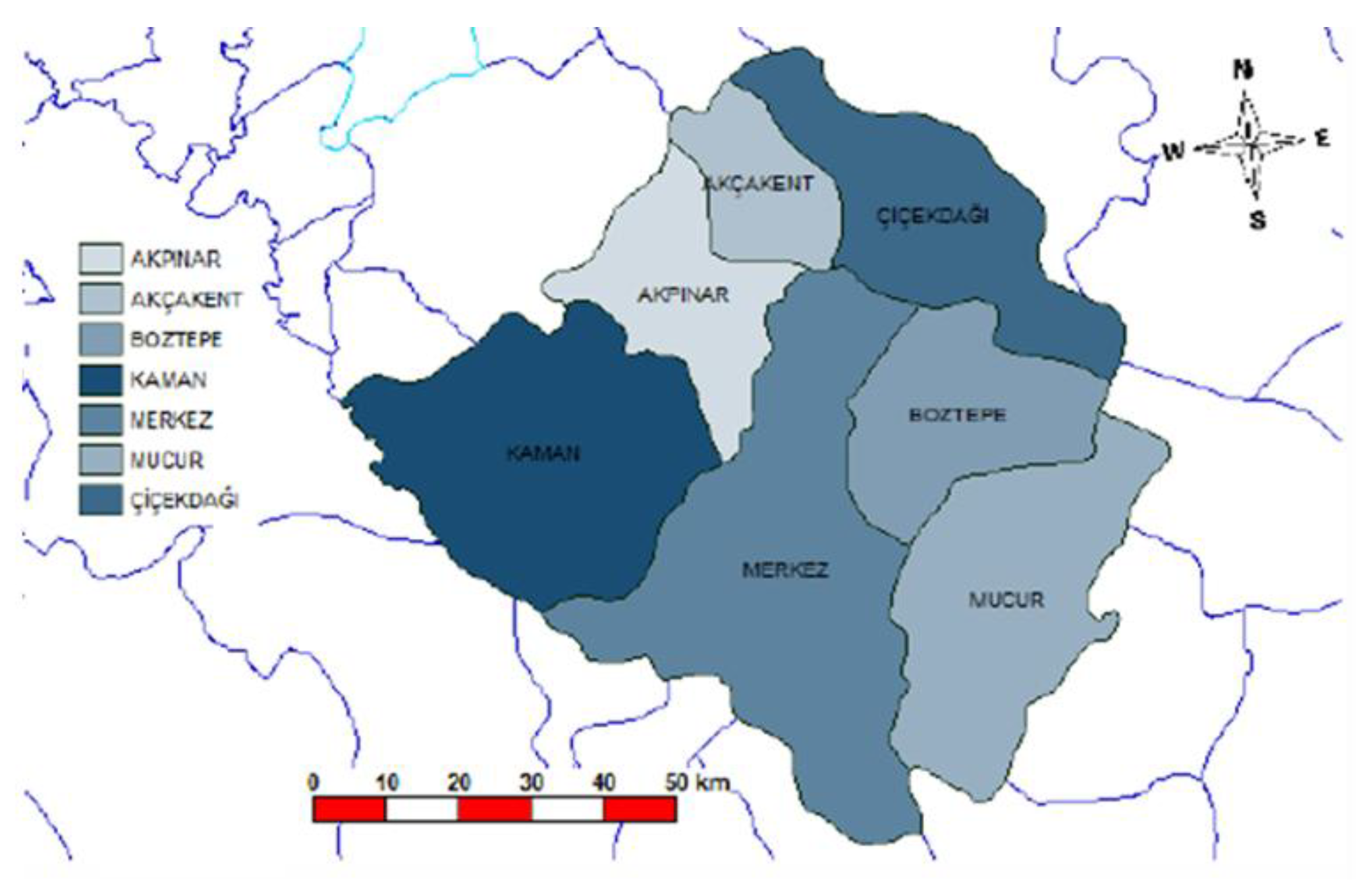
Figure 2.
Cadastral Parcel Layouts in Karaduraklı Village, Kırşehir Province, Before and After Land Consolidation.
Figure 2.
Cadastral Parcel Layouts in Karaduraklı Village, Kırşehir Province, Before and After Land Consolidation.
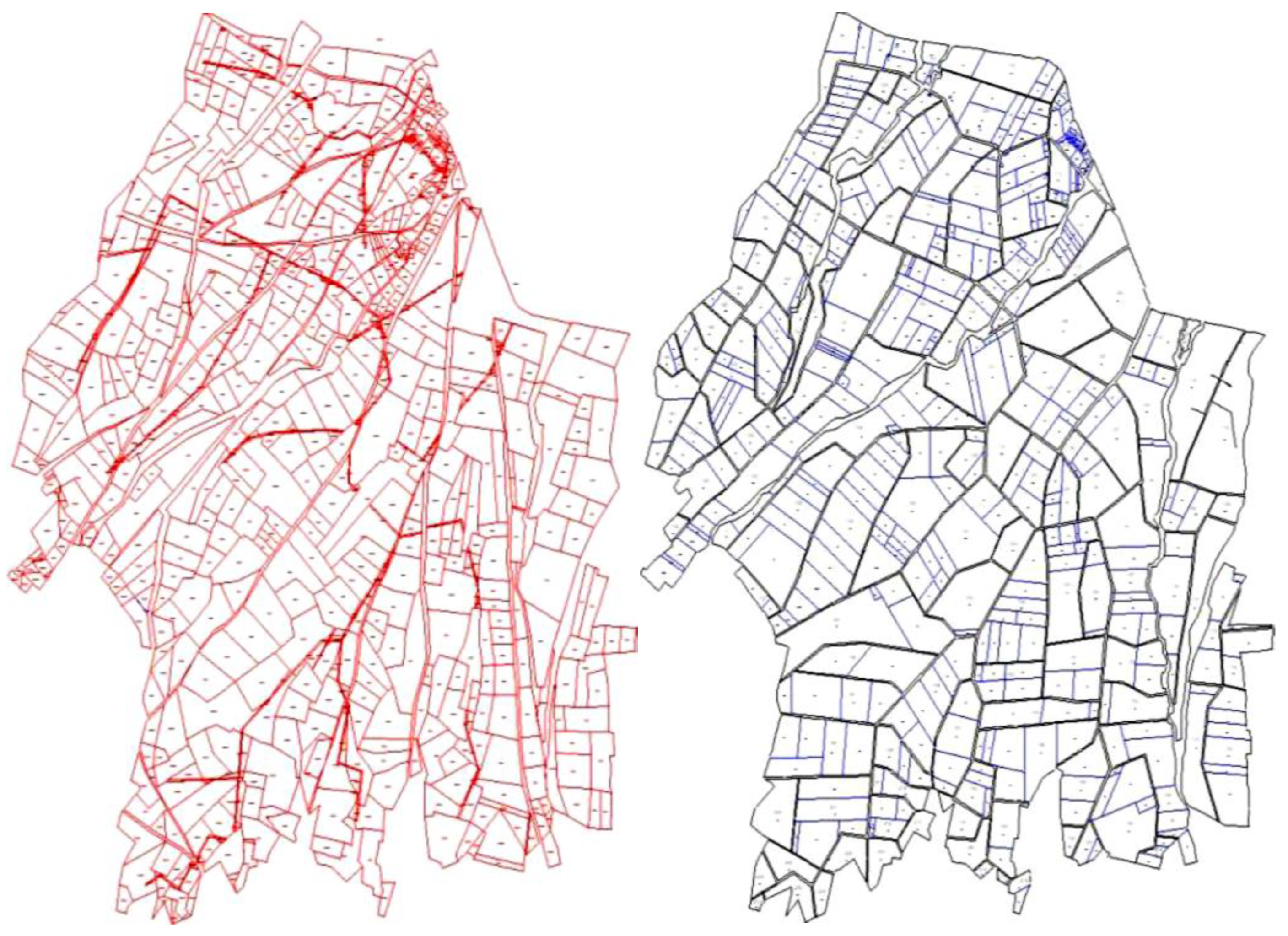
Figure 3.
Cadastral Parcel Layouts in Yeşilli Village, Kırşehir Province, Before and After Land Consolidation.
Figure 3.
Cadastral Parcel Layouts in Yeşilli Village, Kırşehir Province, Before and After Land Consolidation.
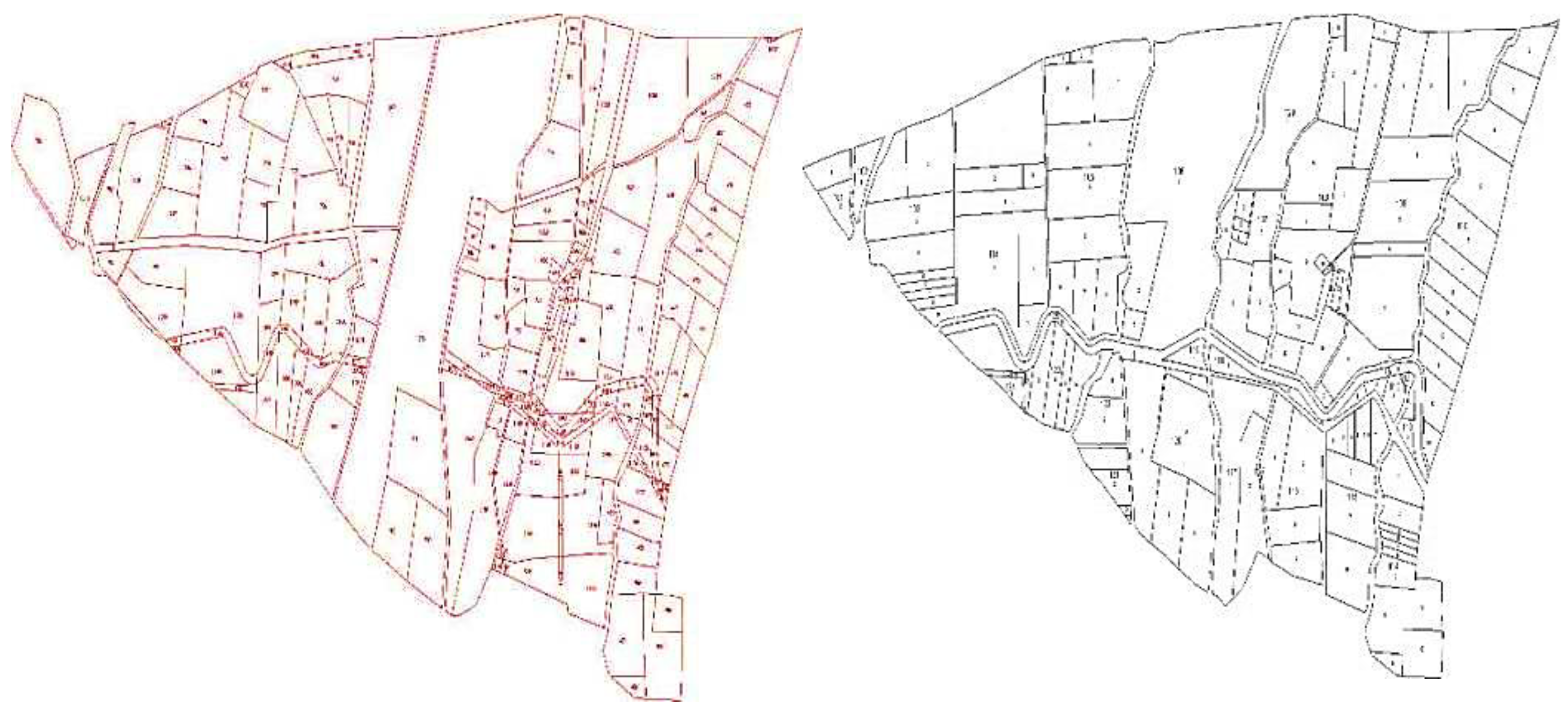
Figure 4.
Cadastral Parcel Layouts in Büyükkoba Village, Kırşehir Province, Before and After Land Consolidation.
Figure 4.
Cadastral Parcel Layouts in Büyükkoba Village, Kırşehir Province, Before and After Land Consolidation.
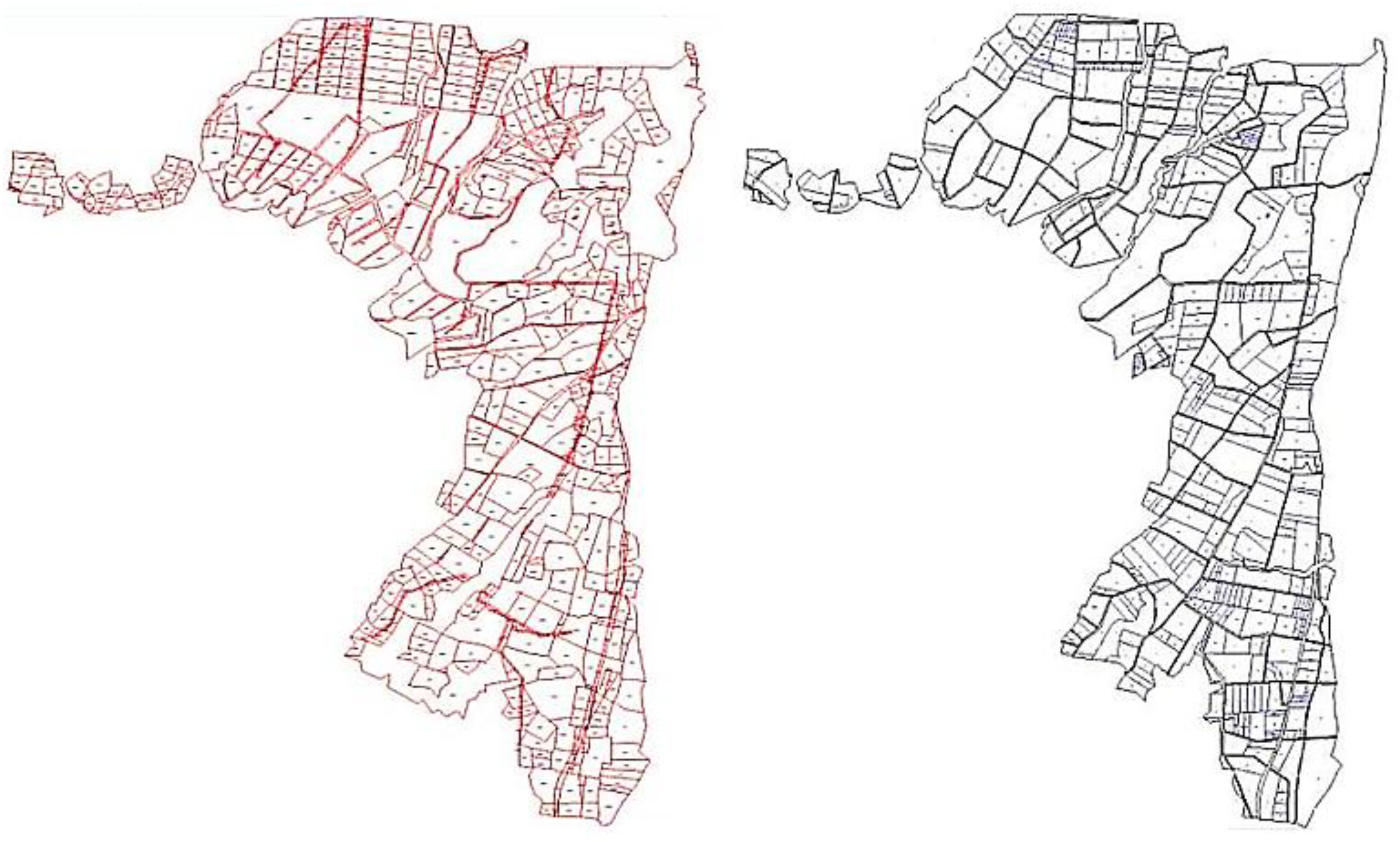
Table 1.
Tractor Density and Agricultural Area per Tractor in Kırşehir (2010–2022).
| Year | Number of Tractors | Cultivable Area (1000 ha) |
Tractors/ 1000 ha | ha/tractor |
|---|---|---|---|---|
| 2010 | 8,066 | 397.71 | 20.28 | 49.30 |
| 2011 | 10,080 | 413.49 | 24.37 | 41.02 |
| 2012 | 8,062 | 399.68 | 20.17 | 49.57 |
| 2013 | 7,381 | 384.53 | 19.19 | 52.09 |
| 2014 | 7,461 | 366.29 | 20.37 | 49.09 |
| 2015 | 7,500 | 391.66 | 19.15 | 52.22 |
| 2016 | 7,837 | 397.52 | 19.71 | 50.72 |
| 2017 | 7,866 | 352.58 | 22.31 | 44.82 |
| 2018 | 7,915 | 350.10 | 22.61 | 44.23 |
| 2019 | 7,972 | 325.00 | 24.53 | 40.76 |
| 2020 | 11,728 | 327.60 | 35.80 | 27.93 |
| 2021 | 10,994 | 326.50 | 33.67 | 29,70 |
| 2022 | 12,072 | 331.67 | 36.40 | 27.47 |
Table 2.
Number of Agricultural Implements per Tractor in Kırşehir (2010–2022).
| Year | Number of Implements | Number of Tractors | Implements per Tractor |
|---|---|---|---|
| 2010 | 41,425 | 8,066 | 5 |
| 2011 | 42,471 | 10,080 | 4 |
| 2012 | 42,681 | 8,062 | 5 |
| 2013 | 44,032 | 7,381 | 6 |
| 2014 | 44,209 | 7,461 | 6 |
| 2015 | 44,678 | 7,500 | 6 |
| 2016 | 45,798 | 7,837 | 6 |
| 2017 | 46,398 | 7,866 | 6 |
| 2018 | 46,507 | 7,915 | 6 |
| 2019 | 46,695 | 7,972 | 6 |
| 2020 | 47,257 | 11,728 | 4 |
| 2021 | 48,626 | 10,994 | 4 |
| 2022 | 49,596 | 12,072 | 4 |
Table 3.
Tractor Power per Cultivated Area (kW/ha) in Kırşehir Province from 2010 to 2022.
| Year | 2010 | 2011 | 2012 | 2013 | 2014 | 2015 | 2016 | 2017 | 2018 | 2019 | 2020 | 2021 | 2022 |
|---|---|---|---|---|---|---|---|---|---|---|---|---|---|
| kW/ha | 0.09 | 0.07 | 0.09 | 0.12 | 0.13 | 0.12 | 0.12 | 0.14 | 0.14 | 0.15 | 0.16 | 0.16 | 0.16 |
Table 4.
Number of Implements per Tractor in Kırşehir Province from 2010 to 2022.
| Year | 2010 | 2011 | 2012 | 2013 | 2014 | 2015 | 2016 | 2017 | 2018 | 2019 | 2020 | 2021 | 2022 |
|---|---|---|---|---|---|---|---|---|---|---|---|---|---|
| implements per tractor | 5 | 4 | 5 | 6 | 6 | 6 | 6 | 6 | 6 | 6 | 4 | 4 | 4 |
Table 5.
Cultivated Area per Tractor in Kırşehir Province from 2010 to 2022.
| Year | 2010 | 2011 | 2012 | 2013 | 2014 | 2015 | 2016 | 2017 | 2018 | 2019 | 2020 | 2021 | 2022 |
|---|---|---|---|---|---|---|---|---|---|---|---|---|---|
| ha/ tractor | 20.28 | 24.37 | 20.17 | 19.19 | 20.37 | 19.15 | 19.71 | 22.31 | 22.61 | 24.53 | 35.8 | 33.67 | 36.4 |
Disclaimer/Publisher’s Note: The statements, opinions and data contained in all publications are solely those of the individual author(s) and contributor(s) and not of MDPI and/or the editor(s). MDPI and/or the editor(s) disclaim responsibility for any injury to people or property resulting from any ideas, methods, instructions or products referred to in the content. |
© 2025 by the authors. Licensee MDPI, Basel, Switzerland. This article is an open access article distributed under the terms and conditions of the Creative Commons Attribution (CC BY) license (http://creativecommons.org/licenses/by/4.0/).
Copyright: This open access article is published under a Creative Commons CC BY 4.0 license, which permit the free download, distribution, and reuse, provided that the author and preprint are cited in any reuse.


