

Submitted:
05 December 2023
Posted:
06 December 2023
You are already at the latest version
Abstract
Public funding of land consolidation projects is an instrument of the Common Agricultural Policy of the European Union (CAP). The execution of systematic land consolidation programmes focused on optimising the spatial structure of agricultural areas presents a possibility to improve agricultural production conditions and maximise the efficiency of agriculture on a local, regional, national and international level. However, due to limited access to financial resources, it is necessary to delimit the priority areas for land consolidation. A contemporary practice based on the assessment of the social support percentage of potential land consolidation projects in individual villages does not represent a real necessity for action. This problem leads to ineffective utilisation of financial resources and reduces the efficiency of the implemented programmes. We proposed a new algorithm for assessing real needs for land consolidation based on a detailed multi-faceted analysis of the spatial structure of agricultural areas. The research method involved factors describing the spatial structure defectiveness of farms as well as those determining land quality in correspondence to investment’s profitability. Another factor verifying the potential economic rationale of land consolidation was transaction prices mostly reflecting the agricultural value of the land. The analysis showed that land consolidation in areas with defective spatial structure and a relatively high market value should be a priority. This approach will contribute to maximising profits by increasing the productivity of areas featuring the highest agricultural suitability.
Keywords:
land valuation
; land spatial structure
; land consolidation
; sustainable development of rural areas
; GIS
1. Introduction
Land consolidation, financed by public funds, are a key instrument of national and regional agricultural policy in the context of sustainable development of rural areas understood as centres of agricultural production and living space [1,2,3,4,5,6,7,8,9]. In Poland, the rural population accounts for 40% of the total population, while 8.4% of the working population are employed in the agricultural sector [10]. Due to the occurrence of unfavourable spatial structures of agricultural farms, observed in particular in the southern, eastern and central parts of the country [11], the need to optimise the layout of agricultural production space is reflected in the actual activities of the public administration, carried out within the framework of cyclical programmes and strategic plans being part of the European Union’s Common Agricultural Policy. Financing of land consolidation works by public funds translates into widespread availability of instruments to optimise the spatial structures of rural areas. However, the scale of the observed needs in terms of the correction of defective land layouts involves the need to select areas intended to be included in a land consolidation procedure.
The previous practice of selecting potential objects to be covered by public funding in Poland, adopted for the Rural Development Programme for the years 2014-2020, took into account generalised criteria, such as:
- percentage of the number of land owners who have submitted applications for carrying out a land consolidation procedure in the total number of farm owners, or percentage of the area of farms whose owners have submitted the aforementioned applications in the total area of farms
- positive impact of the operation on the environment
- improvement of landscape values
- allocation of land for local public utility purposes
- allocation of land for the purposes of improving hydrographic conditions in terms of water retention [12].
The above assumptions were based solely on public support for the initiative, and the quality of the proposed solutions. As a result, it was possible to carry out land consolidations in areas with a favourable spatial structure of land, including the so-called secondary land consolidations carried out on objects consolidated in the recent past, for which the motivation was the possibility of obtaining funds for the modernisation of the village infrastructure as part of the so-called post-consolidation management.
With the accession of the Strategic Plan of the Common Agricultural Policy for the years 2023-2027, the operation selection criteria were based on modified criteria taking into account the following:
- percentage of the number of land owners who have submitted applications for carrying out a land consolidation procedure in the total number of farm owners, or percentage of the area of farms whose owners have submitted the above-mentioned applications in the total area of farms,
- the area of the designed land consolidation area,
- average number of cadastral plots per agricultural farm,
- average cadastral plot area in the designed land consolidation area,
- the actual allocation of land in the project for the local public utility purposes,
- the actual taking into account of investments that optimise water retention,
- planned environmental protection solutions (preservation of turf-covered slopes, provision of woodlots and shrubs, and delimitation of buffer zones and the field-forest boundary),
- the actual taking into account of the division of common land or the disposition of land included in the Agricultural Property Stock of the State Treasury [13].
Detailed expansion of the criteria for selecting objects to be consolidated, and the inclusion of selected parameters concerning the condition of the spatial structure are changes aimed at ensuring the substantive validity of carrying out land consolidation procedures, and ensuring the availability of intervention instruments for areas with the greatest needs.
The approach assuming the selection of potential objects to be consolidated, based on the assessment of the actual condition of the spatial structure and the delimitation of areas with the most urgent needs, is supported in numerous titles of the world scientific literature. Research on the methodology for assessing and hierarchising land consolidation needs has been conducted e.g. in China [14,15,16], Croatia [17], Cyprus [18], Turkey [19], Poland [11,20,21,22,23,24,25], Serbia [26], Finland [27], Estonia [28], Lithuania [29], Ukraine [30] and Slovakia [31,32,33].
Tomić et al. use cadastral data to carry put a generalised hierarchisation of land consolidation needs at the national scale for Croatia. The proposed analytical method considers factors such as the proportion of agricultural land in the total area of a particular administrative unit, average cadastral plot size, regularity of plot shapes, the level of land fragmentation, proportion of land owned by the state, the level of regional development, and the number of agricultural farms. The authors subject the values of individual indices to standardisation by the unitisation with zero minimum method, and then calculate the synthetic index value using different statistical methods, such as the Weighted Sum Model (WSM), PROMETHEE, and TOPSIS [17].
Muchová and Petrovič describe an original authors’ method for examining the prioritisation of land consolidation works, applied in the Žitava River basin in Slovakia. The authors include separated areas (clusters) in the study, and analyse parameters such as the total area of land, the area of arable land, the area of permanent crops, the area of forests, the number of plots being part of common land, the average number of plot co-owners, the number of undetermined landowners, population of a particular cadastral unit, population of settlements with an unregulated legal status, the degree of water erosion, and the geomorphological criteria [31]. The validity of considering the factors related to the problematic ownership of land stems from historical determinants, including the collectivisation of agriculture in the former socialist Czechoslovakia [34].
The issue of ranking the land consolidation needs is also addressed in analyses undertaken by Polish researchers. Janus and Taszakowski use of a set of original authors’ indices that describe the size structure of farms, land fragmentation, soil quality, accessibility of roads, and the results of the analysis of photogrammetric studies in terms of field difficulties in potential land consolidation works. Therefore, the synthetic index, in addition to the factors determining the demand for the performance of land consolidation works, also considers the actual technical capacity to perform the works [20].
The topic of the hierarchisation of land consolidation needs in the programming of management and agricultural works is also addressed by Stręk and Noga. The authors carry out a statistical analysis of 41 indices that characterise the land ownership and use structure, the productive value of individual usable agricultural land plots, the level of land fragmentation, the distribution of non-resident owners’ ownership, the plot shape, and the accessibility of roads. Based on the obtained results, the authors divide the localities under study into groups varying in terms of the prioritisation of land consolidation works [35].
The numerous concepts of the hierarchisation of demand for land consolidation works and delimitation of potential objects to be consolidated, observed during the analysis of world literature on the subject, include in particular the issues concerning the spatial and ownership structure of land, and its agricultural suitability. The subject of this study is the experimental selection of localities intended to be included in a land consolidation procedure, using cadastral databases and information on property transaction prices. The authors implemented their own, new algorithm, designed for selection of the studied objects and an original, dedicated method of calculating the land consolidation priority indicator. The analysis also used previously used factors describing the condition of agricultural farms’ spatial structure and the land productive value. The study conducted a multi-aspect analysis of the prioritisation of land consolidation works for the areas under analysis, and compared the information from the study of individual factors.
2. Materials and methods
A detailed study was conducted for the area of Kolbuszowski County located in Podkarpackie Voivodeship, in south-eastern Poland. The study area covers an area of approx. 773.16 km2, of which approx. 30.5% comprise arable land, while approx. 25.5% are covered by grassland (measures and pastures). The location of the study area is shown in Figure 1.
For the purposes of the study, spatial data from two distinct thematic categories were acquired. Detailed characteristics of the input data used are provided in Table 1.
As can be seen from the data provided in Table 1, the first of the downloaded information resources is the Land and Property Register database. The data were sources from the County Starosty in Kolbuszowa in the form of a database file including comprehensive, standardise cadastral data comprising a graphical and descriptive part. A set with a structure determined by current legal norms [36] enables obtaining e.g. information on the shape and location of plots, land valuation classification, and the use of land. The database also contains comprehensive information on land ownership, relevant for the analyses carried out in the thematic area of land consolidation works.
The second category of the acquired data is a set of files representing the property price register made available also by the County Starosty in Kolbuszowa. The information includes a comprehensive and detailed documentation of historical transaction from the years 2011-2023, concerning undeveloped agricultural land from the area of Kolbuszowski County. This register, which is maintained on the basis of nationwide standards [36], is in the form that allows a link to the Land and Property Register database to be established.
Due to the specific nature of the processed data and the subject matter of the study, the activities carried out were based on spatial analyses performed by GIS methods, supplemented with elements of statistical analysis and the methodology for updating transaction prices, used e.g. for the purposes of land valuation [37].
In order to implement an effective analytical procedure, a preliminary analysis of the structure of the acquired input data was carried out, and then a framework work plan was defined, including the adaptation of source information, the development of original authors’ research tools, and the calculation and interpretation of the resulting data. The adopted action strategy in schematic terms is provided in Figure 2.
Given that two separate sources of spatial data on properties were used, the processing of information was carried out in a two-pronged manner. The first part of the data processing procedure included activities related to the objects of the Land and Property Register database (1-5). The second part of the work concerned the content of the property price register (6-8). At the final stage of the procedure, the data were integrated in order to perform analyses concerning the main research problem.
Firstly, the objects of the Land and Property Register database were converted to a form enabling the performance of spatial analyses in the GIS environment. The widespread use of the data exchange standard which assumes the use of GML format [38] enabled the efficient entering of the input data and the initialisation of analysis sequences. In view of the specific subject matter of the study, concerning land consolidation, the analysed set of cadastral plots was limited only to agricultural plots selected based on the information on land use, available in the database.
2.1. Plot shape analysis
The first analysis of the land spatial structure, carried out using cadastral data, was a complex, multi-aspect analysis of the plot shape. For the purposes of the study, a method proposed by Demetriou was used, which assumes the calculation of an integrated Parcel Shape Index (PSI) based on the following factors:
- number of edges shorter than 20 m,
- number of acute angles,
- number of concave angles,
- number of vertices (boundary points),
- compactness,
- regularity [39].
The applied method enabled the calculation of a synthetic index that determines agricultural suitability of plots in terms of the shape of their contours. The concept is based on the assumption that an optimal agricultural plot should have a regular shape similar to a rectangle. Irregular and fragmented contours of plots are assessed to be unfavourable due to potential difficulties in the performance of agricultural operations [40].
The analysis yielded as set of spatial data representing the plots under study, supplemented with the value of the calculated PSI index which takes a value in the form of a floating point number from the range of 0 to 1. For the purposes of further research, the nominal PSI value was replaced with CPSI index calculated as follows:
A spatial representation of the study results in cartographic terms is shown in Figure 3.
The obtained results show a significant predominance of areas covered by plots with highly unfavourable shapes, including the excessive elongation, characterised by the so-called ribbon pattern of land. Approximately 78% of the studied area is covered by the parcels with a CPSI index of 0.50 or more and about 26% of the county consists of the parcels with an index of 0.90 or more. The arithmetic average value of the calculated CPSI index for the plots under study was 0.56, while the plot area-weighted average was 0.71. The high index values indicate the validity of carrying out the correction of plot shapes, which is one of the basic tasks of the land consolidation procedure, whose main task is to improve farming conditions in rural areas [23] which cover approx. 93% of the total area of Poland (the status current as of 2020) [41].
2.2. Analysis of plot access to public roads
Many years of research have shown that rural areas in southern, south-eastern, eastern and central Poland are characterised by a very high percentage of plots without direct access to a public road. Therefore, when assessing the defectiveness of rural areas’ spatial structure, it is necessary to determine the number and percentage of plots without access to a road, as it is standard practice during the implementation of land consolidation works in Poland to ensure access to a public road for each of the designed plots.
In order to efficiently delimit plots without direct access to a public road, a spatial analysis was conducted using land use data. A binary-type variable CATR, for which the value of “0” for a particular plot indicates observed access to a road, while the value of “1” indicates no access to a road, was adopted as the study result. A spatial representation of the processed analysis is shown in Figure 4.
The study reveals that 40649 cadastral plots have no direct access to a public road, which accounts for 41.2% of the total number of plots in the study area and 30.0% of the area of the studied lands. The lack of direct access to a road results in restrictions on farm management, which may translate into additional costs associated with the establishment of easement, a decrease in the productive value of the burdened plot, and potential conflicts between landowners. The significant proportion of plots without access to a road in the total number of plots is a factor that indicates the validity of correcting the defective spatial structure in the land consolidation process [42].
2.3. Land dispersion analysis
Land dispersion, also defined as one of the manifestations of the internal farm fragmentation [43], occurs where farm plots are distributed over an extensive area [44]. A negative consequence of land dispersion is the higher cost of carrying out agricultural activity, resulting from the increased cost of transport between plots and the increased time-consuming nature of performing agricultural works [45].
The methodology for assessing land dispersal can vary depending on the purpose of the analysis, the type of available data, and the specific nature of the area under study. The practice of assessing the spatial structure of rural areas, carried out at the preparatory stage of a land consolidation procedure, is usually based on an analysis of distance between agricultural land of farms and their farmstead centres [25,46].
The research used a land dispersion index calculated as an average distance between the farm’s agricultural plot centroids and the centroid of its farmstead centre understood as a plot with buildings necessary for carrying out agricultural activities (the so-called farm buildings). The affiliation of plots to individual farms was determined on the basis of the relevant relationship in the cadastral database. The target land dispersion index CDSP, calculated for each identified farm based on the following formula, was determined empirically based on the distribution of values calculated in the course of this analysis.
where:
CDSP – land dispersion index
D – average distance between a plot and the farmstead centre
The results obtained for all farms under study are provided in Figure 5.
The average distance between an agricultural plot and the farmstead centre for all agricultural farms in Kolbuszowski County was 599.32 m. The presence of areas with a significantly higher land dispersion index can provide initial information on the possible location of land requiring the performance of land consolidation works [45].
2.4. Land fragmentation analysis
The term “land fragmentation” is defined in a variety of ways in the world literature. Van Dijk distinguishes four types of fragmentation depending on the origins of the phenomenon [43]. The study area is characterised by the internal fragmentation of farms, typical of south-eastern Poland and manifested by the division of a farm into a large number of plots that are often isolated from each other.
In order to assess the degree of land fragmentation, an analysis of cadastral plots being part of the farms under study was carried out. As a result of the analysis, CFRG index with values determined based on the following empirical formula, was calculated for each farm:
where:
CFRG – land fragmentation index
n – number of cadastral plots being part of a particular farm
A spatial representation of the performed calculations is shown in Figure 6.
According to the study, an average farm comprises approximately 3 cadastral plots. The average area of a cadastral plot is approximately 0.44 ha. However, the occurrence of areas with a significantly higher farms’ land fragmentation, located in particular in the north-eastern part of the county, was noted.
2.5. Calculation of the synthetic land consolidation need index
The values of the calculated indices CPSI, CATR, CDSP and CFRG were averaged to obtain a synthetic C, index indicating the urgency of performance of land consolidation works for a particular area. Due to the varying and ambiguously defined spatial resolution of each of the partial measures, a logical sum of spatial sets was used in the calculations. The calculated C index was subjected to cartographic visualisation, and its spatial representation is shown in Figure 7.
Particularly high demand for land consolidation works, manifested by clearly unfavourable (high) values of individual land spatial structure indices and an elevated value of the synthetic C index, is observed in the eastern part of the county. In this area, the land is characterised by e.g. highly unfavourable (irregular and excessively elongated) shapes of plots, and considerable land fragmentation within farms, including significant distances between agricultural plots and farmstead centres. The intensity of the factors that reduce the production values of farms indicates that the correction of the defective spatial structure of agricultural land through a consolidation procedure should be carried out as a matter of priority.
2.6. Preselection of transaction data
The data acquired from the property price register, which includes the complete range of transactions for undeveloped land, was subjected to expert verification and selection. Nearly 3800 data were obtained in the form of transaction prices for the years 2011-2023. Only agricultural land transaction (1408 records) were selected from these data. Due to the agricultural nature of the communes situated in this county, a considerable number of the properties being the object of trade are properties purchased for the purpose of farm extension. Only the land intended for agricultural production, according to the entries in area development plans, were used for the analysis. However, in the absence of the plan, it was land without building permit.
Therefore, the transactions qualified for the analysis were those concluded under free market conditions, assessed as a representative source of data on the prices of property used for agricultural production in the study area.
2.7. Update of transaction prices
Due to the considerable time span between the transactions under study, the recorded prices were updated to the date of carrying out the study, i.e. 10 July 2023. The procedure was carried out using a model of linear regression, defined by mean values and standard deviations, in marginal distributions determined on the basis of the results from the sample, and taking into account the (Pearson’s) complete correlation coefficient [37], using the following calculation formulas:
where:
– transaction price of the i-th property
– regression coefficient
– date of update (expressed in months)
– date of transaction (expressed in months)
– coefficient of correlation between the unit transaction price and the date
The correlation coefficient determines the direction and strength of the relationships between the analysed variables, which, in a particular case, will enable an assessment as to whether the set of prices needs to be updated. The strength of the correlation was considered at five levels: r < 0.2 – no correlation; 0.2 ≤ r < 0.4 - weak correlation, 0.4 ≤ r < 0.7 - moderate correlation, 0.7 ≤ r < 0.9 - strong correlation, and r ≥ 0.9 - very strong correlation.
Due to the spatial variation of the factors that determine property prices, the update was carried out separately for each of the communes being part of the county under study. The obtained correlation coefficient value confirmed the relationship between the date of the transaction and the transaction price. The obtained index value was higher than 0.2. For most communes, a correlation coefficient of more than 0.4 (moderate correlation) was obtained. In only two cases, the coefficient value falls into the second range (weak correlation).
After eliminating the “time” factor as an important element differentiating transaction prices, the updated prices were further analysed using GIS tools.
2.8. Delimitation of priority areas, and a ranking of villages according to the market value of land
The calculated, updated transaction prices of land were georeferenced based on information on cadastral plot identifiers. The created point layer was then interpolated by the Voronoi polygon method to obtain a map that preserves the spatial continuity of transaction price values for the entire study area.
The values of the unit transaction price attribute were classified by the equinumerous interval method, and the outlier records (exceeding the value of the average price increased or decreased by three times the deviation standard for the population) were excluded, yielding the P attribute taking values from the range (0;1). The rule for assigning the P attribute’s values to the polygons representing the spatial distribution of the transaction prices of land is provided in Table 2.
Cartographic visualisation of the Voronoi polygons representing unit transaction prices of land, converted into the P index form, is shown in Figure 8.
Particularly high transaction prices of land, exceeding a value of PLN 100.000 per ha, are observed in the area of the town of Kolbuszowa and in its immediate vicinity. High transaction prices were also observed in the south-western part of the county. Relatively low prices were noted in the eastern part of the district under study. A detailed interpretation of the graphically presented distribution of land transaction prices in the context of demand for land consolidation works is provided in Section 3.
2.9. Analysis of arable land’s productive value
In view of the need to provide details of the conclusions formulated on the basis of the analysis of the spatial distribution of property transaction prices, and the demand for land consolidation works, the study also covered the productive value of agricultural areas. This parameter is both a factor that potentially determines land prices and a criterion for the validity of carrying out a land consolidation procedure.
For the purposes of the study, a method proposed by Leń was employed, which enables the efficient identification of the productive value of agricultural land (arable land and grassland) based on pedological land classification data available in the cadastral database maintained at the county level [47]. Pre-defined scores of the individual land classes, used e.g. for the purposes of land value estimation carried out as part of the land consolidation procedure, was applied as a measure of the land productive value [48]. In order to enable a comparison of the obtained results with the results of other analyses, the scores were subjected to unitisation with zero minimum, performed according to the following formula:
where:
– value of the variable after unitisation for the i-the element of the set (agricultural land suitability index)
– original value of the variable for the i-th element of the set
– minimum variable value in the set
– maximum variable value in the set
[11[]
The adopted method for calculating Q index values for individual land classes is provided in Table 3.
A spatial representation of the value of Q index calculated for the land of the study area is provided in Figure 9.
As a result of the preliminary analysis of the spatial distribution of the value of the Q index that represents the productive value of agricultural land, it is concluded that land with low and very low suitability for agriculture is found almost throughout the entire study area.
2.10. Data synthesis
As a result of carrying out the activities described in detail in Sections 2.1 - 2.9, extensive data were obtained on the multifactorial specificity of land consolidation needs, the characteristics of the distribution of transaction prices of agricultural land, and the agricultural land suitability for the study area of Kolbuszowski County. The information obtained in the form of a set of georeferenced indices was characterised by varying spatial resolution and non-uniform spatial coverage. In order to enable the integration of the developed geographical information and its correct interpretation, the data was subjected to spatial generalisation, assuming the area of a cadastral district (a single village or town) to be the basis spatial unit of the study area. Out of the Kolbuszowski County under analysis, 52 cadastral districts were separated, for which substitute indices, based on the averaged values of C, P and Q indices, and weighted by the areas of the existing elementary polygons, were calculated. The result of this analysis, which achieves one of the main research objectives of this article, is provided in Section 3.
3. Results
The completed research procedure, described in Section 2, yielded detailed output data providing information necessary for the assessment of the villages under study in terms of the agricultural areas’ spatial structure, the demand for land consolidation works, and the distribution of transaction prices of undeveloped land property intended for agricultural use. In the course of the integration of the results of multi-stage analytical work, two basic summaries of indices calculated for cadastral districts (villages or towns) of Kolbuszowski County were obtained. A map of the assessment of land consolidation work prioritisation (C index) is provided in Figure 10. A map of interpolated, averaged transaction prices (P index) constitutes the content of Figure 11. An index of cadastral district designations, and a comparison of the values of both indices area provided in Table 4.
The highest values of the land consolidation work demand index (C) were noted in the eastern part of the county (in particular in the localities of Wola Raniżowska and Lipnica with the C index values of 0.73 and 0.72, respectively). At the same time, this area is characterised by the lowest unit transaction prices of agricultural land. A minimum P index value of 0.29 was noted for the village of Zielonka. On the other hand, relatively high prices of land were observed in the north-western part of the county, which is characterised by a favourable spatial structure of agricultural areas. A generalised statistical analysis of the calculated values of the C and P variables is provided in Table 5 below.
The land consolidation work demand index (C) takes values from the range of 0.40 - 0.73. The average value is 0.76, while the standard deviation reaches a value of 0.07. As for the land unit transaction price index (P), values ranging from 0.29 to 0.97 were obtained. The average index value is 0.54 with a standard deviation of 0.16. The calculated coefficient of correlation between two variables, equal to -0.35, indicates an average negative correlation [37].
Based on the calculated values of the indices describing the characteristics under study, the analysed cadastral districts were divided into four groups. The classification was developed in accordance with the rule as described in Table 6.
The distribution of the values of C and P indices for the cadastral districts under study, taking into account the developed classification, was also visualised in the form of a diagram in Figure 12.
The spatial representation of the completed classification of the analysed cadastral districts in the cartographic form is provided in Figure 13.
The “A”-type localities, characterised by low demand for land consolidation works and high prices of land, are located only in the north-western part of the county (12 localities) and in the immediate vicinity of the town of Kolbuszowa (5 localities) which is the seat of the county under analysis. As for the areas located near the town, it is reasonable to assume that the main determinant of land prices is the favourable location. In other cases, high prices of land coincide with the satisfactory quality of the spatial structure of agricultural areas, which translates into the lack of noticeable need for the performance of land consolidation works.
The “B”-type localities make up the least numerous group. Of the five classified cadastral districts, one is located in the northern part of the county, one in the western part, one in the south-eastern part, and two in the central part of the county. The group includes localities with high land transaction prices and high needs for land consolidation. A detailed determination of the reasons behind the phenomenon requires additional analysis of the agricultural stability of land in terms of geomorphological and soil conditions. With the assumption of high productive values of the land of this group, carrying out the land consolidation procedure in this case should be considered particularly reasonable from an economic point of view.
The “C” group includes 13 localities with low needs for land consolidation and low transaction prices. 10 localities assigned in this group are located in the south-western part of the county, two are located in the central part, and one in the eastern part. Despite the relatively favourable spatial structure of farms, arable land in the localities in this category do not achieve high selling prices. This phenomenon may be due to the low productive qualities of the soil as well as other factors limiting the development of agriculture, which cannot be corrected in the course of the land consolidation procedure.
The “D” group, which comprises 17 localities, includes cadastral districts with high demand for land consolidation works, and low transaction prices of land. The localities classified in this group are mostly located in the eastern and central part of the county, with only two localities located in the western part. The group includes e.g. six consecutive cadastral districts placed in the highest positions of the ranking of demand for land consolidation works. A defective spatial structure, including the excessive elongation and irregular plot shape as well as land fragmentation and dispersion, which hinders agricultural activity, may lead to a reduction in property values. The unfavourable phenomenon can be eliminated or limited through a land consolidation procedure leading to the optimisation of the usable value of agricultural land by means of correcting the spatial structure of farms. However, particularly low transaction prices of agricultural property may indicate geomorphologically- or sozologically-based limitation of agricultural productivity. Therefore, the areas assigned to “D” group should be subjected to a particularly thorough analysis of agricultural suitability of land, and to the delimitation of the so-called ‘problem areas’ of agriculture, which are potentially to be excluded from agricultural production, and used for alternative purposes [23].
Dur to the observed ambiguity of information derived from the analysis of agricultural land’s spatial structure and the property transaction prices, it is necessary to carry out an additional analysis of agricultural land suitability. It was assumed that a detailed study on the quality of land intended for agricultural purposes could provide important information on the reasons behind the variation of land prices, and contribute to the correct delimitation of potential objects to be consolidated. The previously developed classification of cadastral districts under study, based on the values of the C and P indices, was supplemented with another spatial data layer representing the usable (productive) value of land via the Q index calculated on the basis on the pedological classification of land. A generalised statistical summary of Q index aggregated for cadastral districts is provided in Table 7.
The aggregated Q index takes values from 0.09 to 0.34, with an arithmetic mean of 0.20, and a standard deviation of 0.06. The obtained results confirm the preliminary thesis that the land in the area of the county under study has a relatively low productive value. The average index value corresponds roughly to class V (poor soils) [49] for both arable land and grassland.
r-Pearson’s correlation coefficients were also calculated for the developed Q index in relation to variables C and P, shown in Table 8.
A weak positive correlation (correlation coefficient of 0.23) was noted between the variables C and Q. On the other hand, no unequivocal correlation was observed between the variables P and Q (r-Pearson’s coefficient of -0.10).
Spatial visualisation of the developed classification of localities, along with the aggregated Q index values, make up the content of Figure 14.
A primarily visual analysis of the above summary reveals no clear relationship between the production value of agricultural land and land prices or land consolidation needs. In order to analyse the obtained results in detail, the Q index values were aggregated according to the selected groups of localities. The aggregation was carried out using an average weighted by the area of the cadastral districts included in each group. The calculated values of the aggregated Q index for individual groups are provided in Table 9.
In view of the specific nature of the subject matter of the ongoing research, particular attention was paid to the analysis of the localities assigned to groups “B” and “D”, which include cadastral districts with above-average demand for land consolidation works.
As can be seen from the obtained numerical data, the lowest agricultural land suitability index value of 0.14 was noted for group “B”. Although the specific nature of the spatial structure of the localities of this group indicates the validity of correcting the defective layout of the farms, the low productive value of the land may be related to the lack of economic rationale for undertaking complex and costly management and agricultural operations. The presumed reason for the high property transaction prices for “B”-type localities, irrespective of the land functional quality, may include their low accessibility or the possibility for potential conversion of the purchased land for non-agricultural purposes.
In contrast to category “B” localities, the “D” group is characterised by the highest aggregated Q index value of 0.22. This group also includes two cadastral districts with the highest noted index values of, respectively: 0.34 for the locality of Kupno, and 0.32 for the locality of Werynia. High demand for land consolidation works, and the relatively high agricultural land suitability indicate the potential economic efficiency of carrying out management and agricultural works. The optimisation of fragmented and dispersed agricultural farms distributed in the so-called ribbon pattern can also contribute to an increase in the value of agricultural land, which currently remains at a relatively low level.
4. Discussion
The study yielded a detailed, multi-aspect description of the county under study in terms of both the factors that characterise the spatial structure of agricultural land, and the distribution of property transaction prices. The use of standardised cadastral data enabled the performance of a number of spatial and statistical analyses, leading to important conclusions as regard the relationships between the overall condition of the spatial structure of farms and their potential value as projected based on historical transactions. The demonstrated correlation between the land consolidation work demand index and the transaction prices of agricultural property does not represent a strong linear relationship. However, it may indicate the validity of optimising the spatial structure of land in order to increase its value [50]. This hypothesis was confirmed by another analysis that considered the assessment of land productive value as determined by pedological classification. The indices of soil quality (productive value) are used, as a significant determinant for the selection of potential objects to be consolidated, by a considerable number of researchers, including Leń [23], Janus & Taszakowski [20], and Uyan [51]. The original authors’ detailed indices describing soil quality include such factors as e.g. physico-chemical and granulometric parameters as well as susceptibility to erosion. The pedological classification used in this analysis is a result of an expert assessment of land, recorded in a standardised cadastral database. The use of predefined patterns for assessing the quality of soils limits the detail of assessment to some extent. However, an important benefit of adopting this methodology is that it significantly streamlines the research procedure, and ensures the universality of the methodology proposed. Another potential limitation of the method may be non-standard, difficult to detect factors modifying the transaction prices in a way different from the general trends, determining the assumptions of the research. The proposed solution, probable to be developed on the future research stages, may be the extension of the adopted scheme by a detailed statistical analysis of the relations between the transaction price and its determinants.
The proposed division of the localities under study into groups distinguished on the basis of an assessment of the spatial structure of farms, which determines the degree of demand for land consolidation works, and an analysis of the distribution of property transaction prices, which provides the basis for determining land value, enabled a preliminary delimitation of areas requiring the performance of management and agricultural operations as well as the determination of the trends in their implementation. An analogous approach was noted in selected referenced titles. Methods that assume the grouping of localities with similar characteristics are proposed e.g. by Stręk and Noga. The authors emphasise that combining potential objects to be consolidated into groups enables e.g. the proper selection of operational methods in the case of the inclusion of an area covering more than one cadastral unit in the land consolidation procedure [35].
The consideration of the actual land transaction prices, which reflect the action of the factors that determine their value, is an important addition to the information on the validity of commencing land consolidation works in terms of their profitability from the perspective of both land owners and public administration bodies that carry out agricultural policy at the regional and national level. The acquired information on market values of land can also be used in the course of land consolidation procedure, at the stage of estimating the land of individual farms in order to correctly separate equivalent land [52,53,54,55,56,57,58,59,60,61,62].
5. Conclusions
The complex nature of management and agricultural works necessitates the use of concepts and tools that ensure high efficiency of the ongoing tasks aimed at the sustainable development of rural areas. The issue of planning and carrying out land consolidation works, which is one of the key issues of the national and regional agricultural policy, involves the need to ensure maximum efficiency of the works being carried out, which is manifested in economic and social benefits. The limited financial resources dedicated to management and agricultural works imply the need to develop an efficient action strategy based e.g. on the substantive pre-selection of potential objects to be consolidated.
The proposed solution, which includes a detailed analysis of the spatial structure of the village, supplemented with a study on the spatial distribution of land transaction prices, helped obtain preliminary information that characterises local agriculture in terms of the economic rationale for carrying out management and agricultural works. Taking into account the transaction prices of the real estate, which are a reliable reflection of the real market value basing e.g. on the agricultural production suitability, enabled to enhance the method of delimitation of a group of localities where the potential land consolidations is supposed to be the most profitable. From an extensive set of 52 villages, the areas characterized by an unfavourable spatial structure as well as high transaction prices related to the potential agricultural use value, were selected. The use of data derived from the county cadastral database with a structure and content in line with national standards proves the universality of the developed method, and the possibility of application of analogous schemes of procedure to study areas located in different regions of the country, and, provided that necessary technical modifications are made, in any countries and regions of the world where agricultural activity is carried out. The authors suggest continuing the research on the factors determining the land consolidation priority in order to eliminate the limitations of some of the data sources and maximise the reliability and versatility of the results obtained.
The multi-aspect strategy for the delimitation of agricultural land intended for priority optimisation of production conditions is a prerequisite for the effective implementation of agricultural policy aimed at ensuring food security and creating economic development at the regional, national and international levels. Taking measures to modernise agriculture in the context of sustainable development of the regional economy should therefore be considered a necessary instrument for implementing the conditions necessary to ensure a stable future for society.
Author Contributions
Conceptualisation, Michał Maciąg; methodology, Klaudia Maciąg; validation, Przemysław Leń; formal analysis, Monika Siejka; investigation, Jacek Rapiński; resources, Katarzyna Kocur-Bera; data curation Klaudia Maciąg; writing—original draft preparation, Michał Maciąg; writing—review & editing, Przemysław Leń; visualisation, Monika Siejka; supervision, Katarzyna Kocur-Bera; project administration, Jacek Rapiński.
Funding
This research received no external funding.
Institutional Review Board Statement
Not applicable.
Informed Consent Statement
Not applicable.
Data Availability Statement
Not applicable.
Conflicts of Interest
The authors declare no conflict of interest.
References
- Tran, T.Q.; Vu, H.V. Land fragmentation and household income: First evidence from rural Vietnam. Land Use Policy 2019, 89, 104247. [Google Scholar] [CrossRef]
- Kobayashi, Y.; Higa, M.; Higashiyama, K.; Nakamura, F. Drivers of land-use changes in societies with decreasing populations: A comparison of the factors affecting farmland abandonment in a food production area in Japan. PLoS ONE 2020, 15, e0235846. [Google Scholar] [CrossRef]
- Bizoza, A.R. Investigating the effectiveness of land use consolidation—A component of the crop intensification programme in Rwanda. J. Rural Stud. 2021, 87, 213–225. [Google Scholar] [CrossRef]
- Zhang, X.; de Vries, W.T.; Li, G.; Ye, Y.; Zhang, L.; Huang, H.; Wu, J. The suitability and sustainability of governance structures in land consolidation under institutional change: A comparative case study. J. Rural Stud. 2021, 87, 276–291. [Google Scholar] [CrossRef]
- Jiang, Y.; Long, H.; Tang, Y.; Deng, W.; Chen, K.; Zheng, Y. The impact of land consolidation on rural vitalization at village level: A case study of a Chinese village. J. Rural Stud. 2021, 86, 485–496. [Google Scholar] [CrossRef]
- Rao, J. Comprehensive land consolidation as a development policy for rural vitalisation: Rural In Situ Urbanisation through semi socio-economic restructuring in Huai Town. J. Rural Stud. 2020, 93, 386–397. [Google Scholar] [CrossRef]
- Yurui, L.; Yi, L.; Pengcan, F.; Hualou, L. Impacts of land consolidation on rural human–environment system in typical watershed of the Loess Plateau and implications for rural development policy. Land Use Policy 2019, 86, 339–350. [Google Scholar] [CrossRef]
- Asiama, K.O.; Bennett, R.M.; Zevenbergen, J.A. Land consolidation on Ghana’s rural customary lands: Drawing from The Dutch, Lithuanian and Rwandan experiences. J. Rural Stud. 2017, 56, 87–99. [Google Scholar] [CrossRef]
- Kilić, J.; Rogulj, K.; Jajac, N. Fuzzy expert system for land valuation in land consolidation processes. Croat. Oper. Res. Rev. 2019, 10, 89–103. [Google Scholar] [CrossRef]
- Statistics Poland / Główny Urząd Statystyczny; Department of Statistical Analyses. Polska w liczbach 2022 (Poland in figures 2022). Zakład Wydawnictw Statystycznych: Warsaw, Poland, 2022.
- Leń, P.; Mika, M. Determination of the urgency of undertaking land consolidation works in the villages of the Sławno municipality. J. Ecol. Eng. 2016, 17, 163–169. [Google Scholar] [CrossRef]
- Regulation of the Minister of Agriculture and Rural Development of 10 December 2015 on the detailed conditions and procedure for the granting and payment of financial aid for “Land consolidation”-type operations under the submeasure “Support for investments related to the development, modernisation and adaptation of agriculture and forestry”, included in the Rural Development Programme for the years 2014-2020. Journal of Laws 2015, item 2180, as amended. Available online: https://isap.sejm.gov.pl/isap.nsf/download.xsp/WDU20150002180/O/D20152180.pdf (accessed on 11 September 2023).
- Detailed guidelines for the granting, payment and reimbursement of financial aid under the Strategic Plan for Common Agricultural Policy for the years 2023-2027 for intervention I.10.8 Land consolidation and post-consolidation management. Ministry of Agriculture and Rural Development: Warszawa, Poland, 2023. Available online: https://www.gov.pl/web/rolnictwo/wytyczne-szczegolowe-w-zakresie-przyznawania-wyplaty-i-zwrotu-pomocy-finansowej-w-ramach-planu-strategicznego-dla-wspolnej-polityki-rolnej-na-lata-20232027-dla-interwencji-108-scalanie-gruntow-wraz-z-zagospodarowaniem-poscaleniowym.
- Zhou, T.; Jiang, G.; Ma, W.; Zhang, R.; Yang, Y.; Tian, Y.; Zhao, Q. Revitalization of idle rural residential land: Coordinating the potential supply for land consolidation with the demand for rural revitalization. Habitat Int. 2023, 138, 102867. [Google Scholar] [CrossRef]
- Yan, J.; Xia, F.; Bao, H.X.H. Strategic planning framework for land consolidation in China: A top-level design based on SWOT analysis. Habitat Int. 2015, 48, 46–54. [Google Scholar] [CrossRef]
- Long, H.; Zhang, Y.; Tu, S. Rural vitalization in China: A perspective of land consolidation. J. Geogr. Sci. 2019, 29(4), 517–530. [Google Scholar] [CrossRef]
- Tomić, H.; Mastelić Ivić, S.; Roić, M. Land Consolidation Suitability Ranking of Cadastral Municipalities: Information-Based Decision-Making Using Multi-Criteria Analyses of Official Registers’ Data. ISPRS Int. J. Geo-Inf. [CrossRef]
- Demetriou, D.; Stillwell, J.; See, L. Land consolidation in Cyprus: Why is an Integrated Planning and Decision Support System required? Land Use Policy 2012, 29, 131–142. [Google Scholar] [CrossRef]
- Sayılan, H. Importance of Land Consolidation in the Sustainable Use of Turkey's Rural Land Resources. Procedia Soc. Behav. Sci. 2014, 120, 248–256. [Google Scholar] [CrossRef]
- Janus, J.; Taszakowski, J. ; The Idea of ranking in setting priorities for land consolidation works. Geomat. Landmanagement Landsc. 2015, 1, 31–43. [Google Scholar] [CrossRef]
- Janus, J.; Markuszewska, I. Land consolidation – A great need to improve effectiveness. A case study from Poland. Land Use Policy 2017, 65, 143–153. [Google Scholar] [CrossRef]
- Janus, J.; Markuszewska, I. Forty years later: Assessment of the long-lasting effectiveness of land consolidation projects. Land Use Policy 2019, 83, 22–31. [Google Scholar] [CrossRef]
- Leń, P. An algorithm for selecting groups of factors for prioritization of land consolidation in rural areas. Comput. Electron. Agric. 2018, 144, 216–221. [Google Scholar] [CrossRef]
- Noga, K. Methodology of Programming and Implementation of Consolidation and Exchange of Land Works in the Complex Formulation; Szkoła wiedzy o Terenie: Kraków, Poland, 2001. (In Polish) [Google Scholar]
- Janus, J.; Taszakowski, J. Spatial differentiation of indicators presenting selected barriers in the productivity of agricultural areas: A regional approach to setting land consolidation priorities. Ecol. Indic. 2018, 93, 718–729. [Google Scholar] [CrossRef]
- Marinković, G.; Ilić, Z.; Trifković, M.; Tatalović, J.; Božić, M. Optimization Methods as a Base for Decision Making in Land Consolidation Projects Ranking. Land 2022, 11, 1466. [Google Scholar] [CrossRef]
- Hiironen, J.; Riekkinen, K. Agricultural impacts and profitability of land consolidations. Land Use Policy 2016, 55, 309–317. [Google Scholar] [CrossRef]
- Jürgenson, E. Land reform, land fragmentation and perspectives for future land consolidation in Estonia. Land Use Policy 2016, 57, 34–43. [Google Scholar] [CrossRef]
- Pašakarnis, G.; Maliene, V. Towards sustainable rural development in Central and Eastern Europe: Applying land consolidation. Land Use Policy 2010, 27, 545–549. [Google Scholar] [CrossRef]
- Martyn, A.; Koshel, A.; Hunko, L.; Kolosa, L. Land consolidation in Ukraine after land reform: voluntary and forced mechanisms. Acta Sci. Pol. Adm. Locorum 2022, 21, 233–239. [Google Scholar] [CrossRef]
- Muchová, Z.; Petrovič, F. Prioritization and Evaluation of Land Consolidation Projects—Žitava River Basin in a Slovakian Case. Sustain. 2019, 11, 2041. [Google Scholar] [CrossRef]
- Sklenicka, P. Applying evaluation criteria for the land consolidation effect to three contrasting study areas in the Czech Republic. Land Use Policy 2006, 23, 502–510. [Google Scholar] [CrossRef]
- Muchová, Z.; Raškovič, V. Fragmentation of land ownership in Slovakia: Evolution, context, analysis and possible solutions. Land Use Policy 2020, 95. [Google Scholar] [CrossRef]
- Turkowski, R. Socio-Economic Consequences of Collectivization the Czechoslovak Village (1948–1960) in the Light of Polish Diplomatic and Press Sources. Zesz. Wiej. 2020, 26, 141–177. [Google Scholar] [CrossRef]
- Stręk, Ż.; Noga, K. Method of Delimiting the Spatial Structure of Villages for the Purposes of Land Consolidation and Exchange. Remote Sens. 2019, 11, 1268. [Google Scholar] [CrossRef]
- Regulation of the Minister of Economic Development, Labour and Technology of 27 July 2021 on the Land and Property Register. Journal of Laws 2021, item 1390, as amended. Available online: https://isap.sejm.gov.pl/isap.nsf/download.xsp/WDU20210001390/O/D20211390.pdf (accessed on 26 August 2023).
- Czaja, J. Metody szacowania wartości rynkowej i katastralnej nieruchomości (Methods of estimating market value and cadastral real estate). KOMP-SYSTEM: Kraków, Poland, 2001).
- Regulation of the Minister of Development of 18 August 2010 on technical standards for the performance of geodetic situational and height surveys as well as the development and transfer of the results of these surveys to the state geodetic and cartographic resource. Journal of Laws 2022, item 1670. Available online: https://isap.sejm.gov.pl/isap.nsf/download.xsp/WDU20220001670/O/D20221670.pdf (accessed on 26 August 2023).
- Demetriou, D.; See, L.; Stillwell, J. A Parcel Shape Index for Use in Land Consolidation Planning. Trans. in GIS 2013, 17(6), 861–882. [Google Scholar] [CrossRef]
- Kwinta, A.; Gniadek, J. The description of parcel geometry and its application in terms of land consolidation planning, Comput. Electron. Agric. 2017, 136, 117–124. [Google Scholar] [CrossRef]
- Statistics Poland / Główny Urząd Statystyczny; Statistics Poland Office in Olsztyn. Rural areas in Poland in 2020. Statistical Poland Office in Olsztyn. Olsztyn, Poland, 2022.
- Krupowicz, W.; Jaroszewicz, J. Ocena istniejącej sieci dróg transportu rolnego na obszarze wsi poddanej pracom scaleniowym. Acta Sci. Pol. Geod. Descr. Terr. 2012, 11(3), 17–34. [Google Scholar]
- van Dijk, T. Dealing with Central European land fragmentation: a critical assessment on the use of Western European instruments. Eburon: Delft, The Netherlands, 2003.
- Dudzińska, M. Szachownica gruntów rolnych jako czynnik kształtujący przestrzeń wiejską (Patchwork of fields as a factor which affects rural space). Infrast. Ecol. Rural Areas 2012, 2/III2012, 45–56. [Google Scholar]
- Kokoszka, S; Daniel, Z. Arrangement of fields on the farm and the distances and expenditures in internal transport. Infrast. Ecol. Rural Areas 2018, I/1/2010, 79–88. [Google Scholar] [CrossRef]
- Marshall’s Office of Małopolskie Voivodeship. Guidelines for the development of assumptions for a land consolidation project, and an environmental impact assessment for the project. Annex to Resolution No 1191/14 of the Central Administration of Małopolskie Voivodeship of 30 October 2014. Available online: https://bip.malopolska.pl/pobierz/1121954.html (accessed on 28 August 2023).
- Leń, P. Breakdown of county agricultural space Brzozowski in terms of production value of cropland and grassland. Infrast. Ecol. Rural Areas 2010, 12/2010, 37–44. [Google Scholar]
- Witek, T.; Górski, T. Przyrodnicza bonitacja rolniczej przestrzeni produkcyjnej w Polsce (Natural assessment of the agricultural production space in Poland. IUNG: Puławy, Poland, 1997.
- Regulation of the Council of Ministers of 12 September 2012 on the pedological classification of land. Journal of Laws 2012, item 1246. Available online: https://isap.sejm.gov.pl/isap.nsf/download.xsp/WDU20120001246/O/D20121246.pdf (accessed on 10 September 2023).
- Dacko, M.; Wojewodzic, T.; Pijanowski, J.; Taszakowski, J.; Dacko, A.; Janus, J. Increase in the Value of Agricultural Parcels—Modelling and Simulation of the Effects of Land Consolidation Project. Agriculture 2021, 11, 388. [Google Scholar] [CrossRef]
- Uyan, M. Determination of agricultural soil index using geostatistical analysis and GIS on land consolidation projects: A case study in Konya/Turkey. Comput. Electron. Agric. 2016, 123, 402–409. [Google Scholar] [CrossRef]
- Ertunç, E.; Muchová, Z.; Tomić, H.; Janus, J. Legal, Procedural and Social Aspects of Land Valuation in Land Consolidation: A Comparative Study for Selected Central and Eastern Europe Countries and Turkey. Land 2022, 11, 636. [Google Scholar] [CrossRef]
- Muchová, Z.; Konc, Ľ.; Petrovič, F. Land plots valuation in land consolidation in Slovakia: A need for a new approach. Int. J. Strateg. Prop. Manag. 2018, 22, 372–380. [Google Scholar] [CrossRef]
- Tezcan, A.; Büyüktaş, K.; Akkaya Aslan, Ş.T. A multi-criteria model for land valuation in the land consolidation. Land Use Policy 2020, 95, 104572. [Google Scholar] [CrossRef]
- Asiama, K.O.; Bennett, R.; Zevenbergen, J.; Asiama, S.O. Land valuation in support of responsible land consolidation on Ghana’s rural customary lands. Survey Rev. 2018, 50, 288–300. [Google Scholar] [CrossRef]
- Demetriou, D. The assessment of land valuation in land consolidation schemes: The need for a new land valuation framework. Land Use Policy 2016, 54, 487–498. [Google Scholar] [CrossRef]
- Bencure, J.C.; Tripathi, N.K.; Miyazaki, H.; Ninsawat, S.; Kim, S.M. Development of an innovative land valuation model (iLVM) for mass appraisal application in sub-urban areas using AHP: An integration of theoretical and practical approaches. Sustain. 2019, 11, 3731. [Google Scholar] [CrossRef]
- Demetriou, D. A spatially based artificial neural network mass valuation model for land consolidation. Environ. Plan. B Urban Anal. City Sci. 2017, 44, 864–883. [Google Scholar] [CrossRef]
- Ertunç, E.; Karkınlı, A.E.; Bozdağ, A. A clustering-based approach to land valuation in land consolidation projects. Land Use Policy 2021, 111, 105739. [Google Scholar] [CrossRef]
- Krajewska, M.; Pawłowski, K. Coherent land policy and land value. Geomat. Environ. Eng. 2019, 13, 33–48. [Google Scholar] [CrossRef]
- Tomić, H.; Ivić, S.M.; Roić, M.; Šiško, J. Developing an efficient property valuation system using the LADM valuation information model: A Croatian case study. Land Use Policy 2021, 104, 105368. [Google Scholar] [CrossRef]
- Ludiema, G.; Makokha, G.; Ngigi, M.M. Development of a Web-Based Geographic Information System for Mass Land Valuation: A Case Study of Westlands Constituency, Nairobi County. J. Geogr. Inf. Syst. 2018, 10, 283–300. [Google Scholar] [CrossRef]
Figure 1.
Location of the study area against the background of Europe (a) and Poland (b). Source: own elaboration.
Figure 1.
Location of the study area against the background of Europe (a) and Poland (b). Source: own elaboration.
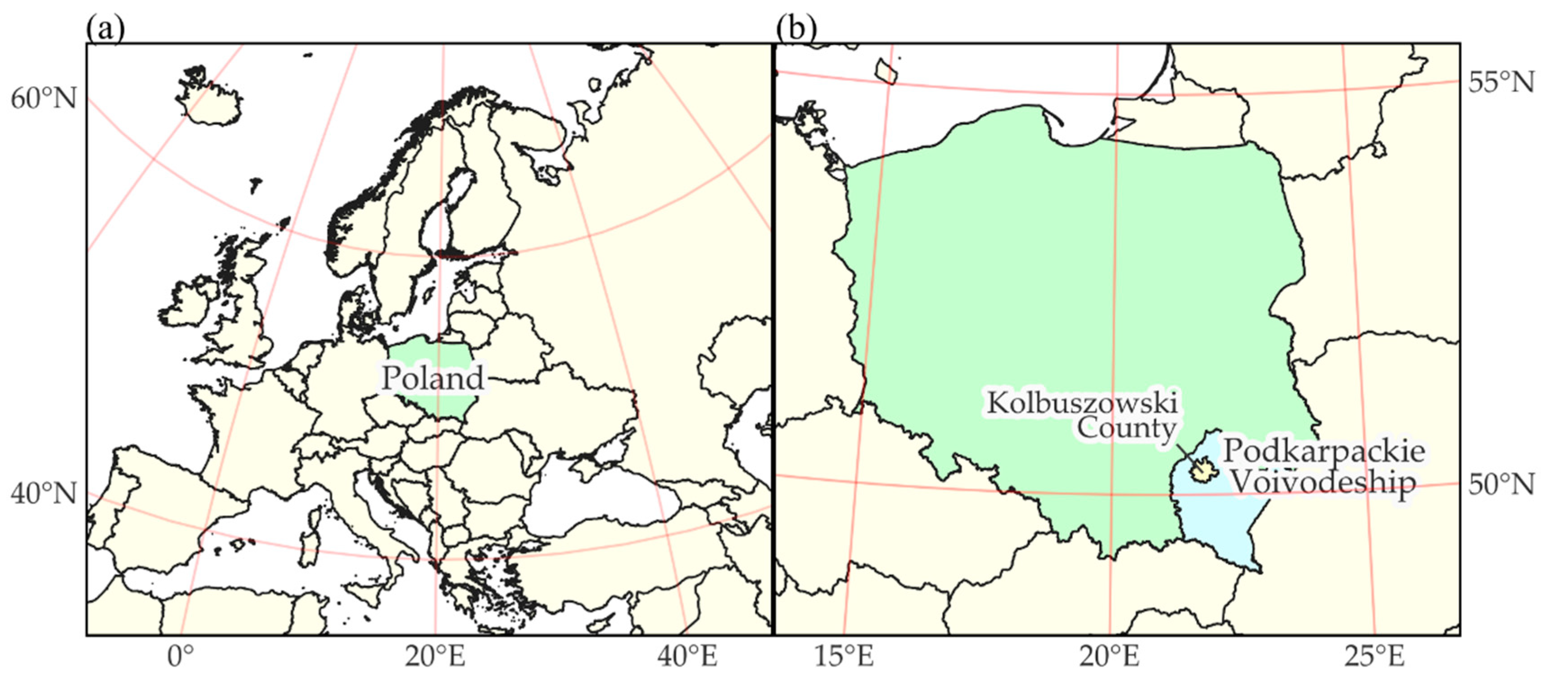
Figure 2.
A simplified diagram of data processing in the research procedure. Source: own elaboration.
Figure 2.
A simplified diagram of data processing in the research procedure. Source: own elaboration.
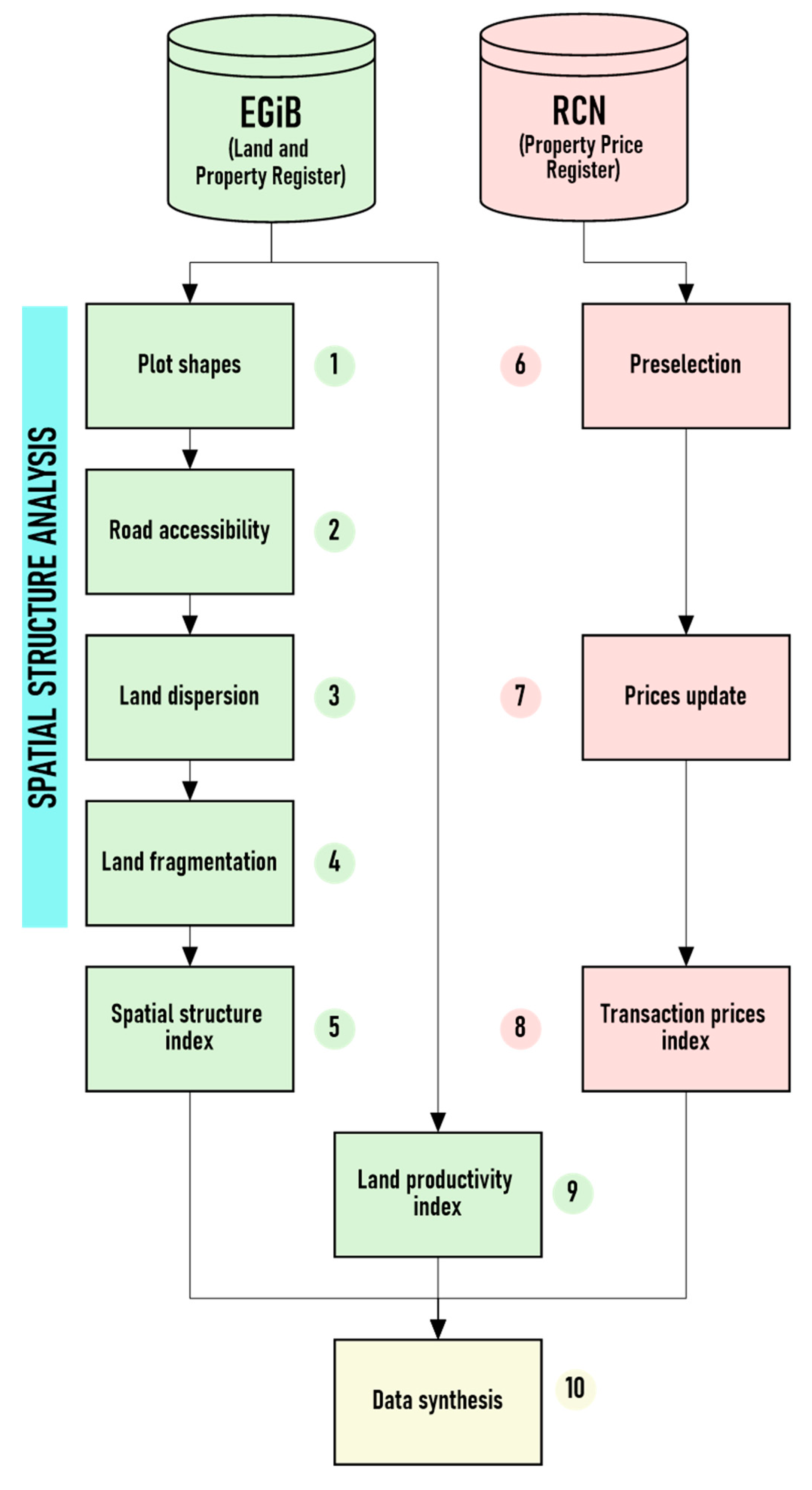
Figure 3.
CPSI index values (plot shape index). Source: own elaboration.
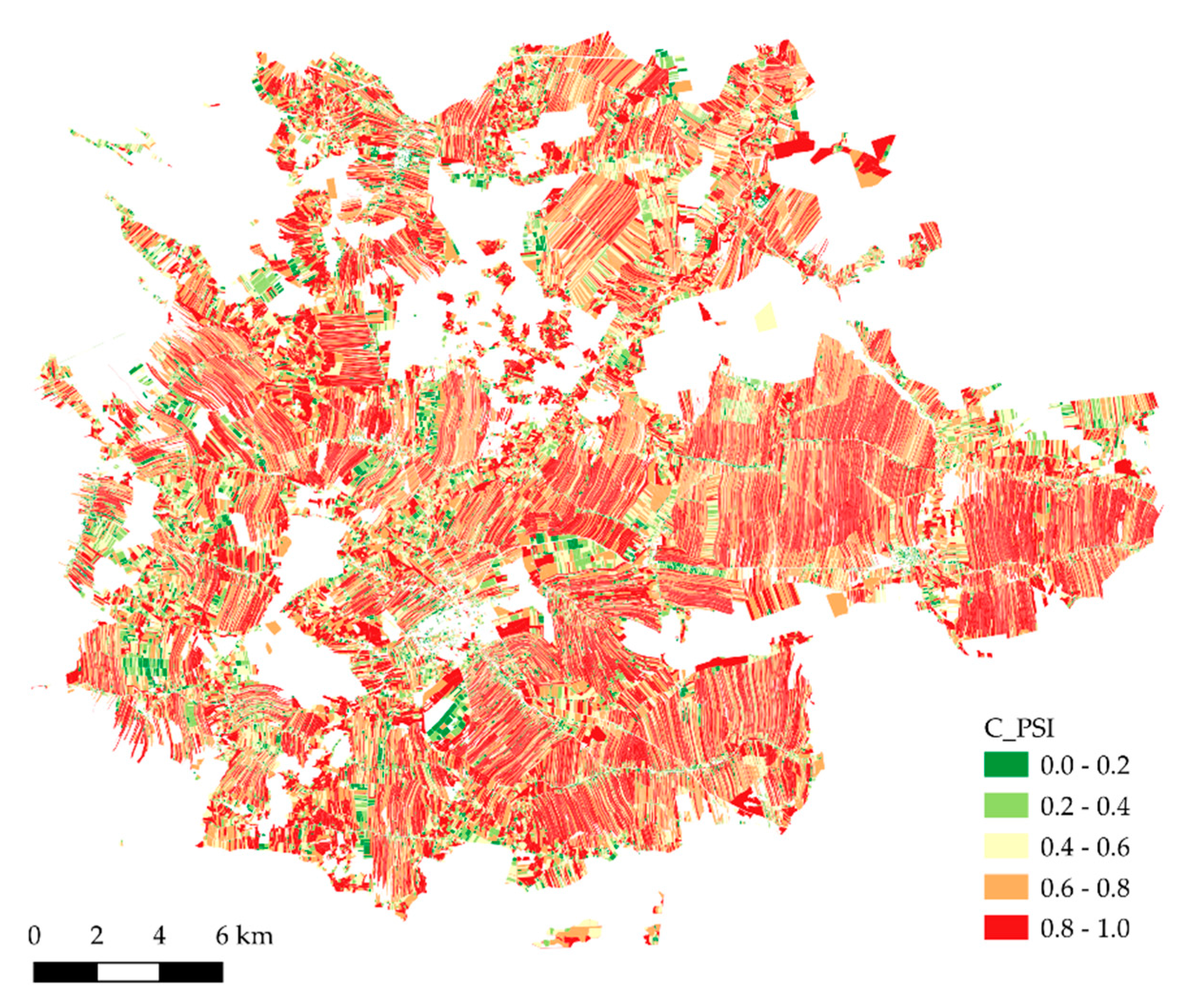
Figure 4.
CATR index values (public road access index) Source: own elaboration.
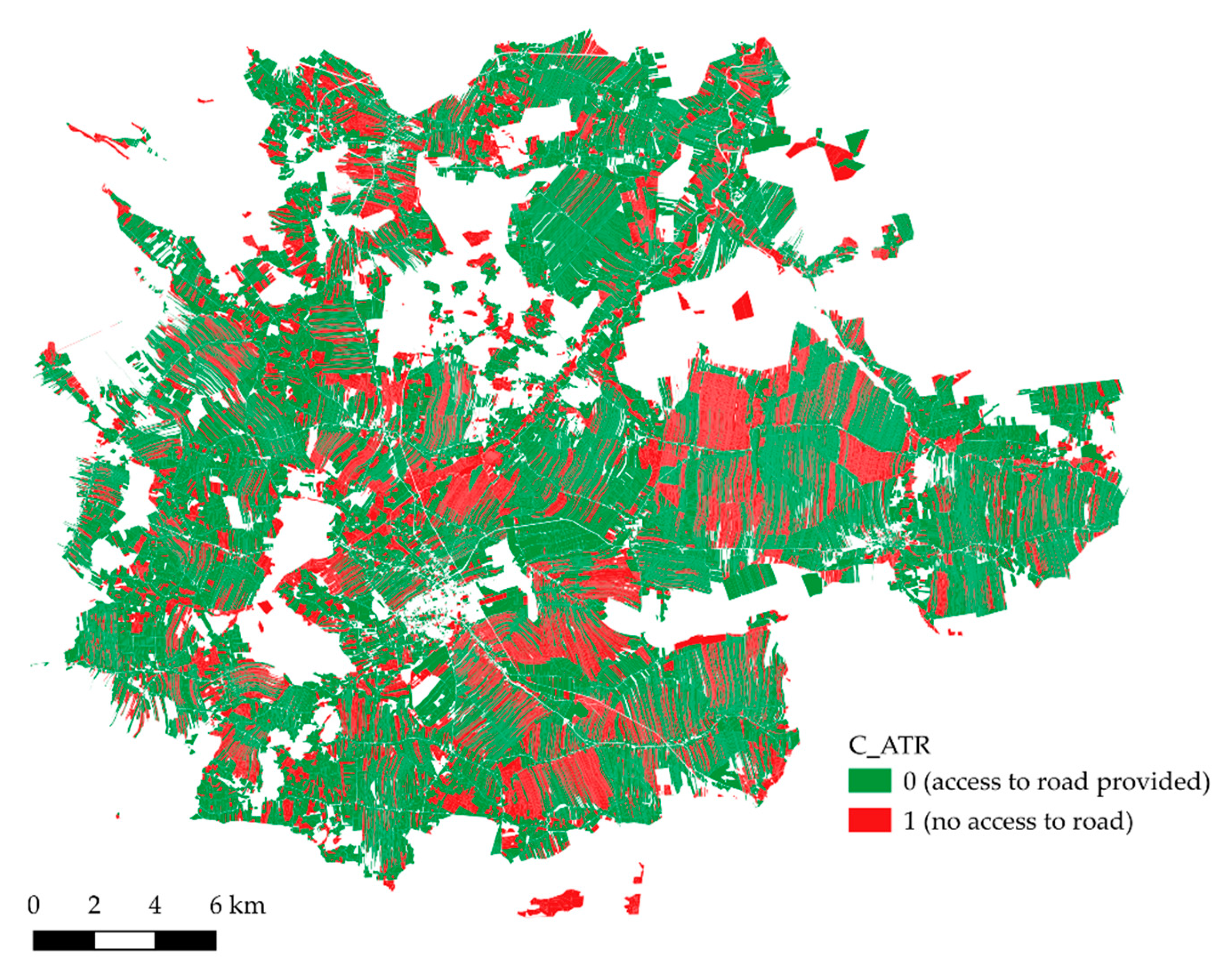
Figure 5.
CDSP index values (land dispersion index) Source: own elaboration.
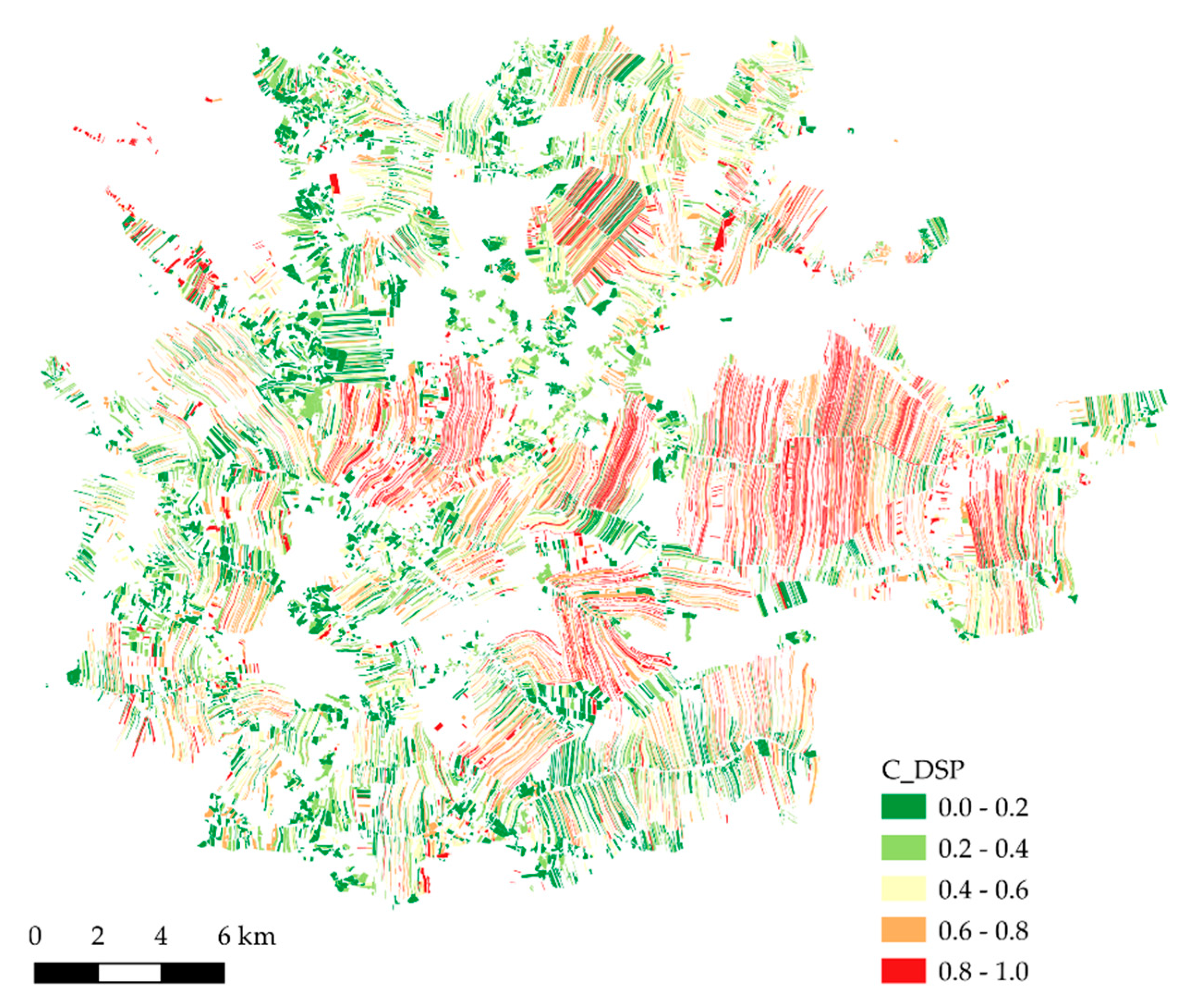
Figure 6.
CFRG index values (land fragmentation index) Source: own elaboration.
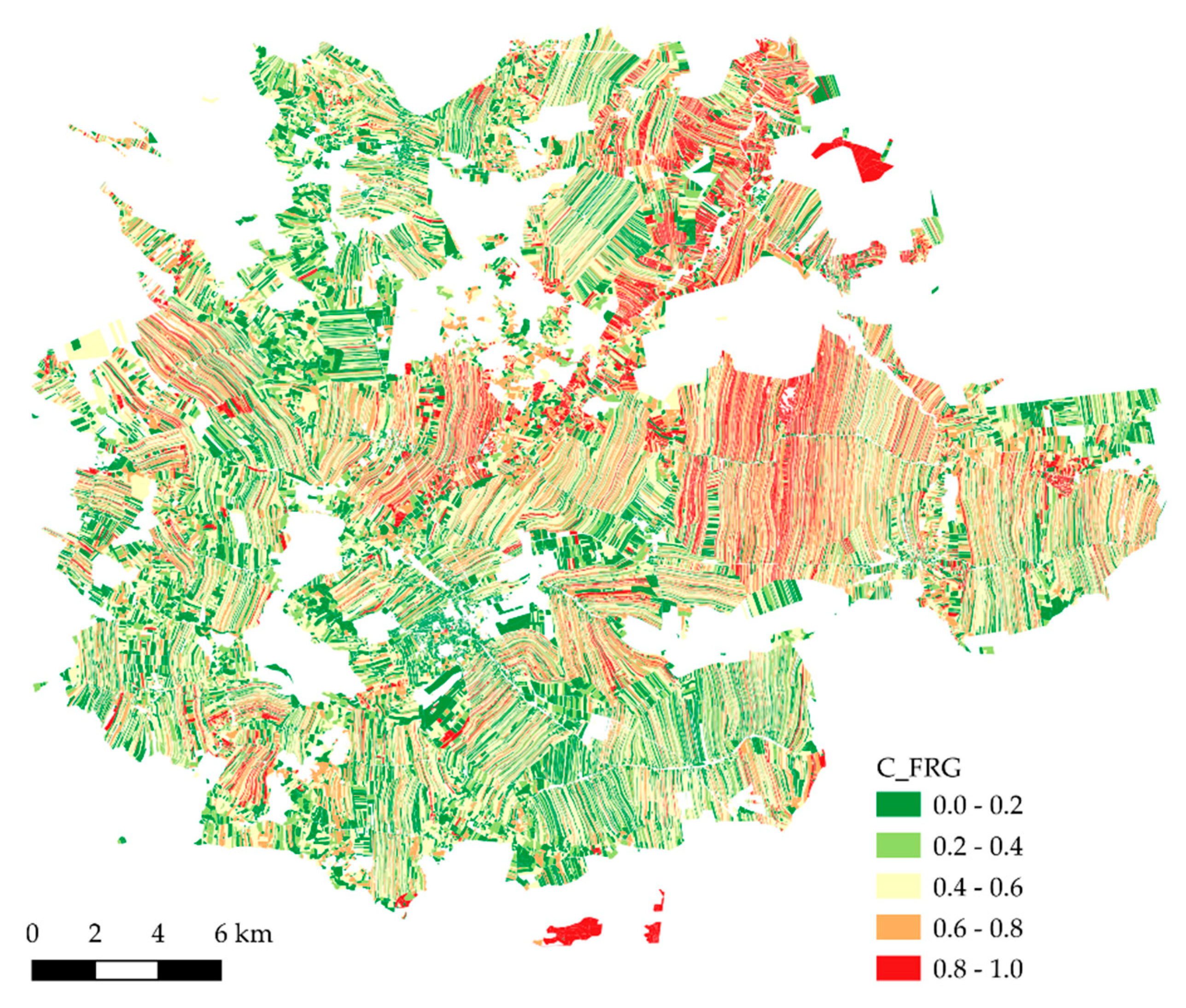
Figure 7.
Synthetic C index values (land consolidation work demand index) Source: own elaboration.
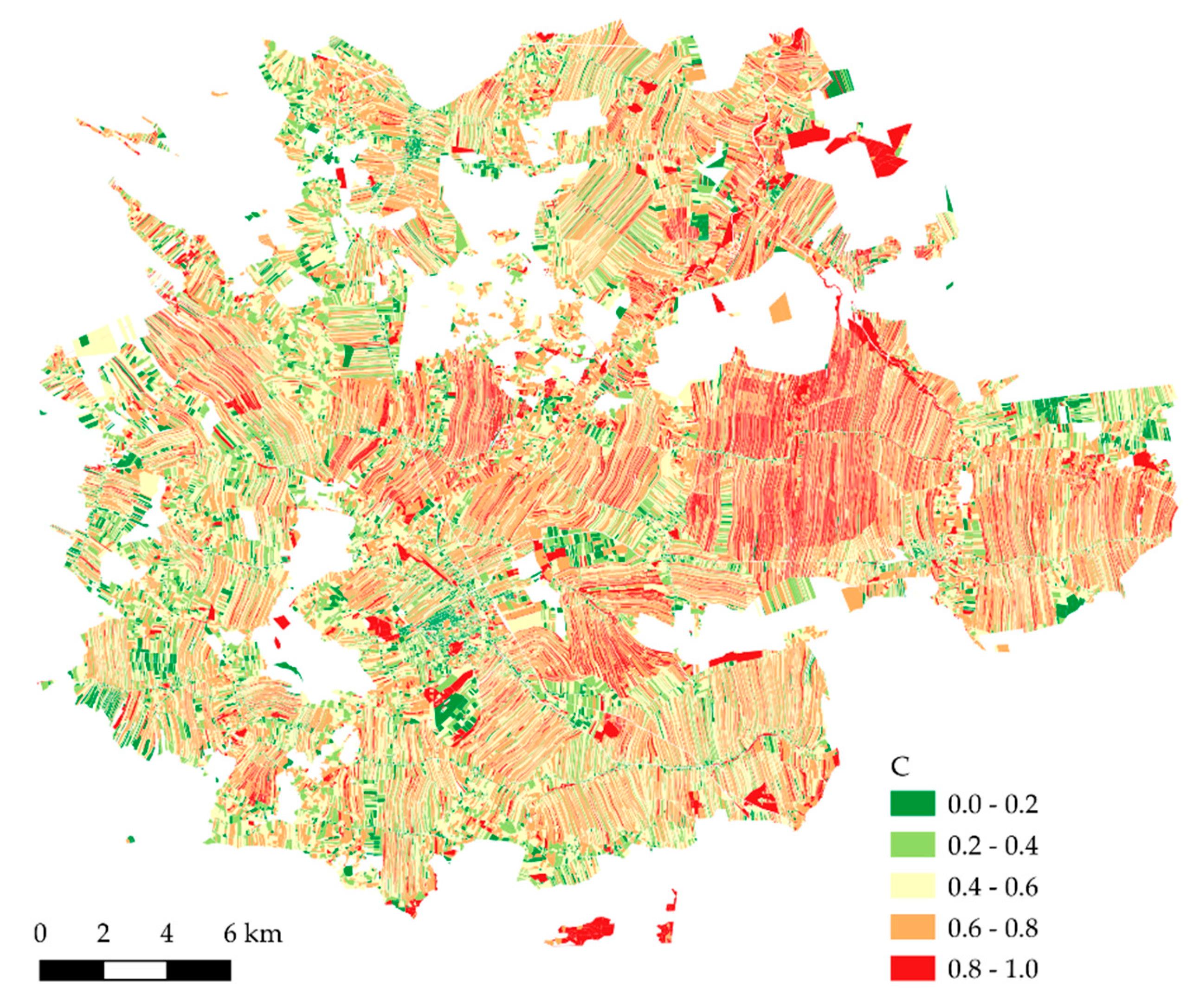
Figure 8.
P index values (unit land transaction price index). Source: own elaboration.
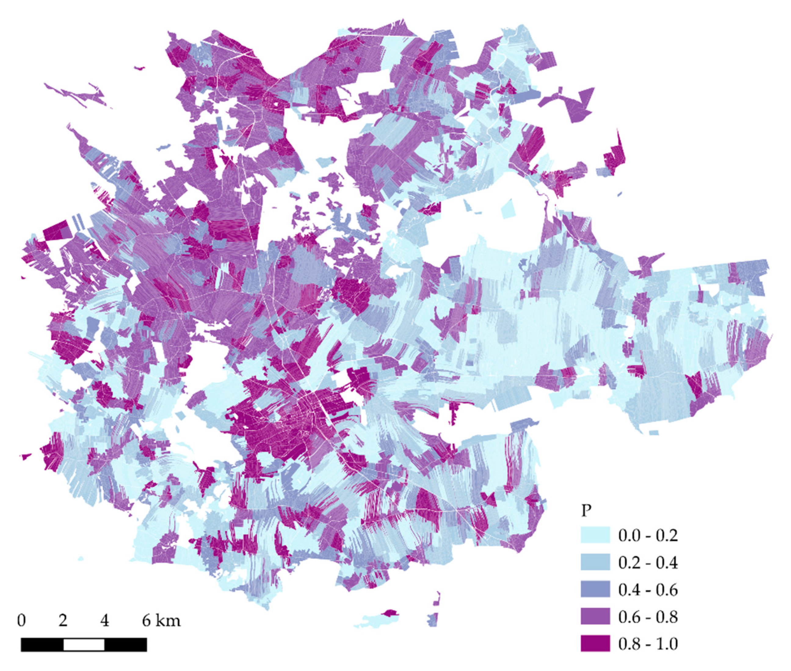
Figure 9.
Q index values (land productive value index) Source: own elaboration.
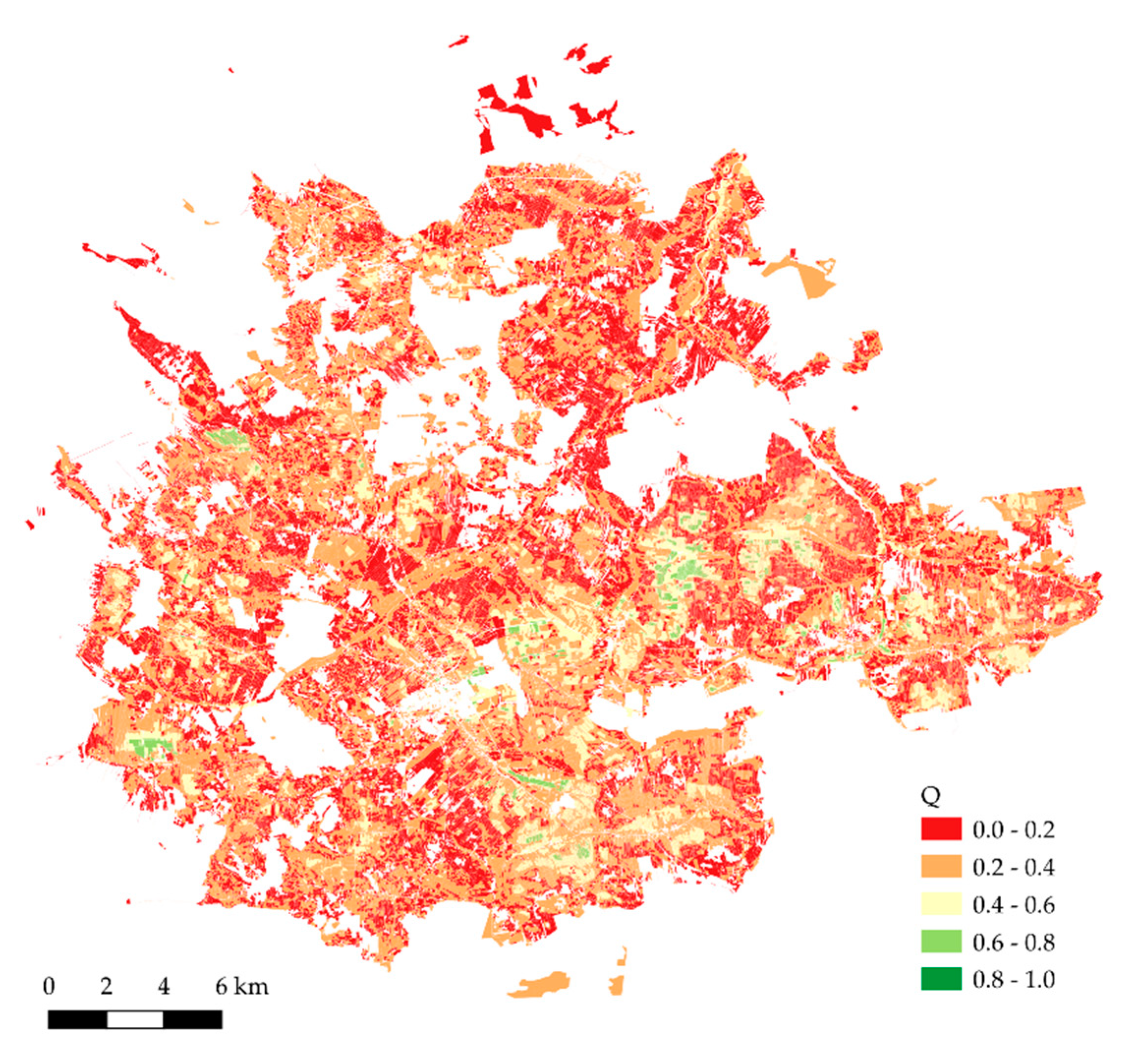
Figure 10.
Values of C index aggregated for cadastral districts (villages or towns). Numerical designations correspond to ordinal numbers in Table 4. Source: own elaboration.
Figure 10.
Values of C index aggregated for cadastral districts (villages or towns). Numerical designations correspond to ordinal numbers in Table 4. Source: own elaboration.
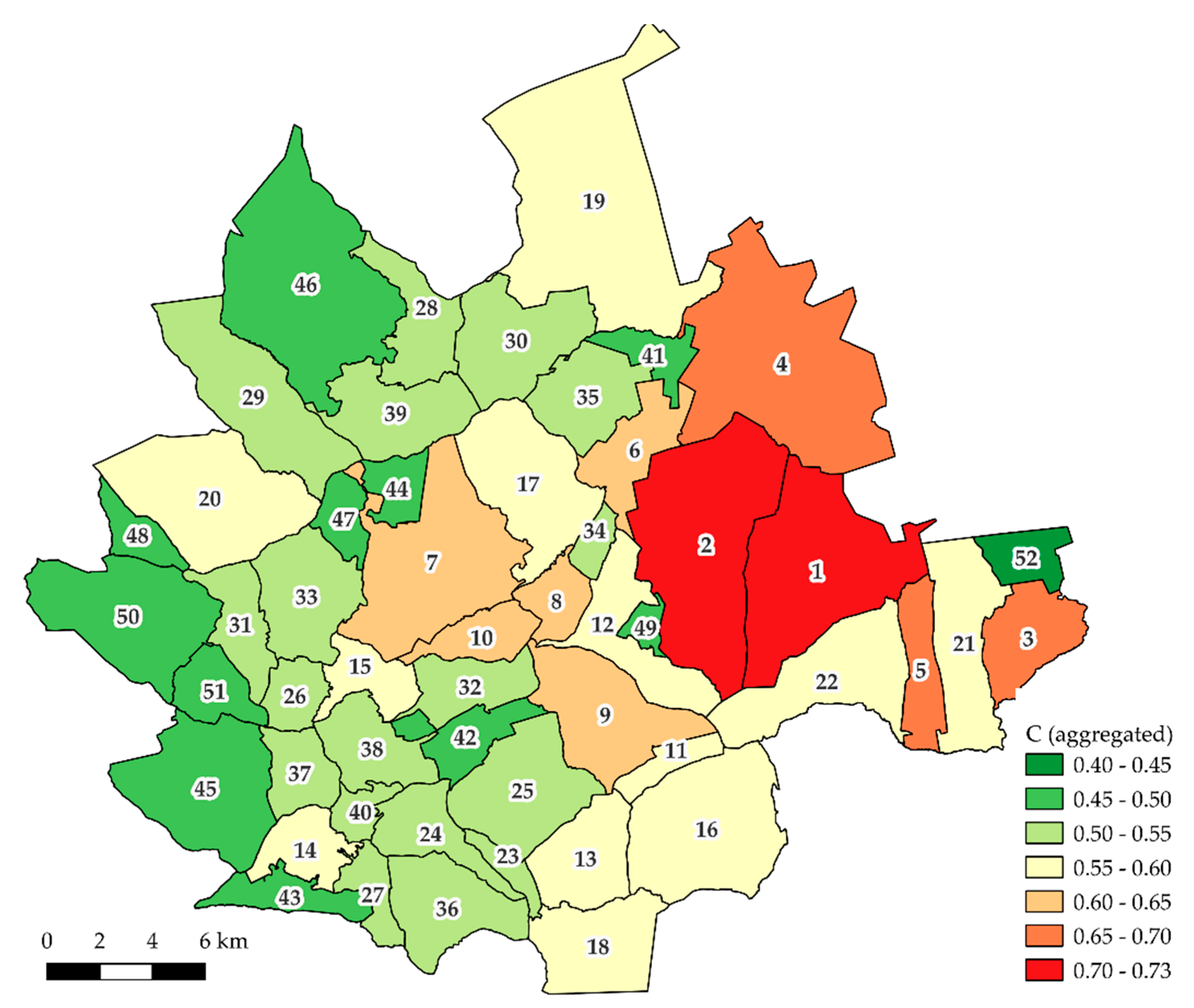
Figure 11.
Values of P index aggregated for cadastral districts (villages or towns). Numerical designations correspond to ordinal numbers in Table 4. Source: own elaboration.
Figure 11.
Values of P index aggregated for cadastral districts (villages or towns). Numerical designations correspond to ordinal numbers in Table 4. Source: own elaboration.
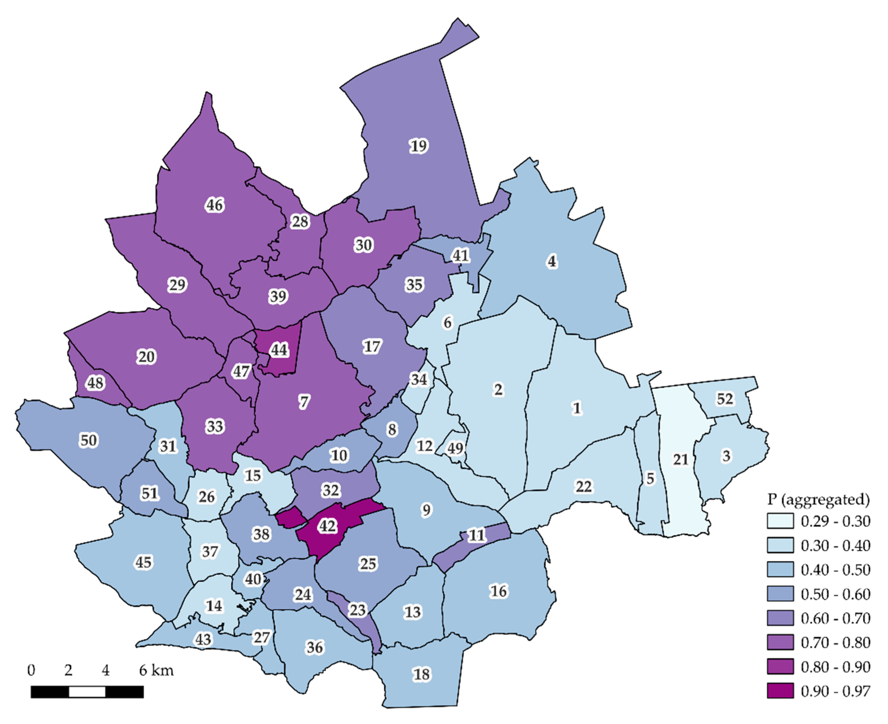
Figure 12.
The distribution and classification of the values of C and P indices for the cadastral districts under study. Source: own elaboration.
Figure 12.
The distribution and classification of the values of C and P indices for the cadastral districts under study. Source: own elaboration.
Figure 13.
Spatial distribution of cadastral districts assigned to individual groups. Numerical designations correspond to ordinal numbers in Table 4. Source: own elaboration.
Figure 13.
Spatial distribution of cadastral districts assigned to individual groups. Numerical designations correspond to ordinal numbers in Table 4. Source: own elaboration.
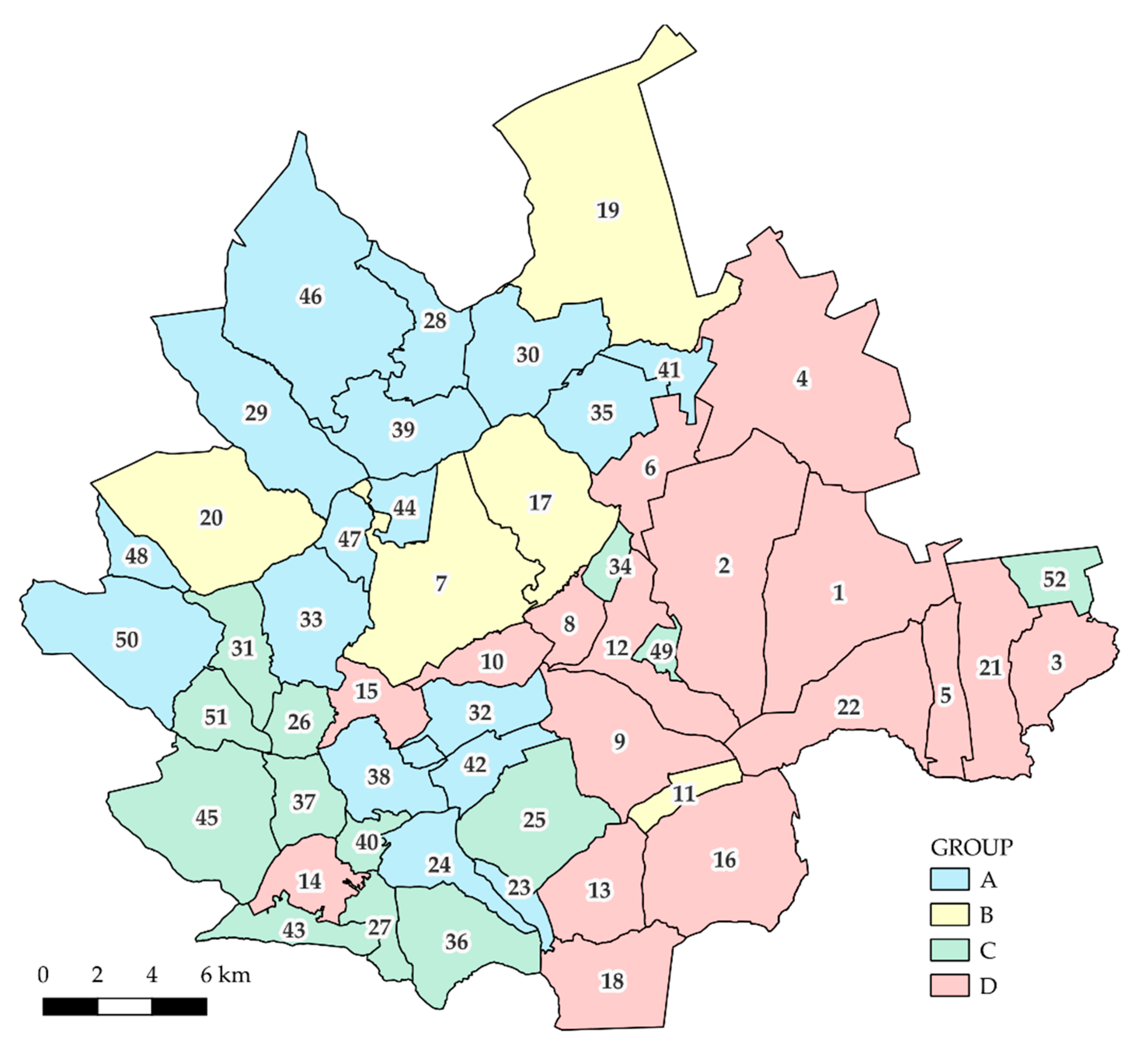
Figure 14.
Classification of the localities under study with regard to the values of C and P indices along with the Q index values. Numerical designations correspond to ordinal numbers in Table 4. Source: own elaboration.
Figure 14.
Classification of the localities under study with regard to the values of C and P indices along with the Q index values. Numerical designations correspond to ordinal numbers in Table 4. Source: own elaboration.
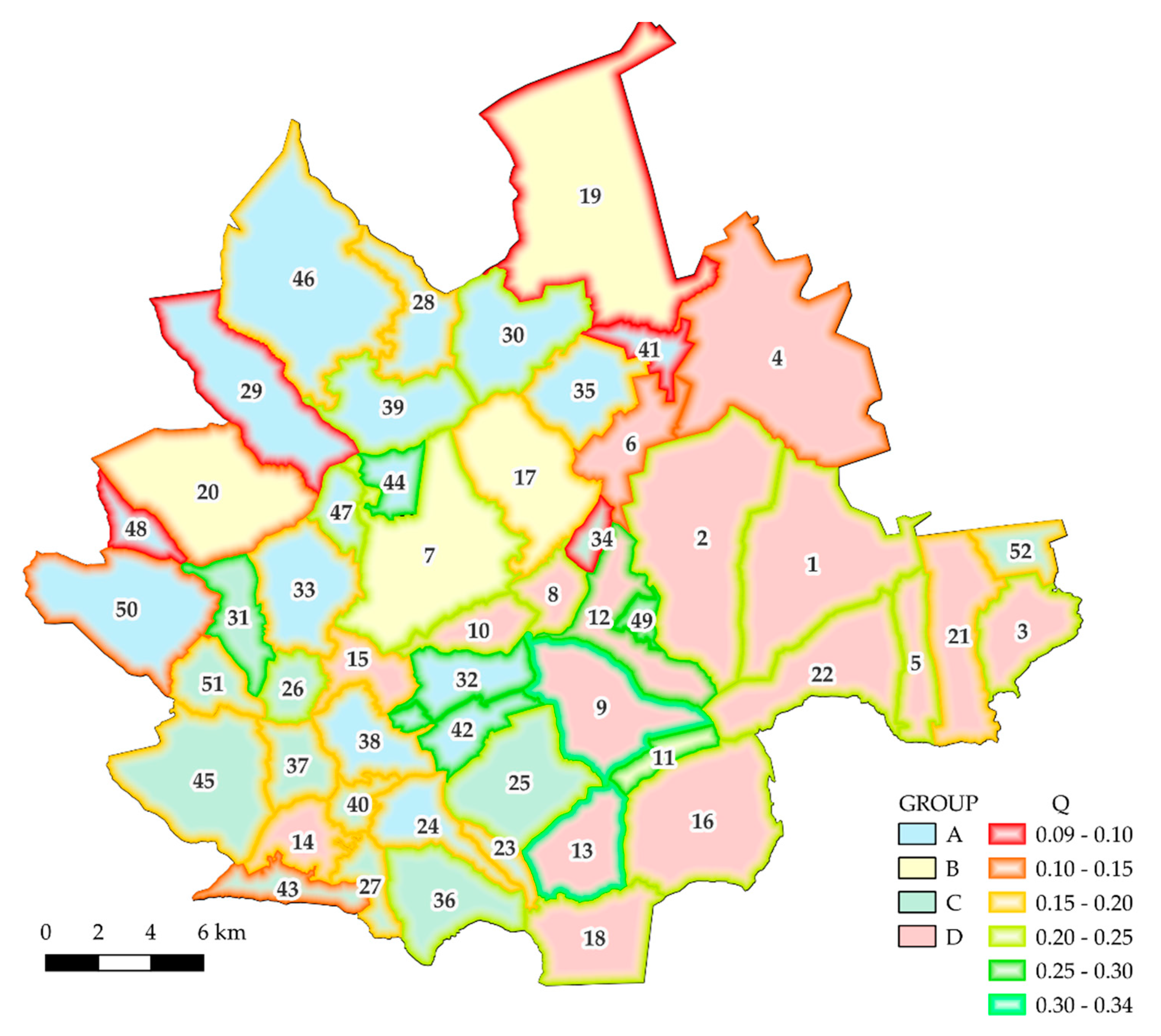

Table 1.
Description of data in use. Source: own elaboration.
| Type of data | Source | Use |
|---|---|---|
| Land and Property Register database | County Starosty in Kolbuszowa | analysis of factors determining the demand for land consolidation works |
| property price register | County Starosty in Kolbuszowa | analysis of land prices based on historical transactions |
Table 2.
P attribute values as a function of the transaction price. Source: own elaboration.
| Price range [PLN/ha] | P |
|---|---|
| 0.00 – 10,000.00 | 0.0 |
| 10,000.01 – 15,000.00 | 0.1 |
| 15,000.01 – 20,000.00 | 0.2 |
| 20,000.01 – 25,000.00 | 0.3 |
| 25,000.01 – 30,000.00 | 0.4 |
| 30,000.01 – 40,000.00 | 0.5 |
| 40,000.01 – 60,000.00 | 0.6 |
| 60,000.01 – 80,000.00 | 0.7 |
| 80,000.01 – 100,000.00 | 0.8 |
| 100,000.01 – 150,000.00 | 0.9 |
| > 150,000.00 | 1.0 |
Table 3.
The values of the Q index of agricultural land suitability, based on the scores of individual land classes. Source: [48], own elaboration.
Table 3.
The values of the Q index of agricultural land suitability, based on the scores of individual land classes. Source: [48], own elaboration.
| Land type | Land class | Score | Q |
|---|---|---|---|
| arable land | I | 100 | 1.00 |
| II | 92 | 0.91 | |
| IIIa | 83 | 0.80 | |
| IIIb | 70 | 0.65 | |
| IVa | 57 | 0.49 | |
| IVb | 40 | 0.29 | |
| V | 30 | 0.18 | |
| VI/VIz | 18 | 0.04 | |
| grassland (meadows, pastures) | I | 90 | 0.88 |
| II | 80 | 0.76 | |
| III | 65 | 0.59 | |
| IV | 45 | 0.35 | |
| V | 38 | 0.27 | |
| VI | 15 | 0.00 |
Table 4.
The ranking of villages under study in terms of the aggregated C and P index values. Source: own elaboration.
Table 4.
The ranking of villages under study in terms of the aggregated C and P index values. Source: own elaboration.
| Item | Locality name | Area (ha) | C | Ranking position according to C | P | Ranking position according to P |
|---|---|---|---|---|---|---|
| 1. | Wola Raniżowska | 3325.21 | 0.73 | 1 | 0.33 | 50 |
| 2. | Lipnica | 3883.43 | 0.72 | 2 | 0.32 | 51 |
| 3. | Mazury | 1158.43 | 0.67 | 3 | 0.40 | 40 |
| 4. | Wilcza Wola | 4694.43 | 0.66 | 4 | 0.50 | 27 |
| 5. | Staniszewskie | 844.62 | 0.66 | 5 | 0.36 | 46 |
| 6. | Kopcie | 1065.93 | 0.65 | 6 | 0.39 | 42 |
| 7. | Cmolas | 3167.71 | 0.64 | 7 | 0.72 | 9 |
| 8. | Mechowiec | 599.91 | 0.63 | 8 | 0.51 | 25 |
| 9. | Werynia | 1948.27 | 0.63 | 9 | 0.44 | 33 |
| 10. | Zarębki | 703.91 | 0.61 | 10 | 0.52 | 23 |
| 11. | Kłapówka | 409.71 | 0.60 | 11 | 0.61 | 18 |
| 12. | Dzikowiec | 1408.53 | 0.60 | 12 | 0.35 | 47 |
| 13. | Kupno | 1253.21 | 0.60 | 13 | 0.46 | 30 |
| 14. | Hucisko | 791.05 | 0.60 | 14 | 0.35 | 49 |
| 15. | Świerczów | 729.41 | 0.60 | 15 | 0.40 | 41 |
| 16. | Widełka | 2725.11 | 0.59 | 16 | 0.46 | 31 |
| 17. | Poręby Dymarskie | 2124.21 | 0.58 | 17 | 0.69 | 14 |
| 18. | Poręby Kupieńskie | 1510.57 | 0.57 | 18 | 0.50 | 28 |
| 19. | Krzątka | 5408.81 | 0.57 | 19 | 0.66 | 15 |
| 20. | Ostrowy Tuszowskie | 2747.32 | 0.57 | 20 | 0.71 | 11 |
| 21. | Zielonka | 1716.47 | 0.57 | 21 | 0.29 | 52 |
| 22. | Raniżów | 2028.56 | 0.56 | 22 | 0.35 | 48 |
| 23. | Bukowiec | 296.13 | 0.55 | 23 | 0.70 | 13 |
| 24. | Domatków | 943.14 | 0.55 | 24 | 0.56 | 20 |
| 25. | Kolbuszowa Górna | 1843.33 | 0.55 | 25 | 0.51 | 26 |
| 26. | Siedlanka | 545.14 | 0.55 | 26 | 0.40 | 38 |
| 27. | Huta Przedborska | 497.15 | 0.54 | 27 | 0.44 | 34 |
| 28. | Majdan Królewski | 1117.53 | 0.54 | 28 | 0.79 | 3 |
| 29. | Ostrowy Baranowskie | 2346.31 | 0.54 | 29 | 0.71 | 12 |
| 30. | Brzostowa Góra | 1722.74 | 0.54 | 30 | 0.73 | 8 |
| 31. | Kosowy | 870.99 | 0.54 | 31 | 0.49 | 29 |
| 32. | Kolbuszowa Dolna | 921.72 | 0.53 | 32 | 0.63 | 16 |
| 33. | Trzęsówka | 1528.34 | 0.53 | 33 | 0.75 | 7 |
| 34. | Płazówka | 289.61 | 0.53 | 34 | 0.40 | 39 |
| 35. | Wola Rusinowska | 1244.29 | 0.53 | 35 | 0.63 | 17 |
| 36. | Przedbórz | 1452.92 | 0.52 | 36 | 0.44 | 32 |
| 37. | Trześń | 747.79 | 0.52 | 37 | 0.36 | 45 |
| 38. | Nowa Wieś | 1050.69 | 0.51 | 38 | 0.55 | 22 |
| 39. | Komorów | 1469.92 | 0.51 | 39 | 0.72 | 10 |
| 40. | Zapole | 359.90 | 0.51 | 40 | 0.43 | 36 |
| 41. | Rusinów | 515.25 | 0.50 | 41 | 0.58 | 19 |
| 42. | Kolbuszowa | 797.99 | 0.50 | 42 | 0.97 | 1 |
| 43. | Leszcze | 697.25 | 0.50 | 43 | 0.41 | 37 |
| 44. | Hadykówka | 506.67 | 0.50 | 44 | 0.83 | 2 |
| 45. | Niwiska | 2388.05 | 0.49 | 45 | 0.43 | 35 |
| 46. | Huta Komorowska | 4047.08 | 0.48 | 46 | 0.77 | 5 |
| 47. | Jagodnik | 490.51 | 0.48 | 47 | 0.77 | 6 |
| 48. | Toporów | 482.95 | 0.48 | 48 | 0.78 | 4 |
| 49. | Nowy Dzikowiec | 214.97 | 0.47 | 49 | 0.39 | 43 |
| 50. | Przyłęk | 2393.22 | 0.46 | 50 | 0.56 | 21 |
| 51. | Hucina-Staszówka | 696.45 | 0.46 | 51 | 0.52 | 24 |
| 52. | Korczowiska | 589.04 | 0.40 | 52 | 0.39 | 44 |
Table 5.
A simplified statistical description of the C and P indices calculated for the cadastral districts of Kolbuszowski County. Source: own elaboration.
Table 5.
A simplified statistical description of the C and P indices calculated for the cadastral districts of Kolbuszowski County. Source: own elaboration.
| Variable | Minimum | Maximum | Average value | Standard deviation | r-Pearson’s correlation coefficient |
|---|---|---|---|---|---|
| C | 0.40 | 0.73 | 0.56 | 0.07 | -0.35 |
| P | 0.29 | 0.97 | 0.54 | 0.16 |
Table 6.
Classification of the cadastral districts under study, as determined by the value of C and P indices. Source: own elaboration.
Table 6.
Classification of the cadastral districts under study, as determined by the value of C and P indices. Source: own elaboration.
| Group | C | P | Number of villages |
|---|---|---|---|
| A | 17 | ||
| B | 5 | ||
| C | 13 | ||
| D | 17 |
Table 7.
A generalised statistical summary of Q index. Source: own elaboration.
| Variable | Minimum | Maximum | Average value | Standard deviation |
|---|---|---|---|---|
| Q | 0.09 | 0.34 | 0.20 | 0.06 |
Table 8.
r - Pearson’s coefficients of correlation between the C, P and Q indices aggregated for cadastral districts. Source: own elaboration.
Table 8.
r - Pearson’s coefficients of correlation between the C, P and Q indices aggregated for cadastral districts. Source: own elaboration.
| Variable | C | P | Q |
| C | 1.00 | -0.35 | 0.23 |
| P | -0.35 | 1.00 | -0.10 |
| Q | 0.23 | -0.10 | 1.00 |
Table 9.
The aggregated Q index values for individual groups of localities. Source: own elaboration.
Table 9.
The aggregated Q index values for individual groups of localities. Source: own elaboration.
| Group | Q |
|---|---|
| A | 0.19 |
| B | 0.14 |
| C | 0.21 |
| D | 0.22 |
Disclaimer/Publisher’s Note: The statements, opinions and data contained in all publications are solely those of the individual author(s) and contributor(s) and not of MDPI and/or the editor(s). MDPI and/or the editor(s) disclaim responsibility for any injury to people or property resulting from any ideas, methods, instructions or products referred to in the content. |
© 2023 by the authors. Licensee MDPI, Basel, Switzerland. This article is an open access article distributed under the terms and conditions of the Creative Commons Attribution (CC BY) license (http://creativecommons.org/licenses/by/4.0/).
Copyright: This open access article is published under a Creative Commons CC BY 4.0 license, which permit the free download, distribution, and reuse, provided that the author and preprint are cited in any reuse.


