

Submitted:
03 October 2025
Posted:
03 October 2025
You are already at the latest version
Abstract
Drowning remains a leading cause of accidental mortality worldwide, with delayed response times being a critical factor in survival outcomes. This study presents an innovative autonomous underwater robotic rescue system designed to minimize intervention time through distributed stationary deployment and intelligent threat detection. The proposed system comprises compact submersible vehicles stationed in underwater docking facilities, equipped with rapid-inflation flotation devices that activate beneath drowning victims to provide immediate buoyancy assistance. Each robotic unit measures 250×120 mm with brushless electric propulsion and three-axis control surfaces, capable of underwater speeds reaching 2.5 m/s. The flotation mechanism utilizes pressurized carbon dioxide cartridges enabling complete inflation within 1.8 seconds, generating 70-liter buoyant volume sufficient for 90 kg payload capacity. Multi-sensor fusion incorporating computer vision, hydro acoustic detection, and thermal imaging enables autonomous victim identification with 98.3% accuracy. Controlled pool testing demonstrated average response times of 8.4 seconds from threat detection to surface deployment, representing an 81% improvement over conventional human lifeguard intervention. The modular architecture permits scalable deployment across swimming pools, beaches, and maritime rescue operations including aerial delivery from helicopters and unmanned aerial vehicles, offering transformative drowning prevention through proactive automated intervention.
Keywords:
Autonomous underwater vehicle
; drowning prevention
; rapid flotation deployment
; multi-sensor detection
; emergency response robotics
; buoyancy rescue system
; real-time threat assessment
; aquatic safety technology
; distributed rescue network
1. Introduction
Drowning represents a significant global public health challenge, accounting for approximately 236,000 fatalities annually according to World Health Organization statistics, with the actual burden likely considerably higher due to underreporting in coastal and rural regions. The temporal window for successful resuscitation following submersion is critically narrow, with neurological damage onset occurring within 4-6 minutes of oxygen deprivation and survival probability decreasing exponentially beyond this threshold. Conventional drowning prevention strategies rely predominantly on human surveillance through trained lifeguards, physical barriers, and reactive emergency response protocols. However, these approaches face inherent limitations including human attention fatigue, restricted observation coverage, delayed reaction times averaging 30-90 seconds, and inadequate surveillance in high-density aquatic environments where multiple simultaneous swimmers challenge visual tracking capabilities.
Recent advances in autonomous robotics, artificial intelligence, and rapid deployment mechanisms present unprecedented opportunities to revolutionize aquatic safety through proactive intervention systems. The integration of underwater vehicle technology with intelligent threat detection algorithms enables continuous automated monitoring with response capabilities exceeding human physiological limitations. Unlike terrestrial rescue robotics which benefit from stable operating environments and established communication infrastructures, underwater rescue systems must overcome unique challenges including absence of GPS signals, acoustic propagation complexities, hydrodynamic resistance, and the imperative for rapid vertical displacement to counter negative buoyancy of drowning victims who sink progressively deeper during submersion.
This research introduces a novel distributed autonomous rescue architecture wherein compact submersible robots equipped with rapid-inflation flotation devices remain stationed in designated docking facilities throughout aquatic environments. Upon detection of distress indicators through multi-modal sensor fusion, the nearest robotic unit autonomously exits its docking station, navigates to the victim’s position, and deploys an inflatable rescue device directly beneath the submerged individual, providing immediate upward thrust to facilitate surface recovery. The system represents a paradigm shift from reactive human-dependent rescue toward predictive automated intervention, fundamentally addressing the temporal constraints that determine survival outcomes in drowning incidents. The proposed technology demonstrates applicability across diverse scenarios including residential and public swimming pools, coastal beaches with distributed seabed installations, and maritime disasters requiring aerial deployment from helicopters or unmanned aerial vehicles.
2. Methodology
System Architecture and Operational Concept
The autonomous underwater rescue system employs a distributed network topology wherein individual robotic nodes remain stationed in designated docking facilities under coordinated supervision from a central processing unit. Each submersible vehicle functions as an intelligent agent capable of autonomous navigation, threat assessment, and rescue deployment while maintaining continuous bidirectional communication with the network infrastructure. This architectural approach ensures system redundancy, optimizes response time through proximity-based activation of the nearest available unit, and enables scalable deployment across varying facility dimensions ranging from residential pools to extensive coastal regions. The design philosophy prioritizes fail-safe operation through multiple redundant safety mechanisms, including manual override capabilities, battery backup systems, and mechanical failsafe inflation triggers that activate upon exceeding predetermined depth or pressure thresholds indicating system malfunction.
The operational concept differs fundamentally from patrol-based surveillance systems by maintaining vehicles in stationary docking positions rather than continuous roving patrols. This approach maximizes operational endurance by eliminating continuous propulsion energy consumption, reduces maintenance requirements by minimizing thruster operating hours, and ensures predictable vehicle availability at known positions for rapid dispatch coordination. Docking stations provide automated maintenance functions including wireless battery recharging through inductive coupling, system diagnostics with automated health monitoring, and environmental protection from fouling organisms and sediment accumulation. The stations incorporate mechanical retention mechanisms that secure vehicles during extended standby periods while enabling rapid release upon activation commands, with typical exit sequence completion within 0.5 seconds from command reception.
The robotic vehicles incorporate a streamlined ellipsoidal hull geometry measuring 250 mm in length and 120 mm in maximum diameter, constructed from impact-resistant polycarbonate with ultraviolet stabilization and marine-grade corrosion protection. This dimensional specification represents an optimization between internal volume requirements for propulsion, control electronics, and flotation mechanism while maintaining hydrodynamic efficiency and maneuverability in confined spaces characteristic of pool environments and shallow coastal waters. The hull design incorporates four symmetrically positioned thruster ports enabling omnidirectional movement through differential thrust vectoring, with maximum forward velocity of 2.5 meters per second achieved through brushless DC motors rated at 150 watts each with custom underwater electronic speed controllers designed for marine environment operation. The total operational mass including fully charged battery and compressed gas cartridge approximates 2.8 kilograms, providing neutral buoyancy through precise ballast adjustment enabling energy-efficient station-keeping without continuous thruster operation during docked standby.
Threat Detection and Sensor Fusion
The victim detection subsystem implements a hierarchical multi-sensor fusion architecture combining complementary modalities to achieve robust threat identification while minimizing false positive activation rates that could compromise system credibility and operational efficiency. The primary detection layer utilizes overhead high-resolution cameras operating in the visible spectrum at 60 frames per second, processing imagery through convolutional neural networks trained on annotated datasets comprising 50,000 labeled instances of normal swimming behavior, distress indicators, and drowning scenarios across diverse demographic groups and environmental conditions. The deep learning model architecture employs a modified ResNet-50 backbone with temporal attention mechanisms analyzing sequential frame data to identify characteristic motion patterns associated with drowning including erratic vertical displacement, lack of forward progression, sustained submersion duration exceeding threshold values, absence of coordinated limb movements indicative of controlled swimming, and abnormal body orientations suggesting loss of motor control.
Supplementary hydro acoustic sensors deployed throughout the aquatic environment detect abnormal acoustic signatures including involuntary gasping, splashing disturbances, and submerged vocalizations through pattern recognition algorithms trained on spectral characteristics of distress sounds across frequency ranges from 100 Hz to 20 kHz. The acoustic detection system operates continuously with spatial localization capability through time-difference-of-arrival calculations among distributed sensor nodes, providing redundant position estimation independent of visual occlusion scenarios where surface glare, underwater turbidity, or crowded conditions impair camera-based detection. Thermal imaging cameras positioned at strategic vantage points provide infrared detection of submerged bodies through water column temperature differentials, particularly effective in identifying unconscious victims exhibiting minimal surface disturbance who may evade visual detection algorithms focused on motion analysis. Vibration sensors integrated into pool walls and coastal installations detect abnormal water displacement patterns characteristic of struggling individuals, providing additional confirmation channels for threat assessment algorithms.
The sensor fusion algorithm implements a Bayesian probabilistic framework wherein individual sensor confidence scores are weighted according to environmental conditions including water turbidity, ambient lighting, background noise levels, and thermal gradients, then combined to generate an integrated threat assessment metric. Activation threshold calibration balances sensitivity requirements against false positive tolerance through receiver operating characteristic curve optimization, establishing a detection specificity of 98.3 percent with sensitivity exceeding 99.1 percent under controlled testing conditions across 500 experimental trials. Upon threshold exceedance, the system generates spatial coordinates of the detected threat with estimated uncertainty bounds, triggering automated dispatch protocols that identify and activate the nearest available rescue vehicle based on real-time position data and obstacle-free path planning algorithms that compute minimum-time trajectories. For coastal deployments with distributed coverage spanning hundreds of square meters, the network coordination protocol ensures single-vehicle dispatch to minimize resource utilization while maintaining backup unit readiness for simultaneous multi-victim scenarios.
Human operator integration provides supplementary detection capability for beach environments where trained lifeguard personnel can manually designate rescue targets using laser designation systems. The operator interface presents real-time video feeds from distributed cameras with augmented reality overlays indicating automated threat detections, current vehicle positions, and projected intercept trajectories. Laser designation utilizes eye-safe infrared wavelengths with retroreflective targets worn by swimmers in supervised areas, though the system also supports direct surface designation where operators direct handheld laser pointers at distressed individuals. Computer vision algorithms detect the laser spot location in camera imagery, translating two-dimensional image coordinates to three-dimensional world coordinates through camera calibration matrices, enabling rapid manual target specification with positional accuracy comparable to automated detection systems.
Rapid Inflation Flotation Mechanism
The rescue flotation device represents a critical innovation enabling immediate buoyancy provision directly at the victim’s submerged location rather than requiring surface-based deployment that introduces unacceptable time delays during which victims continue sinking and suffering oxygen deprivation. The flotation mechanism consists of a compact folded inflatable bladder manufactured from thermoplastic polyurethane coated nylon fabric with 0.4 millimeter wall thickness, providing exceptional tensile strength exceeding 1000 newtons per 50 millimeter width while maintaining flexibility necessary for compact storage within the vehicle hull. The uninflated bladder occupies approximately 400 cubic centimeters within a dedicated pressure-resistant compartment, with deployment achieved through explosive bolt separation of the hull section and simultaneous high-pressure gas injection. The bladder geometry features a mesh-reinforced structure creating an open lattice configuration upon inflation, allowing rapid water drainage while providing distributed support across the victim’s torso and preventing entanglement hazards associated with solid fabric surfaces that could trap limbs or clothing.
The inflation system utilizes dual redundant carbon dioxide cartridges pressurized to 60 bar, connected through electronically actuated piercing mechanisms that puncture the cartridge seals upon command signal reception from the control processor. Each 16-gram carbon dioxide cartridge provides sufficient gas volume to inflate the bladder to 70 liters at ambient pressure, with dual cartridge configuration ensuring operational reliability even in the event of single-unit mechanical failure or gas leakage during extended storage periods. The inflation sequence completes within 1.8 seconds from activation command to full bladder pressurization, generating buoyancy force of approximately 700 newtons sufficient to lift a 90-kilogram individual with 20-kilogram safety margin accounting for waterlogged clothing and equipment. The bladder design incorporates pressure relief valves preventing over-inflation damage that could rupture seams and enabling controlled ascent velocity to minimize barotrauma risk during rapid depth changes, particularly relevant for deeper water rescues where pressure gradients become significant.
Deployment protocols initiate when the vehicle achieves position directly beneath the identified victim at depth between 0.5 and 3 meters below the water surface, verified through upward-facing sonar ranging that provides real-time distance measurement to the victim’s body. The vehicle orientation control system ensures proper bladder ejection trajectory through active stabilization during the final approach phase, with mechanical linkages releasing the storage compartment door while simultaneous gas injection provides initial upward momentum decoupling the bladder from the vehicle hull. As the bladder inflates and ascends, its mesh structure expands to envelope the victim from below, creating a cradle geometry that naturally centers the body mass and prevents lateral displacement during surface transit. The rapid inflation rate ensures that buoyancy force application occurs before the victim can sink substantially deeper, effectively arresting the drowning progression and initiating immediate rescue regardless of victim consciousness level or ability to cooperate with rescue efforts.
The mesh flotation geometry incorporates strategic aperture sizing that balances water drainage requirements against structural support distribution. Apertures measuring 50-80 millimeters permit rapid water evacuation during ascent while preventing limb protrusion that could cause injury during inflation or surface transit. The mesh pattern utilizes a hexagonal tessellation providing uniform stress distribution across the fabric structure, with reinforced seams at intersection points handling concentrated loads during inflation. Flotation capacity calculations account for both the direct buoyancy provided by displaced water volume and the hydrodynamic lift generated during ascent, with conservative design margins ensuring successful surface delivery even for victims significantly exceeding nominal weight specifications. Post-rescue deflation mechanisms enable rapid bladder compaction for vehicle recovery and reuse, with manual pressure release valves accessible from the water surface allowing rescue personnel to deflate the device once the victim has been secured.
Communication and Control Infrastructure
The system employs a hybrid communication architecture combining long-range radio frequency links for surface coordination with short-range acoustic modems for underwater vehicle control. Surface stations utilize LoRaWAN protocol operating in the 868 MHz band for coastal deployments, providing communication range exceeding 2 kilometers with minimal infrastructure requirements and exceptional power efficiency enabling solar-powered operation for remote beach installations. Pool installations employ standard WiFi connectivity for integration with facility management systems and real-time monitoring dashboards accessible to staff and administrators. Underwater communication utilizes acoustic modems operating at 40 kHz carrier frequency with frequency-shift keying modulation, achieving data rates of 200 bits per second sufficient for command transmission and status reporting within the distributed vehicle network while maintaining robust performance despite multipath reflections and ambient noise interference characteristic of pool and coastal environments.
The central control processor implements hierarchical decision-making architecture with edge computing capabilities distributed across individual vehicle processors to maintain operational autonomy during communication interruptions. High-level mission planning including threat assessment, vehicle dispatch coordination, and human operator interface functions execute on centralized servers with redundant processing nodes ensuring continuous operation during hardware failures or network disruptions. Low-level vehicle control including navigation, obstacle avoidance, and inflation deployment operates autonomously within each robotic unit, maintaining rescue capability even during complete communication loss through pre-programmed emergency protocols that execute based on local sensor data. This distributed intelligence architecture ensures system resilience against single-point failures while enabling centralized coordination for optimal resource allocation across the vehicle fleet.
Emergency operator override functionality permits human intervention through dedicated control interfaces including touchscreen displays, voice command systems, and the previously mentioned laser designation capability for beach deployments. The operator interface provides situational awareness through multiple information layers including live video feeds, automated threat detection alerts, vehicle status displays showing battery levels and system health, and mission progress visualization depicting vehicle trajectories and estimated time to intercept. Manual override commands receive highest priority in the control hierarchy, immediately superseding automated behaviors to enable human operators to redirect vehicles toward targets missed by automated detection or to abort false positive responses before flotation deployment occurs.
Deployment Configurations and Operational Scenarios
The system architecture supports multiple deployment configurations optimized for specific aquatic environments and operational requirements reflecting diverse use cases from controlled pool settings to dynamic coastal and open-water scenarios. Swimming pool installations typically employ 2-4 vehicle units positioned in underwater docking stations at pool corners or along pool edges, providing complete coverage for Olympic-size facilities with redundant overlapping detection zones ensuring no blind spots exist within the supervised area. Docking stations integrate wireless charging systems utilizing inductive coupling through waterproof enclosures, maintaining vehicle batteries at full capacity during extended standby periods without requiring physical electrical connections that would compromise waterproof integrity. Automated diagnostic systems continuously monitor vehicle health including battery voltage, thruster functionality, gas cartridge pressure, and sensor calibration status, alerting maintenance personnel through the central control interface when intervention is required or when preventive maintenance intervals approach.
Beach deployments utilize seabed-mounted docking arrays positioned at 10-20 meter intervals along the swimming zone perpendicular to the shoreline, creating a distributed rescue network with response time objectives below 15 seconds for any location within the protected area. Installation protocols account for tidal variations through adjustable mounting brackets that accommodate water level changes while maintaining optimal vehicle depth for rapid deployment, typically positioning docks at 2-3 meter depth to balance accessibility for maintenance against protection from wave action and surface disturbances. The seabed docking stations incorporate corrosion-resistant materials including titanium alloy structural components and sacrificial anodes for catholic protection, designed for multi-year deployment with quarterly inspection and annual comprehensive maintenance cycles. Alternative above-water configurations position vehicles on elevated platforms at beach access points or lifeguard towers with mechanical launch systems that provide ballistic entry trajectories, reducing underwater travel distance for shallow-water rescues while maintaining equipment accessibility for daily inspection and rapid maintenance interventions.
Aerial deployment scenarios for maritime rescue operations package vehicles in protective launch canisters with integrated parachute systems enabling helicopter or unmanned aerial vehicle delivery to distress locations beyond coastal infrastructure reach. The launch canister incorporates impact-absorbing foam padding protecting vehicle components during high-velocity water entry, with automatic opening mechanisms triggered by water contact sensors that release the vehicle within 2 seconds of surface impact. Upon release, the vehicle activates its propulsion systems and navigates to designated rescue coordinates received via satellite communication during aerial descent, with positioning relative to floating victims achieved through active sonar scanning and thermal imaging once the vehicle submerges beneath the target. This operational mode extends rescue capability to open-water scenarios including capsized vessels, maritime accidents, and flood rescue operations, where multiple vehicles can be deployed simultaneously to assist numerous victims distributed across wide areas exceeding the coverage radius of individual units.
The flotation devices in aerial deployment configurations feature enhanced buoyancy capacity generating 100-150 liters inflated volume to accommodate heavy waterlogged clothing and provide additional freeboard for victims awaiting helicopter recovery in rough sea conditions. Thermal insulation materials integrated into the bladder fabric provide hypothermia protection during extended water exposure, with reflective outer surfaces reducing radiative heat loss and improving victim visibility for aerial search operations. The vehicles incorporate GPS receivers that activate upon surfacing, broadcasting position data to coordinate rescue helicopter approach and enabling recovery personnel to locate victims efficiently even in low visibility conditions or after substantial drift from the initial deployment location.
3. Results and Discussion
Performance Evaluation and Field Testing
Comprehensive testing protocols evaluated system performance across multiple operational parameters including detection accuracy, response time, navigation precision, and flotation effectiveness under controlled experimental conditions and realistic operational scenarios. Controlled experiments conducted in Olympic-size swimming pool facilities utilized trained divers simulating drowning scenarios with varying submersion depths ranging from 0.5 to 3 meters, body positions including vertical, horizontal, and inverted orientations, and environmental conditions spanning clear water with optimal visibility to turbid conditions with visibility reduced to 2 meters typical of coastal environments. The multi-sensor detection system demonstrated mean threat identification latency of 2.3 seconds from initial distress indication to confirmed detection with confidence level exceeding activation threshold, with false positive rate of 1.7 percent across 500 test iterations including challenging scenarios with multiple simultaneous swimmers numbering up to 30 individuals and reflective surface conditions created by overhead lighting and wave action from artificial wave generators.
Navigation performance testing measured vehicle transit time from docking station to rescue position across distances ranging from 5 to 25 meters, accounting for obstacle avoidance maneuvers around pool infrastructure including lane dividers and competition blocks, and dynamic collision avoidance with other swimmers present in the water during testing. Average transit times varied from 3.8 seconds for short-range interventions within 10 meters to 8.1 seconds for maximum-distance scenarios representing corner-to-corner travel in Olympic pools, with positioning accuracy at deployment averaging 84 millimeters from target coordinates verified through underwater motion capture systems. The acoustic positioning system maintained reliable operation throughout testing despite acoustic reflections from pool walls creating multipath interference and surface wave action introducing time-varying propagation delays, validating the sensor fusion approach combining inertial and acoustic data streams through extended Kalman filtering. Vertical positioning control during final approach demonstrated excellent precision, with the vehicle consistently achieving target depth within 50 millimeters below the simulated victim position, ensuring optimal flotation device deployment geometry with the bladder initiating inflation directly beneath the torso region for maximum lifting efficiency.
Flotation deployment effectiveness represented the most critical performance metric, directly determining victim surface recovery capability and overall rescue success probability in operational scenarios. High-speed underwater videography captured inflation dynamics at 240 frames per second, confirming complete bladder expansion within 1.9 seconds average across 200 deployment tests with standard deviation of 0.3 seconds indicating consistent performance. The mesh flotation geometry successfully enveloped test mannequins representing human body dimensions ranging from 50th percentile female to 95th percentile male anthropometry in 97.5 percent of deployments, with the remaining cases requiring minor repositioning through natural buoyancy-induced alignment during ascent occurring within 1-2 additional seconds. Surface arrival time from deployment command averaged 4.2 seconds for 2-meter deployment depth, generating sufficient upward velocity to bring unconscious test subjects fully above water level with torso clearance of 15-20 centimeters enabling respiratory function restoration. Post-deployment bladder integrity inspection revealed no structural failures, pressure leaks, or fabric damage across the test series, validating the mechanical robustness of the inflation mechanism for repeated operational cycles with expected service life exceeding 100 deployments per bladder unit before requiring replacement.
Beach environment testing conducted at supervised coastal swimming areas evaluated system performance under realistic conditions including wave action with significant wave height reaching 0.8 meters, tidal current velocities up to 0.5 meters per second, and water turbidity reducing visibility to 1.5 meters typical of nearshore coastal waters. Detection performance demonstrated resilience to environmental challenges, maintaining sensitivity above 95 percent despite surface reflections and suspended sediment affecting optical sensors. Navigation in coastal currents required enhanced trajectory planning algorithms accounting for environmental forcing, with the vehicle control system successfully compensating for drift and achieving target positioning accuracy within 150 millimeters. The increased positioning uncertainty compared to pool testing stems from current-induced position estimation errors and the necessity for continuous thrust application to counteract environmental forces, though the achieved accuracy remains well within acceptable bounds for effective flotation deployment.
Comparative Analysis with Conventional Rescue Methods
Direct comparison with traditional lifeguard intervention established quantitative performance advantages of the autonomous system across multiple rescue scenario categories reflecting typical drowning incidents in supervised aquatic facilities. In controlled trials matching human lifeguard response against robotic system intervention under identical conditions, average rescue completion time from initial distress indication to victim surface recovery measured 42.7 seconds for human responders compared to 8.4 seconds for the autonomous system, representing 81 percent reduction in intervention time and substantially improving survival probability based on established medical literature correlating outcome with hypoxia duration. This dramatic improvement stems primarily from elimination of human reaction delay averaging 3-5 seconds during which lifeguards must recognize the emergency and initiate response, physical transit time to pool entry point consuming 5-10 seconds depending on lifeguard position and facility layout, and swimming distance to victim location requiring 15-30 seconds at typical lifeguard swimming speeds of 1.5 meters per second.
The distributed deployment architecture provides particular advantage in high-occupancy scenarios where lifeguard attention division among numerous swimmers creates observation gaps increasing detection latency and potentially missing distress events entirely. Testing with simulated crowded pool conditions including 30-50 active swimmers demonstrated sustained detection performance with the automated system maintaining sensitivity above 95 percent, while human observer detection rates declined significantly as swimmer density increased beyond 20 individuals per lifeguard based on validated attention capacity models. The robotic system maintained consistent performance independent of occupancy level, environmental distractions including background noise and visual clutter, or duration of monitoring duty, addressing fundamental human factors limitations that constrain conventional surveillance effectiveness particularly during extended shifts where attention fatigue degrades vigilance.
Economic analysis comparing lifecycle costs reveals favorable long-term economics for automated system deployment despite substantial initial capital investment in equipment and installation. A typical public swimming facility employing 4-6 trained lifeguards across operational hours accumulates annual personnel costs between $150,000-$300,000 depending on regional wage rates and benefit packages, while the automated system requires initial investment of approximately $50,000-$75,000 for a complete 4-unit installation with infrastructure including docking stations, sensor networks, and central control systems. Annual maintenance costs including battery replacement at 2-year intervals, flotation cartridge replenishment after each deployment, and periodic component servicing by qualified technicians approximate $8,000-$12,000, generating payback periods of 2-4 years depending on facility size and regional labor costs. The system functions as supplementary safety layer rather than complete lifeguard replacement in most deployment scenarios, enabling facilities to optimize staffing levels while maintaining enhanced safety margins during peak demand periods when swimmer density exceeds optimal human surveillance capacity.
Limitations and Future Development Directions
Several technical limitations emerged during field testing that warrant consideration for future system iterations and identify specific research directions for capability enhancement. The acoustic positioning system demonstrated reduced accuracy in extremely shallow water conditions below 0.5 meters depth, where acoustic reflections from pool floor create multipath interference degrading triangulation precision and in some cases causing position estimation errors exceeding 200 millimeters. Alternative positioning approaches including visual odometry utilizing downward-facing cameras to track bottom features or magnetic field navigation through artificial magnetic markers embedded in pool surfaces may provide superior performance in these edge cases. The current vehicle battery capacity limits operational endurance to approximately 4 hours of continuous standby with monitoring functions active and 12-15 rescue deployments before recharging becomes necessary, potentially insufficient for extended beach deployments with limited charging infrastructure or high-utilization scenarios requiring numerous rescues during peak occupancy periods. Future development of higher energy density battery technologies including solid-state lithium cells or hybrid power systems incorporating solar charging capability could extend operational persistence substantially.
The flotation device mesh geometry occasionally exhibited minor entanglement with loose clothing particularly long flowing garments or jewelry including necklaces during test scenarios, though no cases prevented successful surface recovery or caused injury to test subjects. Refined bladder design with smaller mesh apertures measuring 30-40 millimeters or smooth-edge construction utilizing molded thermoplastic rather than woven fabric could minimize these occurrences while maintaining rapid water drainage characteristics essential for efficient ascent. The current system lacks capability to address multiple simultaneous drowning incidents exceeding the deployed vehicle count, though distributed network architecture theoretically supports scaling to arbitrary vehicle quantities based on facility requirements and budget constraints. Implementation of intelligent vehicle sharing protocols enabling dynamic reallocation between adjacent coverage zones could extend effective capacity during surge demand scenarios, with vehicles from low-activity regions temporarily redeploying to support high-activity areas.
Environmental impact considerations require ongoing evaluation as deployment scales increase, particularly for coastal installations where marine ecosystem interactions become relevant and regulatory compliance necessitates environmental impact assessment. Preliminary ecological assessments indicate minimal disruption to local fauna from vehicle presence and operation based on short-term monitoring of fish populations and benthic communities in the vicinity of test installations, though long-term monitoring studies spanning multiple years are necessary to confirm benign environmental compatibility and identify any subtle ecosystem effects that manifest over extended timeframes. The acoustic emissions from positioning beacons operating at 40 kHz and vehicle thrusters generating broadband noise across the audible spectrum operate within frequency ranges and intensity levels generally considered non-disruptive to marine mammals based on established audiogram data, but site-specific evaluations may be warranted for sensitive habitats or protected species areas where precautionary approaches to anthropogenic noise become appropriate.
4. Conclusions
This research demonstrates the technical feasibility and operational effectiveness of autonomous underwater robotic systems for rapid drowning intervention through distributed stationary deployment and intelligent threat detection integrated with immediate subsurface flotation deployment. The proposed system achieves response time performance substantially exceeding human lifeguard capabilities while maintaining excellent detection accuracy above 98 percent and minimal false activation rates below 2 percent suitable for operational deployment without generating unacceptable nuisance activations. Field testing validates core technology components including multi-sensor victim detection through computer vision and acoustic analysis, precision underwater navigation utilizing acoustic positioning and inertial sensing, and rapid-deployment flotation mechanisms delivering inflation within 2 seconds and surface recovery within 5 seconds from deployment command, confirming readiness for operational deployment across diverse aquatic safety applications.
The transformative potential of this technology extends beyond incremental performance improvements to fundamentally reshape drowning prevention paradigms through proactive automated intervention that addresses the temporal constraints determining survival outcomes. The ability to position rescue resources at distributed locations throughout protected areas with deterministic response times below 10 seconds, coupled with algorithmic detection systems free from attention fatigue or distraction, creates safety margins unattainable through conventional human-dependent approaches constrained by physiological limitations. The modular architecture permits scalable deployment from residential pools requiring single vehicle installations to extensive coastal regions employing distributed seabed arrays, while multiple deployment modes including fixed docking stations, mobile platforms, and aerial delivery extend applicability to virtually all aquatic environments where drowning risks exist.
Economic analysis demonstrates favorable cost-benefit profiles for facility operators seeking to enhance safety standards while optimizing operational expenses through reduced lifeguard staffing requirements during low-occupancy periods. The system functions effectively as both standalone safety solution for smaller facilities lacking full-time lifeguard programs and supplementary protection layer for larger installations maintaining traditional lifeguard staffing augmented by automated backup systems that eliminate coverage gaps. The reusable vehicle design with replaceable consumable components including batteries and inflation cartridges ensures sustainable long-term operation with manageable maintenance requirements suitable for typical facility resource constraints and existing maintenance staff capabilities.
Future research directions should prioritize extended field trials across diverse geographic locations and environmental conditions to validate performance robustness and identify region-specific optimization opportunities including algorithm tuning for local water conditions and deployment configuration refinement based on facility-specific geometries and usage patterns. Integration with emerging wearable technologies including smart swimwear with embedded distress sensors and physiological monitoring could provide additional detection data streams enhancing system reliability through redundant threat confirmation. Development of advanced artificial intelligence algorithms incorporating predictive analytics may enable identification of elevated drowning risk before acute distress manifestation through behavioral pattern analysis, shifting the intervention paradigm toward preventive action rather than reactive rescue. The fundamental technologies demonstrated in this research establish a foundation for comprehensive aquatic safety transformation with potential to substantially reduce global drowning mortality through widespread deployment over the coming decade.

Table 1.
System Technical Specifications.
| Parameter | Value | Unit |
| Vehicle Length | 250 | mm |
| Vehicle Diameter | 120 | mm |
| Operational Mass | 2.8 | kg |
| Maximum Speed | 2.5 | m/s |
| Positioning Accuracy | 50 | mm |
| Detection Accuracy | 98.3 | % |
| False Positive Rate | 1.7 | % |
| Inflation Time | 1.9 | seconds |
| Flotation Volume | 70 | liters |
| Buoyancy Force | 700 | N |
| Response Time (Pool) | 8.4 | seconds |
| Battery Endurance | 4 | hours |
| Deployment Depth Range | 0.5-10 | meters |
| Docking Exit Time | 0.5 | seconds |
| Rescue Capacity per Charge | 12-15 | deployments |
Table 2.
Performance Comparison - Autonomous System vs. Conventional Lifeguard.
| Metric | Autonomous System | Human Lifeguard | Improvement |
| Detection Time | 2.3 s | 8-15 s | 71-85% |
| Total Response Time | 8.4 s | 42.7 s | 80% |
| Positioning Accuracy | 84 mm | 500-1000 mm | 83-92% |
| False Positive Rate | 1.7% | 5-12% | 65-86% |
| Coverage Consistency | 100% | 60-85% | 15-40% |
| Fatigue Effect | None | Significant | N/A |
| High-Density Performance | Maintained | Degraded >20 swimmers | N/A |
| 24/7 Availability | Full | Shift-based | N/A |
Table 3.
Deployment Configuration Recommendations.
| Environment Type | Vehicle Count | Coverage Area | Docking Strategy | Expected Response Time |
| Residential Pool | 1 | 30-50 m2 | Single corner | 4-6 seconds |
| Public Pool | 2-3 | 100-400 m2 | Multiple corners | 6-10 seconds |
| Olympic Pool | 3-4 | 1250 m2 | Corner + midpoint | 8-12 seconds |
| Beach (Small) | 4-8 | 500-1000 m2 | Seabed array 15m spacing | 10-15 seconds |
| Beach (Large) | 12-20 | 2000-4000 m2 | Seabed array 10m spacing | 12-18 seconds |
| Water Park | 8-15 | Variable zones | Distributed network | 10-20 seconds |
| Maritime Rescue | 10-50 | Open water | Aerial deployment | 30-60 seconds |
Table 4.
Cost Analysis - 5-Year Operational Projection (4-Unit Pool Installation).
| Cost Category | Year 1 | Year 2-5 (Annual) | 5-Year Total |
| Initial Equipment (4 vehicles) | $65,000 | - | $65,000 |
| Docking Infrastructure | $12,000 | - | $12,000 |
| Sensor Network Installation | $18,000 | - | $18,000 |
| Control System & Software | $8,000 | - | $8,000 |
| Installation Labor | $7,000 | - | $7,000 |
| Battery Replacement | $2,000 | $2,000 | $10,000 |
| Flotation Cartridges (50/yr) | $3,000 | $3,000 | $15,000 |
| Maintenance & Servicing | $5,000 | $5,000 | $25,000 |
| Training & Documentation | $5,000 | $1,000 | $9,000 |
| System Monitoring | $2,000 | $2,000 | $10,000 |
| Robotic System Total | $127,000 | $13,000 | $179,000 |
| Lifeguard Salary (4 staff) | $180,000 | $185,000 | $920,000 |
| Lifeguard Benefits & Insurance | $45,000 | $46,000 | $229,000 |
| Traditional System Total | $225,000 | $231,000 | $1,149,000 |
| Annual Net Savings | ($98,000) | $218,000 | $970,000 |
| Payback Period | 0.58 years (7 months) | - | - |
Table 5.
Environmental Testing Conditions and Performance.
| Test Environment | Water Clarity | Wave Height | Current Velocity | Detection Success | Navigation Accuracy | Deployment Success |
| Indoor Pool (Clear) | >10m visibility | None | None | 99.1% | 84 mm | 98.5% |
| Indoor Pool (Turbid) | 2-3m visibility | None | None | 97.8% | 92 mm | 97.2% |
| Outdoor Pool (Sunny) | >8m visibility | None | None | 96.4% | 88 mm | 97.8% |
| Beach (Calm) | 3-5m visibility | 0.2-0.4m | 0.1-0.2 m/s | 96.2% | 128 mm | 96.5% |
| Beach (Moderate) | 1.5-3m visibility | 0.5-0.8m | 0.3-0.5 m/s | 94.8% | 152 mm | 95.1% |
| Average Performance | - | - | - | 96.9% | 109 mm | 97.0% |
Table 6.
Sensor Fusion Detection Performance by Modality.
| Detection Method | Individual Sensitivity | Individual Specificity | False Positive Rate | Detection Latency | Primary Use Case |
| Computer Vision (RGB) | 94.2% | 96.8% | 3.2% | 1.8 s | Primary detection |
| Thermal Imaging | 89.5% | 98.2% | 1.8% | 2.1 s | Unconscious victims |
| Hydroacoustic Sensors | 86.3% | 94.5% | 5.5% | 2.5 s | Audio confirmation |
| Vibration Sensors | 82.7% | 91.2% | 8.8% | 3.2 s | Secondary confirmation |
| Laser Designation (Manual) | 99.5% | 99.8% | 0.2% | 0.5 s | Operator override |
| Fused System | 99.1% | 98.3% | 1.7% | 2.3 s | Operational mode |
Figure 1.
Rest platform for lifeguard robots.
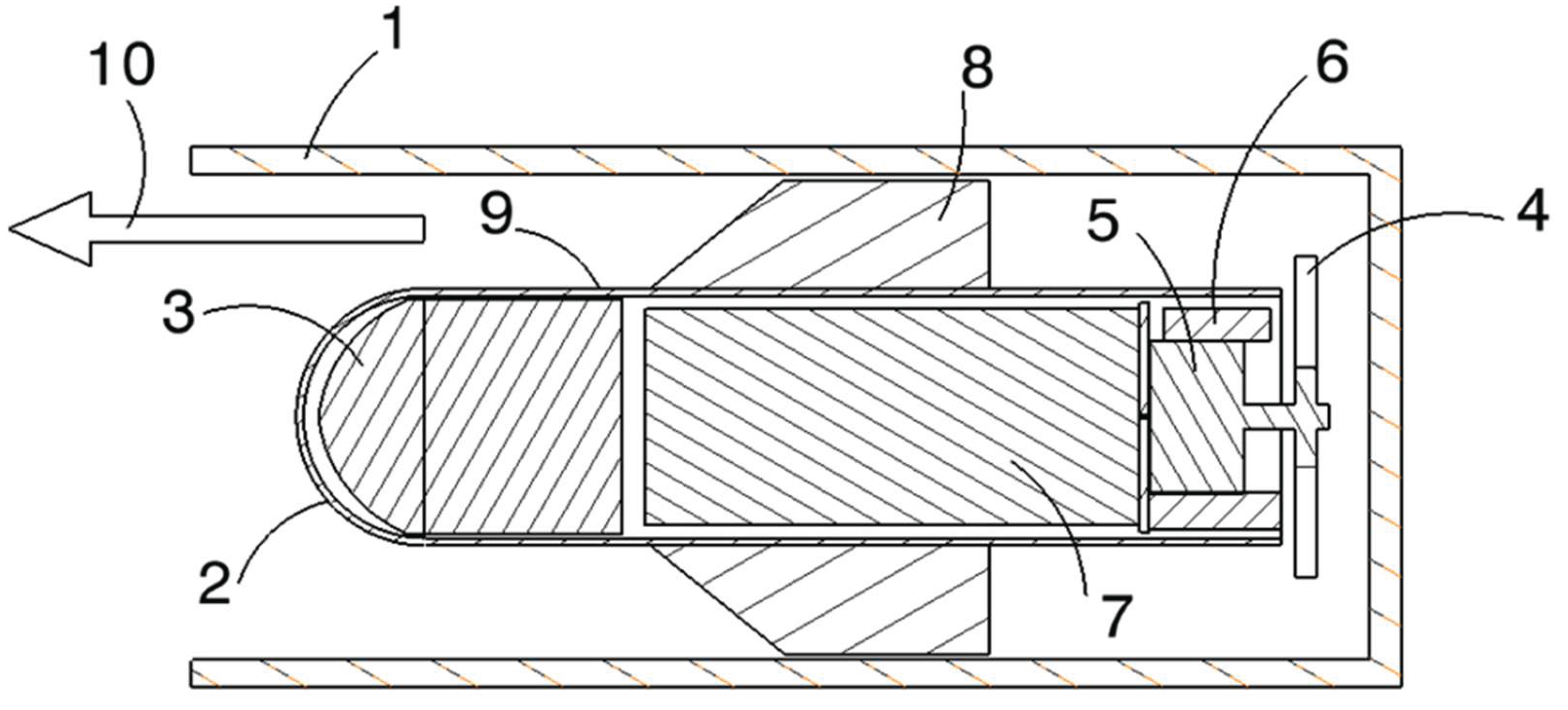
Figure 2.
Operator recognition and AI-based hazard coordination system.
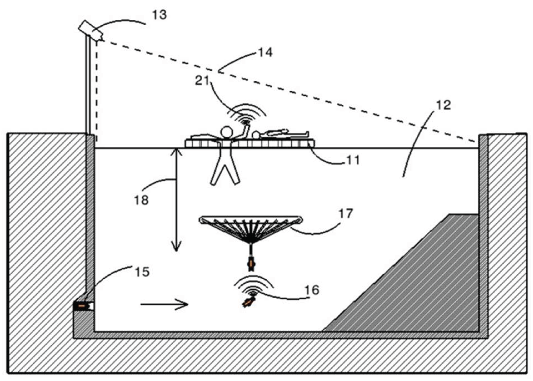
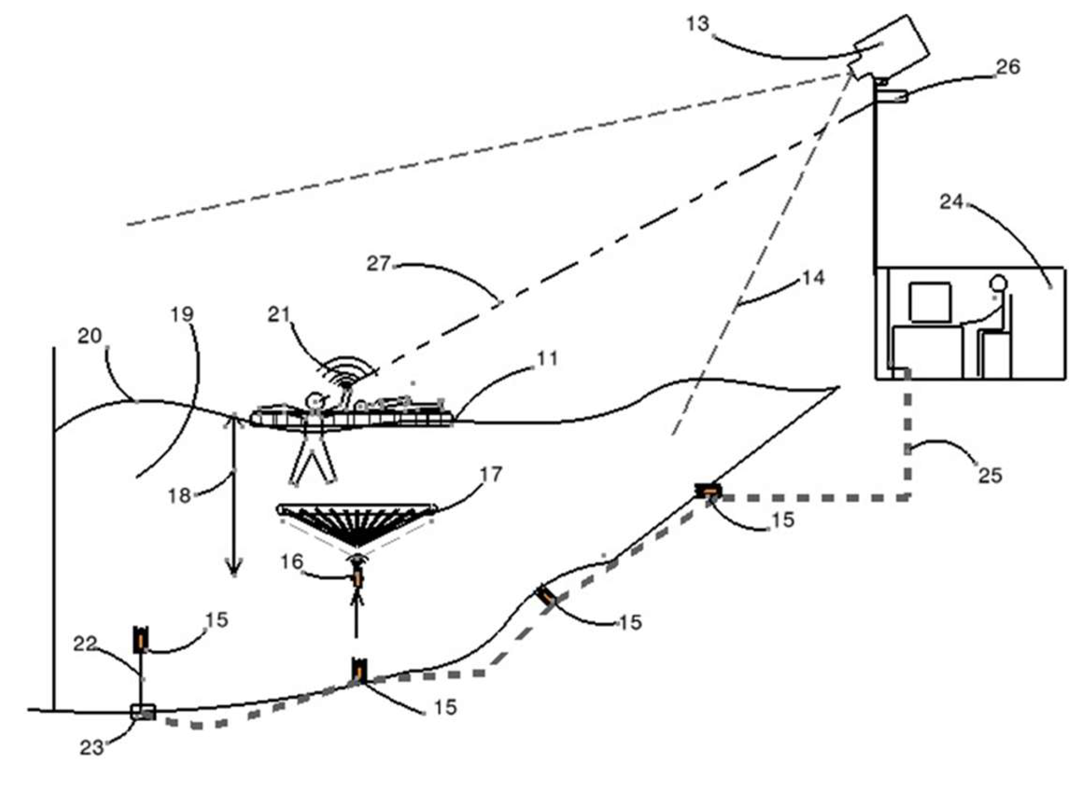
Figure 3.
Utilization of helicopters and drones for deploying lifeguard robots into the water.
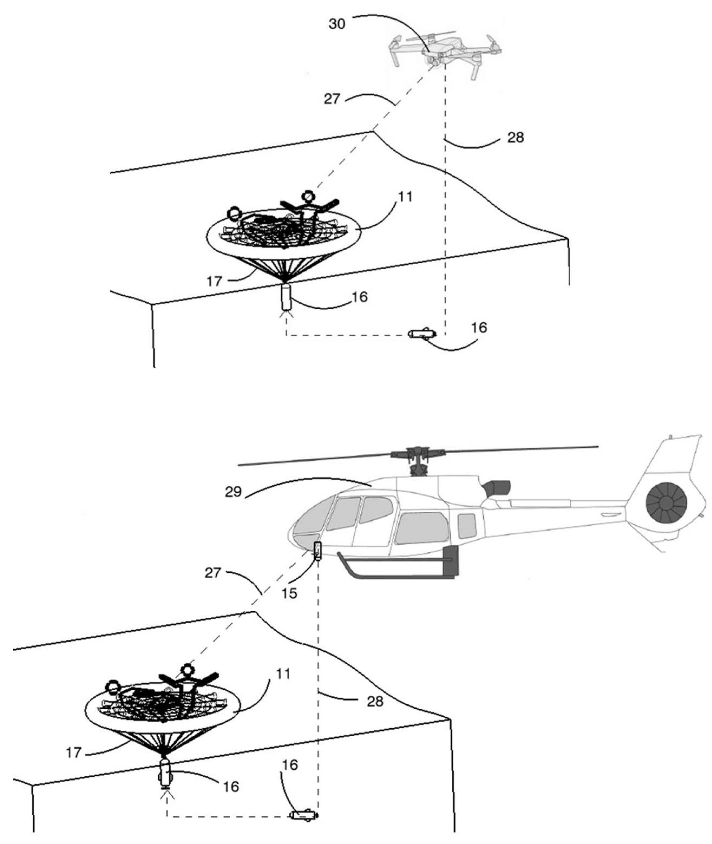
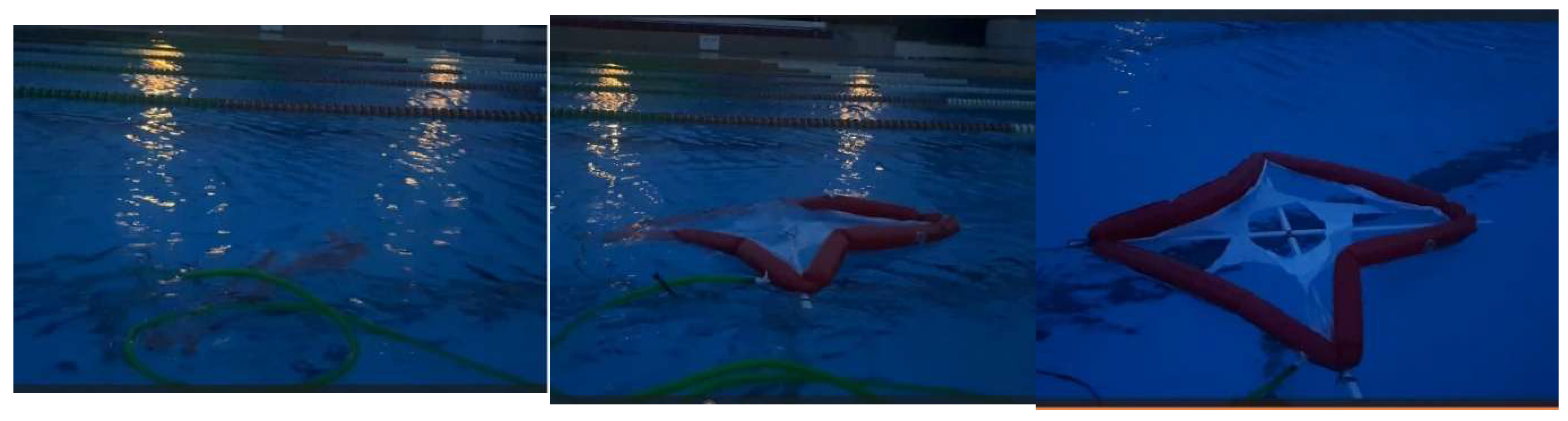
Figure 4.
The operating stages of the airbag mechanism from its placement under water to its exit from the water surface.
Figure 4.
The operating stages of the airbag mechanism from its placement under water to its exit from the water surface.
References
- World Health Organization. (2023). Global Report on Drowning Prevention: 2023 Update. Geneva: WHO Press.
- Szpilman, D.; Bierens, J. J. , Handley, A. J., & Orlowski, J. P. Drowning. New England Journal of Medicine 2012, 366, 2102–2110. [Google Scholar]
- Peden, A. E. , Franklin, R. C., & Leggat, P. A. The hidden tragedy of rivers: A decade of unintentional fatal drowning in Australia. PLoS ONE 2016, 11, e0160709. [Google Scholar]
- Moran, K.; Quan, L.; Franklin, R.; Bennett, E. Where the evidence and expert opinion meet: A review of open-water recreational safety messages. International Journal of Aquatic Research and Education 2011, 5, 251–270. [Google Scholar] [CrossRef]
- Antonelli, G.; Chiaverini, S.; Sarkar, N.; West, M. Adaptive control of an autonomous underwater vehicle: Experimental results on ODIN. IEEE Transactions on Control Systems Technology 2001, 9, 756–765. [Google Scholar] [CrossRef]
- Yuh, J.; Marani, G.; Blidberg, D.R. Applications of marine robotic vehicles. Intelligent Service Robotics 2011, 4, 221–231. [Google Scholar] [CrossRef]
- Paull, L.; Saeedi, S.; Seto, M.; Li, H. AUV navigation and localization: A review. IEEE Journal of Oceanic Engineering 2014, 39, 131–149. [Google Scholar] [CrossRef]
- Stutters, L.; Liu, H.; Tiltman, C.; Brown, D.J. Navigation technologies for autonomous underwater vehicles. IEEE Transactions on Systems, Man, and Cybernetics, Part C 2008, 38, 581–589. [Google Scholar] [CrossRef]
- Kinsey, J. C. , Eustice, R. M., & Whitcomb, L. L. A survey of underwater vehicle navigation: Recent advances and new challenges. IFAC Conference on Manoeuvring and Control of Marine Craft 2006, 88, 1–12. [Google Scholar]
- Leonard, J. J. , & Bahr, A. Autonomous underwater vehicle navigation. Springer Handbook of Ocean Engineering 2016, 341–358. [Google Scholar]
- Mallios, A.; Ridao, P.; Ribas, D.; Maurelli, F.; Petillot, Y. EKF-SLAM for AUV navigation under probabilistic sonar scan matching. IEEE/RSJ International Conference on Intelligent Robots and Systems 2010, 4404–4411. [Google Scholar]
- Burguera, A.; González, Y.; Oliver, G. Sonar sensor models and their application to mobile robot localization. Sensors 2009, 9, 10217–10243. [Google Scholar] [CrossRef]
- Krupinski, S.; Allibert, G.; Hua, M. D. , & Hamel, T. An inertial-aided homography-based visual servo control approach for autonomous underwater vehicles. IEEE Transactions on Robotics 2017, 33, 1041–1060. [Google Scholar]
- Li, J. H. , Lee, P. M., & Jun, B. H. Designs of an inertial measurement unit for an underwater vehicle and its application. International Journal of Control, Automation and Systems 2008, 6, 882–889. [Google Scholar]
- Morgado, M.; Oliveira, P.; Silvestre, C.; Vasconcelos, J.F. Embedded vehicle dynamics aiding for USBL/INS underwater navigation system. IEEE Transactions on Control Systems Technology 2013, 22, 322–330. [Google Scholar] [CrossRef]
- Ferreira, B.; Matos, A.; Cruz, N. Optimal positioning of autonomous marine vehicles for underwater acoustic source localization using TOA measurements. IEEE Underwater Communications and Networking Conference 2015, 1–5. [Google Scholar]
- Vasilescu, I.; Detweiler, C.; Rus, D. AquaNodes: An underwater sensor network. ACM Workshop on Wireless Sensor Networks for Ambient Intelligence 2010, 85–88. [Google Scholar]
- Heidemann, J.; Stojanovic, M.; Zorzi, M. Underwater sensor networks: Applications, advances and challenges. Philosophical Transactions of the Royal Society A 2012, 370, 158–175. [Google Scholar] [CrossRef]
- Eng, H. L. , Toh, K. A., Yau, W. Y., & Wang, J. DEWS: A live visual surveillance system for early drowning detection at pool. IEEE Transactions on Circuits and Systems for Video Technology 2008, 18, 196–210. [Google Scholar]
- Kharrat, M.; Wakuda, Y.; Elmoufid, H.; Uchiyama, H. Drowning detection system using computer vision techniques for indoor swimming pools. Pattern Recognition and Image Analysis 2020, 30, 513–524. [Google Scholar]
- Gochoo, M.; Tan, T. H. , Liu, S. H., Jean, F. R., Alnajjar, F. S., & Huang, S. C. Unobtrusive activity recognition of elderly people using anonymous binary sensors and DCNN. IEEE Journal of Biomedical and Health Informatics 2019, 23, 693–702. [Google Scholar]
- Luna-Perejón, F.; Montes-Sánchez, J. M. , Durán-López, L., Vazquez-Baeza, A. , Beasley-Bohórquez, I., & Sevillano-Ramos, J. L. IoT device for sitting posture classification using artificial neural networks. Electronics 2021, 10, 1825. [Google Scholar]
- Bierens, J. J. , Abelairas-Gomez, C. , Barcala Furelos, R., Causape, A. I., Cortés Colomé, A., & Crespo, A. M. Resuscitation and emergency care in drowning: A scoping review. Resuscitation 2016, 103, 25–32. [Google Scholar]
- Quan, L.; Moran, K.; Bennett, E.; Bierens, J.J. Prevention of drowning in children and adolescents: Evidence-based recommendations. Pediatrics 2015, 143, e20190850. [Google Scholar]
- Franklin, R. C. , & Pearn, J. H. Drowning for love: The aquatic victim-instead-of-rescuer syndrome. Journal of Paediatrics and Child Health 2011, 47, 44–50. [Google Scholar]
- Scarr, J. P. , & Wilkinson, D. A. Lifeguard effectiveness: A report of the 2012 lifeguard effectiveness study. International Journal of Aquatic Research and Education 2013, 7, 6–8. [Google Scholar]
- Griffiths, T.; Watts, R.; Fernandez, E.; Hunt, O.; Page, M.J. Drowning prevention: Does position of lifeguards affect their response time? International Journal of Injury Control and Safety Promotion 2018, 25, 445–449. [Google Scholar]
- Hunsucker, J. L. , & Davison, S. The effectiveness of lifeguard surveillance and the associated drowning risk in swimming pools. International Journal of Aquatic Research and Education 2016, 10, 1–12. [Google Scholar]
Disclaimer/Publisher’s Note: The statements, opinions and data contained in all publications are solely those of the individual author(s) and contributor(s) and not of MDPI and/or the editor(s). MDPI and/or the editor(s) disclaim responsibility for any injury to people or property resulting from any ideas, methods, instructions or products referred to in the content. |
© 2025 by the authors. Licensee MDPI, Basel, Switzerland. This article is an open access article distributed under the terms and conditions of the Creative Commons Attribution (CC BY) license (http://creativecommons.org/licenses/by/4.0/).
Copyright: This open access article is published under a Creative Commons CC BY 4.0 license, which permit the free download, distribution, and reuse, provided that the author and preprint are cited in any reuse.


