
Submitted:
29 September 2025
Posted:
01 October 2025
You are already at the latest version
Abstract
Lidar measurements of green laser light traveling inside snow can be modeled using Monte Carlo simulations. These simulations generate databases that link snow properties (such as depth and scattering mean free path) with lidar backscatter vertical profile measurements. In this study, such simulated data is used to train neural networks that can be applied to ICESat-2 lidar measurements. The networks are trained with simulated backscatter profiles as inputs and snow properties as outputs. Our results demonstrate that machine learning methods can accurately retrieve snow properties from lidar measurements, even when using only the near-surface portion of the snow backscatter signal.
Keywords:
snow septh
; Space Lidar
; ICESat-2
; Monte Carlo
; neural networks
1. Introduction
Snowpack, the accumulation of snow on the ground, is crucial for water resources, ecosystem health, and recreational activities [1,2]. It acts as a natural reservoir, gradually releasing meltwater, which is vital for human consumption, agriculture, and hydropower generation [3]. In addition, snowpack plays a critical role in regulating climate, moderating soil temperature, and influencing wildfire risk [4,5,6].
Measurements of snow depth and snow density are key to estimating the amount of snowpack. NASA Langley team has developed a method to estimate snow depth using lidar measurements from NASA's Ice, Cloud, and land Elevation Satellite-2 (ICESat-2) mission [7,8,9]. This method is based on analyzing the photon multiple scattering pathlength distribution within the snowpack, which is related to how far photons travel within the snow before being scattered back to the lidar. A key finding is that, at a conservative scattering wavelength, the average photon pathlength inside the snow is approximately twice the physical snow depth. The finding is derived from Monte Carlo simulations of light scattering by snow particles under a wide range of physical and optical conditions, including snow depth, snow density, volume-to-surface ratio (also called effective grain size), and single scattering asymmetry factor [7,8]. For space-based lidar (e.g., ICESat-2) measurements with the receiver footprint at least a few meters larger than the laser spot, the Monte Carlo simulation results suggest that:
- The photon multiple scattering pathlength distribution is primarily determined by snow depth and the effective scattering mean-free-path, <p>, which is a function of snow density, effective single scattering asymmetry factor, and snow particle volume-to-surface-area ratio (commonly referred to as “grain size”).
- The averaged pathlength of the photon multiple scattering pathlength distribution, <L>, equals twice the physical snow depth.
Using the theory, snow depths can be derived from the satellite lidar measurements of the pathlength distributions of green laser photons scattering inside the snow (Figure 1 and Figure 2) [7,8,9]. While the snow depths derived from ICESat-2 generally compare well against other measurements [9], there remains room for improvement because ICESat-2 was not specifically designed for optimized scattering pathlength measurements. This study therefore aims to: (1) develop a data analysis algorithm that can quickly produce accurate snow depths from imperfect measurements, and (2) explore approaches to make affordable and accurate snow depth measurements.
2. Neural Network Algorithm
First, this study introduces a machine learning algorithm designed to mitigate errors arising from two key measurement limitations.
- Transient response of ATLAS: ICESat-2's Advanced Topographic Laser Altimeter System (ATLAS) has a transient response that affects its signals. After receiving the primary signal, the lidar system can produce secondary signals (so-called "after-pulses") that appear as additional photons, potentially misrepresenting the surface return. Traditionally, a deconvolution process [10,11,12] is required to remove this effect and recover the true scattering pathlength distribution. However, this process can introduce errors, especially for noisy lidar profiles.
- Limited photon return data: ICESat-2 was primarily designed to measure the elevation of Earth’s surface [13]. Due to limited downlink bandwidth, the satellite only sends back the time-tags of the photons that are close to the surface and ignores the long tails of the multiple scattering pathlength distribution. Although those ignored tails can be approximated from near-surface signals, the extrapolation may introduce errors in the averaged photon pathlength estimates.
This study addresses both issues using neural networks trained on dataset generated by Monte Carlo simulations of laser light propagation inside snow with varying snow properties (e.g., snow depths, snow grain size, snow density, and scattering phase functions). To replicate ICESat-2 observations, the ATLAS detector’s transient response, estimated from ICESat-2 hard surface measurements [11], is applied to the simulated backscatter profiles. The algorithm retrieves snow depth and the effective scattering mean-free-path, p, directly from the near surface lidar measurements. Here, p is proportional to [14,15]. D is snow grain size (effective diameter, which is proportional to the ratio of the total volume and the total surface area of all snow particles). is the normalized snow density (snow density divided by the density of ice, 0.917 g/cm3). g is the effective asymmetry factor of snow particle single scattering phase function (typically 0.75 - 0.9). In the microwave snow measurement community, the mean-free-path is also called “correlation length”.
The procedures of algorithm development include:
- Monte Carlo simulations: Simulate ICESat-2 laser light propagation inside snow for various snow depths and scattering mean-free-paths.
- Signal generation: Model ICESat-2 lidar snow multiple scatter profiles using ICESat-2 lidar aperture size, receiver optical transmittance, detector quantum efficiency, instrument transient response, and various noises.
- Neural network training: Train the neural network using randomly selected samples of the snow depths and mean-free-paths (output of the neural network), and the corresponding lidar backscattering profiles from Monte Carlo simulation (input of the neural network).
- Validation: Apply the trained network to the remaining Monte Carlo simulated lidar profiles and compare the retrieved snow depths and mean free paths with the true values used in the simulations.
3. Evaluation of the Algorithm
Light scattered within snow attenuates exponentially with distance, resulting in higher signal-to-noise ratios (SNRs) near the snow surface (Figure 2). If snow properties can be derived from the intensity of the light that traveled a short distance below the surface (of which SNRs are high), the laser power, aperture size, and overall cost of a space-based snow lidar can be reduced. Our results indicate that snow depth and mean free path can be accurately estimated from lidar pathlength distributions corresponding to round trip distances of 12 m, 20 m and 30 m (equivalent to one-way distance of 6 m, 10 m, and 15 m) within the snowpack (Figure 3 and Figure 4).
Experimentation also demonstrate that data from shallower snow can be extrapolated to data of deeper snow with some accuracy (consistently >90% of mean-free path data <2% error) (Figure 5). This finding is valuable because it indicates that the lidar does not need to collect extensive data to retrieve snow depth accurately. However, the reverse is not true: data from deeper snow cannot train the model to test shallow snow accurately.
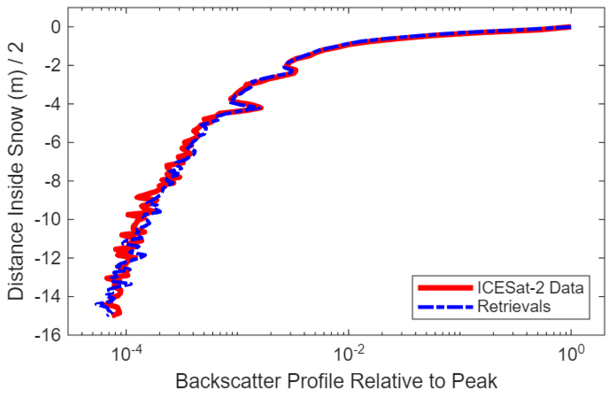
We applied the neural network algorithms (using 6 m, 10 m, 15 m lidar backscatter profiles as inputs) to the ICESat-2 measurements. In most cases, the snow depths and mean-free-paths derived from the three algorithms (using 6 m, 10 m, 15 m lidar backscatter profiles as inputs) are nearly identical (Figure 3, Figure 4 and Figure 5). Figure 6 shows the ICESat-2 lidar measurements of snow backscatter profile (red line), and the Monte Carlo simulated lidar signals using a snow depth of 0.33 m and a mean-free-path of 0.28 cm.
4. Summary
In this study, a machine learning algorithm is developed for deriving snow properties from ICESat-2 lidar measurements of multiple-scattered photon pathlength distributions within snow. The neural network was trained using Monte Carlo simulations of the lidar measurements of snow backscatter profiles for various snow depths and effective scattering mean-free-paths. When applied to ICESat-2 measurements using different vertical range bins (first 6 m, 10 m and 15 m), the snow depths and mean-free-paths derived from these neural network algorithms were consistent. Our results demonstrate that snow properties can be accurately estimated from satellite lidar data using backscatter from only the near-surface layers of the snowpack.
Author Contributions
Conceptualization, X.L.; methodology, Y.Z. and K.H.; software, Y.Z. and K.H.; validation, Y.Z. and K.H.; formal analysis, Y.Z. and K.H.; writing—original draft preparation, Y.Z. and K.H.; writing—review and editing, X.L.; supervision, X.L.; funding acquisition, X.L. All authors have read and agreed to the published version of the manuscript.
Funding
This research was funded by NASA ICESat-2 award and the NASA Terrestrial Hydrology Program, grant number 80NSSC21K0910.
Data Availability Statement
ICESat-2 lidar data product are publicly available through the National Snow and Ice Data Center (NSIDC) at https://nsidc.org/data/atl03/versions/7.
Acknowledgments
The authors thank the NASA ICESat-2 team and the National Snow and Ice Data Center (NSIDC) for providing the lidar data used in this study. Special thanks are extended to Craig Ferguson from NASA Headquarter for his support of the snow research.
Conflicts of Interest
The authors declare no conflicts of interest.
References
- Ford, C.M.; Kendall, A.D.; Hyndman, D.W. Snowpacks Decrease and Streamflows Shift across the Eastern US as Winters Warm. Sci. Total Environ. 2021, 793, 148483. [Google Scholar] [CrossRef] [PubMed]
- Simpkins, G. Snow-Related Water Woes. Nat. Clim. Change 2018, 8, 945–945. [Google Scholar] [CrossRef]
- Qin, Y.; Abatzoglou, J.T.; Siebert, S.; Huning, L.S.; AghaKouchak, A.; Mankin, J.S.; Hong, C.; Tong, D.; Davis, S.J.; Mueller, N.D. Agricultural Risks from Changing Snowmelt. Nat. Clim. Change 2020, 10, 459–465. [Google Scholar] [CrossRef]
- Clow, D.W. Changes in the Timing of Snowmelt and Streamflow in Colorado: A Response to Recent Warming. J. Clim. 2010, 23, 2293–2306. [Google Scholar] [CrossRef]
- Sanders-DeMott, R.; Campbell, J.L.; Groffman, P.M.; Rustad, L.E.; Templer, P.H. Chapter 10 - Soil Warming and Winter Snowpacks: Implications for Northern Forest Ecosystem Functioning. In Ecosystem Consequences of Soil Warming; Mohan, J.E., Ed.; Academic Press, 2019; pp. 245–278 ISBN 978-0-12-813493-1.
- Westerling, A.L.; Hidalgo, H.G.; Cayan, D.R.; Swetnam, T.W. Warming and Earlier Spring Increase Western U. S. Forest Wildfire Activity. Science 2006, 313, 940–943. [Google Scholar] [CrossRef] [PubMed]
- Hu, Y.; Lu, X.; Zeng, X.; Gatebe, C.; Fu, Q.; Yang, P.; Weimer, C.; Stamnes, S.; Baize, R.; Omar, A.; et al. Linking Lidar Multiple Scattering Profiles to Snow Depth and Snow Density: An Analytical Radiative Transfer Analysis and the Implications for Remote Sensing of Snow. Front. Remote Sens. 2023, 4. [Google Scholar] [CrossRef]
- Hu, Y.; Lu, X.; Zeng, X.; Stamnes, S.A.; Neuman, T.A.; Kurtz, N.T.; Zhai, P.; Gao, M.; Sun, W.; Xu, K.; et al. Deriving Snow Depth From ICESat-2 Lidar Multiple Scattering Measurements. Front. Remote Sens. 2022, 3. [Google Scholar] [CrossRef]
- Lu, X.; Hu, Y.; Zeng, X.; Stamnes, S.A.; Neuman, T.A.; Kurtz, N.T.; Yang, Y.; Zhai, P.-W.; Gao, M.; Sun, W.; et al. Deriving Snow Depth From ICESat-2 Lidar Multiple Scattering Measurements: Uncertainty Analyses. Front. Remote Sens. 2022, 3. [Google Scholar] [CrossRef]
- Li, J.; Hu, Y.; Huang, J.; Stamnes, K.; Yi, Y.; Stamnes, S. A New Method for Retrieval of the Extinction Coefficient of Water Clouds by Using the Tail of the CALIOP Signal. Atmos Chem Phys 2011, 11, 2903–2916. [Google Scholar] [CrossRef]
- Lu, X.; Hu, Y.; Yang, Y.; Vaughan, M.; Palm, S.; Trepte, C.; Omar, A.; Lucker, P.; Baize, R. Enabling Value Added Scientific Applications of ICESat-2 Data With Effective Removal of Afterpulses. Earth Space Sci. 2021, 8, e2021EA001729. [Google Scholar] [CrossRef] [PubMed]
- Lu, X.; Hu, Y.; Vaughan, M.; Rodier, S.; Trepte, C.; Lucker, P.; Omar, A. New Attenuated Backscatter Profile by Removing the CALIOP Receiver’s Transient Response. J. Quant. Spectrosc. Radiat. Transf. 2020, 107244. [Google Scholar] [CrossRef]
- Markus, T.; Neumann, T.; Martino, A.; Abdalati, W.; Brunt, K.; Csatho, B.; Farrell, S.; Fricker, H.; Gardner, A.; Harding, D.; et al. The Ice, Cloud, and Land Elevation Satellite-2 (ICESat-2): Science Requirements, Concept, and Implementation. Remote Sens. Environ. 2017, 190, 260–273. [Google Scholar] [CrossRef]
- Henley, C.A.; Meyer, C.R.; Chalif, J.I.; Hollmann, J.L.; Raskar, R. Measurement of Snowpack Density, Grain Size, and Black Carbon Concentration Using Time-Domain Diffuse Optics. J. Glaciol. 2025, 71, e6. [Google Scholar] [CrossRef]
- Kokhanovsky, A.A.; Zege, E.P. Scattering Optics of Snow. Appl Opt 2004, 43, 1589–1602. [Google Scholar] [CrossRef] [PubMed]
Figure 1.
blue-green sunlight bounces many times inside snow while light in other colors is reflected away or absorbed.
Figure 1.
blue-green sunlight bounces many times inside snow while light in other colors is reflected away or absorbed.
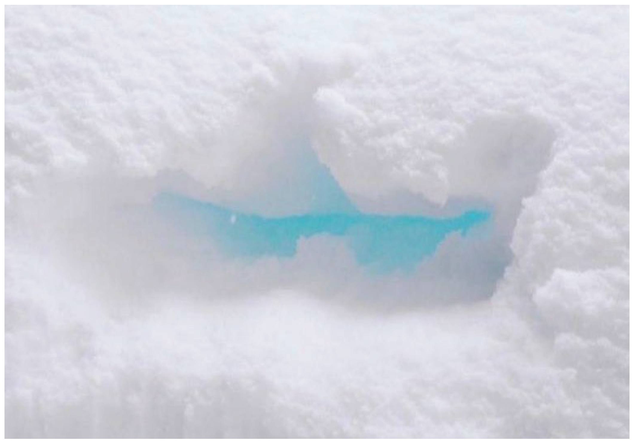
Figure 2.
An example of the lidar signals from ICESat-2 measurements.
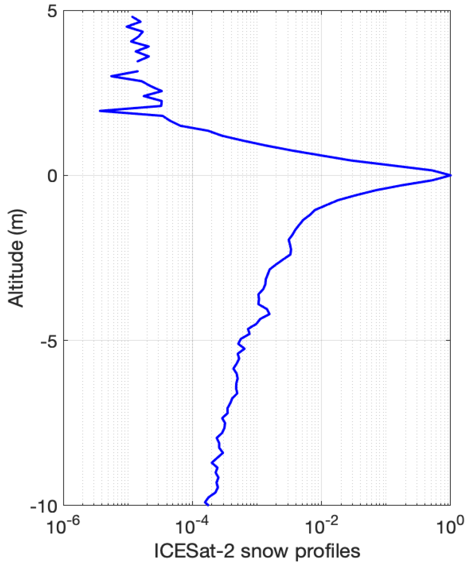
Figure 3.
Histograms of percentage error of the snow depths (a) and mean-free-path (b) with the neural network algorithms using lidar measurements of the first 15 m range bins (blue), first 10 m range bins (green) and 6 m range bins (yellow) below surface as input parameters.
Figure 3.
Histograms of percentage error of the snow depths (a) and mean-free-path (b) with the neural network algorithms using lidar measurements of the first 15 m range bins (blue), first 10 m range bins (green) and 6 m range bins (yellow) below surface as input parameters.
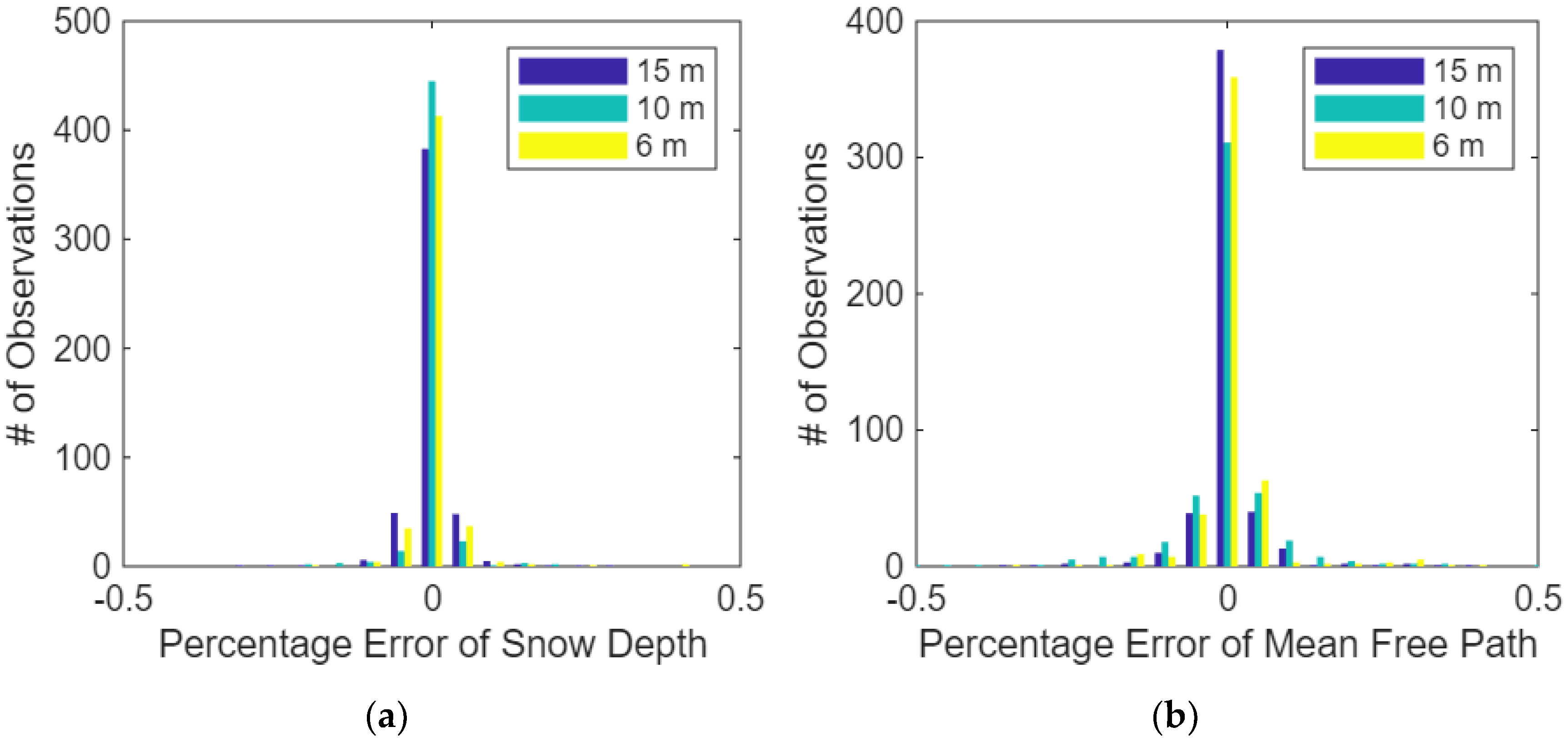
Figure 4.
Snow depth error as a function of one-way distance used for the training.
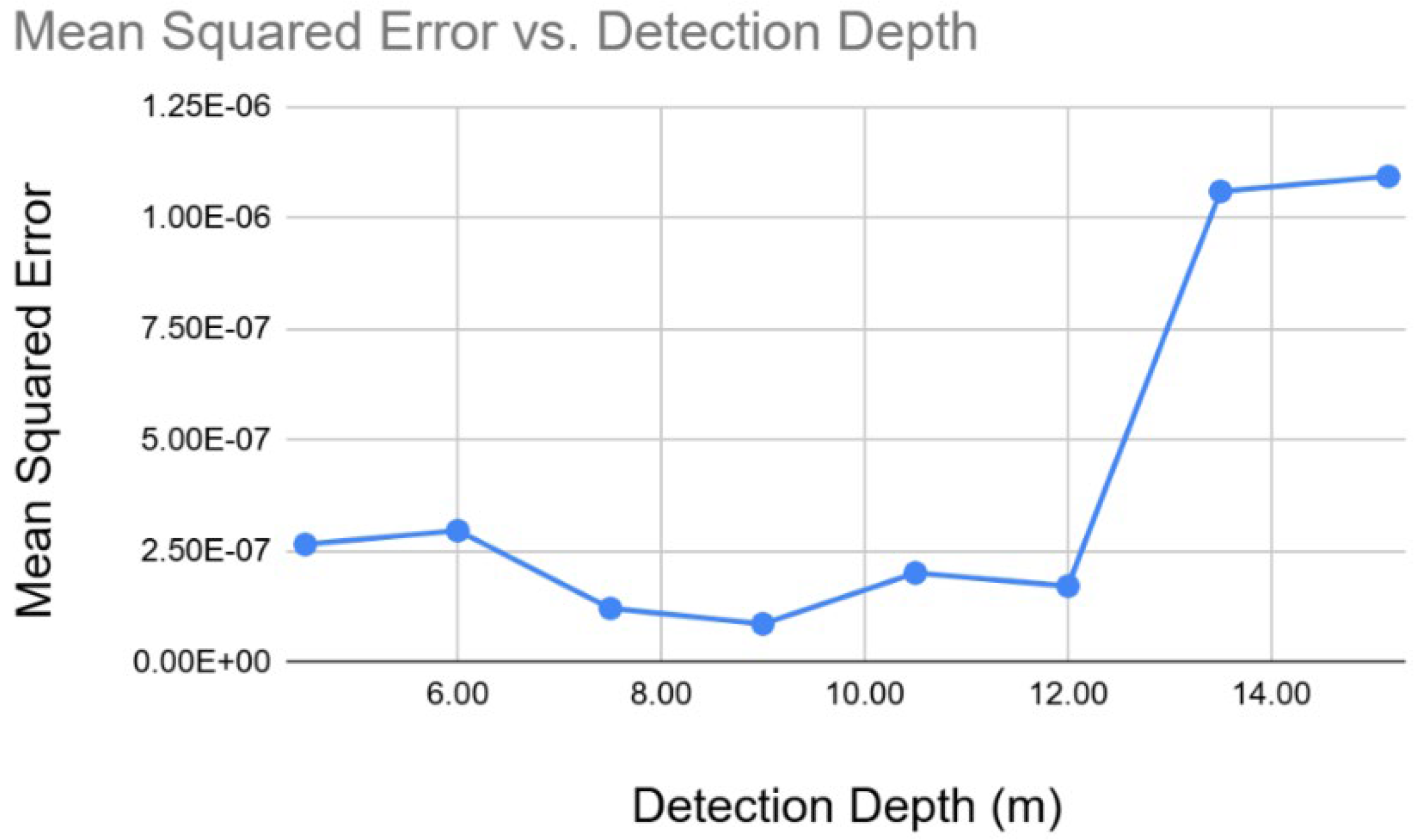
Figure 5.
Histogram of mean-free path accuracy from deeper data after shallower data training.
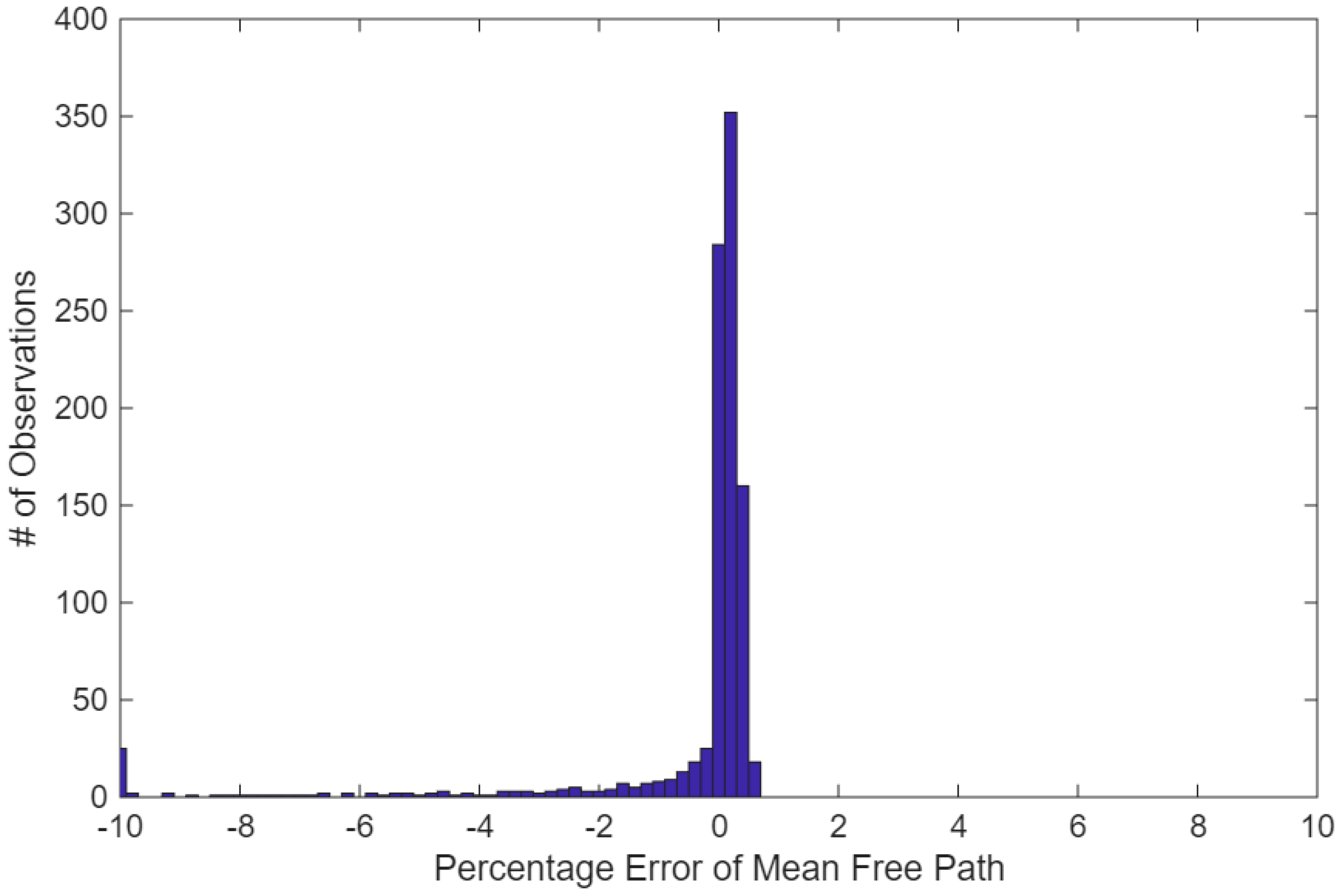
Figure 6.
Snow backscatter profile from ICESat-2 data (red), and the snow backscatter profile from Monte Carlo simulations using the snow depth (33 cm) and mean-free-path (0.28 cm) derived from the machine learning algorithm as input parameters.
Figure 6.
Snow backscatter profile from ICESat-2 data (red), and the snow backscatter profile from Monte Carlo simulations using the snow depth (33 cm) and mean-free-path (0.28 cm) derived from the machine learning algorithm as input parameters.
Disclaimer/Publisher’s Note: The statements, opinions and data contained in all publications are solely those of the individual author(s) and contributor(s) and not of MDPI and/or the editor(s). MDPI and/or the editor(s) disclaim responsibility for any injury to people or property resulting from any ideas, methods, instructions or products referred to in the content. |
© 2025 by the authors. Licensee MDPI, Basel, Switzerland. This article is an open access article distributed under the terms and conditions of the Creative Commons Attribution (CC BY) license (http://creativecommons.org/licenses/by/4.0/).
Copyright: This open access article is published under a Creative Commons CC BY 4.0 license, which permit the free download, distribution, and reuse, provided that the author and preprint are cited in any reuse.


