Submitted:
06 September 2025
Posted:
08 September 2025
You are already at the latest version
Abstract
The mountain forests of the Eastern Caucasus bear the mark of long-term interaction between nature and humans. As shown by the results of forest mapping and forest use surveys, forest cover is fragmented, and forest resource use is regulated by a combination of formal and informal rules. Over a long period of history, a close relationship has developed between the diversity of mountain forest ecosystems and the institutions that regulate the use of forest resources. The established links between the population and the forest, institutions and ecosystems are reflected in the spatial pattern of different forest types, which are subject to dynamics influenced by natural factors (mainly climatic) and changing socio-political conditions. The article presents the results of mapping and analysing changes in forest cover and its use in the Chechen Re-public from a historical perspective and, in more detail, over the last few decades. For-est regeneration dynamics are observed at the upper forest line due to reduced grazing pressure and global warming. Forest densification is also observed across the entire range of altitudinal zones. Managing mountain forests in conditions of great natural and institutional diversity requires a shift in thinking from a narrow sectoral under-standing of forest biocenoses to viewing them as mountain socio-ecological systems. Assessing the sustainability of mountain forestscapes should take into account not only ecological parameters (such as biomass quantity) but also socio-ecological relation-ships expressed in the spatial mosaic of mountain forest ecosystems embedded in the local institutional system. The authors recommend raising awareness and involving the local population in the management of forest ecosystems.
Keywords:
mountain forestscapes
; landscapes
; ecosystems
; institutions
; spatial patterns
; ecotone
; forest use
; traditional and state institutions
; land use change
1. Introduction
The key importance of mountain forests lies in ensuring the stability of mountain landscapes and ecosystems, preserving the living environment of indigenous populations, and increasing the attractiveness of mountains for tourism [1]. They ensure the stability of the entire mountain system, protecting it from erosion and reducing the risk of natural disasters (avalanches, mudslides, landslides) [2]. In addition, forests are a source of biodiversity and a resource for the local population [3,4]. Mountain forests, with their high resource potential and contribution to the sustainability of mountain ecosystems, are often at the centre of the conflict between development and nature conservation [5]. Although industrial logging in mountains has declined significantly in many mountain regions, many types of use, such as grazing in forest areas, firewood harvesting, road construction, clearing of forest areas for recreational activities, etc., are leading to a reduction in the area of mountain forests worldwide [6]. Forest fires associated with human activity contribute significantly to this.
At the beginning of this century, key trends in mountain forest research and assessment were identified, marking a shift towards integrated forest management, a reassessment of the role of mountain forests worldwide, rapid rates of forest change, and recognition of the global importance of mountain ecosystems and their inhabitants [7]. These trends are still relevant today, but the focus has shifted towards involving local communities in management, increasing the role of forests in tourism and recreation, and recognising the global importance of forests as carbon sinks. The development of methods for studying forests using remote sensing allows for more detailed measurements of the structure and dynamics of mountain forest ecosystems, which increases the accuracy of assessing the contribution of mountain forests to the sustainability of mountain ecosystems.
Understanding the dynamics of mountain forest ecosystems is not limited to studying natural processes such as bioproductivity, biodiversity, etc., but also includes the role of human activity in forest sustainability. Mountain forests have developed through a long process of co-evolution between humans and mountain nature, forming a unique humans and forests symbiosis. The visible natural appearance often conceals layers of historical periods of forest degradation and regeneration [8]. Socio-economic factors influence the sustainability of local mountain ecosystems and lead to significant changes in mountain landscapes [9]. Human influence over thousands of years has shaped the mountain vegetation of the Alps and continues to have a significant impact on contemporary species composition and distribution [10]. The academic knowledge accumulated to date only partially reveals the problems of the co-evolution of humans and mountains. Issues of mountain forest management, taking into account their self-regenerating functions and the role of science, local communities and the state, remain crucial for optimising forest use and increasing their sustainability. There is a gap between academic knowledge and local practice [11].
This article presents the results of research of mountain forest landscapes and their current and historical use in the North-Eastern Caucasus within the Chechen Republic. Mountain forests here are highly diverse, due to both natural conditions and long-term use. The aim of the study is to assess the contribution of natural and social factors to the existing spatial structure and dynamics of mountain forest landscapes. Two sets of tasks will be addressed. One group involves mapping the diversity of mountain forest ecosystems in the mountainous part of the Chechen Republic and assessing their productivity, biodiversity and dynamics. Another involves analyzing the use of mountain forest ecosystems with an emphasis on rules that are based on formal state and informal traditional institutions. The hypothesis is that over a long period of forest use, a system of relationships has developed between the diversity of mountain ecosystems and the institutions that regulate forest use. The diversity of mountain forest ecosystems influences the nature of use and the associated institutional diversity. On the other hand, external socio-political factors can have a dramatic impact on local institutions and thus lead to changes in the use of forest resources. An interdisciplinary analysis of the environmental and social factors affecting the current state and spatial mosaic of mountain forest ecosystems and the institutions responsible for forest use and management is important for developing recommendations to improve the sustainability of mountain forests in the study area.
2. Theoretical Framework
Mountainous areas with a mosaic of ecosystem cover and layers of different developmental stages, combined with formal and informal practices, can create an impression of anarchy, which must be understood to identify patterns of order [12]. Reducing the level of complexity and understanding the causes of various transformations of forest cover in the mountains should involve, on the one hand, researching the spatial patterns of mountain forest ecosystems and, on the other hand, identifying links with institutions.
Spatial patterns
The study of spatial patterns involves identifying and analysing boundaries of various kinds, primarily ecological ones between different types of ecosystems, as well as social ones reflecting different actors and types of use. This can lead to the formation of special mountain linescapes [13]. A fundamental characteristic of mountains is the altitudinal zonation of ecosystems. The mountain forest belt is interconnected with the lower and upper belts through flows of matter and energy. This is especially important in temperate latitudes with diverse altitude zones. Mountain forest management must take into account the functional links between mountain forests and surrounding ecosystems, mountain populations with their culture and institutions, and inhabitants of the foothills and plains. Altitudinal and exposure contrasts, changing hydrothermal conditions, and the stratification of historical periods of use have determined an important feature of mountain forest ecosystems: the formation of relatively broad transition zones between altitudinal zones and between ecosystems with varying degrees of anthropogenic transformation. A classic transition zone (ecotone) is the upper forest boundary, which, as studies have shown, depends not only on the mountain climate but also on human use [14]. Mountain forests in temperate zones, which have also been subjected to long-term anthropogenic impact, often represent a mosaic of forest areas and ecotones [15]. As a result of grazing over thousands of years, humans have formed an ecotone of forest and meadow in the mountains [16,17]. Mountain forests are often anthropogenic modifications, and purely natural forest cores are extremely rare even in the mountains. In Europe, the Carpathian Mountains are often considered to be conditionally natural mountain forests, and the renaturation of European forests became most apparent after the Second World War [18]. The cores of natural forests in the Urals are well indicated by the distribution of cedar [19]. However, secondary forests, modified to varying degrees by humans, predominate in Europe and much of Asia. These are often anthropogenic modifications and ecotones that have absorbed the altitudinal characteristics of the surrounding landscapes.
In the northern and humid mountains, long-term use of the mountains has shaped a mountain cultural landscape where livestock is used for grazing, haymaking, fuel collection and various other purposes. This has resulted in a significant increase in pasture area at the expense of forests. These semi-natural pastures and wastelands with their unique biological diversity have until recently dominated the mountains, but today their area is shrinking due to the encroachment of forests, which in turn is the result of changes in land use [20]. The phenomenon of mountain-forest ecotones should not end with ecological and landscape characteristics, but should be accompanied by an analysis of the institutional conditions and mechanisms that, together with changing natural (mainly climatic) factors, underlie the reproduction of ecotones in different historical periods.
Institutional links
Institutional diversity is highly dependent on natural conditions and resources [21]. Preserving institutional diversity maintains a range of solutions for social systems adapted to various ecological contexts [22]. The relationship between landscape and institutional diversity is most consistently represented in the concept of the socio-ecological system [23]. The structure of a socio-ecological system consists of four parts: resource systems, resource units, governance systems and actors. As the concept developed, ecological rules related to external social conditions were added [24]. Mountains are an excellent example of socio-ecological systems where sustainability is achieved through the integration of environmental, economic and institutional factors based on the dynamics of institutional change [25]. Mountain forests, which occupy critical positions in the altitude spectrum and are subject to various anthropogenic impacts, are typical representatives of socio-ecological systems [26], the sustainability of which requires an integrated ecological and economic approach. In socio-ecological systems, institutions occupy a central place – a system of rules and procedures for decision-making between actors [27]. They are invisible but universally recognised rules that include not only economic but also cultural and ethical components. This also touches on the issue of monitoring, control and sanctions. The basis of sustainability is regulatory institutions, which often incorporate ethnological knowledge [28].
Studies of mountain forest landscapes in Europe show that the unification and construction of monotonous mountain forest ecosystems under uniform institutions—where economic aspects dominate—lead to a decrease in their resilience under the influence of climate change [29,30]. Far from their natural state, mountain forests become more susceptible to pest attacks, poorly adapted to climate change, have reduced soil fertility, and disturbed water balance, all of which diminish their resistance to erosion. The fundamental question—what is more effective: mono- or poly-actor use of forests, monopoly or diversity of institutions, diversification of forest institutions—is gradually being resolved in favor of institutional diversity. The state tends to seek the unification of institutions [31], while local communities prefer a set of institutions necessary for adapting to the complex and changing conditions of mountain life. Finding effective institutional mechanisms for forest use that align with regional specifics is one of the key interdisciplinary challenges [24]. Many mountain forests are collectively used and represent common-pool resources [32]. Monetization and other economic approaches to regulation are not always effective [33].
Thus, mountain forests are understood as an important socio-ecological system, an ecotone that is managed through a combination of informal (mainly traditional) and formal (mainly state) institutions. Within the framework of montology, forestscape is understood as the sphere of material elements and imaginaries that create the sense of place of forests, including biota and particularly trees [13]. In this definition, the concept of forest largely depends on its perception by the local population. For some peoples, the term forest often refers to sparse shrubbery, scrubland and isolated areas of forest-steppe landscapes. The transitional natural and ecological parameters of the forest are rooted in the fabric of local practices. In the Eastern Caucasus, the concept of forest has a wide range: from relatively closed forest in its typical (European) understanding to forest as a combination of meadow glades, arid sparse forests, etc.
The balance between spatial patterns and institutions regulating access to forest use is fundamental to understanding the sustainability of mountain forests. Changes in this balance must take into account both natural dynamic and institutional changes. In practice, however, a technocratic approach to identifying natural dynamic prevails. The use of remote sensing serves as an objective source of data on forest cover and its dynamics (Land Use/Land Cover Change) [34]. However, in order to identify the data obtained specifically with the forest, universal methods require verification in the field. This is especially important when studying forest ecotones that are subject to multifunctional impacts. Only detailed field studies and careful interpretation of the results obtained on changes in forest land use and forest cover transformation can reveal the multifactorial nature of changes resulting from socio-economic and biophysical processes depending on the scale and nature of land use [35,36,37].
Research in the North Caucasus has shown that formal measurements of areas are insufficient to understand transformation of mountain forestscapes; they need to be linked to the social environment and institutions [38,39,40]. This work continues these studies by deepening the analysis of symbiotic relationships in the mountain forestscapes.
3. Materials and Methods
3.1. Study Area
The Caucasus is one of the world's recognised ecological regions with high landscape and biodiversity. This region is typical in terms of forest management issues: deforestation, grazing in forests, a centralised approach to forest management without taking into account local communities, etc. The Caucasus is a large ecotone at the junction of humid and arid ecosystems, where forests have a variety of modifications. The north-eastern Caucasus is an area located between subtropical and temperate zones. Here, the dry climate of the flat semi-deserts changes to a moderately humid climate in the mountains. However, a semi-arid climate forms in the intermountain basins. Compared to the humid Western Caucasus, the forest belt in the east is fragmented, which is due not only to a lack of precipitation, but also to long-term economic activity. In the west of the North Caucasus, the population in the mountains is sparse, while the north-eastern area is densely populated. There are numerous ethnic groups here for whom the forest is an important common resource for sustaining life.
The study area covers the territory of the Chechen Republic (Figure 1). Mountainous areas include a range of altitude zones: from mountain-forest foothills and low mountains, transitioning with increasing altitude to mountain-steppe basins, mountain meadows and glacial plains. Currently, the most developed areas in the Chechen Republic are the foothill-steppe landscapes, where about 80% of the population lives. Large differences in altitude have created a variety of climatic conditions. Precipitation increases with altitude (from 300 mm on the plains to 1400-1700 mm in the mountains). In the intermountain basins, the amount of precipitation decreases to 600-700 mm.
The forest zone stretches from the foot of the mountains (300 m) to 2,200 m. As a result of economic activity, it is highly fragmented, with areas of closed forest alternating with forest-steppe and forest-meadow areas. Forest use is regulated by a combination of formal (state) and informal (traditional) rules. The state has an extensive network of forestry offices that monitor forest ecosystems, regulate sanitary felling, and limit the impact of other activities (e.g., grazing). Informal rules are represented by the so-called adats, a set of traditional rules of life [41]. According to adat, forest lands in the mountains are common resources. Their regulation is based on a system of rules and restrictions, with monitoring and sanctions carried out within the framework of local traditions, morals and ethics. In particular, it is not customary to cut down certain trees (e.g. wild pear trees). Chechen society is very conservative, structured around clans (teips) and tukhums (mountain communities), which are differentiated by geographical location. This structure remains in place today and determines the main lines of power and land ownership. The Soviet government (1917-1991) fought against the traditional way of life of the Chechens. Ultimately, the Chechens were completely deported from their homes to Central Asia and Kazakhstan (from 1944 to 1957). After returning from exile, most of the population settled in the foothills, while the mountainous areas remained uninhabited.
The Argun Historical and Architectural Museum-Reserve (AHAMR), covering 230,000 hectares of mountainous terrain in Chechnya, was selected for a more detailed study of the dynamics of mountain forestscapes. It was established in 1988 with the aim of preserving the cultural landscape, including villages abandoned in 1944, towers and other historical and cultural complexes.
3.2. Data and Methods
Given the interdisciplinary nature of the problem, the study included both qualitative and quantitative methods. Qualitative methods focused on the analysis of historical documents, interviews with decision-makers, including local forest resource users, field observations, and route notes. Quantitative methods involved mapping landscape diversity and forest dynamics, followed by geoinformation processing. First, the natural structure of the forests was identified, and the ecological characteristics of existing forest areas and ecotones were determined. Then, the ecological types of forests and their spatial modifications were compared with human activities, and the institutions responsible for regulating forest use were identified.
Two types of data were used to study the natural structure and dynamics of forests: 1) mapping of forest ecosystems and ecotones; 2) observation of changes in forest boundaries. Mapping was carried out during field expeditions in 2014-2024 at several scales: at the level of the entire region, within the AHAMR, and at the local level within the Makazhoi intermountain basin (Figure 2).
Large-scale topographic maps and satellite images of various scales were used to extrapolate field data. The most accurate picture for extrapolating field data was provided by the results of vegetation cover interpretation and classification, for which a Sentinel-2 image from 15 August 2019 was used (Figure 3). As a result of the classification, it was possible to combine data from ground field studies with the areas identified in the satellite image.
Archival materials and topographic maps from different years (late 19th century, especially maps from the Soviet period) were used to analyse changes in forest ecosystems, in comparison with modern remote sensing data, literary sources and interviews with the local population. Additional material was provided by ground photographs taken at different times from the same point, covering the same visual scene and allowing for a clear display of various changes in slope processes, land use and the state of the biota of mountain landscapes.
For quantitative analysis of changes in the area and boundaries of forestscapes, thematic products were used, created on the basis of sequentially processed Landsat Analysis Ready Data from the Global Land Analysis and Discovery Laboratory at the University of Maryland for the period from 2000 to 2020 and geoinformation modelling algorithms [42,43]. The thematic product ‘Forest Extent and Height’ was used for 2000 and 2020 [44].
To identify the institutional structure, interviews were conducted with local residents and documents, including historical ones, relating to legal rules for forest use were analysed. During the structured interviews, a series of questions were asked about the use of local resources, their scarcity, and strategies to compensate for this scarcity. A questionnaire was compiled for the mountain villages of the Makazhoi Basin, which recorded data on: 1) actors whose interests include forests, forest areas and resources, 2) key forest resources (grazing in the forest, firewood harvesting, beekeeping, wild garlic harvesting, building materials, recreation), 3) rules governing the use of the forest by various actors.
4. Results
4.1. Mountain Forestscape and Humans: Natural Boundaries and Ecotones
As a result of the interpretation of the Sentenel-2 series image, its classification in the geoinformation environment and field verification, several types of mountain forestscapes were identified that fit into the altitudinal-zonal structure and also depend on the exposure of the slopes and the degree of anthropogenic transformation (Figure 4).

Landscapes: nival-glacial – 1; mountain-meadow: 2 – subnival-alpine, 3 – subalpine, 4 – subalpine dry; mountain-forest: 5 – small-leaved and coniferous-small-leaved, 6 – broad-leaved-small-leaved, 7 – broad-leaved; mountain-forest-meadow – 8; mountain-forest-meadow-steppe: 9 – meadow-steppe, 10 – forest-steppe; mountain-steppe: 11 – typical steppe, 12 – dry steppe shrub.
The cores of relatively natural forest areas have been preserved on the relatively steep slopes of humid habitats at altitudes of 300-1200 metres above sea level. They are part of the broadleaf and broadleaf-smallleaf forest zone, which extends from the foot of the slopes to an altitude of 1,600-1,800 metres. On gentle slopes, they are represented by closed stands of Caucasian hornbeam (Carpinus betulus), Oriental beech (Fagus orientalis), Norway maple (Acer platanoides), and ash (Fraxinus excelsior), giving way to oak forests of rock oak (Quercus petraea). In the middle mountains, they occupy small areas and are often severely degraded as a result of human activity. In the lowlands, broad-leaved beech and beech-hornbeam forests were used for economic purposes. Currently, logging is prohibited. These forests are often used for recreational and sacred purposes (Figure 5).
The upper forest line (from 1,800-2,000 to 2,200-2,400 m) coincides with the upper limit of settlement. In this ecotone, which transitions from forest to meadows, small-leaved and small-leaved coniferous forests are common. Typical for them are birch small forests and crooked forests of downy birch (Betula pubescens) and silver birch (B. pendula), less often Radde's birch (B. raddeana), rowan (Sorbus aucuparia), and willows (Salix petandra, S. caprea) are typical in the undergrowth, and azalea (Rhododendron luteum) is also found. In addition, there are forests with high-mountain maple (Acer trautvetteri). Fragmentary coniferous forests of pine (Pinus kochiana) have developed, which were previously widespread but were cut down for firewood and building material.
At the junction of forest cores and summer pastures, forest-meadow communities have formed (altitude limits from 1600 (1800 m) to 2500 (2600 m). They form an extensive belt in place of small-leaved coniferous forests as a result of long-term grazing. Small groves are confined to eroded landforms and north-facing slopes, while gentler and warmer areas are occupied by meadows used for grazing. Where grazing pressure is reduced, there is an increase in forest cover due to young birch and aspen-birch forests (Figure 6).
At the junction of forest cores, settlement areas with terraced fields and hayfields, as well as fragments of year-round pastures, forest-steppe ecosystems are widespread. Long-term human activity has transformed both the soil itself as a result of ploughing, haymaking, etc., and the relief in the form of cultivated terraces. Forest-steppe complexes were formed on the site of mountain forests as a result of development. The decline in development leads to overgrowth, and as a result of succession, forest-steppe complexes begin to turn into small forests.
On the southern slopes, in the wider areas of valleys and intermountain basins, forest-steppe communities form in conditions of low moisture and abundant heat. Here, there is a combination of diverse grass-cereal steppes, wormwood-diverse grass-cereal grazed and diverse grass-fescue-beard grass dry steppes, apple-cherry trees with oak and ash trees in sparse forests, and bean-cereal-diverse grasses in ravines and valleys of temporary watercourses. Such complexes were formed at the junction of forest areas and mainly winter pastures (Figure 7). These landscapes are widely used for winter grazing, as well as for after-grass in haymaking areas and arable terraces. Human activity has led to the clearing of forests and the spread of semiarid ecosystems on the slopes of southern exposure. The lower parts of the slopes, composed of eluvium-deluvium of siltstones and argillites, are often used to create artificial agricultural terraces. Many of them are no longer used as arable land, i.e. they are not maintained and are overgrown with shrubs and forest. Here, forb-cereal, in places tall-grass, shrubby meadow steppes with rose hips and small forests of hornbeam, maple, with hawthorn in the undergrowth, less often birch-small-wooded and pine-park forests are formed on mountain-forest-meadow and meadow-steppe loamy gravelly soils with a powerful humus horizon.
Important ecological characteristics of mountain forest ecosystems are biodiversity and bioproductivity, in particular, phytomass stock. Route observations and measurements in forest cores and ecotones have shown that maximum phytomass stocks are characteristic of forest ecosystem cores in broadleaf forests (up to 360 tonnes per hectare). Here, there are several species of tree and almost no herbaceous layer. Biomass decreases as climatic conditions deteriorate and anthropogenic activity intensifies. At the upper forest boundary and in combinations of forest and meadows used for grazing, phytomass decreases tenfold (to 20-30 tonnes per hectare). Phytomass in settlement areas in forest ecotones transitioning to mountain steppes averages only a few tonnes (2-5) (Table 1).
Mountain forests are closely linked to humans, their long-term activities and settlement patterns in terms of their distribution and species composition. Within the territory of the AHAMR, there are about 400 settlements, 80% of which are located in the transition zone from forest to meadow and from meadow to steppe. In fact, only a few dozen villages are located in the forests themselves (Figure 8).
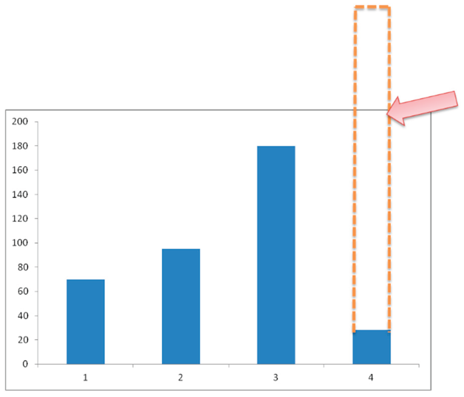
As can be seen from the graph (Figure 9), people preferred to settle in the forest-meadow-steppe and forest-steppe ecotone, as the warmest (slopes of southern exposure). Current populated areas are completely located in the forest-meadow-steppe ecotone. The current population of the plains is determined to develop the places of their ancestors. Some of the settlements are gradually beginning to be developed, mainly as seasonal dwellings.
4.2. Mountain Forestscapes and Institutions
Not only natural factors (altitudinal zonation, exposure contrasts, etc.) played an important role in the formation of the mosaic of ecotones and settlement patterns, but also the rules for the use of forests and forest-covered areas. Studies have shown that these rules changed during different historical periods. Based on the available data, three main stages of human-forest interaction in the study area can be identified, which led to the current spatial patterns of the mountain forestscapes, the ratio of the main forest modifications, and the forest-meadow and forest-steppe ecotones. These stages differ in the ratio of traditional informal and formal, largely state, institutions.
1. Until the mid-19th century, subsistence farming and extensive livestock farming dominated. The forest was a resource for common use, an important source of energy and building material. During this period, the main transitional modifications from forest to meadow and from forest to steppe were formed. The core of semi-natural forests was insignificant; according to old topographic maps, it was more than twice smaller than it is today. Forest-meadow areas were used for livestock farming, and forest-steppe areas were used for haymaking and terraced fields. The acute shortage of land suitable for arable farming was partially covered by the creation of arable terraces, forcing the development of mutual assistance mechanisms within mountain communities - tukhums [43]. As a rule, tukhums covered several dozen settlements within a small mountain valley. Within the territory of a particular tukhum, there were all three ecotones, which created the basis for livestock breeding, arable land and hayfields. As a rule, arable land and settlements were located on river terraces or on the southern slopes (forest-steppe ecotones), while the surrounding land (lower and middle slopes) was used for arable farming, hayfields and winter pastures, while the upper parts of the slopes and the summit areas were used for transhumant livestock farming. The Caucasian War, annexation by Russia, and a shortage of land amid population growth, which caused waves of migration to the plains as early as the 17th and 18th centuries, prevented the mountain communities of Chechnya from continuing to exist in relative isolation (Table 2).

Table 2.
Major actors, key forest resources and institutions regulating resource use and actor relationships in the period up to the mid-19th century.
Table 2.
Major actors, key forest resources and institutions regulating resource use and actor relationships in the period up to the mid-19th century.
| Period | Actors | Key resources | Institutions |
|---|---|---|---|
| Until the mid-19th century | The local community, represented by family-clan and tukhums | Firewood, building materials, forest products, hunting – everything for natural farming | Adat |
| Mid-19th century – 1944 | The local community, represented by family-clan and tukhums, the state | Firewood, building materials, forest products, hunting for natural farming, timber | Adat, state forest management |
| From 1944 to the early 1990s | The state, collective and state farms located on the plain, forestry enterprises, protected areas | Firewood for residents of the foothills, building materials, local forest products, beekeeping | State forest management, environmental legislation, adat |
| Since the 2000s | The state, teips, private entrepreneurs | recreation, spiritual and sacred space, local forest products, beekeeping | State forest management, adat, state development programmes |
2. From the mid-19th century to 1944, extensive semi-subsistence farming with elements of involvement in local markets prevailed. Improved transport accessibility led to the intensification of agriculture on arable terraces and the expansion of development in remote areas. The mountain population grew and began to migrate to the foothills and plains. As a result of the Caucasian War, part of the population moved to the plains and even emigrated to other countries, primarily Turkey, for religious reasons. Population growth in the foothills led to increased exploitation of forests, which were almost completely cleared in the foothills and some low-mountain areas. The state is trying to regulate forest use, and conflicts over access to forests are arising.
This period is generally characterised by a decrease in the share of subsistence farming and an increase in the share of manufactured products sold on local markets. This is due to the integration of Chechnya into Russia, which was accompanied by an increase in trade with the foothills, the beginning of industrialisation and the attraction of labour from the mountains for the construction of roads, oil facilities, etc. Agricultural development began to expand at the expense of deforested areas. It was during this period that forests became the target of logging operations, and a need for construction materials arose.
The fundamental institutional changes during the Soviet period only partially affected land use in the mountains, and the clan structure of Chechen society continued to dominate everyday life. Despite the formal declaration of state ownership of land and attempts in the 1930s to introduce village councils and, on their basis, collective farms, land use in the mountains continued to be regulated according to adat rules. In 1944, the Chechens were deported to Central Asia and Kazakhstan. Upon their return in the late 1950s, most Chechens settled in the plains and foothills. The highlands remained uninhabited until the late 1980s.
Figure 10.
Distribution of settlements in the present-day Chechen Republic by altitude zones: 1 – plains with semi-desert steppe landscapes (up to 100 m above sea level); 2 – foothills, steppe and forest-steppe landscapes (100-300 m); 3 – lowlands and midlands, predominantly forested (300-1500 m); 4 – highlands, forest-meadow, forest-meadow-steppe, forest-steppe (1500-2400). The arrow indicates several hundred settlements abandoned after 1944.
3. During the third period (from 1944 to the present), the mountainous areas served as pastures for livestock brought in from the plains. The intensification of transhumance livestock farming is taking place in the absence of a local population and the predominance of the collective farming system of kolkhozy and sovkhozy. The establishment of the AHAMR in 1988 led to the regulation of land use, and cultural objects such as stone towers were taken under protection. Between 1992 and 2009, Chechnya was in the midst of military operations, transhumance ceased, and forest areas were restored in all ecotones. As a result of forest encroachment, the area of the forest-steppe ecotone decreased and part of the cultivated terraces were destroyed.
Fundamental changes in state-legal relations and institutions after the 1990s led to the demonopolisation of state rights to land, the growth of the role of local self-government, and the development of market relations. Land privatisation mainly affected only flat lands. However, mountainous areas were also assessed, and lease relations began to develop for pasture lands, including small-forest (forest-steppe and forest-steppe) areas not included in the state forest.
The spontaneous process of gradual settlement of mountainous areas that began in recent years, initially only for the summer and then for year-round residence, is supported by the republican authorities. By decision of the Chechen Republic government, the Galanchozhsky and Cheberloevsky mountain administrative districts, which had been abolished after the deportation, were restored. The mountain territories ceased to be merely a ‘museum’ with abandoned old villages and towers, and began to be viewed as a potential space for life.
Thus, over the past century, forest use has changed in close connection with institutions: from traditional institutions in the first stage to the gradual introduction of formal state institutions in the second. However, in the third, modern stage, traditional institutions are still involved in regulating use of land in forest ecotones – forest-meadow and forest-steppe. The core of the forest is de jure under the auspices of state institutions. In recent decades, when the importance of local tourism was recognised (this became particularly pronounced during the COVID years), the protection of forestscapes has intensified. Given the shortage of sawn timber, forest areas have not become a source for the forestry business. One of the reasons for this is that sawing trees often led to the breakdown of expensive machinery due to the presence of shrapnel and bullets from the military actions of the 1990s in the wood.
The local community, with its family-clan social structure, is also involved in the day-to-day management and use of forest resources. An important source of additional income for the local population is the harvesting of wild garlic in the forests. In February and March, local entrepreneurs go into the forest to collect wild garlic, which they then resell not only to local markets, but also to markets in Central Russia, including Moscow. Another lucrative source of income is beekeeping. Places for apiaries are allocated in advance, and there is fierce competition for the most profitable locations.
4.3. Current Dynamics of Mountain Forestscapes
Since the mid-1980s, there has been a significant trend of increasing average annual temperatures, mainly due to summer temperatures: the increase in summer air temperature in high mountain areas between 1980 and 2015 was 0.3–0.4°C/10 years, and in mid-mountain areas 0.5–0.6/10 years [45]. The trend towards an expansion of forestscapes has been identified based on an analysis of satellite imagery of the mountainous regions of the Eastern Caucasus [38] and during field studies [43]. There has been a decrease in the nival-glacial zone, with mountain meadows advancing into the areas of snowfields and glaciers and mountain forests advancing into the areas of mountain meadows (Table 3). As shown by the results of a comparison of images taken at different times, changes in forest areas in the North Caucasus above 2000 m are expressed in multidirectional trends. Forest growth has been observed on an area of about 40,000 hectares, while a reduction has been observed on 14,000 hectares (Table 3). This ratio (two-thirds growth and one-third reduction) is characteristic of the eastern part of the North Caucasus as a whole. For the territory under study, the growth amounted to 314 hectares, and the decrease to 171 hectares.
Growth has been observed in areas adjacent to mountain villages, which can be explained by the transition from traditional (wood) to modern (gas) energy supplies. Areas of nearby arable land adjacent to villages (including man-made terraces) have also been abandoned and overgrown, which indicates deeper causes than energy supply. The reduction in forest areas is associated with deforestation due to road construction, the construction of communications (gas supply, electricity supply, mobile communications) and tourism infrastructure.
The dynamics of the forest should be considered in conjunction with its use. While in 2014 the priorities for use were grazing with local recreation, in 2024 tourism and recreation took first place, with grazing taking a back seat. The forest has grown by tens of metres, and the Caucasian pine forest areas have become more closed. The state has begun to support recreation, and forest protection has become stricter, with a complete ban on logging and grazing within the forest boundaries (Figure 11).
- Mountain forestscapes of the Makazhoi intermountain basin
Complex changes in mountain forestscapes are evident at the local level within historically developed areas, such as intermountain basins [40]. The Makazhoi intermountain basin is located in the eastern part of AHAMR on the border between Chechnya and Dagestan. The elevation difference in the study area reaches almost 1,500 metres (1,300-2,806). Altitudinal zonation is complicated by exposure contrasts and the influence of long-term human activity. In simplified form, the distribution of vegetation types can be represented on a two-dimensional model: exposure is plotted horizontally (from the most shaded to the most sunny), and altitude above sea level is plotted vertically. The vertical axis reflects the decrease in heat with altitude and the increase in precipitation, while the horizontal axis reflects the increase in heat and decrease in precipitation (Figure 12 and Figure 13).
The lower slopes of mountains with relatively low anthropogenic pressure are occupied by mountain forestscapes, represented by small-leaved coniferous and broad-leaved types. Increased anthropogenic pressure leads to the disappearance of forests, which are replaced by mountain forest-steppe ecotone, and these, in turn, by mountain steppe ecotone, mainly on south-facing slopes. Long-term grazing has lowered the upper forest line, leading to the formation of a mountain forest-meadow zone and, in some cases (on north-facing slopes), to the penetration of the subalpine belt of the mountain meadow zone into the mountain forest zone.
Table 4.
Key actors and land use at different historical stages.
| Ecotones (see Figure 12) |
Until the mid-19th century | From the mid-19th century to 1944 | 1944-1991 | From the 2000s to the present day |
|---|---|---|---|---|
| 1 | Family, teip. Settlements, winter pastures | Collective use of pasture | Winter pastures in actual use by families, teips. Settlements | |
| 2-3 | Family, tape. Settlements, arable land, hay-fields |
De facto: family, tape, private owner-ship. Settlements, arable land, hayfields, recreation | ||
| 4 | Collectively used pastures, all-season | |||
| 5-6 | Common use forests | state forests | ||
| 7 | Family, tape. Settlements, hayfields, pastures |
Collectively used pastures | De facto: family, tape. Settlements, hay-fields, pastures, rec-reation |
|
| 8-9 | Collectively used pastures, mainly summer pastures | |||
Until the mid-19th century, forests were used within the framework of traditional institutions, but after the Caucasian War, forests became state property with strict restrictions on their use. High-altitude pastures were and remain in collective use. Throughout history, grazing rights and regulations on access to use have changed: adat, leasehold relations, Soviet collective use, transhumance [46]. Pastures still have the status of agricultural land, which is not subject to privatisation.
The most valuable lands of forest-steppes and forest-meadow areas were managed by traditional family and clan institutions. Today, they remain de facto under the control of family and clan institutions. Although de jure they belong to local municipalities, i.e. they are collective. Currently, some Chechens have begun to return from the plains and cities to the mountains, privatising plots of land for houses and gardens. It is noteworthy that the purchase of such plots is strictly limited to those who do not belong to local teips.
The reduction in grazing intensity has led to the pastures becoming overgrown with pine and birch trees. Pine seedlings (Pinus Sosnovskyi) have been recorded on the northern slopes (Figure 14). The appearance of young pines and their upward movement along the slope is associated with both the weakening of human impact and climate warming. As shown by data from images and maps taken at different times, as well as field studies, active forest regrowth occurred in the late 1990s (cessation of use due to military operations in the area). Individual pine trees are found at an altitude of about 2,400 metres.
Thus, as research has shown, mountain forestscapes in the North-Eastern Caucasus are undergoing major changes. The forest is advancing up the slopes, overgrowing cultivated terraces and Chechen settlements. This is caused not so much by climate change as by changes in institutions, which in turn have led to socio-economic changes. State support for development has led local communities to radically change their energy sources. Gas has been brought to almost all high-altitude villages, eliminating the need to harvest firewood in the forests. The system of transhumance and pastoral livestock farming has declined significantly due to the fact that large livestock companies based in the plains and foothills, which rely on stall feeding, have led to dumping of livestock products. Only a small number of mountain dwellers still keep livestock, as it is cheaper to buy livestock products. However, with the development of tourism and the growing popularity of organic products, local production of meat, milk and other products has begun to revive. The return of Chechens to the mountains gives hope that the cultural landscapes represented by pastures, terraced fields and towers will not be completely destroyed.
5. Discussion
The mountain forestscapes of the North-Eastern Caucasus are socio-ecological systems whose structure and dynamics are influenced by both natural and social factors. The boundaries between mountain forestscapes and surrounding landscapes are unclear, due to both natural and institutional factors. There are semi-natural forests cores in which the type and structure are close to natural stages of succession. Relatively stable modifications form around these cores – combinations of forest and meadow, forest and steppe. Such combinations were formed under the influence of various human activities, primarily grazing, haymaking and ploughing. In turn, the set of land use types is closely linked to institutional conditions, the balance between traditional informal rules and state regulations. Throughout history, the ratio of forest use rules has changed: from purely traditional ones, dictated by the need to survive in harsh conditions of land scarcity and energy shortages, to state ones, which have a monopoly on access to forest resources.
The history of forest use has seen two extreme attitudes towards forests. In the first case, forests were degraded as a result of logging for firewood and timber for construction, and grazing livestock in the forest. The upper forest line receded, and forest-meadow and forest-steppe ecotones expanded. The heavy burden on forest landscapes caused by population growth and fuel demand led to the destruction of forest cover and the spread of landslides and mudslides. Massive landslides repeatedly led to the migration of Chechen villagers to the plains. A different attitude has been observed since the second half of the 20th century and continues to this day. Since 1944, the Chechen population has been sparse in the mountains. The forest began to recover, mainly in the form of small trees and shrubbery. A side effect of this type of land use was the spread of azalea, which was not eaten by livestock and took large areas of pasture out of use. Combating the spread of azalea was one of the most important land improvement measures.
Currently, the result of historical stages of use of varying intensity and nature is a complex picture of the relationship between different types of mountain forest ecosystems and the institutions responsible for their use and management. Simplifying this complexity is based on identifying boundaries: between different forest ecosystems and different types of use. These boundaries are blurred, with transitional zones in the form of ecotones and areas of use within different institutions. The processing of high-resolution images based on geoinformation methods and field verifications has made it possible to identify the altitudinal boundaries of different types of forests, as well as transitional zones – ecotones. A relatively untouched core of broadleaf and mixed forests has significant phytomass reserves. As the altitude above sea level increases, forest-meadow ecotones form, in which the phytomass is ten times lower than in the forest cores. As precipitation decreases in intermountain basins, forest-steppe ecotones form, in which phytomass reserves can be 100 times less than in native forests.
How stable are ecotones and how manageable are they? What are the positive and negative consequences of shifts in their boundaries? To answer these questions, it is not enough to analyse only the natural components of ecosystems; social surveys of actual forest management practices are also needed. The interviews and questionnaires conducted only partially addressed these issues at a qualitative level. The research revealed a very confusing picture of the use and application of rules. The question of whether there is a need for the unification of institutions and the establishment of clear boundaries is debatable. On the one hand, mountains require special approaches and strategies for institutionalisation [47,48]. Addressing this issue in the context of the Chechen Republic, it should be noted that here unification came ‘from above’, from a centralised state. Institutional unification imposed from above is not effective; it will not take root because it is not adaptable to changing conditions [49]. This is demonstrated by an analysis of the history of forest use at all stages: the state thoroughly destroyed the existing institutional structure and imposed new rules. Nevertheless, the local community has quite successfully adapted to the de jure rules, continuing to live according to adat.
Currently, the intervention of ideas ‘from above’ comes not only from the state. Some ideas have an international context. There is a tendency towards a green agenda (the more forests, the better?) [50] and carbon dynamics with proposals for reforestation. Our data on work at the carbon site in the Chechen Republic show that mature forests have large carbon stocks. However, further carbon sequestration does not occur; carbon returns to the atmosphere or is washed away with dead organic matter down the slope. In this context, forest-grassland and forest-grassland ecotones show positive carbon accumulation dynamics [51].
Forestry planning in the republic requires scientifically sound strategies aimed at striking a balance between environmental sustainability and socio-cultural expediency. Apparently, landscape planning is needed that would take into account the interests of the local population, slope stability, and preservation of the cultural landscape. It is obvious that unilateral decisions on forest management, whether it be afforestation of slopes or increasing carbon storage conditions, are unlikely to be effective in the mountains. The local value of forest and forest-shrub ecosystems should be taken into account. For example, from the point of view of carbon dynamics, azalea thickets are ideal. Here, phytomass and humus accumulate in the soil. For the local population, however, many hectares of land are taken out of use, as azaleas are not eaten by livestock (they are poisonous).
In this context, the question arises as to which model of diversity is most acceptable for improving the sustainability of mountain forestscapes. Here, there is a dilemma between supporting the cultural landscape that has developed in forest-steppe and forest-meadow ecotones and reforesting slopes and renaturalising them. It is clear that in a context of centralised decision-making, there is a risk that one strategy or another will prevail. These strategies are already being discussed at the regional government level, especially since there are many arguments in favour of both approaches, from historians (in favour of the cultural landscape) and biologists (in favour of afforestation). In our opinion, the solution to this problem should be entrusted to the local community, which is best suited to the situation. For forestscapes where slope processes are intensifying, a programme of slope afforestation is needed. In forestscapes where slope landscapes are relatively stable, measures are needed to maintain elements of the cultural landscape: support for small-scale agriculture on cultivated terraces, haymaking and moderate grazing to prevent fields from becoming overgrown.
Research has shown that strategies should focus on established ecotones, which are characterised by high levels of biodiversity and unique ecosystem services. Modelling of transitional zones between forests and other ecosystems should take into account not the total area, but the configuration [52]. They are most effectively managed through a combination of institutions, both formal state and local informal ones. As already noted, there is a gap between de jure institutions and de facto use. Empowering local municipalities, based mainly on local institutions (tukhums and teips), could also move towards optimising the institutional structure.
Finally, for scientists working on the problems of sustainable management of mountain forestscapes in the Eastern Caucasus, there is an urgent need to develop interdisciplinary methods. The clear shift towards a technocratic assessment of forest landscape dynamics, based on geoinformation methods and remote sensing data, deepens the gap between scientists and practitioners. Of course, the use of modern remote sensing, in particular land use - land cover data, allows for relatively quick and objective tracking of changes, which can be taken into account when developing modern approaches to forest monitoring. However, social studies of forest use practices based on concepts such as socio-ecological systems and common pool resources could shed light on the complex relationships involved in the use and protection of mountain forests.
The dynamics and use of mountain forests is an interdisciplinary topic that must take into account local terms and concepts. Until recently, ecological and geographical studies dominated forest research. At the same time, the boundaries of the forest and the concept of the forest as such were largely scientific, within the framework of the European school of mountain forests [8]. The local concept of the forest, its value, and preferences regarding the design of the forest ecotone should be included in the agenda for the study of mountain forestscapes.
6. Conclusions
The mountain forestscapes of the Eastern Caucasus are the result of long-term interaction between nature and humans in conditions of highly dynamic natural processes and the dependence of the mountains on the plains and centres. As shown by the results of mapping forests and their use in the Chechen Republic, there is fragmentation of forest cover, which is compounded by a combination of formal and informal rules of use. The mountain-forest belt consists of several ecotones formed as a result of long-term forest use. The established symbiotic relationships between the population and the forest, institutions and ecosystems are manifested in spatial patterns, which are influenced by climate change and institutional transformations. The ecosystems transitioning from forest to meadow and from forest to steppe are quite stable and flexible, meeting the needs of the local community and boasting great biodiversity. Over a long period of history, a close connection has developed between the diversity of mountain forest ecosystems and the institutions that regulate the use of forest resources.
The management of mountain forestscapes requires sustainable and regenerative ecological systems that take into account both natural and social boundaries, as expressed in the spatial mosaic of mountain forest ecosystems embedded in the local institutional system. The long-term and sustainable use of mountain forests must take into account local understanding and local values of the forest. Only then can changes related to climate and socio-economic conditions be adequately taken into account. Management must take into account local concepts and boundaries, and it will be most effective if the local community can be involved in management. The dynamics of such forest structures require appropriate adaptation of management rules. This is most effective when the local population is involved, as confirmed by global experience [13]. Based on the realities of management, where a number of formal and informal actors are involved in the actual use of forests, the informal sector is more flexible, it is advisable to recommend soft institutional change based on local collective organisation, rather than more drastic change based on top-down decisions [53]. Soft institutional changes can take into account the interests of most actors and draw on knowledge and experience that remained outside the scope of centralised decision-making.
Author Contributions
Conceptualization and methodology, Alexey Gunya; investigation and resources, Alexey Gunya, Makhmudova Lubov, Gairabekov Umar and Mamadiev Nurdi; writing—original draft preparation, Alexey Gunya. All authors have read and agreed to the published version of the manuscript.
Funding
The work was carried out within the framework of the Millionshchikov GSTOU FZNU-2024-0004 "Complex study of greenhouse gas fluxes in natural and anthropogenically disturbed landscapes of the Chechen Republic and development of scientifically based recommendations on greenhouse gas fluxes in natural and anthropogenically disturbed landscapes: Science-based recommendations on restoration of bio-resource potential of disturbed lands.
Conflicts of Interest
The authors declare no conflicts of interest.
Abbreviations
The following abbreviations are used in this manuscript:
| AHAMR | The Argun Historical and Architectural Museum-Reserve |
References
- Price, M.F.; Gratzer, G.; Duguma, L.A.; Kohler, T.; Maselli, D.; Romeo, R. Mountain forests in a changing world: realising values, addressing challenges. FAO, Rome, Italy, 2011, p. 84. [CrossRef]
- Berger, F.; Rey, F. Mountain Protection Forests against Natural Hazards and Risks: New French Developments by Integrating Forests in Risk Zoning. Natural Hazards, 2004; 33, 395–404. [Google Scholar] [CrossRef]
- Basnet, P.; Das, S.; Hölscher, D.; Pierick, K.; Seidel, D. Drivers of Forest Structural Complexity in Mountain Forests of Nepal. Mountain Research and Development, 2025; 45, 1–10. [Google Scholar] [CrossRef]
- Takahashi, T; Soma, T. Local Ecological Knowledge, Reforestation, and Vegetation Recovery: A Remote Sensing Based Assessment in Gandaki Province, Nepal. Mountain Research and Development, 2025; 45, 14–24. [CrossRef]
- Undurraga, T.; Márquez, F. The Unfinished Development of the Frontier: A Karl Polanyi Reading of the Conflict between the Forestry Industry, Mapuche Communities and the Chilean State. Sociologia and Antropologia, 2023; 11, 1, 69–95. [Google Scholar] [CrossRef]
- Xinyue, H.; Alan, D. Z.; Paul, R. E.; Yu, F.; Jessica, C.A. B.; Shijing, L.; Joseph, H.; Dominick, V. S.; Zhenzhong, Z. Accelerating global mountain forest loss threatens biodiversity hotspots. One Earth, 2023; 6, 3, 303–315. [Google Scholar] [CrossRef]
- Price, M.F.; Butt, N. Forests in sustainable mountain development: a state of knowledge report for 2000. CABI, Wallingford, 2000; p. 590. https://doi. org/10.1079/9780851994468.0004.
- Sarmiento, F. O.; Rodríguez, J.; Yepez-Noboa, A. Forest transformation in the wake of colonization: The Quijos Andean-Amazonian Flank, Past and Present. Forests, 2022; 13, 11, 1–19. [Google Scholar] [CrossRef]
- Carrer, F.; Walsh, K.; Mocci, F. Ecology. Economy, and Upland Landscapes: Socio-Ecological Dynamics in the Alps during the Transition to Modernity. Hum Ecol, 2020; 48, 69–84. [Google Scholar] [CrossRef]
- Schwörer, C.; Colombaroli, D.; Kaltenrieder, P.; Rey, F.; Tinner, W. Early human impact (5000–3000 BC) affects mountain forest dynamics in the Alps. Journal of Ecology, 2015; 103, 2, 281–295. [Google Scholar]
- Daniel, J. K. Toward Adaptive Community Forest Management: Integrating Local Forest Knowledge with Scientific Forestry. Economic Geography, 2002; 78, 43–70. [Google Scholar] [CrossRef]
- Holling, C. S.; Gunderson, L. H.; Ludwig, D. In quest of a theory of adaptive changes. Panarchy: understanding transformations in human and natural systems. Gunderson, L.H.; Holling, C.S. Island Press, Washington, D.C., USA, 2002, pp. 3-22.
- Fausto, O. S.; Gunya, A.N. An Introductory Cautionary Note on Mountain Terminology. In: Mountain Lexicon. A Corpus of Montology and Innovation. Springer Cham. 2024; 1–18. [Google Scholar]
- Purekhovsky, A.G. : Gunya, A.N.; Kolbowsky, E.Yu., Aleinikov, A.A. Methods of Studying The Alpine Treeline: A Systematic Review. Geography, Environment, Sustainability 2025; Volume 18, pp. 105–116. [Google Scholar] [CrossRef]
- Richter, M. Vegetationszonen der Erde. Gotha; Stuttgart: Klett-Perthes, Germany, 2001; p. 448. [Google Scholar]
- Pini, R.; Ravazzi, C.; Raiteri, L.; Guerreschi, A.; Castellano, L.; Comolli, R. From pristine forests to high-altitude pastures: an ecological approach to prehistoric human impact on vegetation and landscapes in the western Italian Alps. Journal of Ecology, 2017; 105, 1580–1597. [Google Scholar] [CrossRef]
- Furlanetto, G.; Perego, R.; Caccianiga, M. S.; Comolli, R.; Ferigato, L.; Frigerio, G.; Ravazzi, C. Pastoralism and mining activities affecting timberline ecosystems in the Italian Alps during the last millennia. Anthropocene, 2025; 51, 100478. [Google Scholar] [CrossRef]
- Malandra, F.; Vitali, A.; Urbinati, C.; Weisberg, P. J.; Garbarino, M. Patterns and drivers of forest landscape change in the Apennines range, Italy. Regional Environmental Change 2019, Volume 19, pp. 1973–1985. 2019; 19, 1973–1985. [Google Scholar] [CrossRef]
- Aleinikov, A.A.; Aleksutin, V.E.; Vozmitel, F.K.; Gunya, A.N. Long-term dynamics of forests with Pinus sibirica in the upper reaches of the River Kolva (Northern Pre-Urals, Russia) from 1938 to 2023. Nature Conservation Research, 2024; 9, 72–91. [Google Scholar] [CrossRef]
- Olsson, E.G.A.; Austrheim, G.; Grenne, S.N. Landscape change patterns in mountains, land use and environmental diversity, Mid-Norway 1960–1993. Landscape Ecology, 2000; 15, 155–170. [Google Scholar] [CrossRef]
- Monroy-Sais, S.; Castillo, A.; Garcia-Frapolli, E.; Ibarra-Manriquez, G. Ecological variability and rule-making processes for forest management institutions: a social-ecological case study in the Jalisco coast, Mexico. International Journal of the Commons, 2016; 10, 1144–1171. [Google Scholar]
- Janssen, M. A.; Anderies, J. M.; Ostrom, E. . Robustness of SocialEcological Systems to Spatial and Temporal Variability. Society & Natural Resources, 2007; 20, 307–322. [Google Scholar] [CrossRef]
- Ostrom, E. A. General Framework for Analyzing Sustainability of Social-Ecological Systems. Science, 2009; 325, 419–422. [Google Scholar]
- Gibson, C.; McKean, M.A.; Ostrom, E. People and Forests: Communities, Institutions and Governance. MIT Press, Cambridge, MA, USA, 2000; p. 274.
- Ostrom, E. Designing complexity to govern complexity. Property rights and the environment: social and ecological issues. Beijer International Institute of Ecological Economics and The World Bank. Hanna, S.; Munasinghe, M., editors. Washington, D.C., USA, 1995; pp. 33-45.
- Sarmiento, F.O.; Haller, A.; Marchant, C.; Yoshida, M.; Leigh, D.S.; Woosnam, K.; Porinchu, D.F.; Gandhi, K.; King, E.G.; Pistone, M.; Kavoori, A.; Calabria, J.; Alcántara-Ayala, I.; Chávez, R.; Gunya, A.; Yépez, A.; Lee, S.; Reap, J. 4D global montology: toward convergent and transdisciplinary mountain sciences across time and space. Pirineos, 2023; 178. [Google Scholar] [CrossRef]
- North, D.К. Institutions, Institutional Change and Economic Performance. Cambridge, Cambridge UP, USA, 1990, p. 152.
- Molnar, Z.; Gelleni, K.; Margotsi, K.; Biro, M. Landscape ethnoecological knowledge base and management of ecosystem services in a Székely-Hungarian pre-capitalistic village system (Transylvania, Romania). Journal of Ethnobiology and Ethnomedicine 2015, Volume 11(3), p. 40. [CrossRef]
- Jenal, C. , Berr, K. Wald in der Vielfalt Möglicher Perspektiven: Von der Pluralität Lebensweltlicher Bezüge und Wissenschaftlichen Thematisierungen. Springer: Berlin/Heidelberg, Germany, 2022; p. 542. [CrossRef]
- Bolte, A.; Ammer, C.; Löf, M.; Madsen, P.; Nabuurs, G.-J.; Schall, P.; Spathelf, P.; Rock, J. Adaptive forest management in central Europe: Climate change impacts, strategies and integrative concept. Journal of Forest Research, 2009; 24, 473–482. [Google Scholar]
- James, C. S. . Seeing like a state. Yale University Press, USA, 1998; p. 464.
- Arnold, J. E. M. . Managing forests as common property. FAO Forestry Paper 136. Food and Agriculture Organization of the United Nations, Rome, Italy, 1998, pp. 59-64.
- Tucker, C.; Hribar, M.; Urbanc, M.; Bogataj, N.; Gunya, A.; Rodela, R.; Sigura, M.; Piani, L. Governance of interdependent ecosystem services and common-pool resources. Land Use Policy, 2023; 127, 106575. [Google Scholar] [CrossRef]
- Townshend, J. R. Improved Global Data for Land Applications: a Proposal for a New High Resolution Data Set, in Report of the land cover working group of IGBP-DIS. IGBP Secretariat; the Royal Swedish Academy of Science, Sweden, 1992; p.87.
- Lambin, E.F.; Turner, B.L.; Geist, H.J.; Agbola, S.B.; Angelsen, A.; Bruce, J.W.; Coomes, O.T.; Dirzo, R.; Fischer, G.; Folke, C.; George, P. The causes of land-use and land-cover change: moving beyond the myths. Global environmental change, 2001, Volume 11(4), pp. 261-269.
- Lambin, E.F. , Geist, H.; Rindfuss, R.R. Introduction: local processes with global impacts. In Land-use and land-cover change. Springer: Berlin, Heidelberg, Germany, 2006; pp. 1–8. [Google Scholar]
- Verburg, P.H.; Erb, K.H.; Mertz, O.; Espindola, G. Land System Science: between global challenges and local realities. Current opinion in environmental sustainability 2013, Volume 5(5), pp. 433-437.
- Purekhovsky, A. Zh.; Gunya, A. N.; Kolbovsky, E. Y. Dynamics of high-mountain landscapes of the North Caucasus based on remote sensing data for 2000–2020. Proceedings of Dagestan State Pedagogical University. Natural and Exact Sciences, 2022; 16, 72–84. [Google Scholar]
- Alekseeva, N.N. , Gunya, A.N., Cherkasova, A.A. Dynamics of land cover in mountain protected natural areas of the North Caucasus (based on the example of the Alania National Park). Bulletin of Moscow State University, Series 5, 2021; 2, 92–102. [Google Scholar]
- Petrushina, M. N.; Gunya, A. N. Semiarid Intermontane Basins of the North Caucasus: Landscapes and Land Use Transformations. Arid Ecosystems, 2021; 11, 343–350. [Google Scholar]
- Adat. Caucasian Cultural Circle. Traditions and Modernity. Dmitriev V.A. (ed.). International Research Institute of the Peoples of the Caucasus. Moscow-Tbilisi, MNIINK, 2003. (In Russ.).
- Potapov, P.; Hansen, M. C.; Kommareddy, I.; Kommareddy, A.; Turubanova, S.; Pickens, A. Landsat Analysis Ready Data for Global Land Cover and Land Cover Change Mapping. Remote Sensing, 2020; 12, 426. [Google Scholar]
- Purekhovsky, A. G. , Petrov, L. A., Kolbovsky E. Yu., Sonyushkin, A. V. Big Data for Assessing the Ecological Rehabilitation of Cultural Landscapes in Mountainous Chechnya. Dagestan State Pedagogical University. Journal. Natural and Exact Sciences, 2022; 16, 83–93. [Google Scholar]
- Potapov, P.; Li, X.; Hernandez-Serna, A.; Tyukavina, A.; Hansen, M. C.; Kommareddy, A.; Pickens, A.; Turubanova, S.; Tang, H.; Silva, C.E.; Armston, J.; Dubayah, R.; Blair, J. B.; Hofton, M. Mapping Global forest Canopy Height through Integration of GEDI and Landsat Data. Remote Sensing Environ, 2021; 253, 112165. [Google Scholar] [CrossRef]
- Toropov, P.A.; Aleshina, M.A.; Grachev, A.M. Large-scale climatic factors driving glacier recession in the Greater Caucasus, 20th–21st century. International Journal of Climatology, 2019; 39, 4703–4720. [Google Scholar] [CrossRef]
- Gunya, A.; Lysenko, A.; Lysenko, I.; Mitrofanenko, L. Transformation of Nature Protection Institutions in the North Caucasus: From a State Monopoly of Governance to Multi-Actor Management. Sustainability, 2021; 13, 12145. [Google Scholar] [CrossRef]
- Debarbieux, B.; Rudaz, G. The mountain: a political history from the enlightenment to the present. The University of Chicago Press, USA, 2015; p. 354.
- Debarbieux, B.; Price, M. F.; Balsiger, J. The institutionalization of mountain regions in Europe. Regional Studies, 2013; 1–15. [Google Scholar] [CrossRef]
- Baumgärtner, J.; Tikubet, G.; Gilioli, G. Towards adaptive governance of common-pool mountainous agropastoral systems. Sustainability, 2010; 2, 1448–1471. [Google Scholar]
- Phalan, B.T. What have we learned from the land sparing-sharing model? Sustainability, 2018; 10, 1760. [Google Scholar] [CrossRef]
- Gunya, A.N.; Gairabekov, U.T.; Makhmudova, L.Sh. Features of the biogeocycle and carbon dynamics in the landscape ecotone ‘mountains – plains’ (based on the example of the Carbon polygon of the Chechen Republic). South of Russia: ecology, development, 2025; 20, 153–164. [Google Scholar]
- Arroyo-Rodríguez, V.; Fahrig, L.; Tabarelli, M.; Watling, J.I.; Tischendorf, L.; Benchimol, M.; Cazetta, E.; Faria, D.; Leal, I.R.; Melo, F.P.L.; Morante-Filho, J.C.; Santos, B.A.; Arasa-Gisbert, R.; Arce-Peña, N.; Cervantes-López, M.J.; Cudney-Valenzuela, S.; Galán-Acedo, C.; San-José, M.; Vieira, I.C.G.; Slik, J.W.F.; Nowakowski, A.J.; Tscharntke, T. Designing optimal human-modified landscapes for forest biodiversity conservation. Ecology Letters, 2020; 23, 1404–1420. [Google Scholar] [CrossRef]
- Mongruel, R.; Prou, J.; Ballé-Béganton, J.; Lample, M.; Vanhoutte-Brunier, A. ; Réthoret,H.; Agúndez, J. P.; Vernier, F.; Bordenave, P.; Bacher, C. Modeling soft institutional change and the improvement of freshwater governance in the coastal zone. Ecology and Society, 2011; 16, 13. [Google Scholar] [CrossRef]
Figure 1.
Study area on the map of the landscapes of the North Caucasus.

Figure 2.
Mountainous part of the Chechen Republic. 1 – territory of the AHAMR, 2 – Makazhoi Basin.
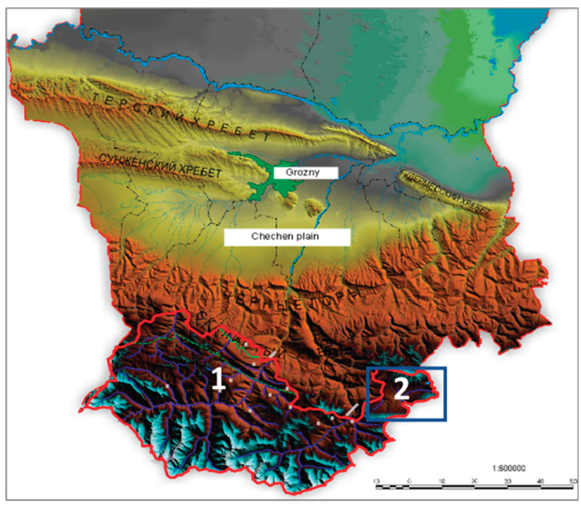
Figure 3.
The territory of the AHAMR on a Sentinel-2 satellite image. Visible range on the left and synthesised colours for vegetation interpretation on the right. Dark green indicates small-leaved and small-leaved coniferous forests, brown indicates mixed and broad-leaved forests.
Figure 3.
The territory of the AHAMR on a Sentinel-2 satellite image. Visible range on the left and synthesised colours for vegetation interpretation on the right. Dark green indicates small-leaved and small-leaved coniferous forests, brown indicates mixed and broad-leaved forests.
Figure 4.
A fragment of a Sentenel-2 series photo (left), its classification (center) and a landscape map (right). The central part of the Argun river valley.
Figure 4.
A fragment of a Sentenel-2 series photo (left), its classification (center) and a landscape map (right). The central part of the Argun river valley.
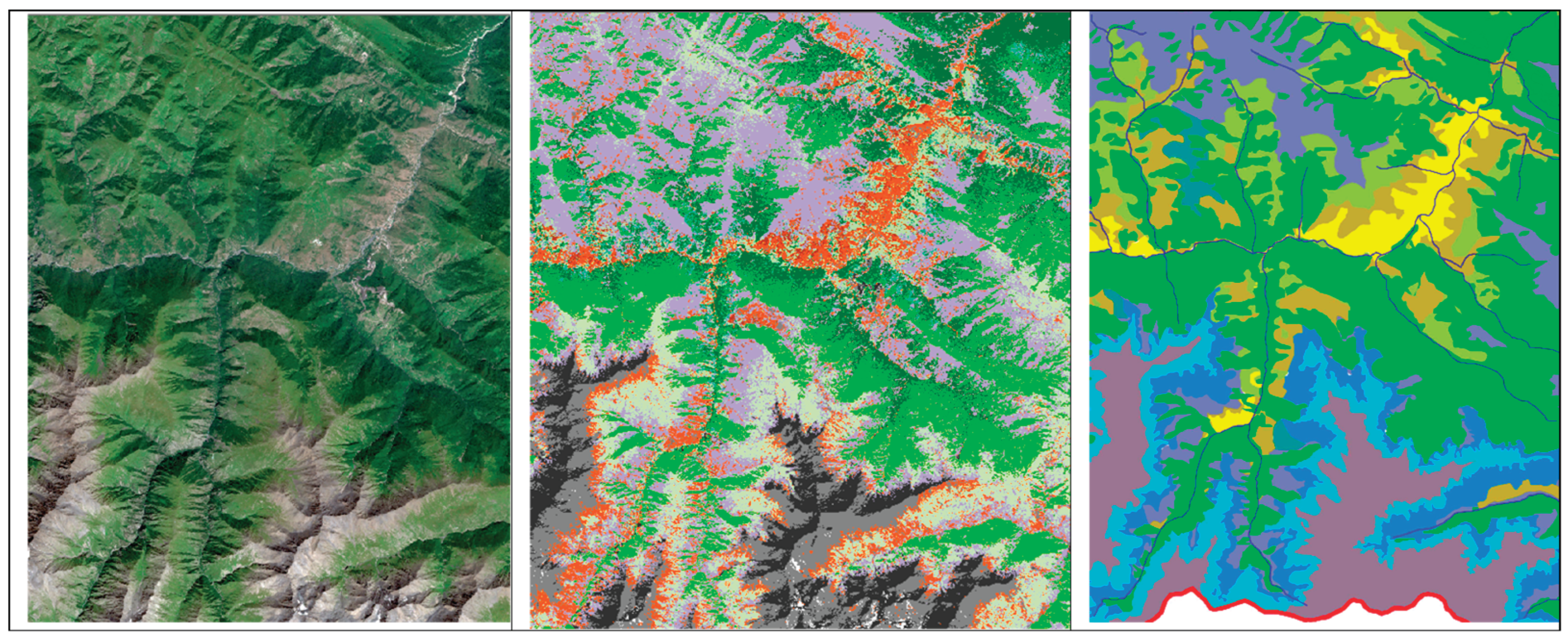
Figure 5.
Forestscapes at the top of a low mountain range, used for performing zikr (circle) in ritual dances of the local population (Sufism).
Figure 5.
Forestscapes at the top of a low mountain range, used for performing zikr (circle) in ritual dances of the local population (Sufism).
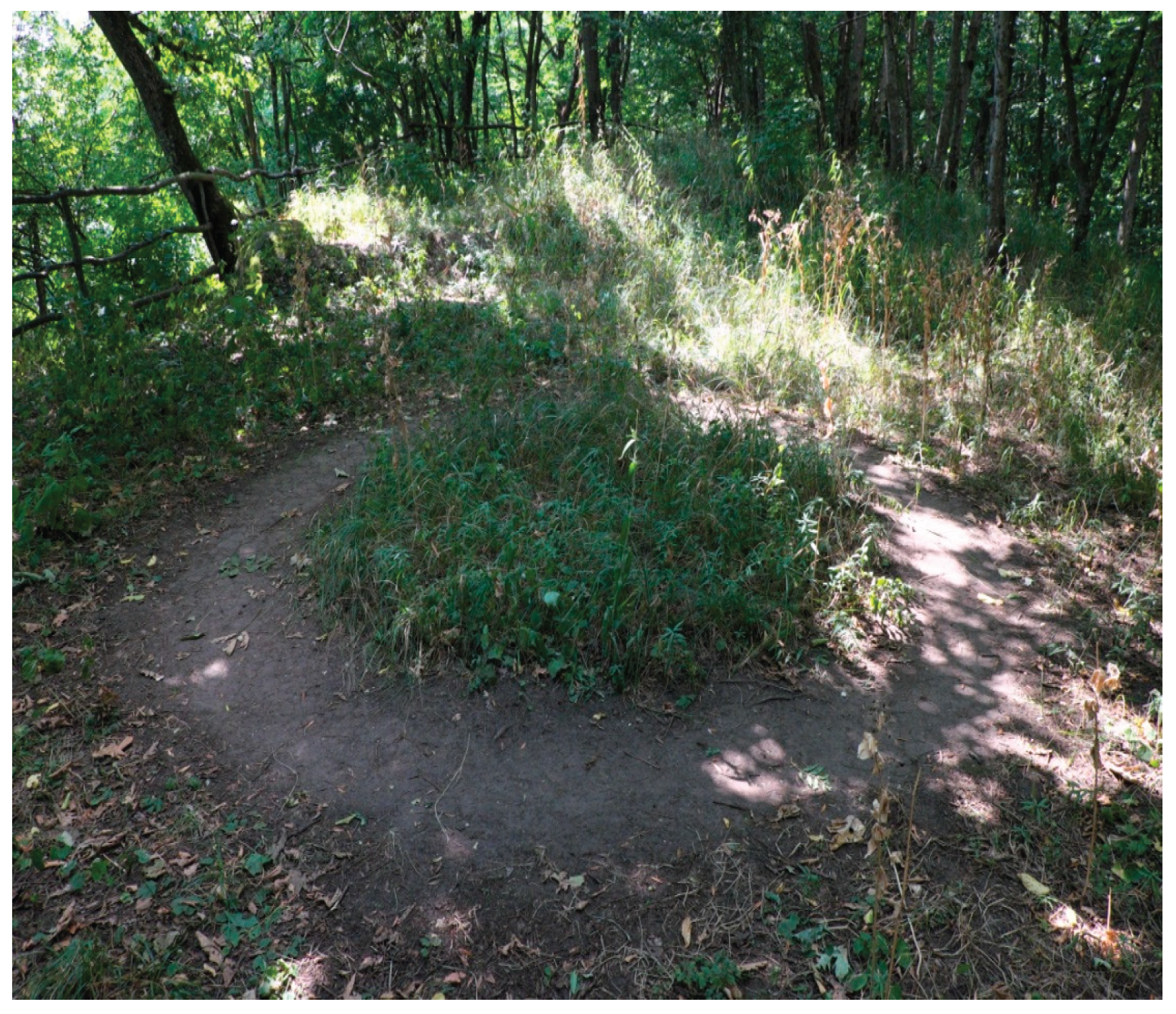
Figure 6.
Forest-steppe forestscapes. In the centre are the ruins of towers, ancient dwellings where mountain dwellers lived 80 years ago.
Figure 6.
Forest-steppe forestscapes. In the centre are the ruins of towers, ancient dwellings where mountain dwellers lived 80 years ago.
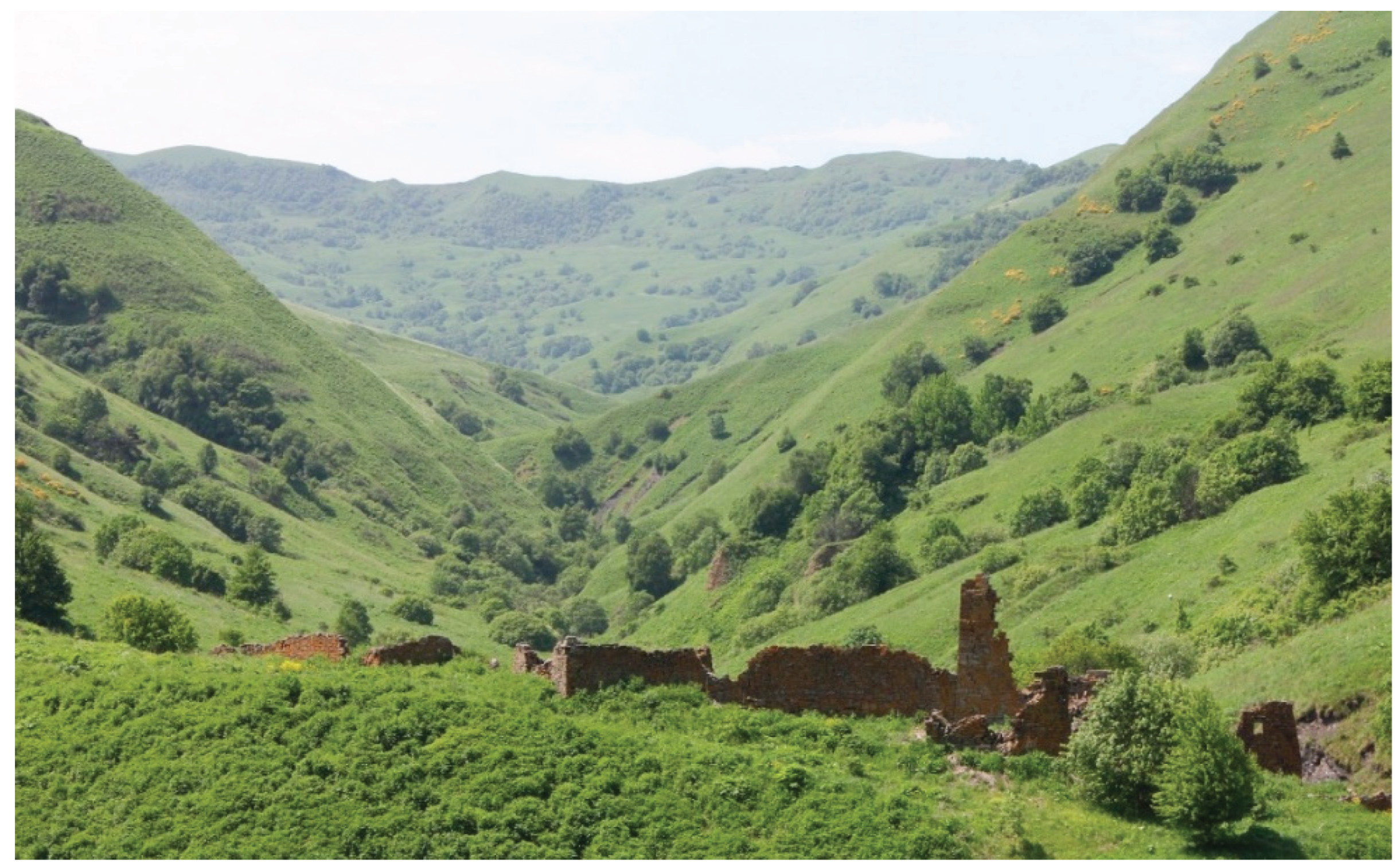
Figure 7.
Forest and forest-steppe landscapes of the Itum-Kalinsky Basin.

Figure 8.
Distribution of settlements (residential and non-residential) by landscapes. 1 – nival and glacial, 2 – alpine and subalpine meadows, 3 – forest-meadow, 4 – forest, 5 – forest-meadow-steppe and forest-steppe.
Figure 8.
Distribution of settlements (residential and non-residential) by landscapes. 1 – nival and glacial, 2 – alpine and subalpine meadows, 3 – forest-meadow, 4 – forest, 5 – forest-meadow-steppe and forest-steppe.
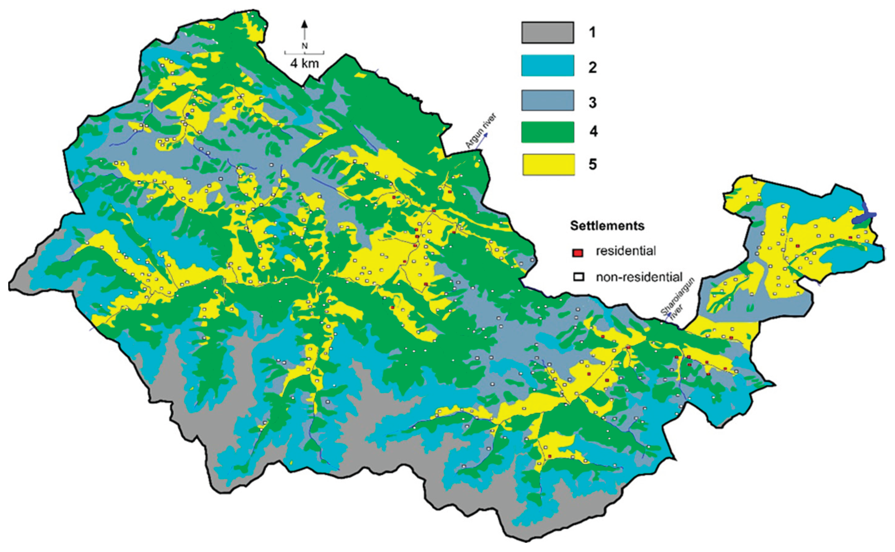
Figure 9.
Number of villages in the study area for three forestscape types: 1 – forest-meadow ecotone, 2 – typical forest, 3 – forest-steppe and forest-meadow-steppe ecotone.
Figure 9.
Number of villages in the study area for three forestscape types: 1 – forest-meadow ecotone, 2 – typical forest, 3 – forest-steppe and forest-meadow-steppe ecotone.
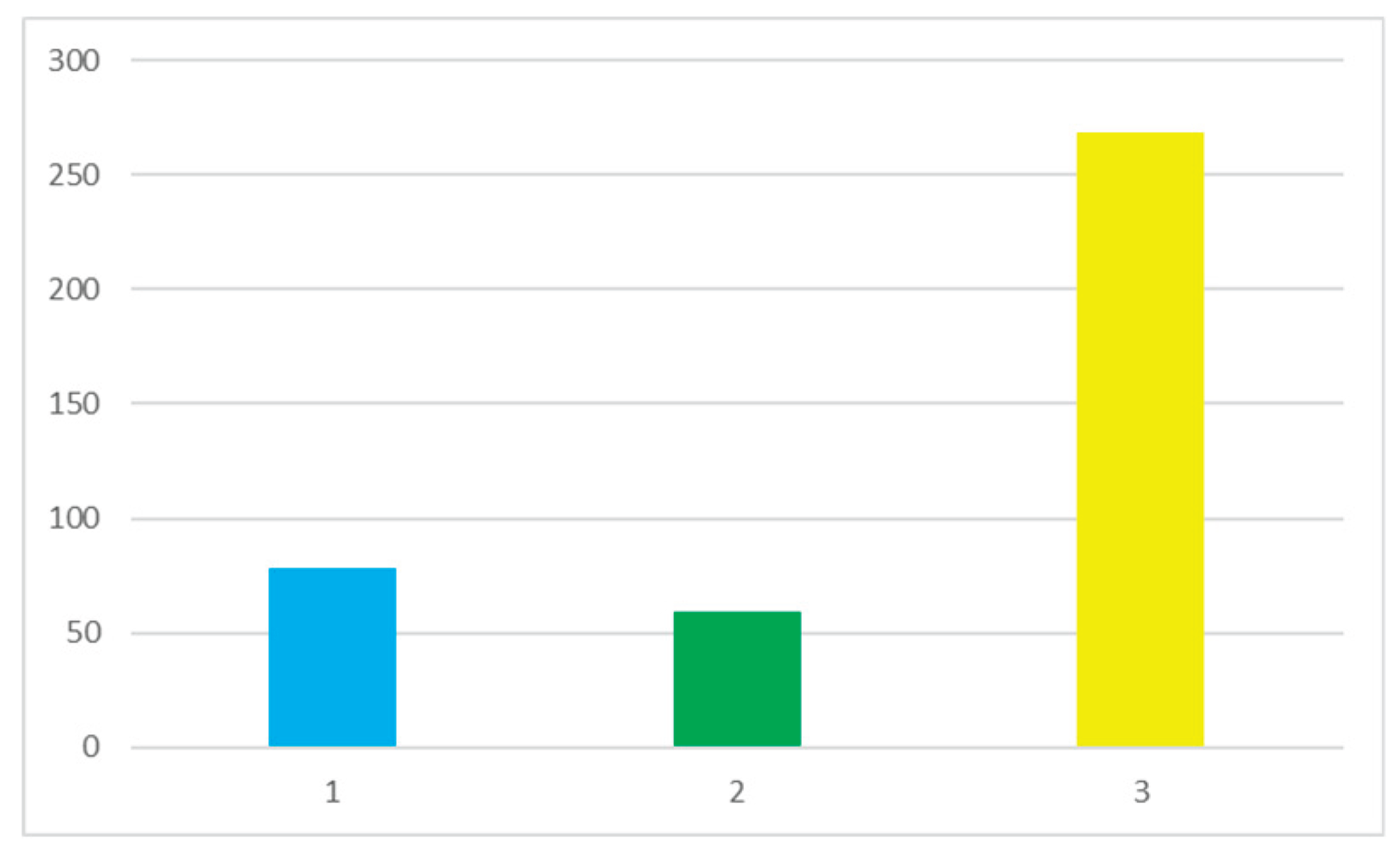
Figure 11.
Dynamics of the upper forest boundary on north-facing slopes adjacent to the high-altitude lake Kazenoy-Am (water level 1,854 m), 2014–2024. The reduction in grazing and climate warming are causing the upper forest boundary to shift upwards and forest stands to become denser. On the other hand, forest stands are being reduced due to the construction of tourist facilities.
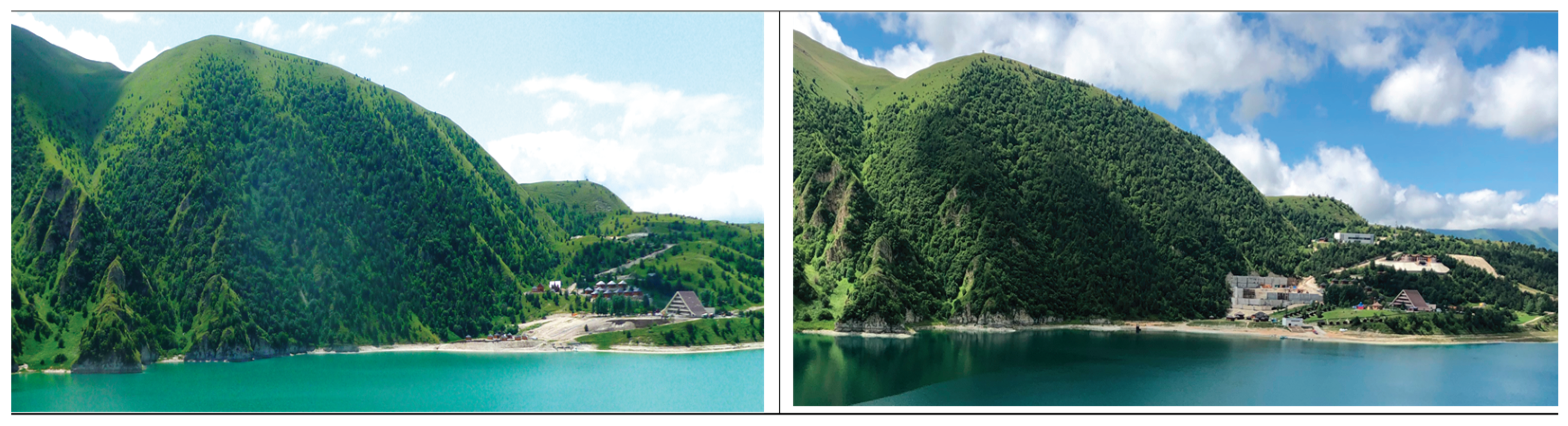
Figure 12.
Ecotones in the Makazhoi Basin: dominant ecosystems and land use institutions (see Table 4). Dominant ecosystems: 1 – dry steppe, 2 – meadow steppe, 3 – forest meadow steppe, 4 – subalpine steppe, 5 – broadleaf forest, 6 – coniferous-small-leaved forest, 7 – forest meadow, 8 – subalpine, 9 – alpine. Institutional combinations: A – state institutions prevail, B – de facto use takes place within the framework of family and clan institutions, C – a combination of state regulation and collective use.
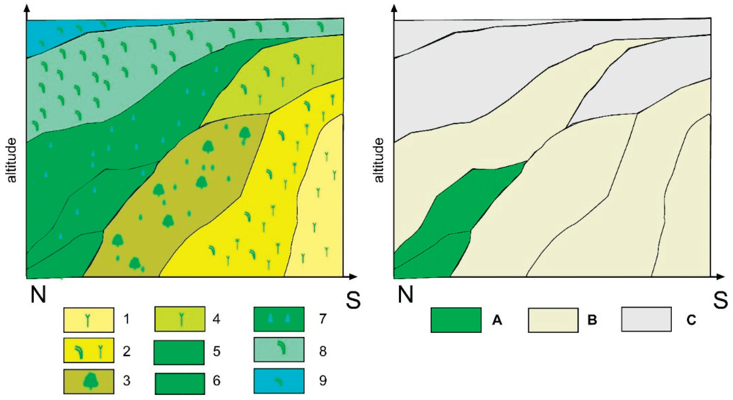
Figure 13.
Makazhoi Basin in the middle part. On the southern slopes there are terraced fields, while on the northern slopes there are forest areas.
Figure 13.
Makazhoi Basin in the middle part. On the southern slopes there are terraced fields, while on the northern slopes there are forest areas.
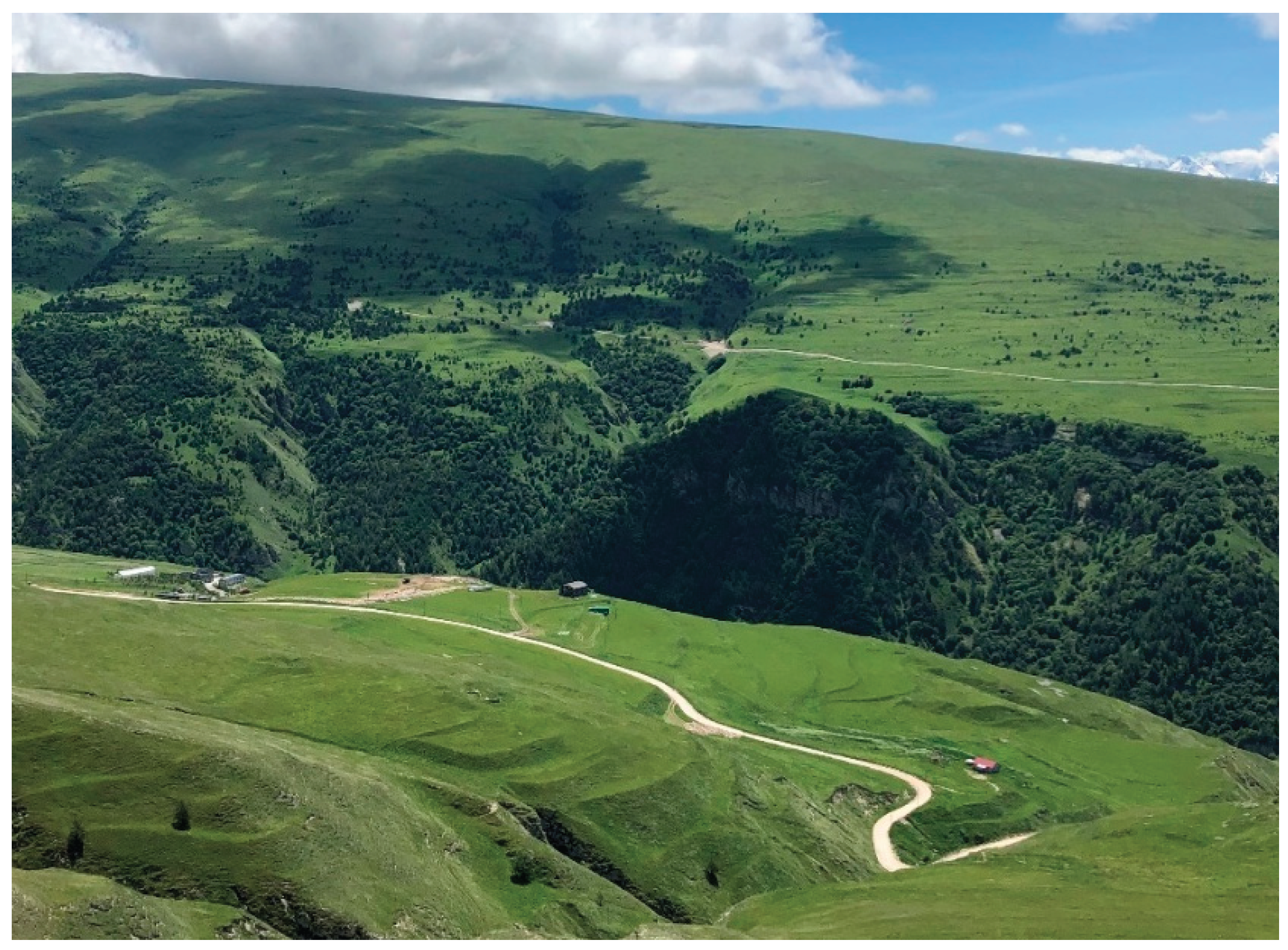
Figure 14.
Expansion of forest areas on the northern slope of the Makazhoi Basin. Green indicates the spread of forests, while blue indicates the appearance of forests over the last 20 years.
Figure 14.
Expansion of forest areas on the northern slope of the Makazhoi Basin. Green indicates the spread of forests, while blue indicates the appearance of forests over the last 20 years.
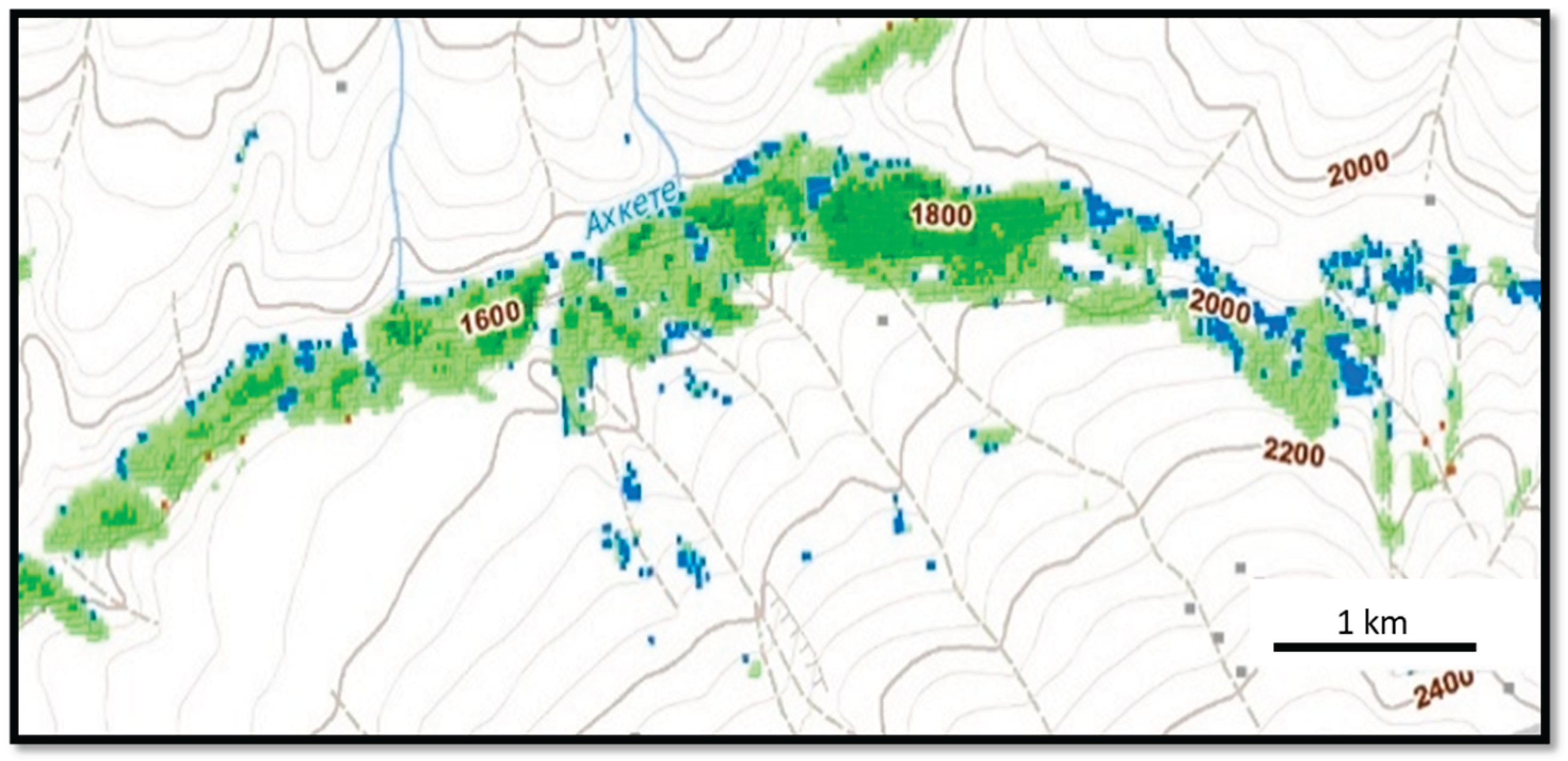
Table 1.
Seasonal maximums of aboveground phytomass in terms of dry weight (t/ha). Based on about 90 measurements.
Table 1.
Seasonal maximums of aboveground phytomass in terms of dry weight (t/ha). Based on about 90 measurements.
| Forest subtypes | Seasonal maximums of above-ground phytomass, dry weight (t/ha) | Average number of tree-shrub/herbaceous species |
|---|---|---|
| Forest-meadow | 20-30 | 2-3/30-40 |
| Small-leaved and coniferous-small-leaved | 50-100 | 3-5/40-50 |
| Broad-leaved | 200-360 | 6-8/10-15 |
| Meadow-steppe shrub | 2-7 | 5-8/40-60 |
| Forest-steppe |
5 (up to 50 in park groves) |
5-7/30-50 |
Table 3.
Changes in the areas of the main types of high-altitude ecosystems in the North Caucasus (above 2000 m) for the period 2000-2020.
Table 3.
Changes in the areas of the main types of high-altitude ecosystems in the North Caucasus (above 2000 m) for the period 2000-2020.
| Nival-glacial | High-altitude meadows | High-altitude forests | ||||
|---|---|---|---|---|---|---|
| Decrease | Growth | Decrease | Growth | Decrease | Growth | |
| Area ha | 6 521,98 | 0 | 39 785,39 | 20 906,25 | 14 384,27 | 39 785,39 |
| % | 100% | 0 | 65,55% | 34,45% | 26,55% | 73,45% |
| Total ha | 6 521,98 | 60 691,64 | 54 169,66 | |||
Disclaimer/Publisher’s Note: The statements, opinions and data contained in all publications are solely those of the individual author(s) and contributor(s) and not of MDPI and/or the editor(s). MDPI and/or the editor(s) disclaim responsibility for any injury to people or property resulting from any ideas, methods, instructions or products referred to in the content. |
© 2025 by the authors. Licensee MDPI, Basel, Switzerland. This article is an open access article distributed under the terms and conditions of the Creative Commons Attribution (CC BY) license (http://creativecommons.org/licenses/by/4.0/).
Copyright: This open access article is published under a Creative Commons CC BY 4.0 license, which permit the free download, distribution, and reuse, provided that the author and preprint are cited in any reuse.


