Submitted:
13 September 2023
Posted:
15 September 2023
You are already at the latest version
Abstract
Anthropogenic disturbances interacting with natural disturbances, ecological and socio-economic factors can provoke forest degradation and modulate ecosystem resilience. In Haiti, protected areas recently created to reduce forest loss, require studies about forest dynamics and land use to assure the development of sustainable management policies. We combine field interview with Landsat satellite images of the Macaya National Park collected between 1985 and 2021 to investigate: 1) how much of the original forest area has been converted into agricultural or logged area since 1985; and 2) how do elevation and slope influence the expansion of human-induced land-use changes. Our results indicate an increase of 11.36% in forest cover and a reduction of 75.34% in agriculture class cover, despite the passage of seven hurricanes in the region. Forest recovery was apparently unrelated to elevation and slope, and likely reflected the implementation of new environmental laws and policies with the creation of the Macaya National Park in 1983. Restoration and protection programs contributed to ensure access to financial resources, technical assistance and new technology, thus promoting a shift into a more resilient forest system. This study brings hope for forest conservation in Haiti by showing that positive results can be achieved through inclusive collaboration.
Keywords:
shifting agriculture
; logging
; remote sensing
; land-use change
; resilience
; social-ecological system
1. Introduction
In the context of growing global population and their needs for natural goods and services, forests ecosystems have been subject to increasing anthropogenic disturbances [1,2]. Logging and shifting agriculture are two widespread and well-known human-induced disturbances in tropical forests [3,4,5,6,7]. These land uses are influenced by a complex interplay between socioeconomic, political, demographic, technological, and biophysical variables and can generate either positive or negative outcomes in the long term [8,9]. In addition, they operate in combination with natural disturbances such as hurricanes, that can exacerbate their impacts [10,11]. Hurricanes are frequent disturbances in Haiti, accompanied by intense wind and heavy rain that can induce massive tree mortality [12,13]. While human population growth or market demand can lead to expansion or intensification of agriculture and logging at the expense of natural forests [14,15,16], hurricanes can reinforce the impacts caused by these human activities as they intensify tree mortality through windthrow, floods and landslides [17,18].
When it comes to land-use change processes, particularly in mountain landscapes, environmental factors such as elevation and slope play an important role as they place physical limits on the types of land-use practices that are feasible in a region [19,20]. Higher terrains with steeper slope are more unlikely to be used for agriculture given that their productivity is frequently lower and greater resources and labor efforts are necessary to produce there, in addition to the fact that these lands are often less accessible [15,21,22,23]. Similarly, logging is also less likely to be practiced in higher and steeper forested areas for the same reasons [22]. Consequently, flatter areas at lower altitude are expected to be impacted first and more intensely during land-use change [15,22]. Local topography is also a complicating factor for hurricane-induced damage. Higher mountain slopes exposed to wind are usually most vulnerable to hurricane damage, whereas lower areas sheltered from the wind are generally least vulnerable [17,24].
Shifting cultivation is a diverse and dynamic land use [14,25]. By using fire, farmers open sites in primary or secondary forests for cropping, and as soon as these sites begin to lose productivity, other sites are opened [26,27,28]. Due to this typical rotation between fallowed and cropped periods, forested land availability is fundamental to the sustainability of shifting agriculture [14]. Selective logging is a more subtle human-induced disturbance than shifting agriculture [29]. Loggers degrade primary forests by harvesting massive trees of commercially valuable species and often damaging others in the process [30,31,32].
When forests are disturbed, changes in ecological and social processes may disrupt interactions and feedbacks that maintained the system resilient, such as the ancient ecological knowledge of local peoples that maintain forests rich in food resources [33]. These changes may trigger other types of positive feedbacks [34], potentially arresting the ecosystem in a degraded state [35]. Positive feedbacks are interactions in which the corresponding outcomes reinforce previous changes [34,36]. For instance, forest cover loss due to hurricane windthrow leaves the ecosystem vulnerable to topsoil erosion which further intensifies forest degradation and reduces forest resilience [37]. Feedbacks play an essential role in ecosystem dynamics as they are able to weaken ecosystem resilience and consequently push them to alternative stable states [8,34,36,38]. Resilience is the capacity of social-ecological system to absorb disturbance and reorganize while undergoing changes so as to still retain essentially similar function, structure and feedbacks, thus assuring the continuous provision of desired sets of ecosystem services to human societies [39,40]. Thereby, a good comprehension of the main drivers of social-ecological change and how they interact with the underlying variables at different levels is crucial for a proper management of forest ecosystems exposed to human and natural disturbances [41].
Shifting agriculture and selective logging are the dominant human activities driving land use changes in Southern Haiti highlands [42,43]. In this region, The Macaya National Park (MNP), created in 1983, protects a substantial part of the last patches of primary mountainous vegetation in the country [44,45]. The MNP is situated in an area which is frequently affected by hurricanes (Table 1) [13,46,47] that can induce large-scale sudden tree mortality and changes in forest composition [12,48]. The combination of human disturbances such as shifting agriculture and logging, natural disturbances such as hurricanes and the topographic complexity of the MNP that affects hurricane exposure, makes this site a special opportunity to study the combined effects of such factors in the tropical belt of the Americas. The mixed effects of land use changes and natural disasters can lead to biodiversity loss [29,49], reducing ecosystem resilience [36] and consequently, threatening the provision of essential ecosystem services to Haitian peoples. Forests in the Macaya National Park provide substantially timber for construction and furniture making, firewood for cooking and heating, foods, medicinal plants and water for domestic uses, livestock watering and crop irrigation [42]. Due to its ecological importance and the pressures that threaten its existence, the MNP has attracted the attention of several public institutions, non-governmental organizations (NGOs) and other research institutions which began to participate at different levels in the governance of the park [42].
In this study, we combine satellite and field data to assess how the forest landscape of the Macaya National Park in Southern Haiti has been changing under the combined effects of shifting cultivation, selective logging and hurricanes from 1985 through 2021. To achieve this goal, we seek to answer the following questions: (1) how much of the original forest area has been converted into cultivated or logged area since 1985; and (2) how do elevation and slope – which affect accessibility, hurricane and land-use exposure – influence the expansion of human-induced land cover changes.
2. Materials and Methods
2.1. Study area
The present study was conducted in the Macaya National Park (MNP) located in Southern Haiti (Figure 1). The park was created in 1983 and presently compounds the central zone of “La Hotte” Biosphere Reserve admitted by the United Nations Educational, Scientific and Cultural Organization (UNESCO) in 2016 [44,50]. The area of the MNP was 8,166.34 hectares until 2013 when it was extended to more than 13,000 hectares that protects the last fragments of original Southern Haiti vegetation and its fauna [42]. For this study, we will consider only the older limits of the MNP as the other part were under a different protection regime until 2013.
The topography of the MNP is quite hilly, with various steep slopes and ravines [52]. The MNP climate has moderate temperatures ranging from 5 to 20º C and two rainy periods – one from April to June, other from August to November – with an average of 2,500-3,000 mm of mean annual rainfall [53]. The predominant soil types are dark red oxisols (with nearly neutral pH and moderate fertility levels) that occupy mostly flat plains and lowest slopes, and brown ultisols (with slightly acid pH and commonly deficient in nitrogen and phosphorus) present in many intermediate and upper slopes [43]. Between 800 and 2000 meters of altitude, broadleaf forests predominate, whereas above 2000 meters, pine forests predominate in the landscape [42].
We selected six of the most populated local villages inside or near the borders of the park: Kay Michel, Kadose, Mahodème, Denord, Deglacis and Plymouth to assess land-use impacts with interviews (Figure 1). We also selected two other locations inside the park: Pic Macaya and Pic Formond which are uninhabited as control areas (Figure 1). The village Kay Michel is in the southern part of the MNP at the end of one of the principal roads giving access to the park and has important administrative infrastructures used by researchers and state agents. It belongs to the rural district of Carrefour Canon which has a population of 10,433 inhabitants. The village Deglacis in the East of the MNP has more than 2,000 inhabitants. It is a remote village accessed only by heavy trails starting from the southern villages. Kadose in the northwest of the park belongs to the rural district of Randel which has 6,550 inhabitants. Mahodème in the western zone of the MNP belongs to the rural district of Dejoie which has approximately 6,000 inhabitants. Denord is part of the rural district of Beaumont which has a population of more than 12,000 inhabitants [42]. Pic Macaya (2,347 m) and Pic Formond (2,219 m) are both uninhabited places located in the central part of the MNP and represent the highest peaks in the region.
Although the Macaya region has been occupied since the colonial period in the 18th century, local human population has increased mostly through in-migration in the 1960s [42,43]. Historically, traditional shifting agriculture has been the most important economic activity for these communities [42,43]. Farmers alternate cropped and fallowed periods in plots initially open in areas of primary or secondary vegetation managing fire. They mostly grow annual crop species like Manihot esculenta (cassava), Dioscorea sp.(yams), Xanthosoma sp. (malanga), Colocasia esculenta (taro), Ipomea batata (sweet potatoe), Zea mays (corn) and a wide variety of beans [42,54]. They also grow perennial crop species like Coffea arabica (coffee), Musa sp. (bananas) and some other fruits [54]. In addition, local people practice livestock raising and logging to complement household income [55]. During the fallow period, plots are used as pastures for livestock which is compound mostly by oxen and goats [54]. Fallows are often characterized by a naturally grown herbaceous vegetation [43].
2.2. Data acquisition and pre-processing
To assess land-use change in the MNP, we selected Landsat images with low or without cloud cover from 1985 through 2021 applying a cloud cover filter (below 10% cover) to all the available Landsat images for this period [56]. The image selection process resulted in 136 suitable images that were organized into four time periods of approximately 10 years: the first from 1985 through 1995 with 16 images; the second from 1995 through 2005 with 25 images; the third from 2000 through 2012 with 14 images and the fourth from 2013 through 2021 with 81 images. We computed the Normalized Difference Vegetation Index (NDVI) [57] and Normalized Difference Water Index (NDWI) [58] for all non-masked pixels for these images. These two indices are useful to define land cover classes and have been previously used to assess land-cover changes in tropical forests [59,60]. Then, we performed image collection reductions taking the median of the spectral indices values per pixel over each time period, which resulted in four images representing the four time periods. This pre-processing step was performed to reduce the influence of single outliers and to take the best pixels available for each time-period [61]. All the images were cropped to the MNP area polygon to reduce processing time.
2.3. Data analysis
After the pre-processing step, we applied a supervised classification on the four images resulting from the image collection reduction process and representing each time period from 1985 through 2021. First, we collected polygon samples by on-screen digitizing in Google Earth Engine [61] for four land-use classes: agricultural land, forest, bare soil and water. Second, the polygon samples were divided in two data sets: one with 70% of the samples as training data and another one with the 30% remaining, to be used as validation data. We trained the RandomForest classifier using the training data set and performed a supervised classification of the four images. We estimated classification error with the independent validation data set [62]. We calculated the corresponding area of each land-use class for each of the four time periods and compared the results to identify land use changes across the MNP.
We delineated a 1,500 m buffer around the center of each selected local village (Figure 2) and calculated the proportional area covered by the different land-cover/land-use classes for each period.
3. Results
During the time span of this study (1985 - 2021), forest and agriculture land-use classes were highly more representative than water and bare soil classes (Figure 2). We detected an increase in 11.36% of the area covered by forest while agriculture area decreased 75.34% between 1985 and 2021 (Figure 2, Figure A1). For the whole MNP, forest expanded from 84.35 km2 in the first time-period (1985-1995) to 93.94 km2 in the last one (2013-2021). At the same time, agriculture declined from 12.33 km2 to 3.04 km2. For the two remaining land use classes bare soil and water, we observed that bare soil increased from 0 to 1.76 km2, while water reduced from 2.35 to 0.29 km2 (Figure 2, Figure A1).
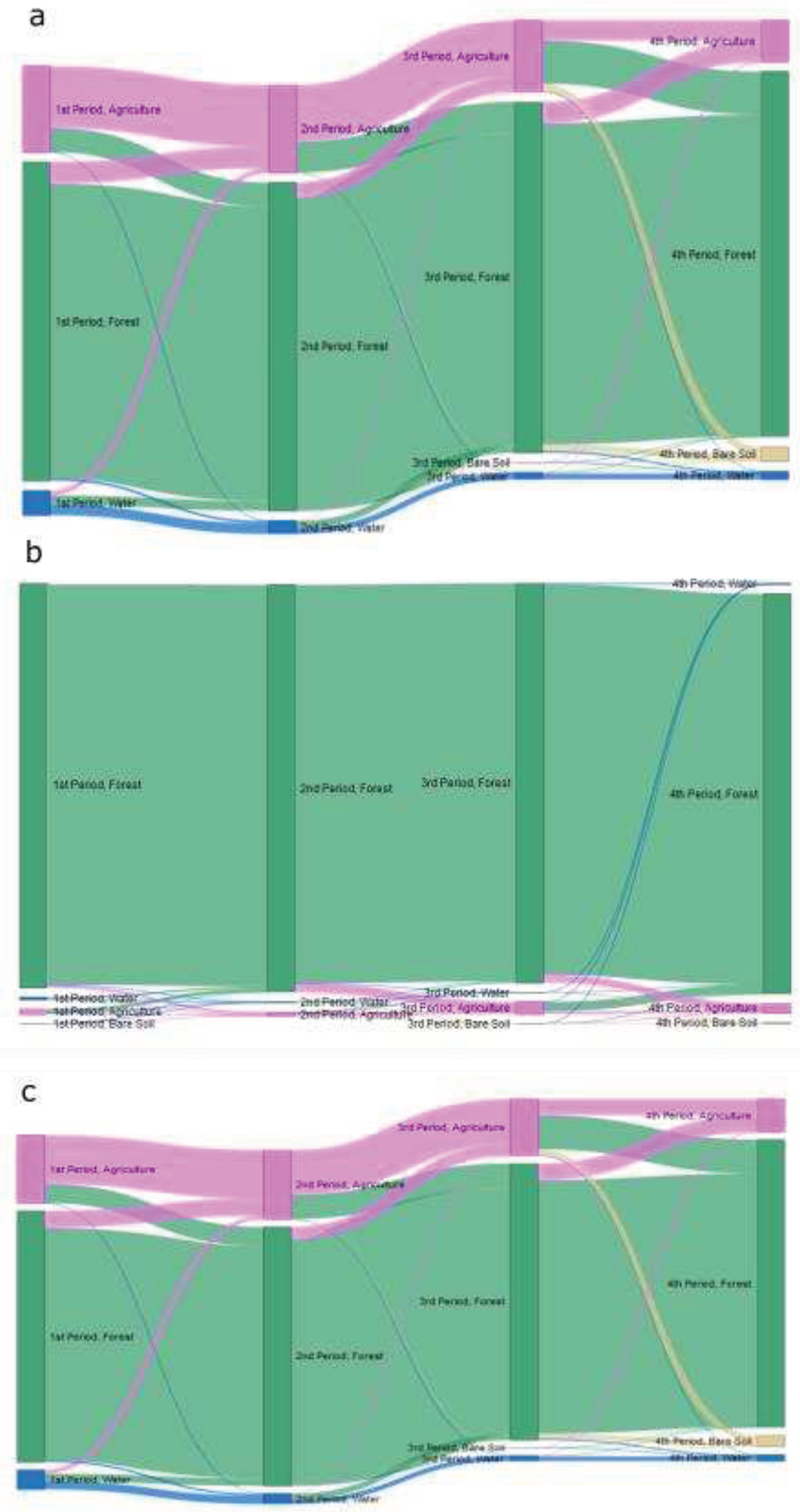
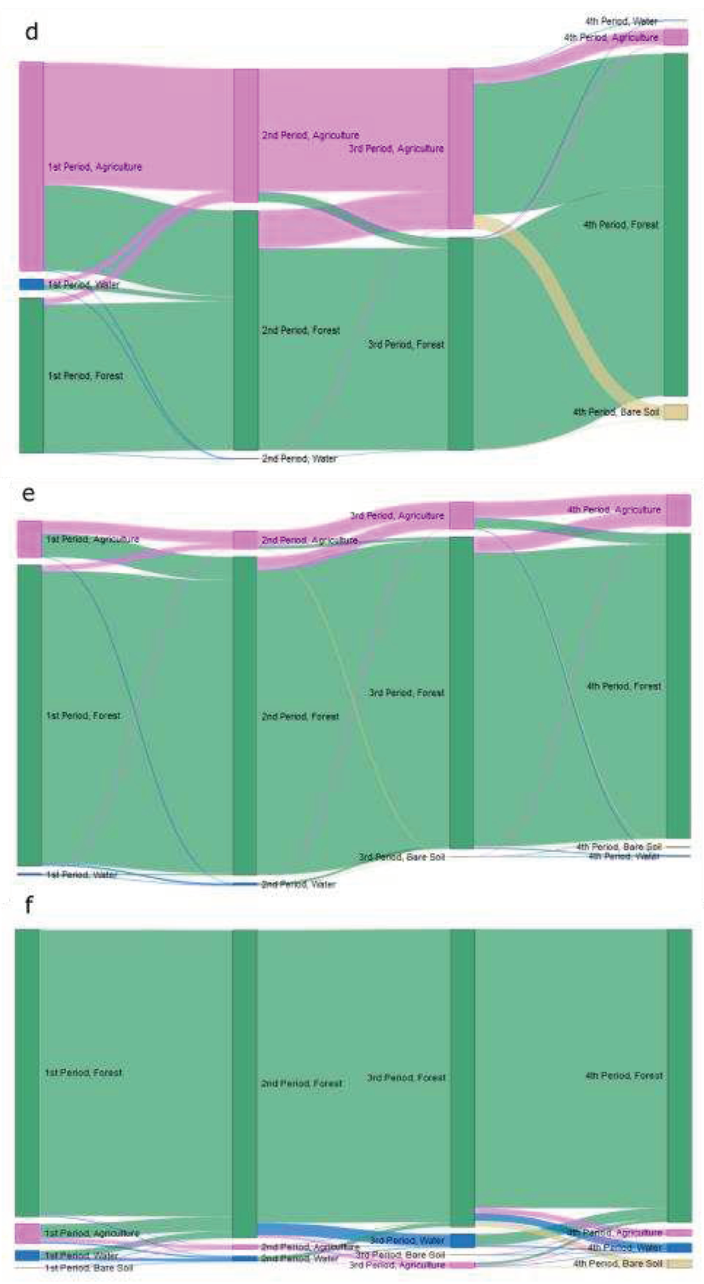
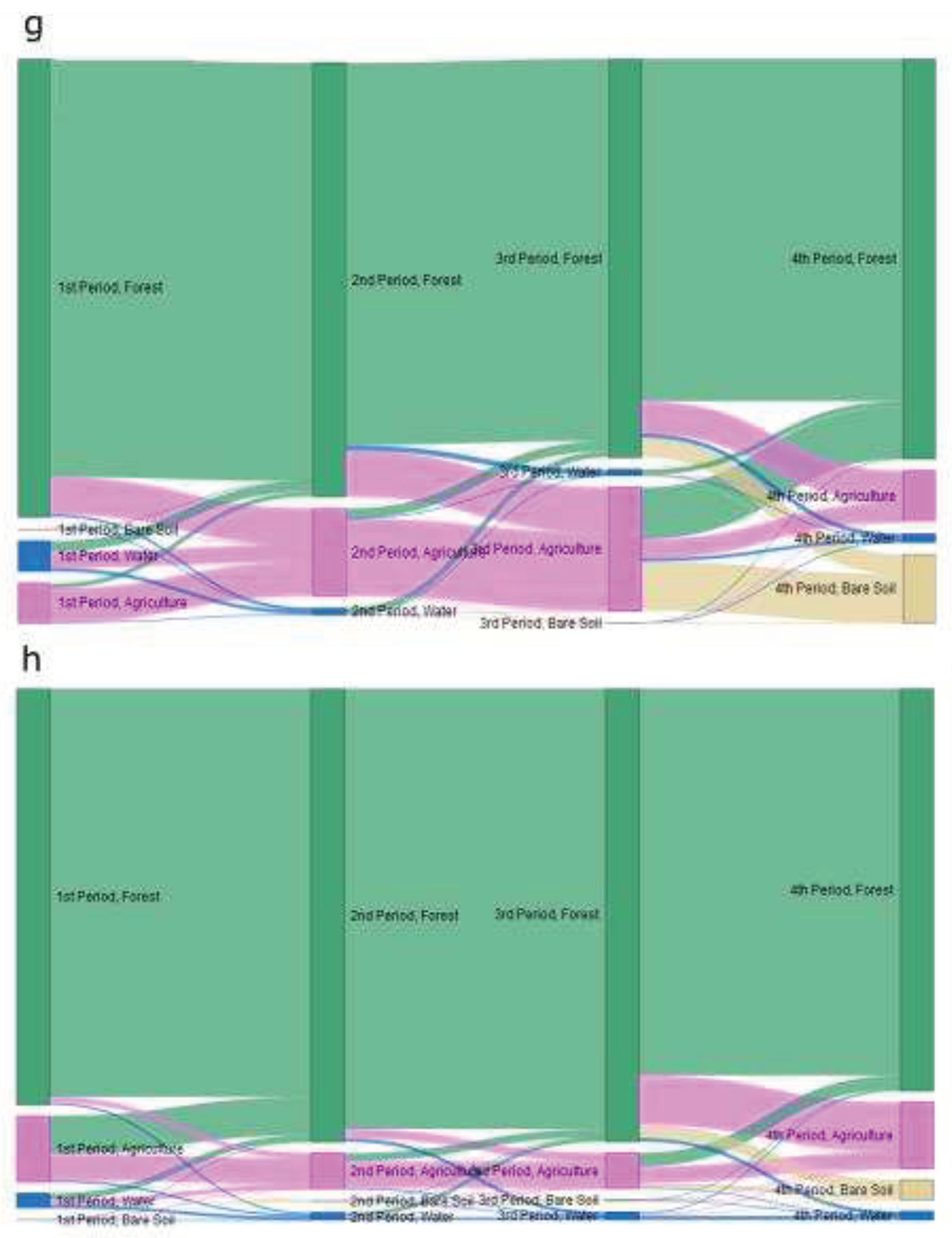
Analysis of the village surroundings revealed that forest and agriculture areas remained relatively stable over time in Denord (Figure A2, b), Pic Formond (Figure A2, f), Pic Macaya (Figure A2, h), Mahodeme (Figure A2, e) and Deglacis (Figure A2, a), whereas major land-use changes took place in Kadose, Kay Michel and Plymouth (Figure A1; Figure A2, c, d and g). In Kay Michel, agricultural use that initially occupied 53% of the sampled area, dropped drastically to 3% in the last time-period (2013-2021). At the same time, forest area expanded from 47 to 95% from the first (1985-1995) to the last time-period (2013-2021) (Figure A1; Figure A2, d). In Kadose, forest area increased from 66 to 86 % while agricultural area decreased from 17 to 2% (Figure A1; Figure A2, c). In Plymouth village, agricultural land cover increased from 3 to 17% in the first decade of the 2000’s and then decreased to 7% in the period of 2013-2021, whereas total forest cover decreased from 96 to 81% and then increased again to 87% (Figure A1; Figure A2, g).
4. Discussion
4.1. Socio-economic factors affecting land-use/land-cover changes
Our results revealed an increase of forest area within the MNP since 1985. This finding is congruent to changes occurring in many tropical landscapes under forest transition, i.e., a shift from forest loss to forest gain [70,71,72]. Forest transition has contributed to reduce tropical deforestation although the rates at global scale remain alarmingly increasing [70,73]. A detailed analysis demonstrated that major land-use changes occurred in Kay Michel, Kadose and Plymouth villages situated respectively in Southern and Southeastern zones of the MNP, where important gain in forest area occurred at the expense of agricultural land-use. To understand these changes, we examine a set of social-ecological factors that might be influencing land-use dynamics in the MNP region.
The village of Kay Michel hosted the Macaya Biosphere Reserve Project (MBRP) headquarters which had a crucial role for the conservation efforts in the MNP region. The MBRP got together a diversified group of researchers, technicians and volunteers from the University of Florida (UF), the Ministry of Agriculture and Natural Resources of Haiti (MARNDR) and local people in order to preserve and rehabilitate the unique relictual montane ecosystems in the Macaya region, thus assuring its sustainable economic development [43]. The MBRP lasted four years – from October 1988 to May 1992 – and was financed by the United States Agency for International Development (USAID) to an amount greater than US$ 1,5 million. With the MBRP progress, important restoration activities in critical zones like steep slopes, springs and endangered habitats – that have been environmentally degraded – were implemented. Such degraded areas in Kay Michel received direct seedlings of native useful species such as Pinus occidentalis, Didymopanax tremulus, Micropholis polita ssp. hotteana and Tabebuia conferta. Similar activities were also conducted in different villages dispersed across the MNP [43].
Simultaneously to the restoration of degraded critical areas in the landscape, the MBRP carried out policies aiming to reduce the impacts of human exploration on the natural vegetation without forgetting to provide reasonable economic alternatives. For example, a new zoning of the MNP established at the beginning of the MBRP strictly prohibited agriculture, grazing and logging in some areas that were once used for such purposes. At the same time, local people were hired to maintain and supervise seedling nurseries, to transplant seedlings and work as local guides for tourists and researchers. Farmers also received financial and technical assistance to improve agricultural productivity in areas where it was still allowed [43].
In addition to the MBRP, other projects have been executed in the MNP region, such as the Environmental Education for Community Participation in Conservation of Macaya [74], and the Ecosystem Threat Assessment and Protected Area Strategy for the Massif de la Hotte Key Biodiversity Area [75] which addressed respectively the creation of local environmental committees that advocate for a stronger participation of local communities in the management of natural resources in the MNP area, and for developing self-sustaining education and public outreach activities. These actors all actively contributed to improve forest conservation and sustainable development as they brought financial resources, technical assistance, new sources of technology and new ideas and networks of contacts to local communities [76,77]. Major challenges such as insufficient funding, lack of continuity, political instability and the terrible quality of roads which hinder the access to some targeted areas may have contributed to lessen the expected positive outcomes [76,78]. However, as our results show (Figure 2; Figure 3), these initiatives clearly had major positive impacts, allowing tropical forests in that region to recover.
4.2. Ecological factors affecting land-use/land-cover changes
Elevation and slope have been identified as constraints to the expansion of human activities over natural forests [15,19,20]. During degradation process, lowland forests on flatter terrains are more likely to be impacted first and more intensely, particularly when near human settlements [15,21,22,79]. Our results showed a similar pattern. The highest elevations (Figure 3A) and areas with steepest slopes (Figure 3B) in our study area, for instance Pic Macaya and Pic Formond, remained relatively stable, with forest land cover dominance. This observation can be explained by low accessibility due to the inexistence of roads, but only narrow trails to reach such places, and also difficulties created by steepness making logging and agriculture unprofitable there.
Local topography has also an important influence on damage pattern induced by hurricanes in tropical forests [17,80]. The wind and rain that accompany hurricanes can cause massive tree mortality, due to windthrow, floods and landslides [12]. Tree mortality is expected to be greater on upper windward slopes than on leeward lower terrains as upper slopes are most vulnerable to hurricane damage [24,80]. Given that part of elevated steep terrains in the MNP is also exposed to logging and shifting agriculture, even to a lower level, combined impacts of hurricanes and land uses can eventually induce unexpected changes that undermine the MNP resilience.
Nonetheless, the forest transition we observed in the region may have contributed to increasing forests resilience to hurricanes. Well conserved forests are likely more capable of overcoming disturbances by hurricanes because they often have higher biodiversity than degraded forests [29,81,82]. Biodiversity allows ecosystems to maintain various species, with complementary and redundant functions, which in the face of disturbances increase their response diversity; while some species die during hurricane event, others persist, keeping the ecosystem functioning [81,83]. Response diversity is therefore an important aspect of ecosystem resilience and by reducing biodiversity, agriculture and logging undermine ecosystem resilience. These mechanisms may have helped forests on higher elevations and steeper slopes, as well as restored forests to remain stable in the face of several hurricane events (see Table 1). However, other forests in the MNP persisted degraded and relatively more exposed to these disturbances.
When hurricanes, such as the powerful hurricane Matthew in 2016, hit degraded forests areas in the MNP landscape, their impacts can be exacerbated as degraded forests are exposed to increasing wind speed, turbulence and vorticity [17,84]. These factors intensify tree mortality and reduce forest cover [84], which further increases ecosystem exposure to other disturbances, such as fire [85], and to other degrading mechanisms, such as topsoil erosion [37]. As a result, forests may persist in a degraded state [35,84], which may not provide the desired set of ecosystem services necessary to ensure local people well-being. Although we observed an expansion of forests over agricultural land cover in the MNP, since forest land cover was a broad category including agroforests and multi-aged secondary forests, our study may have not detected ongoing homogenization and simplification processes. Therefore, future studies using images with finer resolution, greater number of land use classes, as well as accurate field information on species composition and diversity will help to elucidate more detailed aspects of forest dynamics in the MNP region.
5. Conclusions
Tropical montane forests in southern Haiti have been exposed to increasing need for food, timber and firewood in recent decades but this did not reflect on deforestation. The present research revealed that forest area has expanded at the expense of agricultural area from 1985 to 2021 in the MNP region. Such land-use changes in which forests expand are similar to the pattern observed in many tropical landscapes under forest transition [70,71] and are mostly related to changes in environmental laws and policies that provide access to financial and technical assistance and new sources of technology. These positive changes were probably influenced by external intervention from international institutions that increased local communities’ adaptive capacity, allowing them to reorganize their activities and initiate new forms of development, based on sustainable forest management. However, because of the inherent complexity of social-ecological systems [39,77], such as the tropical forests of Southern Haiti, more exhaustive studies assessing the feedbacks at play and the changing drivers are crucial to reveal potential future scenarios that may guide proper management in the MNP region under global change. Finally, this study brings hope for forest conservation in Haiti by showing that, despite the numerous challenges that the country faces, combined efforts of central government, local and international institutions have achieved promising positive results.
Author Contributions
A.S. conceived the initial idea and structure, drafted the manuscript, collected and analyzed field and satellite data. C.S.C. collected and analyzed satellite data and made contributions to their interpretation. B.M.F. and C.C.J. contributed to draft development and brought valuable ideas that improved the structure of the article. N.P. contributed to improve the initial idea and structure, draft development and reviewed early versions. All authors have read the manuscript and agreed to the final version for publication.
Funding
This study was financed in part by the Coordenação de Aperfeiçoamento de Pessoal de Nível Superior – Brasil (CAPES) – Finance Code 001, for Angelet Sylvéus, Nivaldo Peroni (Process 88887.828528/2023-00), and Christhian Cunha (Process 88887.801261/2023-00), and CNPq (Process 307529/2022-3) for Nivaldo Peroni. This work was also supported by the Instituto Serrapilheira – Brasil (Project R-2111-40341, Chamada #5), for Catarina Jakovac.
Data Availability Statement
The present manuscript is part of an ongoing Ph.D. thesis in which were used satellite data provided by the United State Geological Survey (USGS) and the National Aeronautics and Space Administration (NASA) that can be found online at https://developers.google.com/earth-engine/datasets/catalog/LANDSAT_LT05_C02_T1_L2, https://developers.google.com/earth-engine/datasets/catalog/LANDSAT_LC08_C02_T1_L2 and https://developers.google.com/earth-engine/datasets/catalog/NASA_NASADEM_HGT_001.
Acknowledgments
We thank the local dwellers who contributed with their knowledge about shifting cultivation, logging and hurricane impacts in Southern Haiti; the Agence Nationale des Aires Protégées – Haiti (ANAP) and the Parc National Naturel Macaya - Haiti (PNNM) for providing local guides, transport and accommodation facilities during field activities. We also thank the Programa de Pós-Graduação em Ecologia – Brasil (PPGECO-UFSC) for financing travel costs to Haiti.
Conflicts of Interest
The authors declare no conflict of interest.
Appendix
Figure A1.
Land use change in Macaya National Park in four time-periods from 1985 to 2021.
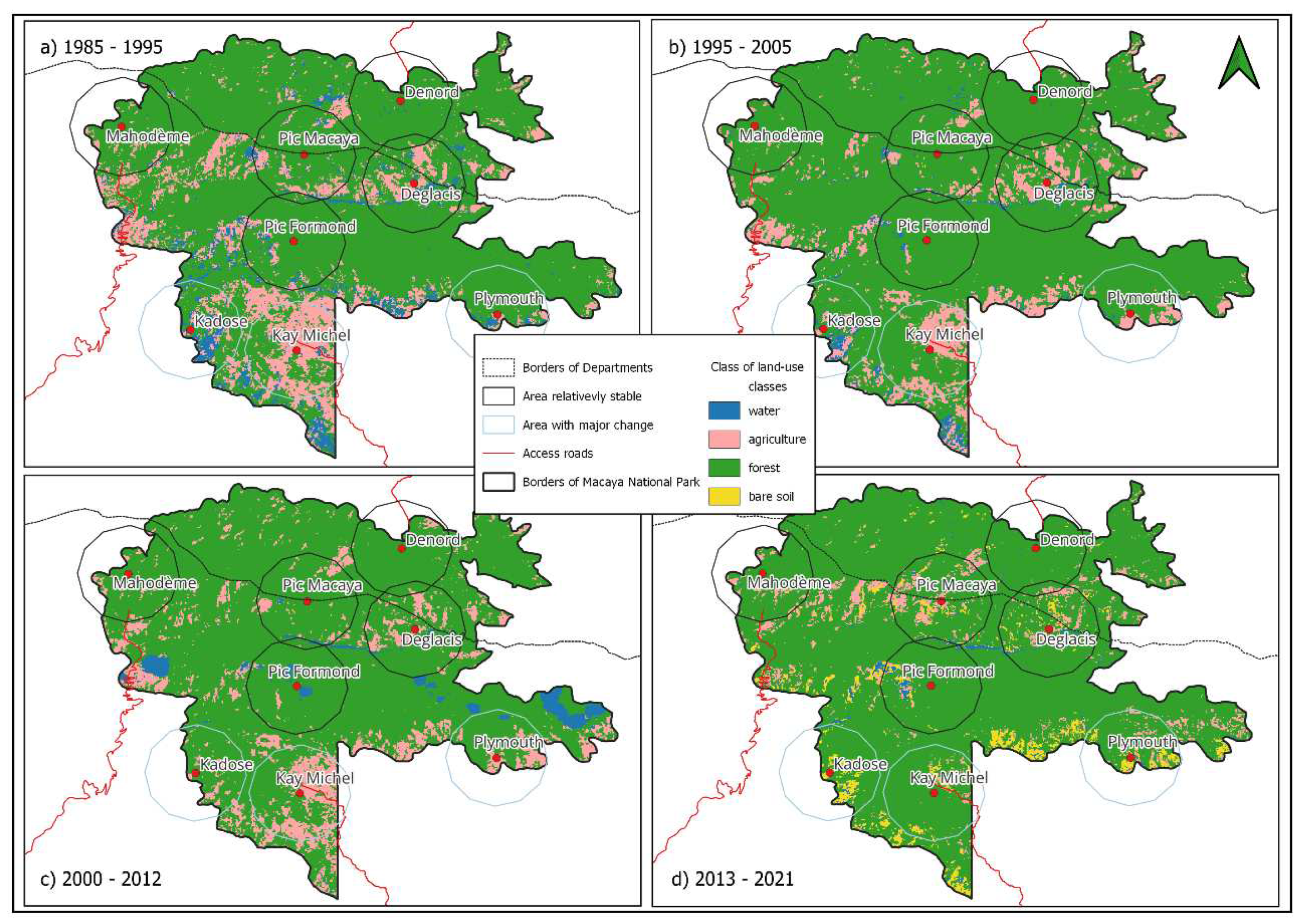
Figure A2.
Area covered by four land-use/land-cover classes in four time-periods, for the selected villages from 1985 to 2021 in Macaya National Park. a) village of Deglacis; b) village of Denord; c) village of Kadose; d) village of Kay Michel; e) village of Mahodeme; f) Pic Formond; g) village of Plymouth; and h) Pic Macaya.
References
- Malhi, Y.; Gardner, T. A.; Goldsmith, G. R.; Silman, M. R.; Zelazowski, P. Tropical forests in the anthropocene. Annual Review of Environment and Resources 2014, 39, 125–159. [Google Scholar] [CrossRef]
- Barlow, J.; França, F.; Gardner, T. A.; Hicks, C. C.; Lennox, G. D.; Berenguer, E.; et al. The future of hyperdiverse tropical ecosystems. Nature 2018, 559, 517–526. [Google Scholar] [CrossRef] [PubMed]
- Mertz, O.; Padoch, C.; Fox, J.; Cramb, R. A.; Leisz, S. J.; Lam, N. T.; et al. Swidden change in southeast Asia: Understanding causes and consequences. Human Ecology 2009, 37, 259–264. [Google Scholar] [CrossRef]
- Asner, G. P.; Rudel, T. K.; Aide, T. M.; Defries, R.; Emerson, R. A contemporary assessment of change in humid tropical forests. Conservation Biology 2009, 23, 1386–1395. [Google Scholar] [CrossRef] [PubMed]
- Kleinman, P. J. A.; Pimentel, D.; Bryant, R. B. The ecological sustainability of slash-and-burn agriculture. Agriculture, Ecosystems and Environment 1995, 52, 235–249. [Google Scholar] [CrossRef]
- Fox, J.; Truong, D. M.; Rambo, A. T.; Tuyen, N. P.; Cuc, L. T.; Leisz, S. Shifting cultivation: A new old paradigm for managing tropical forests. BioScience 2000, 50, 521–528. [Google Scholar] [CrossRef]
- Kadoya, T.; Takeuchi, Y.; Shinoda, Y.; Nansai, K. Shifting agriculture is the dominant driver of forest disturbance in threatened forest species’ ranges. Communications Earth and Environment 2022, 3, 1–8. [Google Scholar] [CrossRef]
- Lambin, E. F.; Meyfroidt, P. Land use transitions: Socio-ecological feedback versus socio-economic change. Land Use Policy 2010, 27, 108–118. [Google Scholar] [CrossRef]
- Lambin, E. F.; Geist, H. J.; Lepers, E. DYNAMICS OF LAND-USE AND LAND-COVER CHANGE IN TROPICAL REGIONS. Annual Review of Environment and Resources 2003, 28, 205–241. [Google Scholar] [CrossRef]
- Gay-des-Combes, J. M.; Robroek, B. J. M.; Hervé, D.; Guillaume, T.; Pistocchi, C.; Mills, R. T. E.; et al. Slash-and-burn agriculture and tropical cyclone activity in Madagascar: Implication for soil fertility dynamics and corn performance. Agriculture, Ecosystems and Environment 2017, 239, 207–218. [Google Scholar] [CrossRef]
- Chazdon, R. L. Second Growth: The Promise of Tropical Forest Regeneration in an Age of Deforestation; 2014; Vol. 134.
- Lugo, A. E. Effects and outcomes of Caribbean hurricanes in a climate change scenario. The Science of the Total Environment 2000, 262, 243–251. [Google Scholar] [CrossRef]
- Pielke, R. A.; Rubiera, J.; Landsea, C.; Fernández, M. L.; Klein, R. Hurricane Vulnerability in Latin America and The Caribbean: Normalized Damage and Loss Potentials. Natural Hazards Review 2003, 4, 101–114. [Google Scholar] [CrossRef]
- Jakovac, C. C.; Dutrieux, L. P.; Siti, L.; Peña-Claros, M.; Bongers, F. Spatial and temporal dynamics of shifting cultivation in the middle-Amazonas river: Expansion and intensification. PLoS ONE 2017, 12, 1–15. [Google Scholar] [CrossRef]
- Schmitt-Harsh, M. Landscape change in Guatemala: Driving forces of forest and coffee agroforest expansion and contraction from 1990 to 2010. Applied Geography 2013, 40, 40–50. [Google Scholar] [CrossRef]
- Pinheiro, T. F.; Escada, M. I. S.; Valeriano, D. M.; Hostert, P.; Gollnow, F.; Müller, H. Forest degradation associated with logging frontier expansion in the Amazon: The BR-163 region in southwestern pará, Brazil. Earth Interactions 2016, 20. [Google Scholar] [CrossRef]
- Laurance, W. F.; Curran, T. J. Impacts of wind disturbance on fragmented tropical forests: A review and synthesis. Austral Ecology 2008, 33, 399–408. [Google Scholar] [CrossRef]
- Lugo, A. E. Visible and invisible effects of hurricanes on forest ecosystems: An international review. Austral Ecology. [CrossRef]
- Aide, T. M.; Clark, M. L.; Grau, H. R.; López-Carr, D.; Levy, M. A.; Redo, D.; et al. Deforestation and Reforestation of Latin America and the Caribbean (2001-2010). Biotropica 2013, 45, 262–271. [Google Scholar] [CrossRef]
- Mottet, A.; Ladet, S.; Coqué, N.; Gibon, A. Agricultural land-use change and its drivers in mountain landscapes: A case study in the Pyrenees. Agriculture, Ecosystems and Environment 2006, 114, 296–310. [Google Scholar] [CrossRef]
- Bax, V.; Francesconi, W. Environmental predictors of forest change: An analysis of natural predisposition to deforestation in the tropical Andes region, Peru. Applied Geography 2018, 91, 99–110. [Google Scholar] [CrossRef]
- Bax, V.; Francesconi, W.; Quintero, M. Spatial modeling of deforestation processes in the Central Peruvian Amazon. Journal for Nature Conservation 2016, 29, 79–88. [Google Scholar] [CrossRef]
- Barrowclough, M.; Stehouwer, R.; Alwang, J.; Gallagher, R.; Barrera Mosquera, V. H.; Domínguez, J. M. Conservation agriculture on steep slopes in the Andes: Promise and obstacles. Journal of Soil and Water Conservation 2016, 71, 91–102. [Google Scholar] [CrossRef]
- Boose, E. R.; Foster, D. R.; Fluet, M. Hurricane Impacts to Tropical and Temperate Forest Landscapes. Ecological Monographs 1994, 64, 369–400. [Google Scholar] [CrossRef]
- Jakovac, C. C.; Peña-Claros, M.; Mesquita, R. C. G.; Bongers, F.; Kuyper, T. W. Swiddens under transition: Consequences of agricultural intensification in the Amazon. Agriculture, Ecosystems and Environment 2016, 218, 116–125. [Google Scholar] [CrossRef]
- Padoch, C.; Coffey, K.; Mertz, O.; Leisz, S. J.; Fox, J.; Wadley, R. L. The demise of Swidden in Southeast Asia? Local realities and regional ambiguities. Geografisk Tidsskrift 2007, 107, 29–41. [Google Scholar] [CrossRef]
- Rerkasem, K.; Lawrence, D.; Padoch, C.; Schmidt-Vogt, D.; Ziegler, A. D.; Bruun, T. B. Consequences of swidden transitions for crop and fallow biodiversity in southeast asia. Human Ecology 2009, 37, 347–360. [Google Scholar] [CrossRef]
- Dufour, D. L. Use of Tropical Rainforests by Native Amazonians. BioScience 1990, 40, 652. [Google Scholar] [CrossRef]
- Barlow, J.; Lennox, G. D.; Ferreira, J.; Berenguer, E.; Lees, A. C.; Nally, R. Mac; et al. Anthropogenic disturbance in tropical forests can double biodiversity loss from deforestation. Nature 2016, 535, 144–147. [Google Scholar] [CrossRef]
- Uhl, C.; Veríssimo, A.; Mattos, M. M.; Brandino, Z.; Guimarães Vieira, I. C. Social, economic, and ecological consequences of selective logging in an Amazon frontier: the case of Tailândia. Forest Ecology and Management 1991, 46, 243–273. [Google Scholar] [CrossRef]
- Shenkin, A.; Bolker, B.; Peña-Claros, M.; Licona, J. C.; Putz, F. E. Fates of trees damaged by logging in Amazonian Bolivia. Forest Ecology and Management 2015, 357, 50–59. [Google Scholar] [CrossRef]
- Asner, G. P.; Knapp, D. E.; Broadbent, E. N.; Oliveira, P. J. C.; Keller, M.; Silva, J. N. Ecology: Selective logging in the Brazilian Amazon. Science 2005, 310, 480–482. [Google Scholar] [CrossRef] [PubMed]
- Flores, B. M.; Levis, C. Human-food feedback in tropical forests. Science 2021, 372, 1146–1147. [Google Scholar] [CrossRef]
- Flores, B. M.; Staal, A. Feedback in tropical forests of the Anthropocene. Global Change Biology 2022, 28, 5041–5061. [Google Scholar] [CrossRef] [PubMed]
- Jakovac, C. C.; Junqueira, A. B.; Crouzeilles, R.; Peña-Claros, M.; Mesquita, R. C. G.; Bongers, F. The role of land-use history in driving successional pathways and its implications for the restoration of tropical forests. Biological Reviews 2021, 96, 1114–1134. [Google Scholar] [CrossRef] [PubMed]
- Suding, K. N.; Gross, K. L.; Houseman, G. R. Alternative states and positive feedbacks in restoration ecology. Trends in Ecology and Evolution 2004, 19, 46–53. [Google Scholar] [CrossRef] [PubMed]
- Flores, B. M.; Staal, A.; Jakovac, C. C.; Hirota, M.; Holmgren, M.; Oliveira, R. S. Soil erosion as a resilience drain in disturbed tropical forests. Plant and Soil 2019, 450, 11–25. [Google Scholar] [CrossRef]
- Cumming, G. S. A Review of Social Dilemmas and Social-Ecological Traps in Conservation and Natural Resource Management. Conservation Letters 2018, 11, 1–15. [Google Scholar] [CrossRef]
- Biggs, R.; Schlüter, M.; Schoon, M. L. Principless for Building Resilience: Sustaining Ecosystem Services in Social-Ecological Systems; 2015.
- Folke, C. Resilience (Republished). Ecology and Society 2016, 21. [Google Scholar] [CrossRef]
- Levin, S.; Xepapadeas, T.; Crépin, A. S.; Norberg, J.; De Zeeuw, A.; Folke, C.; et al. Social-ecological systems as complex adaptive systems: Modeling and policy implications. Environment and Development Economics 2012, 18, 111–132. [Google Scholar] [CrossRef]
- 42. Ministère de L’Environnement. Plan de Gestion Parc National Naturel Macaya.
- Sergile, F. E.; Woods, C. A.; Paryski, P. E. Final Report of the Macaya Biosphere Reserve Project; Gainesville, 1992.
- 44. Le Moniteur. Décret du 4 Avril 1983 déclarant “Parcs Nationaux Naturels” les aires entourant le morne La Visite e le morne Macaya entourant le Pic Macaya au massif de La Hotte. Le Moniteur, 1983.
- Hedges, S. B.; Cohen, W. B.; Timyan, J.; Yang, Z. Haiti’s biodiversity threatened by nearly complete loss of primary forest. Proceedings of the National Academy of Sciences 2018, 201809753. [Google Scholar] [CrossRef]
- Robart, G. Végétation de la République d’Haïti, Université scientifique et médicale de Grénoble, 1984.
- 47. USAID. Vulnérabilité Environnementale En Haïti: Conclusions et Recommandations.
- Crausbay, S. D.; Martin, P. H. Natural disturbance, vegetation patterns and ecological dynamics in tropical montane forests. Journal of Tropical Ecology, 2016. [Google Scholar] [CrossRef]
- Cazzolla Gatti, R.; Castaldi, S.; Lindsell, J. A.; Coomes, D. A.; Marchetti, M.; Maesano, M.; et al. The impact of selective logging and clearcutting on forest structure, tree diversity and above-ground biomass of African tropical forests. Ecological Research 2014, 30, 119–132. [Google Scholar] [CrossRef]
- 50. Unesco. La Hotte Biosphere Reserve, Haiti.
- Hansen, M. C.; Potapov, P. V.; Moore, R.; Hancher, M.; Turubanova, S. A.; Tyukavina, A.; et al. High-resolution global maps of 21st-century forest cover change. Science 2013, 342, 850–853. [Google Scholar] [CrossRef] [PubMed]
- Woods, C. A.; Ottenwalder, J. A. The Natural History of Southern Haiti; Florida Museum of Natural History: Gainesville, 1992. [Google Scholar]
- Sergile, F. Arbres et Arbustes de Macaya; Florida Museum of Natural History: Gainesville, 1994. [Google Scholar]
- 54. AVSI. Analyse et Étude Du Contexte Socio-Économique et Environnementale Du Parc Macaya, Haïti, 2012.
- 55. PNUD. Rapport OMD 2013, Haïti: Un Nouveau Regard, 2014.
- Leutner, B.; Wegmann, M. Pre-processing Remote Sensing Data. In Remote Sensing and GIS for Ecologists: Using Open Source Software. Wegmann, M., Leutner, B., Dech, S., Eds.; Pelagic Publishing: UK, 2016. [Google Scholar]
- Rouse, J. W.; Haas, R. H.; Schell, J. A.; Deering, D. W. Monitoring Vegetation Systems in the Great Plains with ERTS (Earth Resources Technology Satellite). Proceedings of 3rd Earth Resources Technology Satellite Symposium; Greenbelt; 1973; pp. 309–317. [Google Scholar]
- McFEETERS, S. K. The use of the Normalized Difference Water Index (NDWI) in the delineation of open water features. International Journal of Remote Sensing 1996, 17, 1425–1432. [Google Scholar] [CrossRef]
- DeVries, B.; Verbesselt, J.; Kooistra, L.; Herold, M. Robust monitoring of small-scale forest disturbances in a tropical montane forest using Landsat time series. Remote Sensing of Environment 2015. [Google Scholar] [CrossRef]
- Anderson, L. O.; Malhi, Y.; Aragão, L. E. O. C.; Ladle, R.; Arai, E.; Barbier, N.; et al. Remote sensing detection of droughts in Amazonian forest canopies. New Phytologist 2010, 187, 733–750. [Google Scholar] [CrossRef]
- Gorelick, N.; Hancher, M.; Dixon, M.; Ilyushchenko, S.; Thau, D.; Moore, R. Google Earth Engine: Planetary-scale geospatial analysis for everyone. 2017.
- Horning, N.; Leutner, B.; Wegmann, M. Land Cover or Image Classification Approaches. In Remote Sensing and GIS for Ecologists: Using Open Source Software. Wegmann, M., Leutner, B., Dech, S., Eds.; Pelagic Publishing: UK, 2016. [Google Scholar]
- QGIS Development Team. QGIS Geographic Information System. Open Source Geospatial Foundation Project. 2022.
- Team, R. C. R: A Language and Environment for Statistical Computing. R Foundation for Statistical Computing, V: for Statistical Computing, 2022. [Google Scholar] [CrossRef]
- Pebesma, E. Simple Features for R: Standardized Support for Spatial Vector Data. The R Journal 2018, 10, 439–446. [Google Scholar] [CrossRef]
- Hijmans, R. J.; Etten, J. van. raster: Geographic analysis and modeling with raster data. 2012.
- Wickham, H. ggplot2: Elegant Graphics for Data Analysis. Springer-Verlag: New York 2016.
- Dunnington, D.; Thorne, B.; Hernangómez, D. Spatial Data Framework for ggplot2. 2022.
- Allaire, J. J.; Ellis, P.; Gandrud, C.; Owen, J.; Russell, K.; Rogers, J.; et al. Package ‘networkD3.’ 2022.
- Meyfroidt, P.; Lambin, E. F. Global Forest Transition: Prospects for an End to Deforestation; 2011; Vol. 36. [CrossRef]
- Costa, R. L.; Prevedello, J. A.; de Souza, B. G.; Cabral, D. C. Forest transitions in tropical landscapes: A test in the Atlantic Forest biodiversity hotspot. Applied Geography 2017, 82, 93–100. [Google Scholar] [CrossRef]
- Walker, R. The scale of forest transition: Amazonia and the Atlantic forests of Brazil. Applied Geography 2012, 32, 12–20. [Google Scholar] [CrossRef]
- Song, X. P.; Hansen, M. C.; Stehman, S. V.; Potapov, P. V.; Tyukavina, A.; Vermote, E. F.; et al. Global land change from 1982 to 2016. Nature 2018, 560, 639–643. [Google Scholar] [CrossRef]
- Critical Ecosystem Partnership Fund. Environmental Eduaction for Community Participation in Conservation of Macaya, Massif de la Hotte Key Biodiversity Area. Available online: https://www.cepf.net/grants/granteeprojects/environmental-education-community-participation-conservation-macaya-massif.
- Critical Ecosystem Partnership Fund. Ecosystem Threat Assessment and Protected Area Strategy for the Massif de la Hotte Key Biodiversity Area, Phase 2. Available online: https://www.cepf.net/grants/grantee-projects/ecosystem-threatassessment-and-protected-area-strategy-massif-de-la-hotte-0.
- Tarter, A.; Freeman, K. K.; Sander, K. A History of Landscape-Level Land Management Efforts in Haiti: Lessons Learned from Case Studies Spanning Eight Decades; 2016.
- Folke, C.; Hahn, T.; Olsson, P.; Norberg, J. Adaptive governance of social-ecological systems. Annual Review of Environment and Resources 2005, 30, 441–473. [Google Scholar] [CrossRef]
- 78. MDE. Sixième Rapport National Sur La Biodiversité d’Haïti.
- Thompson, J.; Brokaw, N.; Zimmerman, J. K.; Waide, R. B.; Edwin, M.; Iii, E.; et al. Land Use History, Environment, and Tree Composition in a Tropical Forest. Ecological Applications 2002, 12, 1344–1363. [Google Scholar] [CrossRef]
- Boose, E. R.; Serrano, M. I.; Foster, D. R. Landscape and regional impacts of hurricanes in Puerto Rico. Ecological Monographs 2004, 74, 335–352. [Google Scholar] [CrossRef]
- Oliver, T. H.; Heard, M. S.; Isaac, N. J. B.; Roy, D. B.; Procter, D.; Eigenbrod, F.; et al. Biodiversity and Resilience of Ecosystem Functions. Trends in Ecology and Evolution 2015, 30, 673–684. [Google Scholar] [CrossRef] [PubMed]
- Cazzolla Gatti, R.; Castaldi, S.; Lindsell, J. A.; Coomes, D. A.; Marchetti, M.; Maesano, M.; et al. The impact of selective logging and clearcutting on forest structure, tree diversity and above-ground biomass of African tropical forests. Ecological Research 2015, 30, 119–132. [Google Scholar] [CrossRef]
- Elmqvist, T.; Folke, C.; Nyström, M.; Peterson, G.; Bengtsson, J.; Walker, B.; et al. Response diversity, ecosystem change, and resilience. Frontiers in Ecology and the Environment 2003, 1, 488–494. [Google Scholar] [CrossRef]
- Silvério, D. V.; Brando, P. M.; Bustamante, M. M. C.; Putz, F. E.; Marra, D. M.; Levick, S. R.; et al. Fire, fragmentation, and windstorms: A recipe for tropical forest degradation. Journal of Ecology 2019, 107, 656–667. [Google Scholar] [CrossRef]
- Van Nes, E. H.; Staal, A.; Hantson, S.; Holmgren, M.; Pueyo, S.; Bernardi, R. E.; et al. Fire forbids fifty-fifty forest. PLoS ONE 2018, 13, 12–17. [Google Scholar] [CrossRef] [PubMed]
Figure 1.
Localization map of Macaya National Park. Here we show tree cover data from Hansen et al. for the year of 2000 [51] and six selected villages for deeper analysis of land-use change.
Figure 1.
Localization map of Macaya National Park. Here we show tree cover data from Hansen et al. for the year of 2000 [51] and six selected villages for deeper analysis of land-use change.
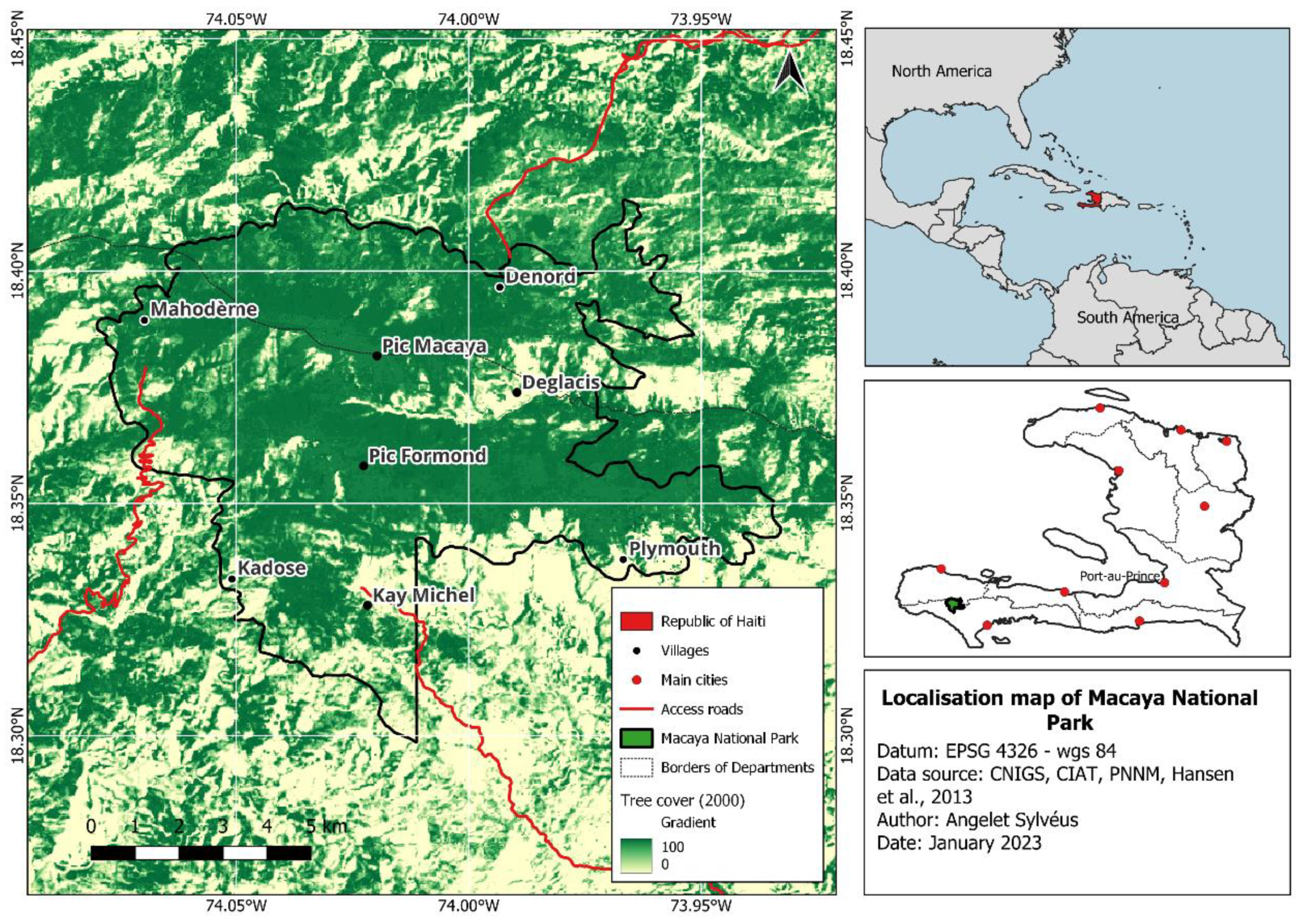
Figure 2.
Change in area covered by individual land cover class from 1985 to 2021 in Macaya National Park. There was an increase in 11.36% of the area covered by forest from the first through the last time-period. Most of this increase results from the regeneration of agricultural land that lost 75.34% of its area during the same time interval.
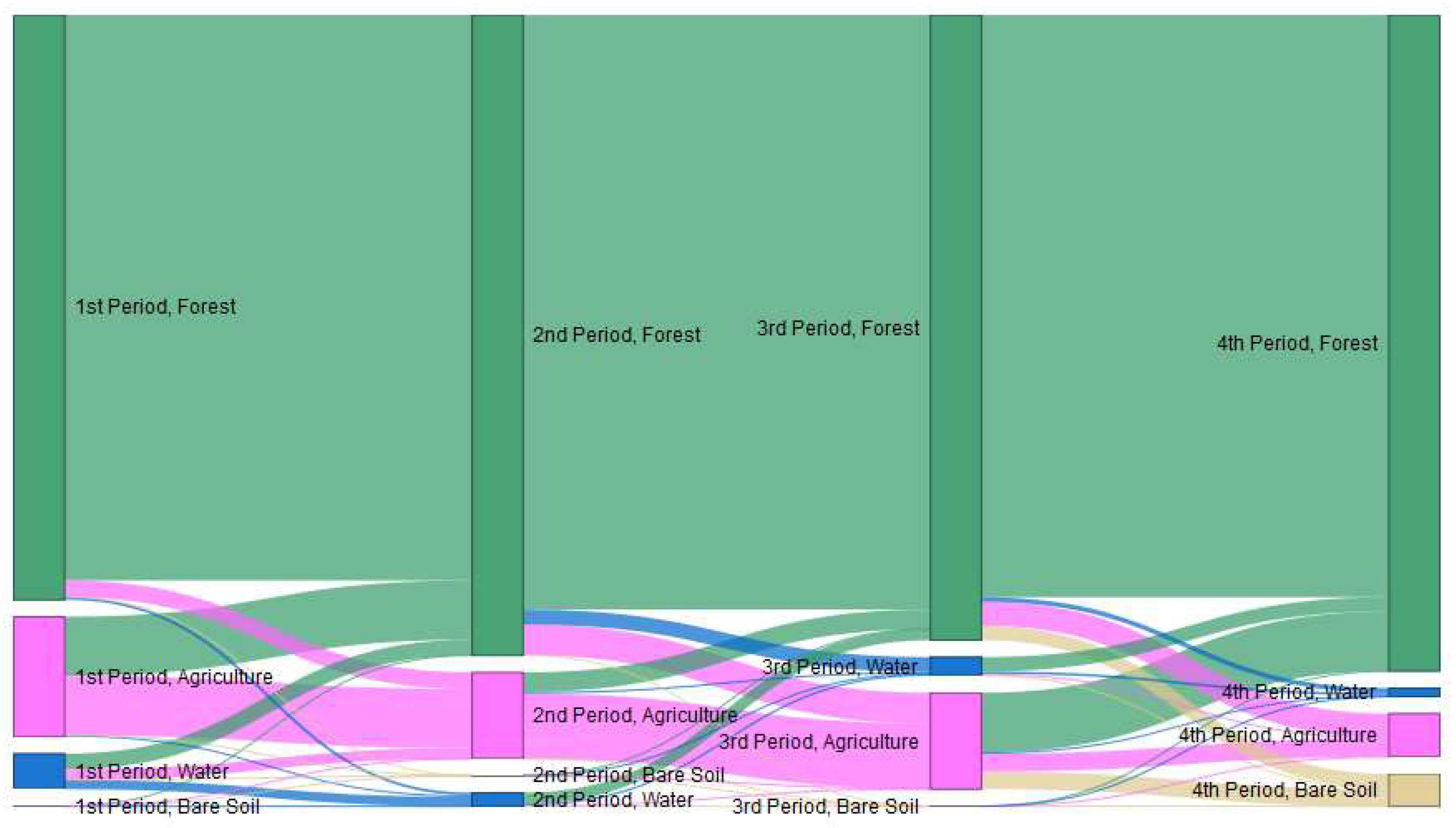
Figure 3.
Land-use changes (1985 – 2021) in relation to elevation (A) and slope (B) across the Macaya Natural Park. Blue circles indicate areas with major land-use changes. Black circles indicate areas remaining relatively stables, with low land-use changes.
Figure 3.
Land-use changes (1985 – 2021) in relation to elevation (A) and slope (B) across the Macaya Natural Park. Blue circles indicate areas with major land-use changes. Black circles indicate areas remaining relatively stables, with low land-use changes.
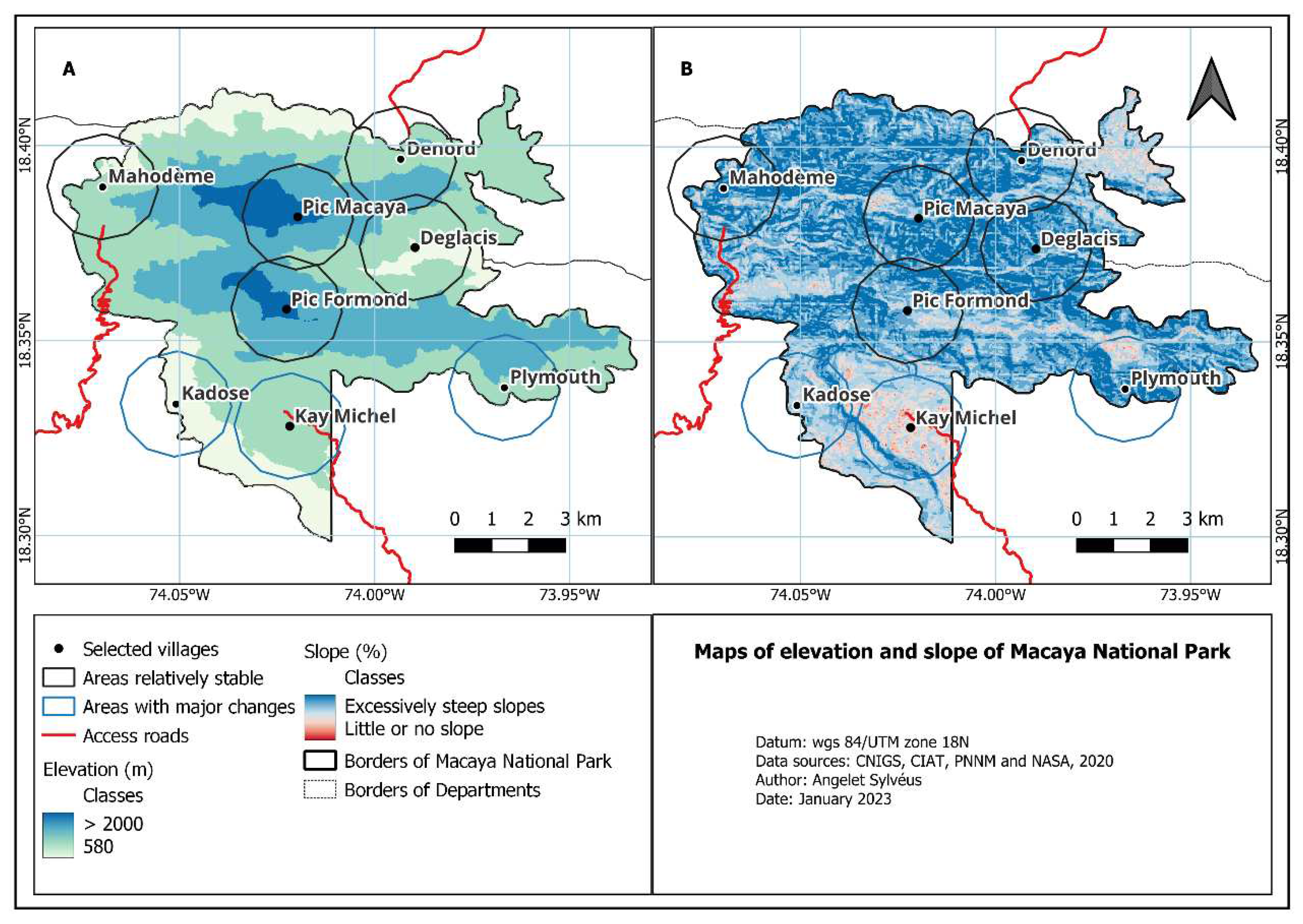

Table 1.
Major hurricanes that hit southern Haiti from 1985 through 2021. Category on the Saffir-Simpson hurricane wind scale. Sources: National Oceanic and Atmospheric Administration (NOAA) and Weather Undergroung.
Table 1.
Major hurricanes that hit southern Haiti from 1985 through 2021. Category on the Saffir-Simpson hurricane wind scale. Sources: National Oceanic and Atmospheric Administration (NOAA) and Weather Undergroung.
| Hurricane | Date | Category |
|---|---|---|
| Gilbert | September/88 | 5 |
| Georges | September/98 | 4 |
| Lili | September/02 | 4 |
| Ivan | September/04 | 5 |
| Dean | August/07 | 5 |
| Sandy | October/12 | 3 |
| Matthew | October/16 | 4 |
Disclaimer/Publisher’s Note: The statements, opinions and data contained in all publications are solely those of the individual author(s) and contributor(s) and not of MDPI and/or the editor(s). MDPI and/or the editor(s) disclaim responsibility for any injury to people or property resulting from any ideas, methods, instructions or products referred to in the content. |
© 2023 by the authors. Licensee MDPI, Basel, Switzerland. This article is an open access article distributed under the terms and conditions of the Creative Commons Attribution (CC BY) license (http://creativecommons.org/licenses/by/4.0/).
Copyright: This open access article is published under a Creative Commons CC BY 4.0 license, which permit the free download, distribution, and reuse, provided that the author and preprint are cited in any reuse.


