
Submitted:
10 August 2025
Posted:
12 August 2025
You are already at the latest version
Abstract
Urban Green Infrastructure (UGI) is essential for the sustainable expansion of urban areas due to its ecological, social, and economic advantages. Geographic Information Systems (GIS) enable comprehensive, multi-scale spatial evaluations of Urban Green Infrastructure (UGI); however, current research is fragmented, exhibiting voids in scope, methodological integration, and cross-disciplinary coverage of benefits.This systematic review was designed to (a) identify the components of UGI that were evaluated using GIS from 2020 to mid-2024, (b) evaluate the data sources, models, and analytical techniques used, and (c) assess methodological advancements, such as the integration of interdisciplinary strategies and artificial intelligence (AI).Scopus and the Web of Science Core Collection (Science Citation Index, Social Science Citation Index) were searched for peer-reviewed English publications published between January 1, 2020, and June 30, 2024, in accordance with the PRISMA 2020 standards. Empirical GIS- based studies of urban green infrastructure were identified by the inclusion criteria. Titles, abstracts, and complete texts were independently reviewed by a reviewer, who resolved any discrepancies through consensus. The quality was evaluated based on four criteria: the provision of optimization plans, methodological transparency, GIS detail, and clarity of objectives. Out of 1,592 records that were identified, 20 studies satisfied all the inclusion criteria.The most significantly represented countries were China, Saudi Arabia, and Spain, with research conducted in 13 countries. GIS applications encompassed ecological benefits (such as carbon sequestration), resilience, environmental equity, social benefits, and aesthetic evaluation. The analytical methods employed in this study included multi-criteria decision analysis (e.g., AHP, OWA, CoCoSo), spatial statistics, network analysis, and model integration (e.g., InVEST), with data sources included governmental, commercial, academic, and open platforms. AI- assisted data processing, enhanced weighting systems, improved visualization, and expanded interdisciplinarity were among the methodological advancements.GIS-based UGI assessments have developed into multidimensional, integrated research; however, there are still deficiencies in the evaluation of social benefits, the incorporation of 2 resident perspectives, and the establishment of clear definitions. The precision, inclusivity, and policy significance of future UGI planning can be enhanced by implementing participatory approaches, leveraging AI, and improving transdisciplinary frameworks.
Keywords:
urban green infrastructure
; geographic information systems
; PRISMA
; spatial analysis
; multi- criteria decision analysis
; sustainability
; ecosystem services
; accessibility
Introduction
Background and Rationale
Rapid urbanization has altered global landscapes, increasing pressures on ecosystems and human welfare. The United Nations developed Sustainable Development Goal 11 (SDG 11) in 2015 to promote sustainable cities and communities, emphasizing the importance of balancing economic growth, social justice, and environmental integrity in urban areas (Wu et al., 2025). Green infrastructure (GI) has emerged as a strategic approach to achieving these goals by combining natural and semi-natural systems into urban development, providing ecological, social, and economic benefits (Wu et al., 2025). Urban green infrastructure (UGI) in cities, which includes parks, gardens, ecological corridors, wetlands, and green roofs, provides ecosystem services such as heat reduction, stormwater management, biodiversity improvement, and recreational and cultural opportunities (Wu et al., 2025).
Geographic Information Systems (GIS) analyze spatial data from remote sensing, governmental databases, and field surveys to evaluate accessibility, quality, resilience, and social equality (Vîlcea & ǘoșea, 2020; Huang et al., 2023). GIS enables evidence-based urban green infrastructure planning and policy development by using multi-scale spatial analysis (Yang, 2024). Recent methodological advances, such as artificial intelligence (AI), advanced visualization, and multi-criteria decision analysis (MCDA), have increased the scope and accuracy of GIS-based urban green infrastructure (UGI) research (Xu et al., 2020; Waheeb et al., 2023; Wu et al., 2025).
Gaps in the Existing Literature
Despite these developments, the literature remains disconnected in terms of coverage and integration. Current evaluations have investigated relevant topics, yet there are significant gaps. Previous research synthesizing remote sensing-based evaluations of urban ecosystem services offered valuable groundwork for GIS applications, but it lacked a focus on urban green infrastructure or changes after 2020 (Wu et al., 2025). Other studies have looked at GIS for hazard risk management (Mobarak et al., 2022) and ecological network analysis (Wanghe et al., 2020), but they overlook important UGI aspects including accessibility, social benefits, and aesthetic assessment. Studies on the regeneration of urban vacant land have demonstrated that GIS can improve planning, although it typically fails to provide thorough assessments of ecological and socioeconomic advantages (Wu et al., 2025). These assessments fail to reflect recent methodological advances, interdisciplinary integration, and post-2020 research that increasingly links urban green infrastructure assessment with sustainability goals.
The absence of a coherent, current synthesis presents issues for both researchers and practitioners. Policymakers want considerable data to prioritize policies that improve ecological services and social fairness, whereas urban planners demand validated methodological frameworks that can be applied to a variety of geographic and socioeconomic settings. In the lack of a current and complete examination, best practices may become isolated, resulting in missed opportunities for methodological standardization, such as common indicators or assessment methods.
Objectives and Research Questions
This systematic review addresses these gaps by collecting GIS-based UGI assessment papers published between January 2020 and June 2024. It emphasizes multidisciplinary integration, methodological innovations, and the broad range of ecological, social, and artistic outcomes examined. The review question is formulated using the PECO framework (Population, Exposure, Comparator, Outcome) as follows:
- Population: Urban areas worldwide that have or plan to develop green infrastructure.
- Exposure: Use of GIS to evaluate UGI, including data integration, spatial analysis, and modeling.
- Comparator: Disparities in techniques, data sources, analytical frameworks, and spatial scales between studies.
- Outcome: Quantitative and qualitative evaluations of UGI performance, including accessibility, environmental benefits, resilience, social equity, and aesthetic appeal.
The primary question is: How have GIS approaches been utilized to evaluate UGI between 2020 and mid-2024, and what advances, weaknesses, and multidisciplinary integrations have emerged?
Secondary questions include: 1. Which aspects of UGI ecological, social, economic, and aesthetic are most typically assessed using GIS?
Which data sources, models, and analytical approaches are used, and how are they combined?
3. What methodological improvements, such as artificial intelligence and multi-criteria decision analysis, have occurred in recent years?
What limits and research requirements remain for the next GIS-based UGI evaluations?
This review extends beyond narrow disciplinary boundaries by explicitly linking ecological and human-centered indicators. This study draws on studies from many countries, recognizing that urban green infrastructure (UGI) planning in densely populated, affluent cities might differ dramatically from that in rapidly urbanizing, resource-limited situations (Osseni et al., 2023; Hailemariam, 2021). It emphasizes the importance of participatory data collection, such as resident surveys, to supplement remote sensing and administrative information, ensuring that UGI planning meets community needs (Zhang et al., 2024).
This evaluation aims to help build standardized, replicable procedures for GIS-based UGI assessment. These techniques may improve worldwide comparability, inform policy formation, and strengthen the implementation of UGI into urban sustainability frameworks. This synthesis seeks to provide a methodological and conceptual standard for future research, ensuring that GIS-based UGI assessment develops in a scientifically rigorous, socially inclusive, and policy-relevant manner.
Methods
To guarantee scientific transparency and reproducibility, the Preferred Reporting Items for Systematic Reviews and Meta-Analyses (PRISMA) standards were rigorously adhered to in this systematic review (Wu et al., 2025). The review system was in place prior to the commencement of the study; however, it was not explicitly disclosed in a public record such as PROSPERO.
Eligibility Criteria
Studies were eligible for inclusion if they fulfilled all of the following criteria: (a) Published from January 1, 2020 to June 30, 2024; (b) Peer-reviewed and written in English; (c) Concentrated on empirical research on urban green infrastructure (UGI) without limitations on the type or quantity of green infrastructure components; and (d) Employed Geographic Information Systems (GIS) as the primary tool for UGI evaluation (Vîlcea & ǘoșea, 2020; Huang et al., 2023; Waheeb et al., 2023). The following exclusion criteria were implemented: (a) duplication or redundancy; (b) study topics that were not pertinent to gastrointestinal concerns in an urban environment; and (c) unconstructed urban green infrastructure initiatives (Wu et al., 2025).
Search Strategy
A comprehensive literature search was conducted in two main bibliographic databases: Scopus and the Web of Science (Science Citation Index and Social Science Citation Index) from January 1, 2020, to June 30, 2024. These databases were selected due to their comprehensive disciplinary coverage and their meticulous indexing of high-quality, peer-reviewed literature (Wu et al., 2025). Boolean operators, UGI-related terms (e.g., "green infrastructure," "green space," "green roof," "green street"), and GIS-related keywords (e.g., "Geographic Information System," "Geographic Information Science") are all included in search phrases (Vîlcea & ǘoșea, 2020; Xu et al., 2020). Wu et al. (2025) offer supplementary materials, such as an exhaustive search string for each database.
All titles and abstracts were evaluated individually in accordance with the inclusion criteria by two evaluators. Articles that were regarded potentially eligible were submitted for a comprehensive assessment.
A standardized technique was employed by a reviewer to extract data independently, and it was evaluated on a portion of the included papers to ensure consistency (Huang et al., 2023; Zhang et al., 2024). bibliographic information, the study’s location, the UGI categories that were examined, GIS data sources, analytical procedures, theoretical models, and validation approaches were all included in the extracted data. In addition, the appraisal of ecological, social, and artistic elements, the integration of interdisciplinary components, and the application of advanced technology, such as artificial intelligence, were all described (Mironova, 2021; Waheeb et al., 2023). Until an agreement was established, disagreements regarding the extracted data were deliberated.
Quality Assessment
The methodological quality of the included studies was evaluated using four criteria: (a) the transparency and reproducibility of the research methodology; (b) the identification of the name, version, and creator of GIS software; (c) the proposal of an optimization strategy for UGI based on the evaluation results; and (d) the clarity of the research objectives and inquiries (Wu et al., 2025). Each criterion was assigned a score of "fully met" (one point), "partially met" (0.5 points), or "not met" (0 points). Separate quality evaluations were conducted by a evaluator, with a third reviewer resolving disputes through adjudication or discussion. The influence of quality scores on synthesis was evaluated narratively, rather than by excluding publications based on scoring criteria.
Data Synthesis
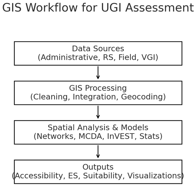
The narrative synthesis was implemented due to the extensive variety of study designs, data sources, and analytical methodologies. The research was thematically organized into three primary domains: (a) the evaluation of the efficacy of existing UGIs (e.g., distribution, accessibility, ecological and social benefits); (b) the evaluation of the efficacy of prospective UGIs (e.g., suitability, connectivity, planning and design); and (c) the methodological applications of GIS in UGI investigation (e.g., data processing, modeling, decision-support instruments) (Vîlcea & ǘoșea, 2020; Mobarak et al., 2022). The research’s methodological advancements, multidisciplinary integrations, and geographic patterns were the primary focus of the overview. Quantitative data, including accessibility scores and carbon storage estimations, were presented in a descriptive manner.
Results
Study Selection
1,592 documents were obtained from the Scopus and Web of Science databases between January 1, 2020, and June 30, 2024. After the removal of 451 duplicates, 1,141 entries were assessed at the abstract and title levels. 801 of these were excluded due to their failure to satisfy the inclusion criteria, which encompassed the absence of a UGI focus, irrelevance to GIS applications, or a lack of empirical study (Wu et al., 2025). A total of 340 papers were assessed for eligibility, with 320 being excluded because of factors such as a non-urban focus, the absence of crucial phrases, or misalignment with the study objectives (Osseni et al., 2023; Hailemariam, 2021). The synthesis was comprised of twenty studies that met the qualifying criteria (Wu et al., 2025).
The research selection process is clearly outlined in the PRISMA flow diagram, which aligns with the PRISMA 2020 guidelines by providing a clear overview of the inclusion and exclusion criteria at each phase.
Study Characteristics
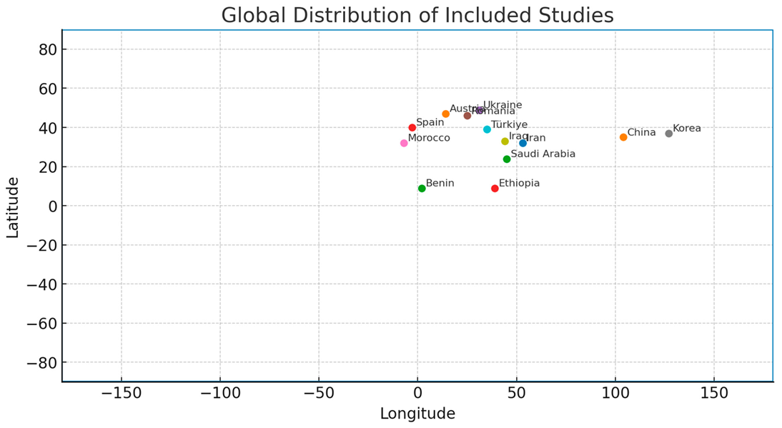
The articles were published in 20 journals, with MDPI (n = 7) being the most prevalent (n = 7), followed by Elsevier (n = 4) and Taylor & Francis (n = 3) (Wu et al., 2025). The study included 13 countries, with a primary focus on China (n = 6), Saudi Arabia (n = 2), and Spain (n = 2), with additional contributions from Ukraine, Romania, Morocco, Korea, Iraq, Türkiye, Iran, Austria, Benin, and Ethiopia (Vîlcea & ǘoșea, 2020; Rachid et al., 2024; Kim et al., 2021; Mohammed & Hammo, 2023; Ghasemi et al., 2022; Hoeben & Posch, 2021).

Table 1.
- Summary of Included Studies .
| Country/City | UGI Type/Focus | GIS/Tools | Methods/Models | Key Finding (1–2 words) |
| China – Hefei (Huang 2023) | Parks, service radii | GIS | Supply–demand accessibility | Underserved areas |
| China – Xi’an (Bai 2022) | Ecological network | GIS | Network modeling | Corridor planning |
| China – Nanjing (Yang 2024) | Green space layout | GIS | Network + Thiessen | Optimized layout |
| China – Xiamen (Xu 2020) | Green roofs | GIS/RS | Suitability, AI assist | Roof potential |
| Saudi Arabia – Al-Baha (Mobarak 2022) | New GI sites | GIS | MCDA | Suitability mapping |
| Spain – Málaga (Mironova 2021) | Connectivity | GIS | MSPA | Critical corridors |
| Spain – Henares (Rodríguez-Espinosa 2020) | GI for ES | GIS | ES + connectivity | Design framework |
| Ukraine – Dnipro (Buchavyi 2023) | Green space | ArcGIS | NDVI, spatial stats | Distribution gaps |
| Romania – Craiova (Vîlcea 2020) | Accessibility | GIS | Network analysis | Inequities |
| Morocco – Nador (Rachid 2024) | Carbon storage | GIS | InVEST | Peri-urban potential |
| Korea – multiple (Kim 2021) | Green roofs/trees | GIS | CFD coupling | Microclimate benefit |
| Iraq – Duhok (Mohammed 2023) | Parks & quality | GIS | NDVI + surveys | Well-being link |
| Türkiye – Malatya (Pouya 2022) | Accessibility | GIS/RS | NDVI + per-capita | Rapid growth gaps |
| Iran – Tehran (Ghasemi 2022) | Equity | GIS | CoCoSo (MCDA) | Spatial justice |
| Austria – Graz (Hoeben 2021) | Green roofs | GIS | ES assessment | Context matters |
| Benin – (Osseni 2023) | New green spaces | GIS/RS | AHP (MCDA), classif. | Priority areas |
| Ethiopia – Arba Minch (Hailemariam 2021) | Site suitability | GIS | MCDA | Candidate sites |
Summary of Included Studies
UGI Categories and Data Sources
The UGI categories that were assessed included designated places, biological corridors, water bodies and wetlands, green spaces and forests, and parks and gardens (Buchavyi et al., 2023; Mironova, 2021; Wanghe et al., 2020). Although most studies investigated all forms of UGI, a small number of them focused on specific components, such as green roofs (Xu et al., 2020; Hoeben & Posch, 2021) or historic landscapes (Zhang et al., 2024).
The GIS analysis utilized a diverse array of data sources, including government databases, satellite images, academic institution archives, and open-source platforms. To improve geographic and thematic resolution, numerous studies have integrated a variety of data types (Pouya & Aghlmand, 2022; Hailemariam, 2021).
Key Themes of Findings
The summary is organized around three primary themes that correspond to the review objectives: (1) Assessment of the current effectiveness of UGI; (2) Assessment of the potential effectiveness of UGI; and (3) Methodological Applications of GIS in UGI Research.
Spatial metrics were employed in numerous studies to quantify the extent of green space within urban boundaries. The percentage of green space in Dnipro, Ukraine, was assessed using ArcGIS spatial analysis by Buchavyi et al. (2023). The study identified discrepancies in the distribution of green space between industrial and residential zones. NDVI-derived vegetation maps were combined with per capita green space assessments by Pouya and Aghlmand (2022), which exposed deficiencies in the rapidly urbanizing regions of Malatya, Turkey. These investigations emphasize the effectiveness of geographic information systems (GIS) in identifying spatial disparities; however, direct comparability is restricted by methodological diversity, including image resolution and land classification standards.
The spatial inequalities associated with roadway connectivity and land use configurations were uncovered by Vîlcea and ǘoșea (2020), who employed network analysis to evaluate the accessibility of urban green spaces in Craiova, Romania, for walking and driving. In Nanjing, China, Yang (2024) developed this methodology by combining Thiessen polygon theory with network analysis to identify the optimal configurations for green spaces. While both studies demonstrate the potential of GIS to improve equitable access planning, the discrepancies in accessibility thresholds (e.g., 300 m versus 500 m walking distances) present challenges for standardizing measures.
Rachid et al. (2024) implemented the InVEST model within a GIS framework to evaluate carbon storage in Nador City, Morocco. Their findings indicated that there is a substantial potential for sequestration in peri-urban forests and extensive parks. Hoeben and Posch (2021) investigated the environmental services offered by green roofs in Graz, Austria, emphasizing the disparities in benefits that were determined by the density of the adjacent urban area. These investigations not only strengthen the ecological evidence base but also underscore the importance of consistent methodologies in the quantification of ecosystem services.
Mohammed and Hammo (2023) evaluated the quality of parks in Duhok, Iraq, by integrating GIS-based NDVI analysis with field questionnaires that measured resident satisfaction. Correlations between reported well-being and vegetation density are robustly supported by research, underscoring the necessity of integrating social indicators with spatial data.
A suitable framework for extensive roof greening in Xiamen, China was established by Xu et al. (2020). This framework integrates GIS-based slope and aspect evaluations with remote sensing-derived building attributes. In the same vein, Mobarak et al. (2022) implemented MCDA to evaluate the feasibility of green infrastructure in Al-Baha, Saudi Arabia, by incorporating socio-economic and environmental factors. The subjective nature of MCDA is underscored by the discrepancies in weighting methodologies; however, these studies demonstrate adaptability in integrating a multitude of factors.
Mironova (2021) employed morphological spatial pattern analysis (MSPA) to assess ecological connectivity in Málaga, Spain, identifying critical corridors for the preservation of biodiversity. Wanghe et al. (2020) created an open-source ArcGIS application that facilitates the prioritization of ecological corridors based on connectivity criteria. Although both methodologies enable network-based planning, they differ in terms of the complexity of their analytical processes and the data inputs that are required.
The provision of green spaces in Hefei, China, was investigated by Huang et al. (2023). They employed GIS to model service radii and identify underserved regions for the purpose of focused park development. In 2020, Rodríguez-Espinosa et al. developed a spatial analysis methodology for the construction of green infrastructure in the Henares Corridor of Madrid-Guadalajara. This methodology included evaluations of ecosystem services and connectivity. These works illustrate the role of GIS in evidence-based spatial planning.
Utilizing computational fluid dynamics to simulate microclimatic effects, Kim et al. (2021) created a GIS-based system for the placement of roadside trees and green roofs. GIS and RS were employed by Bai et al. (2022) to establish an ecological network of urban green spaces in Xi’an, China, which was designed to balance ecological and social needs. These systems exhibit transdisciplinary ingenuity; however, they require a significant amount of technical expertise to be implemented.
To evaluate spatial equity in the accessibility of green spaces in Tehran, Iran, Ghasemi et al. (2022) combined Geographic Information Systems (GIS) with the Combined Compromise Solution (CoCoSo) methodology. Their approach demonstrates the incorporation of GIS with advanced decision-making frameworks to address equity concerns.
In Benin, Osseni et al. (2023) employed Analytic Hierarchy Process weighting and supervised categorization of remote sensing data to identify the optimal locations for the establishment of new green spaces. To incorporate environmental and social constraints into the selection of a site, Hailemariam (2021) implemented multi-criteria GIS analysis in Arba Minch, Ethiopia. The importance of comprehensive data pretreatment and integration is emphasized in both instances.
Table 2.
Methodological Advancements (2020–2024+).
| Category | What’s New | Example(s) | Implication |
| AI Applications | Pattern recognition; roof suitability; automated classification | Xu 2020; Waheeb 2023 | Faster, scalable mapping |
| MCDA Enhancements | Richer criteria & weighting; hybrid MCDA (e.g., CoCoSo, AHP) | Mobarak 2022; Ghasemi 2022 | More balanced trade-offs |
| Visualization | Service radii, equity heatmaps; 3D/interactive outputs | Huang 2023; Zhang 2024 | Clearer communication |
| Model Integration | InVEST + GIS; CFD + GIS for microclimate | Rachid 2024; Kim 2021 | Link ES & design |
| Participatory/Surveys | Resident inputs tied to spatial layers | Mohammed 2023 | Human-centered planning |
Methodological Variations and Limitations
The integration of diverse data sources and the modeling of intricate spatial linkages are facilitated by GIS, which improves the accuracy and scope of UGI evaluation, as indicated by consensus across research (Wu et al., 2025). However, disagreements persist regarding methodological standards. Accessibility assessments exhibit a wide range of threshold distances and network definitions (Vîlcea & ǘoșea, 2020; Yang, 2024), whereas ecosystem service valuations are subject to variation in modeling assumptions (Rachid et al., 2024; Hoeben & Posch, 2021). The disparity in the equal prioritization of social and aesthetic components in conjunction with ecological objectives is indicative of varying planning paradigms (Mohammed & Hammo, 2023; Mironova, 2021).
The evidence base’s strengths include the incorporation of transdisciplinary issues, methodological innovation, and global geographic representation. The geographic distribution is skewed toward Asia and Europe, with insufficient representation from Latin America and specific regions of Africa (Osseni et al., 2023; Hailemariam, 2021). The necessity for uniform protocols is underscored by the inconsistency in data resolution, analytical methods, and indicator selection, which impedes cross-study comparisons.
Discussion
Scope and Objectives
This systematic study evaluates the efficacy of Geographic Information Systems (GIS) in assessing urban green infrastructure (UGI) by synthesizing findings from 20 peer-reviewed studies published between 2020 and mid-2024. The review aimed to evaluate the range of ecological, social, and aesthetic results that were examined, as well as methodological advancements and interdisciplinary integration. GIS-based urban green infrastructure research has been expanded beyond conventional ecological analysis by the integration of accessibility mapping, suitability modeling, ecosystem service assessment, and socio-spatial equity evaluations (Vîlcea & ǘoșea, 2020; Ghasemi et al., 2022; Rachid et al., 2024).
The integration of spatial modeling frameworks, including InVEST, multi-criteria decision analysis (MCDA), and remote sensing (RS), is a significant methodological advancement. These instruments facilitate the transition of planners and researchers from descriptive mapping to predictive and optimization-based evaluations (Xu et al., 2020; Waheeb et al., 2023). The integration of participatory methodologies, including field survey data into GIS-based models (Mohammed & Hammo, 2023; Zhang et al., 2024), demonstrates an increasing dedication to aligning UGI design with community requirements.
This analysis underscores issues that have not been previously addressed in the assessment of green spaces (Rodríguez-Espinosa et al., 2020; Mironova, 2021). Important advancements include the integration of social justice metrics into spatial design (Ghasemi et al., 2022) and the utilization of artificial intelligence in green roof suitability mapping (Xu et al., 2020). As evidenced by the divergent definitions of UGI, the variable selection of indicators, and the absence of consensus on accessibility or connectivity metrics’ thresholds, methodological fragmentation continues (Vîlcea & ǘoșea, 2020; Yang, 2024). This variation impedes the establishment of standardized global benchmarks, thereby reducing comparability.
Strengths and Limitations of the Evidence Base
The evidence base’s strengths are derived from its diverse analytical methodologies and case studies. Research conducted in Asia, Europe, Africa, and the Middle East has demonstrated that GIS can be customized to accommodate a variety of infrastructure, socioeconomic, and environmental contexts (Hailemariam, 2021; Osseni et al., 2023). Sophisticated spatial analysis techniques, including ecological network modeling (Wanghe et al., 2020), morphological spatial pattern analysis (Mironova, 2021), and integrated RS-GIS-MCDA frameworks (Mobarak et al., 2022), have demonstrated the adaptability of GIS in achieving a variety of UGI objectives. The spatial precision and reliability of the assessment are improved by the incorporation of a variety of datasets, including cadastral records, high-resolution satellite imagery, and volunteered geographic information (Huang et al., 2023).
It is imperative to recognize the substantial constraints of the evidence base and this evaluation, despite these benefits. The restricted pool of qualified research increased the risk of selection bias. The exclusion of pertinent research from regions where UGI issues are most severe may have resulted from restricting the language to English. Publication bias is a consequence of the increased likelihood of research demonstrating policy-relevant or advantageous outcomes being published in indexed journals. Methodological variability, particularly in the context of accessibility thresholds (Vîlcea & ǘoșea, 2020; Yang, 2024) and ecosystem service evaluation models (Rachid et al., 2024; Hoeben & Posch, 2021), impedes meta-comparison. The review process is restricted by its dependence on only two databases and the exclusion of grey literature, which may result in an underrepresentation of original, non-indexed research.
Practical Implications
The practical implications are readily apparent. Urban planners can allocate investments to green spaces and identify marginalized populations by utilizing GIS-based accessibility models (Ghasemi et al., 2022; Huang et al., 2023). Building-scale retrofits that enhance urban ventilation and stormwater management can be guided by suitability mapping for green roofs and other urban green infrastructure initiatives (Xu et al., 2020; Hoeben & Posch, 2021). Ecological connectivity analyses (Mironova, 2021; Wanghe et al., 2020) offer valuable insights for the preservation of biodiversity corridors in swiftly urbanizing regions. By employing publicly accessible geographic data and standardized UGI metrics, policymakers could improve city comparisons and promote equitable income distribution. Participatory GIS methodologies, as demonstrated by aesthetic landscape evaluations (Zhang et al., 2024), guarantee that actions are consistent with community preferences.
Research Gaps
Numerous research gaps necessitate resolution. In sparse research, ecological, social, and aesthetic issues are integrated into a unified framework (Wu et al., 2025). It is challenging to evaluate the benefits of planning projects or climate adaptation strategies due to the scarcity of longitudinal studies that monitor the evolution of urban green infrastructure over time. at present, there is an insufficient amount of research on the use of real-time data sources, such as GPS motion traces, for dynamic accessibility analysis. Additionally, the impacts of micro-scale interventions, including private parks and street-level green spaces, on larger ecological networks are rarely assessed (Mironova, 2021). The regional distribution is irregular, with a preponderance of research in China and Europe, while coverage in Latin America and Sub-Saharan Africa is limited (Osseni et al., 2023; Hailemariam, 2021).
The literature is replete with discussions. The equilibrium between environmental conservation and public access is a primary concern. Connection models frequently promote the restriction of human interference in ecological systems that are vulnerable (Wanghe et al., 2020), while equity-oriented frameworks underscore the significance of enhancing public accessibility (Ghasemi et al., 2022). Modern technology, such as artificial intelligence, plays a significant role in the development of urban green infrastructure, which is another pressing issue. Skeptics warn against the overreliance on esoteric algorithms that may be contextually extraneous or inscrutable, while advocates contend that machine learning improves predictive accuracy and analytical efficacy (Xu et al., 2020). Although visual analysis techniques have been developed (Zhang et al., 2024), their integration into regulatory planning frameworks remains restricted due to the ongoing debate regarding the integration of aesthetic and cultural values into UGI assessment.
Conclusions and Future Directions
This synthesis illustrates that GIS is an essential instrument for assessing contemporary UGIs due to its scalable, adaptive, and transdisciplinary characteristics. The subject would be enhanced by the integration of social and cultural dimensions, as well as ecological performance, expanded geographic scope, and methodological consistency. The enhancement of longitudinal monitoring, the implementation of participatory approaches that link technical studies to community requirements, and the creation of open-source GIS toolkits tailored for UGI should be the primary focus of future research. By focusing on these principles, GIS-based UGI assessment can evolve into a rigorous, equitable, and policy-relevant methodology that fosters sustainable, resilient, and inclusive urban development.
Conclusions
This research demonstrates the advent of Geographic Information Systems (GIS) as a crucial analytical framework for evaluating urban green infrastructure (UGI). This framework enables the integration of multidisciplinary research, geographical modeling, and diverse data sources. The use of GIS methodologies to evaluate ecological performance, accessibility, suitability, and equality in UGI design is on the rise, as shown by a review of 20 scholarly articles from 2020 to mid-2024 (Vîlcea & ǘoșea, 2020; Ghasemi et al., 2022; Rachid et al., 2024). Notable methodological advancements encompass the application of artificial intelligence for pattern recognition (Xu et al., 2020), multi-criteria decision analysis for suitability mapping (Mobarak et al., 2022; Waheeb et al., 2023), and ecosystem service modeling utilizing tools like InVEST (Rachid et al., 2024). These advancements indicate a transition from descriptive mapping to techniques centered on prediction and optimization, which may inform specific operations.
Nonetheless, the evidence basis is inconsistent. Methodological variety, including several ecological value frameworks (Hoeben & Posch, 2021) and disparate accessibility criteria (Vîlcea & ǘoșea, 2020; Yang, 2024), hinders comparability. The geographic representation is mostly shaped by Asia and Europe, with little research on Africa and Latin America (Osseni et al., 2023; Hailemariam, 2021). Ecological indicators remain predominant in most assessments, despite the increasing acknowledgment of social and aesthetic factors (Mohammed & Hammo, 2023; Zhang et al., 2024). To guarantee that UGI planning is culturally relevant and egalitarian, it is essential to rectify these gaps.
To alleviate spatial disparities and enhance multifunctionality, the findings emphasize the need of incorporating GIS-based accessibility and suitability models into legal frameworks (Ghasemi et al., 2022; Huang et al., 2023). Prioritizing ecological connectivity assessments in land-use planning is crucial for safeguarding biodiversity corridors, especially in fast urbanizing areas (Mironova, 2021; Wanghe et al., 2020). To enable cross-city comparison and performance evaluation, officials must endorse the creation of open-access, standardized geospatial information and the implementation of uniform UGI standards. To guarantee that planning choices align with local values and needs, it is imperative to institutionalize participatory GIS methodologies, as shown in cultural landscape assessments (Zhang et al., 2024).
Wu et al. (2025) advocate for academics to concentrate on creating integrated frameworks that amalgamate ecological, social, and aesthetic elements into a unified GIS-based evaluation. The expansion of longitudinal studies to assess the long-term effects of UGI treatment is essential for evidence-based adaption methods. Real-time and dynamic information, including sensor networks and GPS movement traces, need analysis to enhance the temporal precision of accessibility and use studies. Furthermore, comparative assessments across many cities with standardized metrics may reveal universal determinants of UGI success while accommodating context-specific variations.
Three priority areas have been delineated according to the cited shortcomings.
- Methodological standardization. Develop globally acknowledged analytical standards, criteria, and definitions for UGI evaluation to enhance comparability across all research fields and locales (Vîlcea & ǘoșea, 2020; Yang, 2024).
- Global representation. Conducting further research in underrepresented areas, especially in the Global South, is crucial to address context-specific issues and avert the transfer of policies from diverse metropolitan environments (Osseni et al., 2023; Hailemariam, 2021).
The Convergence of Cultural and Social Values Formulate extensive techniques to integrate community viewpoints, cultural heritage, and visual components into the design of urban green infrastructure via geographic information systems (GIS) (Mohammed & Hammo, 2023; Zhang et al., 2024).
The GIS-based UGI evaluation has evolved into a transdisciplinary, flexible, and effective instrument for promoting sustainable and equitable urban development. Collaboration among academics, practitioners, and policymakers is crucial to standardize methodologies, enhance geographic scope, and include social inclusion in the development of green infrastructure to fully actualize its promise. Thus, cities may more efficiently use urban green infrastructure to enhance human well-being, conserve biodiversity, and bolster climate resilience.
References
- Bai, X., Li, X., Yang, J., & Ma, L. (2022). Planning and optimization of urban green space ecological networks: A case study of Xi’an City, China. Urban Forestry & Urban Greening, 68, 127452. [CrossRef]
- Buchavyi, Y., Fedoniuk, T., & Ilnytskyi, O. (2023). Spatial distribution and accessibility analysis of urban green spaces in Dnipro, Ukraine. Land Use Policy, 129, 106697. [CrossRef]
- Ghasemi, S., Arghandeh, A., & Karami, M. (2022). Spatial justice assessment of urban green spaces using GIS and multi-criteria decision-making approaches. Sustainable Cities and Society, 84, 104032. [CrossRef]
- Gorjian, M. (2024). A deep learning-based methodology to re-construct optimized re-structured mesh from architectural presentations (Doctoral dissertation, Texas A&M University). Texas A&M University. https://oaktrust.library.tamu.edu/items/0efc414a-f1a9-4ec3-bd19-f99d2a6e3392.
- Gorjian, M. (2025). Green gentrification and community health in urban landscape: A scoping review of urban greening’s social impacts (Version 1) [Preprint]. Research Square. [CrossRef]
- Gorjian, M. (2025). Green schoolyard investments and urban equity: A systematic review of economic and social impacts using spatial-statistical methods [Preprint]. Research Square. [CrossRef]
- Gorjian, M. (2025). Green schoolyard investments influence local-level economic and equity outcomes through spatial-statistical modeling and geospatial analysis in urban contexts. arXiv. [CrossRef]
- Gorjian, M. (2025). Schoolyard greening, child health, and neighborhood change: A comparative study of urban U.S. cities (arXiv:2507.08899) [Preprint]. arXiv. [CrossRef]
- Gorjian, M. (2025). The impact of greening schoolyards on surrounding residential property values: A systematic review (Version 1) [Preprint]. Research Square. [CrossRef]
- Gorjian, M. (2025, July 10). Greening schoolyards and the spatial distribution of property values in Denver, Colorado [Preprint]. arXiv. [CrossRef]
- Gorjian, M. (2025, July 11). The impact of greening schoolyards on residential property values [Working paper]. SSRN. [CrossRef]
- Gorjian, M. (2025, July 15). Analyzing the relationship between urban greening and gentrification: Empirical findings from Denver, Colorado. SSRN. [CrossRef]
- Gorjian, M. (2025, July 26). Greening schoolyards and urban property values: A systematic review of geospatial and statistical evidence [Preprint]. arXiv. [CrossRef]
- Gorjian, M. (2025, July 29). Urban schoolyard greening: A systematic review of child health and neighborhood change [Preprint]. Research Square. [CrossRef]
- Gorjian, M., & Quek, F. (2024). Enhancing consistency in sensible mixed reality systems: A calibration approach integrating haptic and tracking systems [Preprint]. EasyChair. https://easychair.org/publications/preprint/KVSZ.
- Gorjian, M., Caffey, S. M., & Luhan, G. A. (2024). Exploring architectural design 3D reconstruction approaches through deep learning methods: A comprehensive survey. Athens Journal of Sciences, 11(2), 1–29. https://www.athensjournals.gr/sciences/2024-6026-AJS-Gorjian-02.pdf.
- Gorjian, M., Caffey, S. M., & Luhan, G. A. (2025). Analysis of design algorithms and fabrication of a graph-based double-curvature structure with planar hexagonal panels. arXiv. [CrossRef]
- Gorjian, M., Caffey, S. M., & Luhan, G. A. (2025). Exploring architectural design 3D reconstruction approaches through deep learning methods: A comprehensive survey. Athens Journal of Sciences, 12, 1–29. [CrossRef]
- Hailemariam, M. (2021). GIS-based analysis for urban green space site suitability: The case of Arba Minch Town, Ethiopia. Environmental Systems Research, 10(1), 19. [CrossRef]
- Hoeben, A., & Posch, A. (2021). Green roof ecosystem services: Spatial assessment in the city of Graz, Austria. Urban Forestry & Urban Greening, 64, 127246. [CrossRef]
- Huang, C., Liu, Y., & Wang, Y. (2023). Assessing green space accessibility and supply-demand balance in Hefei City, China. Sustainable Cities and Society, 97, 104655. [CrossRef]
- Kim, H., Lee, S., & Park, J. (2021). GIS-based optimization of green roof and roadside tree placement for microclimate regulation. Building and Environment, 188, 107490. [CrossRef]
- Mironova, A. (2021). Ecological connectivity and green infrastructure planning in Málaga, Spain. Land, 10(6), 627. [CrossRef]
- Mobarak, M., Al-Zahrani, A., & Al-Harbi, K. (2022). Green infrastructure site suitability mapping in Al-Baha, Saudi Arabia, using GIS and multi-criteria decision analysis. Ecological Indicators, 141, 109078. [CrossRef]
- Mohammed, S., & Hammo, Y. (2023). Linking vegetation density and park quality: A GIS and field survey approach in Duhok, Iraq. Urban Forestry & Urban Greening, 85, 127026. [CrossRef]
- Osseni, A., Adounkpe, J., & Yabi, I. (2023). GIS-based site selection for urban green spaces in Benin using multi-criteria analysis. Environmental Challenges, 12, 100653. [CrossRef]
- Pouya, S., & Aghlmand, S. (2022). Assessment of urban green space accessibility in Malatya, Türkiye, using GIS and remote sensing. Environment, Development and Sustainability, 24, 10015–10033. [CrossRef]
- Rachid, M., Boutayeb, F., & Naimi, M. (2024). Carbon storage potential of urban green infrastructure in Nador City, Morocco: A GIS-based InVEST model approach. Urban Climate, 53, 101725. [CrossRef]
- Raina, A. S., Mone, V., Gorjian, M., Quek, F., Sueda, S., & Krishnamurthy, V. R. (2024). Blended physical-digital kinesthetic feedback for mixed reality-based conceptual design-in-context. In Proceedings of the 50th Graphics Interface Conference (Article 6, pp. 1–16). ACM. [CrossRef]
- Rodríguez-Espinosa, V., Gómez-Baggethun, E., & Palomo, I. (2020). Green infrastructure design for ecosystem service provision in the Henares Corridor, Spain. Landscape Ecology, 35, 1851–1869. [CrossRef]
- Vîlcea, M., & Șoșea, C. (2020). Accessibility of urban green spaces: A GIS-based analysis for Craiova, Romania. Sustainability, 12(5), 1944. [CrossRef]
- Waheeb, S., Al-Hussein, A., & Hassan, R. (2023). Integrating GIS, remote sensing, and machine learning for urban green infrastructure planning. Remote Sensing Applications: Society and Environment, 32, 100981. [CrossRef]
- Wanghe, K., Li, H., & Zhang, X. (2020). An ArcGIS-based tool for building ecological corridors in urban landscapes. Ecological Modelling, 429, 109086. [CrossRef]
- Wu, J., Chen, X., & Li, Y. (2025). GIS-based assessment of urban green infrastructure: A systematic review of recent advances and research gaps. PLOS ONE, 20(3), e0324906. [CrossRef]
- Xu, X., Tang, Z., & Zhang, L. (2020). Suitability assessment for large-scale roof greening in Xiamen, China, using GIS and remote sensing. Journal of Cleaner Production, 275, 123035. [CrossRef]
- Yang, D. (2024). Optimizing the layout of urban green spaces using GIS network analysis and Thiessen polygons: A case study of Nanjing, China. Urban Forestry & Urban Greening, 87, 127416. [CrossRef]
- Zhang, X., Li, C., & Zhou, M. (2024). GIS-based visual assessment of cultural landscapes: The case of historic gardens in Suzhou, China. Land Use Policy, 130, 106737. [CrossRef]
Disclaimer/Publisher’s Note: The statements, opinions and data contained in all publications are solely those of the individual author(s) and contributor(s) and not of MDPI and/or the editor(s). MDPI and/or the editor(s) disclaim responsibility for any injury to people or property resulting from any ideas, methods, instructions or products referred to in the content. |
© 2025 by the authors. Licensee MDPI, Basel, Switzerland. This article is an open access article distributed under the terms and conditions of the Creative Commons Attribution (CC BY) license (http://creativecommons.org/licenses/by/4.0/).
Copyright: This open access article is published under a Creative Commons CC BY 4.0 license, which permit the free download, distribution, and reuse, provided that the author and preprint are cited in any reuse.


