Preprint
Article

This version is not peer-reviewed.

Suitable Habitat Prediction for African Wild Ass (Equus africanus) in the Danakil Desert of Afar Region, Ethiopia

A peer-reviewed article of this preprint also exists.

Submitted:

23 July 2025

Posted:

24 July 2025

You are already at the latest version

Abstract

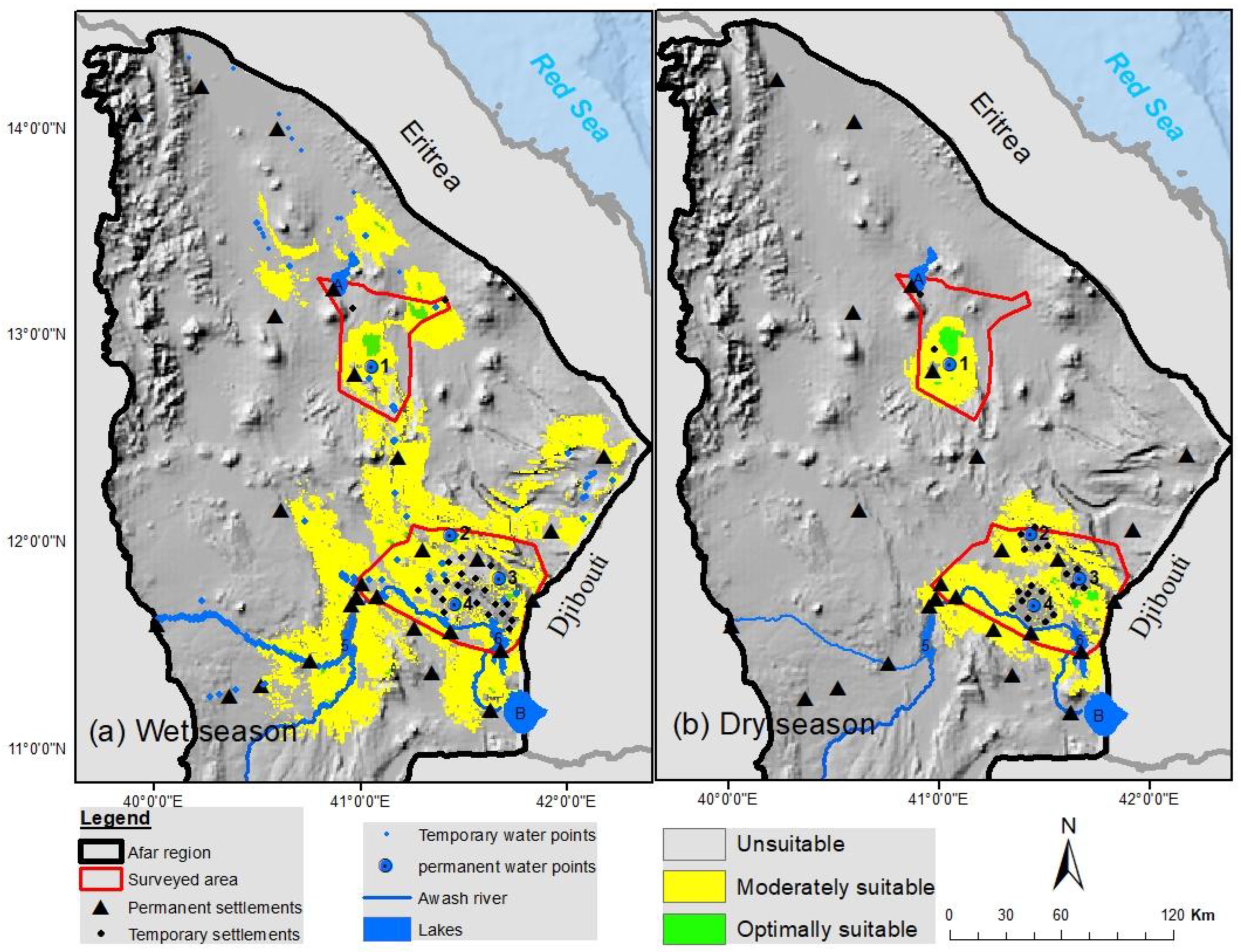
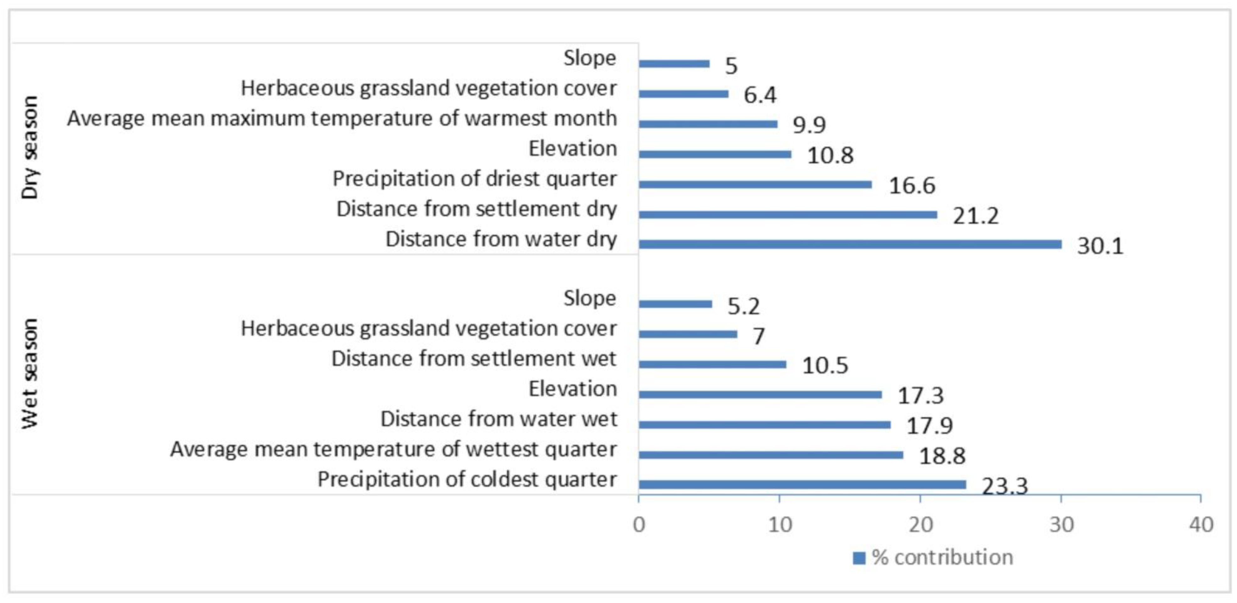
The Critically Endangered African wild ass are found in low population densities and there may be as few as 600 individuals in the Danakil Desert of Ethiopia and Eritrea. An understanding of suitable habitats is important for prioritizing the African wild ass conservation and management. In this study, maximum entropy (Maxent) modeling using African wild ass presence location data collected and separately prepared covariates to determine suitable habitat. The sample size (116 and 87) was determined by the number of occurrence points after removing duplicates for dry and wet seasons, respectively. The predicted moderately suitable habitat area extent was greater during the wet season (15,223 km2) than during the dry season (6,052 km2). Precipitation, temperature and distance from water sources were vital variables for the wet season while distance from water sources and distance from the settlements were important determinant covariates for the dry season. Model performances were high, with the area under the curve (AUC) values of 0.927 and 0.950 for wet and dry seasons, respectively. This information prioritizes where protected areas should be established for African wild ass conservation and also indicates potential new undocumented locations to guide surveys in the Danakil Desert of Afar Region, Ethiopia.

Keywords: 
;  ;  ;  ;  

1. Introduction

African wild ass (Equus africanus, Fitzinger, 1857) historically was distributed throughout north-eastern Africa (Egypt, Sudan, Eritrea, Ethiopia, Djibouti, and Somalia) and was relatively abundant in the early 1970s [1,2]. However, it is now the most endangered wild equid in the world [3]. Surveys in the 1990s and afterward indicate that the African wild ass range in Ethiopia and Eritrea has been reduced by approximately 90% and the remaining wild population is now mainly restricted to the Danakil Desert [4,5].
A major threat to the African wild ass in Ethiopia has been hunting for food and medicinal purposes [4,6]. Local pastoralists believed that diseases such as tuberculosis, backache, bone ache, constipation, and rheumatism can be cured by eating African wild ass meat and their bones in a soup [3]. This threat has been alleviated since 2002 due to a long term conservation endeavor in the area. Significant support was given by the late religious elder, Sultan Alimirah Hanfere, who made a declaration not to kill African wild ass or use any part of its body for medicinal purposes [7,8]. The attitude of local people changed, and since then, they have developed sympathy for its low population status and adopted a more positive attitude towards African wild ass conservation [9]. At this time, the main threats to the species are habitat loss and competition with livestock for access to drinking water and forage [3, 10&b]. Human activities and their livestock can negatively impact wildlife and their natural habitat by affecting the availability of resources and impacting the species’ activity, feeding, distribution, and habitat use [11,12]. The continued impact can result in habitat degradation and local extinction of some species [13].
Currently, the ranges of African wild ass in Ethiopia and Eritrea are occupied by human settlements and livestock [10&b, 14]. In Ethiopia, field surveys from 1994 to 2014 reported a significant reduction of African wild ass population (approximately 95%) and range (approximately 50%) since the 1970’s [3]. Their historical range was from Dire-Dawa to Yangudi-Rassa National Park and the Mille-Serdo Wild Ass Reserve [5] and surveys conducted by Kebede et al. (2014), reported that the African wild ass was extirpated from Yangudi-Rassa National Park.
Today the known range is very much reduced and restricted in the Afar Region from Serdo-Hillu in the south to Bidu-Afdera in the north. These two locales are 150 km apart and the movements and connectivity of these populations need to be investigated further [6] (Figure 1). Serdo-Hillu and Bidu-Afdera were the major areas selected for this study, since African wild ass still inhabit these areas [14]. Conservationists and wildlife managers require scientific information on the species, its natural habitats and extent of suitability to identify and determine where is appropriate to establish a protected area for securing conservation goals [15,16,17,18].
Species distribution models have been used to predict and identify suitable habitats for rare and cryptic wildlife species [19,20,21,22]. The Maximum Entropy (Maxent) model is one of the most widely used species distribution models [19,23,24]. The Maxent model uses the geographic coordinates of a species’ presence (e.g., observations, footprints, feces/droppings) and selected environmental variables to predict suitable habitat through probability spatially explicit model outputs [25,26,27,28]. Environmental covariates (e.g., precipitation, temperature, elevation, and slope) are used to infer the probability model of species’ potential suitable habitat [29,30,31,32,33]. Reliable and updated information on seasonal habitat requirements and species distribution is essential for conservation planning and species protection [34,35,36].
The main objective of this research was to predict the seasonal suitable habitat range of the critically endangered African wild ass, reassessing and refining upon the foundational work of Kebede et al., (2014). Moreover, this study looked in to a more illustrative suitable habitat determination considering larger dataset including factors of temporary water sources and impact of livestock displacement. In addition, this evidence will be used to strengthen the community based conservation strategy from socio ecological perspective. The Maxent model is employed to understand the potential range and guide future monitoring efforts to survey undocumented areas of the species occurrence. Additionally, the information will be used to determine what areas should be designated and protected for the long-term conservation of African wild ass and other wildlife species in the Danakil Desert of Afar Region, Ethiopia.

2. Materials and Methods
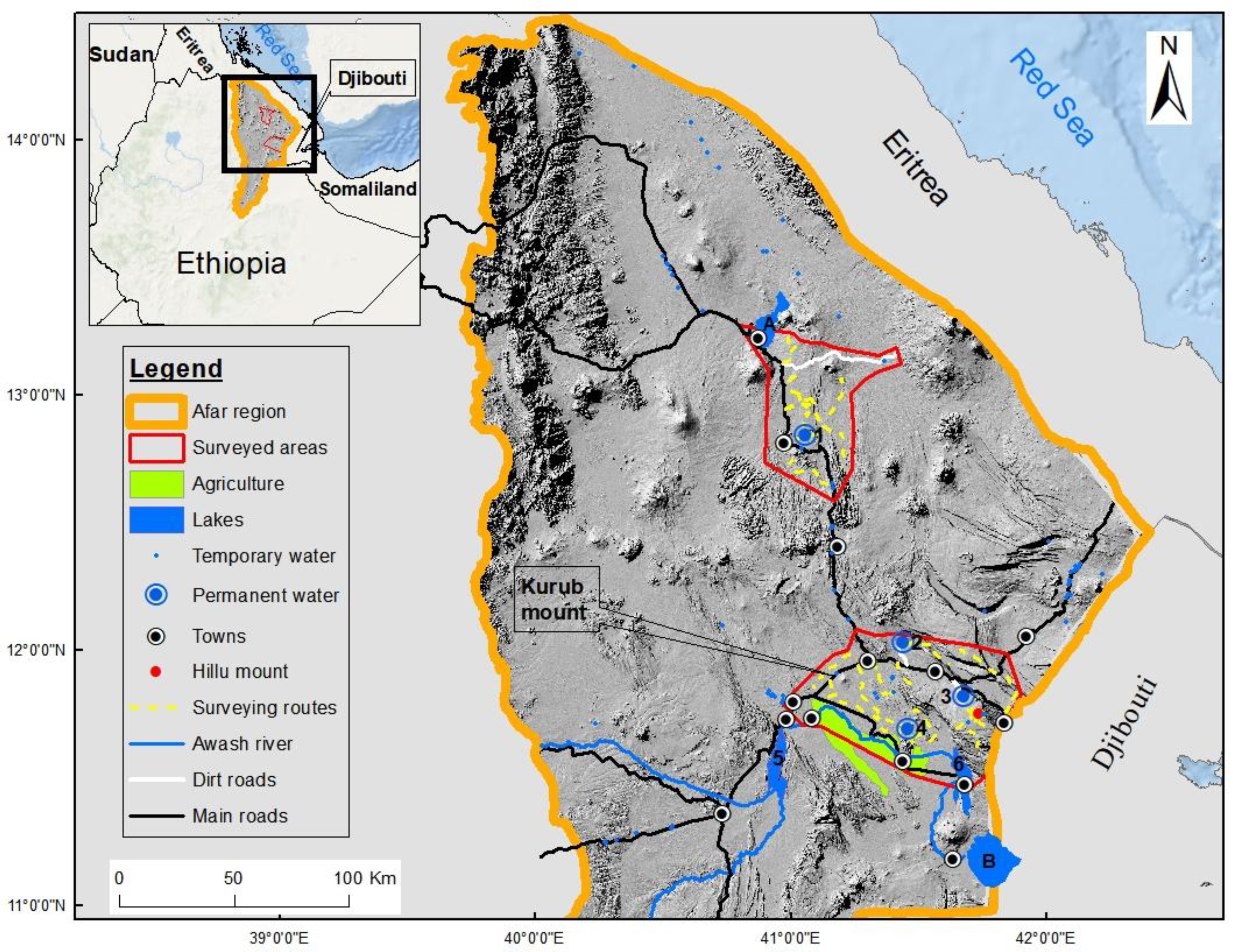
2.1. Study Area

This study was conducted in the Danakil Desert of northeastern Ethiopia, which is the hottest place on the African continent, and one of the hottest places in the world [37,38]. The area is characterized by an arid landscape with lava ridges [39,40]. The study area is located between 11˚45’20”–13˚05’40”N latitude and 40˚55’00”–41˚55’15”E longitude with an elevation ranging from c. 150 m below sea level in Bidu-Afdera up to c. 1,500 m above sea level on the MinkileBera in Serdo-Hillu [41]. The potential range of the African wild ass is estimated to be 95,000 km2 while the study area was 12,300 km2. We focused our survey in the defined area based on previous studies, known occurrences of African wild ass and local knowledge. The study area included two main survey sites, Bidu-Afdera and Serdo-Hillu. These sites were identified and delineated by Kebede et al., (2014) based on the frequent observation of African wild ass to these localities. These two surveyed areas constitute approximately 57 percent of the study area (12,300 km2) (Figure 1). There were six permanent water sources identified in the surveyed area (see Figure 1) that are potentially used by African wild ass. Andeley is one of the permanent water sources located in Bidu-Afdera which is critical for the survival of the species population occupying this area. The Bidu-Afdera survey site is located in the northern part with an elevation ranging between 150 m below sea level to 50 m above sea level and covers approximately 2,560 km2. The climate of the Bidu-Afdera area is extremely hot and dry with monthly mean maximum temperature of 43.6˚C during June. The monthly mean minimum temperature was 26.9˚C in January. The monthly mean rainfall of this site ranged between 0.1 mm in February to 34.9 mm in August. The Serdo-Hillu survey site is located in the southern part with an elevation ranging from 393 to 1,045 m above sea level and covers an area of 4,473 km2. The monthly mean maximum temperature was 42.5˚C in June whereas the monthly mean minimum temperature was 17.5˚C in December. The monthly mean rainfall of this area ranged between a low of 0.6 mm in December and January to a high of 40.8 mm from mid-June to August [42].

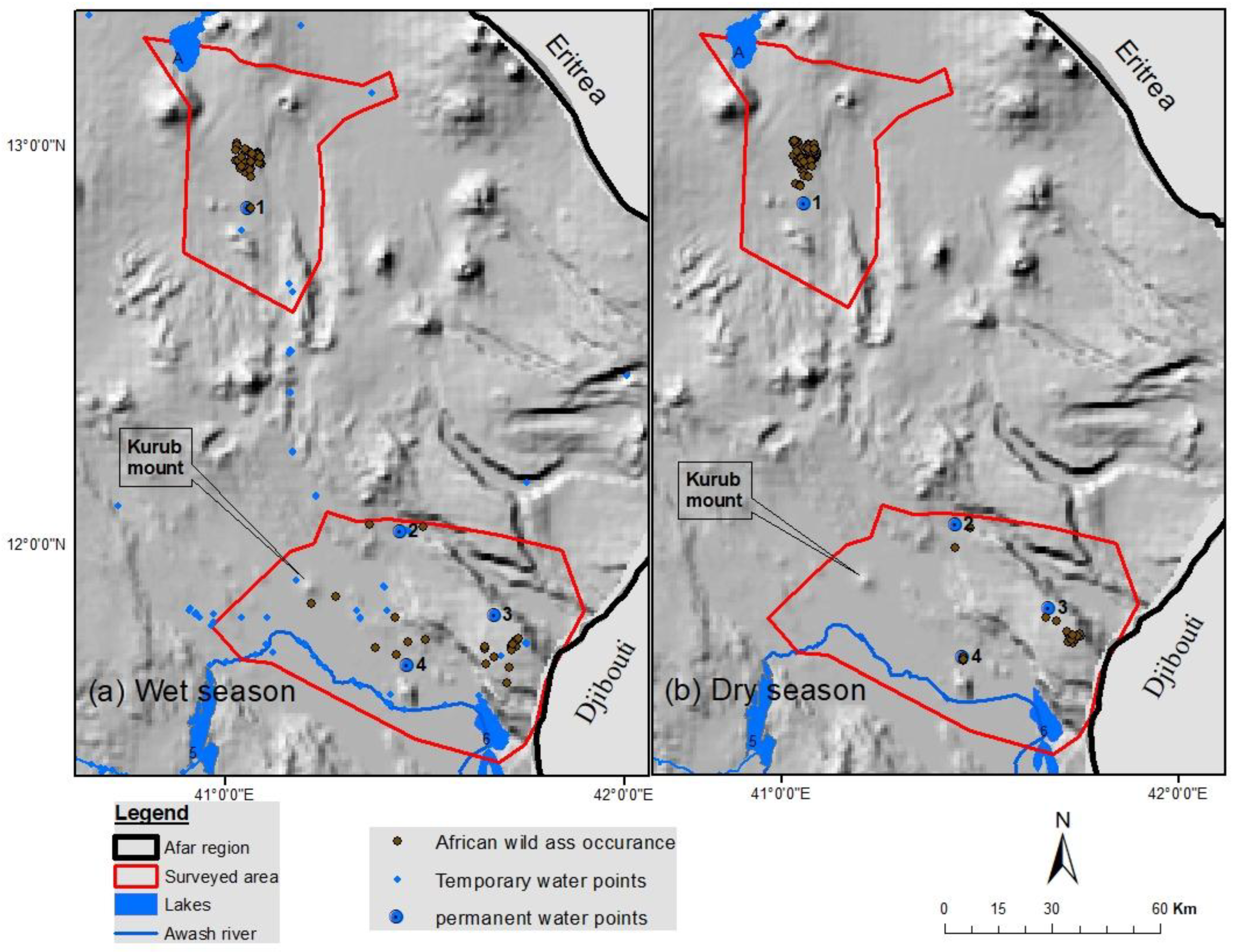
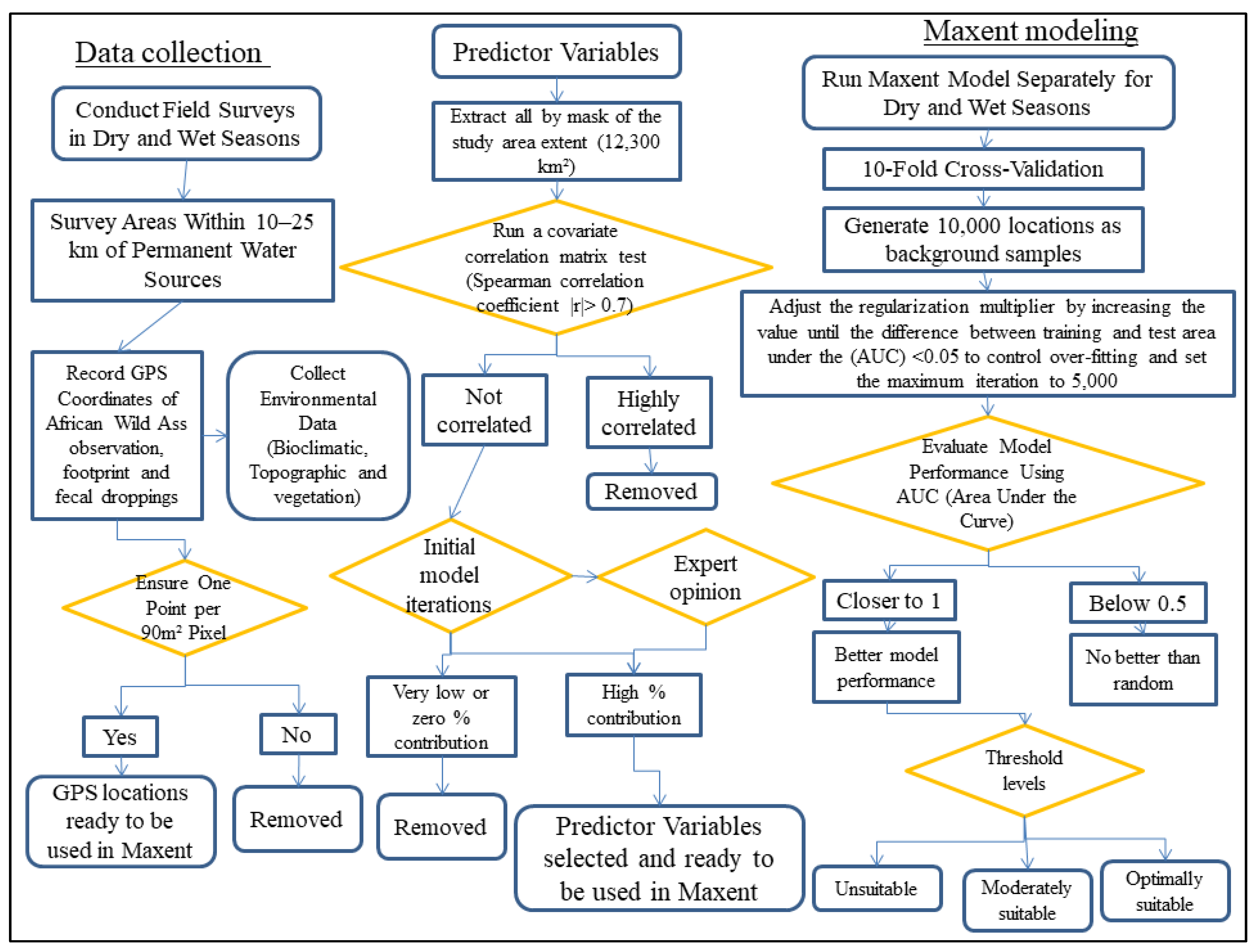
2.2. Data Collection

Collecting data on African wild ass was demanding due to the harsh arid climate and rugged terrain of the study area [43]. African wild ass in the Danakil Desert occur in very low density with scattered small isolated groups which makes it impractical to use conventional methods of data collection like line transects [7,10,44]. Some of the areas could be surveyed using a 4-wheel drive vehicle. However, most of the area was not accessible to vehicles. As a result most of the fieldwork was conducted on foot using survey routes that made it possible to scan hilltops, water points, valleys and gorges (Figure 1) [45,46]. These foot survey routes cover 963 kilometers (279 kilometers in Bidu-Afdera, and 684 kilometers in Serdo-Hillu) during the survey periods of 126 days, quarterly for two consecutive years. The presence of African wild ass was documented based on direct observations (within a radius of 1000 m and sometimes can be approached up to 400 m after slow habituation), footprints, and fecal droppings (distinguished by their bigger size and patterns) [47], and these points were recorded with a global positioning system (GPS) [34]. Data were collected every three months for at least seven days at each site from December 2017 through February 2020. Surveys were usually carried out when African wild asses were most active, i.e., in the morning from 06:00 to 11:00 hours and in the late afternoon from 15:00 to 18:00 hours. Surveys documented data on the presence of African wild ass (seen, camera trapped, foot print or droppings), and settlements (permanent or temporary), livestock and all permanent and temporary water sources. Then, all coordinates for presence data were combined for the data analysis using Maxent. In total, we collected 411 GPS locations of African wild ass of which 242 were for the dry seasons and 169 were for the wet seasons. We limited occurrence records to a single point for each single 90 m2 pixel so that each pixel would represent an occurrence point to avoid weighting. This reduced the number of recorded occurrence points from (242 and 169) to (116 and 87) for dry and wet seasons, respectively (Figure 2).

2.3. Predictor Variables

The selection of predictor variables is a fundamental step that can impact the quality and usefulness of habitat suitability models [48]. Predictor variables selections were based on expert opinion with emphasis on the spatial conducive or limiting conditions to African wild ass distribution in the Danakil [49]. We used 19 bioclimatic variables from CHELSA climate database (www.chelsa-climate.org) (Table 1), land cover type (tree cover, shrub cover, herbaceous grassland, cropland, bare ground areas, and built-up areas) and topographic variables (elevation, aspect, and slope) from the European Space Agency (ESA) World Cover (https://esa-worldcover.org). User generated distance from water and distance from settlements have been used as additional predictor variables. These variables were produced for wet and dry seasons separately using the Euclidian distance tool in ArcGIS v. 10.8 [50] (Table 2). We resampled all the predictor variables at the resolution of 90 m using the resample tool in Arc map aligning with the species ecology and the amount of occurrence data to avoid over-fitting so as to improve the identification of suitable habitat for African wild ass using Maxent modeling. Finally, we calculated the 20-years mean (2000 – 2019) of the enhanced vegetation index in Google Earth Engine [51]. We selected major predictor variables that could influence the distribution of African wild ass in the Danakil Desert and had higher percent of contribution on the initial model iterations after we ran a covariate correlation matrix test for each datasets (bioclimatic and environmental variables) and developed the model by removing one of each pair of highly correlated predictor variables (Spearman correlation coefficient |r|> 0.7) [52].
Consequently, seven predictor variables (precipitation i.e., average mean precipitation of coldest quarter for the wet season, average mean precipitation of driest quarter for the dry season, temperature i.e., average mean temperature of wettest quarter for wet season, average mean maximum temperature of warmest month for dry season, herbaceous grassland cover, elevation, slope, distance from water and distance from settlements) were selected for the model. Precipitation is an important source of water and essential for the growth of forage (grasses and herbs) which plays a fundamental role for the survival of the species in arid environment like the Danakil [53,54,55,56]. Climatic variables (average mean precipitation of coldest quarter for the wet season, average mean precipitation of driest quarter for the dry season) were selected based on their high contributions and low co-linearity. Even though the vegetation cover of the study area is sparse, the herbaceous grassland cover is an important determinant factor indicating forage availability for African wild ass, other wildlife and livestock [57,58,59].
Average mean temperature of wettest quarter for wet season, average mean maximum temperature of warmest month for dry season, elevation, and slope were assumed important due to their level of influence on the species distribution in the surveyed area. The other determinant covariates were distance variables classified as distance from water which are a critical resource for the survival of African wild ass. Permanent water points can persist throughout the year whereas temporary water points (ponds) only stay few months after the rain. All pertinent information on temporary water points was collected for the wet season during the wet season survey (March-August). The rainwater may sometimes persist longer after the rain and attract the species to utilize larger areas compared to the dry season. As Danakil is a very arid environment, and there are only a few known permanent water points, it was not difficult to monitor available water sources in the survey area. Distances from permanent and temporary settlements were also categorized as wet and dry seasons which are an important covariate as the distribution and movement of African wild ass is negatively influenced by people and settlements. Permanent settlements include towns, highways and roads whereas temporary settlements were villages that persisted for less than six months. These village huts locally called as “Ribora Afar Ari” that can be assembled easily at destination point during mobility and dismantled quickly and moved to areas of better grazing site for livestock.

2.4. Data Analysis

The maximum entropy model (Maxent) is an established and frequently used tool to predict suitable habitat of a given species [60]. The model has been shown to perform well with small datasets using presence-only data [25]. Habitat suitability for African wild ass was modeled using Maxent version 3.4.4 with 10 replicates of selected variables using k-fold cross-validation for the dry and wet seasons which withholds 10% of the data for testing in each iteration and results are averaged across all iterations. We used the default value of 10,000 locations to generate background samples from the surveyed areas within the study area making sure these areas were accessible and represented the available environment [61]. The default (10,000) value was used considering our vast study area as these background points provide sufficient coverage for the large environmental variability of the Danakil. Also using a finer resolution (90 m) of predictor variables can help to capture the complex environmental conditions (e.g., mountainous terrain and diverse vegetation) [49,62] (Figure 3).
Model results were evaluated by AUC (area under the receiver operating characteristics (ROC) curve) values, which are automatically generated by Maxent [63]. The AUC value provides a measure of model performance with a range from 0 to 1 with a values closer to 1 indicating better model performance and values at or below 0.5 are no better than random [24,25]. We adjusted the regularization multiplier by increasing the value until the difference between training and test area under the receiver operating characteristics curve (AUC) <0.05 to control over-fitting and set the maximum iteration to 5,000 [64]. The model output was reclassified into unsuitable, moderately suitable, and optimally suitable based on the minimum training presence logistic threshold and maximum test sensitivity plus specificity logistic threshold, i.e., pixel values lower than minimum were considered as unsuitable, pixel values between minimum and maximum were considered as moderately suitable, and pixel values higher than maximum were considered as optimally suitable.
The model result figure was constructed by reclassifying model output in Arc map toolsets based on the minimum and maximum threshold values [65]. The suitable and optimal areas were combined to determine and quantify the extent of suitable habitat for African wild ass (Figure 4). Based on the number of occurrence points, we included seven variables in the models following the recommendation to use no more than one predictor for every 10 occurrence points [61]. All the other area and distance calculations as well as figures were constructed and all predictor variables were projected to the WGS84 UTM zone 37N and clipped to the extent of the Afar Region with a resolution of 90 m using ArcGIS version 10.8 [50].

3. Results

Maxent model results showed average test AUC values of 0.927 and 0.950 for wet and dry seasons, respectively. The minimum training presence logistic threshold and maximum test sensitivity plus specificity logistic threshold values were 0.008 and 0.437 for the wet season and 0.005 and 0.273 for the dry season. The model results of habitat suitability indicated that there is a difference in size of suitable habitat for the African wild ass between seasons. The extent of suitable (moderately suitable and optimally suitable) habitat for the wet season was 15,517 km2 where as for the dry season was 6,259 km2, this result indicated that the wet season suitable habitat is much bigger (more than two-fold) compared with the dry season. Similarly, the size of optimum habitat for the wet season (294 km2) showed 87 km2 increase compared with dry season (207 km2), this indicated that the prevalence of more grassland vegetation cover during wet season due to moisture availability (Figure 4).
Distance from water, distance from settlement, and precipitation of driest quarter were the most important predictor variables showing the highest percentage contribution during the dry season (Figure 5). Whereas, in the wet season, precipitation of coldest quarter, mean temperature of wettest quarter, and distance from water scored a higher percentage contribution. Conversely, herbaceous cover and slope scored a lower percentage contribution to both seasons modeling (Figure 5).

4. Discussion

The habitat suitability model results for the African wild ass (Equus africanus) achieved strong predictive performance, with AUC values of 0.927 and 0.950 for the wet and dry seasons, respectively. These high AUC values are a promising sign of effectiveness of the models to predict the extent of suitable habitat for a species under study [66]. The results revealed significant seasonal variations between wet and dry seasons, emphasizing the complex interplay between environmental variables and species response in arid environments of Danakil Depression. The model analysis also reflected the dynamic nature of African wild ass habitat selection driven mainly by environmental conditions. The model result indicated that African wild ass has more suitable areas and a greater potential distribution range during the wet season compared to the dry season (Figure 4). This is possibly due to widely available water points and forage in the wet season [14,67]. The wet season suitable habitat covered a total of 15,517 km² which is significantly larger than the 6,259 km² of the dry season. This is a typical feature of arid environment which happened due to rain water availability allowing vegetation cover increase during the wet season [68]. This situation allows the species to expand the range and occupy bigger area. Similar seasonal expansion was observed by Tesfai et al. (2023), in Eritrea. This seasonal shift underscores the critical importance of water availability and precipitation in determining habitat use.
The model showed the importance of environmental variables in determining habitat suitability variability between seasons. During the dry season, distance from water was the most important predictor variable. This finding aligns with previous studies. As Klingel (1972) noted, the African wild ass often congregates around water points during the dry season, which is a focal area for survival and emphasizes the importance of permanent water sources in arid landscapes [14,67]. Water sources are scarce during dry seasons and permanent water is critical for survival. Even though African wild ass are physiologically well adapted to arid ecosystems, they still need access to surface water [4]. Adult males and non-reproductive females can drink at five day intervals, but adult females with foals drink daily [10]. The African wild ass in the Serdo-Hillu area have better access to water compared to Bidu-Afdera area, because the water sources Edgilo, Aila Manda and Lake Gamary are in close proximity (10-25 km) of their location [14]. Water dependent species like the African wild ass are known to be constrained by proximity to water during dry periods when surface water becomes scarce, influencing their spatial distribution [69]. Despite this seasonal contraction in overall suitable habitat, the area of optimum habitat did not show huge difference between seasons (294 km² in the wet season and 207 km² in the dry season). This suggests that core areas may remain optimally suitable for the species throughout the year. These areas likely represent critical refugee for the species due to availability of critical resources to support the species during both seasons.
In the wet season, precipitation in the coldest quarter, average mean temperature of the wettest quarter, and distance from water became the dominant variables. Rainfall during the wet season reduces the dependency of the species on permanent water sources since temporary water sources allow African wild ass to disperse more widely [70]. The high percent of contribution for climatic variables, such as precipitation and temperature, reflect the direct influence of these factors on forage production creating favorable situation during the wet season (Figure 5) [56]. During this period, African wild ass were observed closer (2-3 km) to temporary water sources where forage and water were available (R. Mohammed, pers. Obs, 2020). This temporary water holes dug by the Afar Region tourism office, supply water to the community, livestock, and wildlife, including African wild ass that helps to reduce competition for water.
Distance from human settlements plays a crucial role, as African wild ass tend to avoid areas with high human and livestock densities possibly due to the risks of hunting and competition for resources [67]. Distance from the settlement had a lower contribution during the wet season. This may indicate that competition for water and forage is reduced as there is more wide spread availability of water and forage so that African wild ass maintain their distance (1-2 km) from livestock and (3-6 km) from local settlements (Figure 4a). Pastoralists and their livestock also utilize areas that African wild ass inhabit [2], and may compete for forage as well as water [10&b]. Competition for water is high when people and livestock are more concentrated around the permanent water sites in the dry season [4,71]. The important contribution that distance from settlements makes in our dry season model indicates more competition with livestock for water as also reported in other studies (Figure 4b) [67]. The prevalence of more water and forage could attract livestock and increase the competition during wet season, which may lead to smaller optimum habitat for seasonal modeling [72,73]. Compared to the above predictor variables, (e.g., distance from water, precipitation, and distance from settlement) herbaceous grassland cover and slop contributed minimum in both seasons. This relative minimal contribution could be due to the nature of scarce vegetation cover in the Danakil and species ability to move across rugged terrain whenever required (Figure 5). This result is consistent with findings by Kebede et al. (2014), who also found that topography and vegetation type were less significant compared to water availability and human presence. The African wild ass is highly adaptable to various terrain types and can thrive in open plains or rugged terrain as long as water and forage are accessible [71]. Their ability to use a wide range of habitats due to physiological adaptation allows them to persist in a very arid ecosystem, such as the Danakil Depression [74,75].
The optimum habitat sizes of this study in wet and dry seasons are very small compared to the previous finding by Kebede et al., (2014). This might be due to the growing number of settlements over time and the recent expansion of agricultural developments in the area (Aiela Manda, and Lake Gamary). This expansion of mechanized agriculture and recent mining activity in the south near the permanent water location Aila Manda and Lake Gamary pose a potential threat to African wild ass in particular and for all wildlife in general. The northern study area is less susceptible to human activities due to inhospitable environmental factors such as high temperature, poor forage cover and scarcity of permanent water.
The seasonal variations in habitat suitability highlighted by this study have profound implications through better understanding of the species habitat utilization in different seasons and enable to delineate the boundary where to conserve the fragmented population and their habitats. The contraction of suitable habitats during the dry season means that the species is likely more vulnerable during this period, particularly as human and livestock activities intensify around remaining water sources. Tesfai et al. (2023) similarly emphasized the need for targeted conservation efforts during the dry season when competition for resources is highest. One critical conservation strategy would be the protection of key water sources and surrounding optimally suitable habitats, especially those that remain suitable year-round through community based conservation approaches. As indicated by other studies [14,67], the areas around permanent water sources represent core habitats that are crucial for the survival of the African wild ass. Following the current model prediction, effective management of these areas, including the reduction of human-wildlife conflict and the establishment of protected areas, could significantly enhance the African wild ass chances of survival and generate livelihood options benefiting locals.
Climate change affects the critically endangered African wild ass in the arid and semi-arid regions of the Danakil Desert, Ethiopia [14,76]. High temperatures, prolonged droughts, and erratic rainfall patterns are expected to exacerbate water scarcity and reduce forage availability, further fragmenting the species limited habitat [77]. As a result of these climate shifts, the wild ass may have to change its seasonal movement patterns and how it uses its habitat. Long-term habitat stability is crucial for the survival of the African wild ass, as the species relies on specific environmental conditions, such as proximity to permanent water sources and suitable forage [3]. However, climate change may disrupt these conditions, leading to habitat degradation and reduced suitability over time. For instance, prolonged droughts could dry up seasonal water sources, while increased temperatures might reduce the productivity of sparse vegetation [14]. To mitigate these impacts, conservation strategies must prioritize the protection of key habitats, such as areas near permanent water sources, and incorporate climate changes into management plans.
The main limitation of the study is collecting actual presence data due to the difficulty to access the species habitat. Also detecting African wild ass was another constraint due to its shy behavior [78]. To alleviate this, we walked through gorges and hill tops to record occurrence. The other limitation is may be the potential for model bias due to the reliance on presence-only data, which may not fully capture the African wild ass true distribution, especially in areas where the species is rare or difficult to detect [79]. We decreased such effect by careful selection of background data, incorporating relevant predictors and model calibration by using cross-validation to assess model performance. Additionally, the accuracy of predictor variables may be limited by the resolution of remote sensing data [80]. To minimize this kind of noise effect at such fine scale, we have aligned the environmental data with the species actual habitat use.

5. Conclusions

The Maxent model prediction results demonstrate the African wild ass suitable habitat depends on water availability and climatic factors, which vary significantly between wet and dry seasons. These prediction results indicate that African wild ass could have more spatially distributed suitable habitat during the wet than the dry season as water and forage are widely available. The stability of optimal habitats across seasons and the importance of water sources underscore the need for focused conservation efforts in key areas, particularly during the dry season. The differences that distance from settlement played in wet and dry season models suggest that African wild ass are less affected by settlements when resources are available, while dry season models indicate they might compete for available forage and water resources with people and livestock. This research indicates that there are undocumented potential suitable areas that need to be surveyed. The extent of suitable habitat during the wet season indicates that the Bidu and Serdo survey areas are not fragmented and that African wild ass should be able to move freely between these locales. The observed patterns of habitat use could provide insights applicable to other species facing similar ecological challenges. This research underlines the importance of integrating species-specific adaptations into conservation planning, particularly in regions where there are environmental extremes. Additionally, conservation management measures like rangeland management to improve pasture condition and promoting and creating local people and wildlife co-existence would have a meaningful outcome. Further research would provide needed information on the African wild ass population size and management of available suitable habitat through prioritizing which areas should be designated as protected habitat for the critically endangered African wild ass.

Supplementary Materials

The following supporting information can be downloaded at: .

Author Contributions

Redwan Mohammed Yimer: Conceptualization, Data curation, Formal Analysis, Investigation, Methodology, Software, Supervision, Validation, Visualization, Writing – original draft, Writing – review & editing. Redae Teclai Tesfai: Conceptualization, Formal Analysis, Investigation, Methodology, Software, Supervision, Validation, Visualization, Writing – review & editing. Patricia D Moehlman: Conceptualization, Formal Analysis, Funding acquisition, Investigation, Methodology, Project administration, Resources, Supervision, Validation, Writing – review & editing. Paul H Evangelista: Conceptualization, Data curation, Formal Analysis, Investigation, Methodology, Resources, Software, Supervision, Validation, Visualization, Writing – review & editing. Nicholas E Young: Conceptualization, Data curation, Formal Analysis, Investigation, Methodology, Software, Supervision, Validation, Visualization, Writing – review & editing. Fanuel Kebede: Formal Analysis, Investigation, Methodology, Project administration, Software, Supervision, Validation, Visualization, Writing – review & editing. Afework Bekele: Supervision, Writing – review & editing.

Funding

Not applicable.

Institutional Review Board Statement

Not applicable.

Informed Consent Statement

Not applicable.

Data Availability Statement

Dataset available on request from the authors.

Acknowledgments

The authors are grateful for the technical support of the Natural Resource Ecology Laboratory (NREL) at Colorado State University. We thank the Ethiopian Wildlife Conservation Authority and Afar Tourism office; the local villagers in Hillu and Bidu, as well as the local scouts Ali Wagaris, Ali Hamed and Deto Nuru for their careful guidance during fieldwork in the Danakil. Funding for the field works was provided by the Basel Zoo, EcoHealth Alliance, the Government of the Federal Republic of Germany, through the Federal Ministry for the Environment, Nature Conservation, Building and Nuclear Safety (Bundesministerium für Umwelt, Naturschutz, Bau und Reaktorsicherheit; BMUB) via the Convention on Migratory Species, IUCN Save Our Species, and Little Rock Zoo. The authors kindly acknowledge their financial support.

Conflicts of Interest

The authors declare no conflicts of interest.

References

  1. Klingel, H. Social Behaviour of African Equidae. Zool. Afri. 1972, 7, 175–185. [Google Scholar] [CrossRef]
  2. Yalden, D., M. Largen, and D. Kock. Catalogue of the mammals of Ethiopia. Monit. Zool. Italiano. Supp. 1986, 21, 31–103. [Google Scholar] [CrossRef]
  3. Moehlman, P., F. Kebede, and H. Yohannes, Equus africanus, The IUCN red list of threatened species, 2015. pp. 1–13.
  4. Moehlman, P.D. (Ed.) The African wild ass. In Equids Zebras, Asses and Horses. Status Survey and Conservation Action Plan, ed. P.D. Moehlman. IUCN/SSC Equid Specialist Group, IUCN, Gland. 2002; pp. 2–10.
  5. Moehlman, P.D., S. King, and F. Kebede, eds. Status and conservation of threatened equids. In Wild equids: ecology, management, and conservation, ed. J. Ransom and P. Kaczensky. Johns Hopkins University Press, Baltimore, Maryland. 2016; pp. 167–186.
  6. Kebede, F. , Ecology and community-based conservation of Grevy’s zebra (Equus grevyi) and African wild ass (Equus africanus) in the Afar Region, in Ecology and systematic zoology, 2012, Addis Ababa University, Addis Ababa, 12/2012.
  7. Kebede, F. , Research and Community-Based Conservation of the African Wild Ass in the Danakil Desert of Ethiopia, Report to EWCA, 2015. pp. 1-21.
  8. Kebede, F., L. Berhanu, and P. Moehlman, Distribution and population status of the African Wild Ass (Equus africanus) in Ethiopia, Report to Saint Louis Zoo, New York, 2007. pp. 11.
  9. Mohammed, R. , Current population, activity budget, land use/land cover change and habitat use overlap of African wild ass (Equus africanus, Fitzinger, 1857) with livestock in Afar Region, Ethiopia, in Ecology and systematic zoology, 2021, Addis Ababa University, Addis Ababa, 02/2021.
  10. Tesfai, R.T., N. Owen-Smith, F. Parrini, and P.D. Moehlman. African wild ass drinking behaviour on the Messir Plateau, Danakil Desert, Eritrea. J. Arid Environ. [CrossRef]
  11. Manor, R. and D. Saltz. Impact of human nuisance disturbance on vigilance and group size of a social ungulate. Ecol. Appl. 2003, 13, 1830–1834. [Google Scholar] [CrossRef]
  12. Esmaeili, S., K. A. Schoenecker, and S.R. King. Resource availability and heterogeneity affect space use and resource selection of a feral ungulate. Ecosphere 2024, 15, e4939. [Google Scholar] [CrossRef]
  13. Hackel, J.D. Community Conservation and the Future of Africas Wildlife. Conserv. Biol. 1999, 13, 726–734. [Google Scholar] [CrossRef]
  14. Kebede, F., P. D. Moehlman, A. Bekele, and P.H. Evangelista. Predicting seasonal habitat suitability for the critically endangered A frican wild ass in the Danakil, Ethiopia. Afri. J. Ecol. 2014, 52, 533–542. [Google Scholar] [CrossRef]
  15. Miao, Z., Q. Wang, X. Lu, D. Chen, W. Zhang, X. Zhou, and D.C. MacMillan. Compassionate conservation and the challenge of sustainable wildlife management: a survey of the urban public of China. Animals 2021, 11, 2521. [Google Scholar] [CrossRef]
  16. Walsh, J.C., L. V. Dicks, and W.J. Sutherland. The effect of scientific evidence on conservation practitioners’ management decisions. Conserv. Biol. 2015, 29, 88–98. [Google Scholar] [CrossRef]
  17. Pullin, A.S., T. M. Knight, D.A. Stone, and K. Charman. Do conservation managers use scientific evidence to support their decision-making? Biol. conserv. 2004, 119, 245–252. [Google Scholar] [CrossRef]
  18. Christensen, N.L., A. M. Bartuska, J.H. Brown, S. Carpenter, C. d’Antonio, R. Francis, J.F. Franklin, J.A. MacMahon, R.F. Noss, and D.J. Parsons. The report of the Ecological Society of America committee on the scientific basis for ecosystem management. Ecol. appl. 1996, 6, 665–691. [Google Scholar] [CrossRef]
  19. Pearson, R. Species’ Distribution Modeling for Conservation Educators and Practitioners. AMNH 2007, 50, 54–89. [Google Scholar] [CrossRef]
  20. Williams, J.N., C. Seo, J. Thorne, J.K. Nelson, S. Erwin, J.M. O’Brien, and M.W. Schwartz. Using species distribution models to predict new occurrences for rare plants. Divers. Distrib. 2009, 15, 565–576. [Google Scholar] [CrossRef]
  21. Jackson, C.R. and M.P. Robertson. Predicting the potential distribution of an endangered cryptic subterranean mammal from few occurrence records. J. Nat. Conserv. 2011, 19, 87–94. [Google Scholar] [CrossRef]
  22. Guisan, A. and W. Thuiller. Predicting species distribution: offering more than simple habitat models. Ecol. lett. 2005, 8, 993–1009. [Google Scholar] [CrossRef] [PubMed]
  23. Cowley, M.J., R. J. Wilson, J.L. León-Cortés, D. Gutiérrez, C.R. Bulman, and C.D. Thomas. Habitat-based statistical models for predicting the spatial distribution of butterflies and day-flying moths in a fragmented landscape. J. Appl. Ecol. 2000, 37, 60–72. [Google Scholar] [CrossRef]
  24. Pearce, J. and S. Ferrier. Evaluating the predictive performance of habitat models developed using logistic regression. Ecol. Model. 2000, 133, 225–245. [Google Scholar] [CrossRef]
  25. Phillips, S.J., R. P. Anderson, and R.E. Schapire. Maximum entropy modeling of species geographic distributions. Ecol. Model. 2006, 190, 231–259. [Google Scholar] [CrossRef]
  26. Baldwin, R. Use of Maximum Entropy Modeling in Wildlife Research. Entropy 2009, 11, 854–866. [Google Scholar] [CrossRef]
  27. Yackulic, C.B., R. Chandler, E.F. Zipkin, J.A. Royle, J.D. Nichols, E.H. Campbell Grant, and S. Veran. Presence-only modelling using MAXENT: when can we trust the inferences? Methods Ecol. Evol. 2013, 4, 236–243. [Google Scholar] [CrossRef]
  28. Merow, C., J. M. Allen, M. Aiello-Lammens, and J.A. Silander Jr. Improving niche and range estimates with Maxent and point process models by integrating spatially explicit information. Glob. Ecol. Biogeogr. 2016, 25, 1022–1036. [Google Scholar] [CrossRef]
  29. Young, N.E., R. S. Anderson, S.M. Chignell, A.G. Vorster, R. Lawrence, and P.H. Evangelista. A survival guide to Landsat preprocessing. Ecol. 2017, 98, 920–932. [Google Scholar] [CrossRef]
  30. Bradie, J. and B. Leung. A quantitative synthesis of the importance of variables used in MaxEnt species distribution models. J. Biogeogr. 2017, 44, 1344–1361. [Google Scholar] [CrossRef]
  31. McGarvey, D.J., M. Menon, T. Woods, S. Tassone, J. Reese, M. Vergamini, and E. Kellogg. On the use of climate covariates in aquatic species distribution models: are we at risk of throwing out the baby with the bath water? Ecography 2018, 41, 695–712. [Google Scholar] [CrossRef]
  32. DeCesare, N.J., M. Hebblewhite, M. Bradley, D. Hervieux, L. Neufeld, and M. Musiani. Linking habitat selection and predation risk to spatial variation in survival. J. Anim. Ecol. 2014, 83, 343–352. [Google Scholar] [CrossRef] [PubMed]
  33. Matthiopoulos, J., J. R. Fieberg, and G. Aarts, Species-Habitat Associations: Spatial data, predictive models, and ecological insights. 2023.
  34. Wu, W., Y. Li, and Y. Hu. Simulation of potential habitat overlap between red deer (Cervus elaphus) and roe deer (Capreolus capreolus) in northeastern China. Peer J. 2016, 4, 1–19. [Google Scholar] [CrossRef] [PubMed]
  35. Singh, N.J. and E.J. Milner-Gulland. Conserving a moving target: planning protection for a migratory species as its distribution changes. J. Appl. Ecol. 2011, 48, 35–46. [Google Scholar] [CrossRef]
  36. West, A.M., S. Kumar, C.S. Brown, T.J. Stohlgren, and J. Bromberg. Field validation of an invasive species Maxent model. Ecol. Inform. 2016, 36, 126–134. [Google Scholar] [CrossRef]
  37. Nesbitt, L.M. From south to north through Danakil. Geogr. J. 1929, 73, 529–539. [Google Scholar] [CrossRef]
  38. Fazzini, M., C. Bisci, and P. Billi, The climate of Ethiopia, in Landscapes and landforms of Ethiopia. 2015, Springer. p. 65-87.
  39. Billi, P. , Geomorphological landscapes of Ethiopia, in Landscapes and landforms of Ethiopia. 2015, Springer. p. 3-32.
  40. Cavalazzi, B., R. Barbieri, F. Gómez, B. Capaccioni, K. Olsson-Francis, M. Pondrelli, A. Rossi, K. Hickman-Lewis, A. Agangi, and G. Gasparotto. The Dallol geothermal area, Northern Afar (Ethiopia)—An exceptional planetary field analog on Earth. Astrobiology 2019, 19, 553–578. [Google Scholar] [CrossRef]
  41. Yalden, D.W., M. J. Largen, D. Kock, and J.C. Hillman. Catalogue of the mammals of Ethiopia and Eritrea. 7. Revised checklist, zoogeography and conservation. Trop. Zool. 1996, 9, 73–164. [Google Scholar] [CrossRef]
  42. Data from NMAE, National Meteorological Agency of Ethiopia, Samara Branch. Samara, Ethiopia., 1986-2016.
  43. Western, D. The environment and ecology of pastoralists in arid savannas. Dev. & Change 1982, 13, 183–211. [Google Scholar]
  44. Eberhardt, L. Transect methods for population studies. J. Wildl. Manage. 1978, 1–31. [Google Scholar] [CrossRef]
  45. Brennan, K.E., P. J. Twigg, A. Watson, A. Pennington, J. Sumner, R. Davis, J. Jackson, B. Brooks, F. Grant, and R. Underwood, Cross-cultural systematic biological surveys in Australia’s Western Desert, 2012, Wiley Online Library.
  46. Jaeger, E.C. , Desert wildlife. 1961: Stanford University Press.
  47. Janssen, D.L. and J.L. Allen, eds. Equidae,. In Fowler’s Zoo and Wild Animal Medicine, ed. E. Miller and M. Fowler. Elsevier Saunders, Missouri. 2015; pp. 559–567.
  48. Austin, M.P. and V.N. Kimberly. Improving species distribution models for climate change studies: variable selection and scale. J. Biogeogr. 2011, 38, 1–8. [Google Scholar] [CrossRef]
  49. Elith, J., S. J. Phillips, T. Hastie, M. Dudík, Y.E. Chee, and C.J. Yates. A statistical explanation of MaxEnt for ecologists. Divers. Distrib. 2011, 17, 43–57. [Google Scholar] [CrossRef]
  50. ESRI, ArcGIS 10.8 Environmental Systems Research Institute, Inc., Redlands, USA, 2019.
  51. Gorelick, N., M. Hancher, M. Dixon, S. Ilyushchenko, D. Thau, and R. Moore. Google Earth Engine: Planetary-scale geospatial analysis for everyone. Remote Sens. Environ. 2017, 202, 18–27. [Google Scholar] [CrossRef]
  52. Dormann, C.F., J. Elith, S. Bacher, C. Buchmann, G. Carl, and G. Carré. Collinearity: a review of methods to deal with it and a simulation study evaluating their performance. Ecography 2013, 36, 27–46. [Google Scholar] [CrossRef]
  53. Davies, J., L. Poulsen, B. Schulte-Herbrüggen, K. Mackinnon, N. Crawhall, W. Henwood, N. Dudley, J. Smith, and M. Gudka, Conserving dryland biodiversity. xii+ 84p. Available from IUCN (International Union for the Conservation of Nature), Nairobi, Kenya. 2012.
  54. Gutiérrez-Hernández, O. and L.V. García, Relationship between precipitation and species distribution, in Precipitation. 2021, Elsevier. p. 239-259.
  55. Weltzin, J.F. and D.T. Tissue. Resource pulses in arid environments: Patterns of rain, patterns of life. New Phytol.
  56. Western, D. Water availability and its influence on the structure and dynamics of a savannah large mammal community. Afr. J. Ecol. 1975, 13, 265–286. [Google Scholar] [CrossRef]
  57. Inman, R.D., K. E. Nussear, T.C. Esque, A.G. Vandergast, S.A. Hathaway, D.A. Wood, K.R. Barr, and R.N. Fisher, Mapping habitat for multiple species in the Desert Southwest, 2014, US Geological Survey.
  58. Cain, J.W., J. V. Gedir, J.P. Marshal, P.R. Krausman, J.D. Allen, G.C. Duff, B.D. Jansen, and J.R. Morgart. Extreme precipitation variability, forage quality and large herbivore diet selection in arid environments. Oikos 2017, 126, 1459–1471. [Google Scholar] [CrossRef]
  59. Gedir, J.V., J. W. Cain III, P.R. Krausman, J.D. Allen, G.C. Duff, and J.R. Morgart. Potential foraging decisions by a desert ungulate to balance water and nutrient intake in a water-stressed environment. PloS one 2016, 11, e0148795. [Google Scholar] [CrossRef]
  60. Valavi, R., G. Guillera-Arroita, J.J. Lahoz-Monfort, and J. Elith. Predictive performance of presence-only species distribution models: a benchmark study with reproducible code. Ecol. Monogr. 2022, 92, 1–27. [Google Scholar] [CrossRef]
  61. Jarnevich, C.S., T. J. Stohlgren, S. Kumar, J.T. Morisette, and T.R. Holcombe. Caveats for correlative species distribution modeling. Ecol. Inform. 2015, 29, 6–15. [Google Scholar] [CrossRef]
  62. Merow, C., M. J. Smith, and J.A. Silander Jr. A practical guide to MaxEnt for modeling species’ distributions: what it does, and why inputs and settings matter. Ecography 2013, 36, 1058–1069. [Google Scholar] [CrossRef]
  63. Shabani, F., L. Kumar, and M. Ahmadi. Assessing accuracy methods of species distribution models: AUC, specificity, sensitivity and the true skill statistic. GJHSS: B Geography, Geo-Sciences, Environmental Science & Disaster Management.
  64. Roberts, D.R., V. Bahn, S. Ciuti, M.S. Boyce, J. Elith, and G. Guillera-Arroita. Cross-validation strategies for data with temporal, spatial, hierarchical, or phylogenetic structure. Ecography 2017, 40, 913–929. [Google Scholar] [CrossRef]
  65. Cao, Y., R. E. DeWalt, J.L. Robinson, T. Tweddale, L. Hinz, and M. Pessino. Using Maxent to model the historic distributions of stonefly species in Illinois streams: the effects of regularization and threshold selections. Ecol. Model. 2013, 259, 30–39. [Google Scholar] [CrossRef]
  66. Hirzel, A.H., G. Le Lay, V. Helfer, C. Randin, and A. Guisan. Evaluating the ability of habitat suitability models to predict species presences. Ecol. Model. 2006, 199, 142–152. [Google Scholar] [CrossRef]
  67. Tesfai, R.T., F. Parrini, P.D. Moehlman, N. Young, and P. Evangelista. Predicting suitable habitat for the Critically Endangered African wild ass Equus africanus in the Danakil Desert of Eritrea. Oryx 2023, 57, 592–599. [Google Scholar] [CrossRef]
  68. Brown, J.H. and S.M. Ernest. Rain and rodents: complex dynamics of desert consumers: although water is the primary limiting resource in desert ecosystems, the relationship between rodent population dynamics and precipitation is complex and nonlinear. BioScience 2002, 52, 979–987. [Google Scholar] [CrossRef]
  69. Klingel, H. Observations on social organization and behaviour of African and Asiatic Wild Asses /Equus africanus and Equus hemionus/. Appl. Anim. Behav. Sci. 1998, 60, 103–113. [Google Scholar] [CrossRef]
  70. Connolly, E., J. Allan, P. Brehony, A. Aduda, G. Western, S. Russell, A. Dickman, and P. Tyrrell. Coexistence in an African pastoral landscape: Evidence that livestock and wildlife temporally partition water resources. Afr. J. Ecol. 2021, 59, 696–711. [Google Scholar] [CrossRef]
  71. Tesfai, R.T., N. Owen-Smith, F. Parrini, and P.D. Moehlman. How spatial and dietary overlap with domestic livestock affect African wild ass nutrition on the Messir Plateau (Eritrea). J. Mammal. 1174. [Google Scholar] [CrossRef]
  72. Hall, L.K. , Competition Dynamics Within Communities of Desert Wildlife at Water Sources. 2016: Brigham Young University.
  73. Gedir, J.V., J. W. Cain III, T.L. Swetnam, P.R. Krausman, and J.R. Morgart. Extreme drought and adaptive resource selection by a desert mammal. Ecosphere 2020, 11, e03175. [Google Scholar] [CrossRef]
  74. Moehlman, P.D., F. Kebede, and H. Yohannes, eds. Equus africanus,. In The Mammals of Africa: Carnivores, Pangolins, Equids and Rhinoceroses, ed. J. Kingdon and M. Hoffmann. Bloomsbury Publishing, London. 2013; pp. 414–417.
  75. Grenot, C.J. Ecophysiological characteristics of large herbivorous mammals in arid Africa and the Middle East. J. Arid Environ. 1992, 23, 125–155. [Google Scholar] [CrossRef]
  76. Saltz, D., D. I. Rubenstein, and G.C. White. The impact of increased environmental stochasticity due to climate change on the dynamics of Asiatic wild ass. Conserv. Biol. 2006, 20, 1402–1409. [Google Scholar] [CrossRef]
  77. Marshal, J.P., P. R. Krausman, and V.C. Bleich. Rainfall, temperature, and forage dynamics affect nutritional quality of desert mule deer forage. REM 2005, 58, 360–365. [Google Scholar]
  78. Moehlman, P.D. Behavioral patterns and communication in feral asses (Equus africanus). Appl. Anim. Behav. Sci. 60, 125–169. [CrossRef]
  79. Warton, D.I., I. W. Renner, and D. Ramp. Model-based control of observer bias for the analysis of presence-only data in ecology. PloS one 2013, 8, e79168. [Google Scholar] [CrossRef]
  80. Bradley, B.A., A. D. Olsson, O. Wang, B.G. Dickson, L. Pelech, S.E. Sesnie, and L.J. Zachmann. Species detection vs. habitat suitability: are we biasing habitat suitability models with remotely sensed data? Ecol. Model. 2012, 244, 57–64. [Google Scholar] [CrossRef]
Figure 1. Topographical map of the study area with major landscape features like Hillu, a hill that is higher than the surrounding land, and surveying routes, temporary water points, permanent water points 1=Andeley, 2=Dako, 3=Edgilo and 4=Aila Manda, 5=Tendaho dam, 6=Gamary, Awash River and Salty Lakes (A=Lake Afdera and B=Lake Abbe), in the Danakil Desert, Afar Region, Ethiopia. The representations of international boundaries on this map are not authoritative.
Preprints 169359 g001
Figure 2. Topographical map indicating African wild ass occurrence locations.
Preprints 169359 g002
Figure 3. Schematic illustration of the methodology starting from data collection up to modeling.
Preprints 169359 g003
Figure 4. African wild ass habitat suitability during the (a) wet season and (b) dry season indicating Maxent model output extent of habitat suitability (unsuitable, moderately suitable, and optimally suitable areas) derived from 2017 through 2020 wildlife field survey data. Where permanent water points 1= Andeley 2= Dako 3= Edgilo 4= Aila manda, 5= Lake Tendaho dam, 6= Lake Gamary, and salty water bodies (A)= Lake Afdera and (B)= Lake Abbe in the Danakil Desert, Afar Region, Ethiopia.
Preprints 169359 g004
Figure 5. Maxent output of variables with their percentage contribution for wet and dry season’s habitat suitability models for African wild ass in the Danakil Desert of Ethiopia.
Preprints 169359 g005
Table 1. Bioclimatic variables from CHELSA climate database (www.chelsa-climate.org).
The 19 bio-climate variables
Bio 1=Annual Mean Temperature
Bio 2=Mean Diurnal Range (Mean monthly (max temp – min temp))
Bio 3=Isothermality (P2/P7)*(100)
Bio 4=Temperature Seasonality (standard deviation*100)
Bio 5=Max Temperature of Warmest Month
Bio 6=Min Temperature of Coldest Month
Bio 7=Temperature Annual Range (P5-P6)
Bio 8=Mean Temperature of Wettest Quarter
Bio 9=Mean Temperature of Driest Quarter
Bio 10=Mean Temperature of Warmest Quarter
Bio 11=Mean Temperature of Coldest Quarter
Bio 12=Annual Precipitation
Bio 13=Precipitation of Wettest Month
Bio 14=Precipitation of Driest Month
Bio 15=Precipitation of Seasonality (Coefficient of Variation)
Bio 16=Precipitation of Wettest Quarter
Bio 17=Precipitation of Driest Quarter
Bio 18=Precipitation of Warmest Quarter
Bio 19=Precipitation of Coldest Quarter
Table 2. Predictor variables used for modeling.
Wet season predictor variables Dry season predictor variables Source
Distance from water Distance from water Constructed using ArcGIS v. 10.8
Distance from settlement Distance from settlement Constructed using ArcGIS v. 10.8
Precipitation of coldest quarter Precipitation of driest quarter Downloaded from CHELSA (www.chelsa-climate.org)
Temperature of wettest quarter Max-temperature of warmest month Downloaded from CHELSA (www.chelsa-climate.org)
Elevation Elevation Downloaded from ESA (https://esa-worldcover.org)
Herbaceous grassland cover of wet Herbaceous grassland cover of dry Downloaded from ESA (https://esa-worldcover.org)
Slope Slope Downloaded from ESA (https://esa-worldcover.org)
Disclaimer/Publisher’s Note: The statements, opinions and data contained in all publications are solely those of the individual author(s) and contributor(s) and not of MDPI and/or the editor(s). MDPI and/or the editor(s) disclaim responsibility for any injury to people or property resulting from any ideas, methods, instructions or products referred to in the content.
Copyright: This open access article is published under a Creative Commons CC BY 4.0 license, which permit the free download, distribution, and reuse, provided that the author and preprint are cited in any reuse.
Prerpints.org logo

Preprints.org is a free preprint server supported by MDPI in Basel, Switzerland.

Subscribe

Disclaimer

Terms of Use

Privacy Policy

Privacy Settings

© 2025 MDPI (Basel, Switzerland) unless otherwise stated