
Submitted:
16 July 2025
Posted:
16 July 2025
You are already at the latest version
Abstract
.The koala is endangered across most of its range. Despite this status, populations in core forest habitats in northern New South Wales (NSW) continue to decline. To improve conservation out-comes for the species in the wild, the Great Koala National Park has been proposed. While the process of establishing this park continues, ongoing forest harvesting operations exert continu-ous pressure on koalas and their habitat within the proposed footprint of the park. We report on how community stakeholders are collaborating with scientists to identify areas of high koala habitat value that are currently subject to timber harvesting. Original trees and remnants were identified using historical aerial photography, orthorectified and matched against current NSW Government imagery (SIX Maps); composite mosaics of photographic sheets and closeups (Quantum GIS) were imported into Google Earth Pro. Koala drone surveys, habitat ground-truthing and on-ground scat and koala surveys of 120 ha involving various community stakeholders were conducted in December 2024 and revealed 25 koalas, ne-cessitating the reclassification of this area from plantation to prime koala habitat. Here, as in many other plantations in NSW, the findings of this study indicate significant numbers of original trees that are part of highly diverse nutrient-rich sites attractive to koalas. This leads to the conclusion that that the exclusion of specific areas of the proposed park to allow for ongoing logging is inconsistent with recognised koala protection strategies. We conclude that Koala protection needs to consider the integrity of the reserve system in its entirety and be accorded the requisite status of World Heritage.
Keywords:
Great Koala National Park
; logging
; world heritage
; community koala conservation
; endangered species
1. Introduction
This article reports on the results of investigations led by the 4th author, with the support of local community-based citizen scientists, as part of the research project Ensuring the sustainability of plantation management – a citizen science approach (protocol 2022/466).
Tuckers Nob State Forest (SF) comprises 4,375ha, of which 1,678ha are zoned plantation, and as of April 2024 (i.e., prior to this report) had 75 koala records. It is managed by the Forestry Corporation of NSW (FCNSW). All areas under investigation are currently on the schedule for extractive timber operations (logging) in 2025. They are all within the footprint of the proposed Great Koala National Park (GKNP) but excluded from assessment for reservation.
There is a common misconception that koalas do not live in plantations and that plantations do not make suitable koala habitat [1]. In NSW many plantations contain significant numbers of original trees and constitute high diversity nutrient-rich sites that are attractive to koalas. There is also a belief that the forest industry requires plantation, and these plantations must be part of the industry going forward [2]. Regrettably, the NSW Government has to date not publicly acknowledged the high conservation value of the plantation for koalas.
Our research indicates that from an ecological standpoint, high value habitat should not be discounted from conservation measures. It follows that such areas need to be included within the proposed park. There is significant risk that ongoing forestry operations within the park’s boundary will undermine the integrity of the park and provide a continual source of habitat disturbance, placing additional pressure on koala populations.
1.1. Citizen Science and the Koala
The koala (Phascolarctos cinereus) is as an Australian marsupial listed as endangered in NSW, Queensland (Qld) and the Australian Capital Territory [3]. The word for it in the Gumbaynggirr language (the traditional owners of area that includes the GKNP) is purported to be dunggirr [4]. Populations across most of the species’ range are in ongoing decline, primarily because of loss and fragmentation of habitat which is due to human activities that include timber harvesting in forests as it applies to the case study that forms the basis of this paper. Despite the koala being a conservation flagship species [5,6] and expansive public attention, consideration of the role of citizen science Citizen Science (CS) in scientific or koala conservation projects is still relatively uncommon.
One of the first CS surveys was the “Great Koala Count” in South Australia (SA) in 2012 [7] and its iteration ‘The Great Koala Count 2’ [8] which is purported to having had an influence on policy making in that state [9]. In Qld, [10] tested the effectiveness of CS in monitoring a declining koala population by developing guidelines and using these to improve the success of CS science projects. However, data quality of such endeavours is varied [11]. For example, [12], in a study in South East Qld point to the need to apply appropriate bias correction techniques to CS obtained data. Nevertheless, a modified CS approach to monitor individual koalas in Central Qld was successful [13]. A similar count to the one conducted in SA is conducted irregularly by the NSW National Parks Association, the ‘Great Koala Count’ is focused on the north coast of that state [14] and CS is used in attempts to monitor population trends in the north-west as well [15].
2. Materials and Methods
2.1. Description of the Study Area
Tuckers Nob SF is located to the north of the Bellinger River, which flows through the township of Bellingen, in the Bellingen Shire, NSW. It contains ~2,457ha of forest zoned plantation, and is part of a complex of forests surrounding the township at the centre of the proposed GKNP. Pine Creek SF lies to the east, Tarkeeth SF and Newry SF to the south. Bindarri NP is situated to the north and east, Dorrigo NP to the north and west. Bellingen town is surrounded by areas zoned plantation (Figure 2)
Figure 1.
Location map. Areas zoned plantation outlined in white. The study area is outlined in red.
Figure 1.
Location map. Areas zoned plantation outlined in white. The study area is outlined in red.
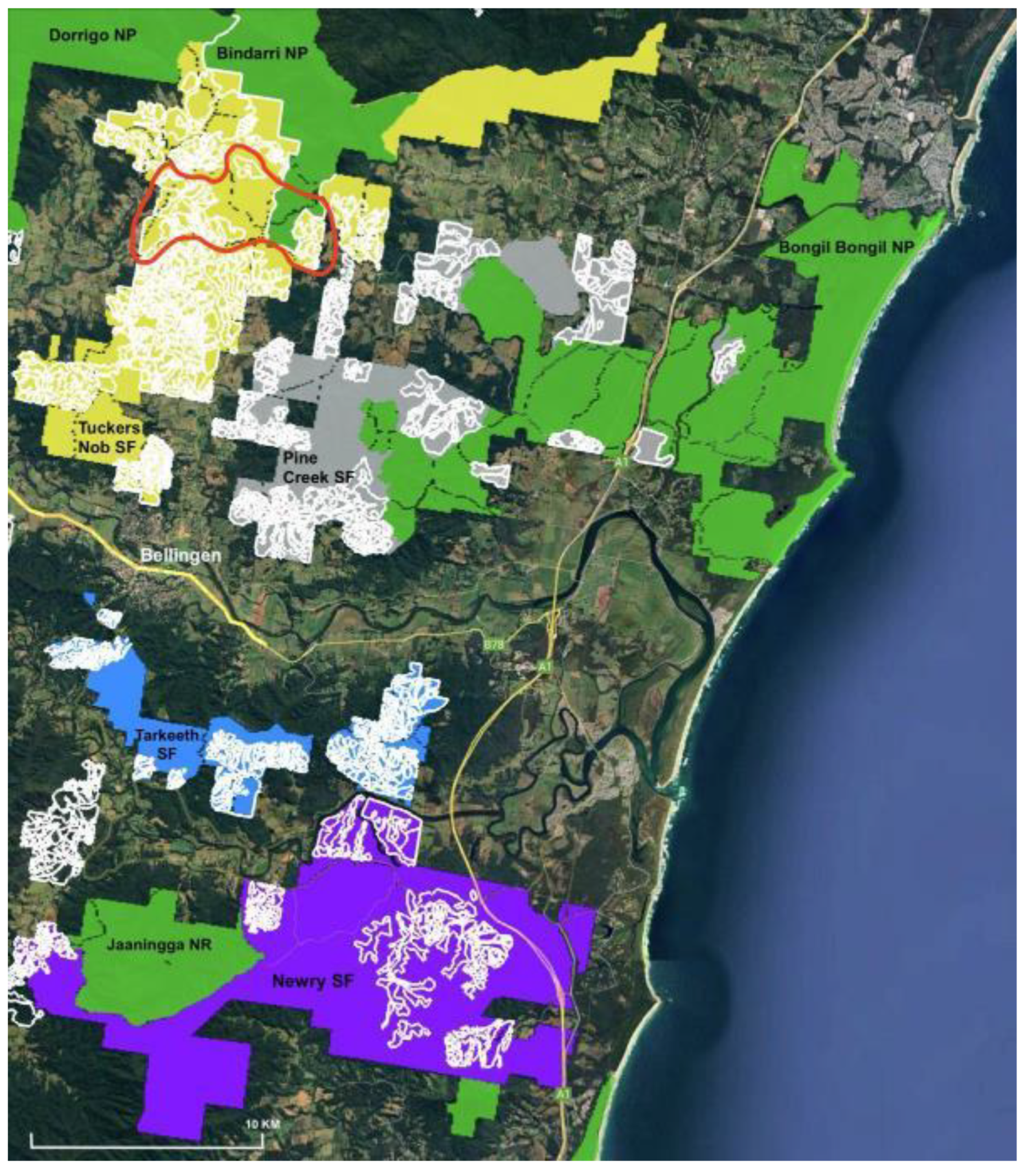
Figure 2.
Proposed Great Koala National Park – mid north coast of NSW. OpenMapTiles, Open Street Map and contributors, Commons, public domain [1]. Light green indicates existing national parks; dark green, state forests; red, koala hubs; yellow, plantations.
Figure 2.
Proposed Great Koala National Park – mid north coast of NSW. OpenMapTiles, Open Street Map and contributors, Commons, public domain [1]. Light green indicates existing national parks; dark green, state forests; red, koala hubs; yellow, plantations.
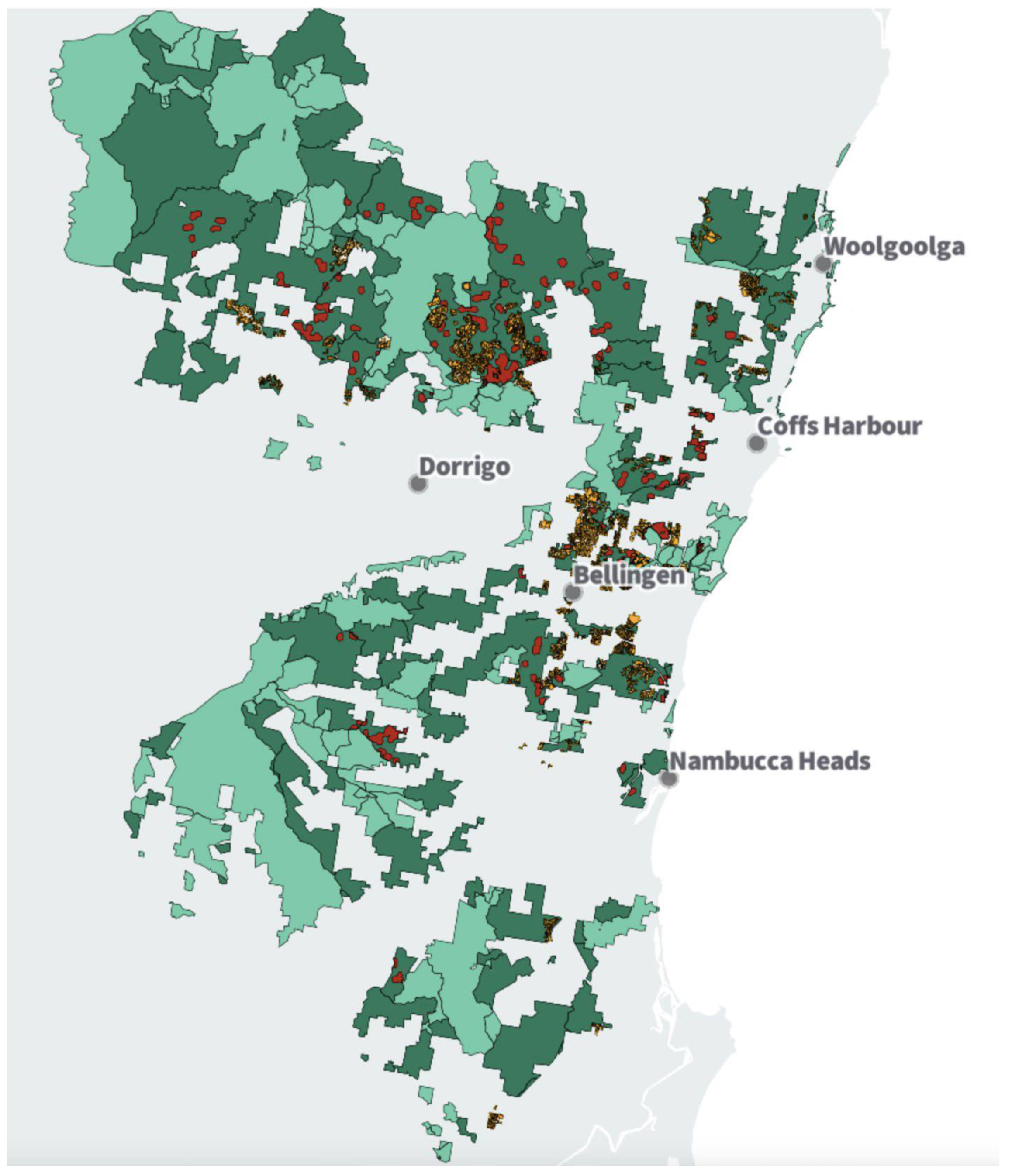
The research is focused on the Tuckers Nob State Forest (SF) (~4,375ha) which is part of the proposed Great Koala National Park to be situated on the mid north coast of the Australian state of NSW. Approximately ~176,000ha of publicly owned state forests, koala hubs and plantations are to be joined with existing National Parks to establish a ~315,000ha nature reserve in the Coffs Coast Region (Figure 2).
2.1. Data Collection
Broadly, the methodologies and general critique used here are derived from [16].
Generally, original trees (an individual specimen in existence before plantation establishment, either as an isolated example, or within a larger cohort of trees) and remnants (a patch of trees, which existed before plantation establishment) were identified using historical aerial photography, orthorectified (geo-referenced) and matched against current NSW Government imagery (SIX Maps). Composite mosaics of photographic sheets and closeups (QGIS) were imported into Google Earth Pro. Data from koala drone surveys, habitat ground-truthing and on-ground scat and koala surveys of 120 ha were obtained from various community stakeholder and volunteer groups who, after appropriate training, conducted surveys between March and December 2024.
In particular, the closeups generated in QGIS (largely using 3.36.3 - Maidenhead) and imported into Google Earth Pro (GEP), used a consistent projection (Figure 3).
Shape files of the areas zoned plantation from FCNSW were imported into Google Earth Pro and compared to the relevant time sequence imagery before and after plantation establishment, to identify surviving original forest. The original photography and SIX Maps are low resolution. Additionally, more recent, imagery in higher resolution from commercial spatial service provider, Nearmap [17] was also used for comparison. Areas of interest (polygons) of original forest were created in .kmz file format and added as a further layer, based on canopy differentiation from the more uniform plantation. These were delineated by following the plantation boundary, or the authorised/operational area boundary, and excluding areas set aside within the draft harvest plan operational map (HPOM); delineation was to the outermost edge of any boundary line, unless marked by FCNSW (Figure 4 and Figure 5).
Georeferenced images suitable for field use were generated in QGIS and imported into a tablet with GNSS (global navigation satellite system) compatibility (iPad) as base layers (maps) using the app Avenza Maps Plus Legacy [18]. The polygons of the remnant areas delineated in GEP were added as a layer onto the base image in .kmz format. Location accuracy of the tablet was enhanced using a bluetooth receiver (Garmin GLO 2 – GPS and GLONASS (navigation system from Russia) compatible). Individual trees and remnant forest were then identified on the ground and photographic records were collected using the camera function on the iPad, also using the enhanced accuracy of the receiver, and imported into the app (Figure 6).
Photographs were captured using two tablets, one to record the image of the tree, the other to locate the tree on the historical photography (Figure 7), the other placed next to the receiver, at the base of the tree, with the relevant image and coordinates displayed, and a tape measure showing circumference at stump height over bark (CSHOB).
Coordinates from both devices were cross-checked. Rainforest trees under 1500mm CSHOB were generally not recorded, unless uncommon (e.g. Ringwood/Aniseed myrtle Syzygium anisatum), or an important exemplar of native vegetation in a given location. This rule of thumb was applied also to Forest oak (Allocasuarina torulosa) and Pink bloodwood (Corymbia intermedia), both non-plantation species. Measurements for Eucalyptus were generally over 2500 mm CSHOB (Figure 8), unless they were part of a larger remnant, or a divergent individual specimen within a plantation. If identified, plantation tree species were avoided (see caveats below). Citizen scientists assisted with data collection, under the supervision of the chief investigator, using this methodology.
These images were subsequently exported into GEP, with image number, species (where identifiable), and CSHOB adding to a central database, or record of trees (Figure 9). These were checked against the historical image layers, and the polygons were amended, if necessary, to create a more accurate delineation of the forest remnant. Individual original trees were also plotted.
2.2. Drone Surveys
Two nights of drone surveillance were conducted, 11-12 and 12-13 December 2024 (10 pm – 5 am), using a drone (DJI Matrice 350) with a thermal camera (H30T sensor).
Selected polygons were surveyed at 30m above canopy (following canopy topography) in straight transects with a 40% side-overlap in accordance with the NSW Dept of Planning and Environment Koala Biodiversity Assessment Method Survey Guide [20]. A laser range finder logged the koala location in three-dimensional space to an accuracy of 0.5-4m.
Four survey locations were identified within the areas zoned plantation in Tuckers Nob:
- Compartment 8 (partially surveyed for original forest and trees), 20 ha;
- Compartments 10 and 18 (partially surveyed for original forest and trees), 130 ha;
- Compartments 11 and 17 (partially surveyed for original forest and trees), 50 ha;
- Compartment 12 (fully surveyed for original forest and trees), 30 ha.
The sites were selected to achieve the maximum coverage of the most unlogged areas of zoned plantation (Figure 11), at the best time-cost efficiency ratio.
2.4. Caveats
NSW government data are generally in Lambert projection. This is spatially very accurate, but does not translate well across platforms, particularly for field-based systems that rely on GPS. Data and imagery were therefore generated or reprojected in GDA 94 [21] (Geocentric Datum of Australia 1994: a reference system for defining location via coordinates).
Locating individual trees under canopy is notoriously difficult. While a GPS receiver can enhance accuracy, it needs to be continually refreshed by returning to open sky and is further impacted by cloudy weather and steep terrain. Consequently, the accuracy of records can vary from between 5 and 15, and at worst, 20 metres. This is ameliorated somewhat by the delineation of polygons where patches of remnant forest exist, and post-logging verification of removals, which occur after the loss of canopy through clearing. This is the main reason for mapping, measuring and photographing trees before logging commences. Trees, with a CSHOB of less than 1500mm (unless significant, such as an uncommon species) and non-original (i.e. in-planted) trees, were not recorded. It is accepted that there may be misidentification of trees species, especially rainforest species. The point to be made here is that no original rainforest should be removed. Some plantation species may be included in records. Generally, such species were avoided, unless they were larger trees than those surrounding them, and therefore potentially of an older, original cohort. A 10% margin of error of target plantation species (i.e. species listed on plantation records as tree species used during establishment, and possibly actual plantation trees) is accepted. However, it should be noted that native trees of the same species (i.e. not planted) are also present.
Some scats were collected prior to taking of tree record. All scats, and/or scat collections were filmed. Where there was a discrepancy between the co-ordinates of the film, and those of the tree record, the tree record was used.
Absolute drone coordinates have been turned into derived point data (clamped to ground) for visual representation in the imagery provided below. A margin of error of approximately 10m is accepted. Unclear sightings were confirmed via thermal signature and night-vision imagery.
The term ‘area zoned plantation’ is used throughout as the concept of plantation in NSW is moot, both in terms of boundaries (plantable, authorised, general, and operational), zonings – Forest Management Zones (FMZ5 management, other management, FMZ6 for softwoods) as well as definitions (which include native forest, silvicultural regrowth, seeded, planted, and unplanted natural regeneration). The term area zoned plantation is used here to generally refer to areas likely to be logged during forestry operations.
Imagery of the year of, or close to, the establishment of plantations in compartment 12 was not available at the time of writing. Remnants were generated from earlier and later images, or via rubber-sheeting (in the case of 1992).
3. Results
3.1. Remnant Forest and Original Trees
Six plantation subunits within the aerial drone surveillance area were comprehensively surveyed (Figure 12).
Compartment 8
Most of the areas zoned plantation were cleared in 2010, except for two units, to the north (established 1992) (Figure 13). The area investigated (ca. 4.3ha) contained some original trees (ca. 11) and four small remnant forest fragments (0.19ha in total) (Figure 13). The significance of this area lies in the fact it is surrounded on three sides by Bindarri NP, and contains original forest (ca. 1.5ha, some recently re-classified as FM4 and available for future native forest logging, and FMZ5 currently not available for logging). The area is zoned delayed thinning (in the area surveyed) and thinning stage 1.
Compartment 10
The area to the north of the compartment was cleared in 2015, but the sub-unit of 10ha investigated (Figure 14) is in excellent ecological condition, having been established in 1964, and has had only 1 partial thinning. Almost two hundred original, non-planted trees were identified, including old growth trees, and rainforest species. Well over half (ca. 6ha) is original forest. Rainforest species, Pink bloodwoods and Forest oaks are well-represented. Several large trees are within the area, including one Coastal blackbutt (E. pilularis) over 7m in circumference, around which a thriving mixed-species remnant survives. The area is zoned clearfall stage 1, thinning stage 2 and delayed thinning.
Compartment 12
The areas zoned Plantation in this compartment are a little over 14.5ha and were established in 1989 (Figure 15). There has been only one, partial thinning. Over 2ha of original forest exists inside the area zoned for wood production, and there are more than 180 trees designated for removal. The single largest remnant of 0.67ha is rainforest, with Jackwood, Pencil cedar (Polyscias murrayi) and a singular small Giant stinging tree (Dendrocnide excelsa). There are many large Forest oaks. Only compartment 12 has been comprehensively surveyed so far. The road was cleared in preparation for logging. The area is zoned Delayed thinning.
Compartment 18
Two small subunits were investigated, comprising 1.44 and 1.37ha respectively (Figure 16). Both areas were part of a larger unit, recently re-configured, which dates to 1980. These have not been thinned.
The western area is particularly diverse, with several Jackwood (C. glaucescens) over 2m in circumference, as well as Brushbox (Lophostemon confertus) and Pink bloodwood. This area is not classifiable as plantation, even if plantation trees are in-planted; it is rainforest. Both areas are zoned delayed thinning.
3.2. Koala Scats and Sightings
Prior to recommencement of logging operations in Tuckers Nob SF, there were approximately 75 records for koalas in the NSW Government SEED database for this area. The sightings of koalas leaving compartments 26-27 during logging last year, and the annexation of adjacent forest in compartments 8-18, where fresh scats were found shaped a view by local residents, supported by their own experience, that the areas zoned plantation contained more koalas than the records suggested. Further ground investigations have now resulted in six new scat records, and 19 sightings – in only 120ha (Figure 17). Two additional sightings were in nearby areas zoned native forest.
Compartment 8
There are five SEED records for Compartment 8 (Figure 18), three in the survey area (of which one was in the area zoned plantation), all collected before clearfall operations in 2008. The area selected was comprehensively surveyed. No koalas were located during aerial drone surveillance. Two glider species, Squirrel glider (Petaurus norfolcensis) listed as vulnerable in NSW [22], and Feathertail glider (Acrobates pygmaeus) were sighted.
A flyover of the adjacent forest in Bindarri NP was also conducted for serendipitous sightings; there were none. The loss of suitable habitat may have impacted the population as a whole, including in the survey area (established 1992, not yet logged).
Compartment 10
There is one SEED record for Compartment 10 (Figure 19). The selected area has not yet been comprehensively surveyed. Two scat records were found prior to the aerial drone survey work, both in areas annexed by FCNSW into the new plantation logging boundaries. Drone surveillance identified 10 koalas. With the exception of K11, all koalas, and scats, were located within the areas zoned for logging. This takes the number of koala records in compartment 10 (97.7 ha) from 1 to 13, i.e. from a ratio of 1 koala record per 98 ha to 1 per 7.5 ha.
It is to be noted that three of the four records collected for the comprehensively evaluated sub-unit in compartment 10 are in remnant forest; the fourth is close by (Figure 20).
Compartment 12
There are no SEED records for Compartment 12. The area selected was comprehensively surveyed (Figure 21). A small area to the south-east outside the authorised plantation was excluded.
Drone surveillance identified nine koalas. Two were serendipitous sightings, one in the area zoned native forest within the compartment (K), and one in an adjacent compartment (11; K15), not yet fully surveyed. Two sightings were in the area zoned for logging (K16, K17), and four within the authorised plantation boundary (K14, K18, K19, K20).
One scat record was found prior to the aerial drone survey work (KS3), three subsequently (KS3, KS4, KS5, KS6) all within the proposed logging area.
This increases the number of koala records in compartment 12 (65.8 ha) from 0 to 11, i.e. a ratio of 1 koala record per 6ha; much higher if the area zoned plantation is taken as the baseline ratio (ca. 21 ha; i.e. one koala record per 2 ha).
Of note is the close, but not complete, association of koala records with remnant forest within the area zoned plantation. The scats were located under Tallowwood (KS4), Jackwood (KS4), and Forest oak (KS5, KS6), once again highlighting the importance of these species.
Compartment 18
There are no SEED records for Compartment 18 (79.9 ha; ca. 39 ha included in the survey area). The selected area had not yet been comprehensively surveyed at time of writing. No scats have been found to date (Figure 22).
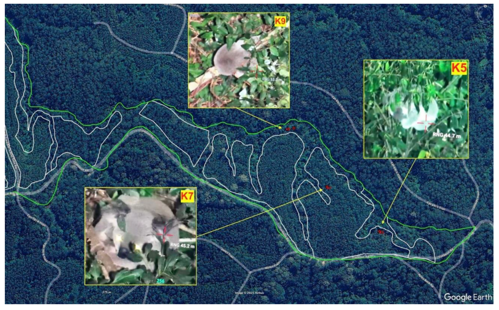
Drone surveillance identified three koalas, one in the streamside buffer (K9), two on the edge of the previously retained vegetation (K5, K7) within the newly established plantation (2015), which is to be thinned.
This increases the number of koala records in compartment 18 (79.9 ha) from 0 to 3, i.e. a ratio of 1 koala per 27 ha.
4. Discussion
Our research has revealed hundreds of original trees, and numerous remnant forest areas located within compartments 8-18 in Tuckers Nob SF. A draft harvest plan operational map (HPOM) has been released. Only those patches of original forest and individual trees within the logging footprint have been included in the calculations. It is accepted that some original forest and individual trees have been set aside from logging, however, it is extremely concerning that some areas of FMZ5 featured in previous boundary data as being out of productive management (e.g. watercourses) have now been re-designated delayed thinning. There are many such areas rezoned in this manner on the HPOM. It is also a matter of concern that areas of original forest and individual trees ‘swapped out’ of production have also been ‘swapped in’ by replacement trees and areas because of boundary adjustments. Several of these locations were identified as koala habitat during investigations.
The areas zoned plantation in Tuckers Nob contain koala numbers which are at least on a par with, and in some instances (e.g. compartment 12), exceed the native forest currently under assessment for inclusion in the proposed park.
There is a correlation between koalas, original trees and remnant forest. However, it should also be noted that the presence of koalas on the edge of plantations indicates a preference for a diverse mosaic of forest ages, and, given the evidence of the number of scats, an interest in rainforest species. The regular sighting of koalas near the intersection between remnant and plantation or re-growth has been observed also in Victorian Blue gum plantations [23]. The sighting of a koala eating Forest oak is rare and highlights the importance of this tree (which is often classed as ‘ingrowth’ by FCNSW and cleared), for local koala populations. The disappearance of koalas in the area surveyed in compartment 8, is possibly associated with recent clearing, and the low numbers in compartment 18, by comparison to compartments 10 and 12, should be a source of concern; indeed, [24] argue that in such sensitive areas, cessation of timber harvesting is a priority. Instead, such areas should be excluded from forestry and instead be considered as essential koala habitat.
Further survey work needs to be completed, and if possible expanded, to confirm these initial findings.
5. Conclusions
We investigated the assertion that hardwood plantations may increase the value of koala habitat in metapopulations of the GKNP and found that the value of plantations as koala habitat rests on the extent of the koala habitat within it and the degree of disturbance it has experienced. Our results indicate that koala populations within a plantation are likely to function at a landscape level by using a mosaic of vegetation plots of different ages. As the example of our investigation into the koala habitat in the Tuckers Nob shows, it is of concern that many areas zoned hardwood plantations in NSW are likely plantations in name only, and even if planted, contain very high numbers of original trees, and multiple patches of surviving remnant forest which existed before establishment of the plantations. The older the plantations, the more diverse the species (both planted and surviving) and the higher the number of koalas; the younger, the less diverse and more disturbed, and the lower their numbers.
It is rational that an animal that spends much of its time in trees, obtains most of its water from leaves, and prefers forest areas on fertile soils, would find the older plantations of Tuckers Nob, established on previously cleared moist lowland coastal forests and rainforests, attractive. It is essential to take this into consideration during any assessment process and exclude such areas from harvesting while assessments are not completed. In the absence of properly funded and executed government surveys, support from citizen scientists and community groups in such assessments is of vital importance.
We urge stakeholders to prioritise defining the term sustainable plantations otherwise we risk that the extinction of koalas is exacerbated. We need to rethink how plantations are managed and where these are located in relation to existing koala habitat.
6. Recommendations
We encourage undertaking further survey work across the plantations within the proposed GKNP as a matter of urgency to determine the extent to which our findings are borne out in other areas zoned plantation and for the inclusion of all areas with high koala habitat value into the proposed park. A moratorium on logging pending the outcome of additional surveys and a review of current management of these areas which include the annexation, clearing and conversion of koala habitat in the plantation estate by the Forestry Corporation of NSW.
Involvement of citizen scientists in koala and koala habitat monitoring is to be encouraged, especially in the absence of properly funded and executed government surveys.
A meaningful definition of the term sustainable plantation management developed in consultation with all stakeholders is needed, otherwise there is a risk that the extinction of koalas will be exacerbated.
Acknowledgment to Country
The authors acknowledge the Gumbaynggirr People as the Traditional Custodians of the land where this research focused on. They value the contribution of Elders past, present and emerging and recognise and respect the cultural heritage and beliefs of Aboriginal people and are committed to honouring Gumbaynggirr people’s unique cultural and spiritual relationship to the land, rivers, and sea.
Author Contributions
Conceptualization, T.C, S.C.; methodology, T.C..; software, T.C..; validation, T.C.; formal analysis, T.C.; investigation, T.C and citizen scientists.; resources, T.C.; data curation, T.C.; writing—original draft preparation, R.S., T.C., F.S., M.D., D.M., I.C and A.M; writing—review and editing, R.S., T.C., F.S., M.D., D.M., I.C., F.C. and A.M.; visualization, T.C.; supervision, T.C.; project administration, T.C.; funding acquisition, T.C. All authors have read and agreed to the published version of the manuscript.
Funding
This research received an in-kind contribution from the Bob Brown Foundation to offset the cost of orthorectification of historical aerial photography. Subsequent drone survey work was undertaken by Ripper Corp, with financial support provided by WWF Australia. This research was funded via an internal small grant from Griffith University’s Arts, Education and Law Group ($8,983) with an additional cash contribution of $2,000 each from the Law Futures Centre and the Institute for Ethics, Governance and Law, accounted for via the project Ensuring the sustainability of plantation management – a citizen science approach (protocol 2022/466).
Institutional Review Board Statement
Ethical review and approval was obtained for the project Ensuring the sustainability of plantation management – a citizen science approach under protocol 2022/466. All drone survey work was undertaken by qualified and authorised staff, in accordance with following recommended NSW Government guidelines [25].
Data Availability Statement
The study’s data can be obtained upon request from Dr Tim Cadman. SIX Maps may be viewed here; Unrectified historical imagery may be viewed here. Forest conversion, citizen science training, and koala records may be viewed here.
Conflicts of Interest
The authors declare no conflicts of interest. The funders had no role in the design of the study; in the collection, analyses, or interpretation of data; in the writing of the manuscript; or in the decision to publish the results.
References
- Cadman, T. and Clode, D. A Home among the Gum Trees: Will the Great Koala National Park Actually Save Koalas? The Conversation. 2023. Retrieved from https://theconversation.com/a-home-among-the-gum-trees-will-the-great-koala-national-park-actually-save-koalas-217276.
- Leys, A. J., & Vanclay, J. K. Land-use change conflict arising from plantation forestry expansion: Views across Australian fencelines. International Forestry Review, 2010, 12(3), 256-269.
- Department of Agriculture, Water and the Environment. Conservation Advice for Phascolarctos cinereus (Koala) Combined Populations of Queensland, New South Wales and the Australian Capital Territory, 2022. Canberra, Australia.
- Cahir, F., Schlagloth, R., & Clark, I. D. The historic importance of the koala in Aboriginal society in New South Wales, Australia: An exploration of the archival record. ab-Original: Journal of Indigenous Studies and First Nations and First Peoples' Cultures, 2020, 3(2), 172-191.
- Schlagloth, R., Golding, B., Kentish, B., McGinnis, G., Clark, I.D., Cadman, T., Cahir, F. & Santamaria, F. Koalas–Agents for Change: A case study from regional Victoria. Journal of Sustainability Education. 2022. https://www.susted.com/wordpress/?s=koala.
- Schlagloth, R., F. Santamaria, B. Golding, and H. Thomson. Why is It Important to Use Flagship Species in Community Education? The Koala as a Case Study. Animal Studies Journal, 2018, 7 (1): 127–148.
- Sequeira, A. M. M., Roetman, P. E. J., Daniels, C. B., Baker, A. K., & Bradshaw, C. J. A. Distribution models for koalas in South Australia using citizen science-collected data. Ecology and Evolution, 2014, 4(11), 2103-2114.
- Brown, G., McAlpine, C., Rhodes, J., Lunney, D., Goldingay, R., Fielding, K., Hetherington, S., Hopkins, M., Manning, C., Wood, M., Brace, A., & Vass, L. Assessing the validity of crowdsourced wildlife observations for conservation using public participatory mapping methods. Biological Conservation, 2018, 227, 141-151.
- Hollow, B. , Roetman, P. E., Walter, M., & Daniels, C. B. Citizen science for policy development: The case of koala management in South Australia. Environmental Science & Policy, 2015, 47, 126–136. [Google Scholar]
- Flower, E., Jones, D., & Bernede, L. Can citizen science assist in determining koala (Phascolarctos cinereus) presence in a declining population? Animals, 2016, 6(7), 42.
- Stenhouse, A. , Roetman, P., Lewis, M., & Koh, L. P. Koala Counter: Recording citizen scientists’ search paths to improve data quality. Global Ecology and Conservation, 2020, 24, e01376. [Google Scholar]
- Dissanayake, R. B., Stevenson, M., Allavena, R., & Henning, J. The value of long-term citizen science data for monitoring koala populations. Scientific Reports, 2019, 9(1), 10037.
- Danaher, M., Schlagloth, R., Hewson, M., & Geddes, C. One person and a camera: a relatively non-intrusive approach to Koala citizen science. Australian Zoologist, 2023, 43(1), 52-66.
- Cleary, G. Welcome to the anatomy of the great koala count. Nature New South Wales, 2013, 57(4), 5-7.
- Predavec, M., Lunney, D., Shannon, I., Lemon, J., Sonawane, I., & Crowther, M. Using repeat citizen science surveys of koalas to assess their population trend in the north-west of New South Wales: scale matters. Australian Mammalogy, 2017, 40(1), 47-57.
- Cadman, T., Schlagloth, R., Santamaria, F., Morgan, E., Clode, D., & Cadman, S. Koalas, Climate, Conservation, and the Community: A Case Study of the Proposed Great Koala National Park, New South Wales, Australia. The International Journal of Social Quality, 2023, 13(1), 25-55.
- Nearmap. Turn location data into insightful answers. 2025, www.nearmap.com/au.
- Avenza Systems Inc. System software company, 2025. www.avenza.com.
- Canines for Wildlife. Conservation detection dogs. 2025, https://caninesforwildlife.com/.
- State of NSW and Department of Planning and Environment. Koala (Phascolarctos cinereus) Biodiversity Assessment Method Survey Guide. Environment and Heritage Group Department of Planning and Environment, Parramatta NSW. 2022, https://www2.environment.nsw.gov.au/publications/koala-phascolarctos-cinereus-biodiversity-assessment-method-survey-guide.
- Geocentric Datum of Australia 1994. The Australian Geospatial Reference System. Intergovernmental Committee on Survey and Mapping. Accessed 10 August 2024. https://www.icsm.gov.au/datum/geocentric-datum-australia-1994-gda94.
- NSW Government (Office of Environment and Heritage). Squirrel Glider Profile. 2024, https://threatenedspecies.bionet.nsw.gov.au/profile?id=10604.
- Schlagloth, R., Santamaria, F., Mitchell, D., & Rhodes, J. Use of blue gum plantations by koalas - a report to stakeholders in the plantation industry. 2008, Australian Koala Foundation, Brisbane, Australia.
- Smith, A. P., & Pile, J. Koala density, habitat, conservation, and response to logging in eucalyptus forest; a review and critical evaluation of call monitoring, 2024. Australian Zoologist, 44(1), 44-76.
- Government of NSW. Koala (Phascolarctos cinereus) Biodiversity Assessment Method Survey Guide. 2022. Available from: https://www2.environment.nsw.gov.au/sites/default/files/koala-phascolarctos-cinereus-biodiversity-assessment-method-survey-guide-220249.pdf.
Figure 3.
Closeup of Tuckers Nob SF imported into Google Earth Pro (NSW Government imagery).
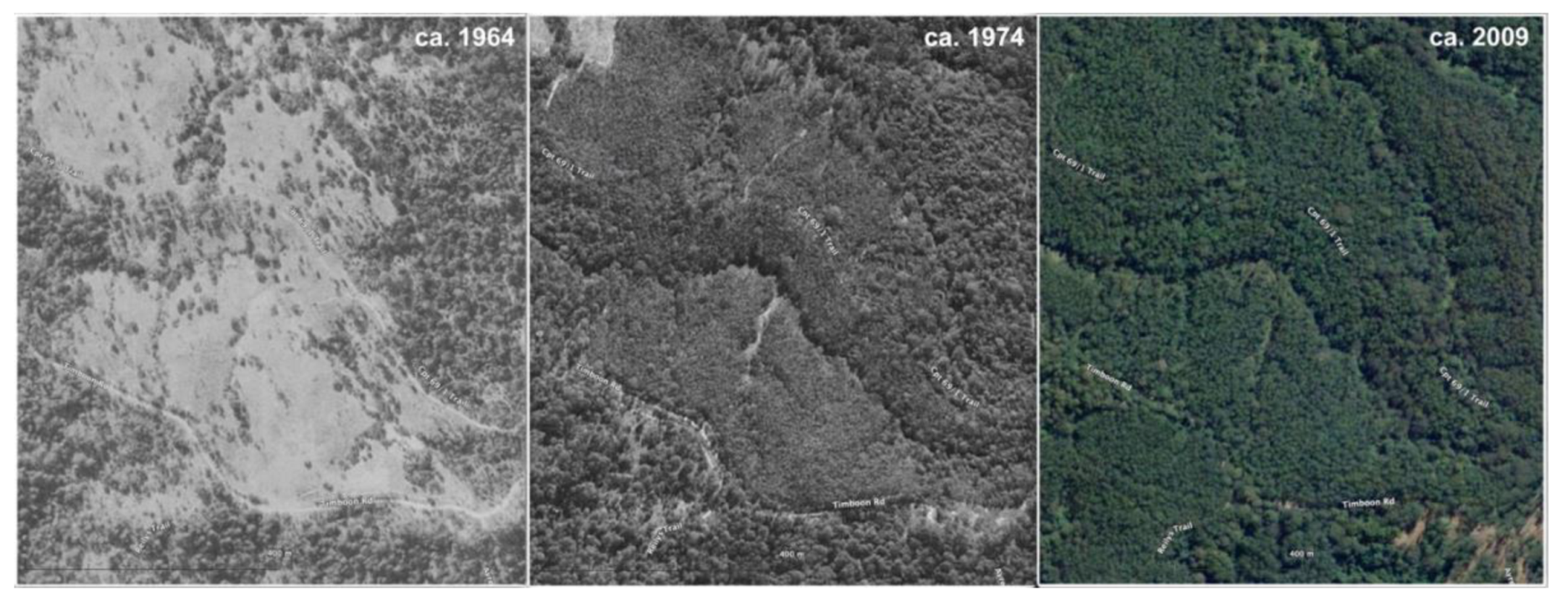
Figure 4.
Remnant forest pre and post establishment inside an area of zoned plantation. Notes: 1) the area was established as a plantation in 1964; 2) the image to the right is approximately ten years later – larger canopy trees, existing prior to and after establishment are visible; 3) Remnant forest in red polygons; 4) area zoned plantation is the green polygon; 4) all imagery NSW Government data.
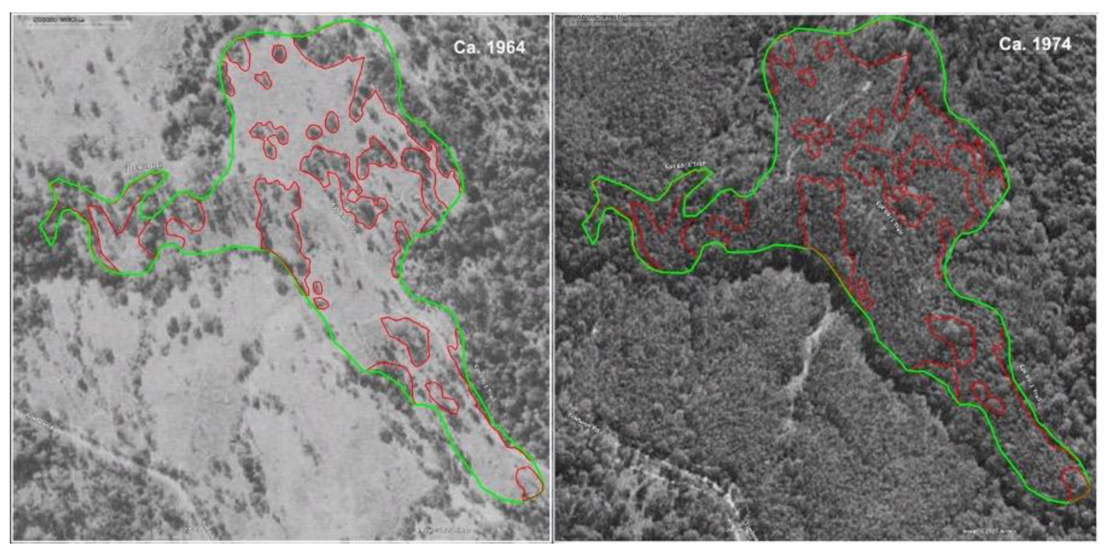
Figure 5.
Figure 5. SIX Maps; draft HPOM. Notes: 1) SIX Maps imagery is generally used by NSW agencies, and is of lower resolution than commercial imagery; 2) The image to the right is a closeup of the HPOM, showing various management zones; FCNSW has included some remnants on this map, delineated as Higher remnant tree potential– these are within the clearfall zone; 3) remnants delineated as red polygons (stippled infill marked on HPOM); 4) current boundary of sub-unit of area zoned plantation delineated as a green polygon in image on the left; 5) all imagery NSW Government data.
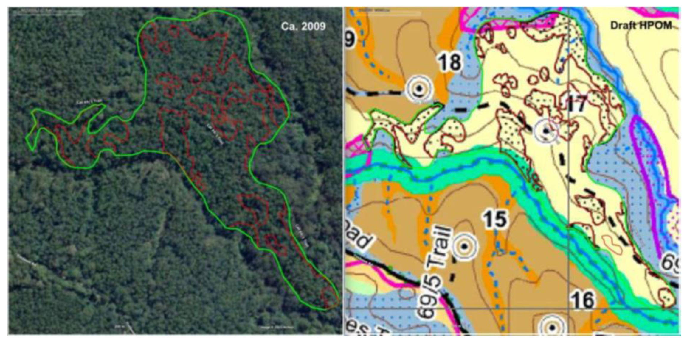
Figure 6.
Screenshots of the record of trees captured in Avenza and historical imagery. Notes: 1) The image to the left is from SIX Maps used to locate surviving trees (white boundaries are the areas zoned plantation, 2) The red dots are original trees in the current plantation sub-unit, 3) yellow dots are trees removed from this sub-unit as a consequence of boundary changes (but not necessarily set aside from production), 4) blue dots are trees annexed into the reconfigured plantation sub unit; 5) the image to the right is from 1964, used to inform field verification, 6) the blue boundary is from 2021, 7) the orange boundary is the current configuration – this demonstrates the continually shifting delineation of what is zoned plantation 8) all imagery NSW Government data.

Figure 7.
Record of tree on Avenza as placemark, and with metadata.
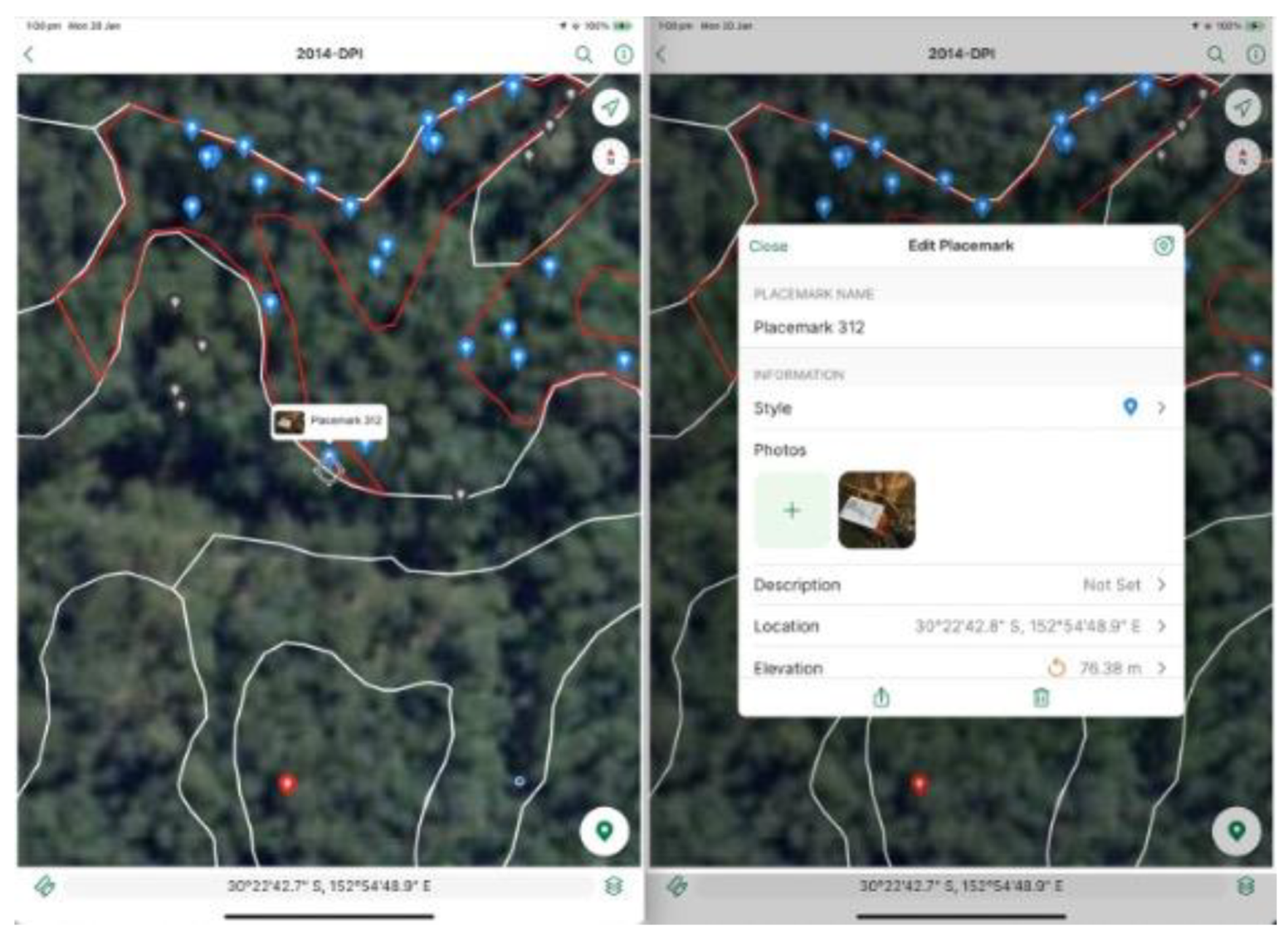
Figure 8.
Photographic record of original tree (Pink bloodwood, 2720 mm CSHOB).
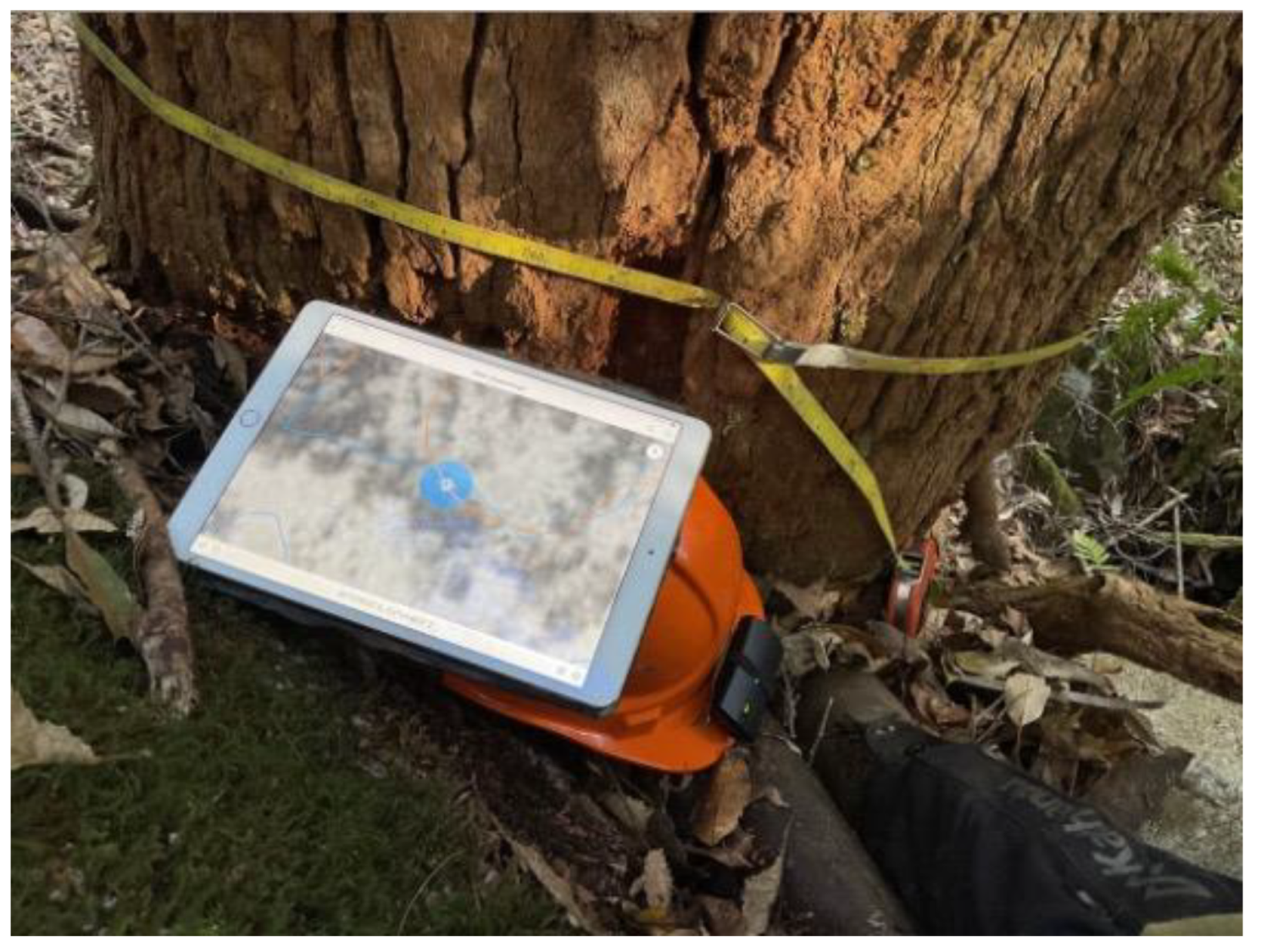
Figure 9.
Individual tree (C. intermedia, 2720mm CSHOB) entered on central database.
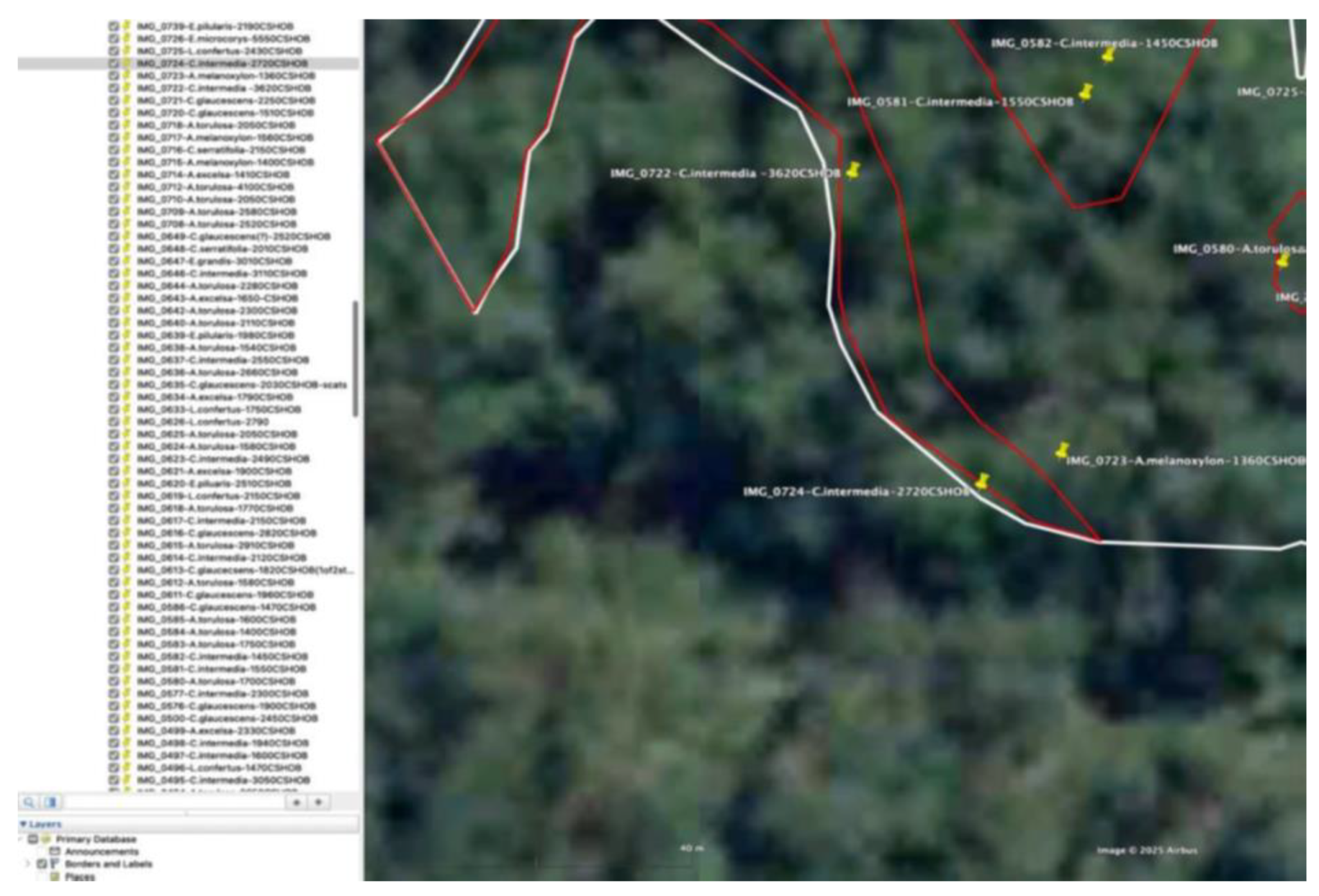
Figure 10.
Record of tree (Cryptocaria glaucescens 2030mm CSHOB) with scats in situ.
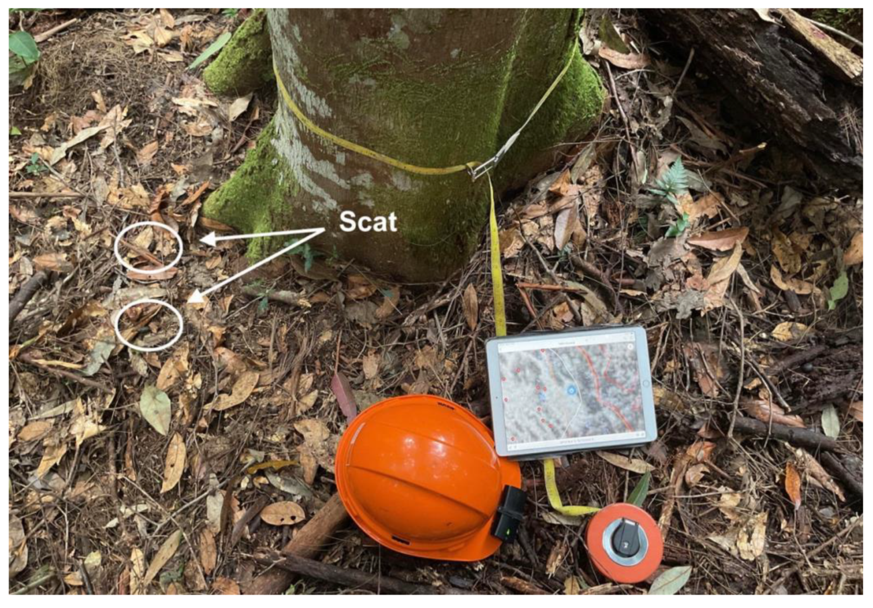
Figure 11.
Study area surveyed during the research. Notes: 1) Compartments (green polygon); sites (red polygon); surveyed (yellow polygon).
Figure 11.
Study area surveyed during the research. Notes: 1) Compartments (green polygon); sites (red polygon); surveyed (yellow polygon).
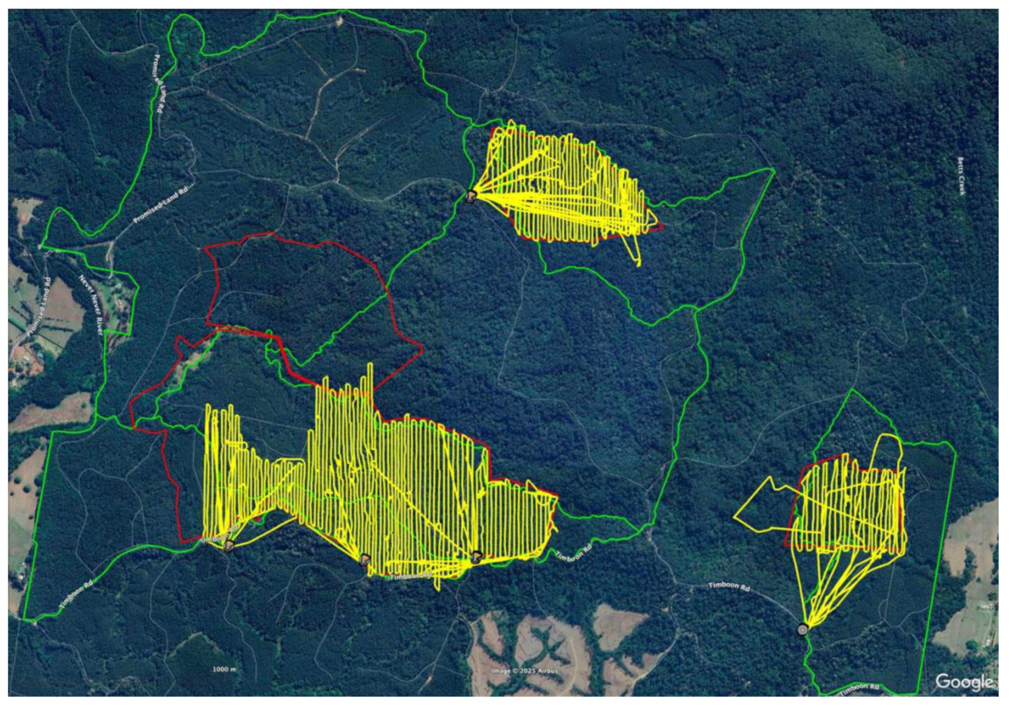
Figure 12.
All areas zoned Plantation currently scheduled for logging. Notes: 1) Red polygons (surveyed areas); 2) white polygons (areas zoned plantation); green polygons (compartment boundaries); compartment numbers in yellow.
Figure 12.
All areas zoned Plantation currently scheduled for logging. Notes: 1) Red polygons (surveyed areas); 2) white polygons (areas zoned plantation); green polygons (compartment boundaries); compartment numbers in yellow.
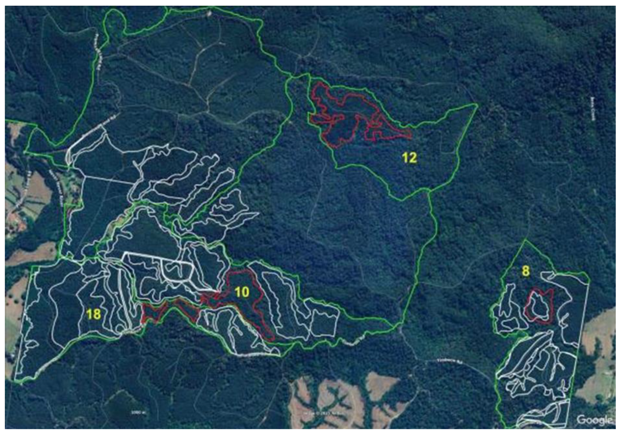
Figure 13.
Authorised area within compartment 8. Notes: 1) White polygons (areas zoned plantation); 2) red polygons (remnant forest); 3) yellow pin – tree record, indicating locations of original trees of which the details are contained in the text attached to each pin (image number, tree species and CSHOB). 5) The area is zoned delayed thinning. 6) authorised area zoned plantation used as boundary, but only those trees within the two sub-units inside the logging area included.
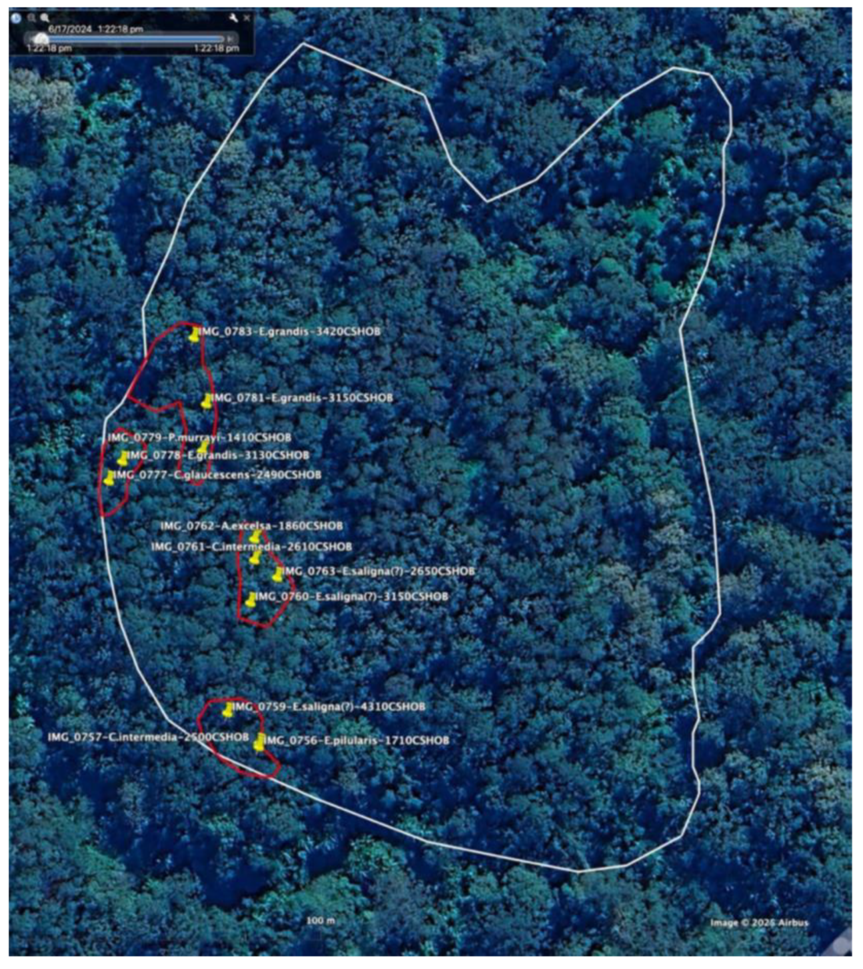
Figure 14.
Subunit within compartment 10, with tree records. Note: Zoned clearfall stage 1.
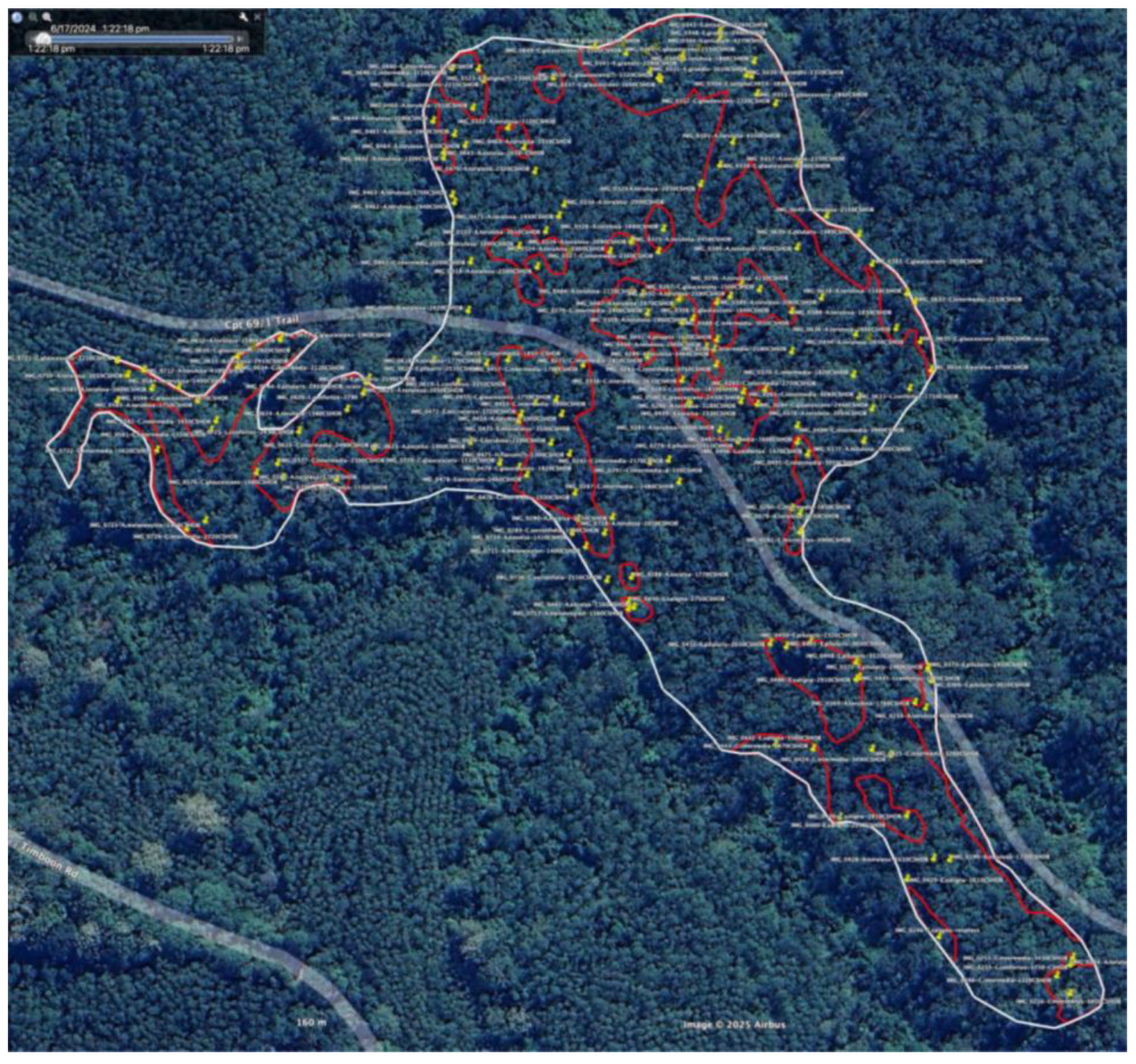
Figure 15.
Area zoned plantation investigated within compartment 12, with remnants and tree records. Note: Zoned delayed thinning.
Figure 15.
Area zoned plantation investigated within compartment 12, with remnants and tree records. Note: Zoned delayed thinning.
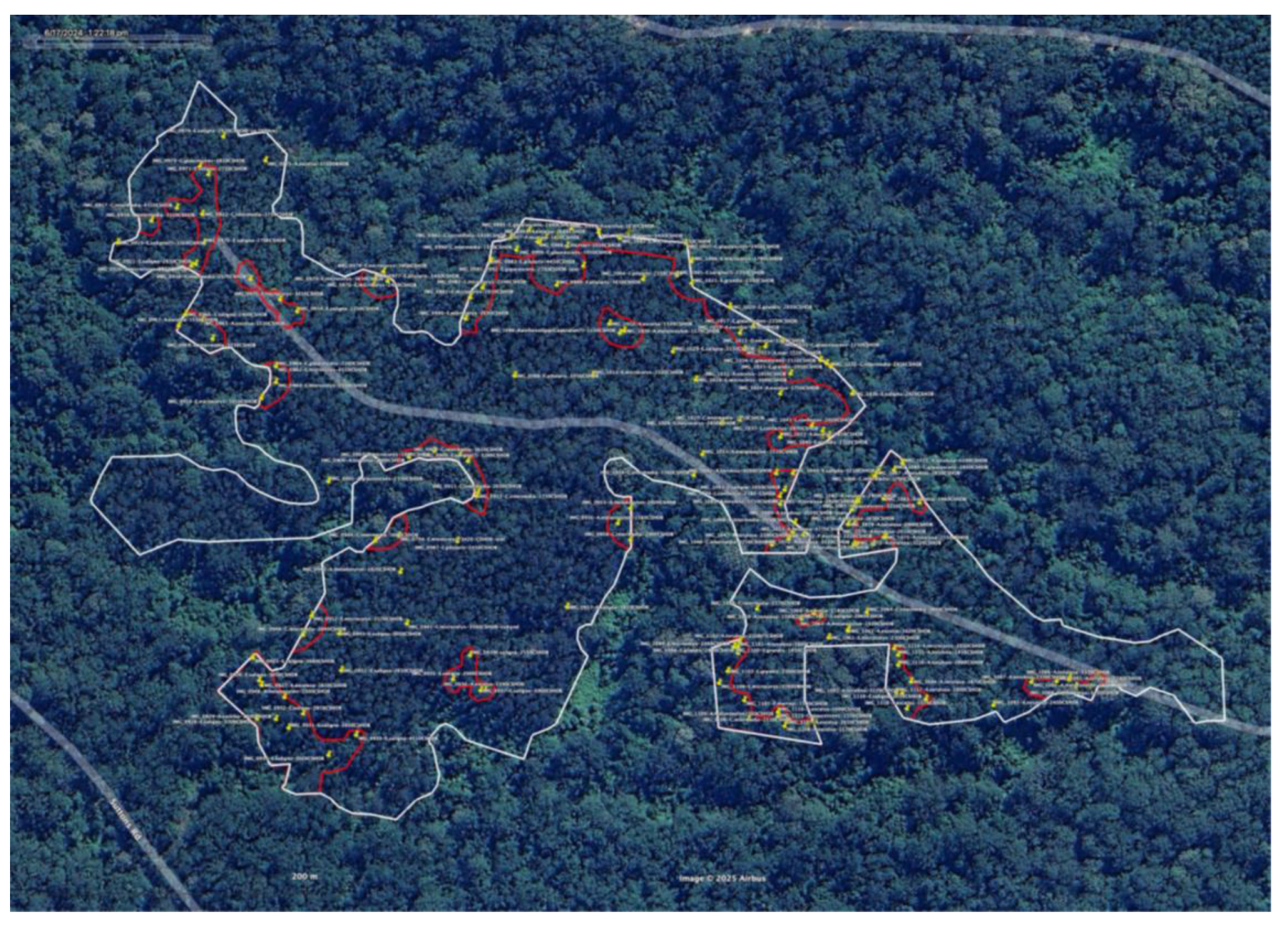
Figure 16.
Two areas zoned Plantation investigated within compartment 18, with remnants and tree records. Note: Zoned delayed thinning.
Figure 16.
Two areas zoned Plantation investigated within compartment 18, with remnants and tree records. Note: Zoned delayed thinning.
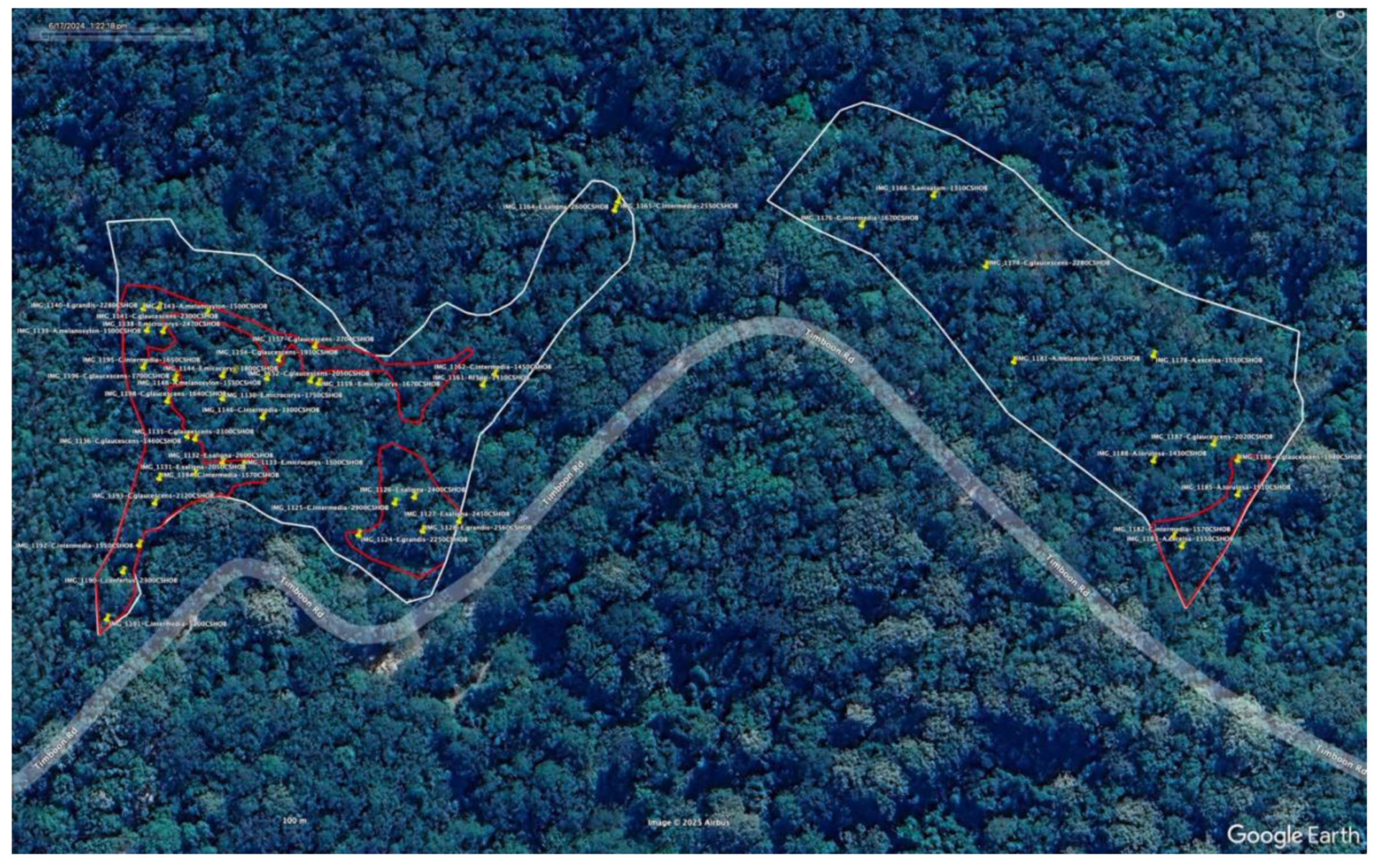
Figure 17.
New koala records compartments 8-18 Tuckers Nob. Notes: 1) white polygons – areas zoned plantation; 2) red polygons – survey area; 3) yellow filled polygons – surveyed to date; 4) red dot – aerial sighting; 5) red pin – scat record.
Figure 17.
New koala records compartments 8-18 Tuckers Nob. Notes: 1) white polygons – areas zoned plantation; 2) red polygons – survey area; 3) yellow filled polygons – surveyed to date; 4) red dot – aerial sighting; 5) red pin – scat record.
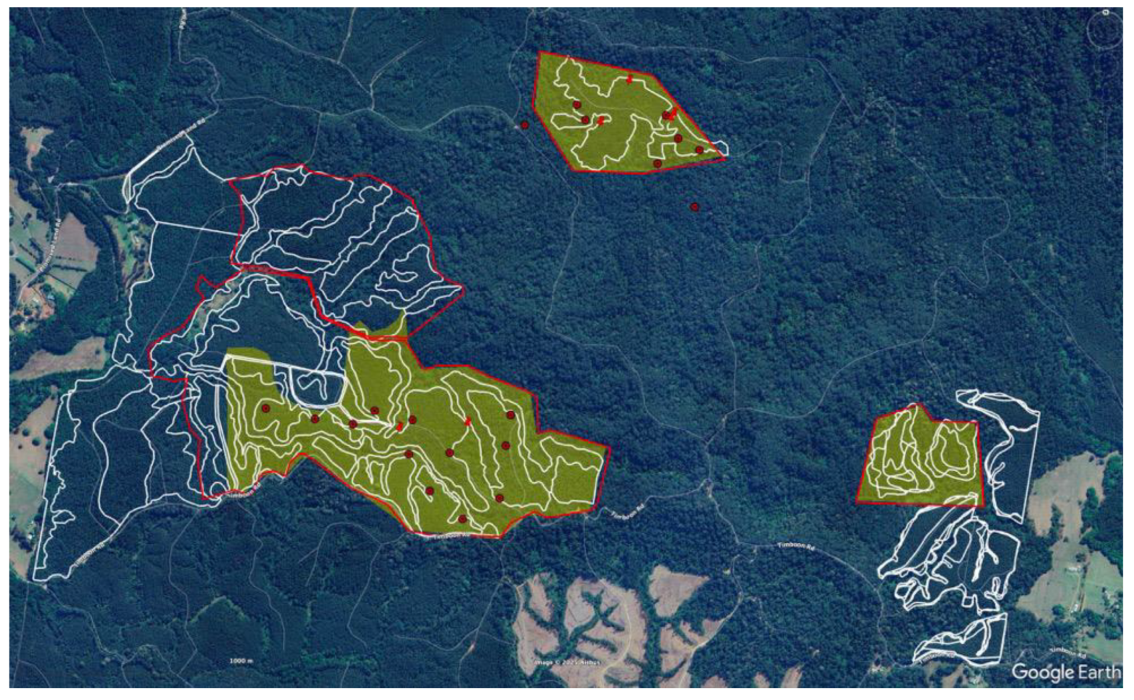
Figure 18.
Koala records for Compartment 8. Notes: 1) koala icons – SEED records; 2) green polygon – compartment boundary; 3) white polygons – areas zoned plantation.
Figure 18.
Koala records for Compartment 8. Notes: 1) koala icons – SEED records; 2) green polygon – compartment boundary; 3) white polygons – areas zoned plantation.
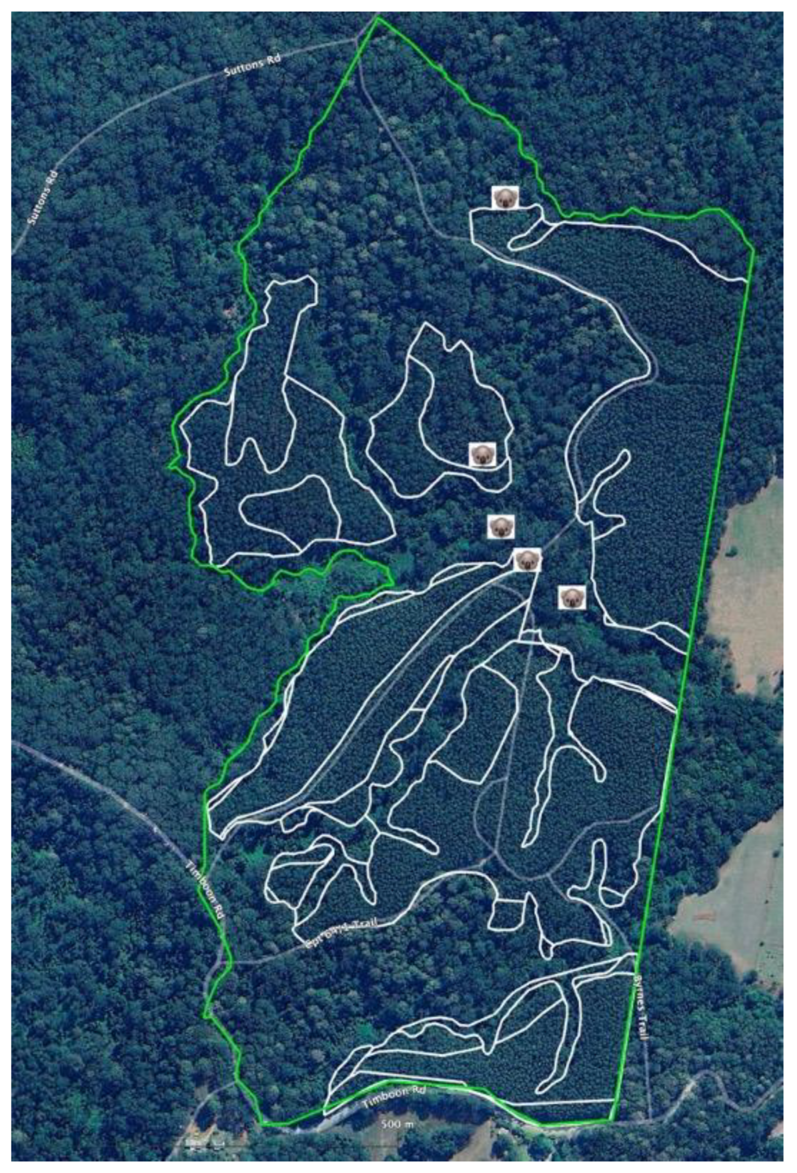
Figure 19.
Koala records for compartment 10, Tuckers Nob SF. Notes: 1) red dot with K(n) – drone sighting; 2) red pin with KS(n) – koala scat; 3) small koala icon – SEED record; 4) magenta polygons – 2021 boundaries; 5) white polygons – current; (expanded) boundaries; 6) green polygon – compartment boundary.
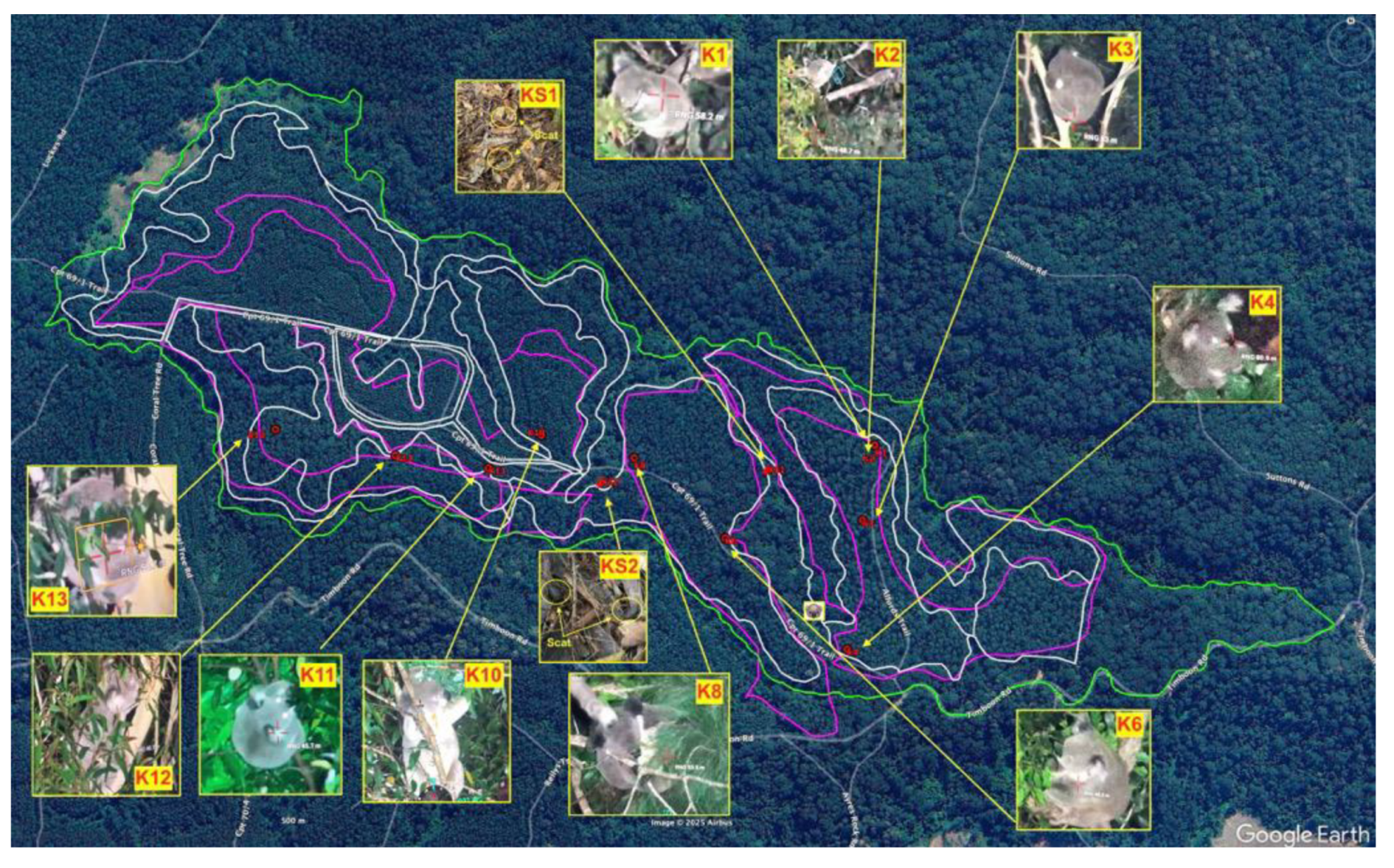
Figure 20.
Koala sightings, scats and remnants in compartment 10. Notes: 1) yellow pins – koala sightings; 2) green pins – koala scats; 3) white polygon – area zoned Plantation; 4) red polygons – remnant forest.
Figure 20.
Koala sightings, scats and remnants in compartment 10. Notes: 1) yellow pins – koala sightings; 2) green pins – koala scats; 3) white polygon – area zoned Plantation; 4) red polygons – remnant forest.
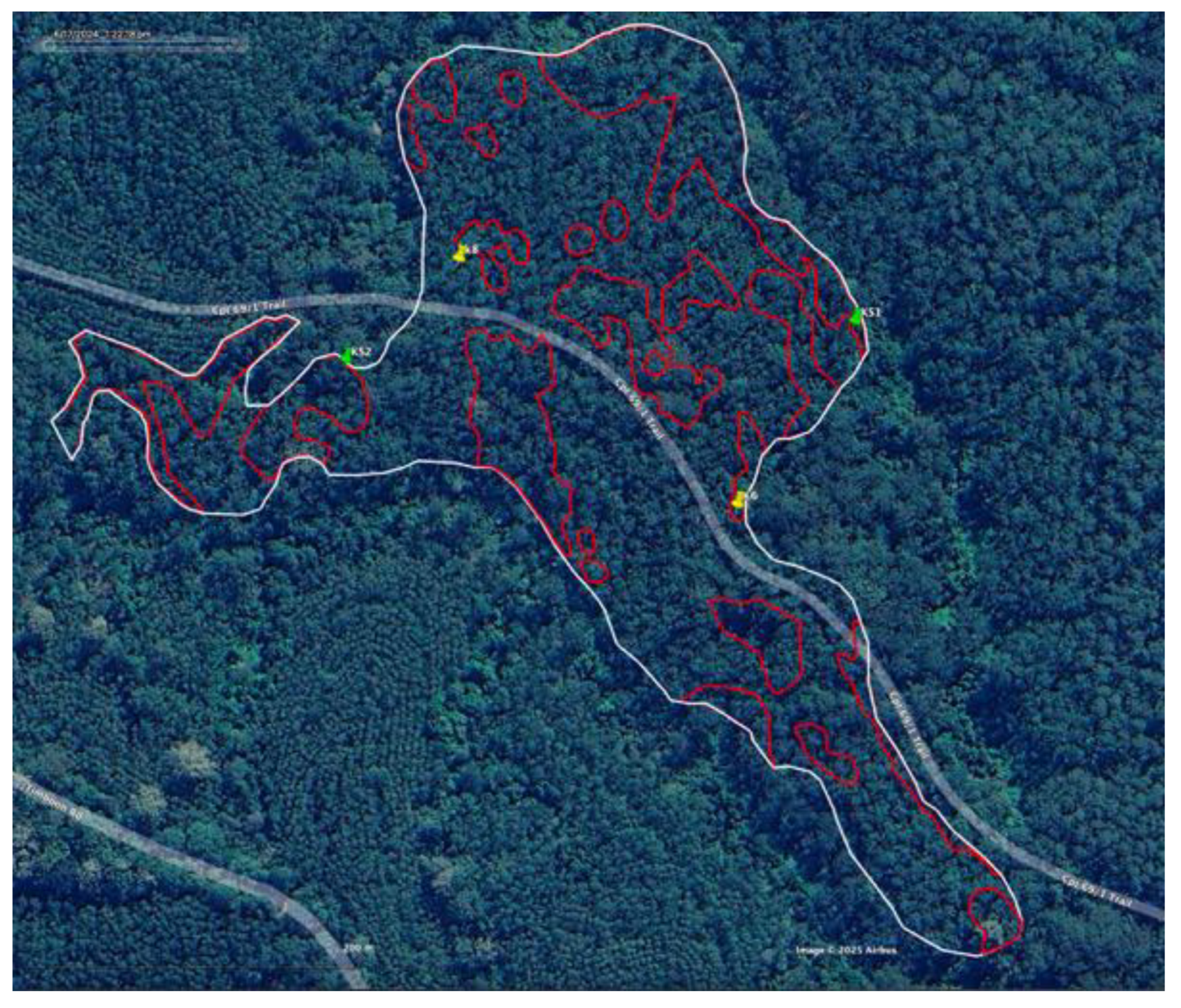
Figure 21.
Koala records for compartment 12. Notes: 1) red dot – drone sighting; 2) red pin – scat; 3) white polygon – area zoned Plantation; 4) green – compartment.
Figure 21.
Koala records for compartment 12. Notes: 1) red dot – drone sighting; 2) red pin – scat; 3) white polygon – area zoned Plantation; 4) green – compartment.
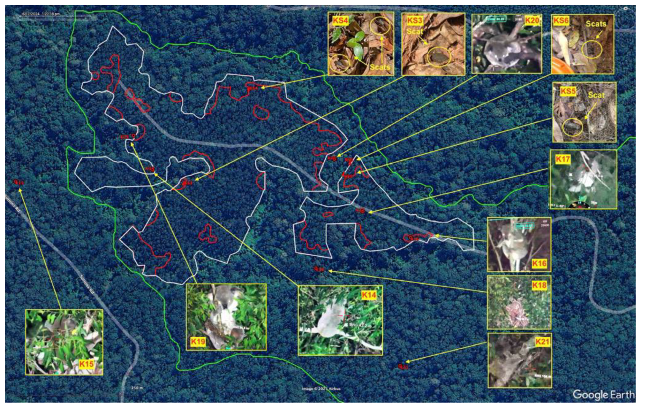
Figure 22.
Koala records for compartment 18. Notes: 1) red dot – drone sighting; 2) white polygon – area zoned plantation; 3) green polygon – compartment.
Figure 22.
Koala records for compartment 18. Notes: 1) red dot – drone sighting; 2) white polygon – area zoned plantation; 3) green polygon – compartment.
Disclaimer/Publisher’s Note: The statements, opinions and data contained in all publications are solely those of the individual author(s) and contributor(s) and not of MDPI and/or the editor(s). MDPI and/or the editor(s) disclaim responsibility for any injury to people or property resulting from any ideas, methods, instructions or products referred to in the content. |
© 2025 by the authors. Licensee MDPI, Basel, Switzerland. This article is an open access article distributed under the terms and conditions of the Creative Commons Attribution (CC BY) license (http://creativecommons.org/licenses/by/4.0/).
Copyright: This open access article is published under a Creative Commons CC BY 4.0 license, which permit the free download, distribution, and reuse, provided that the author and preprint are cited in any reuse.


