
Submitted:
27 April 2025
Posted:
28 April 2025
You are already at the latest version
Abstract
In many developing countries, especially in rural areas, municipal solid waste is still disposed of in open dumps without proper environmental or technical controls. This situation poses serious public health and environmental risks. The municipality of Arbieto, Bolivia, currently lacks an engineered landfill and manages its waste through a reconditioned dumpsite with limited infrastructure and no systematic planning. This study aims to propose a technically and environmentally sound solution for final waste disposal by identifying suitable sites for a sanitary landfill. A multi-criteria spatial analysis was conducted using Geographic Information System (ArcGIS) tools, considering factors such as slope, hydrology, land use, vegetation cover, and distance from populated areas. The General Algebraic Modeling System (GAMS) was applied to optimize the transport network from 20 waste generation points to the selected site. The methodological design is informed by best practices from international studies that applied GIS and AHP for landfill siting. The results showed that 7.63% of the territory is highly suitable, 27.84% moderately suitable, and 29.06% not suitable. The analysis confirms that Arbieto has technically viable areas for sanitary landfill development. The study recommends implementing a controlled, sustainable disposal strategy based on spatial planning and international technical standards.
Keywords:
sanitary landfill
; site selection
; GIS
; GAMS
; solid waste management
; Bolivia
; multi-criteria analysis
1. Introduction
The final disposal of municipal solid waste (MSW) remains a major environmental and public health challenge in many rural and peri-urban areas of developing countries, where open dumpsites continue to be the only management solution. In Bolivia, this issue is evident in several municipalities that lack technical infrastructure and comprehensive planning for the safe treatment and elimination of waste [1,2]. The municipality of Arbieto, located in the department of Cochabamba, exemplifies this problem: it comprises 67 communities, yet only the central town in District 1 has a reconditioned dumpsite, which operates without proper control of leachate or gas emissions. The remaining communities lack collection systems and typically resort to burning or burying waste [3], practices that increase soil and water pollution and directly affect public health.
In response to this situation, it is crucial to implement a sustainable strategy for final disposal site selection that integrates environmental, social, legal, and technical criteria. Various international studies have demonstrated the effectiveness of Geographic Information Systems (GIS) and multi-criteria analysis (MCA) in identifying optimal locations for sanitary landfills. For example, Bera et al. [2] used spatial overlays of variables such as slope, geology, and land use in India; Ampofo et al. [3] applied GIS integrated with the Analytic Hierarchy Process (AHP) in Ghana to avoid social conflict zones; Barros et al. [1] utilized Boolean logic and map algebra in Brazil to comply with environmental legislation; similarly, Quinteros et al. [6] in Bolivia, Biazen Molla [7] in Ethiopia, and Arabeyyat et al. [8] in Jordan demonstrated the usefulness of GIS-based multicriteria evaluation for landfill siting in diverse environmental and social contexts.
In this context, the present study aims to determine the most suitable site for the final disposal of municipal solid waste in Arbieto by applying a spatial multi-criteria analysis using GIS and an optimization model with GAMS software. The working hypothesis is that the integrated use of these tools enables the identification of technically feasible, environmentally safe, and socially acceptable landfill sites, offering a replicable approach for other rural municipalities.
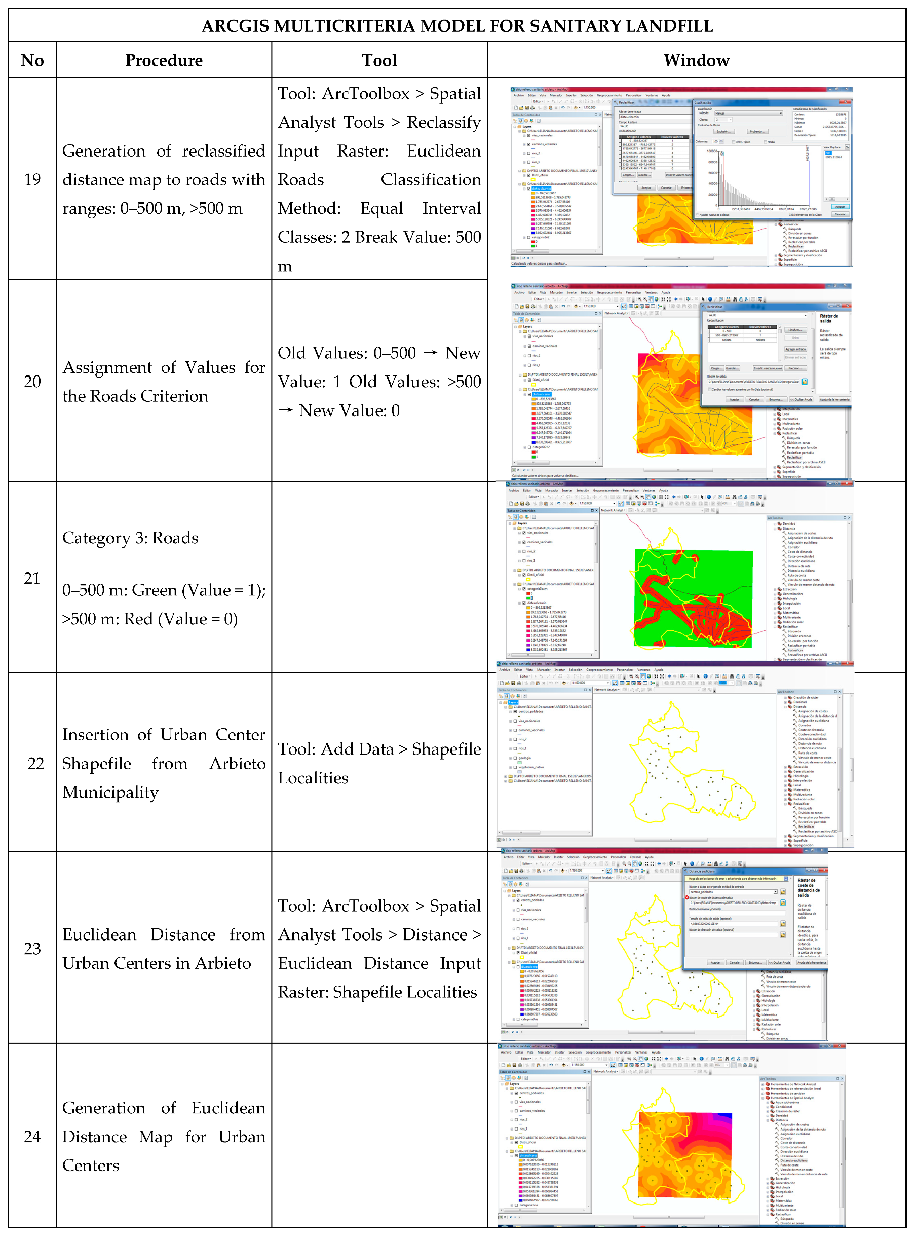
The results indicate that there are areas with high territorial suitability for constructing a sustainable sanitary landfill in Arbieto. This solution could significantly reduce soil and water contamination, improve public health, and align with sustainable development goals through an approach that combines technical, environmental, and social dimensions.
2. Materials and Methods
This study implemented a geospatial multicriteria decision-making (MCDM) methodology using ArcGIS to identify optimal locations for sanitary landfill siting in the municipality of Arbieto, Cochabamba, Bolivia. The method integrates environmental, technical, legal, and social criteria in a Boolean logic overlay model, ensuring equal weight for all variables.
2.1. Review of Technologies and Planning Approaches
To contextualize the proposed methodology, a literature review was conducted, focusing on best practices for siting landfills using Geographic Information Systems (GIS), multicriteria evaluation, and alternative disposal technologies. Key studies included landfill planning strategies using AHP and GIS (Barros et al. [1]), weighted overlay mapping (Bera et al. [2]), and multicriteria evaluation in African contexts (Ampofo et al. [3]). Additional examples of landfill siting using multicriteria methods in Bolivia and other developing countries were also reviewed (Quinteros et al. [6], Biazen Molla [7], Arabeyyat et al. [8]). Furthermore, recent advances in leachate treatment and waste valorization strategies were considered (Cheniti et al. [4], Kerboua et al. [5]).
2.2. Study Area and Data Collection
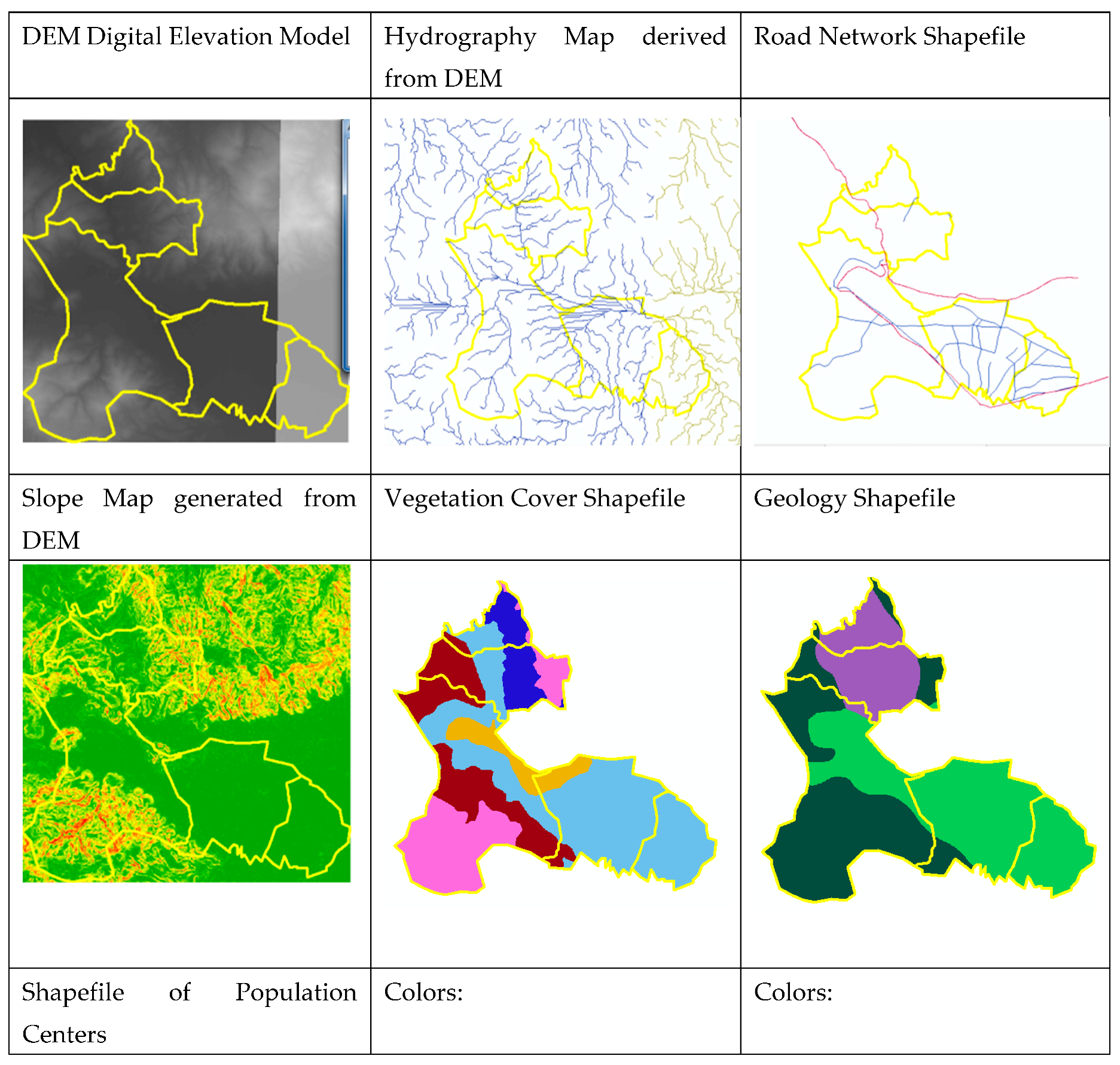
The municipality of Arbieto comprises seven districts and 67 communities. Data layers were acquired from the PTDI of Arbieto and the Instituto Geográfico Militar (IGM). The following shapefiles were used:
- -
- Digital Elevation Model (DEM)
- -
- Hydrography (rivers and water bodies)
- -
- Road network (secondary and tertiary)
- -
- Urban and rural population centers
- -
- Geological formations
- -
- Vegetation cover (classified from Landsat imagery)
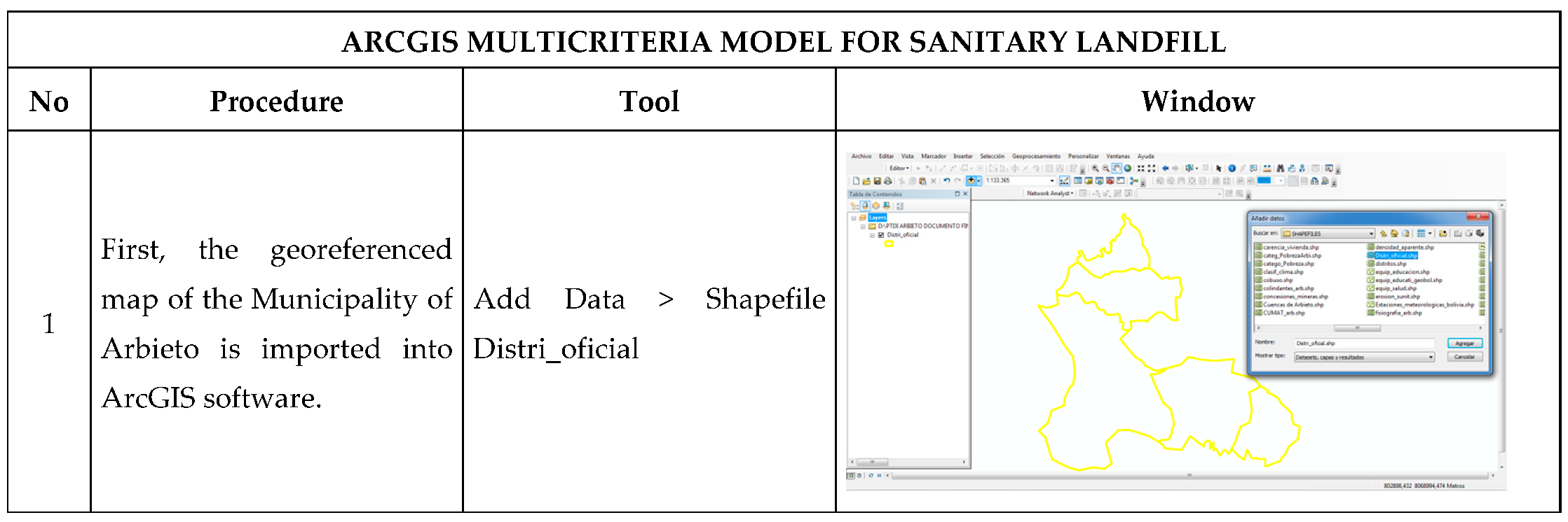
Figure 1 shows the shapefile of the Map of the Municipality of Arbieto inserted into the ArcGIS software, as the starting point for adding the other shapefiles required for the multicriteria model for sanitary landfill site selection.
Table 1 presents the maps and shapefiles required to apply the Multicriteria Model for the selection of a final disposal site for municipal solid waste.
2.3. Multicriteria Criteria and Processing in ArcGIS
Six critical variables were defined: slope, distance to rivers, distance to roads, distance to settlements, geology, and vegetation cover. Each layer was standardized and reclassified into binary values: 1 = suitable, 0 = unsuitable. Suitability thresholds were defined based on Bolivian technical norms and international literature:
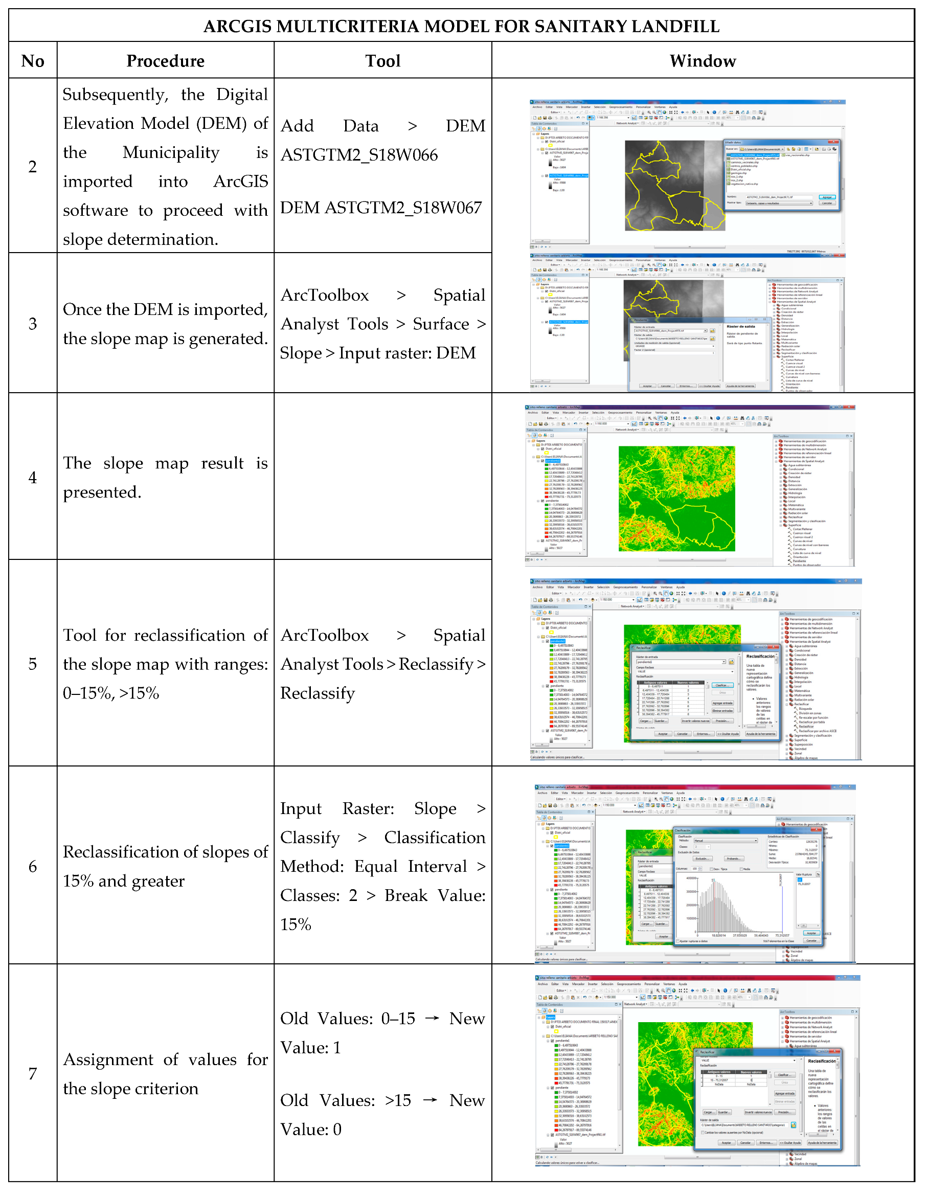
Slope: Areas with a slope between 4° and 15° were considered suitable.
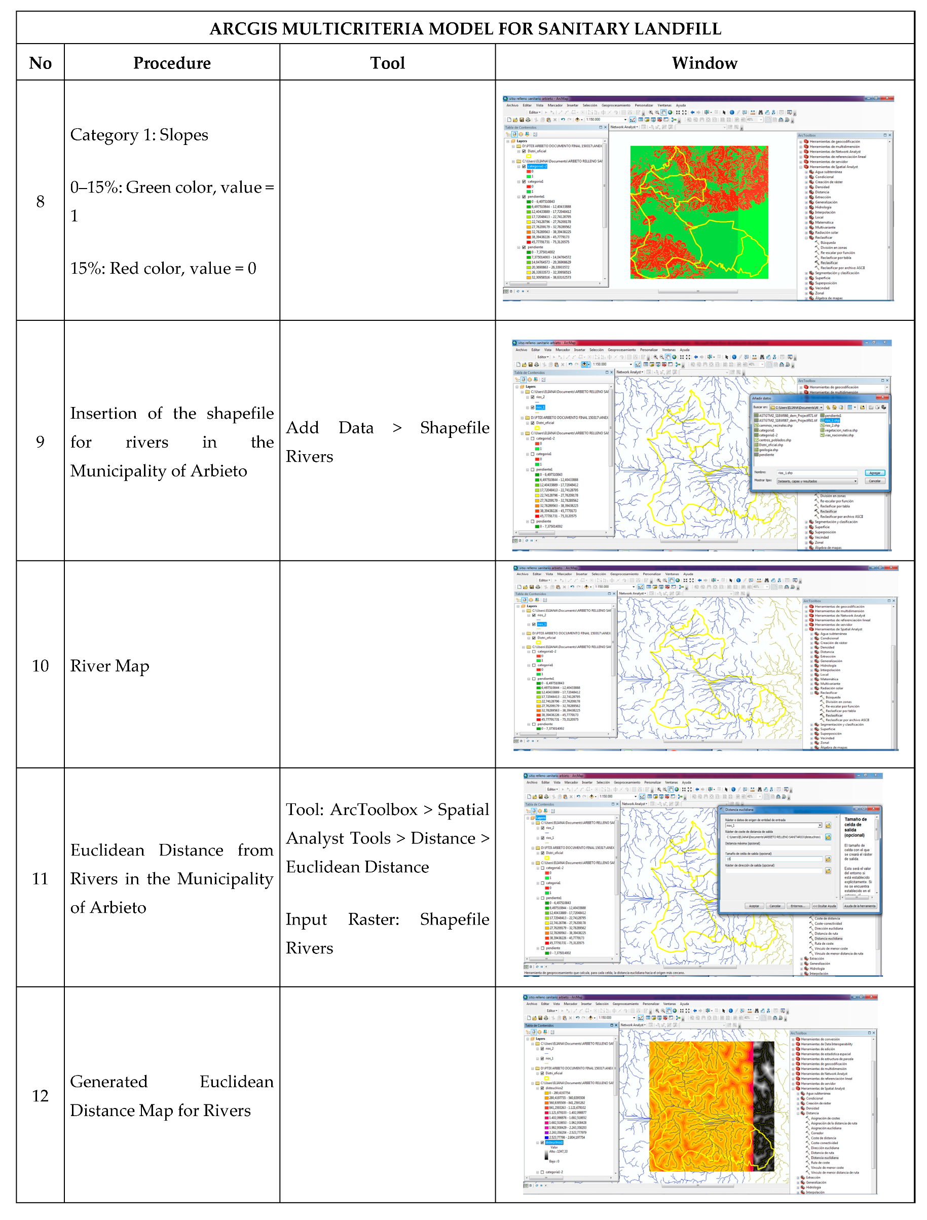
Hydrology: A buffer of 500 m was applied to all surface water bodies to avoid contamination.
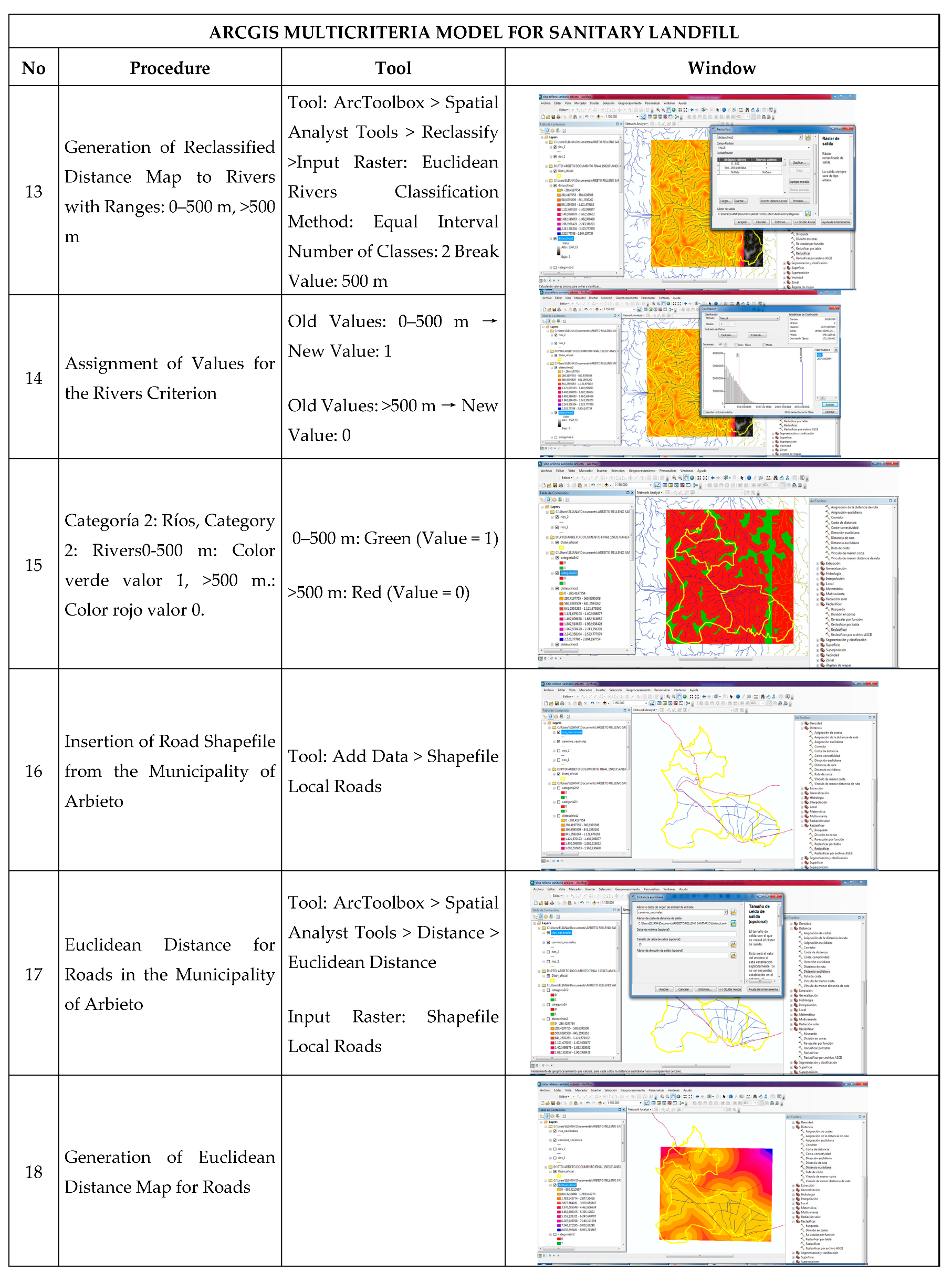
Road Access: Sites located more than 500 m from main roads were favored, balancing access and impact mitigation.
Proximity to Settlements: A minimum distance of 500 m from populated centers was established to prevent health risks.
Geology: Stable, low-permeability geological formations were preferred.
Land Cover: Areas without significant vegetation or agricultural activity were prioritized.
where is the value of criterion i at the spatial point

Table 2.
Criteria for Sanitary Landfill Site Selection.
| Criterion 1: Slope | Criterion 2: Hydrology | Criterion 3: Access Roads | Criterion 4: Population Centers | Criterion 5: Vegetation Cover | Criterion 6: Geology | Value |
|---|---|---|---|---|---|---|
| <15o | >500 m | >500 m | >500 m | Fam. Apacheta, Condorsinga, Cercapuquio, Volcanic Center, Antarazo, Subvolcanic Rocks, Andesite/Diabase, Dacite/Rhyodacite, Fam. Astobamba, Chambara, Sacsaquero, Castrovirreyna. | Area without vegetation, semi-humid scrubland, humid scrubland, grassland. | 1 |
| >15o | <500 m | <500 m | <500 m | Fam. Chulec-Pariatambo, Chayllacatana, Goyllarisquisga, Casapalca, Auquivilca, Caudalosa, Huando, Huichinga, Santa Barbara, Andesite/Diabase, Apacheta, Wetland Deposits, Glaciers, Urban Areas. | Urban areas, wetlands, agricultural cultivation areas, glaciers, lakes, rivers, forest plantations. | 0 |
Source: Own elaboration based on GEO GISS [9].
The final suitability is obtained through the logical intersection of all considered criteria. Each spatial layer was transformed into a binary map (1 = meets the criterion, 0 = does not meet the criterion) using ArcGIS tools such as Slope, Euclidean Distance, Reclassify, and Raster Calculator. Layers were combined using a Boolean overlay method The final suitability was calculated as:
A final value of indicates that the location is suitable for final disposal according to all criteria, while a single value of 0 in any layer excludes the site.
where represents the final suitability at point and Cᵢ are the binary criteria. Only cells with a value of 1 in all layers were considered suitable.
Table 3.
Procedure for Sanitary Landfill Site Selection Using the Multicriteria Model.
 |
 |
 |
 |
 |
 |
 |
 |
2.4. Model Workflow
Importation of shapefiles (DEM, roads, rivers, settlements, geology, vegetation)
Generation of slope layer (Slope tool)
Euclidean Distance for rivers, roads, and settlements
Reclassification into binary raster layers (Reclassify tool)
Raster overlay via Raster Calculator to generate final suitability map
Exportation of final map in raster and shapefile formats for validation and visualization.
2.5. Optimization with GAMS
To complement spatial analysis, the General Algebraic Modeling System (GAMS) was used to optimize transportation routes and costs from 20 waste generation sources. The optimization function minimized operational and environmental costs, facilitating efficient allocation of resources for future landfill management.
2.6. Validation
2.7. Declaration of AI Use
No generative artificial intelligence (GenAI) was used in the generation of data, analysis, or interpretation. AI tools were used only for editing and proofreading support.
2.8. Data Availability
All spatial layers used in this study are publicly available through the PTDI of Arbieto and the Instituto Geográfico Militar (IGM). DEM data were obtained from ASTGTM2 tiles S18W066 and S18W067.
2.9. Ethical Considerations
This study did not involve human or animal subjects and therefore did not require ethical approval. The approach outlined ensures transparency, replicability, and adaptability to other municipalities with similar territorial and institutional constraints.
3. Results
This section presents the results of the multicriteria model developed for the sanitary landfill site selection in the Municipality of Arbieto, Cochabamba, using ArcGIS software.
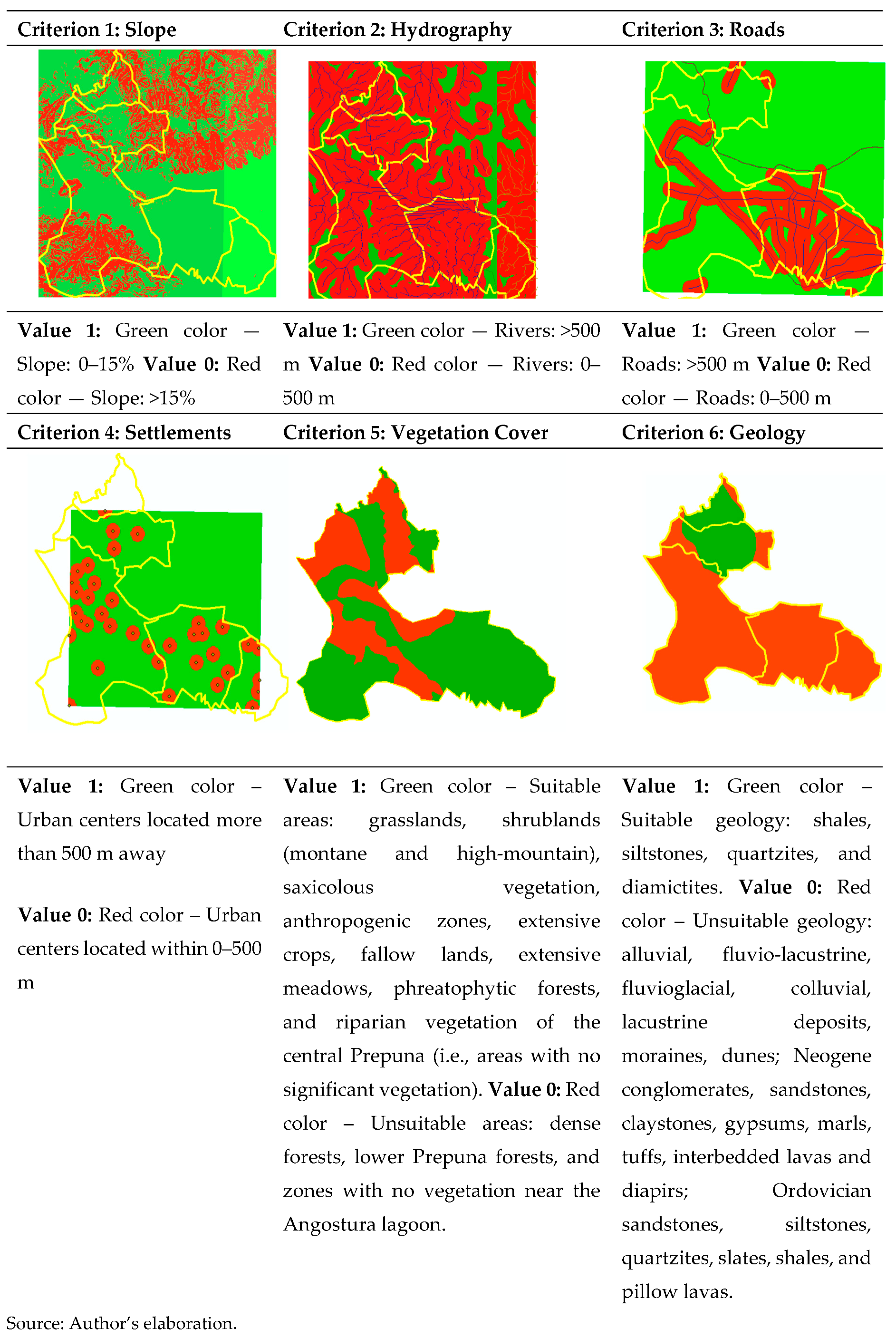
3.1. Individual Criterion Mapping
The multicriteria analysis evaluated six critical factors: slope, proximity to rivers, proximity to roads, proximity to settlements, vegetation cover, and geological stability. Each factor was processed into binary suitability layers (1 = suitable; 0 = unsuitable) according to defined thresholds.
Table 4 summarizes the classification criteria for each variable.
Criterion 1. Slope: Areas with slopes <15° were classified as suitable (green, value = 1); areas >15° as unsuitable (red, value = 0).
Criterion 2. Distance to rivers: >500 m suitable (green); <500 m unsuitable (red).
Criterion 3. Distance to roads: >500 m suitable (green); <500 m unsuitable (red).
Criterion 4. Distance to settlements: >500 m suitable (green); <500 m unsuitable (red).
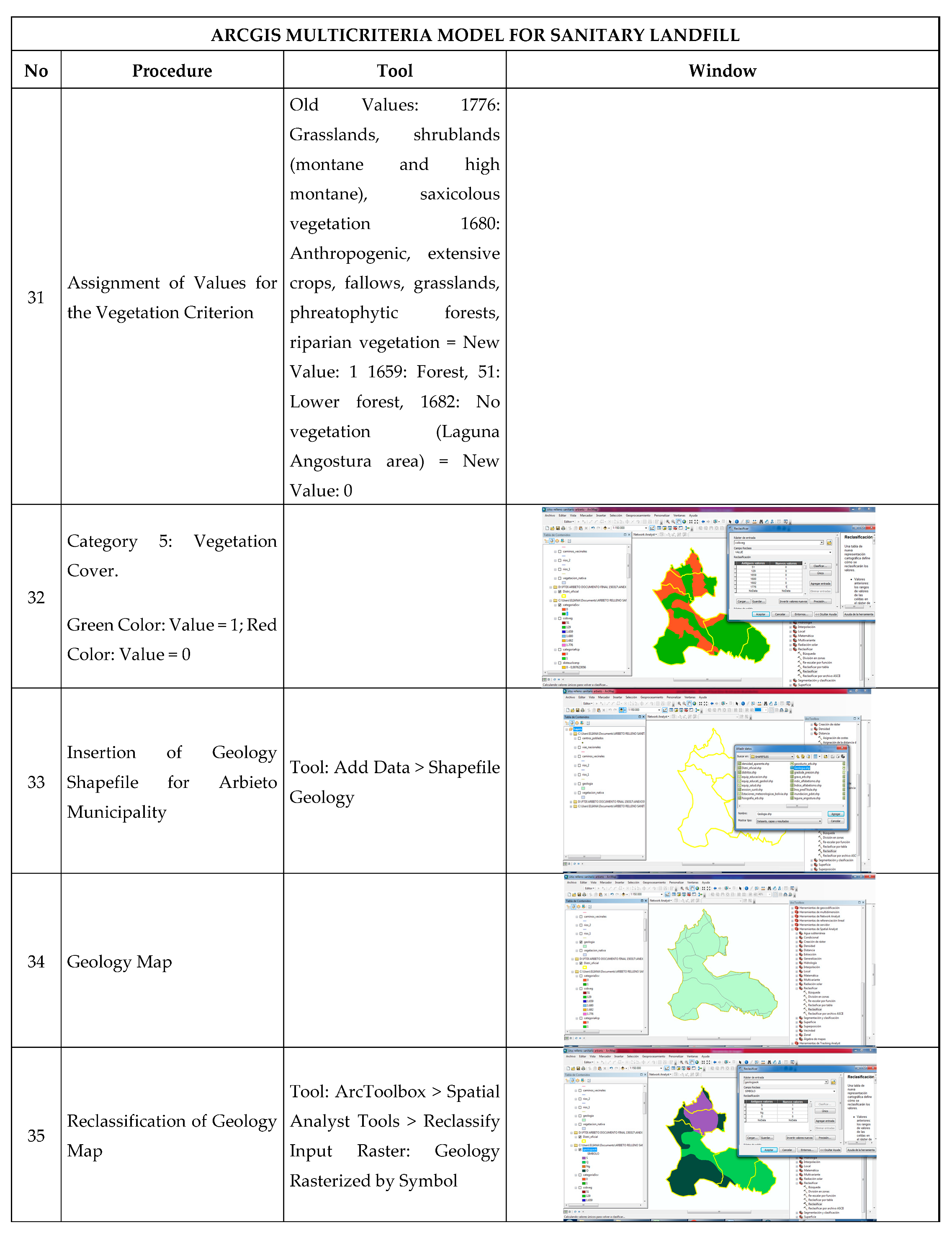
Criterion 5. Vegetation cover: disturbed land, shrublands, and grasslands considered suitable (green); forests and wetlands unsuitable (red).
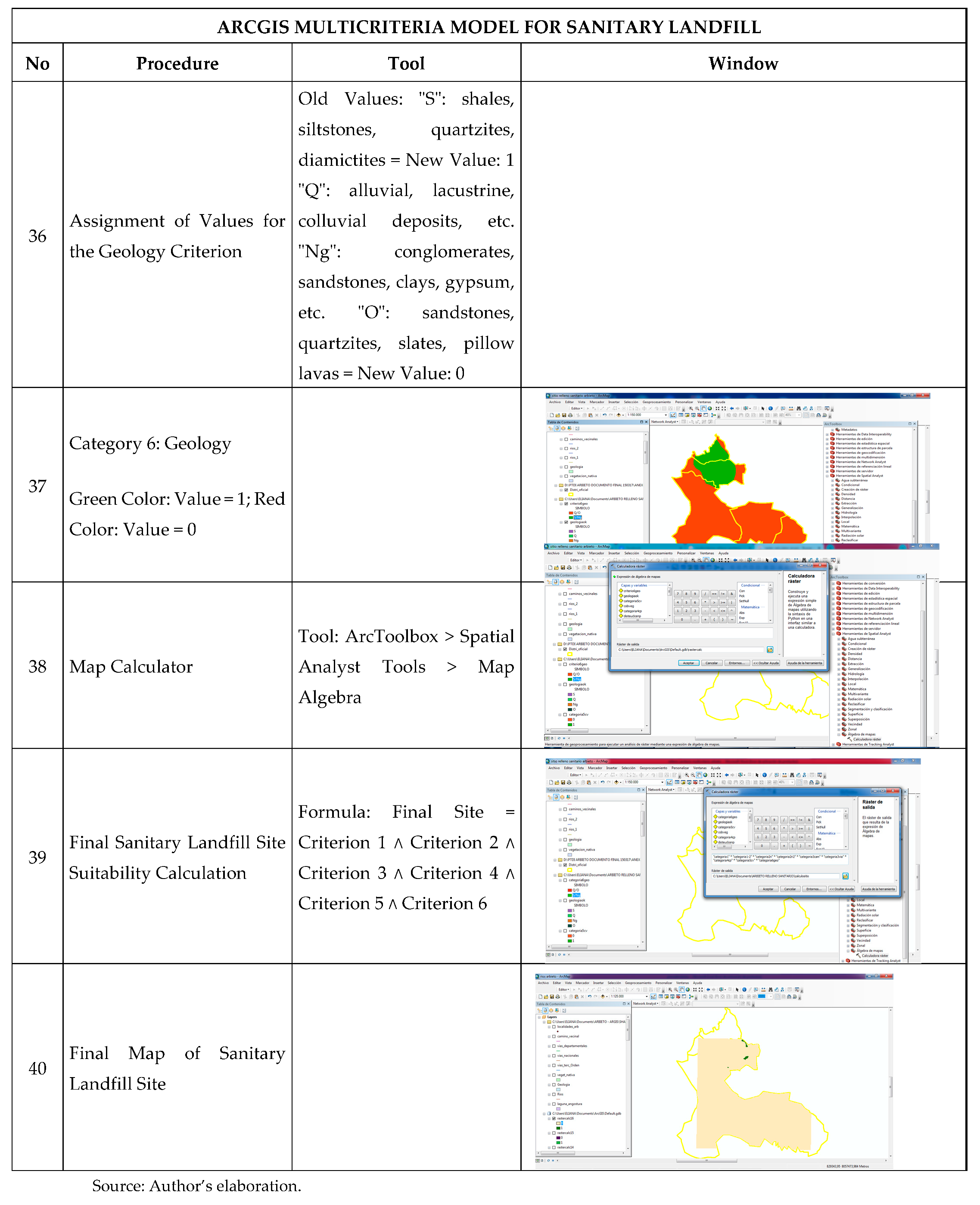
Criterion 6. Geology: stable formations with low permeability were suitable (green); permeable or unstable formations were unsuitable (red).
3.2. Final Suitability Mapping
The final suitability map was obtained by applying a Boolean intersection of all criteria layers, These criteria were integrated into a single Boolean overlay model using the following equation, as described by Equation (1):
where represents the final suitability at location , and each is a binary criterion layer.
Only cells satisfying all criteria (value = 1) were selected as suitable landfill sites.
Figure 2.
Final suitability map identifying optimal landfill locations (ArcGIS raster output). Source: Author’s elaboration.
Figure 2.
Final suitability map identifying optimal landfill locations (ArcGIS raster output). Source: Author’s elaboration.
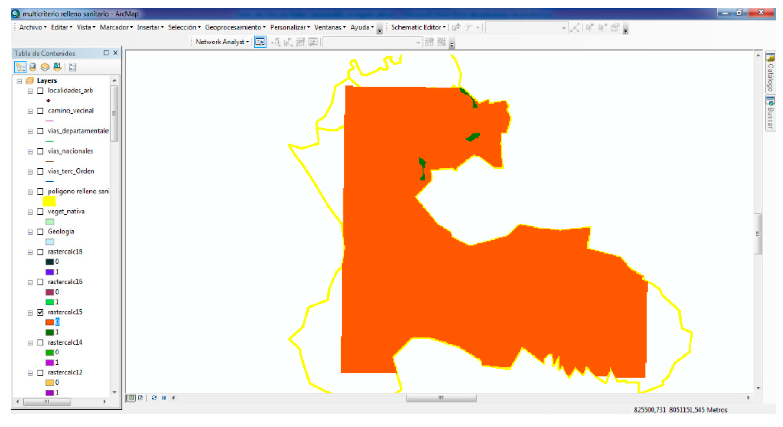
In Figure 3, the results of the final solid waste disposal site selection are presented using a satellite map. This visual representation illustrates the optimal zones identified through the multicriteria model, highlighting suitable areas for the future sanitary landfill in the municipality of Arbieto.
3.3. Site Alternatives Identified
Three candidate sites were identified as suitable for sanitary landfill development:
Table 5.
Landfill Site Alternatives Identified.
| Site | Easting (m) | Northing (m) | Area (m²) | Area (m²) |
|---|---|---|---|---|
| Site 1 | 812367.00 | 8061779.00 | 149,795.25 | 14.98 |
| Site 2 | 810050.00 | 8060550.00 | 13,274.12 | 1.33 |
| Site 3 | 812364.00 | 8063307.00 | 132,105.58 | 13.21 |
Source: Author’s elaboration.
All identified sites are located in District 5, within the communities of Olimpo and Tackoloma, in the Municipality of Arbieto.
3.5. Interpretation
The findings confirm that, despite the municipality's challenging topography and environmental constraints, there are viable sites for the establishment of a sanitary landfill. Specifically, Site 1, with an area of 14.98 ha, presents the most favorable conditions due to its sufficient distance from water bodies, urban areas, and its stable geological features.
The application of a Boolean logic multicriteria model ensures transparency, objectivity, and replicability, providing a robust decision-making tool for future waste management planning in Arbieto.
The Municipality of Arbieto covers a total area of 15,967.75 hectares. Based on the multicriteria spatial analysis, three potential sites were identified as optimal locations for a future sanitary landfill. Among them, Site 1 (14.98 ha) and Site 3 (13.21 ha) present the most favorable areas for future waste disposal infrastructure, while Site 2 (1.33 ha) offers a smaller but technically suitable alternative.
These results provide a technically grounded foundation for advancing towards the planning, design, and implementation of a sanitary landfill system, ensuring environmental protection, public health, and compliance with international standards.
4. Discussion
The selection of the optimal site for the final disposal of solid waste in the municipality of Arbieto was carried out by applying a multicriteria analysis model within a GIS environment, where each variable was reclassified into a binary format (value 1 if the criterion was met, value 0 if not). The criteria included slopes lower than 15°, distances greater than 500 meters from rivers, roads, and population centers, the presence of stable geological formations, and areas with minimal or no vegetation cover. Subsequently, a Boolean overlay technique was applied in ArcGIS by multiplying all the layers that simultaneously met the defined criteria. Thus, only the areas with a value of 1 across all layers were identified as potentially suitable zones for the construction of a sanitary landfill.
The results demonstrated that the optimal location for the future sanitary landfill is concentrated in the northern part of the municipality, specifically in District 5, within the communities of Olimpo and Tackoloma, at UTM coordinates 812367.00 m E, 8061779.00 m N. These findings confirm the working hypothesis that a multicriteria analysis methodology within a GIS environment would allow the identification of technically, environmentally, and socially appropriate areas for final waste disposal in rural contexts such as Arbieto.
When compared with international studies, the results are consistent with those reported by Bera et al. [2] in India, Ampofo et al. [3] in Ghana, and Barros et al. [1] in Brazil, where Boolean and multicriteria overlay models were also applied for landfill siting in rural or peri-urban territories. Similar to those studies, the use of GIS tools enabled the efficient management of multiple technical, environmental, and social criteria, contributing to a more objective and replicable planning process.
The identification of suitable areas in Arbieto highlights the importance of proactively planning the integrated management of solid waste by prioritizing the acquisition and protection of suitable land for sanitary landfills. Therefore, it is essential for the Autonomous Municipal Government of Arbieto to manage the legalization of the selected plots, prevent future illegal settlements, and guarantee their exclusive use for technical waste disposal. Additionally, it will be crucial to implement socialization processes with local communities to ensure social acceptance of the project and strengthen participatory governance.
Finally, for future research directions, it is recommended to incorporate dynamic scenario analyses of urban growth and population expansion, as well as to evaluate complementary alternatives such as transfer stations, waste valorization facilities, and waste generation minimization strategies. Furthermore, the model could be enhanced by integrating multicriteria weighting methods like the Analytic Hierarchy Process (AHP) for more complex scenarios or by including more detailed environmental impact simulations based on pollutant dispersion models.
5. Conclusions
The methodology applied through the use of ArcGIS software and the review of relevant literature enabled the selection of suitable sites for the final disposal of municipal solid waste in the municipality of Arbieto. By applying defined selection criteria, it was possible to identify specific areas that should be protected from illegal settlements to ensure proper integrated solid waste management.
Historically, the final disposal of waste in Arbieto has been conducted through open dumps, burning, or burial of waste across all districts, leading to serious social issues, environmental contamination, and public health risks. If no corrective measures are taken, these problems will intensify in the short term due to population growth and urban expansion.
The diagnostic process, based on GIS data and maps obtained from the PTDI of Arbieto and processed through ArcGIS, provided a clear identification of zones suitable for final waste disposal. The analysis of shapefiles related to topography, hydrography, road networks, population centers, geology, and vegetation cover allowed the pinpointing of the most appropriate locations for establishing a sanitary landfill.
Urban sprawl and informal settlements have placed increasing pressure on the local environment, causing significant land-use changes and generating further risks to public health. Soil contamination from improperly managed solid waste remains a critical issue in the municipality, underscoring the urgent need for an integrated waste management system beginning with the selection of an appropriate final disposal site.
Moreover, community education and environmental awareness campaigns conducted alongside the technical work constitute a key contribution. In the short to medium term, these actions are expected to foster concrete environmental protection measures and promote sustainable practices among the local population.
6. Patents
No patents have resulted from the work reported in this manuscript.
Author Contributions
Conceptualization, E.T.A.; methodology, E.T.A.; software, E.T.A.; validation, E.T.A.; formal analysis, E.T.A.; investigation, E.T.A.; resources, E.T.A.; data curation, E.T.A.; writing—original draft preparation, E.T.A.; writing—review and editing, E.T.A.; visualization, E.T.A.; supervision, E.T.A.; project administration, E.T.A. All authors have read and agreed to the published version of the manuscript.
Funding
This research received no external funding.
Institutional Review Board Statement
Not applicable.
Informed Consent Statement
Not applicable.
Data Availability Statement
The spatial layers used in this study are publicly available from the Plan Territorial de Desarrollo Integral (PTDI) of Arbieto and the Instituto Geográfico Militar (IGM). The DEM data were obtained from the ASTGTM2 tiles S18W066 and S18W067.
Acknowledgments
The author would like to thank the Municipal Government of Arbieto for access to geographic information and the institutional support provided during field visits.
Conflicts of Interest
The author declares no conflict of interest.
Abbreviations
The following abbreviations are used in this manuscript:
| MSW | Municipal Solid Waste |
| GIS | Geographic Information Systems |
| DEM | Digital Elevation Model |
| PTDI | IntegralComprehensive Territorial Development Plan |
| MCDM | Multicriteria Decision Making |
Appendix A.
Appendix A.1. Procedure for Multicriteria Analysis in ArcGIS
The step-by-step procedure for performing the multicriteria analysis for sanitary landfill site selection in ArcGIS is presented below:
Table A1.
Procedure for Multicriteria Analysis in ArcGIS.
| Step | Procedure Description | Tool Used | ArcGIS Menu |
|---|---|---|---|
| 1 | Load the georeferenced map of Arbieto municipality | Add Data | Shapefile Distri_oficial |
| 2 | Load the Digital Elevation Model (DEM) | Add Data | DEM ASTGTM2_S18W066, DEM ASTGTM2_S18W067 |
| 3 | Generate the slope map from DEM | Slope | ArcToolbox > Spatial Analyst Tools > Surface > Slope |
| 4 | Reclassify slope map (0–15% = 1; >15% = 0) | Reclassify | ArcToolbox > Spatial Analyst Tools > Reclassify |
| 5 | Load rivers shapefile | Add Data | Shapefile Rivers |
| 6 | Create Euclidean distance map from rivers | Euclidean Distance | ArcToolbox > Spatial Analyst Tools > Distance > Euclidean Distance |
| 7 | Reclassify distance to rivers (>500m = 1; ≤500m = 0) | Reclassify | ArcToolbox > Spatial Analyst Tools > Reclassify |
| 8 | Load road network shapefile | Add Data | Shapefile Local Roads |
| 9 | Create Euclidean distance map from roads | Euclidean Distance | ArcToolbox > Spatial Analyst Tools > Distance > Euclidean Distance |
| 10 | Reclassify distance to roads (>500m = 1; ≤500m = 0) | Reclassify | ArcToolbox > Spatial Analyst Tools > Reclassify |
| 11 | Load population centers shapefile | Add Data | Shapefile Localities |
| 12 | Create Euclidean distance map from population centers | Euclidean Distance | ArcToolbox > Spatial Analyst Tools > Distance > Euclidean Distance |
| 13 | Reclassify distance to population centers (>500m = 1; ≤500m = 0) | Reclassify | ArcToolbox > Spatial Analyst Tools > Reclassify |
| 14 | Load vegetation cover shapefile | Add Data | Shapefile Native Vegetation |
| 15 | Reclassify vegetation cover (no vegetation, grasslands, shrublands = 1; forests = 0) | Reclassify | ArcToolbox > Spatial Analyst Tools > Reclassify |
| 16 | Load geology shapefile | Add Data | Shapefile Geology |
| 17 | Reclassify geological formations (stable formations = 1; unstable formations = 0) | Reclassify | ArcToolbox > Spatial Analyst Tools > Reclassify |
| 18 | Perform raster overlay (logical intersection) | Raster Calculator | ArcToolbox > Spatial Analyst Tools > Map Algebra > Raster Calculator |
| 19 | Generate final suitability map | Raster Overlay | Result of logical AND operation |
| 20 | Export final map in raster and shapefile formats | Export Data | ArcGIS Output Options |
References
- Barros, A.P.; Silveira, J.R.; Cândido, G.A. Geoprocessing and multicriteria analysis for landfill site selection in Brazil. Environmental Science and Pollution Research 2024, 31, 21387–21401. [Google Scholar] [CrossRef]
- Bera, S.; Ahmad, S.; Lal, R. Site suitability for solid waste disposal using GIS: A case study of Ranchi, India. The Egyptian Journal of Remote Sensing and Space Science 2018, 21, 61–69. [Google Scholar] [CrossRef]
- Ampofo, S.; Adams, M.; Appiah, D.O.; Darkwah, J.A. Landfill site selection in Bolgatanga, Ghana using GIS and AHP. Environmental Challenges 2023, 11, 100723. [Google Scholar] [CrossRef]
- Cheniti, T.; Aissa, M.; Loukil, S.; Ferchichi, M.; Gargouri, I. Landfill leachate treatment and valorization: Advances and challenges. Journal of Environmental Management 2024, 332, 117430. [Google Scholar] [CrossRef]
- Kerboua, N.; Djemai, M.; Bouaicha, F.; Amrane, A. Valorization of municipal solid waste for energy recovery and leachate remediation. Renewable and Sustainable Energy Reviews 2024, 185, 113630. [Google Scholar] [CrossRef]
- Quinteros, L.; Nina, D.; Mamani, P.; Cossio, E. Aplicación de SIG y análisis multicriterio para la selección de sitios de disposición final de residuos sólidos urbanos. Revista Boliviana de Ciencias Ambientales 2020, 47, 15–29. [Google Scholar]
- Biazen Molla, S. GIS-based landfill site selection using MCDM for municipal solid waste management: A review. Environmental Challenges 2024, 12, 100787. [Google Scholar] [CrossRef]
- Arabeyyat, H.; Elhag, A.; Shbool, M.A.; Al-Harahsheh, A. Landfill site selection using GIS-based multicriteria analysis: A case study from Jordan. Environmental Monitoring and Assessment 2024, 196, 366. [Google Scholar] [CrossRef]
- GEO GISS. Selection of Landfill Sites Using GIS and Multicriteria Analysis: A Technical Report. GEO GISS Consultancy 2023, Unpublished report.
Figure 1.
Map of the Municipality of Arbieto in ArcGIS Software. Source: Author’s elaboration.
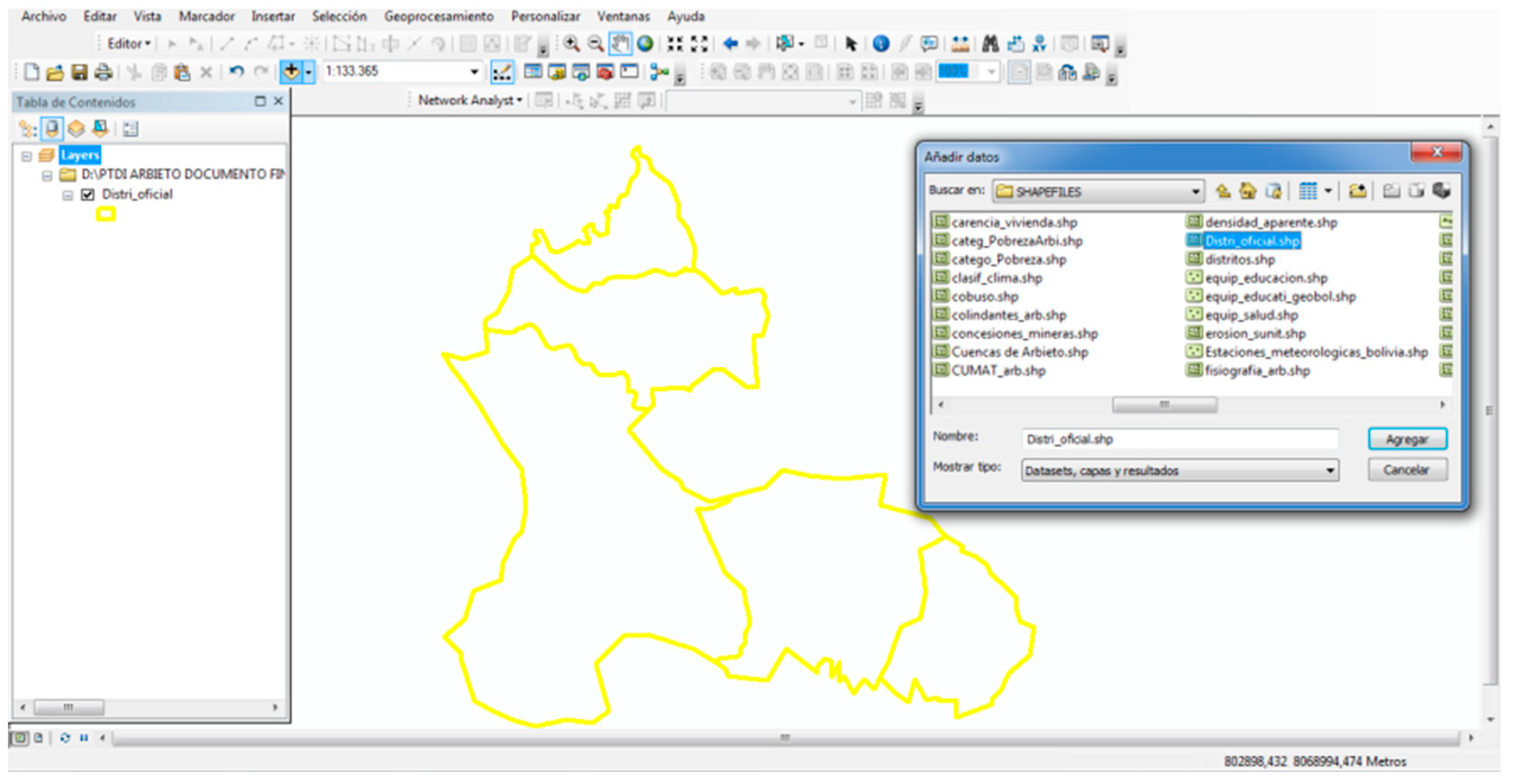
Figure 3.
Satellite map of the final landfill site selection. Source: Author’s elaboration.

Table 1.
Maps and shapefiles required for applying the Multicriteria Model for final disposal site selection of solid waste.
Table 1.
Maps and shapefiles required for applying the Multicriteria Model for final disposal site selection of solid waste.
 |
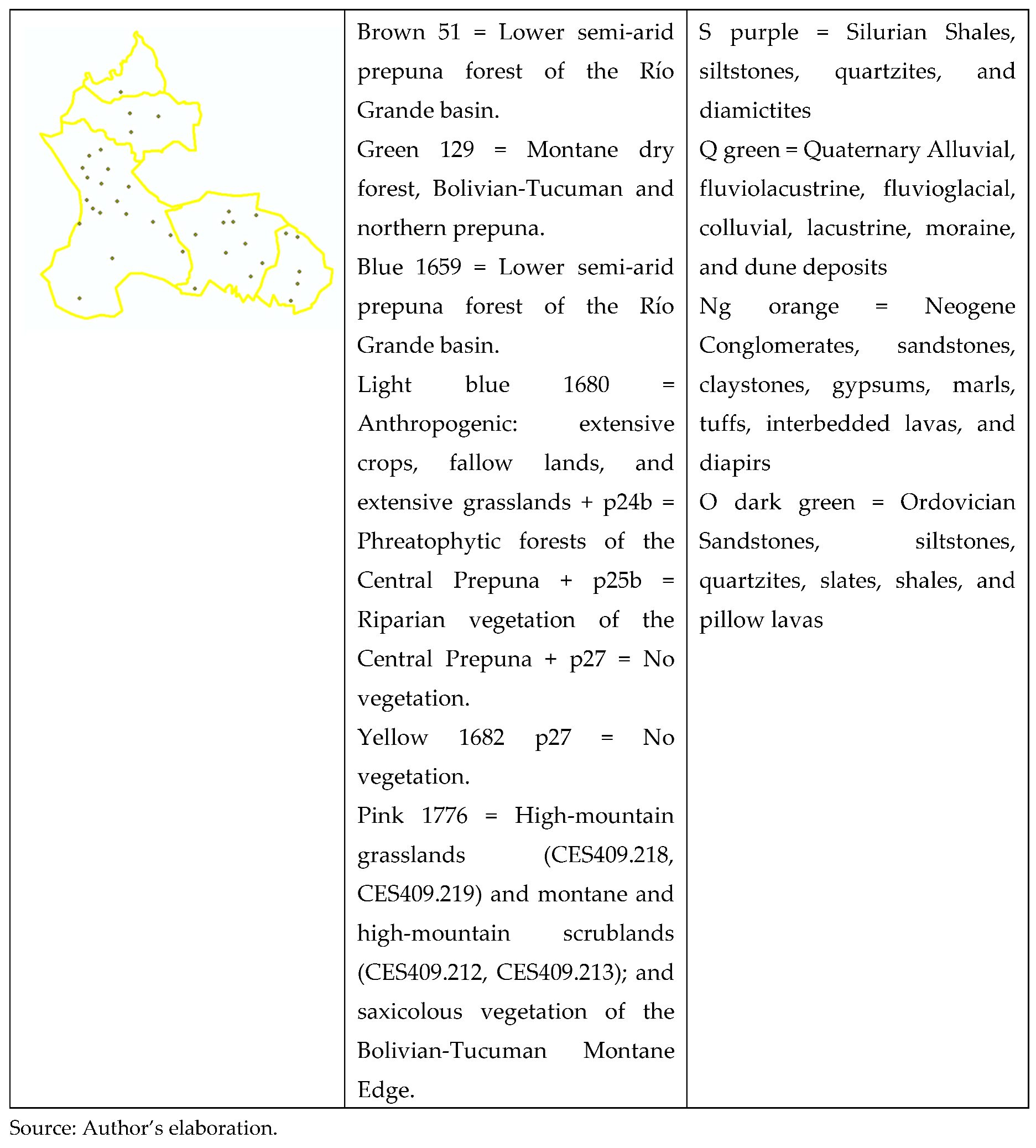 |
Table 4.
Criteria Results for Sanitary Landfill Site Selection.
 |
Disclaimer/Publisher’s Note: The statements, opinions and data contained in all publications are solely those of the individual author(s) and contributor(s) and not of MDPI and/or the editor(s). MDPI and/or the editor(s) disclaim responsibility for any injury to people or property resulting from any ideas, methods, instructions or products referred to in the content. |
© 2025 by the authors. Licensee MDPI, Basel, Switzerland. This article is an open access article distributed under the terms and conditions of the Creative Commons Attribution (CC BY) license (http://creativecommons.org/licenses/by/4.0/).
Copyright: This open access article is published under a Creative Commons CC BY 4.0 license, which permit the free download, distribution, and reuse, provided that the author and preprint are cited in any reuse.


