
Submitted:
24 March 2025
Posted:
26 March 2025
You are already at the latest version
Abstract
The Hellenic Cadastre, which is expected to be fully operational by the end of 2025, represents a major modernisation step in Greece's technical and legal documentation of property rights as the successor to the country's land registries system. It will also constitute a land administration system, since it will encompass not only property rights but also restrictions and regulations in the context of RRR. A significant technical but also legal challenge inherent to this system pertains to the resolution of deviations between surfaces calculated prior to 1990 based on older geodetic reference systems, and recalculated today using the current GGRS87 reference system. Deviations that arise from geodetic transformations between older and modern projected reference systems and are compounded by limitations inherent in historical surveying techniques and in the geodetic infrastructure that was available at the time. To address this issue, we introduce the Local Area Distortion Factor (LADF), a novel metric factor designed to adjust and harmonise property areas across different geodetic systems. This real-world case study offers a practical illustration of the application of LADF, demonstrating its capacity to enhance the precision of cadastral records while preserving interpretability for both experts and non-experts. LADF can also be used to improve land adjustment processes during the implementation of urban plans, property valuation, taxation and notary acts that are in different reference systems.
Keywords:
local area distortion factor
; cadastre
; area calculation
; area distortionq geodetic datums
; Greece
1. Introduction
The calculation of the area of a parcel or plot is a critical component in numerous technical and economic activities and mainly real estate exploitation, urban and spatial planning and the overall development strategies in local, regional and state-wide level. Apart its purely mathematical nature, the determination of properties area is significantly important in legal systems worldwide, as it directly influences property determination, land valuation and consequently the exercise of property rights, urban and spatial planning and the overall development strategies.
Deviations in property area calculation are primarily rooted in technical challenges encountered within the disciplines of land surveying and geodesy. While similarities and patterns can be identified across these challenges, they are often deeply tied to specific national technical and legal contexts. Thus, scientific knowledge and best practices exchange, is limited and hindered by a number of factors such as the technical complexity of the issue especially in the aspect of geodetic coordinate systems and diversification of survey techniques over time, variations in property legislation and legislation on regulations and restrictions imposed to properties, and differences in cadastral, urban and spatial planning legal framework and implementation.
The most prevalent factors contributing to deviations in the calculation of property area are:
- The misalignment between historical and modern geodetic coordinate systems, also exacerbated by the degradation of older geodetic infrastructure
- Distortions and wear observed in scanned historical survey/ cadastral/ urban plans, maps, diagrams
- Deviations between areas measured with modern techniques and geodetic datums and the equivalent areas referred in older titles as descriptive or qualitative entities not based on precise and analytical surveying and geodetic methods.
- Outdated cadastral information that does not conform to the current standards of surveying, geodesy and cadastral surveying.
It is therefore essential to develop innovative solutions, adapted to specific contexts, to enable accurate and consistent calculation of property area in the cadastral system, in order to resolve inconsistencies between cadastral records and various administrative acts or titles that are recorded in the land registry but lack an accurate spatial reference. [1,2,3,4].
Several studies have modeled the error propagation resulting from boundary measurement using "traditional" and GNSS surveying techniques to calculate the property area. [5,6,7]. Other researchers have advocated for more robust integration of uncertainty metrics into property area estimation [8,9,10,11,12] or propose new indices [13]. Research also focuses on the georeferencing of older cadastral maps to contemporary reference systems [14,15,16] which combine field measurements to recover lost geodetic control points so as to facilitate localized transformations of historical maps. Finally, there are studies with a more specialized goal, such as estimating the true area of a property, taking into account projective distortions, map scale, terrain slope, and elevation [17], and the investigation of area estimation inaccuracies on real estate evaluation [18].
In Greece the Hellenic Cadastre (HC), is the national parcel-based cadastral system officially adopted in 1995. The cadastral survey for the creation of HC began in 1995. The HC is planned to be fully operational throughout the country by the end of 2025, while the cadastral survey will be completed within the operational HC, according to the latest legislation adopted in 2024.
The operational HC fulfils a dual role. Firstly, it entirely replaces the existing person-centered system of Land Registries (launched in 1856, but existing as public offices since the late 1830s), in which the spatial related to the legal documentation of properties (plots or land parcels) is incomplete and vague [2]. Secondly, it will serve as the primary tool for the pursuit of the rational organisation and sustainable development of Greece, as outlined in Law 2664/1998 on operational Hellenic Cadastre.
The HC is organized in a spatial data base correlated to a descriptive data base. As HC is a parcel-centered system its spatial DB records the properties spatial and geometrical data, whilst the descriptive BD records all legal and relevant data of the property, e.g. owner or beneficiary data, title data, etc. Each property, plot or land parcel, gets a unique code, the Code Number of National Cadastre, KAEK in Greek language, in both the spatial an descriptive DB.
According to Law 2664/1998, the operational HC is responsible for maintaining legal and technical information with the objective of accurately determining the boundaries of any real property, mainly plot or land parcel, located within Greece’s territory. HC ensures the publicity of all titles and relevant data and information that registers and records, safeguarding public faith of any bona fide, physical or legal person, who relies on its records. One of the main scopes of the HC is to facilitate urban, regional and overall spatial planning within Greece’s territory and to ensure sustainable development.
Based on six essential principles - parcel-based organization, verification of title (and other necessary spatial data/ information) legality, temporal priority of submissions, publicity of cadastral records, safeguarding public faith and open and interoperable cadastre - the HC constitutes a powerful land management system for Greece’s both public administration and private sector. The principle of open and interoperable cadastre guarantees that the HC records rights, regulations and restrictions, RRR, on properties, which are attributes of modern and integrated cadastral systems.
The registration of any property and property right in the HC, whether in the cadastral survey phase or the functional Cadastre phase, depends to an extremely important extent on historical topographic techniques. Techniques that were utilised to generate official charts, maps or diagrams that accompanied official administrative acts, such as governmental land distribution/redistribution for refugees and indigenous landless farmers, especially in the first half of the 20th century, the adoption and implementation of urban plans, expropriations, and the designation and protection of forest areas. It is important to note that official administrative acts are legally binding proving and securing property rights for both the State and natural/legal persons, and should be applied on the ground with use of analytical topography methods. Furthermore, these acts remain legally and spatially valid regardless of the year in which they were issued. The historical surveying techniques were also used for the production of topographic diagrams appended to titles or deeds drawn up by notaries and transcribed to the relevant land registry related to sell of plots or land parcels, plots or land parcels subdivision/consolidation diagrams, or land readjustment plans, that also produce valid legal rights upon their transcription, regardless of their spatial integrity.
Compared to contemporary surveying and topographic products, the spatial or geometric quality and accuracy of the equivalent historical products is not the optimal, as the historic surveying techniques and technologies used for their production are directly linked to national geodetic infrastructures and reference systems of past eras. The majority of property ownership titles were issued prior to the 1990, thus prior the adoption and implementation of the current geodetic reference system, GGRS87 (Greek Geodetic Reference System of 1987). This resulted in the definition of the property area, as it appears on the ownership title, on older geodetic datums, or even on no datum at all as in many cases topographic diagrams appended on ownership titles were not based on the official geodetic control points and official reference systems.
As a result, there are deviations between the area of a property as defined by its legal documentation, e.g. official administrative acts, titles or deeds transcribed in land registries, and calculated on the accompanying survey diagram, map or chart, and the corresponding area that is measured today using modern surveying technology and the updated reference systems of GGRS87.
The adoption of the HC as a more appropriate system for the spatial and descriptive documentation of properties, property rights and RRR in general than land registries, made the use of the GGRS87 mandatory, initially from 1995 for HC records and official administrative acts, and from 2011 for all acts, including topographic diagrams appended to titles or other legal documents and topographic diagrams for the issue of building permits.
In the case of official administrative acts deviations in property area calculation that arose between the GGRS87 and older official reference systems, in many cases render the acts invalid, either to non-integration of the act to the HC, or in the case the act is integrated to the HC, official administrative bodies, such as urban or spatial planning authorities and bodies, reject the concurrent record provided by the HC.
This paper introduces the Local Area's Distortion Factor (LADF) as a solution to the longstanding challenges of the deviations of properties area calculation between GGRS87 and older reference systems. The LADF introduces a robust and standardised adjustment mechanism that aligns old with contemporary geodetic datums, such as GGRS87, incorporating transformation parameters and distortion factors into a simple calculation.
This approach not only eliminates deviations in the calculation of property area between HC spatial records and older records, but also facilitates effective communication between stakeholders and experts, including urban planners, surveyors, notaries, lawyers and citizens involved in real estate transactions and exploitation, as it is easily understood.
2. Property Area Determination in Greece: A Brief Review
In Greece, the area of a property, land parcel or a plot, has substantial role in urban and regional planning, and overall development [19], whilst it is essential for titles and deeds transcribed to land registries or recorded in cadastral offices of the HC [2,19,20]. When the independence of Greece was finalized, in 1830, the then Greek State, known as the Kingdom of Greece, had to deal with the determination of the public lands, inherited from the Ottoman Empire, on the one hand, and the private lands owned by Ottomans who wanted to sell it to leave the state or by Greeks citizens on the other hand. The area of a property was calculated in number of “cattle-pairs”, with one cattle-pair corresponding to the area that can be cultivated by a pair of cattle in one year, with a general spatial reference to local landmarks and place names, for both public and private properties.
In 1834 and following the proclamation of Athens as the Capital of Greece, replacing Nafplio (located at the northeast part of Peloponnese), there was an imperative need for urban regeneration and urban development. In order to formulate and implement urban development plans, mainly in Athens and Syros Island, within the existing urban and peri-urban landscape, experts in urban planning and surveying, initially from Bavaria and subsequently from Greece, were recruited. Legislation on the implementation of Athens urban plan, enacted by two royal decrees in 1836, foreseen regularization and standarisation of plots, private or public, so as the necessary land could allocated to public roads, public spaces and common spaces so as to make them functional. This marked the first official procedure for the regularisation of landownership through the allocation of private to public land, named “boundary reform”, and overseen by city employed engineers. In 1852 and 1856 the construction of urban roads and urban infrastructure (pavements, sewage systems, etc.) was enacted by two laws, on roads construction and pavements construction, respectively, describing all the legal and administrative processes, but not in detailed spatial and geometric aspect, for parts of private land that need to be allocated for the creation of public and municipal roads and public spaces in general, forming new property rights for public and private properties that are valid till nowadays.
The establishment of the Hellenic Military Geographical Service (GYS) in 1889 initially as “Geodetic Mission” under the responsibility of Austrian army officers, in 1895 as the Hellenic Military Cartographic Service, and as HMGS in 1926, played a crucial role in establishing precision procedures in surveying, geodetic and other associated works. Under the HMGS the development of the official geodetic infrastructure of the country was implemented, whilst the Service had a key role in the optimisation of the methods of measuring both public and private property. The optimization measurement methods were of great importance especially for large private lands that gradually passed from Ottoman to Greek ownership from 1830 and onwards, as Greece kept succeeding the Ottoman Empire.
In the late 1880s the German Archaeological Institute in Attica initiated the creation of detailed maps, which were completed in 1903 under the supervision of Bavarian army officer Johann August Kaupert. The maps were of high accuracy, with topographic, cartographic and archaeological value, and also constituted the first systematic and accurate mapping of the urban, suburban and peri-urban/rural environment of Attica Prefecture. The Kaupert maps were produced using a geodetic network that was established by observations and measurements of spatial distances, direction angles and astronomical azimuths of its geodetic control points, with the fundamental control point being located at the National Observatory of Athens, near the Acropolis Hill, at Thissio.
At the same period with the production of the Kaupert maps, the Technical Department of the Directorate of Public Lands, Ministry of Finance was established. The creation of the department responded to the need of conserving, utilising or distributing public property, particularly national lands. Staffed mainly by engineers specialising in topography, the Department was responsible for surveying, documenting, and allocating national lands to beneficiaries, selected by the central administration, with legal and valid titles registered in the relevant land registry. In parallel the Department recorded the remaining public land.
In 1910 legislation enacted regarding the creation of “Cadastral Map”, that would cover all the then Greece’s territory, and would be undertaken by the Hellenic Military Geographical Service, through the densification of its then triangular network. The 1910 legislation of Cadastral Map was supplemented by legislation on “Cadastral Map for urban properties” in 1923, but the foreseen cadastral maps were conducted and finalised only fort two urban areas, Municipality of Kallithea and part of the Municipality of Paleo Falliro, located at the seaside front of Athens Greater Area.
In 1917, when the Ministry of Agriculture, which until then had been part of the Ministry of Finance, was established, the Survey Agency of the Ministry of Agriculture, SAMA, was established. Initially SAMA was part of the Technical Department of the Directorate of Public Lands of the Ministry of Finance, and in 1930, it became part of the Directorate of Technical Works of the Ministry of Agriculture. SAMA was the responsible agency for the successful completion of large-scale distributions of urban and agricultural land to over 1.500.000 Greek refugees that fled to Greece after minor Asia destruction in 1922 and of landless Greek citizens, especially in southern mainland Greece, mainly between 1920-1940. From 1950 onwards, in addition to distributions, SAMA has been carrying out large-scale redistributions which aim at the optimization of agricultural production.
The Agency’s distribution and redistribution activities are characterised by their large-scale and comprehensive nature, involving detailed and accurate geodetic, topographic, and cadastral procedures resulting in official topographic/ cadastral maps. The establishment of official geodetic networks facilitated the conduct of the topographic/ cadastral maps that were correlated to definitive governmental titles, for each beneficiary, transcribed to the relevant land registry, recognised as official administrative documents, of legal effect, in their entirety valid up today, regardless of their issuance date.
The 1922 refugees fled, also led also to the revision of the urban planning legislation. The necessity to re-organise existing urban space, and to provide new urban areas, via urban plan expansion, resulted to the enactment of the 1923 legislative decree on “urban plans”, that included specific procedures on plans production and implementation, including their spatial and geometrical aspect. Under the 1923 decree on “urban plans” numerous powerful administrative acts were issued, legally binding in spatial level, determining not only the geometrical characteristics of roads, and relevant public and common spaces, but also the area of private plots. These acts had to be applied in situ by private surveying engineers under the supervision of public authorities. This posed significant challenges, particularly in areas of high relief, where the calculation of geometric elements, especially the area of the property, proved to be a complex undertaking. The same prevailed in other official administrative acts, also legally binding on a spatial level, such as expropriations or the definition of the boundaries of seashore and beach borderlines, affecting the legal and spatial in definition of both private and public property, with these acts often not being referenced to the country’s official geodetic reference system.
By the early 1950’s, more precise methods were introduced in both land surveying (e.g. classical tacheometry) and area calculations. Areas were calculated using the Gauss method, which relied explicitly on boundary coordinate geometry, or measured with planimeters [21].
The advances of computers and Computer-Aided Design (CAD) programs in the early 1980s led to the predominance of digital area calculations based on vector-based geometries. This coincided with two major reforms in Greek legal framework: the prerequisite of detailed topographic diagram, appended in titles related to transactions on properties transcribed to the relevant land registry, enacted in 1977, and the obligation of the administration, of any level, to ensure the integration of legally binding administrative acts, to the country’s concurrent official geodetic reference system, after 1975.
However, a considerable proportion of topographic diagrams appended to property titles transcribed to land registries have varying accuracies, as it was not obligatory to be integrated to the official Reference System, GGRS87 after 1990, thus have limited metric and spatial quality. In 2011 when law 4014 was enacted, it foreseen that any topographic diagram appended to titles, transcribed to land registries or registered to cadastral offices, ought to be referenced to Greece’s official reference system, GGRS 1987.
In 1995 the transition from the land registries system to the Hellenic Cadastre operational system, through the completion of cadastral survey, was launched. This transition is considered a huge reform in properties spatial and descriptive documentation, in property law implementation and in the overall land administration procedures in Greece. For the cadastral survey phase for the creation of the HC the Cadastre SA, a public owned company, was created in 1995 under law 2308/1995, and in 1998 the company was responsible also for operational HC. In 2013 Cadastre SA was renamed to Hellenic Cadastre and Mapping SA (HCM SA), absorbing the Hellenic Cadastral and Mapping Organization, and in 2018 the HCM SA was replaced by the Hellenic Cadastre, as legal entity of public law. All HC spatial records are referenced to GGRS87, that is the official reference system of HC regardless of its phase (creation or operation).
In the spatial aspect all official administrative acts must be integrated into the HC, in GGRC87, and the same stands for every property deriving by legal documents, e.g. titles transcribed to land registries. Initially in the cadastral survey phase for the creation of HC and later the operational HC revealed numerous and serious spatial and geometrical inconsistencies amongst HC cadastral records, official administrative acts, and topographic diagrams appended to titles transcribed to land registries. As the integration to the HC of existing administrative acts, or topographic diagrams appended to titles was based on empirical methods, in many cases these inconsistencies can actually lead to the halt of transactions on properties or their exploitation [1].
3. Greek Geodetic Reference Systems and Property Area Calculation in Greece
It was not until 1990 that a new geodetic reference system, GGRS87, superseded the older GR-Datum system, which had previously been utilized for mapping and surveying in Greece, [22]. GR-Datum is comprised of two distinct versions that can be regarded as two different and separate geodetic datums, realized in different periods:
(a) The Old Version of GR-Datum (OVGRD): This was realized prior to 1940, utilizing the ellipsoid of Bessel 1841 and the azimuthal equidistant Hatt projection (e.g. [23]). The OVGRD aimed to fill the absence of a nationwide and official projected reference system, and mainly addressing the pressing demand for housing and agricultural land distribution that arose from the population exchange between Greece and Turkey, and the influx of refugees following the 1922 Minor Asia Catastrophe. Under the OVGRD Greece’s territory was divided into 132 1:100,000 map sheets, projected using Hatt's method. Each map sheet centre constituted its own local datum, thereby ensuring simple calculations and manageable map distortions (approximately 5 cm at map border edges).
(b) The New Version of the GR-Datum (NVGRD) was developed in mid 1970s. New measurements of existing geodetic control points were carried out, followed by the adjustment of the triangulation network. NVGRD also used the Bessel 1841 ellipsoid and two projections were used: - the Hatt projection that covered the whole country and was used in official administrative acts like expropriation or seashore boarder line determination,
- the tri-zonal TM3 projection (Traverse Mercator projection), exclusively used in the most significant urban planning reform initiated in 1983 under Law 1337/1983, for the expansion and modification of Urban Plans and included a legal binding and complete cadastral survey that defined each owner’s land contribution for the creation of public and common spaces as prerequisite for the implementation of the plan [24].
In 1986 the Hellenic Cadastral and Mapping Organization (HCMO) was established as a legal person under public law under Law 1647/1986. HCMO was responsible for the creation and update of existing topographic diagrams and maps for whole Greece’s territory, large scale photogrammetric campaigns for the production of high-quality aerial photos and the creation and operation of the Hellenic Cadastre. In 2013 HCMO was absorbed by Casastre SA and in 2018 was replaced by the Hellenic Cadastre, legal entity of public law.
Under the HCMO the current Greek (Hellenic) Geodetic Reference System of 1987, GGRS 1987 was launched in 1990, by the supervision of the NTUA professor George Veis [25]. GGRS87 is a projected reference system that uses the GRS80 ellipsoid and a conformal Transverse Mercator (TM87) projection [25,26], with a central meridian of 24 degrees. A scale factor of 0.9996 is applied at the central meridian in order to distribute map distortions more evenly in the Greek geographical space.
Consequently, a significant proportion of older surveying plans, cadastral maps and urban plans refer to different versions of GR-Datum while using different projections as well. In parallel, the use of Hatt projection with two datums has been identified as a significant source of confusion for both experts and non-experts alike, as older plans do not clarify which datum is used in conjunction with Hatt [27]. The utilization of multiple Hatt-projected local maps, in the case of SAMA land distributions or redistributions, is yet an additional technical, spatial and geodetic challenge, as each map possesses its own distinct 'mini-datum', thus multiple transformations between map sheets are required for their integration in GGRS87.
Although an officially recognized coordinate transformation procedure exists from NVGRD to GGRS87 and vice-versa, no such procedure exists for the transformation between OVGRD and GGRS87 (or even between OVGRD and NVGRD). In many case surveyors, (either of public or private sector) use to ad-hoc empirical techniques of dubious spatial and geometrical quality.
The above issues, combined with more practical concerns such as the loss and degradation of geodetic control points, of older reference systems, and the lack of quality control in the majority of olde survey plans, diagrams and maps, have a detrimental effect on property area calculations in Greece.
Therefore, concrete transformation procedures covering the full range of reference systems are required.
3.1. Transformation Procedures
(a) From NVGRD to GGRS87
This is formally established through the utilization of second-degree polynomials, as demonstrated below, [28]:
the TM coordinates with respect the GGRS87, the Hatt coordinates with respect to the NVGRD and the 12 polynomial coefficients. Hundreds of polynomial coefficient sets exist, one per 1:100,000 map sheet, also known as Hellenic Mapping and Cadastre Organization’s (HMCO’s) polynomials, [28], Figure 1.
(b) From OVGDR to GGRS87
Despite the prevalence of numerous official surveying plans, particularly in rural areas all over Greece, which refer to OVGDR, Figure 2, there is no formal method for OVGDR to GGRS87 transformations.
This deficit is a permanent challenge in the context of the cartographic and topographic practices of the Greek state performed either in the public or private sector. Thus, professionals surveying engineers and public agencies apply transformation techniques at shared points between the two geodetic datums. The most commonly used method is the 2D similarity transformation (e.g. [29]):
where the scale factor, the rotation, , the shift with respect to the two axes.
But still the transformation between OVGDR to GGRS87 can be a challenging task [30] as a significant proportion of the original geodetic control points of the OVGDR have either been destroyed or have experienced a decline in their integrity over time. In exceptional circumstances, the implementation of rubbersheeting with non-linear techniques (e.g. thin-plate spline) is undertaken, subsequent to the determination of the coordinates of identified landmarks or geodetic control points on the map via field measurements.
3.2. Property Area Calculations in Greece: Two Empirical Approaches
The calculation of property area can be performed in two distinct ways. It can be either determined through the measurement of the boundaries, as recorded in the field. Or it can be estimated from existing cadastral maps, using graphical [31] or analytical [32,33] methods. Still, the Gauss method remains the most prevalent polygon area calculation method, [34], also referred to as the 'shoelace' method, which is essentially a special case of Green's theorem. Inaccuracies in the estimation of boundary coordinates always lead in proportional inaccuracies in property area calculation.
The area is calculated as follows for cadastral applications (e.g. [35]):
or equivalently
where A the area of a region, x and y the projection coordinates.
The most commonly used empirical approaches, for the transformation of property area from the old GR-Datum to GGRS87, are: approximation formula and ad-hoc handling.
- (a)
- Approximation formula
A common approach is to use the distortion factor associated with the Transverse Mercator (TM) projection, which accounts for the conversion of distances from the ellipsoid (geodesic lines) to the TM projection. In Figure 3, the distortion factor of GGRS87 is depicted. For the TM projection in the GGRS87 system, the distortion factor is only applicable to areas not larger than 5×5 km, and can be calculated as described by Veis [25]:
where the mean Easting coordinate of the area (expressed in 106 m).
The calculation of the transformed area from OVGRD or NGVDR to GGRS87 is based on the assumption that the application of the squared distortion factor will enable a direct estimation of the area, as follows:
where the area with respect to the GR Datum (either old or new versions) and the area as measured in GGRS87.
Whilst this approach is convenient for relevant small parcels, significant challenges have to be met for rigorous calculations: of bigger parcels:
- i.
- Systematic Effects Between Datums: Severe systematic deviations, particularly between the OVGDR and GGRS87, are observed. Furthermore, inconsistencies in scale factors frequently arise, affecting and complicating the process of accurate transformations.
- ii.
- Assumption of Rectangular Parcels: is a key element of the method, yet it is well-documented that such parcels are seldom encountered in practice. Even in the absence of scale inconsistencies, this assumption imposes limitations on the approach's accuracy and applicability, as Equation 5 is only valid for rectangular geometries.
- iii.
- Distortion in Larger Areas: In the case of larger areas, such as city blocks or entire villages, distortions can amount to tens of square meters or even more. This renders the approach unsuitable for applications in large areas that require high precision and accuracy.
- iv.
- Communication Challenges: The method has to be analytical explained to non-expert stakeholders, such as notaries and citizens, in a manner that is comprehensible to them. This is a significant barrier to its effective implementation.
- (b)
- Ad-hoc handling
A prevalent methide used in order to align the current cadastral framework with old survey plans, diagrams and maps is the implementation of ad hoc techniques [37]. In this approach, the field measured boundary geometries referenced in GGRS87 are inversely georeferenced to match the boundaries as they appear in the survey plan attached to the ownership title, that could be and administrative ace referenced to old reference systems.
This adjustment is typically achieved by manipulating the GGRS87 geometry through rubbersheeting, i.e. moved, rotating, scaling and shearing topographic or cadastral plans diagrams or maps without the use of field measured control points. While this method offers a potential workaround, it presents significant limitations:
- i.
- Lack of Parameter Estimation: Ad-hoc techniques are lacking of robust scientific foundation, as they do not involve parameters estimation. Consequently, they provide no indication of accuracy or reliability.
- ii.
- Implicit Assumption of Perfect Accuracy in Old Layouts: ad-hoc approach presupposes that the older cadastral or topographical layouts are error-free, an assumption that is seldom valid.
- iii.
- Inconsistencies in Application: The ad-hoc approach has the potential to engender significant inconsistencies, which vary not only between different blocks but, in some cases, even among individual parcels.
- iv.
- Stuck in the past: The ad-hoc approach encourages the transformation of new geospatial data to older reference systems, an action that is outdated when considering the necessity to modernise cadastral records.
4. Local Area’s Distortion Factor
Herein, we propose a novel metric approach for the integration of old cadastral or topographical plans, diagrams and maps, without reference or referenced in previous reference systems based on previous Greece’s datums to the HC spatial data base referenced in GGRS87: the Local Area's Distortion Factor (LADF). The LADF is developed with scope to address the deviation in property area calculations, from old to the current reference system, by providing a systematic transformation approach, as described in the following section.
Coordinates Transformation to GGRS87: The transformation of each parcel's boundary coordinates from the OVDGR or NVGDR to the GGRS87 system is a prerequisite for the process. For NVGDR, an officially accepted transformation procedure exists, while for OVDGR, georeferencing must be implemented, by identifying common points on the map and in the field and measuring in situ their coordinates in GGRS87. Due to its ability to preserve the geometric shape of the parcels, a similarity transformation is recommended, although affine and second-order polynomial transformations may offer a superior fit, but at the expense of linearity. By the transformed boundary coordinates, the property area is calculated in GGRS87, and it is linked to the ownership title, while map distortions and systematic errors are absorbed.
Compromise Between Technical and Legal Procedures: In order to establish a connection between technical and legal practices, LADF is calculated based on equation 6:
where is the legal property area and is the cadastral property area derived from the cadastral survey calculated at GGRS87.
If a similarity transformation equation (6) simply becomes:
where μ is the scale factor of the similarity transformation, according to eq. (2a and 2b). Consequently, the calculation of the property are in GGRS87 derives by multiplying the measured area by a constant factor:
Similarly, LADF allows the land surveyor to easily quantify the deviations between the "title" area of the property and the area calculated from new field measurements. Figure 4 provides an overview of the LADF estimation process.
5. Case study
The LADF was tested in Choristi village, located in Eastern Macedonia – Thrace Region, Drama Prefecture, in Northern Greece.
SAMA had proceeded and completed official land distribution of urban plots for a housing and land parcels for cultivation and agricultural exploitation to Greek refugees from Asia Minor, in 1933, the Choristi land distribution, consisting of detailed cadastral diagrams and tables, granting titles to beneficiaries based on the diagrams transcripted to the relevant land registry. Unfortunately, the triangulation records are lost; benchmarks GYS_CHORISTH and DOXA_TEPE_II (shown in Fig. 5) were confirmed as benchmarks used to the SAMA’s Choristi land distribution.
A total of four common geodetic control points were identified in the vicinity of Choristi village, with coordinates recorded in both the OVGDR and GGRS87 systems, Figure 5.
The initial implementation of the 2D similarity transformation was undertaken in accordance with the procedure outlined above, and the results are shown in Table 1.
It is obvious that there is a deviation between the scale factor of the transformation, μ, and the distance distortion factor of the TM, and is equivalent to 37.4 cm per km, that renders the deviation non-negligible. As a result, there are systematic inconsistencies between the two datums (OVGDR and GGRS87) that are revealed by the similarity transformation. According to equation (7) the LADF for this particular region is: . Thus, the area in GGRS87 can be calculated by multiplying the original parcel area, as is recorded in 1933 Choristi Land distribution, multiplied by the area’s LADF, and that should be the area recorded in current HC cadastral records.
For the implementation of the LADF a specific area in SAMA’s 1933 Choristi village land distribution was selected, Figure 6.
Each distributed land parcel has its unique property number and its unique area recorded in SAMA’s distribution cadastral records and its unique area recorded in the title granted to the beneficiary and transcribed to the relevant land registry. For the present study plots 1874, 1875, 1876, 1877 and 1878 were selected. In 2016 the cadastral survey for the creation of cadastre in Choristi started and was completed in November 2024 and operational HC began its function. Thus, the HC cadastral records are the official documentation for each property, Figure 7.
Table 2 shows SAMA’s 1933 Chiristi village land distribution data, number and area, the HC cadastral records, KAEK and area as recorded and their deviations in square meters and percentage for the selected land parcels.
As SAMA’s 1933 Chotisti village land distribution is official administrative act, the recorded deviation between distribution’s cadastral records and the HC cadastral records can not be justified either in technical or in legal level.
For the selected study area its LADF was implemented so as to calculate the LADF area for each land parcel, as well as their boundaries transformed coordinates in GGRS87. Table 3 shows the deviations between the LADF transformed and calculated area and the HC recorded area.
Based upon the LADF boundaries transformation, Figure 8 depicts the current HC spatial DB records for the study area and the respective spatial data of the selected land parcels after the implementation of the LADF in their original spatial data (of SAMA’s 1933 Choristi village distribution). Its is obvious that there are significant diversifications between HC and LADF spatial depiction for the selected land parcels, even though both the HC and LADF borders and parcels are referenced in GGRS87. Those diversifications can cause problems to any future transaction or to the issuance of a building permit. As the LADF records are based in analytical mathematical calculations the LADF depiction could be used for the improvement of the HC records in order to avoid any future problems and obstacles in the exploitation of the property and in any transactions concerning the property.
6. Discussion
The transformation of property areas between different geodetic datums in Greece is of critical importance, especially as the Hellenic Cadastre (HC) approaches the stage of full operational status throughout the country. A primary challenge is to reconcile deviations between legally documented areas as they appear in ownership titles and their relevant spatial data and calculated areas as surveyed under HC standards with use of the current reference system GGRS87. The challenge is further compounded by the coexistence of legacy geodetic systems, such as OVGDR and NVGRD, with the contemporary GGRS87, emphasising the need for accurate solutions that align historical and contemporary geodetic data for property documentation.
Rigorous coordinate transformations, such as similarity or affine transformations, are could be used to achieve this alignment but are time consuming thus, disproportionately increase the cost of ordinary surveying work. On the other hand, empirical methods often lack the necessary accuracy for high-value land, a deficiency that is particularly evident in densely populated areas and recreational areas. And as the cadastral survey for the creation of HC is mainly based in empirical methods, the operational cadastre is constantly dealing with continuous corrections, especially of the spatial base, that is time-consuming and costly.
To address this, we introduce the Local Area’s Distortion Factor, LADF, a standardized ratio of the cadastral area of a property, as surveyed with contemporary equipment and matched with its previous spatial records or its title area. The LADF provides a scientifically grounded method for area reconciliation, as demonstrated in the Choristi village case study, delivering more accurate results than empirical techniques often used by land surveying practitioners.
LADF’s utility be extended beyond property accuracy and into urban planning applications especially in the case of old urban plans and their implementation acts. In early planning phases, accurate cadastral data supports reliable assessments of public land and infrastructure needs. In land readjustment, where properties are adjusted to new layouts, LADF helps ensure fair and precise area reallocation, reducing the risk of errors that can disproportionately affect stakeholders. LADF’s adaptability facilitates improved communication among surveyors, planners, notaries, and property owners, promoting consistency and reducing potential disputes.
The adoption of LADF could significantly enhance Greece’s cadastral practices. Recognizing LADF as a legal standard for area documentation can support greater transparency and trust in cadastral data and strengthen the foundation for urban development. Implementing LADF on a national scale can harmonize legacy and modern land record systems, advancing Greece’s progress toward a unified, reliable cadastre essential for sustainable land management and urban planning.
7. Conclusions
This alignment between previous GR datums and reference systems to the current GGRS87, does not only facilitate the maintenance of the HC spatial cadastral records, but also facilitates urban and spatial planning, planning and implementing of major projects, everyday transactions on properties and the overall properties exploitation.
As the HC spatial DB creation was based on empirically methods, numerous discrepancies aros, creating enormous difficulties in the operational phase of the HC. To overcome this, we propose the Local Area’s Distortion Factor, LADF.
This new area transformation factor introduces a robust factor that is mathematically and technically consistent with defining the area at the projected plane and is easy to implement and use. The LADF can be adopted officially by the operational HC, can facilitate survey projects for both the public and private sector and facilitate surveying engineers in their everyday survey work when it comes to properties transactions that ought to be registered in the operational HC.
Author Contributions
For research articles with several authors, a short paragraph specifying their individual contributions must be provided. The following statements should be used “Conceptualization, D.A., D.G.P. and A.V.; methodology, D.A. and D.G.P.; validation, G.M. and N.D.; investigation, A.V., N.D. and G.M.; data curation, N.D. and G.M.; writing—original draft preparation, D.A., D.G.P. and A.V.; writing—review and editing, D.A., D.G.P.; visualization, N.D.; supervision, D.G.P.; project administration, D.A and D.G.P. All authors have read and agreed to the published version of the manuscript.
Funding
This research received no external funding.
Conflicts of Interest
The authors declare no conflicts of interest.
Abbreviations
The following abbreviations are used in this manuscript:
| LADF | Local Area Distortion Factor |
| HC | Hellenic Cadastre |
| GYS | Hellenic Military Geographical Service |
| SAMA | Survey Agency of the Ministry of Agriculture |
| GGRS87 | Greek Geodetic Reference System 1987 |
| OVGRD | Old Version of GR-Datum |
| NVGRD | New Version of the Greek Datum |
| HCMO | Hellenic Cadastral and Mapping Organization |
| TM | Transverse Mercator |
References
- Perperidou DG. Inconsistencies amongst Urban Plans and Cadastral Data of Hellenic Cadastre. In Orlando, USA: FIG; 2023. Available from: https://fig.net/resources/proceedings/fig_proceedings/fig2023/papers/ts09d/TS09D_perperidou_12142.pdf.
- Perperidou DG. Spatial and Descriptive Documentation of Land Parcels in Hellenic Cadastre: The Case of Mati and Kokkino Limanaki Areas. In: FIG Working Week 2020. Amsterdam, the Netherlands: FIG; 2020. p. 1–15.
- Navratil G. Legal and Technical Aspects of Decisions on Property Boundaries The Case of Austria. Nordic Journal of Surveying and Real Estate Research. 2008;5(1).
- Lisec A, Navratil G. THE AUSTRIAN LAND CADASTRE: FROM THE EARLIEST BEGINNINGS TO THE MODERN LAND INFORMATION SYSTEM. Geodetski vestnik. 2014;58(3). [CrossRef]
- Chrisman NR, Yandell BS. Effects of point error on area calculations: A statistical model. Surveying and Mapping. 1988;48(4):241–6.
- van Oort PAJ, Stein A, Bregt AK, De Bruin S, Kuipers J. A variance and covariance equation for area estimates with a geographic information system. Forest Science. 2005;51(4):347–56. [CrossRef]
- Hejmanowska B, Woźniak W. Influence of the number of measured parcel boundary points on the accuracy of land parcel area calculation. Archiwum fotogrametrii, kartografii i teledetekcji. 2009;20:123–33.
- Berk S, Ferlan M. Accurate area determination in the cadaster: Case study of Slovenia. cartography and geographic information science, 45 (1), 1-17. 2018. [CrossRef]
- Ślusarski M. UNCERTAINTY OF THE AREA OF PARCELS COLLECTED IN THE REAL ESTATE CADASTRE IN THE PROCESS OF ITS MODERNIZATION. International Multidisciplinary Scientific GeoConference: SGEM. 2019;19(2.2):1043–9.
- Novikova E, Yeropunova I, Palamar A. The change of coordinate system versus the area of parcels. 2020; [CrossRef]
- Hanus P, Pęska-Siwik A, Szewczyk R. Spatial analysis of the accuracy of the cadastral parcel boundaries. Computers and Electronics in Agriculture. 2018;144:9–15. [CrossRef]
- Yildiz U, Gürel M, Kocaman S. State liability and uncertainty perception on cadastral parcel area registry in Turkey. Land Use Policy. 2022;116:106075. [CrossRef]
- Hanus P, Benduch P, Pęska-Siwik A, Szewczyk R. Three-stage assessment of parcel area quality. Area. 2021;53(1):161–74. [CrossRef]
- Demir O, Nişanci R, Atasoy M, Aydin C. Forming the digital cadastral maps from current cadastral data: the importance of the geodetic control points. In: 2nd FIG regional conference, Marrakech, Morocco, December. 2003. p. 2–5.
- Felus YA. On the positional enhancement of digital cadastral maps. Survey review. 2007;39(306):268–81. [CrossRef]
- Roić M, Križanović J, Pivac D. An approach to resolve inconsistencies of data in the cadastre. Land. 2021;10(1):70. [CrossRef]
- Yildirim F, Kadi F. Determining the area corrections affecting the map areas in GIS applications. Reports on Geodesy and Geoinformatics. 2021;112(1):9–17. [CrossRef]
- Cienciała A, Sajnóg N, Sobolewska-Mikulska K. Unreliability of cadastral data on parcel area and its effect on sustainable real estate valuation. Reports on Geodesy and Geoinformatics. 2023;116(1):39–46. [CrossRef]
- Arvanitis A. Cadastre: From Theory to Implementation. Thessaloniki, Greece: Ziti Publications;
- Balis G. Property Law, Accordig to the Civil Code. Athens, Greece: Typois Pyrsou; 1951.
- Wang Y. Planimeter: A Magical Tool to Calculate Area. Highlights in Science, Engineering and Technology. 2022;15:245–51. [CrossRef]
- Fotiou A. Geometric Geodesy. Theory and Practice. Thessaloniki, Greece: Ziti Publications; 2007.
- Mugnier CJ. Grids and Datums Update: This month we look at The Hellenic Republic. Photogrammetric Engineering & Remote Sensing. 2021;87(1):13–4. [CrossRef]
- Perperidou DG. Spatial planning in Greece: from the past to the economic crisis & the future. Proceedings of the FIG E-Working Week Smart Surveyors for Land and Water Management-Challenges in a New Reality, Amsterdam, The Netherlands. 2021;20–5.
- Veis G. The Hellenic Geodetic Reference System. Athens, Greece: Hellenic Mapping and Cadastral Organisation; 1987.
- Snyder JP. Map projections--A working manual. Vol. 1395. US Government Printing Office; 1987.
- Ampatzidis D, Moschopoulos G, Perperidou DG, Demirtzoglou N, Brios N, Tsimerikas A, et al. The Consistency of the Surveying Networks of the Surveying Agency of the Ministry of Agriculture and GGRS 1987. Case studies in Attica and Macedonia Prefectures, Greece. In Virtualy, Athens, Greece; 2021.
- Hellenic Mapping and Cadastral Organization. Tables of coefficients for coordinates transformation of the Hellenic area, Report. Athens, Greece: Hellenic Mapping adn Cadastral Organization; 1995.
- Müller J, Torge W. Geodesy. De Gruyter.; 2012.
- Ampatzidis D, Melachroinos S. The connection of an old geodetic datum with a new one using Least Squares Collocation: The Greek case. Contributions to Geophysics and Geodesy. 2017;47(1):39–51. [CrossRef]
- Buyong T, Kuhn W, Frank AU. A conceptual model of measurement-based multipurpose cadastral systems. Journal of the Urban and Regional Information Systems Association (URISA). 1991;3(2):35–49.
- Clarke KC. Computation of the fractal dimension of topographic surfaces using the triangular prism surface area method. Computers & Geosciences. 1986;12(5):713–22. [CrossRef]
- Jenness JS. Calculating landscape surface area from digital elevation models. Wildlife Society Bulletin. 2004;32(3):829–39. [CrossRef]
- Shih TY. Area computation by coordinates. Journal of surveying engineering. 1995;121(4):145–54.
- Braden B. The surveyor’s area formula. The College Mathematics Journal. 1986;17(4):326–37.
- Gianniou M, Stavropoulou I, Mastoris D. The GGRS1987 and its realization through the Hellenic Positioning System (HEPOS). In Patras, Greece; 2014 [cited 2025 Feb 8]. Available from: https://xeee.web.auth.gr/HCS/HCS_Conf_el/presentations_2014_pdfs/presentations/2_3_gianniou_et_al.pdf.
- Moschopoulos G, Ampatzidis D, Mouratidis A, Perperidou DG, Demirtzoglou N, Mintourakis I. On the problem of the transformation between the official Hellenic Geodetic Datum and the ‘Old Bessel’ or Old Greek Datum. A case study in the Serres region (Northern Greece). The New Zealand Surveyor. 2022;306:36–59.
Figure 1.
The distribution of 1:100000 scale Hatt maps in Greece (Source: Hellenic Geographic Military Service).
Figure 1.
The distribution of 1:100000 scale Hatt maps in Greece (Source: Hellenic Geographic Military Service).
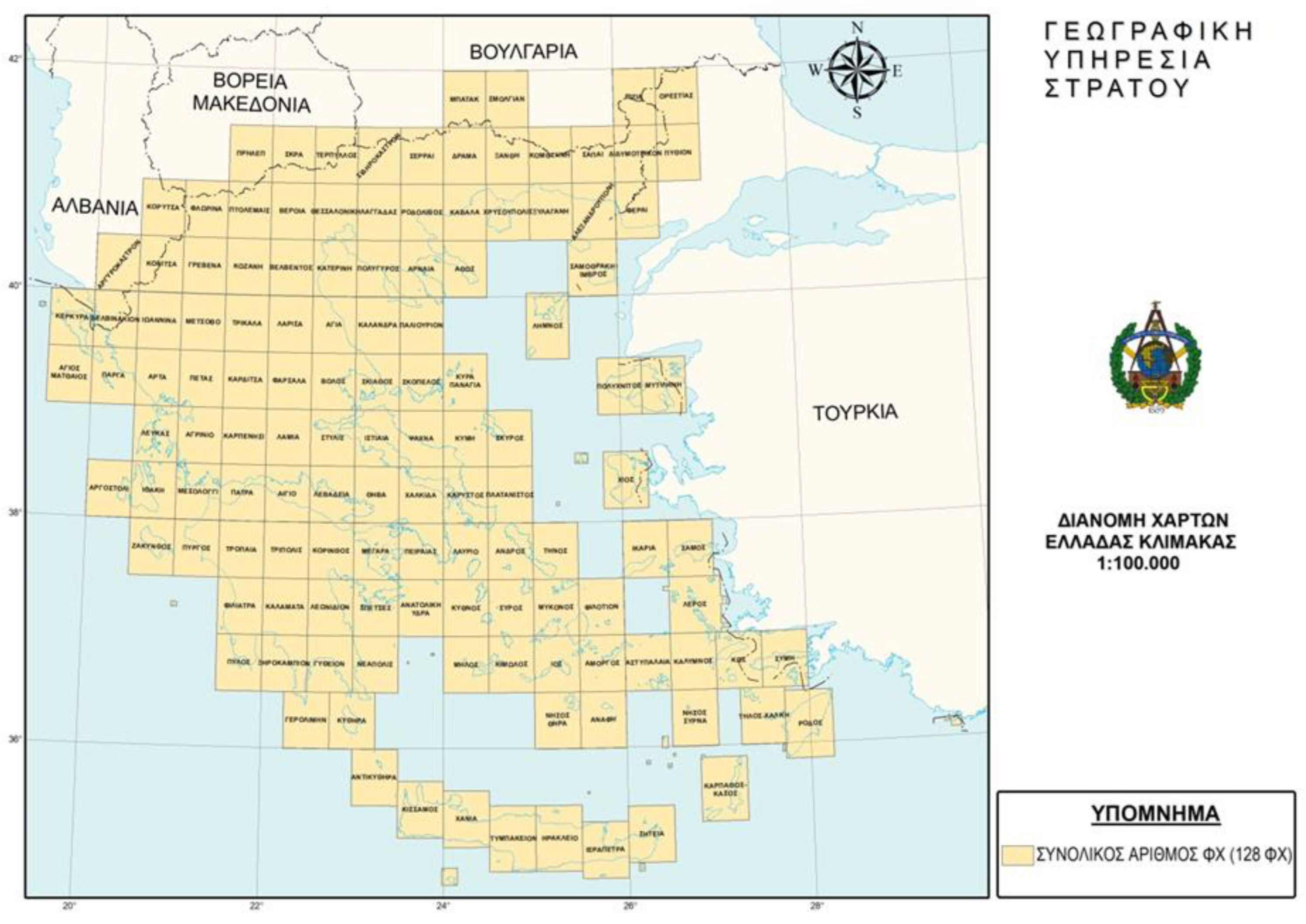
Figure 2.
Excerpt of a land distribution map, using OVGDR, (Source: Survey Agency of the Ministry of Agriculture).
Figure 2.
Excerpt of a land distribution map, using OVGDR, (Source: Survey Agency of the Ministry of Agriculture).
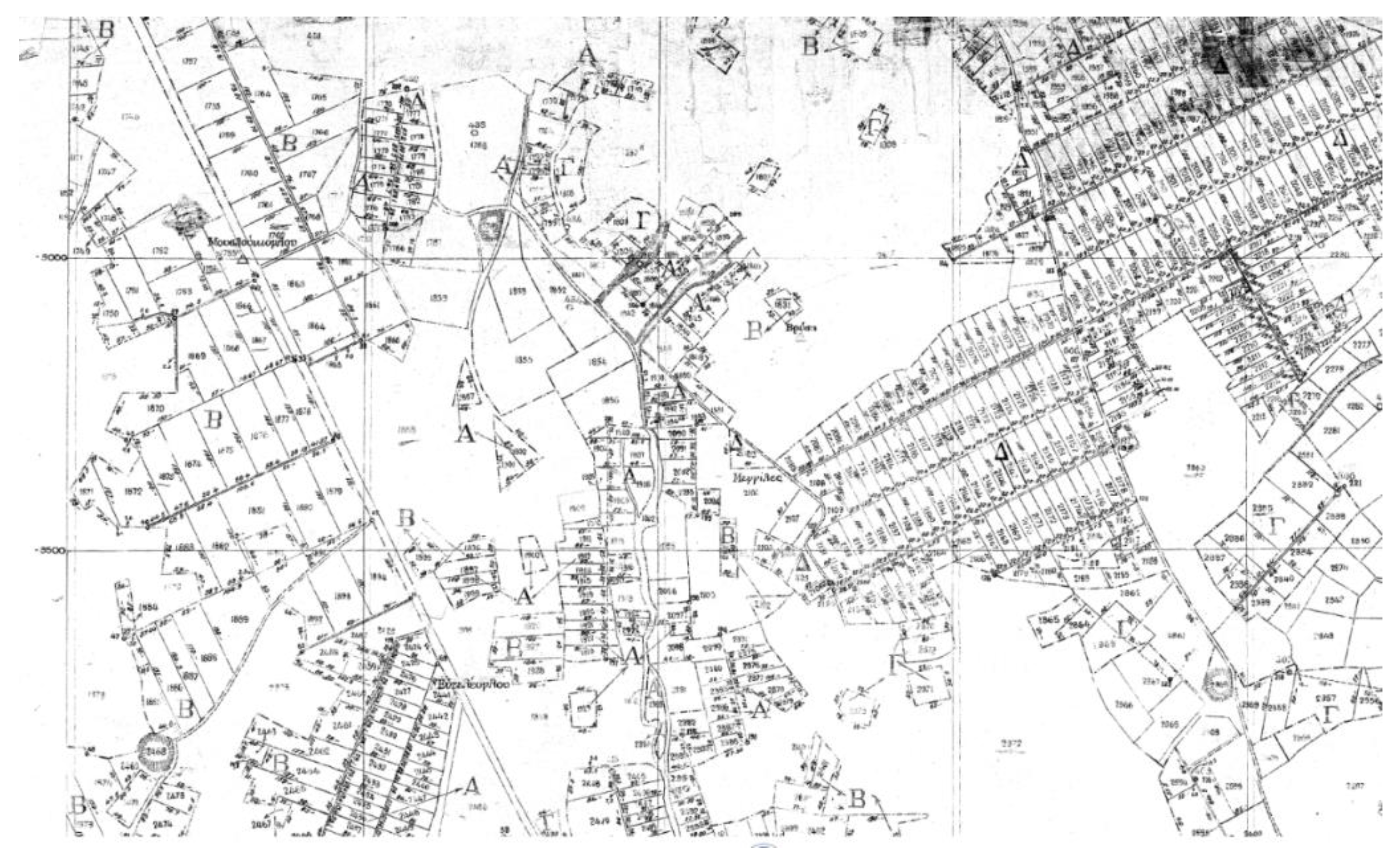
Figure 3.
The distance distortion factor of TM of GGRS87 [36].
Figure 3.
The distance distortion factor of TM of GGRS87 [36].
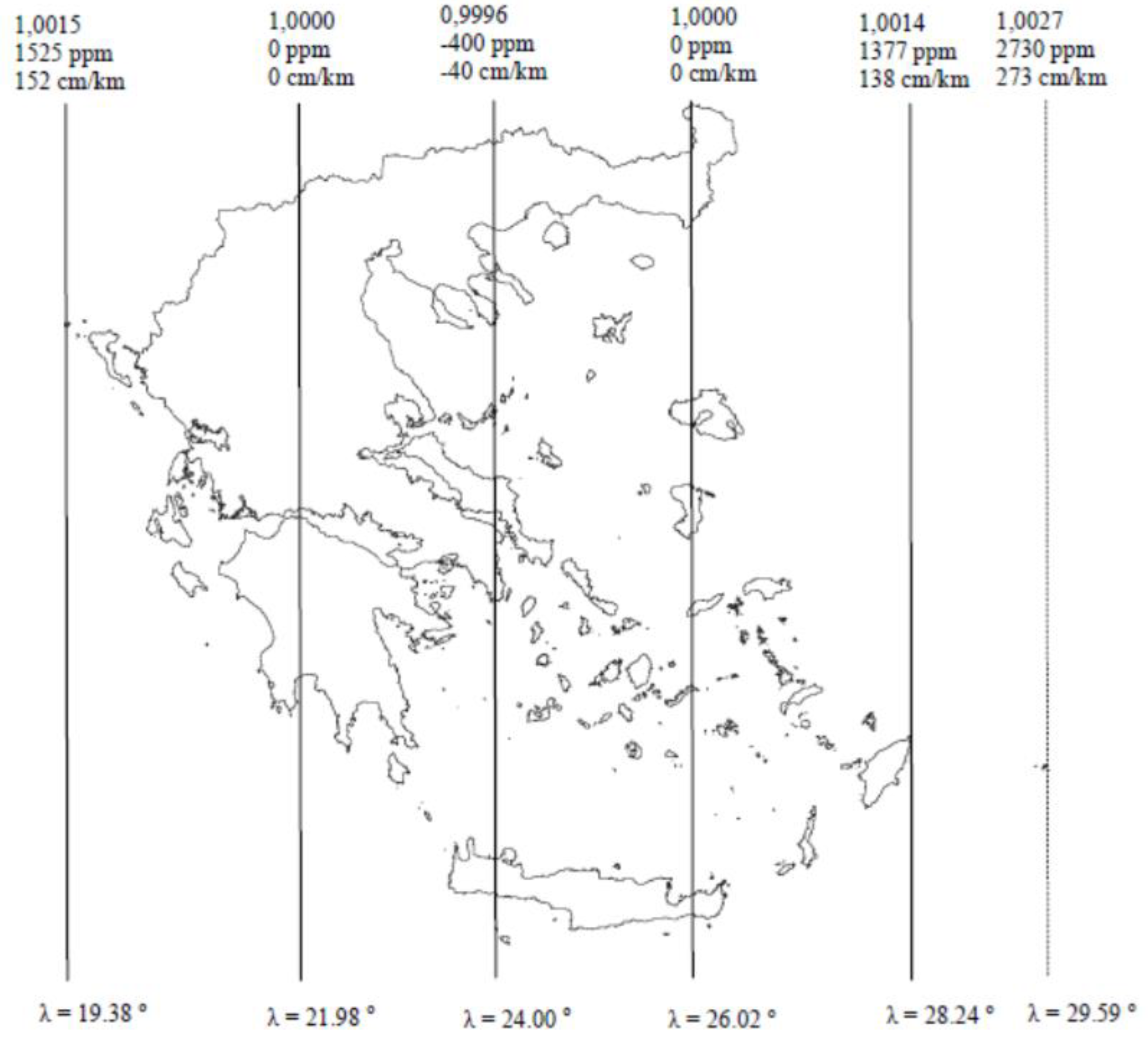
Figure 4.
The LADF estimation procedure.
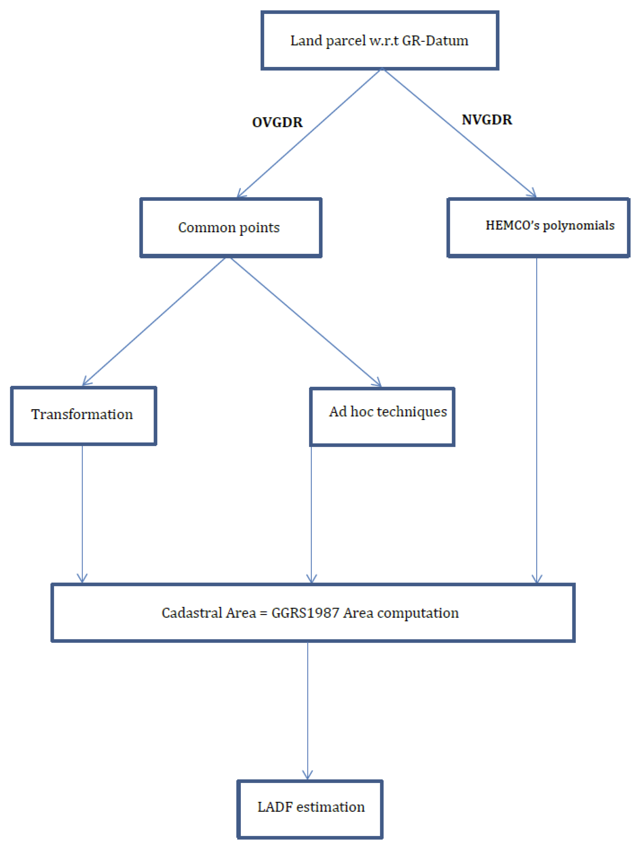
Figure 5.
Choristi Village greater area and current geodetic control points. Control points both in OVGDR and GGRS87 systems are denoted by yellow cross.
Figure 5.
Choristi Village greater area and current geodetic control points. Control points both in OVGDR and GGRS87 systems are denoted by yellow cross.
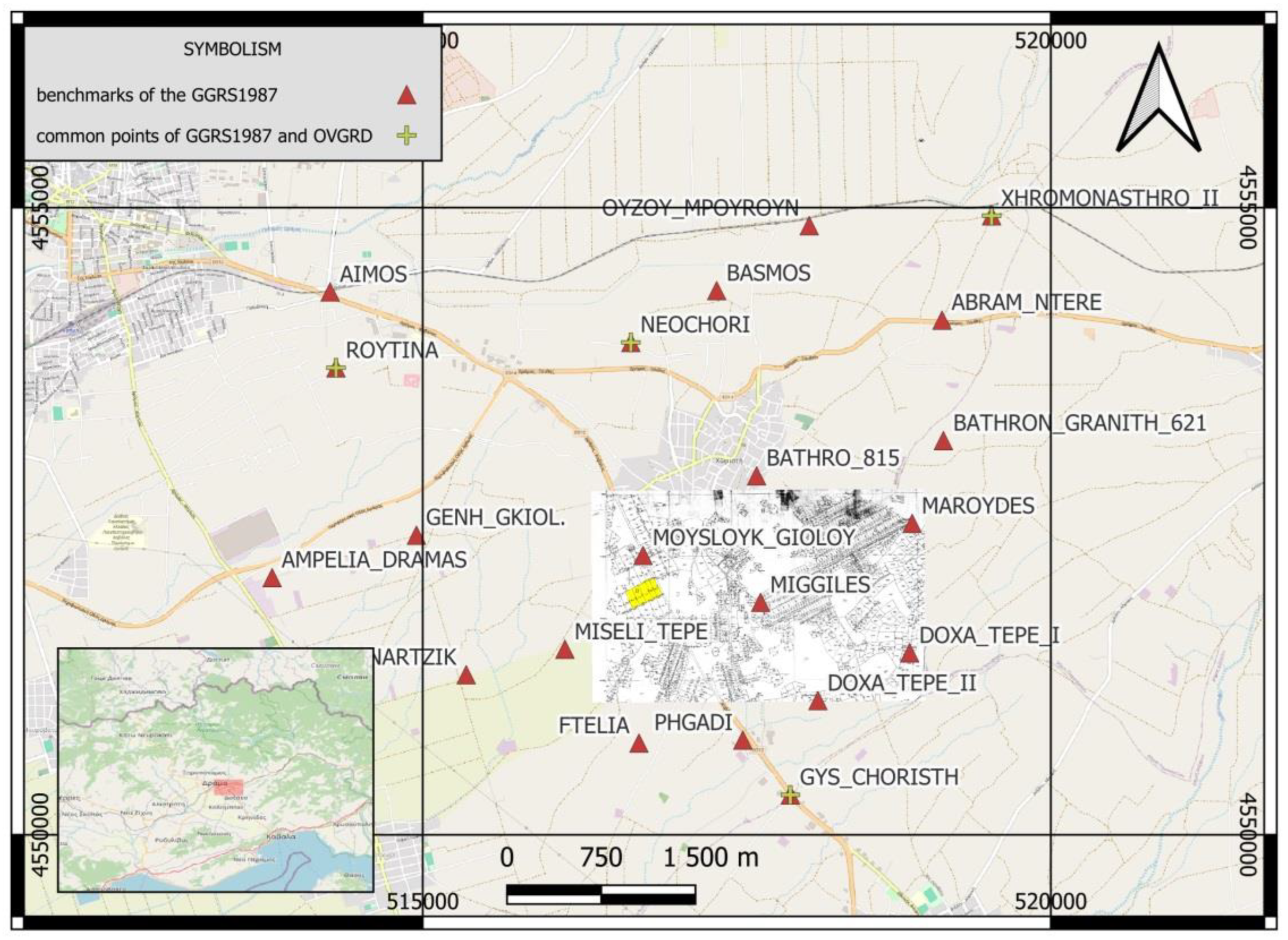
Figure 6.
Abstract from 1933 Choristi village SAMA land distribution and selected land parcels (yellow hatched).
Figure 6.
Abstract from 1933 Choristi village SAMA land distribution and selected land parcels (yellow hatched).
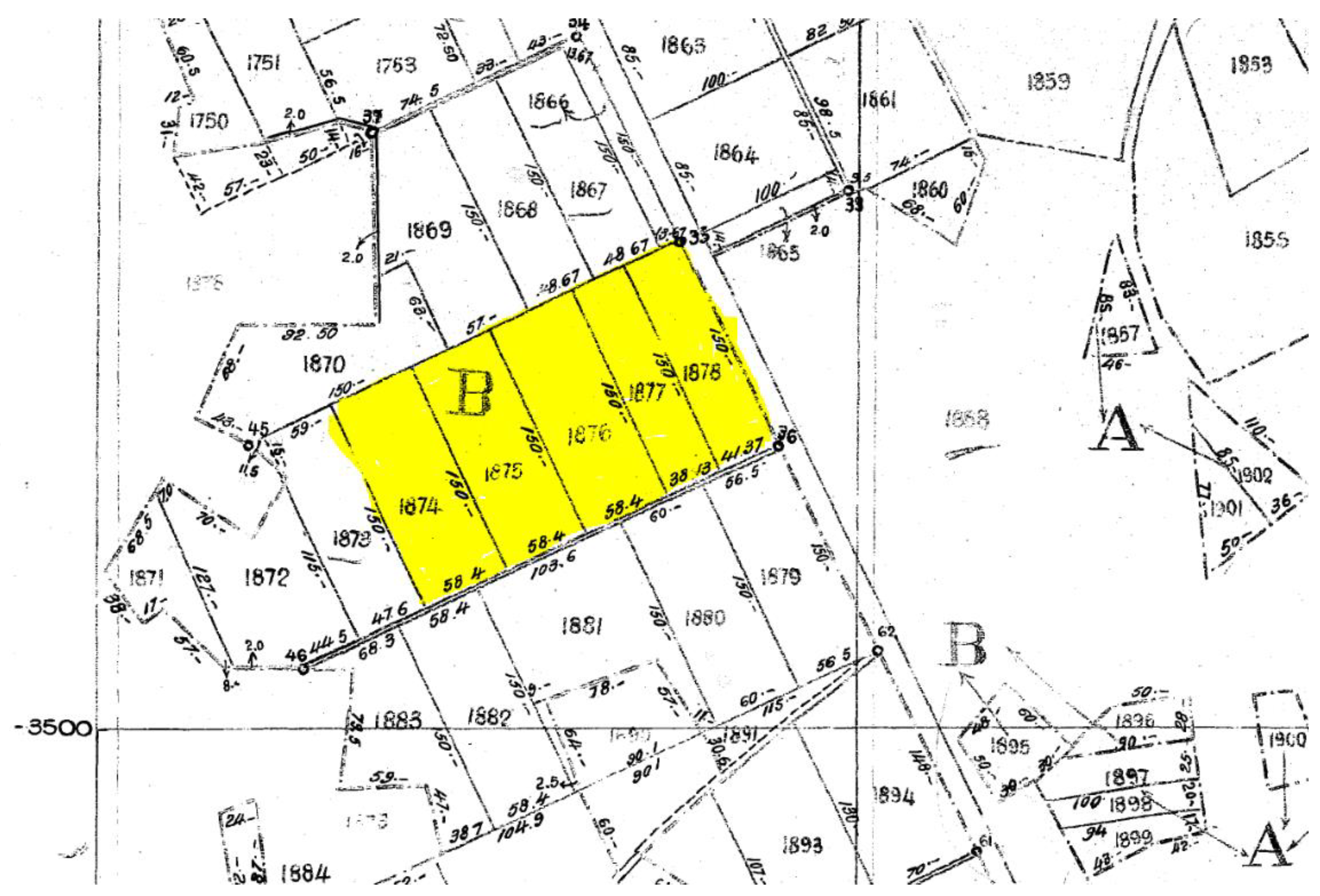
Figure 7.
Abstract from the current HC spatial DB of the study area.
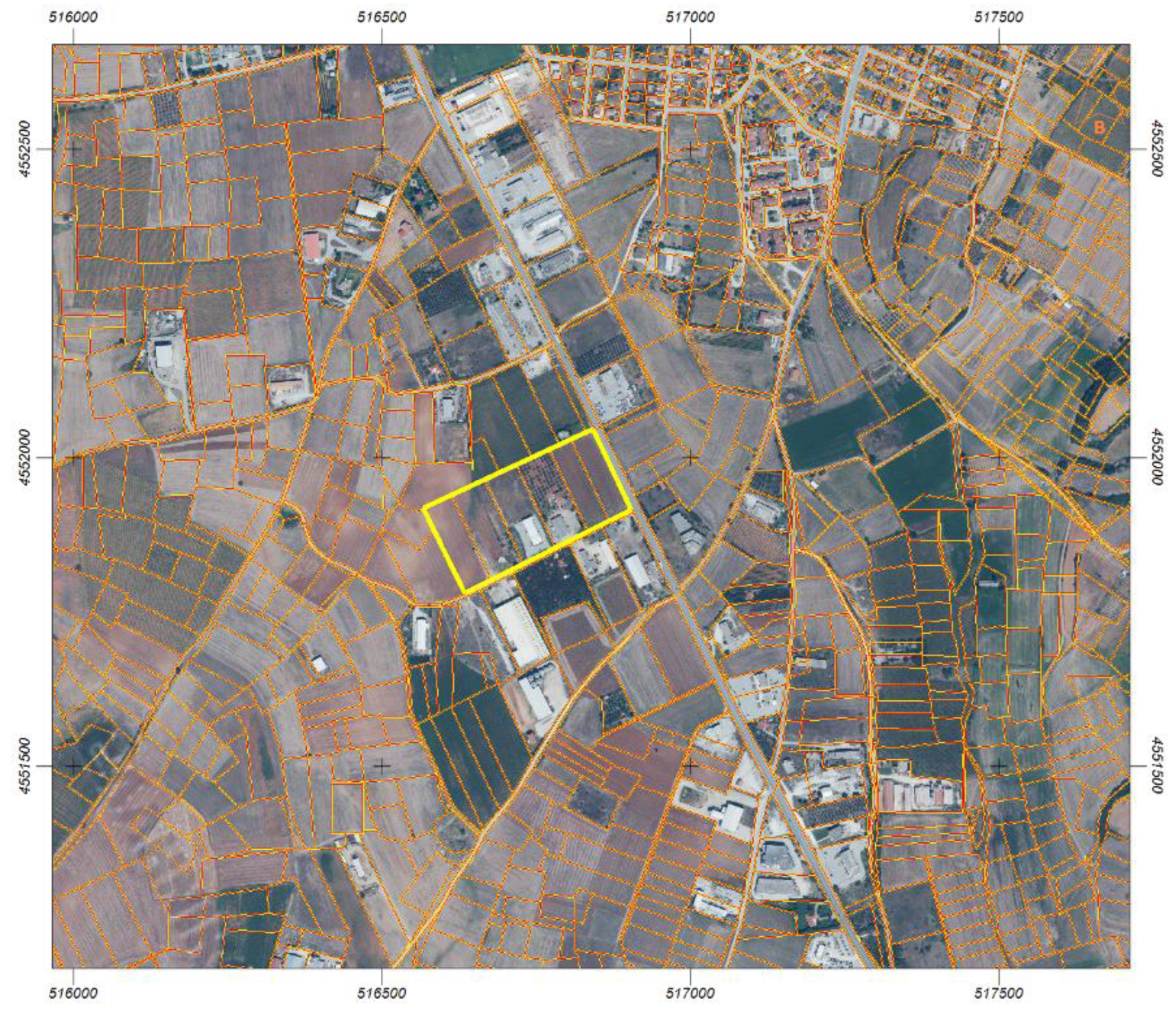
Figure 8.
HC boundaries and land parcels (blue color) and LADF boundaries and land parcels (red color).
Figure 8.
HC boundaries and land parcels (blue color) and LADF boundaries and land parcels (red color).
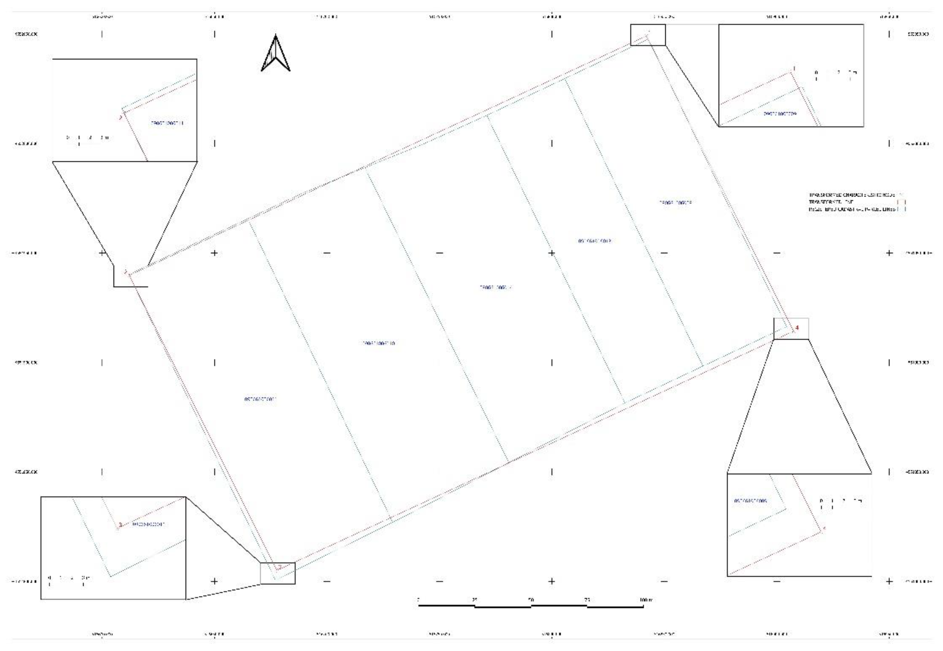

Table 1.
Results of the similarity transformation (eq. 2, ibid) from OVGDR to GGRS87.
| μ | 0.9992294 |
| θ (deg) | -0.1082833 |
| tx (m) | 516298.295 |
| ty (m) | 4552656.187 |
Table 2.
SAMA’s 1933 Choristi village distribution selected land parcels and their cadastral record.
Table 2.
SAMA’s 1933 Choristi village distribution selected land parcels and their cadastral record.
| Parcel number | KAEK | Ownership title area SAMA distribution (m2) | Cadastral area HC records (m2) |
Deviation (m2) | Deviation (m2) |
| 1874 | 050661006011 | 8,760 | 8990.62 | 230.62 | 2.41% |
| 1875 | 050661006010 | 8,760 | 8736.62 | -23.38 | -0.42% |
| 1876 | 050661006014 | 8,760 | 8624.50 | -135.50 | -1.73% |
| 1877 | 050661006013 | 5,720 | 5586.28 | -133.72 | -2.55% |
| 1878 | 050661006009 | 6,200 | 5998.04 | -201.96 | -3.53% |
Table 3.
SAMA’s 1933 Choristi village distribution selected land parcels cadastral record and LADF transformed calculated area.
Table 3.
SAMA’s 1933 Choristi village distribution selected land parcels cadastral record and LADF transformed calculated area.
| Parcel number | KAEK | Cadastral area HC records (m2) |
LADF transformed and calculated (m2) | Deviation (m2) | Deviation (m2) |
| 1874 | 050661006011 | 8990.62 | 8773.52 | 217.10 | 2.41% |
| 1875 | 050661006010 | 8736.62 | 8773.52 | -36.90 | -0.42% |
| 1876 | 050661006014 | 8624.50 | 8773.52 | -149.02 | -1.73% |
| 1877 | 050661006013 | 5586.28 | 5728.83 | -142.55 | -2.55% |
| 1878 | 050661006009 | 5998.04 | 6209.57 | -211.53 | -3.53% |
Disclaimer/Publisher’s Note: The statements, opinions and data contained in all publications are solely those of the individual author(s) and contributor(s) and not of MDPI and/or the editor(s). MDPI and/or the editor(s) disclaim responsibility for any injury to people or property resulting from any ideas, methods, instructions or products referred to in the content. |
© 2025 by the authors. Licensee MDPI, Basel, Switzerland. This article is an open access article distributed under the terms and conditions of the Creative Commons Attribution (CC BY) license (http://creativecommons.org/licenses/by/4.0/).
Copyright: This open access article is published under a Creative Commons CC BY 4.0 license, which permit the free download, distribution, and reuse, provided that the author and preprint are cited in any reuse.


