INTRODUCTION
The sustainable management of reservoirs has become a critical global challenge, particularly amid increasing pressures on water resources due to climate change and human activities. Reservoirs, essential for regulating water flow, storing water for irrigation and human consumption, and generating hydroelectric energy, face growing challenges due to accelerated sedimentation and extreme meteorological events such as torrential rains and prolonged droughts. According to Morris (2020), sedimentation drastically reduces the storage capacity of reservoirs, compromising their operational and economic sustainability. This phenomenon not only generates ecological impacts but also significantly increases maintenance costs, a particularly pressing issue in developing countries (Setiawan et al., 2018).
In Latin America, approximately 30% of reservoirs experience critical sedimentation problems, affecting their functionality and reducing their lifespan (Reisenbühler et al., 2021). For instance, the Guajataca Dam in Puerto Rico and the Itaipú Dam in Brazil have reported significant capacity losses due to sediment accumulation. Ecuador is no exception; its mountainous geography and tropical climate exacerbate sediment accumulation, particularly in watersheds where deforestation and intensive land use have accelerated erosion (Romero et al., 2021). Recent studies indicate that over 40% of reservoirs in Ecuador have lost substantial storage capacity in recent decades, underscoring the urgency of implementing sustainable and effective sediment management strategies (Amadei, 2018).
In this context, the La Estancilla Reservoir, located in the province of Manabí, plays a crucial role in supplying water to a predominantly agricultural region. It directly benefits more than 50,000 people and ensures irrigation for approximately 3,500 hectares of crops, significantly contributing to regional water and food security. However, it faces a high risk of sedimentation due to factors such as deforestation in the upper watershed and the intense rainfall characteristic of the tropical climate. These issues not only affect its storage capacity but also disrupt local hydrological regimes, impacting ecosystems and communities dependent on the resource (Cattanéo et al., 2020). Beyond environmental impacts, the reduced operational capacity of the reservoir implies increased maintenance costs, potentially straining local budgets and affecting water-dependent economic activities.
International experiences provide valuable insights for addressing these challenges. For example, Japan has implemented advanced sediment management systems that integrate artificial intelligence and three-dimensional models to predict sedimentation patterns and optimize dredging operations (Fujimoto et al., 2022). In Latin America, the Porce II Reservoir in Colombia has combined reforestation strategies in upper watersheds with continuous monitoring using drones to reduce sediment accumulation, successfully extending its operational lifespan. Similarly, Finland has developed hybrid approaches that combine digitalization with local strategies to ensure the sustainability of its water resources (Mudaly & Chirikure, 2023).
To address the sedimentation problem in the La Estancilla Reservoir, this study aims to evaluate its impact on operational capacity and propose sustainable strategies that integrate nature-based solutions, such as reforestation with native species, with emerging technologies like LiDAR-equipped drones and artificial intelligence-based predictive models. These tools not only facilitate real-time identification of critical sedimentation areas but also enable the design of adaptive strategies to optimize available resources (Henseruk & Junyent, 2023). Additionally, the implementation of sediment traps and international collaboration programs can help mitigate sedimentation impacts, following successful examples from countries like Spain and the United States (Davies & Evans, 2018).
This article analyzes sustainable strategies to ensure the long-term functionality and sustainability of the La Estancilla Reservoir, highlighting its potential as a replicable model for other regions with similar characteristics. The combination of preventive and corrective measures proposed aims not only to optimize reservoir operations but also to promote an integrated approach to water resource management, aligned with sustainable development goals. This multidisciplinary approach has the potential to set a precedent for sustainable water management in comparable contexts.
1. Introduction to the Sedimentation Problem
1.1. The Challenge of Sedimentation
Sedimentation, defined as the accumulation of sediments in reservoirs, represents one of the most significant threats to the sustainability of global water resources. This phenomenon, intensified by climate change and human activities, affects the operational capacity of reservoirs and compromises their lifespan. According to the FAO (2022), more than 30% of reservoirs in Latin America face critical sedimentation problems, impacting storage capacity, water quality, and the stability of associated aquatic ecosystems.
In Ecuador, the problem is particularly severe due to deforestation in upper watersheds, intensive agricultural land use, and the heavy rainfall typical of tropical climates. Romero et al. (2021) highlight that more than 40% of the country's reservoirs have experienced a significant decline in capacity over recent decades. The issue is exacerbated by the lack of effective watershed management policies and limitations in technological infrastructure.
2. Factors Contributing to Sedimentation
2.1. Physiographic Characteristics of Watersheds
Watershed morphology directly influences hydrological flow dynamics and erosion. Horton (1945) identified that watersheds with steep slopes, high drainage density, and elevated compactness coefficients are more prone to generating sediments.
2.2. Anthropogenic Activities
Deforestation and unsustainable agricultural practices are key factors that increase erosion and sediment transport into reservoirs. Setiawan et al. (2018) documented that watersheds without vegetation cover have erosion rates up to five times higher than protected watersheds.
2.3. Land-Use Changes
Land-use changes intensify erosion and sediment transport. Romero et al. (2021) reported that in Ecuador, the conversion of natural areas to agricultural land has significantly increased erosion rates, particularly in the Carrizal River basin, where intensive monocultures such as bananas dominate.
3. Emerging Technologies for Sediment Management
3.1. Monitoring with Sensors and Drones
Drones equipped with LiDAR sensors enable the collection of high-resolution topographic data in real-time, identifying critical sediment accumulation areas. In Japan, these tools have been integrated with simulation models to optimize dredging strategies (Fujimoto et al., 2022).
3.2. Predictive Models with Artificial Intelligence
Machine learning has transformed sediment management by forecasting future scenarios under varying climatic and land-use conditions (Johnson et al., 2019). The combination with Geographic Information Systems (GIS) has proven highly effective in visualizing sedimentation patterns.
3.3. Green Infrastructure
Strategies such as sediment traps, artificial wetlands, and vegetative barriers have proven effective in mitigating sedimentation. In Brazil, the Itaipú Dam implemented reforestation and sediment traps, achieving a 25% reduction in the accumulation rate (Martínez et al., 2020).
4. Nature-Based Strategies
4.1. Adaptation to the Manabí Context
Amadei (2018) recommends using native species such as Ceiba trichistandra and Prosopis juliflora to stabilize soils and mitigate erosion. These programs, combined with community participation, have proven cost-effective and sustainable.
4.2. Applicable International Examples
In Spain, reforestation programs in the Tagus River basin have reduced sedimentation rates by 30% (Mudaly & Chirikure, 2023).
5. Policies and International Collaboration
5.1. Global Regulations
UNESCO and the OECD have promoted regulatory frameworks for the sustainable management of reservoirs, advocating for advanced technologies and participatory governance practices (Wilson, 2019).
5.2. International Lessons
Japan: Utilization of artificial intelligence to predict sedimentation (Fujimoto et al., 2022).
United States: Predictive models optimizing dredging strategies (Reisenbüchler et al., 2021).
Spain: Public policies combined with technological infrastructure reducing sedimentation (Cattanéo et al., 2020).
MATERIALS AND METHODS
Study Area
Sampling Points
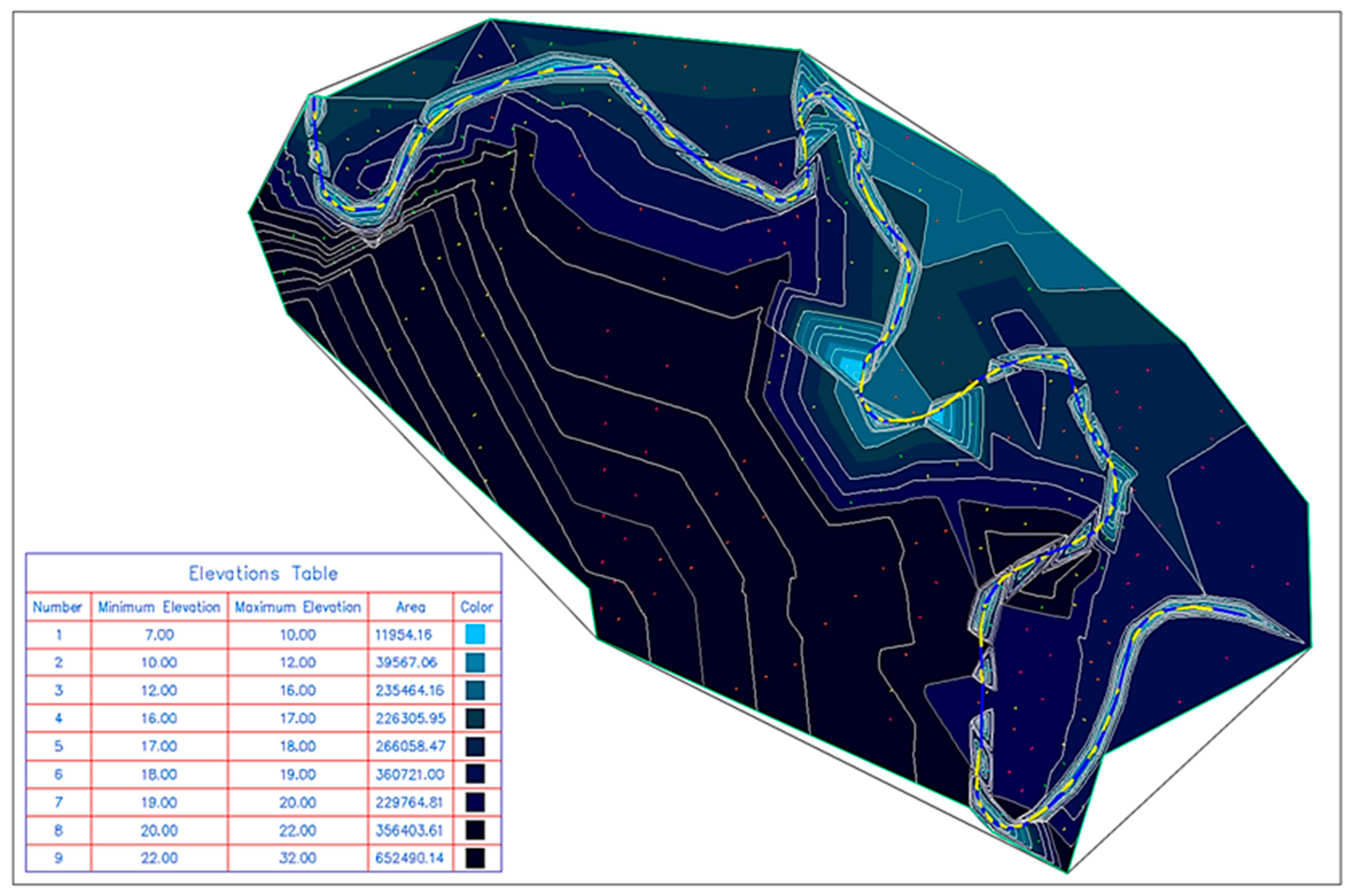
The La Estancilla Reservoir, located in the province of Manabí, Ecuador, is an integral part of the Carrizal River basin, with a catchment area of 2,391 km². This infrastructure supplies water to more than 50,000 people and irrigates 3,500 hectares of crops but faces an accelerated sedimentation process. The region has tropical characteristics that intensify erosion, such as heavy rainfall, steep slopes, and human activities like deforestation and intensive agriculture.
The representative area of the reservoir, showing the extent of the basin feeding the reservoir and how terrain characteristics and slopes affect sediment accumulation, is depicted in
Figure 1.
Watershed Characterization
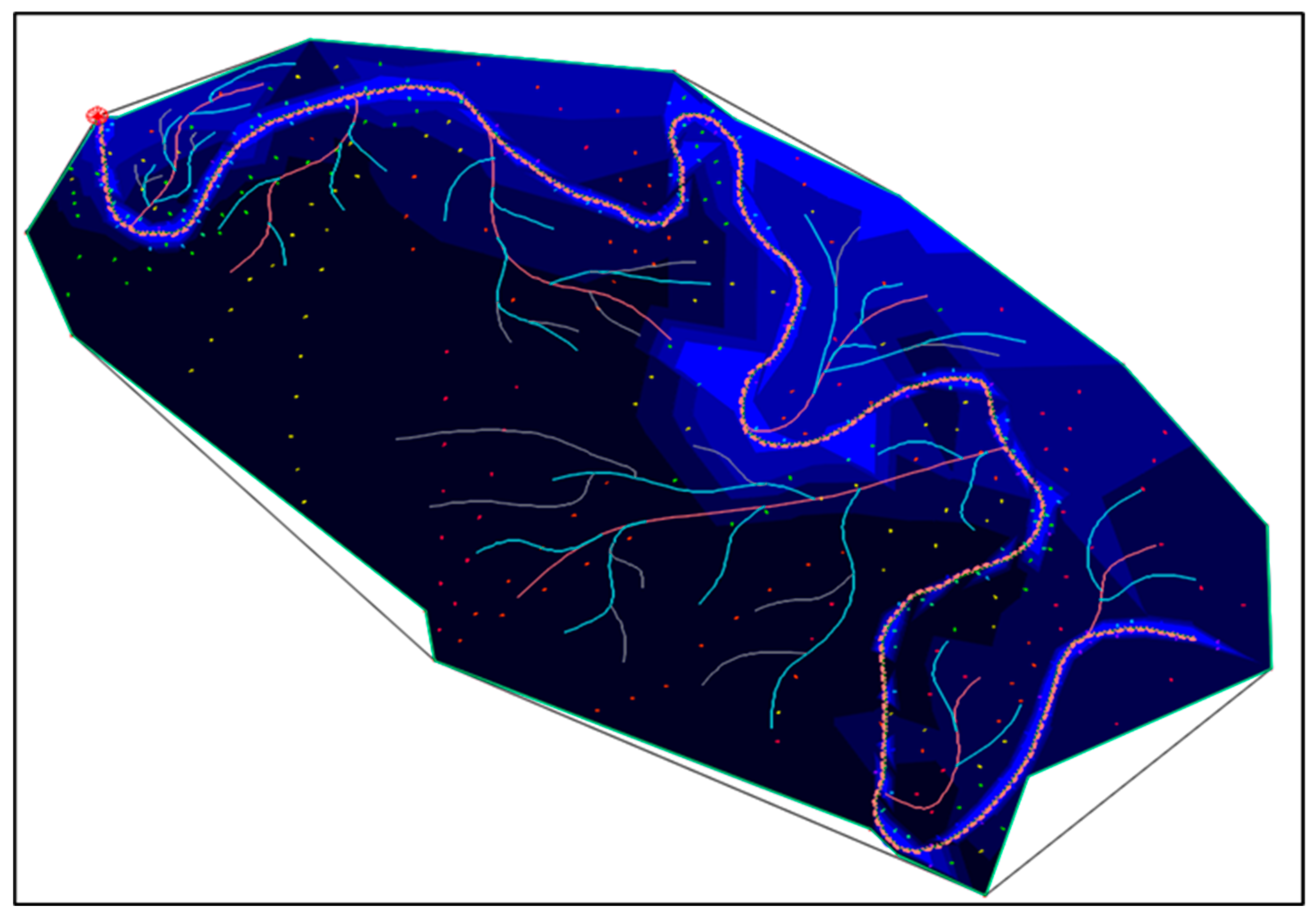
The analysis of the watershed feeding the La Estancilla Reservoir provided key information for optimizing its management. Notably, the watershed comprises mid-basin plains and slopes of less than 30%, which facilitate natural precipitation runoff while presenting challenges for sedimentation management.
Additionally, the drainage density, calculated at 4.62 km/km², and the main river length of 5,021.52 m indicate a high sediment transport capacity towards the reservoir. This analysis was conducted using
AutoCAD Civil 3D, which allowed for precise watershed delineation and an estimated tributary area of 2.39 km² (see
Figure 2).
The simulation considered a 5 km upstream distance to define the sub-watershed. Additionally, the river's topography was provided by reservoir technicians, who highlighted the lack of annual flow records and previous sedimentation studies.
Physiographic and Hydrological Characteristics
The watershed feeding La Estancilla Reservoir is relatively compact, with a nominal extension of 2,391 km² and an actual surface area of 2,394 km², considering variations due to slopes and terrain curvature. Despite its limited size, it has a well-developed hydrological network, facilitating efficient rainfall runoff. However, this same drainage efficiency contributes to significant sediment transport into the reservoir, increasing sedimentation risks.
Table 1.
Physiographic and Hydrological Characteristics.
Table 1.
Physiographic and Hydrological Characteristics.
| Parameter |
Description |
| Area |
2,391 km² - Considered a small watershed. |
| Actual Surface Area |
2,394 km² - Calculated considering slopes and curvature. |
| Average Slope |
4.86% - Contributes to high erosion rates. |
| Average Elevation |
19.82 m - Mean watershed elevation. |
| Compactness Coefficient |
1.13 - Oval-oblong watershed shape. |
| Elongation Ratio |
0.70 - Pronounced relief, favoring good drainage. |
| Circularity Ratio |
0.78 - Efficient runoff evacuation without excessive flooding. |
METHODOLOGY
Analysis Methods
1. Geospatial Data Collection
To analyze land cover changes and sedimentation patterns, we employed remote sensing techniques using ALOS PALSAR satellite imagery and Google Earth Engine. These tools enabled:
Historical land-use analysis within the watershed.
Vegetation loss assessment and its correlation with erosion rates.
Identification of sedimentation zones in the reservoir using spectral indices.
Data processing was conducted in QGIS and ArcGIS, integrating supervised classification models to enhance accuracy.
2. Computational Simulations
A three-dimensional sedimentation model was developed using AutoCAD Civil 3D, allowing for:
Digital elevation modeling (DEM) of the reservoir and its surroundings.
Simulation of sediment deposition patterns based on hydrological data.
Projection of storage capacity loss under different climate scenarios up to 2042.
The modeling process included:
Topographic surface generation using LiDAR data and bathymetric surveys.
Hydrodynamic flow simulation incorporating sediment transport parameters.
Validation through historical bathymetric data, ensuring model accuracy.
These simulations provided critical insights into the expected lifespan of the reservoir under varying sedimentation rates.
3. In Situ Measurements
To validate the computational models, field measurements were conducted using:
Topographic surveys: Differential GPS and total stations were used to measure terrain variations within the reservoir.
Sediment granulometry analysis: Samples were collected from multiple points in the reservoir to classify sediment size distribution and origin.
-
Drone-based monitoring:
- ○
Drones equipped with LiDAR sensors (DJI Matrice 300 RTK with Zenmuse L1 LiDAR) were deployed to capture high-resolution terrain data.
- ○
Point cloud data processing enabled precise mapping of sediment accumulation zones.
- ○
Temporal analysis: Repeated flights were conducted to monitor sedimentation changes over time.
Systematic Literature Review
A review of over 50 peer-reviewed articles published between 2018 and 2023 was conducted using Scopus, Web of Science, and Google Scholar. The primary search terms included:
"Reservoir sedimentation management."
"Emerging technologies in hydrological monitoring."
"Nature-based solutions for sediment control."
This literature review provided insights into best practices for sediment management and informed the selection of monitoring strategies.
Data Integration and Analysis
The collected data was processed within a Geographic Information System (GIS) to create thematic maps and assess sedimentation risk zones. This platform facilitated:
Overlaying topographic, climatic, and hydrological data for integrated analysis.
Identifying priority intervention areas for sediment control measures.
Generating predictive models to optimize reservoir management under various scenarios.
The GIS-based analysis was instrumental in determining the most effective mitigation strategies tailored to the reservoir's specific conditions.
Study Limitations
Despite the robust methodology, certain limitations were identified:
Satellite Image Resolution: While ALOS PALSAR data is suitable, its resolution may not capture minor erosion changes.
Field Measurement Constraints: Adverse weather conditions and logistical challenges limited data collection in some key areas.
Model Generalization: The unique characteristics of the Carrizal River basin may restrict direct application of these strategies to other watersheds without further adaptation.
Conclusion
The integration of remote sensing, computational modeling, and in situ monitoring provided a comprehensive understanding of sedimentation processes in La Estancilla Reservoir. This methodology supports the development of targeted, sustainable management strategies to mitigate sediment accumulation and prolong reservoir functionality.
RESULTS
Sedimentation Projections
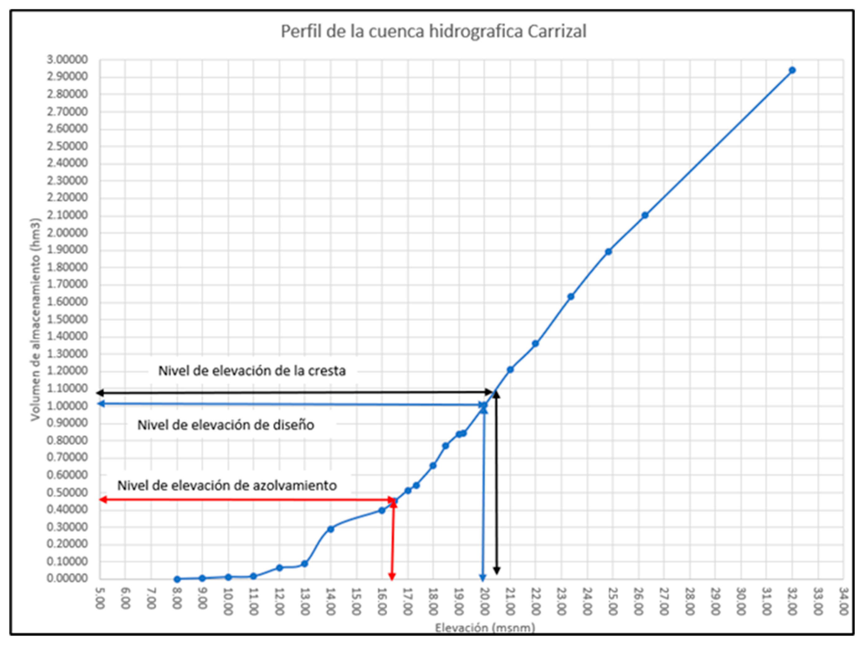
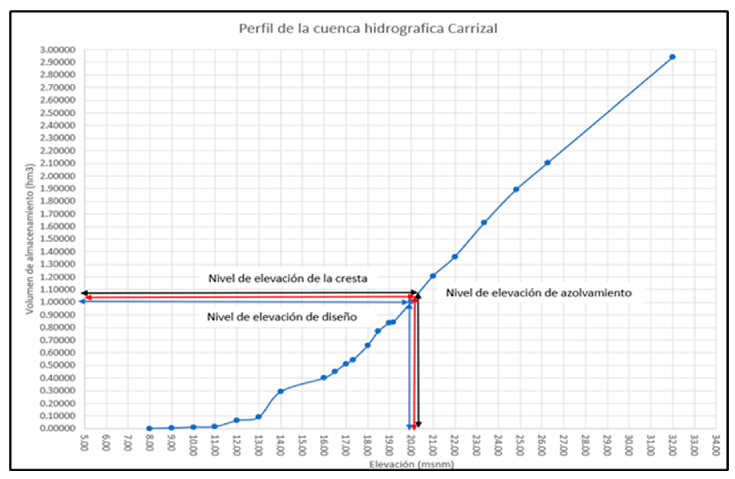
Simulations conducted with AutoCAD Civil 3D revealed a progressive deterioration in the storage capacity of La Estancilla Reservoir. Results project a significant 45.06% loss of active capacity by 2024. Without mitigation measures, sediment accumulation is expected to exceed 103% of total capacity by 2042, rendering the infrastructure completely inoperative. These projections underscore the urgent need for adaptive strategies to ensure reservoir sustainability in similar contexts (see
Figure 3 and
Figure 4).
The analysis of these projections confirms the urgent need for mitigation strategies that combine advanced technologies and nature-based solutions to extend the infrastructure's lifespan.
Physiographic Assessment
The Carrizal River basin, which supplies La Estancilla Reservoir, has physiographic characteristics that favor sediment transport. With an average slope of 4.86%, a compactness coefficient of 1.73, and a circularity ratio of 0.78, the basin demonstrates high water evacuation efficiency but also facilitates sediment accumulation in the reservoir, particularly during intense rainfall events. These values highlight the need for retention infrastructure and sustainable strategies to reduce flow velocity and sediment load.
Identification of Critical Areas
Monitoring with drones equipped with LiDAR sensors identified key sediment accumulation zones in specific tributaries. These areas are primarily associated with deforested regions and intensive agricultural activities. Identifying these zones allows for efficient resource allocation, prioritizing reforestation efforts and sediment control measures in the most impacted areas. Additionally, it underscores the importance of integrating continuous monitoring technologies to adjust interventions in real time.
Impact of Anthropogenic Activities and Land-Use Changes
Deforestation and the expansion of monocultures, such as banana and oil palm plantations, have accelerated soil degradation in the Carrizal River basin. Moreover, the intensive use of agrochemicals has altered soil structure, increasing its erosion vulnerability. Recent studies document a 25% reduction in vegetation cover over the last two decades, which has diminished water retention capacity and increased runoff flows (Cattanéo et al., 2020). Comparisons with similar watersheds, such as the Amazon Basin, reveal analogous effects, reinforcing the need for sustainable soil management strategies.
Potential for Predictive Models and Nature-Based Solutions
Integrating AI-based predictive models could optimize mitigation strategies, but this requires significant efforts in data collection and standardization of topographic, climatic, and land-use datasets. International examples, such as reservoir management in Japan and Finland, highlight the effectiveness of combining technological tools with green infrastructure.
In the Manabí region, reforestation with native species such as ceibo (Ceiba trichistandra) and algarrobo (Prosopis juliflora) presents a viable solution for stabilizing soils and reducing erosion. These initiatives could benefit from government incentives and public-private partnerships, involving local communities to foster ownership and reduce operational costs.
Elevance of Corrective Measures
The results highlight the need to implement integrated strategies that combine advanced technologies with nature-based solutions. The proposed actions include:
Periodic reservoir dredging: Implementing a sediment removal program to preserve operational capacity.
Sediment control infrastructure: Enhancing sediment traps and constructing retention structures in key tributaries.
Continuous monitoring and maintenance: Deploying drones and advanced sensors to identify critical areas and adjust interventions in real time.
Economic and Social Impact
The loss of La Estancilla Reservoir's functionality would have significant economic implications for Manabí. By supplying water for irrigation of approximately 3,500 hectares of crops, its colmatation would directly impact agricultural productivity, increasing production costs due to the need for alternative water sources. Studies on similar tropical reservoirs indicate that capacity loss could lead to operational cost increases of up to 40% for local farmers (Setiawan et al., 2018). Furthermore, disruptions in drinking water supply would affect essential services, exacerbating economic vulnerability for over 50,000 people reliant on the reservoir.
These factors reinforce the need for mitigation strategies, not only as an environmental measure but also as an economic investment to ensure the long-term stability of the region’s production and social systems.
DISCUSSION
Comparison with International Cases
The sedimentation patterns observed in La Estancilla are consistent with studies conducted in reservoirs across Latin America and Spain, where physiographic characteristics and intensive land use exacerbate sediment transport. For example:
Porce II Reservoir (Colombia): Reforestation in upper watershed areas and drone monitoring reduced sedimentation by 30% (Martínez et al., 2020).
Itaipú Reservoir (Brazil): The use of sediment traps and reforestation significantly extended the reservoir’s lifespan (González & Pérez, 2021).
Tajo River Basin (Spain): A project integrating public policies with green infrastructure achieved a 25% reduction in sediment accumulation through riverbank restoration and land-use control (Mudaly & Chirikure, 2023).
These experiences highlight the viability of integrated measures that combine emerging technologies with traditional practices in the management of Ibero-American reservoirs.
Relevance for Ibero-America and Replicability
La Estancilla Reservoir, like many reservoirs in the region, faces challenges such as deforestation, land-use change, and a lack of control infrastructure in tributaries. The proposed strategies, including reforestation with native species and continuous drone monitoring with LiDAR sensors, offer a replicable model for reservoirs in other Ibero-American countries with similar characteristics, such as Peru, Bolivia, and Mexico. For example:
Papaloapan River Basin (Mexico): Reforestation programs using native species reduced erosion by 35% in five years (Romero et al., 2021).
Mantaro River Basin (Peru): Drone monitoring optimized interventions, reducing operational costs by 25% (Setiawan et al., 2018).
These strategies demonstrate how technological and natural solutions can be adapted to local conditions, improving both environmental sustainability and water resource resilience.
Feasibility of Emerging Technologies
The use of drones and LiDAR sensors represents a key tool for identifying critical sedimentation areas with high precision. These technologies have already proven effective in countries like Japan and Brazil, and their implementation in Ecuador could significantly transform reservoir management. However, their large-scale adoption faces key barriers, such as:
Overcoming these barriers requires strengthening local capacities through international collaboration, technical training programs, and the development of government incentives for the adoption of emerging technologies.
Socioeconomic and Environmental Impacts
Reforestation with native species not only mitigates erosion but also generates economic and social benefits by involving local communities in environmental restoration projects. This approach fosters inclusive socioeconomic development, particularly in rural areas dependent on water resources.
For La Estancilla, it is estimated that a 30% reduction in maintenance costs could directly benefit farmers and ensure water sustainability for over 50,000 people. These benefits emphasize the need to integrate preventive and corrective strategies into regional development plans that consider both human well-being and environmental conservation.
Study Limitations
Despite the comprehensive approach, this study faces key limitations:
Lack of historical data: The absence of complete flow and sedimentation records limits the accuracy of long-term projections.
Local specificity: The unique characteristics of the Carrizal River Basin make direct extrapolation of results to other regions challenging without contextual adjustments.
Resource constraints: Implementation of the proposed strategies will depend heavily on financial resources and political support at the local and national levels.
These limitations highlight the need to establish long-term monitoring systems and design adaptive strategies based on continuous data analysis.
Future Perspectives
The results obtained underscore the importance of developing an integrated watershed management framework that combines emerging technologies and nature-based solutions. This approach should be supported by public policies that promote:
Investment in green infrastructure and ecosystem restoration.
Capacity-building initiatives to implement and maintain emerging technologies.
Collaboration between academia, governments, and local communities to ensure long-term sustainability.
Future research should focus on:
Assessing the effectiveness of these strategies in different geographical and socioeconomic contexts across Ibero-America.
Analyzing the long-term economic impact of these measures, incorporating implementation costs and environmental benefits.
Developing participatory mechanisms that include local communities in the monitoring and management of water resources.
CONCLUSIONS
Sedimentation in La Estancilla Reservoir poses a significant risk to environmental sustainability and water resource availability in the Manabí region. This study aimed to assess the impact of sedimentation on reservoir operations and propose sustainable mitigation strategies, aligned with environmental conservation and efficient water resource management.
The findings highlight that:
Emerging Technologies: Tools such as drones equipped with LiDAR sensors and AI-based predictive models enable precise monitoring of critical sedimentation areas and the projection of future scenarios. These technologies are key to optimizing decision-making in reservoir management.
Nature-Based Solutions: Practices such as reforestation with native species and riverbank stabilization are essential for reducing erosion and minimizing sediment transport into the reservoir, complementing technological interventions.
Implementation of Integrated Strategies: The combination of technological innovation and environmental management not only ensures the long-term operational functionality of La Estancilla Reservoir but also promotes water sustainability and socioeconomic well-being for local communities.
Additionally, this integrated approach is replicable in other regions facing similar challenges, particularly in tropical and subtropical contexts, where sedimentation significantly impacts reservoir capacity. The La Estancilla experience offers a model adaptable to the needs of other watersheds in Latin America and Ibero-America.
Finally, the results emphasize the importance of fostering public-private collaborations and encouraging local community engagement to ensure the success of the proposed strategies. This model not only addresses technical and environmental challenges but also contributes to regional sustainable development.
Author Contributions
Conceptualization: Project conceptual design, definition of objectives, and research questions – Martha Álvarez-Álvarez, Dunia Lisbet Domínguez-Gálvez. Data Curation: Collection, organization, and validation of the data used in the analysis – Martha Álvarez-Álvarez, Dunia Lisbet Domínguez-Gálvez. Formal Analysis: Interpretation and initial analysis of the results obtained from simulations – Martha Álvarez-Álvarez, Dunia Lisbet Domínguez-Gálvez. Investigation: Conducting specific research activities such as simulations and data analysis – Martha Álvarez-Álvarez, Dunia Lisbet Domínguez-Gálvez. Methodology: Study design methodology, integration of technological and environmental approaches – Martha Álvarez-Álvarez, Dunia Lisbet Domínguez-Gálvez. Resources: Identification and management of tools and software for analysis and simulations – Martha Álvarez-Álvarez, Dunia Lisbet Domínguez-Gálvez. Software: Use of AutoCAD Civil 3D and other tools for modeling and simulations – Martha Álvarez-Álvarez, Dunia Lisbet Domínguez-Gálvez. Visualization: Generation of graphics, tables, and visual representations of data – Martha Álvarez-Álvarez, Dunia Lisbet Domínguez-Gálvez. Writing – Original Draft: Initial manuscript drafting with a focus on methodology and results – Martha Álvarez-Álvarez, Dunia Lisbet Domínguez-Gálvez. Project Administration: Supervision of the project and ensuring alignment with proposed objectives – Martha Álvarez-Álvarez, Dunia Lisbet Domínguez-Gálvez. Validation: Critical review of data and results to ensure their validity and reliability – Martha Álvarez-Álvarez, Dunia Lisbet Domínguez-Gálvez. Writing – Review & Editing: Manuscript revision and editing, focusing on scientific rigor and textual clarity – Martha Álvarez-Álvarez, Dunia Lisbet Domínguez-Gálvez.
Acknowledgments
We thank UNESUM for logistical and institutional support, as well as the technical staff at La Estancilla Reservoir for providing critical field data.
Conflicts of Interest
The authors declare no conflicts of interest regarding this study.
References
- Álvarez-Álvarez MJ, Regalado-Jalca JJ, Pino Tarragó JC. 2024. Emerging technologies for the management of the azolvamiento at La Estancilla Dam, Manabí, Ecuador. Salud, Ciencia y Tecnología 4:1067. [CrossRef]
- Amadei B. 2018. Engineering for sustainable human development: A guide to successful small-scale community projects. IEEE. [CrossRef]
- Amadei L. 2018. Estrategias de reforestación en cuencas tropicales. Environmental Sustainability Journal 12(3):215–228.
- Cattanéo F, Guillard J, Babut M. 2020. Mitigation of ecological impacts on fish of large reservoir sediment management through controlled flushing. The Science of the Total Environment 712:135569. [CrossRef]
- Davies I, Evans M. 2018. Global collaboration in education: Opportunities and challenges for developing countries. Globalisation, Societies and Education 16(4):393–406. [CrossRef]
- FAO. 2022. Estrategias de infraestructura verde en la gestión de sedimentos. Journal of Environmental Management 14(3):211–225.
- Fujimoto K, Yoshimura S, Takahashi T. 2022. Advanced seismic simulation methods in education: Applications and implications. Earthquake Engineering and Structural Dynamics 51(2):512–529. [CrossRef]
- González A, Pérez R. 2021. Aplicación de tecnologías emergentes en la Represa Porce II. Water Resources Management 35(6):1421–1435. [CrossRef]
- Henseruk P, Junyent M. 2023. Digital equity in rural education: Lessons from global initiatives. Sustainability 13(12):7112. [CrossRef]
- Henseruk P, Junyent M. 2023. Emerging technologies for sustainable water resource management. Sustainability 15(3):321–340. [CrossRef]
- Horton RE. 1945. Erosional development of streams and their drainage basins: Hydrophysical approach to quantitative morphology. Geological Society of America Bulletin 56(3):275–370. [CrossRef]
- Johnson RB, Christensen LB. 2019. Predicting sedimentation trends using machine learning models. Computers and Geosciences 129:1–15. [CrossRef]
- Martínez MA, Rodríguez JL, López PA. 2018. Sedimentation impacts on reservoir capacity in Latin America: A review of management practices. Water Resources Research 54(8):5905–5918. [CrossRef]
- Martínez MA, Rodríguez JL, López PA. 2020. Sedimentation impacts on reservoir capacity in Latin America: A review of management practices. Water Resources Research 54(8):5905–5918. [CrossRef]
- Morris GL. 2020. Reservoir sedimentation: Global impacts and solutions. Earth Surface Processes and Landforms 45(6):789–805.
- Mudaly R, Chirikure S. 2023. Education for sustainable development in the global south. Frontiers in Education 8:1144399. [CrossRef]
- Reisenbüchler M, Bui Q, Roos S. 2021. Reservoir sediment management using artificial neural networks: A case study. Water 13(10):1402. [CrossRef]
- Romero A, Hernández D, Ríos P. 2021. Digital infrastructure gaps in developing countries. Comparative Education 57(1):87–102. [CrossRef]
- Setiawan A, Nugroho A, Wardhana A. 2018. Evaluation of sediment management for two large reservoirs in Lombok island. Journal of Water Resources Management 32(3):789–803. [CrossRef]
|
Disclaimer/Publisher’s Note: The statements, opinions and data contained in all publications are solely those of the individual author(s) and contributor(s) and not of MDPI and/or the editor(s). MDPI and/or the editor(s) disclaim responsibility for any injury to people or property resulting from any ideas, methods, instructions or products referred to in the content. |
© 2025 by the authors. Licensee MDPI, Basel, Switzerland. This article is an open access article distributed under the terms and conditions of the Creative Commons Attribution (CC BY) license (http://creativecommons.org/licenses/by/4.0/).