Submitted:
10 February 2025
Posted:
11 February 2025
You are already at the latest version
Abstract
This study investigates the spatial relationship patterns centered around ancestral halls in villages in Jimei, China. Using a "reverse geomancy " approach, the study records the polar coordinates and orientations of 45 ancestral halls and their surrounding key elements such as feng-shui ponds, groves, drama stages, etc. to analyze the spatial distribution patterns of critical elements within the villages. The findings reveal verifiable spatial patterns in Jimei villages, some patterns such as the orientation of ancestral halls and the placement of feng-shui ponds, are related to traditional geomancy principles, while others are influenced by social needs and the built environment. Through statistical analysis across time, the study uncovers the historical logic of village construction and the ways feng shui principles have been integrated in Jimei. It emphasizes the importance of preserving the overall spatial patterns of villages, offers protection recommendations for elements like ponds and groves, and highlights the broad applicability of the research method to other settlement studies.
Keywords:
Village studies
; Spatial patterns
; Polar coordinate analysis
; Southern Fujian villages
; Ancestral halls
1. Introduction
The preservation and development of rural architectural environment have been a topic of interest worldwide. Villages within a cultural region often exhibit specific spatial patterns. For instance, Chinese villages typically feature ancestral halls, ponds, plazas, and large trees, with these elements arranged to satisfy certain spatial relationships. Systematically summarizing these spatial relationships in villages and extracting spatial patterns not only serves as a crucial foundation for localized preservation but also provides a key pathway for promoting the inheritance and development of regional architectural culture in modern construction projects. Through scientific spatial cognition, we can systematically document and analyze the spatial layout, building locations, and their evolution within villages, which aids in formulating scientific development plans and guiding the maintenance and restoration of villages.
Ancestral hall plays an irreplaceable central role in summarizing the spatial patterns of villages in China[1], particularly in the Minnan (southern Fujian)[2,3]. The southern Fujian is a culturally diverse area, encompassing three UNESCO World Heritage Sites (Fujian Tulou, Kulangsu, and Quanzhou) within its 25,324 square kilometers (Figure 1). Despite its cultural diversity, the dominant ethnic group in southern Fujian is the Han, who have preserved the tradition of ancestor worship, leading to the construction of "ancestral hall" buildings in villages. These can be categorized into two types: clan ancestral halls and family ancestral halls. Clan ancestral halls serve as the center for larger kinship groups maintained through relatively loose clan-based bloodline connections[4], while family ancestral halls act as the nucleus for smaller kinship branches organized in a cluster-like distribution based on closer bloodline ties. The specific patterns of kinship distribution[5] have been confirmed by previous studies and are not the focus of this research. Many suburban areas in Fujian face demolition, with the removal of ancestral halls and temples becoming a significant challenge[6].
Some studies have noted the central role of ancestral halls but have not focused on other key elements of the village, instead concentrating on the relationship between ancestral halls and other residential buildings[1]. This study focuses on the spatial pattern relationships between ancestral halls and other key village elements such as ponds, trees, and drama stages. Many ancestral halls were come from Zu Cuo(祖厝), usually the first houses built in the village by the ancestors. Although these structures have undergone repairs, reconstructions, and demolitions over time, their locations and orientations have often remained unchanged. Other ancestral halls were constructed shortly after the village began to prosper, with their sites chosen by feng-shui masters at the request of the clan members.
From the perspective of village spatial organization, the siting of ancestral halls—given their historical significance—reflects the ancestors’ spatial understanding of the area, while changes in their surrounding environment illustrate the spatial adaptations made by successive generations of villagers during the village’s development. Moreover, under the strong influence of clan culture in the southern Fujian region, these ancestral halls play a significant role in shaping the spatial order and patterns of the entire village[7]. Therefore, ancestral halls serve as a central object of study for understanding the spatial patterns of southern Fujian villages.
In previous studies on village spatial patterns, researchers often refer to observation and summarization methods, relying on personal judgment to manually identify village patterns. While this approach is often effective, it is inevitably subjective, and the process of drawing conclusions is difficult to replicate across different observers. Systematic research should be based on objective data rather than subjective perceptions. Such work typically involves detailed documentation of specific spatial information within villages, followed by the use of statistical tools to derive conclusions about spatial patterns. In southern Fujian villages, is there a statistically verifiable spatial relationship pattern centered around ancestral hall architecture? What methods should be used to study this, and what conclusions can be drawn? These are the questions this study seeks to address.
2. Research Subjects and Methods
2.1. Research Subjects
Jimei is located in Xiamen City, Fujian Province, China, an area that had a large number of villages and is renowned as a hometown for overseas Chinese[8], particularly those with roots in Southeast Asia. Although the southern Fujian region is mountainous, numerous villages are distributed across coastal plains and intermountain basins. These villages can be categorized by their architectural forms into three types: ancient villages with entirely traditional buildings, mixed villages with both old and new buildings, and newly constructed villages with entirely modern buildings[9]. Due to Xiamen's rapid economic development since the opening-up period, the construction of new buildings is widespread, and purely ancient villages are nonexistent in Jimei. Newly constructed villages lack the traditional kinship ties that underpin the existence of ancestral halls. Therefore, this study focuses on high-density mixed villages in the Jimei area, where the proportion of new buildings is higher than that of old ones.
Within the administrative boundaries of Jimei District, the study focuses on a specific geographic area located north of the Houxi-Xuxi water system, west of the coastline, and surrounded by mountains. This area roughly falls under the jurisdiction of Jimei Subdistrict, Qiaoying Subdistrict, and Houxi Town. Additionally, the study includes Houtian Village (a coastal village near Jimei but under Tong'an District) and Dingxu Village (a village near the upper reaches of the Xuxi River, under Guankou Town). In total, the study covers 35 villages.
Through map-based analysis and on-site field investigations, the study identified 45 ancestral halls within the Jimei District area. These ancestral halls are distributed across 28 of the 35 villages within the research scope. The remaining 7 villages were excluded from the study due to the absence of ancestral halls or other objective reasons. The research area and the geographic locations of the 45 ancestral halls are shown in the map (Figure 2 and Figure 3). It is evident that the majority of these ancestral halls are situated in low-lying areas with an elevation of less than 15 meters.
2.2. The methodology of Reverse Geomancy
This section discusses the methodology of the study and the relationship between Geomancy and the research approach.
The study focuses on the planar spatial relationships between various key elements in the village and the ancestral halls. This requires recording the spatial coordinates of these elements relative to the ancestral halls. If the ancestral hall is taken as the origin of the coordinate system, the positions of these elements can be represented by the differences in their latitude and longitude values relative to the ancestral hall (ΔX, ΔY) and plotted on a Cartesian coordinate system.
However, preliminary field investigations revealed that most ancestral halls are not oriented strictly along the north-south axis (be discussed later). In fact, their orientations vary widely. Under such circumstances, the two numerical values in a Cartesian coordinate system lack clear practical significance for interpreting spatial relationships. Instead, the polar coordinate system, traditionally used in Chinese geomancy, is more suitable for this study. By recording the distance and angle of target points relative to the origin (R, θ), the polar coordinate system aligns better with the needs of this research[10].
The theory of Geomancy, broadly referring to the theoretical system of Feng Shui(风水), is a discipline within traditional Chinese culture that primarily studies the relationship between humans and their natural environment. The term Geomancy called "Kan Yu(堪舆)", originates from the I Ching, where "Kan" refers to the way of heaven, and "Yu" refers to the way of earth, together symbolizing the principles of heaven and earth. Feng Shui incorporates certain scientific principles, some of which have been validated by modern science[11,12]. However, its mystical elements are often regarded as superstitious. As a whole, this discipline is not considered a scientific method within the Chinese architectural field. Nevertheless, the tool it employs, the "luopan" (geomancy compass), is a rational surveying instrument that embodies traditional Chinese wisdom.
Luopan is a precision instrument composed of a central compass needle for determining direction and an outer copper plate marked with multiple layers of scales, which is further encased in wood. The modern luopan in the author’s possession replaces the wooden casing with Bakelite and is equipped with a leveling tool and crosshairs. A more advanced luopan may include features such as laser alignment, rangefinders, and even GPS. The focus of research lies in the scale divisions on the luopan. The luopan is divided into eight major scales, corresponding to the eight trigrams (Bagua), with each trigram further divided into three "Shan" making a total of 24 Shan. Each Shan corresponds to 15°, such as the south aligning with the Wu Shan and the north with the Zi Shan. This study adopts the 24 Shan angular method to replicate the ancient geomantic methods of the past.
Figure 4.
Shan and author’s luopan.
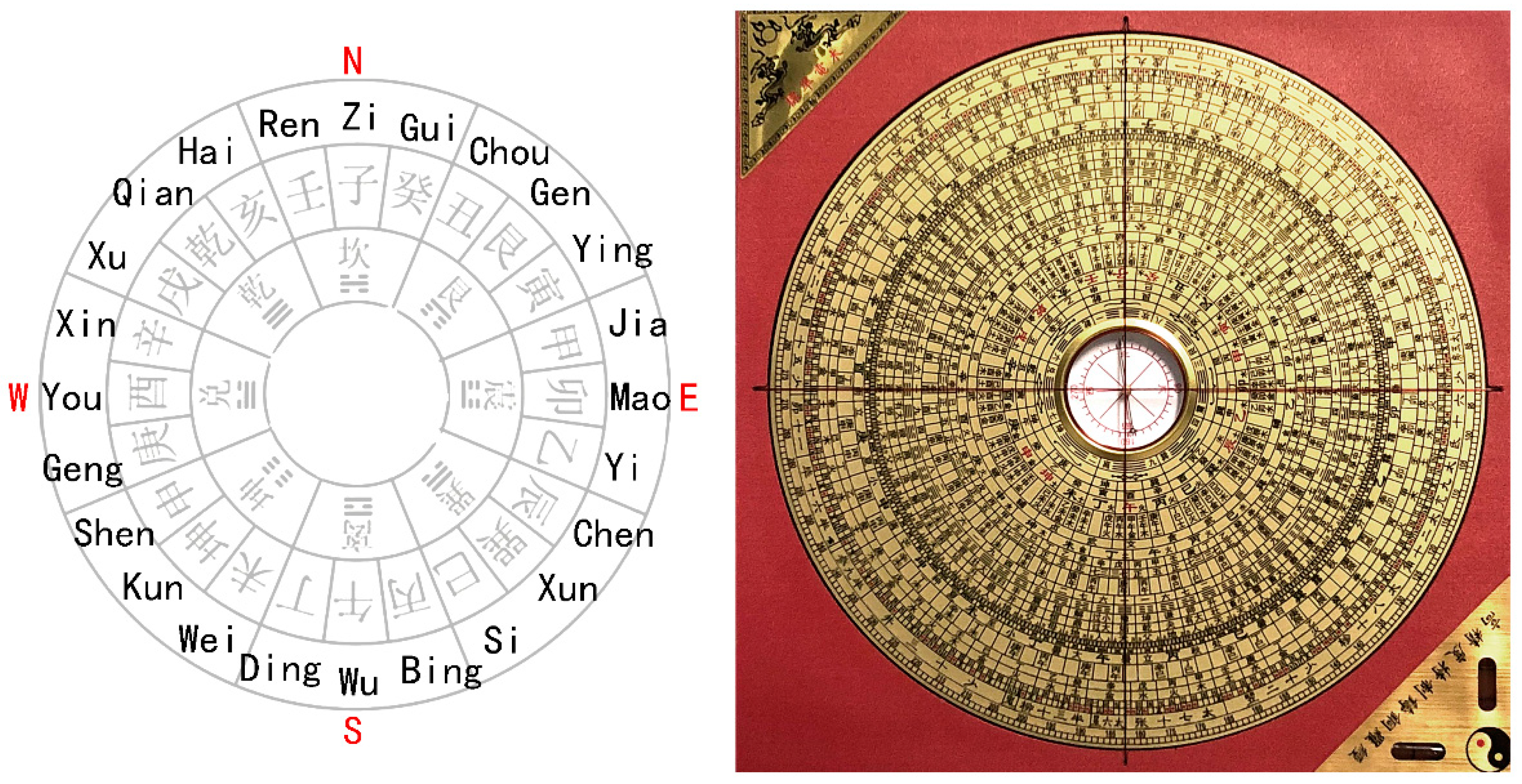
The theory of geomancy is divided into two schools: the Form School and the Compass School (based on previous translations[13]), also known as the Jiangxi School and the Fujian School. By the late Tang Dynasty, the southeastern coastal region of Fujian, which was relatively well-developed, had already established a systematic theory of Compass Feng Shui. Since the site selection and surrounding environmental design of ancestral halls in southern Fujian placed great emphasis on the influence of Feng Shui, the Fujian Compass School particularly focused on orientation. The widespread use of the luopan, designed based on the 24 Shan method, provided an early practical foundation for the precise incorporation of angles into research[14].
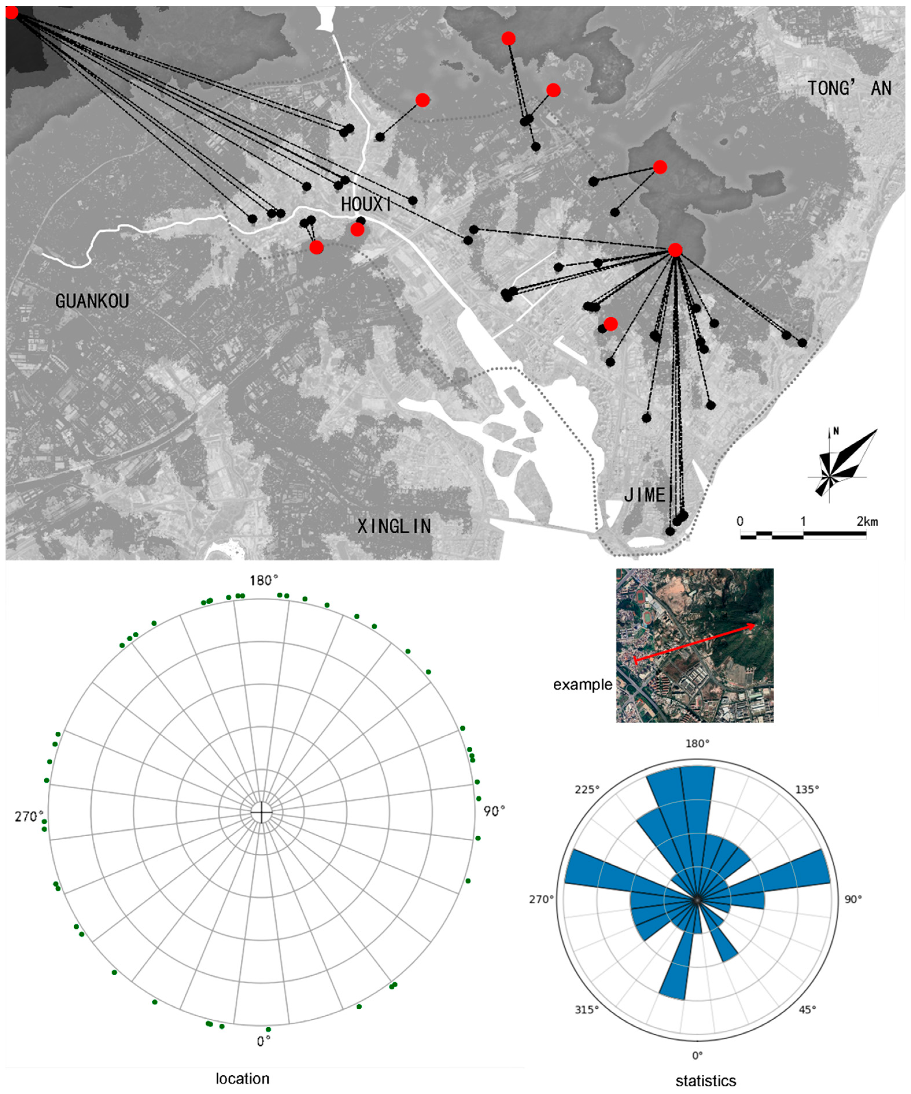
Thus, we can hypothesize that the ancestral halls under study were originally subjected to geomantic evaluation using a luopan by feng-shui masters before their establishment. The spatial orientation characteristics of the halls and their surrounding elements could be reverse-revealed through systematic research focused on angles. This is the origin of the concept of "reverse geomancy" in this study: forward geomancy involves observing the larger environment, using the luopan to determine the site and orientation of an ancestral hall, and then modifying the surrounding environment based on geomantic principles or other needs[15]—a process that evolved from ancient times to the present.
In contrast, "reverse geomancy" refers to systematically recording the locations and orientations of ancestral halls and surrounding elements today, mapping them back onto a 24-part circular division. By analyzing this data, we can identify the spatial characteristics of local villages, summarize the general principles of ancient feng shui practices, and reconstruct the evolution of villages from ancient times to the present (Figure 5).
Dividing the circle into 24 parts for statistical purposes is not because it is scientific method, but because it aligns with the feng shui traditions of southern Fujian. By using the same division method that was applied during the construction and maintenance of these structures, we can reverse-build the patterns of architectural activity. If other regions follow different site-selection traditions, the division method for statistical analysis should also be adjusted accordingly.
2.3. Focused Elements
Under the research framework and process of "reverse geomancy" established in the previous section, this subsection will elaborate on the objects to be recorded.
The research involves recording the location and precise orientation of ancestral halls, the direction of the nearest surrounding mountains relative to the halls, the outline of the village where the hall is located, the positions of trees within 100 meters, the outline of nearby ponds, and the layout of the square in front of the hall. Additionally, it requires documenting the location and orientation of three types of man-made structures: temples, communes, and stages. The specific reasons for recording these elements will be detailed in Section 3.
2.4. Recording Methods
This subsection will elaborate on the recording methods and the tools required, as well as discuss considerations regarding precision.
For each ancestral hall, the coordinate system's reference point is chosen as the main entrance of the hall. The selection of the main entrance holds practical significance in feng shui and is also convenient for positioning, as it does not require entering the hall's courtyard (since the main entrance of some halls is not open to non-family members). Although we refer to the compass for angle division, in practice, the study determines the positions of research objects using satellite imagery combined with laser rangefinders and compasses. The luopan was only used to determine the orientation of buildings, as its straight edges are advantageous for aligning with the exterior walls of structures.
The following are some potential sources of error:
1) When recording village boundaries, ponds, and squares, high-precision satellite imagery data was primarily used for manual tracing. This may result in errors of several meters, especially since village boundaries are sometimes difficult to define.
2) The magnetic declination in the Xiamen is approximately 1°50′. This error was corrected when recording data obtained using a compass. Considering that the magnetic declination was different when these ancestral halls were originally built, it is difficult to reconstruct the magnetic declination at the time of their construction. However, this error would not exceed 1°. Additionally, surrounding environmental factors and solar activity may also cause magnetic field disturbance errors.
3) When recording the positions of trees, due to canopy obstruction, measurements could only be obtained on-site. While the distance error from laser rangefinders is almost negligible, angular errors may still exist.
Considering the magnitude of the above errors, the orientation of ancestral halls was recorded with an angular precision of 0.1°, while other elements were recorded with an angular precision of 1° and a distance precision of 1 meter. Given that the 24 compass directions correspond to 15° intervals, the probability of any object being placed in the wrong interval is less than 10%. After statistical analysis of dozens to hundreds of objects, this level of angular precision should not affect the conclusions drawn.
2.5. Data Collection
The field data collection for the study subjects took place from December 2023 to August 2024. The majority of villages experienced minimal changes by now (2025), except for Yannei Village and Dunshang Village, which were demolished due to the expansion of Xiamen North Railway Station. These serve as examples of how urbanization can lead to the complete disappearance of the feng shui patterns of villages under study.
The satellite map data from Google Earth was extracted in October 2024, so the newer layers of satellite photograph are not accepted into this research.
All data are categorized into xlsx or csv files. All data contain precise geographic information are not allowed to be uploaded into the internet according to security reason so we can provide the data contain relative locations only.
3. Results and Analysis
3.1. The Geomancy of Ancestor halls
This section presents the geomantic characteristics of the ancestral halls, specifically including the orientation of the halls themselves, the relationship between the halls and nearby mountains, as well as the relationship between the halls and the villages.
Figure 6.
the orientation of ancestral halls.
In terms of the orientation of ancestral halls, there are halls facing various directions, with the highest number (8) oriented 15°south of west. In northern China and the Yangtze River basin, ancestral halls are often roughly oriented to face south, as this facilitates better lighting and the accumulation of southern "Yang energy." However, in southern Fujian, where the latitude is approximately 24°N and very close to the tropics, the region is naturally hot and rainy. As a result, the need for lighting and "Yang energy" is reduced, leading to a wide variety of hall orientations.
Nevertheless, south-facing orientations are still considered favorable, with 11 halls oriented toward the south. However, there are almost no halls facing directly south. This is because, while south-facing directions are generally auspicious, the directly southern "Jia-Wu" direction is considered highly inauspicious, associated with "financial ruin and family destruction." In contrast, 15°south of west, known as "Ding Shan" includes the "Xu-Wu" and "Xin-Wei" directions, which are regarded as highly auspicious. The "Xu-Wu" direction is believed to bring prosperity and wealth to all family branches, while the "Xin-Wei" direction is said to bring thunderous success. Additionally, the region experiences prevailing northeasterly winds in winter, so a slightly westward deviation from south can help reduce the impact of winter winds. However, the feng shui requirements for ancestral hall orientation are often tied to the specific history and aspirations of the family, making the diversity in actual orientations unsurprising.
Using GIS tools, we can calculate which mountain appears relatively highest in the view from each ancestral hall. This mountain usually plays a role in the feng shui considerations of the hall. By mapping the mountain's location onto the 24 cardinal directions of the hall's orientation, it can be observed that mountains are more frequently located behind the hall than in front. Among 45 ancestral halls, 30 have the most prominent mountain situated at the rear. In Chinese feng shui, there has long been a tradition of identifying the "ancestral mountain" or "minor ancestral mountain," with the belief that having such a mountain behind a residence or village is more auspicious. However, when ancestors or feng shui masters selected an ancestral mountain in ancient times, it was common—but not necessarily required—to choose the highest peak in the view. Additionally, feng shui masters often considered a combination of factors, such as having the ancestral mountain at the back while aligning the hall toward specific directions, such as "Ding Mountain." Therefore, the influence of the highest mountain's position is relatively limited.
Figure 7.
nearest mountains and their direction from ancestral halls (from this figure to figure 20, the 0° in compass means the direction of the front gate, not the direction of south.).
Figure 7.
nearest mountains and their direction from ancestral halls (from this figure to figure 20, the 0° in compass means the direction of the front gate, not the direction of south.).
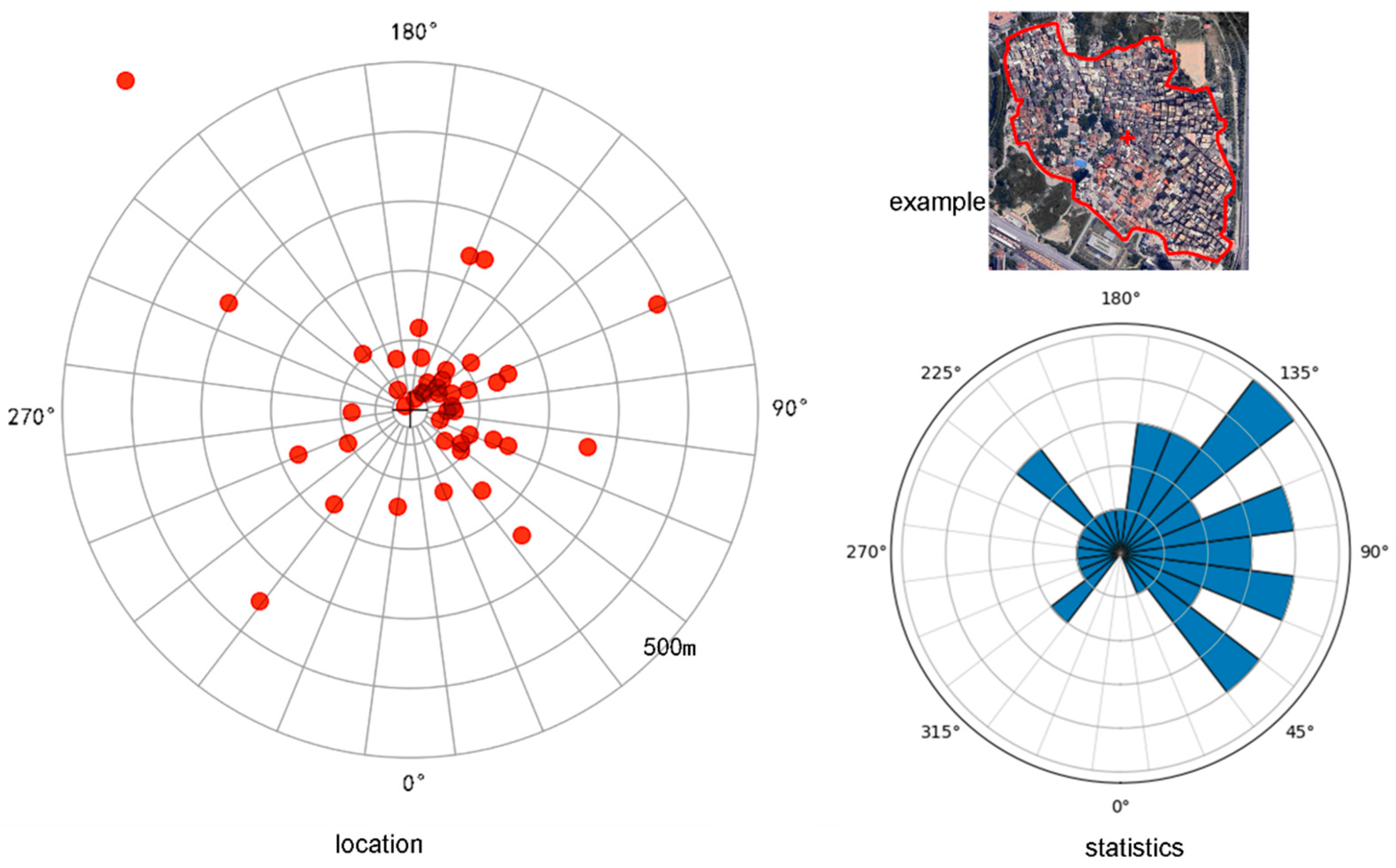
The outline of the village where the ancestral hall is located has been drawn on the map, as shown below. From this, we can extract the geometric center of the village to analyze the relationship between the ancestral hall and the village. It can be observed that the village center may be situated in various directions beyond the front of the ancestral hall, most commonly to the rear left of the hall. Prior to this study, earlier researchers often generalized those ancestral halls were located at the exact center of villages, but this does not appear to be entirely accurate. Notably, no village boundary is found within 40 meters directly behind the ancestral hall, whereas in seven cases, the boundary appears within 40 meters directly in front of the hall. In these villages, the ancestral hall often serves as a gateway, visible just a few steps after entering the village from the outside.
Figure 8.
The outline of villages.

Figure 9.
The outline of villages within 60 meters.
Statistical analysis reveals that the center of a village is often located to the left and backside of the ancestral hall. If we consider that the ancestral hall was constructed earlier than the majority buildings of the village, it can be inferred that newer constructions tend to develop towards the left and rear of the ancestral hall. This stem from certain feng shui practices aimed at seeking the blessings of ancestors, or perhaps out of reverence, avoiding construction in front of the ancestral hall. Alternatively, it could be due to the orderly division of family property over time, with houses for descendants tending to extend towards the left or rear (considered relatively humble directions). The specific reasons may result from a combination of factors, but these elements collectively contribute to the spatial pattern of the ancestral hall being near the village entrance, with the village itself situated to the left and rear.
Figure 10.
The location of village centers.
3.2. Patterns between Halls and Nature
This section focuses on the spatial pattern characteristics of two natural landscape elements within the village that pertain to the relationship between humans and nature: ponds and trees.
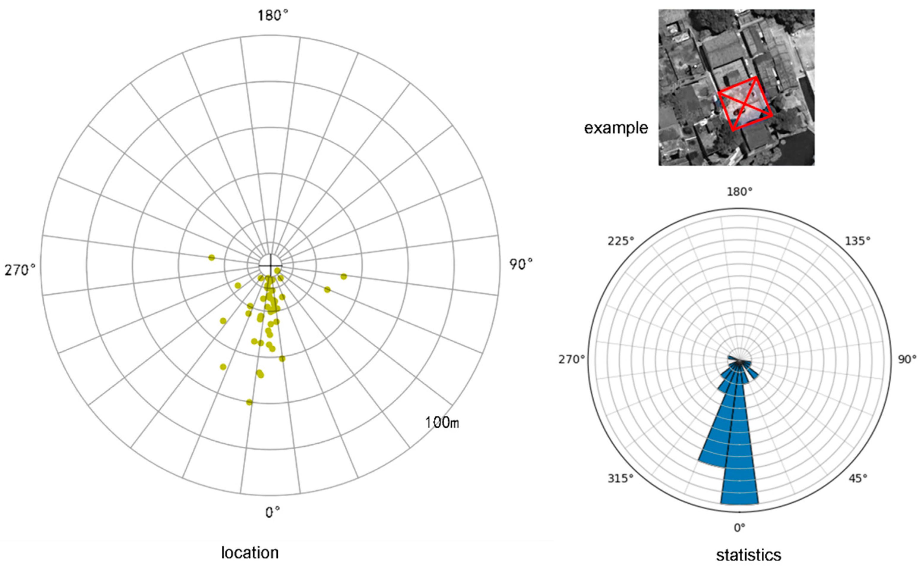
Not every village has a pond near its ancestral hall. In this study, a total of 23 pond outlines were recorded, and their geometric center positions were determined. The relationship between the pond outlines and the orientation of the ancestral halls is shown in the diagram below. It can be observed that the vast majority, 19 ponds, are located in front of the ancestral halls, with the centers of 15 ponds situated within the Kan trigram (i.e., within 45° directly in front). In terms of distance, approximately half of the pond shorelines are within 40 meters in front of the ancestral halls.
Figure 11.
The outline of ponds.
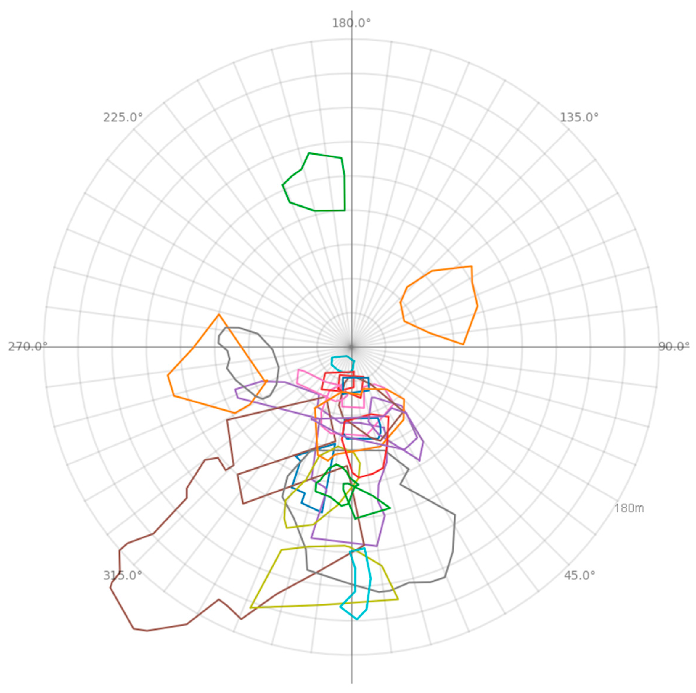
Ancient Chinese architecture was predominantly constructed using wooden structures. The ponds within villages could serve as a water source, playing a role in fire prevention, while also being used by villagers for washing clothes (drinking water generally came from more sanitary wells). Some earlier studies also indicate that ponds contribute to the formation of localized microclimates, improving livability. Ponds specifically located in front of ancestral halls are referred to as "feng shui ponds" and are believed to have the function of attracting wealth. Feng shui ponds can be categorized into "yang ponds" and "yin ponds." Yang ponds are built in certain locations within villages or residential areas to enhance the feng shui conditions of the living environment, while yin ponds are mainly constructed in front of ancestral halls, temples, or tombs.
Figure 12.
The location of pond centers.
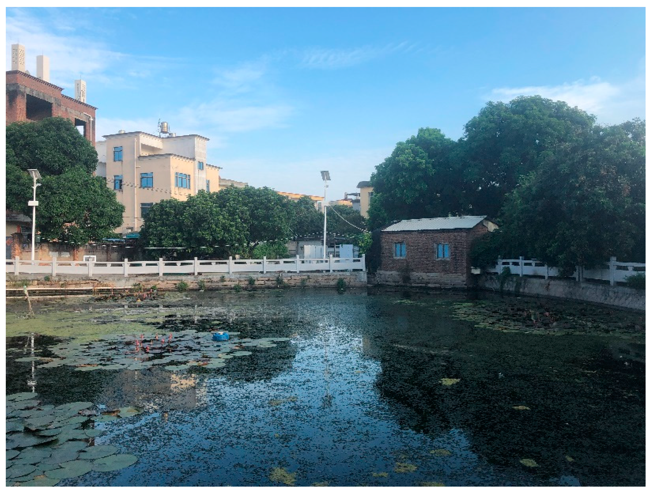
Village feng shui ponds are typically formed by diverting water from natural lakes or rivers and then enhancing them with artificial construction. In cases where natural conditions are not available, ponds are created through manual excavation, a process commonly referred to as "water replenishment." In recent years, local governments have taken the lead in maintaining water quality and repairing the shoreline of these ponds, improving their safety for children and eliminating unpleasant odors or mosquito breeding. For instance, the feng shui pond located in Xiheng is equipped with stone railings and features aquatic plants, contributing to the beautification of the village environment.
Figure 13.
Pond in Xiheng village, covered with lotus.
The village contains a diverse range of trees, making it difficult to conduct a comprehensive inventory. This study focuses on documenting all types of trees located within 40 meters of the ancestral hall's gate, as well as ancient trees over 80 years old or groves consisting of more than five trees located within 100 meters of the ancestral hall's gate. Their locations are represented in the diagram with small dots, large dots, and translucent circles. In this study, all ancient trees are banyan trees.
Figure 14.
The location of trees.
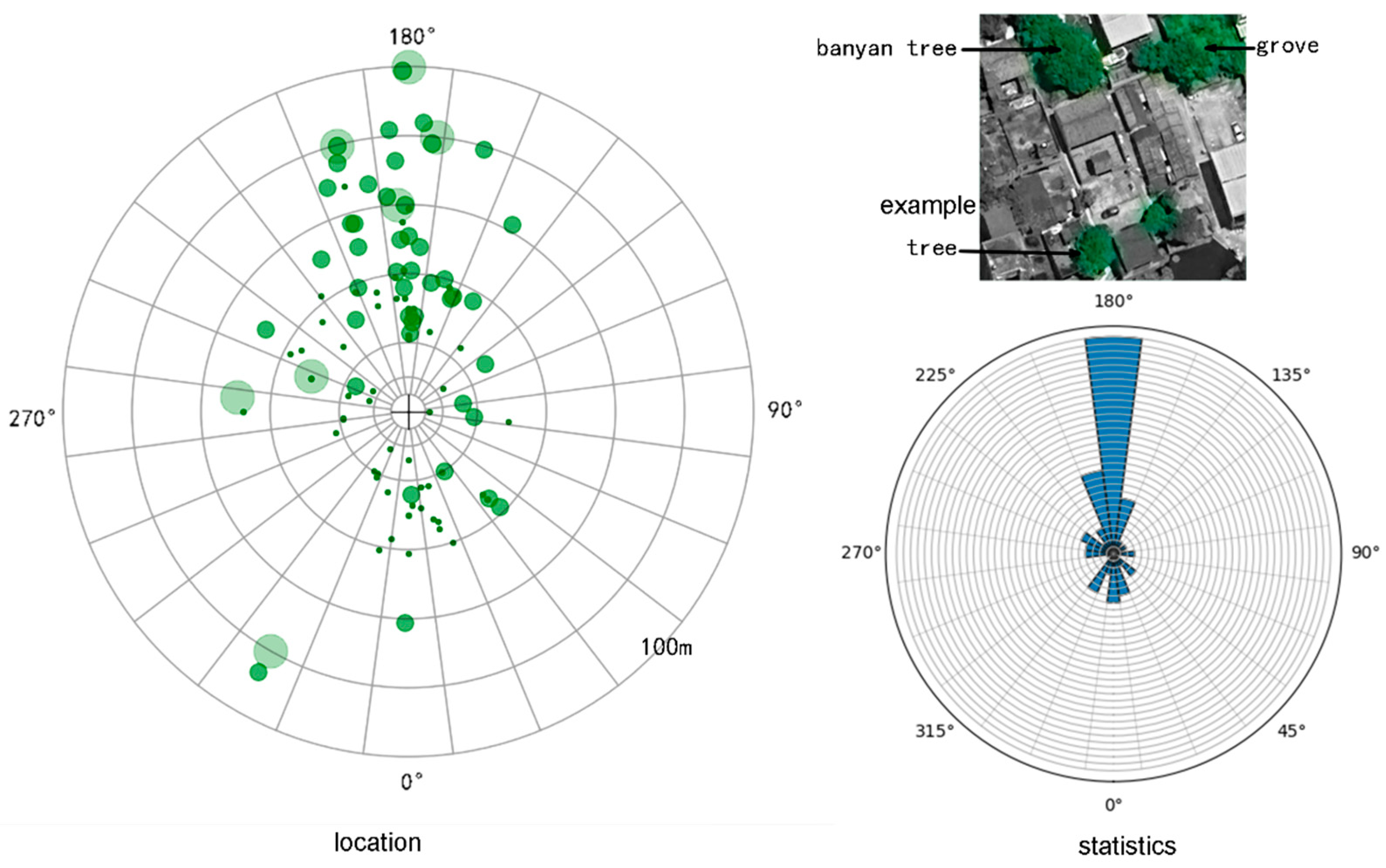
Statistical analysis reveals that the majority of trees, particularly banyan trees, are concentrated directly behind ancestral halls. These trees are generally regarded as Feng-shui trees, most of which are over a century old, with some even boasting several hundred years of age. Although banyan trees are native to southern Fujian, they are not commonly found in the wild on the plains. Therefore, every banyan tree in these villages was planted by the ancestors of the community.
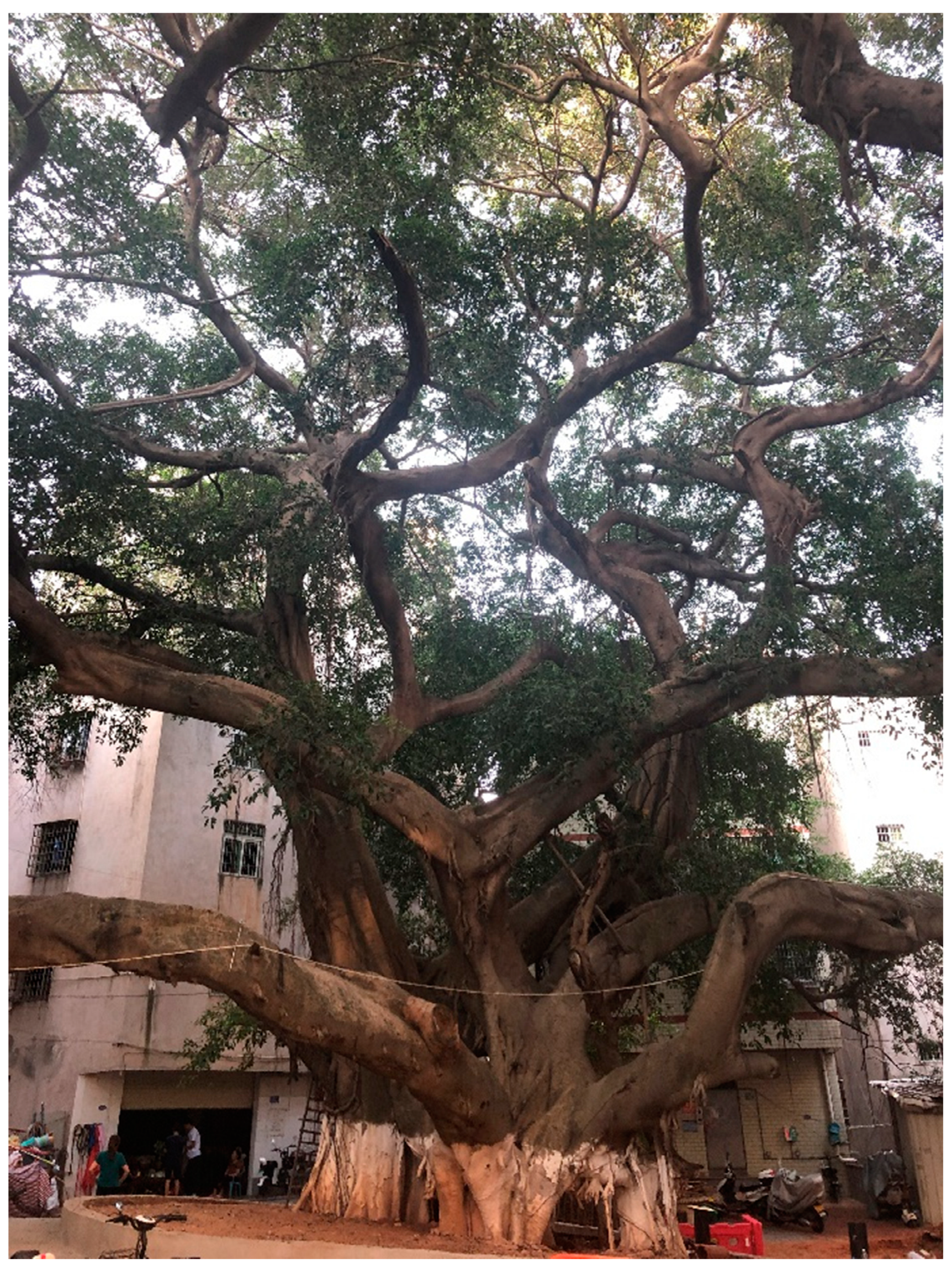
From a historical and cultural perspective, banyan trees hold profound cultural significance in southern Fujian and are imbued with numerous auspicious Feng Shui connotations, such as symbolizing the prosperity of the village, flourishing populations, longevity, happiness, and tranquility, as well as wealth and honor. In religious beliefs, banyan trees are thought to possess spiritual qualities and are believed to protect villagers, which is why many rituals are conducted beneath them, often accompanied by small shrines at their base. Accordingly, planting banyan trees behind ancestral halls is seen as a way to channel their spiritual power to safeguard the clan. As a result, in many stories from villages in Fujian, ancient trees and ancestral homes are mentioned together. For instance, the ancestral hall in Guanzhen Village is said to have been built 500 years ago, with the banyan tree planted around the same time. Once the banyan tree grows tall and expansive, it provides a large shaded area beneath it, offering a cool retreat for villagers during the summer. This reflects the foresight of the ancestors in planning for harmonious coexistence between humans and nature.
Figure 15.
The great banyan tree in Dong’an village.
Some of the forests located closer to ancestral halls serve as Feng-shui forests, functioning similarly to Feng-shui ponds. By positioning a forest in an appropriate location, it can block specific directional "Sha Qi" (negative energy), thereby protecting the clan from misfortune. Sha Qi often corresponds to a straight road or an open area, which in practical terms reflects the need to enhance privacy, avoid traffic noise or shield against strong winds. Most of the Feng Shui forests observed in this study consist of longan trees. This type of tree is well-suited to the local climate, requires minimal maintenance, and produces longan fruit. In addition to providing Feng Shui benefits, it also offers economic value.
3.3. Artificial environment
This section discusses the human-made features in the village, including the square in front of the ancestral hall, as well as three types of buildings with distinct functions and backgrounds: temples, communes, and drama stages.
The open space in front of ancestral halls naturally aligns with feng shui principles, ensuring smooth energy flow and preventing any blockage of fortune. However, its primary purpose is to serve as a communal gathering area for village life, functioning similarly to the open spaces in front of churches in Western villages. During ancestral worship ceremonies, this plaza can be used for setting off firecrackers, erecting temporary structures, and placing offerings. From images, it can be observed that while a few plazas may extend to the sides or even the rear of the ancestral hall to increase their overall size, most plazas are strictly aligned with the direction of the main entrance of the hall, forming a rectangular space in front of it. These plazas vary in length from 5 to 50 meters, with widths generally ranging from 15 to 25 meters. The vast majority of these plazas are located in the Wu Shan or Ding Shan directions relative to the ancestral hall, meaning they either strictly follow the hall’s central axis or deviate by 10 to 20 degrees toward the more auspicious Ding Shan direction.
Figure 16.
The outline of plazas.

Figure 17.
The location of plaza centers.
Ancestral halls are the physical embodiment of ancestor worship, while in the belief system of the southern Fujian, the worship of deities also holds significant importance. Temples serve as the places where these deities are enshrined. Some villages have larger, independent temples built on their outskirts, which attract worshippers from a broader area. These temples are designed with their own distinct spatial axes and considerations of feng shui. This article, however, focuses on temples located within close proximity to ancestral halls (within 100 meters). The deities enshrined in these smaller temples often serve as guardian spirits for the village or clan.
Figure 18.
The location of temples.
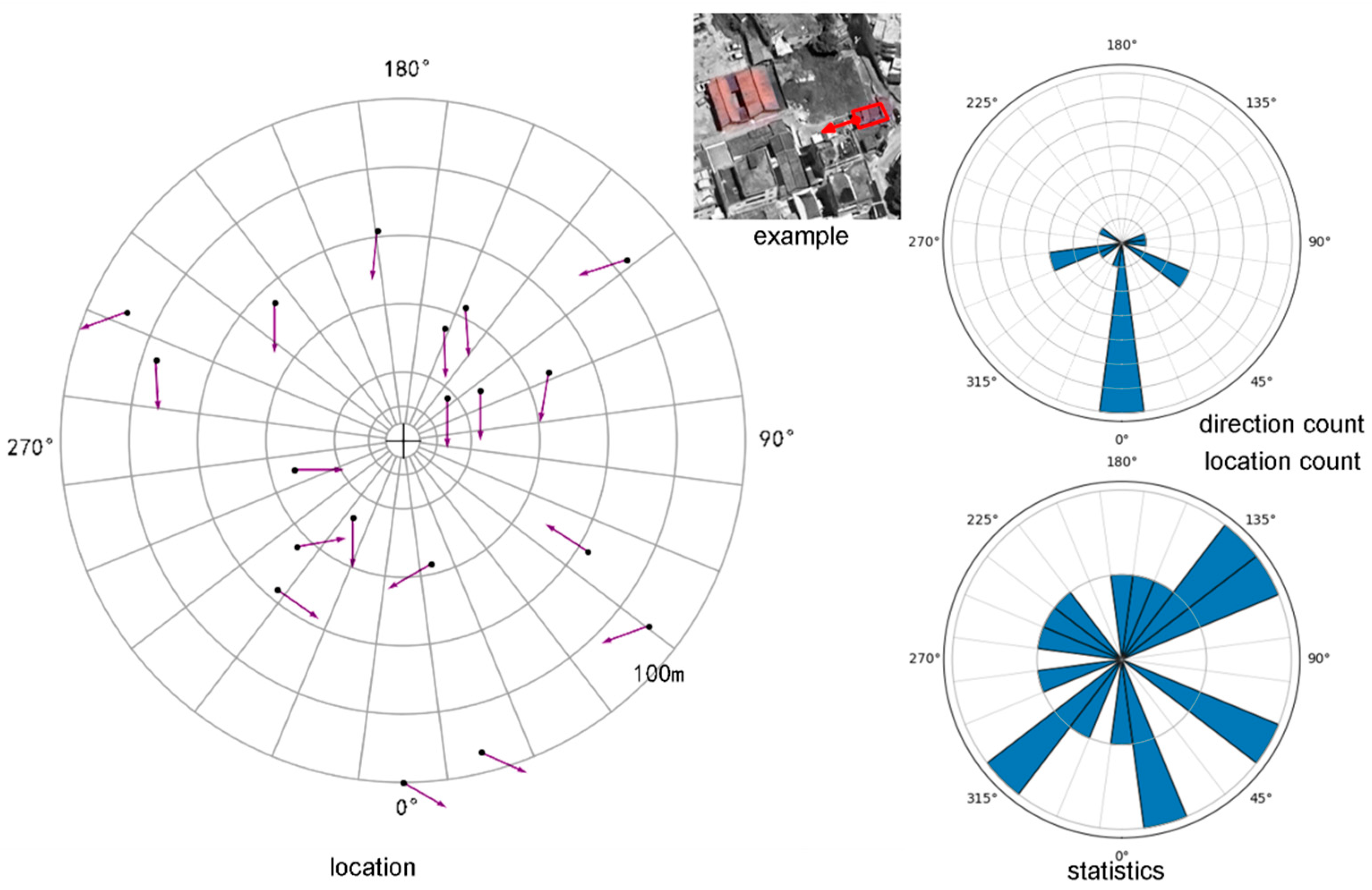
Figure 18 illustrates the location and orientation of temples near the ancestral hall. It can be observed that the distribution of temple locations does not follow an obvious pattern, but a considerable number of temples share the same orientation as the ancestral hall. There are two possible explanations for this: First, for nearby locations, favorable Feng Shui orientations are often similar, leading both the ancestral hall and the temples to adopt this specific orientation. Second, after the ancestral hall was established, the village developed a fixed architectural layout, standardizing the orientation of nearby buildings. When temples were later integrated into this layout, they tended to align their orientation with that of the ancestral hall. Regardless of the explanation, the practice of temples and ancestral halls adopting the same orientation is indeed a common spatial pattern in Jimei villages.
The structures aligned in orientation are not limited to temples but also include an object we had not previously envisioned: commune buildings. People's communes were a unique architectural type during the socialist transformation of the 1950~1970s. Due to the reorganization of village administrative units at that time, not every village necessarily had a commune building, and some of these buildings have since been demolished. Among the nine remaining commune structures located near ancestral halls, five exhibit the characteristic of sharing the same orientation as the ancestral halls (Figure 19). Since ancestral halls predate commune buildings, it is evident that the orientation of these commune structures was directly or indirectly influenced by the ancestral halls. Society in the 1960s was not keen to “feudalistic superstition” so it was impossible for commune buildings to followed ancestral halls’ direction for geomancy reason. It was probably for use the same plaza to gather people or just to satisfying the villagers as they would find commune building showed respect to their tradition in southern Fujian.
Figure 19.
The location of commune.

Finally, we turn our focus to a highly functional structure: the drama stage. Among the 45 ancestral halls, 23 are equipped with drama stages. These stages are spaces specifically designated for performances. It is important to understand that while villagers are free to watch the performances, the primary audience for these traditional drama performances is the ancestors and deities[16]. Therefore, performances are always oriented toward the ancestral hall or temple (Figure 20). In the past, rural stages in the southern Fujian were often simple setups: either iron frames erected on earthen platforms with curtains draped over them for performances or temporary wooden and bamboo platforms constructed as needed for drama performances. In recent years, the local government has further promoted drama culture by encouraging villages to build permanent drama stages. Most of these stages are meticulously aligned with the central axis of the ancestral hall, positioned at the far end of the square, and directly facing the hall. A smaller number of stages are aligned with nearby temples, having been originally built to honor the deities. In most cases, the ancestral hall, square, and drama stage form a strict axial relationship.
Figure 20.
The location of drama stage.
4. Spatial Patterns and Examples
Through the research conducted in the previous section, we can construct a "typical" spatial pattern of ancestral halls that a Jimei village should possess. This spatial pattern can be summarized through the dimension of time.
- 1)
- When ancestral halls were established, there might already have been a feng shui pond (yang pond) in front of the site. Alternatively, after the ancestral hall was built, people might excavate a feng shui pond (yin pond) in front of it to enhance water features. Regardless of the scenario, it is highly likely that a pond would eventually form in front of the ancestral hall, typically located about 40 meters from the main entrance, and generally no more than 80 meters away.
- 2)
- Shortly after the ancestral hall was constructed, villagers would plant banyan trees behind the building to gain feng shui benefits. As a result, these banyan trees are now several hundred years old. Some are contemporaneous with the ancestral hall, while others were planted later, possibly as replacements for older trees that had died. Additionally, when specific feng shui needs arise, villagers may plant feng shui forests.
- 3)
- As the village expanded over time, some villages grew to surround the ancestral hall, placing it near the center of the settlement. In other cases, the village primarily developed behind the ancestral hall, leaving it near the entrance to the village.
- 4)
- A plaza is usually left in front of the ancestral hall, serving as a communal space for villagers' daily activities and as a venue for festive worship ceremonies. An open space like this highlights the grandeur of the ancestral hall and prevents obstruction of its ventilation.
- 5)
- Villagers may combine deity worship with ancestor worship by constructing temples near the ancestral hall to share incense offerings and seek divine blessings for the clan. Due to similar geomantic qualities of the location or constraints imposed by the village's spatial layout, these temples are often oriented in the same direction as the ancestral hall and share the same plaza.
- 6)
- During the 1960s, socialist reforms required some villages to build commune buildings. These structures still tended to align with the orientation of the ancestral hall, reflecting the villagers' pursuit of a unified orientation for public buildings across different historical periods.
- 7)
- The tradition of theatrical performances in front of the ancestral hall has existed since ancient times. By the early 21st century, with improved economic conditions in villages and encouragement from the government, the previously simple performance spaces were upgraded into formal stages. These stages utilized the plaza space in front of the ancestral hall and were often positioned directly opposite it, serving both the ancestors and the villagers simultaneously.
The above describes the typical spatial pattern of village ancestral halls in the Jimei area. Some ancestral halls (mostly family ancestral halls) may lack one or several elements due to their lower status. Below are a few relatively complete examples:
Hujing Village, due to the presence of numerous industrial zones nearby, has become a high-density urban village. However, the Hujing Ancestral Hall still retains a complete sequence of pond--theater stage—square--ancestral hall--banyan tree, forming an arc-shaped layout (Figure 21). This creates a distinct low-lying area within the high-density village. Certain social service functions within the village, such as a kindergarten, are also located in buildings nearby, which demonstrates the significance of this space in the social organization of the village.
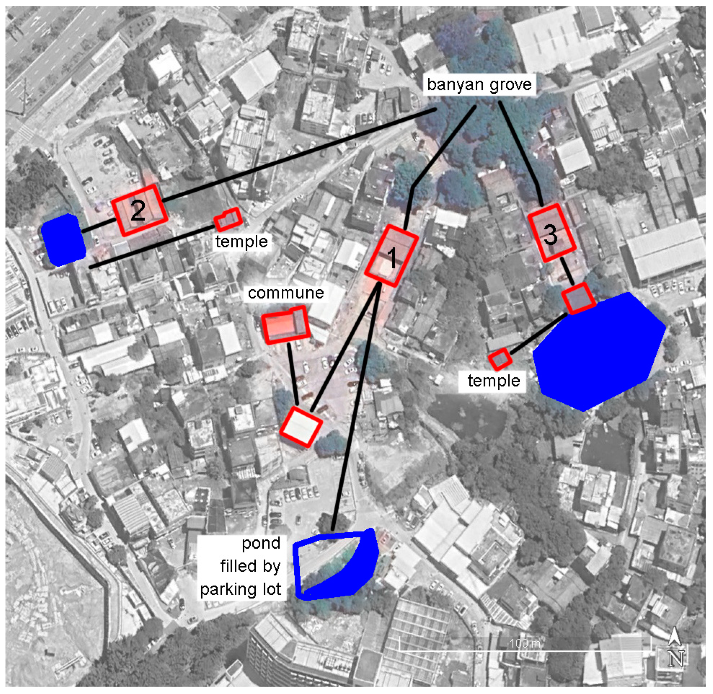
There are three ancestral halls in Xiheng Village (Figure 22), all belonging to branches of the Li family. Ancestral Halls 1 and 2 are located at different village entrances, while Ancestral Hall 3 is situated at the center of the village. In front of Ancestral Halls 1 and 3, there are drama stages. Ancestral Halls 2 and 3 are accompanied by associated temples, and next to Ancestral Hall 1 is the Xiheng Commune. These ancestral halls share the same banyan grove as their backdrop, and each has its own feng-shui pond in front. Among them, the feng-shui pond in front of Ancestral Hall 3 is hexagonal and the most intact; the pond in front of Ancestral Hall 2 is rectangular. The feng-shui pond in front of Ancestral Hall 1 originally existed but has been largely filled in by a parking lot, leaving only a crescent-shaped remnant. This reduction of the feng-shui pond is a notable example of how modern development has disrupted the spatial patterns of the village.
5. Conclusion
This study reached the following conclusions:
1) In the villages of the Jimei region, there exists a statistically verifiable spatial relationship pattern centered around ancestral halls.
2) Certain aspects of this spatial pattern are connected to traditional geomancy, particularly in the orientation of the ancestral halls, the establishment of feng-shui ponds, and feng-shui forests. Other spatial patterns, however, are derived from social needs and the current state of the built environment, integrating spatial elements into the developed villages according to certain principles, such as communal buildings and drama stages.
3) Through the method of "reverse geomancy," the statistical results can reveal the ideas behind village construction from ancient to modern times, uncovering the ways in which geomancy has been involved—as a conclusion, this research approach is feasible.
The study reveals that the spatial integrity of key points within villages is crucial, and any damage to these elements could lead to the loss of the overall spatial pattern of the village. This conclusion provides guidance for regulating the subsequent protection and development of local villages, particularly in the preservation of ponds and feng-shui forests, the reasonable placement of newly constructed drama stages, and the avoidance of disruptions to the existing spatial fabric caused by other new construction projects.
Globally, many settlements may revolve around a specific built environment as the core for organizing spatial patterns, such as squares and churches in Europe, Shinto shrines in Japan, and Marae of the Māori in New Zealand. This article proposes a research method that converts relative spatial relationships into polar coordinate relationships and divides them into scales, thereby enabling the statistical analysis of directional patterns. When applied in different cultural settings, the method should not directly replicate the 24-division approach of Fujian geomancy theory but should instead refer to local cultural traditions to determine the division of directional scales. This method has the potential to be applied in broader settlement research contexts.
Supplementary Materials
The following supporting information can be downloaded at the website of this paper posted on Preprints.org, Figure S1: title, Table S1: title, Video S1: title.
Funding
This research was funded by the National Natural Science Foundation of China, grant number 52278022, and the APC was funded by the National Natural Science Foundation of China.
Data Availability Statement
The data supporting the findings of this study are available in zenodo: https://doi.org/10.5281/zenodo.14755501
Acknowledgments
This research was funded by the National Natural Science Foundation of China, grant number 52278022
Conflicts of Interest
The author declares no conflicts of interest.
References
- Yang, Q., et al., The influence of ancestral temple on the landscape of traditional Chinese villages: Based on landscape pattern analysis and spatial syntax approach. Journal of Asian Architecture and Building Engineering, 2024: p. 1-18. [CrossRef]
- Clark, H.R., The Fu of Minnan: a local clan in late Tang and Song China (9th-13th centuries). Journal of the Economic and Social History of the Orient/Journal de l'histoire economique et sociale de l'Orient, 1995: p. 1-74.
- Xia, J. and S.-c. Chiou, Architectural features and preservation of ancient residential complexes of the changs in Xiangan, Xiamen. The International Archives of the Photogrammetry, Remote Sensing and Spatial Information Sciences, 2015. 40: p. 453-460. [CrossRef]
- Ren, Z., Z. Tang, and B. Li, Construction and Geo-Distribution of the Architectural Characteristics of Clan Ancestral Halls along the Yile–Xijing Historical Trail in Lechang. Buildings, 2024. 14(6): p. 1550. [CrossRef]
- Li, W., et al., The correlation between the architectural and cultural origins of the academies and the ancestral halls in Guangdong, China, from the perspective of kinship politics. Journal of Asian Architecture and Building Engineering, 2024. 23(5): p. 1536-1549. [CrossRef]
- Li, H., Research on Reconstruction Strategy of Faith Space after Urbanization of Suburban Areas ——Taking Lingxia Community in Xiamen as an Example. Chinese & Overseas Architecture, 2021(01): p. 123-126.
- Wang Liangliang, Z.Z., Han Jie, Huang Wencan, Exploration on the Conservation and Development of Traditional Villages in Southern Fujian Based on the Evolution of Village Forms. Urbanism and Architecture, 2019.11. 16.
- Zhang, Y.-Y., Z. Zou, and S.-C. Tsai, From Fishing Village to Jimei School Village: Spatial Evolution of Human Ecology. Int. J. Environ. Sustain. Prot, 2022. 2. [CrossRef]
- Liu, Z., Problems and Solutions of the Developing Traditional Village in Fujian. Journal of Xiamen University of Technology, 2016. 24(04): p. 1-5.
- Illian, J., et al., Statistical analysis and modelling of spatial point patterns. 2008: John Wiley & Sons.
- Mak, M.Y. and S.T. Ng, The art and science of Feng Shui—a study on architects’ perception. Building and Environment, 2005. 40(3): p. 427-434.
- GAO Yun-fei, C.J.-j., WANG Zhen-wu, Ecology Physical Environment Computational Simulation of Ideal Fengshui Position Mode. BUILDING SCIENCE, 2007.06. 23.
- Lee, S.H., Feng-Shui: Its context and meaning (China). 1986: Cornell University.
- Jinguo, C., Life-friendly or Death-friendly—on Fengshui &the Social Cultural Flux in Fujian Province. 2002, Xiamen University.
- Chu, Y.-C., M.-F. Hsu, and C.-M. Hsieh, The impacts of site selection and planning of a historic settlement on a sustainable residence. Applied Ecology & Environmental Research, 2017. 15(2).
- Yuling Zheng: C.Z., Research on the Ritual Dance of "Three Exits" in the Song-Drama of the Minnan Guandi Belief and Customs. Journal of Minnan Normal University, 2022. 1.
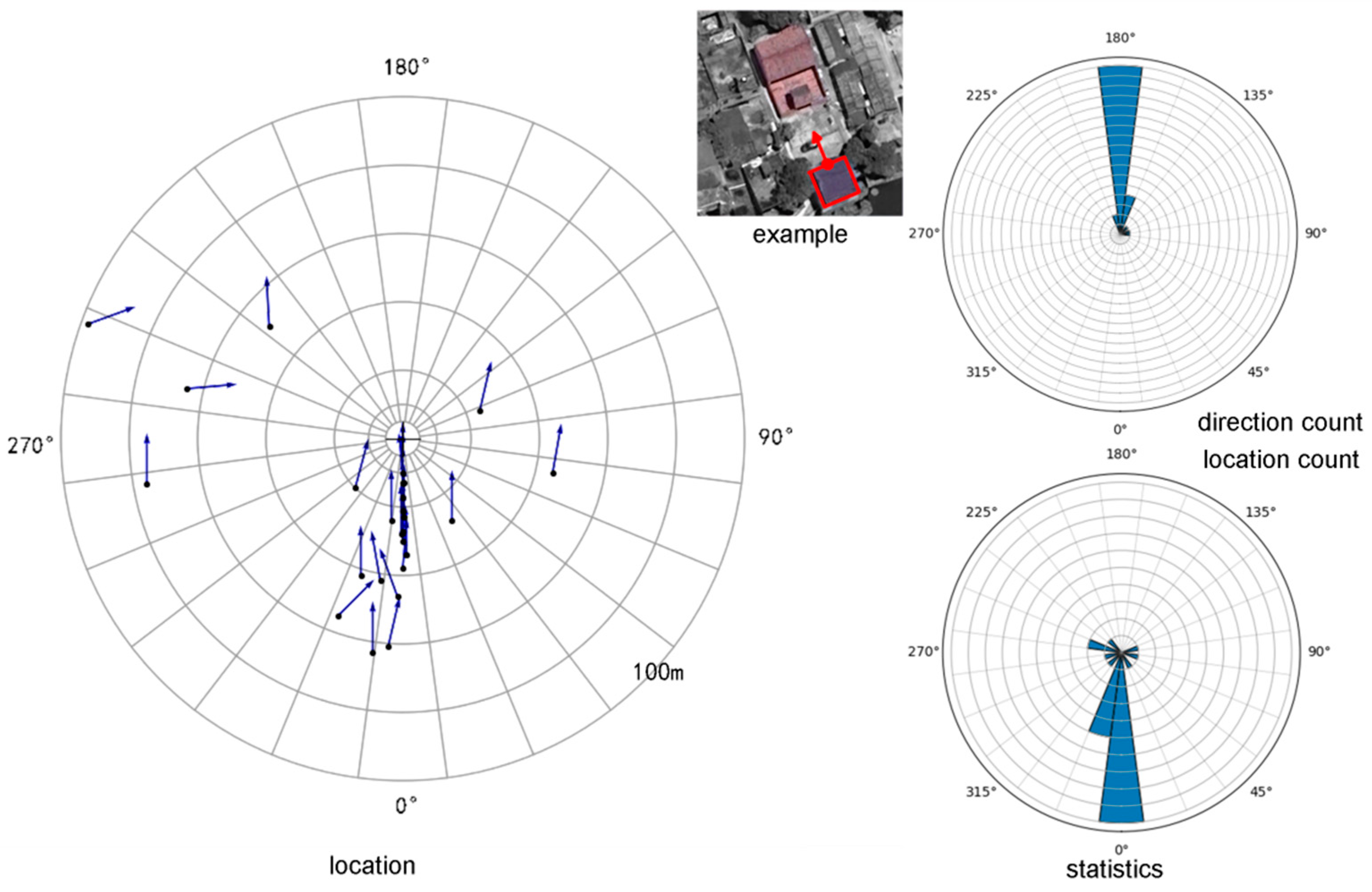
Figure 1.
Location of Jimei.
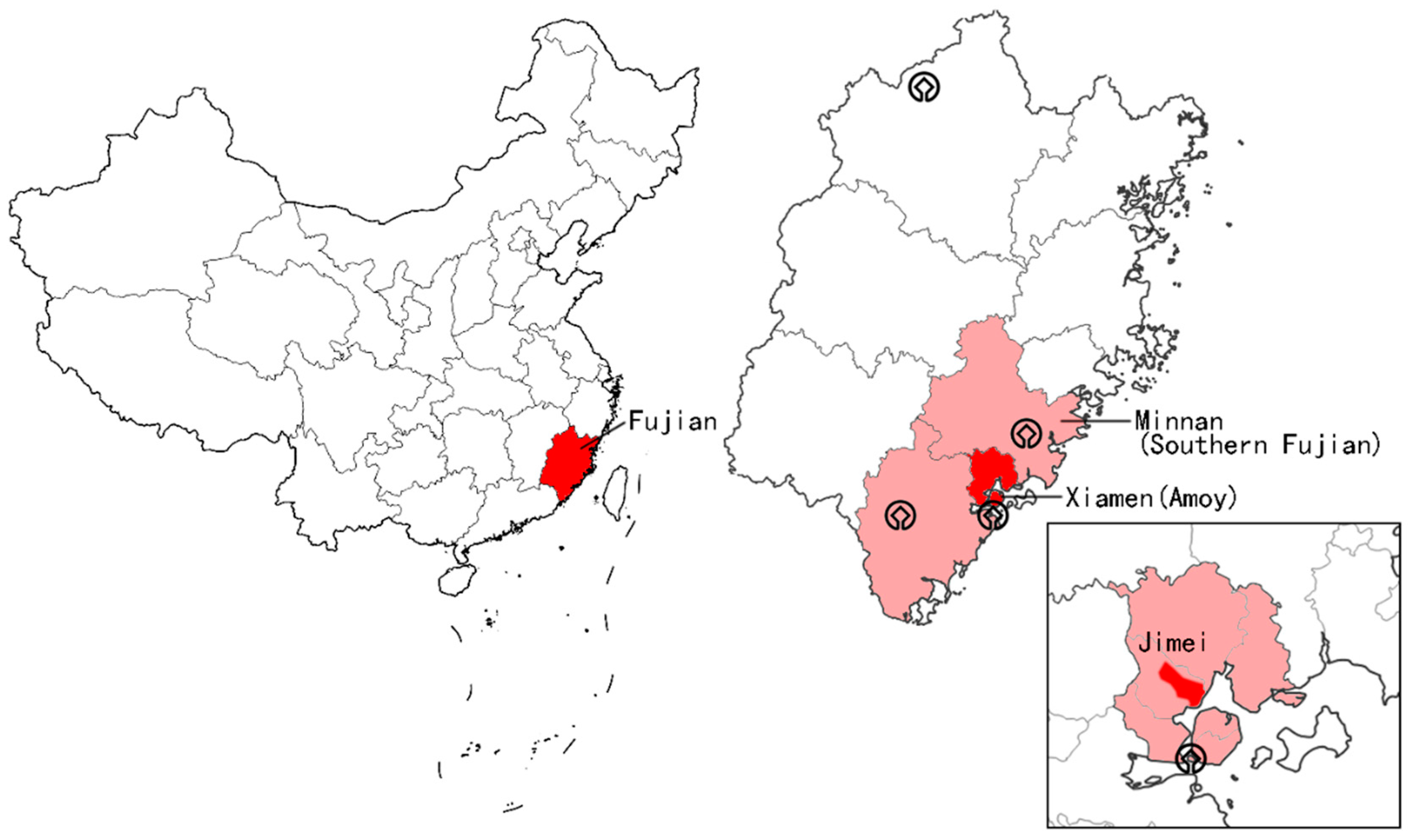
Figure 2.
The location and orientation of the samples.

Figure 3.
Photographs of 45 samples.
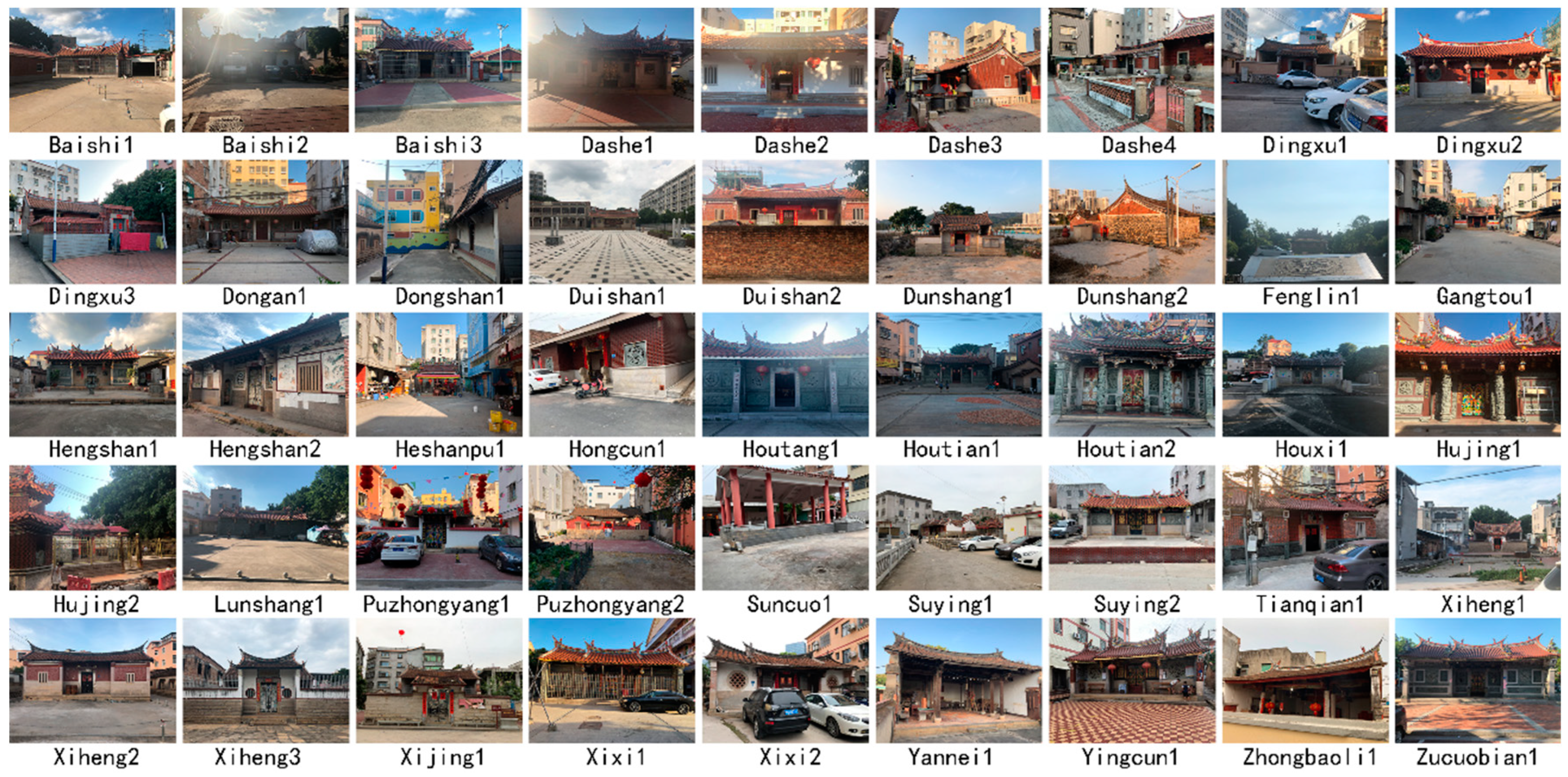
Figure 5.
Forward geomancy and Reverse geomancy.
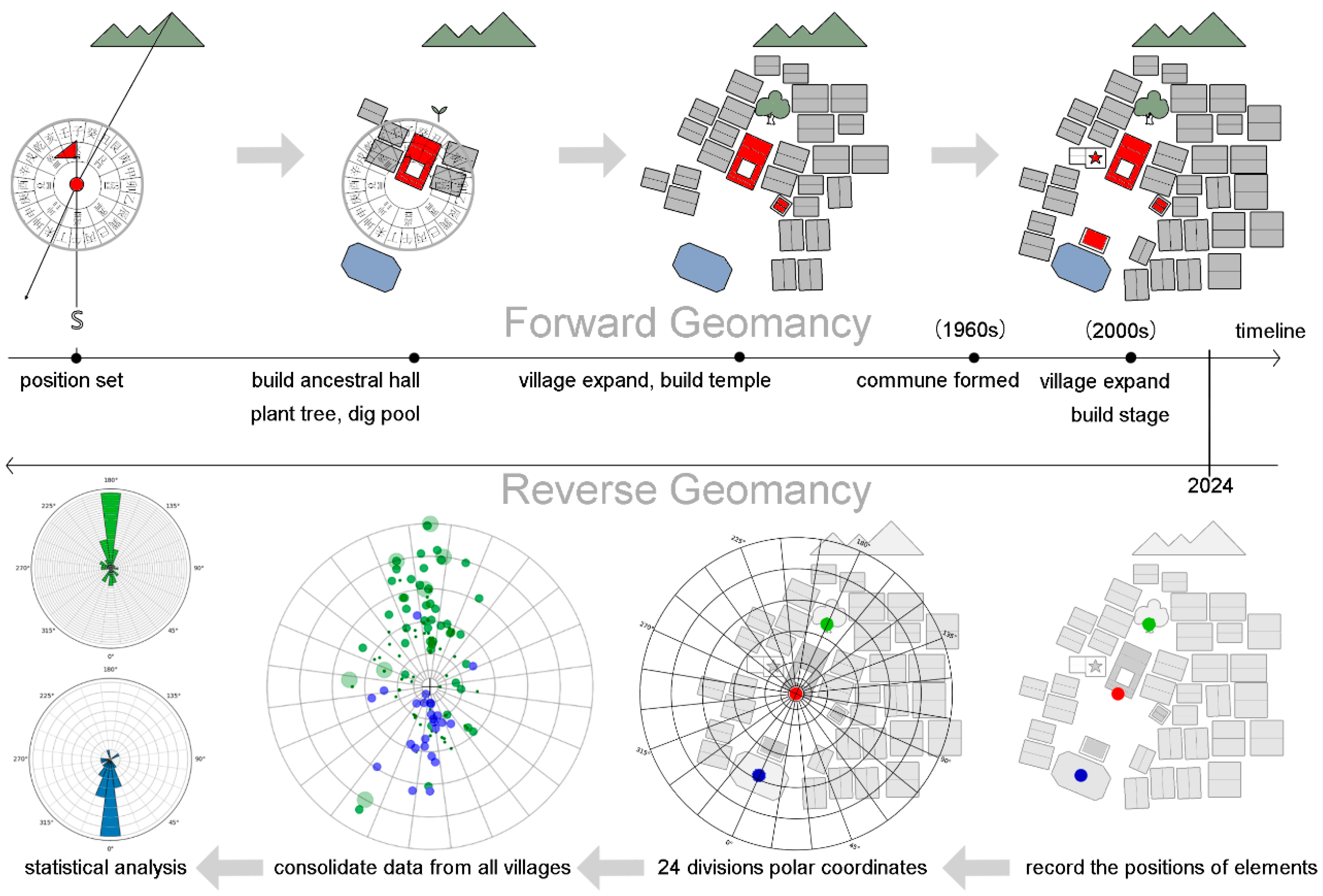
Figure 21.
Hujing village.
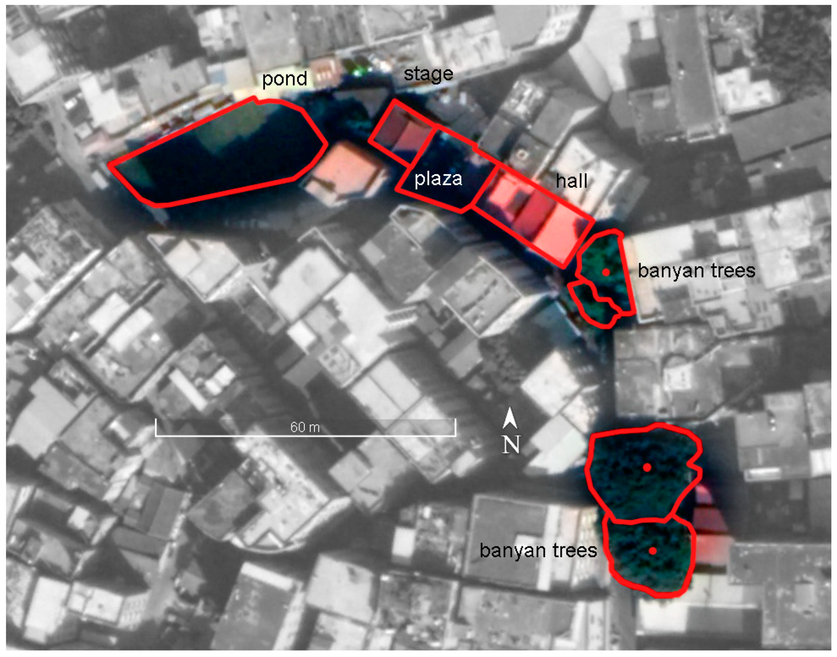
Figure 22.
Xiheng village.
Disclaimer/Publisher’s Note: The statements, opinions and data contained in all publications are solely those of the individual author(s) and contributor(s) and not of MDPI and/or the editor(s). MDPI and/or the editor(s) disclaim responsibility for any injury to people or property resulting from any ideas, methods, instructions or products referred to in the content. |
© 2025 by the authors. Licensee MDPI, Basel, Switzerland. This article is an open access article distributed under the terms and conditions of the Creative Commons Attribution (CC BY) license (http://creativecommons.org/licenses/by/4.0/).
Copyright: This open access article is published under a Creative Commons CC BY 4.0 license, which permit the free download, distribution, and reuse, provided that the author and preprint are cited in any reuse.


