
Submitted:
19 November 2024
Posted:
19 November 2024
You are already at the latest version
Abstract
Long-term impacts of sea-level changes and trends in storm magnitude and frequency along the Mediterranean coasts are key aspects of effective coastal adaptation strategies. In enclosed basins as a gulf, this requires a step beyond global and regional analysis toward high resolution modelling of hazards and vulnerabilities at different time scales. In this paper we present the compound future projection of static (sea level) and dynamic (wind-wave) impacts to the geomorphological evolution of a vulnerable sandy coastal plan located in the south Sardinia (west Mediterranean Sea). Based on local temporal trends in Hs (8 mm yr-1) and sea level (SLR of 5.4 mm yr-1), a 2-year return time flood scenario at 2100 shows the flattening of the submerged morphologies triggering the process of marine embayment. The research proposes adaptation strategies to be adopted to design the projected new coastal area under vulnerabilities at local and territorial scales.
Keywords:
sea level rise
; wave height trends
; coastal vulnerabilities
; flood adaptation strategies
1. Introduction
Coastal adaptation strategies require a full understanding of local relative sea-level change. Due to increased rates of land-ice melting and ocean thermal expansion (Frederikse et al., 2020), global mean sea level (GMSL) has been dramatically rising in a highly non-uniform pattern. Previous studies (Marcos and Tsimplis, 2008; Orlić et al., 2019) show how past sea-level changes in the Mediterranean Sea have deviated from GMSL trends and how large-scale circulation changes in the basin have produced internal spatial variation. The average rate of sea-level rise in the Mediterranean Sea increased from −0.3 ± 0.5 mm yr−1 in the period 1960–1989 to 3.6 ± 0.3 mm yr−1 in 2000–2018 (Calafat et al., 2022). The main source of information on long-term sea-level changes in the Mediterranean Sea are tide gauge records (archive of the Permanent Service for Mean Sea Level, https://www.psmsl.org/) with low geographic density and relatively long records along the European coasts and satellite altimetry observation with better spatial coverage but on shorter intervals (Sea Level Climate Change Initiative (CCI) project of the European Space Agency (ESA), https://climate.esa.int/en/projects/sea-level/). Long-term impacts of sea-level changes along the Mediterranean coasts have gain the attention of the international scientific community specifically on the dynamics of coastal erosion, groundwater salinization and change in natural ecosystems (e.g., Nicholls and Cazenave, 2010).
Interest in changes in local wind-generated wave climate both historically and for future projections is quite recent (see for istance, Bricheno and Wolf, 2018). Aside from a few studies (Meucci et al., 2020; Timmermans et al., 2020; Morim et al., 2021), a reliable analysis of the long-term trends in wind-wave extremes under future climate change scenarios is lacking and this results in a lack of consensus on whether the frequency or magnitude of these extreme events is affected by climate change. Meucci et al. (2020) estimated future projections at the end of the 21st century (2081–2100) in 100-year return period significant wave heights (Hs,100) under two IPCC representative greenhouse gas emission scenarios (Representative Concentration Pathways (RCPs): RCP4.5, intermediate emissions scenario, and RCP8.5, high-emissions scenario) using an intermodel ensemble of seven global wave model runs (WAVEWATCH III v3.14 wave model) forced with independent GCM surface winds, part of the international Coupled Model Intercomparison Project 5 (CMIP5). They found that the Northern Emisphere shows an irregular pattern and only the projected decrease in Hs,100 of -5 to -15% in the mid and low latitudes of the North Atlantic basin is statistically significant.
Timmermans et al. (2020) compared significant wave height climatologies and trends over the recent satellite era (1992–2017) from four recent high-quality global datasets (two products based on satellite altimetry, including products by ESA CCI for Sea State and Ribal and Young (2019), and two ERA5-based reanalysis and hindcast surface wave products from the European Centre for Medium-Range Weather Forecasts (ECMWF). The use of data buoys to study long-term sea state variability from reanalyses and hindcast models is fraught by problems associated with consistency of buoy output and validation methodologies. Although the long-term consistency and accuracy of multimission satellite data depend on careful calibration and quality control (see for instance, Ribal & Young, 2019), these data are attractive in long-term analsys in ocean wave climate thanks to their global coverage, fine spatial resolution, and regular temporal revisits. Trends were estimated by Timmermans et al. (2020) for all the above products for the period 1992–2017 at each 2°×2° grid cell over the full globe using linear regression. While substantial differences in climatologies and trends between the products exist, the trends in seasonal mean Hs, over most of the globe, lie within ±1cm yr−1 for all products. However, the North Atlantic shows much smaller changes which are generally not statistically significant and with no clear sign (i.e. increasing or decreasing). Finally, trends for the buoy data were estimated using both linear and Theil-Sen models (Sen, 1968, Theil, 1992), with similar results as also reported by Ghavanati et al. (2023). Comparing the Theil-Sen slopes with four different models (seasonal AutoRegressive Integrated Moving Average, multiple regression modelling and Generalized Additive Model modelling) Vanem and Walker (2013) found that the different approaches result in reasonable agreement for detecting long-term trends of Hs in the North Atlantic.
In enclosed basins as a gulf, the waves have properties rather different than in a large environment. This is mainly due to their local generation, and they depend more on the quality of winds (coastal orography) and transformation (bathymetry). The signals on the effects of climate change in the Mediterranean are not univocal, in some cases a reduction in wave energy has been recorded (Lionello, 2017), the local climate intensification of the wave more frequent (Bonaldo et al., 2020; Reale et al 2021) for meteorological events linked to winds from the south. Extratropical cyclones are the dominant feature of mid-latitudes (Ulbrich et al., 2009) as in the Mediterranean basin. They mainly form and grow via baroclinic instability, with the available potential energy being proportional to the variance of temperature in the troposphere (Bengtsson et al., 2009). Events with a typical radius of 500 km and an average duration of 28 h (Lionello et al., 2006) and many subregional and mesoscale effects take place, produce a large spatial and seasonal variability. Once the suitability of the Theil-Sen slope for detecting long-term trends is shown, in a prioneer high-resolution analysis of wave climate trends, De Leo et al. (2020) evaluated the spatial distribution of long-term trends of the extremes and the mean Hs in the Mediterranean Sea based on the hourly 40-years hindcast time series (1979-2018) (Mentaschi et al., 2015). While some analogy with the results presented in Young and Ribal (2019), De Leo et al. (2020) showed significant regional variations, the most significant trends in annual maximum Hs being between – 5cm yr−1 and 3 cm yr−1 with positive trends in east Sardinia. The mean and the 98th percentile of Hs produced trend intensities of mm yr−1 and positive trends in west Sardinia. Sierra et al. (2020) show that projected future wave power in the Mediterranean coast of Morocco is very similar to that of the present considering the whole area, although at some specific points there are slight changes that are more evident for the RCP8.5 scenario. Results show a significant increase of the temporal variability of wave power in future scenarios, in particular for RCP8.5. Projected future regional wave climate scenarios at a high temporal-spatial scale (25 km and 3 h) were performed by Casas-Prat and Sierra (2013) with the SWAN wave model (Booij et al., 1999) for the NW Mediterranean Sea, using five combinations of regional-global circulation models (RCMs) forced by the increasingly used midline A1B scenario (IPCC, 2007). For the mean climate, relative changes of significant wave heights (Hs) up to ±10% were obtained, whereas they were around ±20% for the extreme climate; also, an higher intensity and number of storms coming from E-SE and directly affects the wind-sea/swell distribution of coastal stretches that face east, like the Catalan coast.
In micro- and meso-tidal environments, such as those found in the Mediterranean Sea, extreme wave analysis (e.g., Alves and Young, 2003), long-term trend detection (Young and Ribal, 2019) and under future climate change scenarios (Morim et al., 2019), all based on high-quality Hs dataset over many spatial and temporal scales, may have strong implications for urban and spatial coastal planning. All those tools have proved to be effective in defining scenarios for a decision-making process that planners can guide according to future perspectives in urban behaviours (Sulis et al., 2024). The scenarios in urban plans at the local level should be multidimensional as mainly composed by the dimension of the climate change to which this article gives large emphasis, the ecological and historical dimension linked to the needs of protection of the natural heritage and historical-archaeological sites, and the settlement and infrastructural dimension that responds to the need to increase a metropolitan system strengthening.
Based on a widely used methodology, the main novelty of this work is the compound future projection of static (sea level) and dynamic (wind-wave) impacts to the geomorphological evolution of a vulnerable sandy coastal plan. Specifically, we analysed the submersion dynamics of the lagoon barrier systems (Fontolan et al 2012, Antonioli et al 2017) located in the south Sardinia (west Mediterranean Sea) forced by the Sea Level Rise (SLR) process as sum of tectonic mobility, glacio-hydro-isostatic component and induced geomorphological and sedimentological processes of the area, and trends in wave parameters. All these forcings make dramatically complex the projection on the impacts of climate change in this marine-littoral (beach system) and transition (lagoons and river mouth) environments. The research group is questioning the possible effects that a construction process of design scenarios can have on the planning of urban transformations of the territory of La Playa. It is being investigated the significant effects to local and territorial vulnerabilities under the climate projections.
2. Materials and Methods
2.1. Geomorphological Context
The continental margin of Southern Sardinia (Figure 1) is characterized by a submarine depositional system, controlled by Pliocene distensive tectonics. It is divided into several marginal basins (Wezel et al., 1981) with the sedimentary contributions of the various segments of the continental shelf (Lecca et al., 1998). The structure of the southern Sardinian continental margin, as reported in numerous seismic profiles acquired from the 70’s (Morelli and Nicolich, 1990; Blundell et al, 1992; Egger, 1992; Giese et al., 1992; Torelli et al., 1992; Tricart and Torelli, 1994), is characterized by the succession of two deformational regimes. The oldest corresponds to a compressive phase of crustal thickening occurred during the Oligocene – Miocene, contemporary to Sardinia– Corsica microplate rotation and opening of Alghero - Provencal basin (Mascle et al., 2001). The most recent is associated with the phase of rifting of the Tyrrhenian Sea, when tectonics led to a slight thinning of the Earth’s crust. Cagliari basin is the innermost part of the sedimentary system of the entire margin, delimited and controlled by tectonic blocks of southern Sardinian continental margin, in particular by the movements of Mount Ichnusa and Su Banghittu submarines blocks (Fanucci et al., 1976). The morphostructural characters (Figure 1) control the southern Campidano and affect the appearance of the continental shelf and slope (Fanucci et al., 1976) in the Gulf of Cagliari, in fact it is possible to recognize the continuation of the Campidano Graben in the submerged area.
The transition to Holocene marine deposits is marked by deep incisions founded in both coastal plain and continental shelf, these palaeo-valley began their evolution after the Last Interglacial highstand while the highest incision was carved during the MIS 2 low stand. The Holocene sea level rise has been detected studying and dating (14C analyses): seven orders shelf of beach-rock outcropping on the continental shelf the deepest of lay at -45 m shows ages between 9.5 and 9.9 ky BP (De Muro and Orrù, 1998; Orrù et al. 2004); wile not cemented relict beaches bordered the palaeo-lagoon (-39 m) and in the inner band (-35 m) have recently been identified and sampled the submerged back-shore sand dunes.
A buried Punic (2.5 ky BP) paleo-sealevel at -2 m is preserved in the bottom-area Santa Gilla lagoon (Solinas and Orrù., 2006; Antonioli et al., 2007; Buosi et al., 2017).
Santa Gilla Lagoon is located on the W-side of Cagliari (39°12'59" N; 09°02'39" E). It is a NW–SE orientated depression, and roughly deltoid in shape. It connects in the S to the Mediterranean Sea through a narrow channel. On the N shore, the lagoon has two major freshwater inflows from the Flumini Mannu and Cixerri rivers. The average water depth is 1 m, with a maximum of 2 m in the artificial channel connecting the lagoon with the sea.
The lagoon is set on the S end of the. It was formed by the fluvial erosion of Quaternary sediment and was successively filled by the sea during the Holocene as a consequence of combined climate fluctuations and subsidence actions (Pecorini, 1986). After the sea’s Würm regression (stage 2, 15/18 ky), which produced strong erosion of the Tyrrhenian marine sediment (‘‘Panchina Tirreniana” Auct.), the erosional valley was separated from the sea water by a coastal sandy bar that already existed in the Pre-Roman Age (Pecorini, 1986; Ulzega, 1995). This was filled with, mainly sandy-silt, sediment to a thickness of about 50 m from the upper Pleistocene to the present day (Orrù et al., 2004). The silty sand with subordinate gravel, which is attributed to the alluvial contribution of the Flumini Mannu and Cixerri rivers, creates sedimentary bodies on the NW shore of the lagoon.
The sedimentary succession of the lagoon (Figure 2) starts with fluvial and deltaic sediment (sand, gravel, mud, clay) that is attributed to the end of the MIS6 stage and contains grey-greenish lenses with oysters and peat layers. This sediment is followed by the alternation of littoral fine sand and lagoonal silty sand. Based on the ecology of the coralliferous bioconstructions (Peirano et al., 2004), it is possible to assume that this reef was located at approximately -5 m during the maximum high-stand phase (7 ± 2 m). During the building of the modern harbour, a yellowish sandy layer (0.5 m thick) with a Strombus bubonius (=Persististrombus latus) assemblage attributed to the Last Interglacial cycle (MIS 5.5, 125 ky; Ulzega and Ozer, 1982) was also discovered at a depth of 8 m. A paleo-thalweg is recognizable at a depth of 40 m and testifies to the ancient fluvial incision. Heterometric polygenic gravel from alluvial terraces was sampled between a depth of 30 and 35 m. The infilling of the ancient fluvial valleys is composed of material related to the last phases of the Holocene transgression. This consists of muddy fluvial and deltaic sediment containing more gravel in the lower part and becoming muddy upwards. Beach rocks (-1/-1.5 m depth) have been found in the submerged beach of La Playa, whereas typical rocks of the sabkha environment (El-Sayed, 1988) are also present on the edge of Santa Gilla Lagoon.
Minor subsidence of 3.5 m in 5 ky, which is mainly attributable to the constipation process of plastic and peat, has been documented both on the continental shelf in the Santa Gilla Lagoon mouth area (Orrù et al., 2004) and along the round lagoon bands, where the high-medieval settlement of Santa Igia (8th-13th century BC; Fois, 1986; Soddu, 2010) shows an average lowering of about 1.5 m (Pecorini, 1986). GPS measurements evidenced S Sardinia translational movements in a W-SW prevailing direction at speeds of about 1-3 mm yr-1 (Oldow et al., 2002; Devoti et al., 2017).
Erosional processes have affected the coastal system over the past decades, with a shoreline retreatment speed of up to 1.5 m yr-1.
In the innermost area of Santa Gilla Lagoon, and during particularly intense meteomarine events that correspond with extreme rainfall occasions (return time of 5 years), the lagoon hydraulic level significantly increases (about +1.5 m above sea level), causing the flooding of agricultural plains and surrounding urban areas.
The comparison between the geochronological data deriving from drills (Orrù et al., 2004) and the projections of the isostatic model (Lambeck et al., 2011) allows us to confirm that the E coastal plain of Cagliari, and consequently Santa Gilla Lagoon, is an area characterized by low tectonic activity and subsidence processes (about -0.5 mm yr-1). The infilling deposit (peat and muddy sands) of the assial zone of the river paleo-valley may reach a thickness of about 40 m. Compared data retrieved in two other analogue sites: “Portus Herculis” at Malfatano (Porcu, 2013; Orrù et al., 2014) and the submerged building at Sant’Antioco Lagoon (Orrù et al 2011) confirm the reliability of glacial-hydro isostatic adjustment (GIA) modelling prediction models reconstructed for the entire basin of the Mediterranean Sea (Lambeck et al., 2004, 2011).
2.2. SLR Analysis
The global sea level rise rate SLR in recent decades is around 2mm yr-1 (IPCC AR6), but locally vertical ground movements, either due to tectonic activity (subsidence or uplift) (Ferranti et al., 2006; Faccenna et al., 2014, Antonioli et al 2009) and sedimentary subsidence, significantly modified the relative submersion rates of coastal plains. Numerous studies have presented forward-looking hypotheses on global sea level rise for 2050 and 2100 (Rahmstorf et al., 2007; Church et al., 2013) including Sardinia coastal areas. Sea-level change along the Italian coast is the sum of eustatic, Glacial Isostatic Adjustment (GIA) and tectonic factors. The first is global and time-dependent while the latter two also vary with location. The glacio-hydro-isostatic part exhibits a well-defined pattern and is readily predictable whereas the tectonic component exhibits a less regular pattern that is generally of shorter wavelength and also less predictable. Together, these components result in a complex spatial and temporal pattern of relative sea-level change around the central. For the eustatic portion we use IPCC AR6, for GIA the Lambek Model, as regard tectonic we consider this portion of Sardinia stable, with few subsidence in the coastal area of La Playa. In any case the sum of the 3 vertical movement is given by the tide gauges. The data of sea level rise projections for Santa Gilla lagoon were recently analyzed and geological-stratigraphic, geomorphological and geophysical data used in combination were analyzed by comparing them with high-dimensional three-dimensional terrain models (Antonioli et al., 2017; Marsico et al., 2017). This interpretative model was subsequently extended and validated in numerous other cases both in the Italian peninsula and in other coastal plains of the Mediterranean (Antonioli et al., 2020; Deiana et al., 2021). The methodology was further investigated by comparing the forecast hypotheses of drowning of the coastal plains with the data of the Last Interglagial, data that can be obtained from the field investigations on the tidal notch or on the depositional sequences of MIS 5.5, producing a sea level rise of 1.3 mm yr-1 in relation to a significant impact of evaporation processes (Lambeck et al 2011). Another factor that intervenes at the local level in the is the Santa Gilla lagoon is the glacial and hydroisostatic adjustment (GIA). Paleolevel indicators (surveys, beachroks, submerged archaeological structures) in the study area have allowed to verify the geophysical models of the GIA (Lambeck et al., 2011). The GIA component in the western Mediterranean is controlled both by the water load and by the readjustment of the mantle causing a current uplift of the sea in Sardinia of 0.7 mm yr-1.
The complex of geochronological data collected on the sea level rise starting from about 20 ky cal BP using the various paleo-marine level indicators (eg, tidal notches, palaeo-cliffs, depositional terraces, beachrocks, fossiliferous deposits) in Sabta Gilla lagoon have made it possible to reconstruct the SLR curves comparing them with the predicted curves indicating a general trend towards a Next Interglacial Hightstand (Rovere et al., 2016) also in relation to orbital variations (Landais et al 2010, Kawamura et al., 2003) with values up to 3.2 mm yr-1 in the last 2 decades at a global level (IPCC RCP 8.5). Last scenario added the IPCC AR6 report which for the Mediterranean regional area highlights the data of Cagliari which is 0.78 ± 0.3 m at 2100.
2.3. Wave Dataset
Long term changes in sea states are relevant to climate research and coastal applications in Sardinia. The use of data buoys for long-term detection is affected by long-term temporal converage and consistency of data output (e.g., Ardhuin et al., 2019). Also, the high costs of this direct wave measurement make the spatial coverage and resolution unfit for many engineering applications. The buoy located in the Gulf of Cagliari is part of the Italian Data Buoy Network (RON). RON in Cagliari started in 2002 (Figure 4) but the change in sensors in 2009 and prolonged data losses due to malfunction limit significantly its use.
Multimission satellite data in Sardinia are very attractive for their fine spatial resolution and regular temporal revisits (Ribal & Young, 2019). Some hindrances still come from long-term consistency and accuracy of these data (Queffeulou, 2004). The ESA-CCI is a program of the European Space Agency, whose objective is to realize the full potential of global Earth Observation archives established by ESA and its member states. The Sea State CCI dataset v1 is freely available on the ESA CCI 10 website (http://cci.esa.int/data) with three available products: a multi-mission along-track L2P product, a daily merged multi mission along-track L3 product and a multi-mission monthly gridded L4 product (Dodet et al., 2020; Piollè et al., 2020). The Sea State CCI dataset in this study is made by altimeter data used from multiple missions spanning from 1996 to 2020. ESA – CCI has been recently intercompared using a consistent methodology (Timmermans et al., 2020) to analyse temporal trends in annual mean significant wave height (Hs) over 1992 – 2018 from a 2° x 2° grid in WMS.
In our analysis at the regional scale of wind-wave trends, we used the assumption already presented by Ghavanati et al. (2023). From the multimission-gridded (1°) ESA CCI Sea State dataset the closest deep-water data point to the Sardinia shoreline was assigned as representative of shoreline conditions. The assumption is that the pattern along the coast of deep-water trends will be representative of nearshore trends. Through a numerical model, future projections at 2050 and 2010 of deep-water extreme significant wave heights at specified return time (Hs,TR) were transferred to nearshore area. Details of the adopted numerical model are presented in Sulis et al. (2024).
Figure 4.
RON buoy location in 2014. ID Cagliari buoy is 61221 (39°06’54’N; 09°24’18’E; 150 m depth).
Figure 4.
RON buoy location in 2014. ID Cagliari buoy is 61221 (39°06’54’N; 09°24’18’E; 150 m depth).
2.4. Settlement and Territorial Context
The territorial context of the Santa Gilla lagoon and the coastal barrier beach of La Playa is a receptor basin for an extensive hydrographic system (Rio Flumini Mannu and Rio Cixerri). The settlement system still suffers from the hierarchical urban model, with a strong dependence on the capital Cagliari (in terms of mobility for work, services and leisure activities). This makes the road infrastructure SS195 in La Playa area a strategic space connecting different settlements. In the coastal area of Capoterra, residential and tourist small villages are growing, involving a wide range of new accommodation activities producing high flows of interferce with those generated by the industrial areas.
Two opposing urban dynamics can be recognized in the lagoon territorial context: one concerning the historical-ecological dimension and the related environmental protection, and the other one related to the complex urban processes and infrastructural modifications.
The lagoon is an ecosystem of exceptional natural-historical value. It covers an area of 15,000 hectares and, despite artificial transformations, the natural system has adapted, creating natural habitats for several resident and migratory bird species. This is a Special Protection Area (ZPS) according to the European Union's 'Birds Directive” which preserves and restores biodiversity. In addition, it is a lagoon of international rank under the Ramsar Convention. It also falls within the Site of Community Interest (SIC) 'Stagno di Cagliari, Saline di Macchiareddu, Laguna di Santa Gilla' (ITB040023), belonging to the Natura 2000 Network.
From a historical point of view, the lagoon has many historical and archaeological sites and various land and underwater archaeological heritages (historical harbors, for example). Human settlements in the lagoon date back to the Nuragic period (c. 17th - 7th B.C.). Research on settlements from the Phoenician and Punic periods (8th century B.C. and 3rd century B.C.) highlights harbor structures and activities on the eastern coast of the lagoon itself. Due to the facility with which boats could approach the coast, and the natural predisposition of that coastal zone to host port infrastructures (Soro 2023), the lagoon was an attraction for human settlements. In addition to the suburb that dates back to the period of the Punic-Roman Carales, on the eastern shores of the lagoon and in the north-western sector of Cagliari, studies and historical-archaeological research point to the villa of Santa Ygia (or Gilla, or Ilia, or Gilia) of the Middle Ages. In the first half of the 13th century, it was the main urban centre of the Giudicato of Cagliari (Soro 2023). A church, dedicated to St Peter, survives from this villa, between the road and the railway infrastructure in the lagoon border. The lagoon and river sediments, and sediments of marine ingression have covered important ancient port structures. These were discovered by the reclamation, drainage and filling works of the 20th century (Soro, 2023).
Figure 5.
The territorial and urban context of the Santa Gilla lagoon in the Cagliari Gulf.
The second dynamic involving the wide area around the lagoon and concerns the evolution of a complex infrastructural process. The strategic location of Cagliari Gulf in the Mediterranean region has also made the lagoon attractive for the transport hub (Porto Canale). It is one of the reasons why its ecosystem had changed with significant alteration process.
The study area also includes regional-level transport infrastructures, namely, the commercial and industrial Canal Port, the shipbuilding hub, the regional airport, the railway line, the regional-level road network. The state road SS195 is a strategic link between these different elements of the lagoon area. The Cagliari Provincial Industrial Consortium includes the industrial area of Elmas, Sarroch and Machiareddu. The latter, in an area of approximately 8,200 hectares, host large, small and medium-sized industrial and production service activities and an urban service center. In addition, the Santa Gilla lagoon region is home to Tiscali's technological research campus, production activities characterized by different levels of use (aquaculture activities, salt pans, agricultural activities, manufacturing activities, tourism activities). Furthermore, the new infrastructural developments financed by PNRR funds dedicated to Special Economic Zones supports the enhancement of Cagliari's Canal Port.
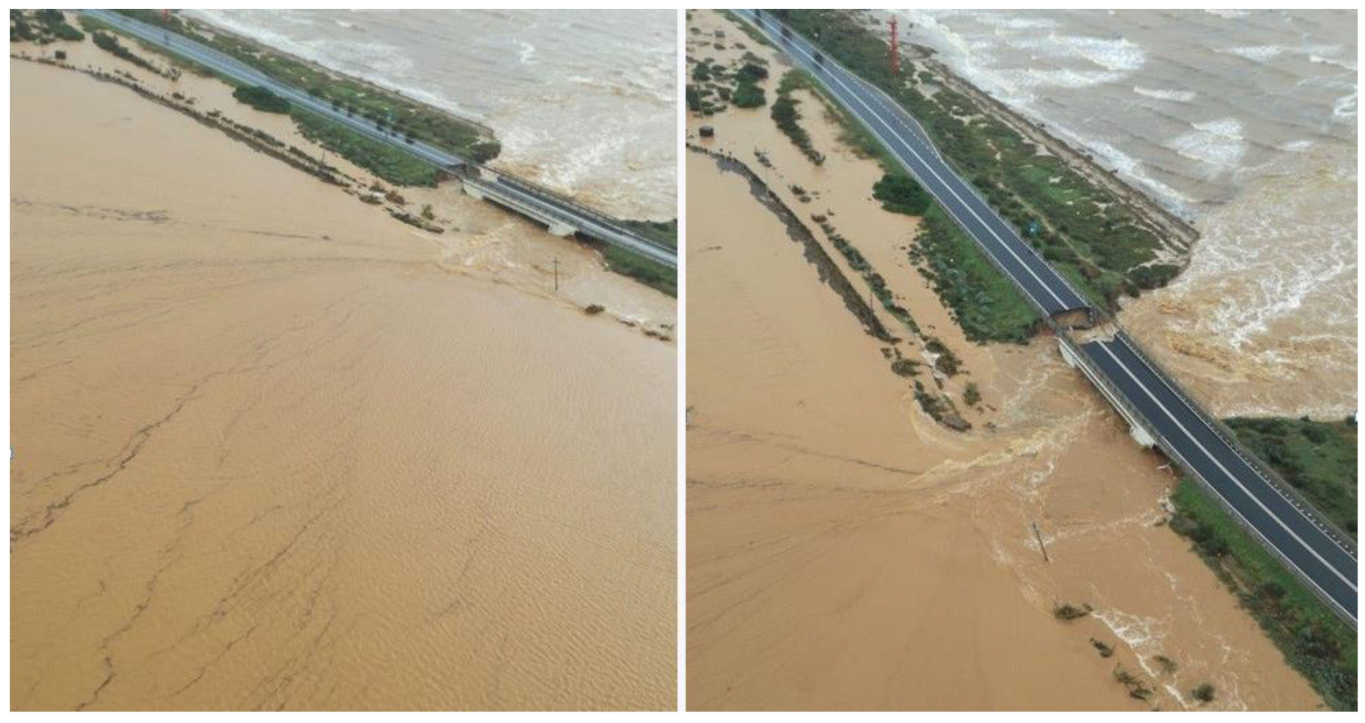
2.5. Barrier Breaching Events
Breaching is likely to become more common as a result of sea-level rise and barrier island flooding (Passeri et al., 2020). Storm hit the Southern Sardinia coast in October 2018 and resulted in widespread overwashing and numerous breaches. Figure 6 shows the main breaching at La Playa of 10 October which generate the collapse of the National Road SS195. It is to be noticed that SS195 is the emergency road to evacuate the population of Western Cagliari Municipality (Sulis et al., 2024).
Figure 6.
Barrier breaching at La Playa beach and collapse of SS 195 during the compound sea and lagoon flood of 10 October 2018.
Figure 6.
Barrier breaching at La Playa beach and collapse of SS 195 during the compound sea and lagoon flood of 10 October 2018.
Previous models generated from breaches of sand dikes focus on the expansion of the dune gap and find that breaches originate by head cutting and erosion of the barrier on the lagoon-side of the gap (Visser, 2001; Tuan et al., 2008). Basco and Shin (1999) found that surge level differences between ocean and bay, and the resulting water level gradients, regulate flow conditions and are an important predictor of barrier island breaching. Site-specific process-based models of overwashing flows include XBeach (Roelvink et al., 2009), but the accuracy of the barrier breach prediction is still questionable (Nienhuis et al., 2021).
Observations and modeling results of the event of October 2018 suggest that there is a particular emerging concern about compound water level extremes, when conditions are extreme in more than one water body. Engelstad et al., (2017) proposed a conceptual model postulating that “breach susceptibility” (Kraus et al., 2002) of a barrier beach is mainly related to the sea-back-barrierwater level gradient. Water levels may become elevated in the back-barrier with respect to the sea as the result of a wide range of processes (Goff et al., 2019), being runoff from upland precipitation the main forcing at S.Gilla lagoon. In extreme compound events, hydraulic gradient is able to drive a flow from the basin to the sea side, potentially leading to sediment deposition on the seaward side of a barrier island (Sherwood et al., 2014).
3. Results
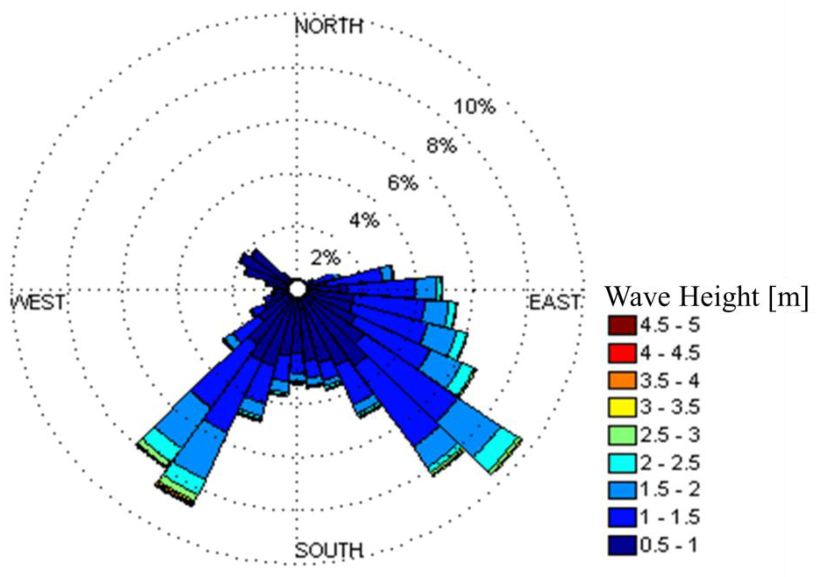
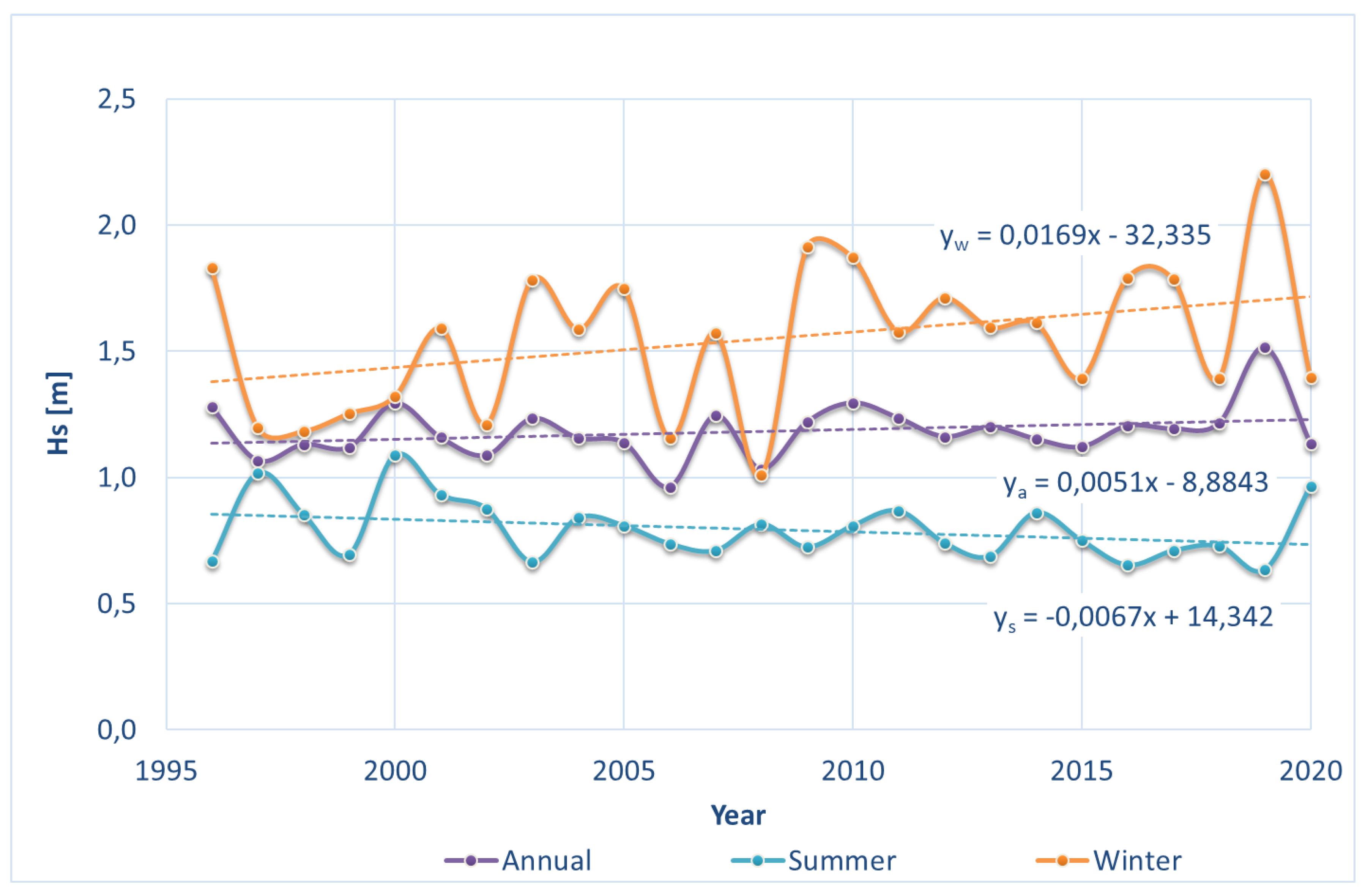
Here linear temporal trends are estimated using univariate linear regression models assuming low temporal correlation and Gaussian distributed errors. The regression slope coefficient is assumed as the trend. Different datasets were considered. Specifically to the wave dataset, analysis to the annual maximum wave heights shows a positive trend over the last decades along the ordinary least square equation (R2 = 0.92) (H(s,max) ) = 0.008 t – 12.245 being the rate equal to + 8 mm yr-1 (Figure 7). Increases in mean annual heights have been slightly smaller than maximum condition, the former with a rate equal to + 5 mm yr-1 (Figure 8). As expected, seasonal trend shows a strong positive trend in the winter dataset of both mean while mean and maximum wave heights have been decreasing during the summer.
Figure 7.
Conceptual model of barrier beach breaching.
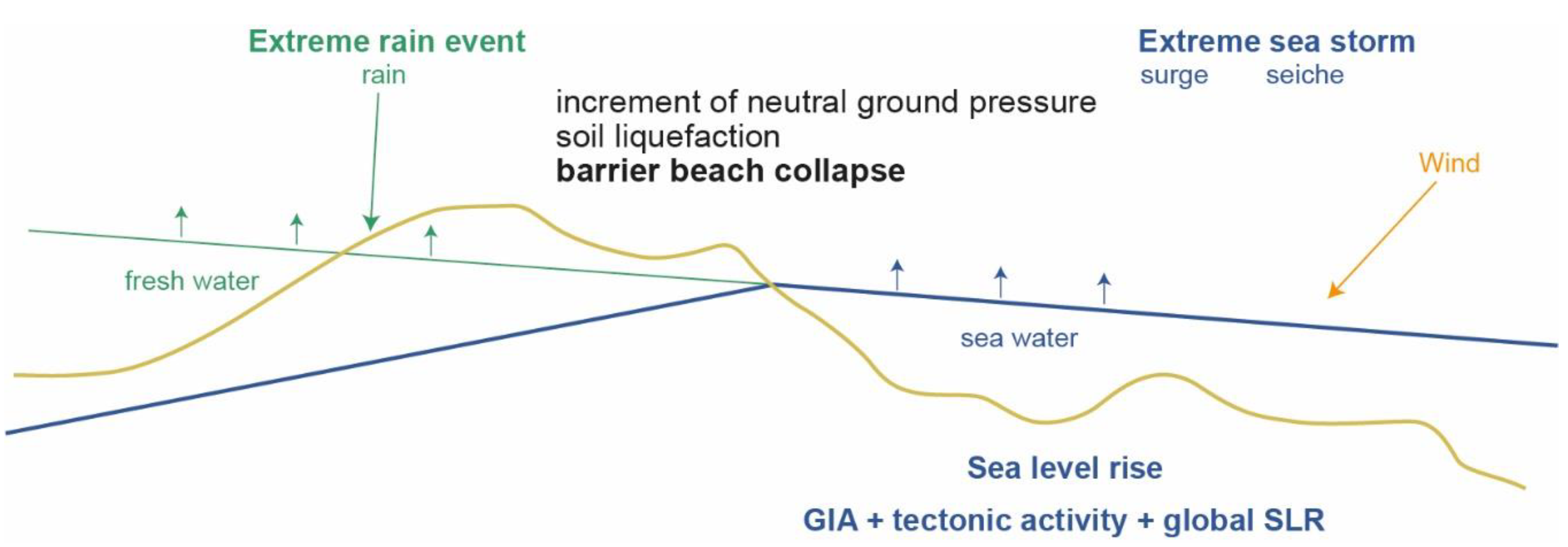
Figure 7.
Trend analysis of annual and seasonal maximum wave heights.
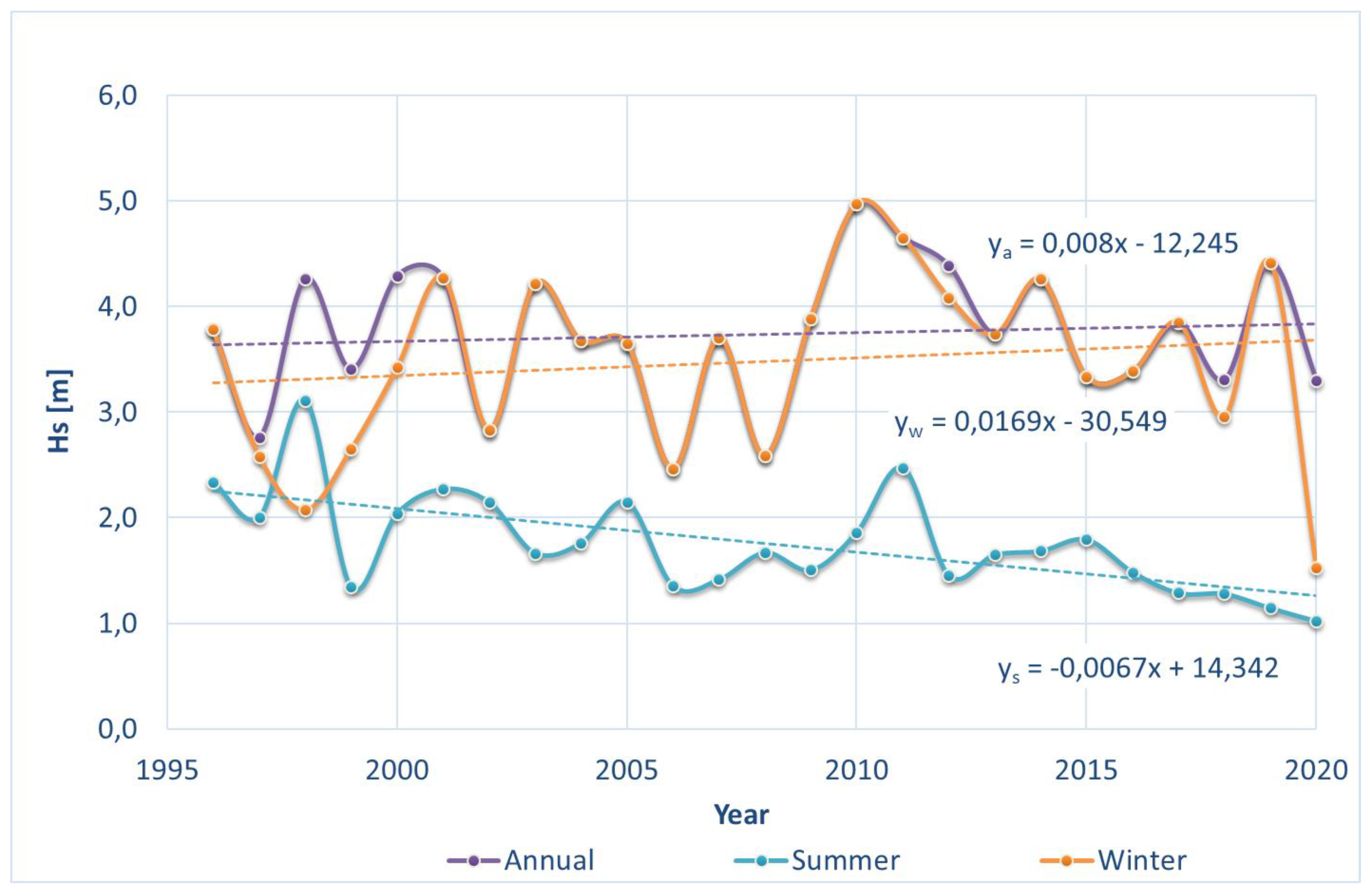
Figure 8.
Trend analysis of annual and seasonal mean wave heights.
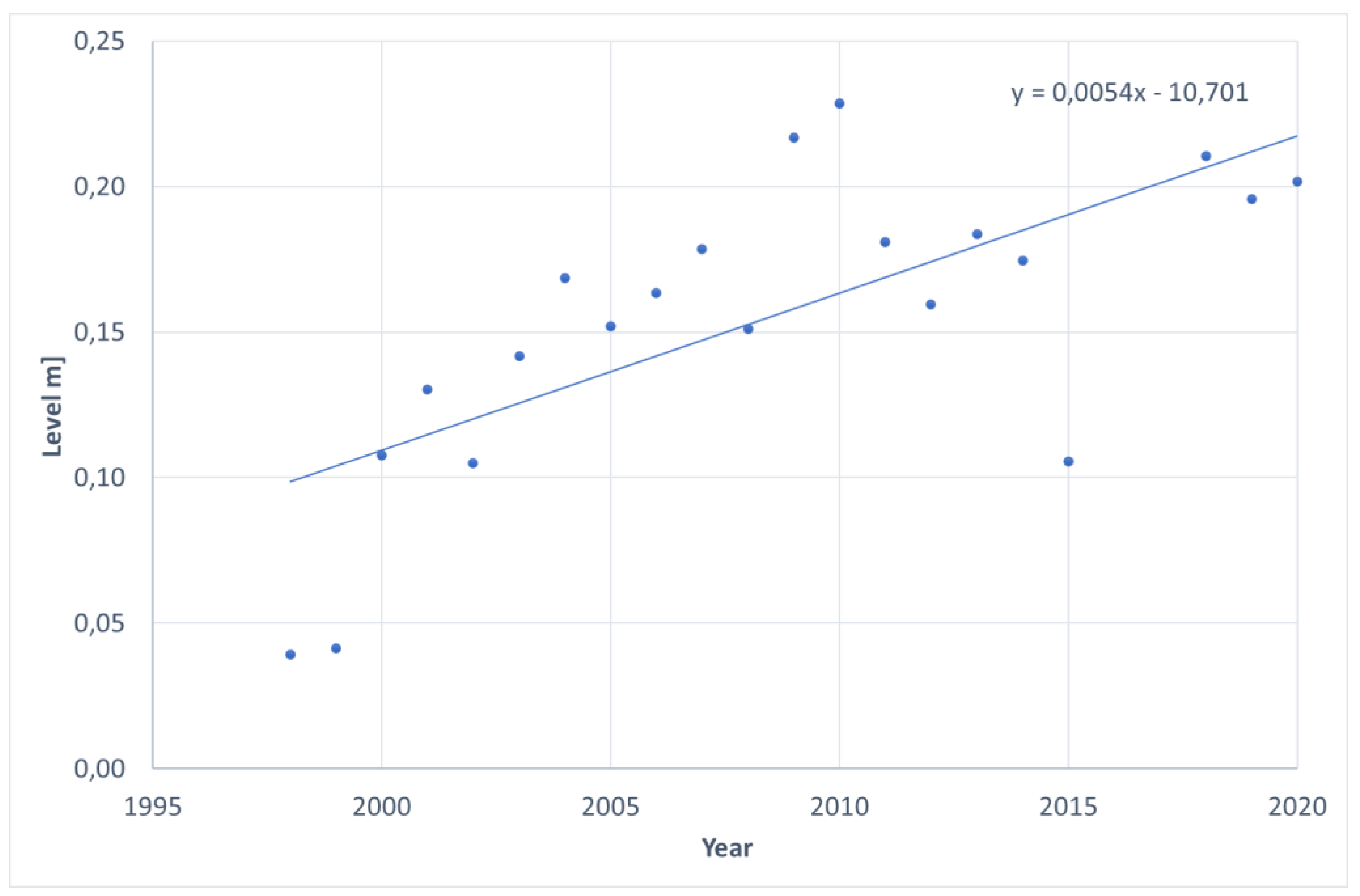
Global mean sea level will continue to rise during the 21st century. Under all RCP scenarios, the rate of sea level rise will very likely exceed the observed rate of 2.0 [1.7–2.3] mm yr-1 during 1971–2010, with the rate of rise for RCP8.5 during 2081–2100 of 8 to 16 mm yr-1(medium confidence). Based on 1999 – 2021 high-accuracy sea level dataset at Cagliari station of National Tidegauge Network (Rete Mareografica Nazionale – RMN), we estimate a rate of rise in the Gulf of Cagliari of 5.4 mm yr-1.
Figure 9.
Trend analysis of annual mean sea level in Cagliari RMN station.
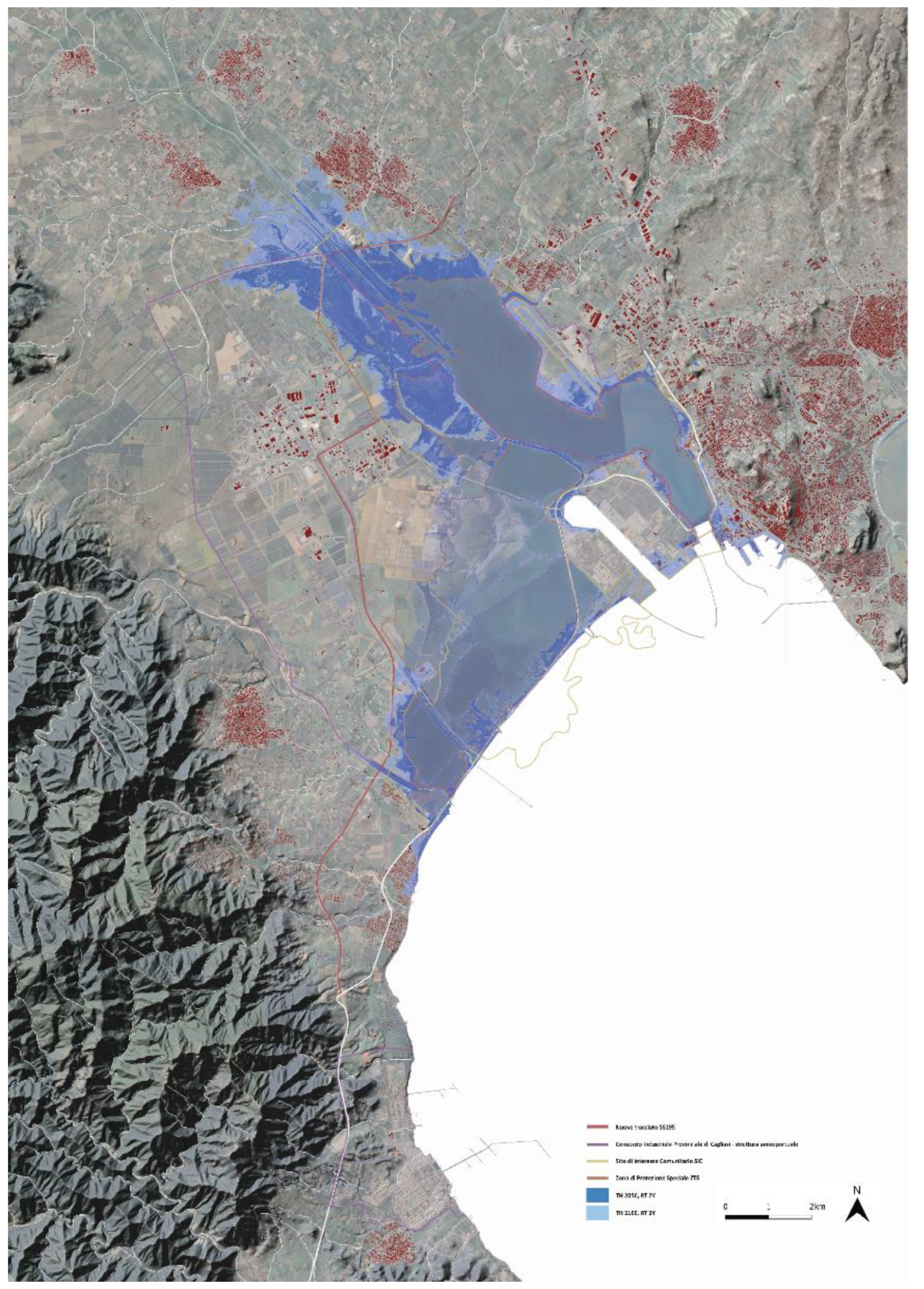
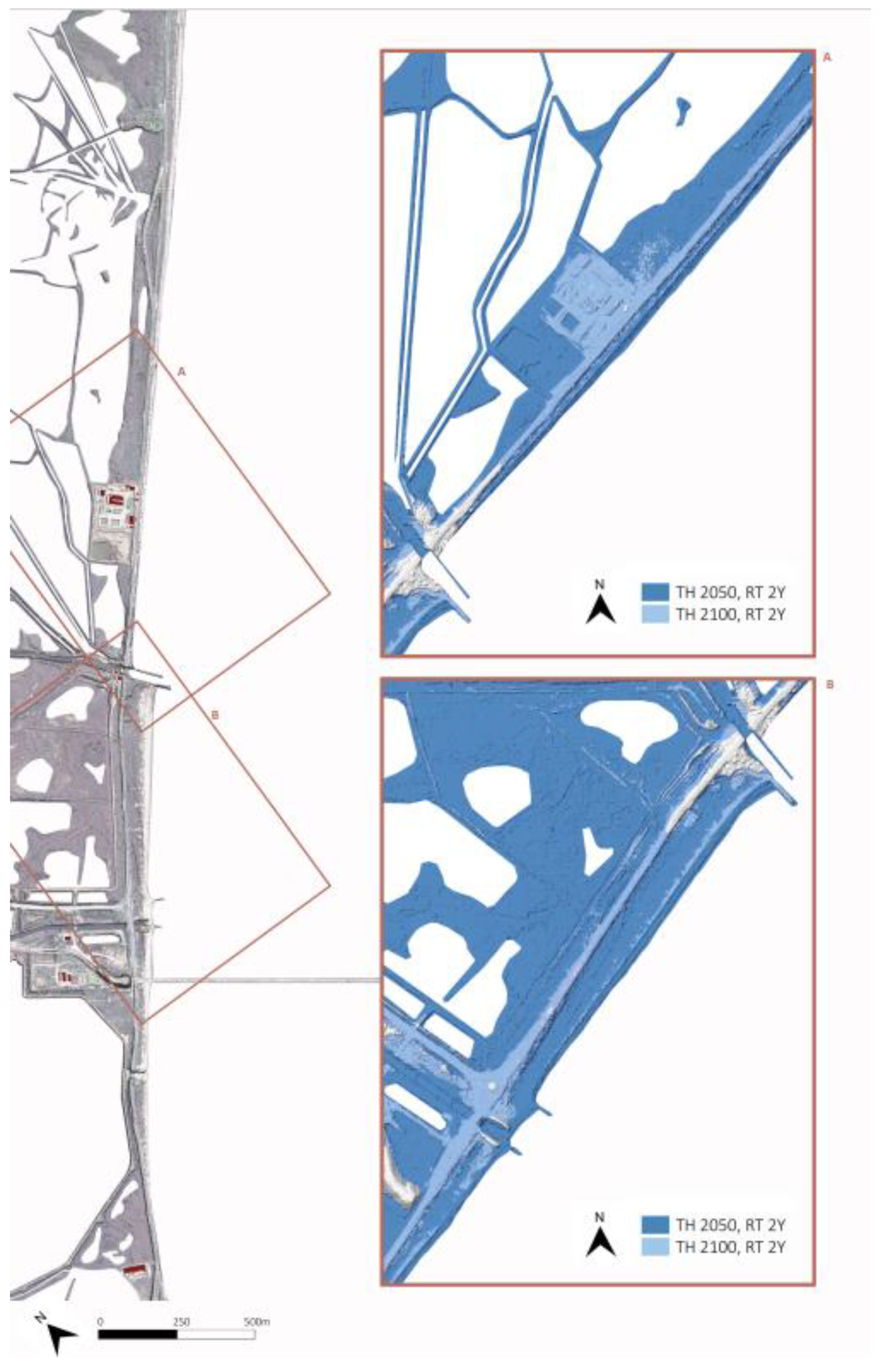
Extreme Wave Analysis (EWA) of the ESA – CCI wave dataset was performed with a Gumbel distribution with the method of moments to estimate the best fitting distribution. A two-year return time event was selected as representive of frequent, low magnitude events that could affect the system vulnerability at different spatial scales. The propagation of the offshore wave data from the mouth of the Gulf of Cagliari to the nearshore area have been simulated with MIKE 21 Spectral Wave (SW) model, one of the state-of-the art numerical modelling tools for studying spectral wind-wave modelling (Sulis & Asproni, 2015). The obtained conditions in the extraction point of that field corresponding to the wave breaking area were used in the Stockdon empirical wave run-up model. Figure 10 shows the flooded area in two selected scenarios, namely at 2050 and 2010. At the territorial scale, the comparison of the two flooded area shows a moderate increase equal to 23% when time horizon grows. At local scale, moving from 2050 to 2100 in the La Playa barrier beach shows how the entire beach will be flooded including a major part of the SS195 (Figure 11). This flood ordinary scenario foresees a flattening of the submerged morphologies leading to a morphological simplification, dismantling the geomorphological characteristics of the lagoon-estuary and triggering the process of marine embayment.
4. Discussion
Modelling results show the morphological response of the barrier beach at La Playa. In conditions of complete naturalness of the regime of tributaries of water, with a considerable amount of sediments introduced into the system sufficient to compensate for the morphological arrangement due to SLR, the systems of a natural barrier island could counteract the submersion through a morphological change of elevation (roll-over) or be overtaken by rapid submersion, as occurred during the Holocene in the northern Adriatic (Fontolan et al 2012), but also in the Gulf of Oristano (De Falco et al 2017).
On the contrary, in the current conditions of the urban lagoon barrier system of the Cagliari plain it is stiffened by maritime works surmounted by roads with artificially channeled river mouths and solid transport slowed down by works along the riverbeds. There is therefore an opposite reaction to SLR, due to the lack of morphological degree of freedom. The possible beach adaptation response, according to the well-known rule of Bruun (Brun 1962), due to the lack or scarcity of sediments, erosion phenomena will prevail over stability and deposition, creating a littoral system in disequilibrium with sediment-starved coastal strands.
Based on local temporal trends in Hs (8 mm yr-1) and sea level (SLR of 5.4 mm yr-1), new adaptation strategies should be adopted in the design of coastal protection to reduce that disequilibrium trend.
As an exemple, to maintain the risks of structural damage at the rubble-mound breakwaters of the commercial harbor in Cagliari, the weight of an individual armor unit will increase by 150% and the crest height will have to be raised of 20%. Increase in breakwater section for the 2100s SLR scenario will be of 20% with an increased cost of 2 M€.
In a wider perspective, the analysis of the above model results is used to produce 'questions of interest' (Derbyshire, Wright 2017) rathen than 'exact' predictions of the fundamental changes that will occur in the future. Here, the aim is to produce knowledge experiences/courses which could support spatial planning activities for this environmental region. Model results, both numerical and analytical, highlight the main trends and indications of change of the environment structure. For this reason, models help to strengthen 'exploratory scenarios', i.e. scenarios that 'describe, on the basis of a current situation and dominant trends, a series of events that necessarily lead to a possible future' (Julien et al., 1975). Exploratory scenarios, being knowledge tools that envisage future environments, enable informed decision-making and prompt a capacity for future action. These emphasizes the processes of adaptation to climate change and the possibility of accommodating possible extreme events without trauma.
Among the various methods of future studies, this research particularly refers to . Addressing public policies to future visions can therefore open Santa Gilla lagoon to a multiplicity of possible scenarios (the 'futures'), supported by rigorous methods and techniques.
In the 'scenario planning method' (SPM, Godet and Durance 2011), the used models and techniques have a dual nature: a descriptive dimension that explores the environmental context of the lagoon in its internal dynamics and an instrumental dimension that questions the long-term static and dynamic impacts, the former being linked to the global level studies of the IPCC and to the specificities of the Mediterranean area and the latter showing the static impacts of sea level changes and dynamic impacts at a local level.
The SPM allows us to explore under which conditions and where the vulnerabilities of the coastal system become more significant. The 2050 scenario is used as a projected scenario in line with the current state of the lagoon. The continuity refers to the design approaches: additional sea and lagoon defense works will be required to protect the urban banks of the lagoon and the coastal strip infrastructures. To offset the system's vulnerability in this scenario, further reinforcement of the banks is needed: this makes stable the current configuration and urban structure.
This artificial reinforcement/stiffening generates local vulnerability: that because of the interference between the perspectives outlined in the models and the current municipal plans for special area (port, airport, industrial areas), for transport and infrastructure plans.
The system is also vulnerable locally as a result of the 'coastal squeeze'. It describes the process in which sea-level rise and other factors and sea storm push coastal habitats towards land. Coastal defences create a static, artificial margin that squeezes the habitats of the system into a restricted area due to the erosion process (Doody 2013). The adaptation process to SLR, or extreme weather and climate events, is thus obstructed: the movement of habitats towards land to maintain their relative position to wave and tidal forces is effectively denied. In this system, the La Playa beach is a coastal space 'squeezed' between the coastline and the coastal infrastructure (Sulis et al., 2023): then the processes of natural adaptation of the Santa Gilla ecosystem to extreme events are limited by the pressure of urban infrastructure. This scenario enforces a constant approach to mitigation and emergency. Rigid structures within the area of direct wave influence, such as the existing coastal road 195, accentuate local vulnerability to coastal erosion phenomena and produce vulnerabilities at a territorial scale. SS195 is a strategic infrastructural connection between the capital city, Cagliari, and the south-western coast of the island. Moreover, it attracts daily a multiplicity of people and goods movements. The absence of connectivity puts residents of a vast urban area at risk of losing access to critical services that are vital for city living (hospitals, transport infrastructures, extra-local urban services, schools). It also exposes them to the loss of safe travel conditions in relation to the greater fragility of the coastal strip where the SS 195 settled.
Figure 12.
Mosaic of plans (from https://www.urbismap.com/).
Figure 12.
Mosaic of plans (from https://www.urbismap.com/).
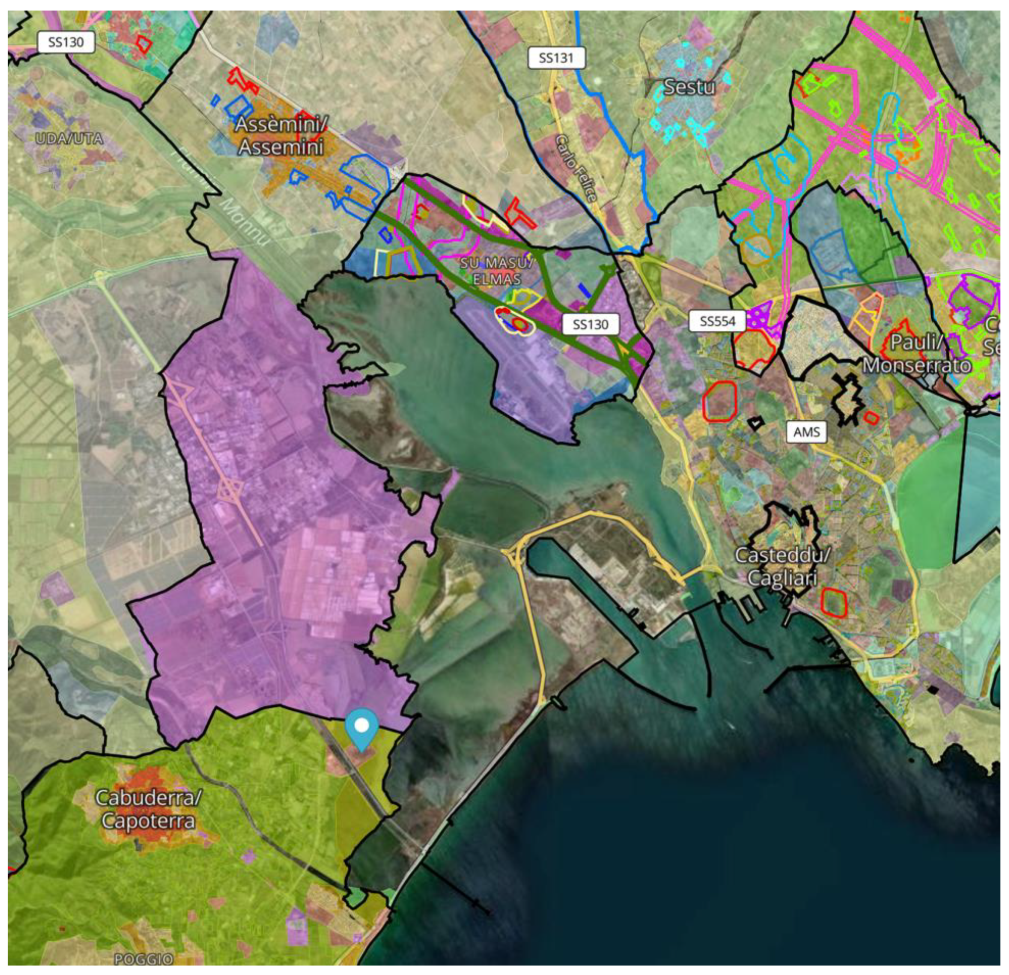
In the 2100 scenario, the flattening of the submerged morphologies triggers the process of marine embayment. In fact, the spatial layout and system ecological balance will change. The scenario draws attention to an alternative image and new environmental representations of this urban region. Indeed, a new internal gulf will be created and the present settlements (built-up areas, industrial areas, service centres, etc.) close to the new shoreline will face new forcing and dynamics. This spatial representation imposes new visions for future and different land use. It prompts a review of the planning hypotheses of the municipalities located on the banks of the lagoon, and, at the same time, offers unprecedented possibilities for city regeneration processes. It also requires infrastructures to change in perspective for the new development. In the 2100 scenario, the spatial organization of the new inner gulf of the metropolitan system confines the Canal Port area into an island. It will be anchored to the mainland by road infrastructure. To reduce its local vulnerability and thus maintain the planned and currently planned facilities (service and research centers, new ro-ro terminal, nautical and shipbuilding hub), new coastal defence infrastructures will be necessary. The same problem will arise for the airport area or the industrial areas on the banks of the lagoon.
Figure 12.
Mosaic of plans (from https://www.urbismap.com/).
Figure 12.
Mosaic of plans (from https://www.urbismap.com/).
5. Conclusions
The results of this work point to two very relevant data for the future layout of the santa Gilla lagoon areas: increases in annual maximum heights greater than average conditions with a rate of +8 mm yr-1; an increase in the global average sea level is also expected, and this work has estimated a rate of rise in the Gulf of Cagliari of 5.4 mm yr-1.
These data allow us to identify different vulnerabilities: we have represented them through two scenarios at different time horizons. The results obtained impose different adaptation strategies which affect the planning and design approaches of this area. These scenarios can support decision-making processes that have very different visions of the future: the alternative strategies identify future urban planning actions in relation to the resulting spatial organisation. The second scenario appears utopian: however, if considered as a backdrop for spatial planning policies, it is the one which guarantees highest freedom degrees for the system, cancels out current vulnerabilities, avoids perpetuating habitat exploitation and thus the coastal squeeze process.
Scenario planning, when supported by formal models such as those elaborated in this research, in addition to forecasting hypotheses, thus creates the prerequisites to share convenient knowledge. It can open public discussion on the lagoon and support the involvement of local actors and, more generally, of the communities of metropolitan area. The exploratory scenarios illustrated in this research can therefore become decision support scenarios for spatial and strategic planning. In the territorial context of Santa Gilla they can locally introduce climate change adaptation actions. They can also produce strategic choices for future urban transformations. Indeed this this exploratory scenarios are based on quantitative models to deal with complexity and uncertainty. Indeed, the scenario planning process generates continuous learning processes (Van der Heijden 1996). It creates the basis for a different way of thinking about the future of this important environmental and human ecosystem.
References
- Anderson, T.; Hawkinsb, E.; Jonesc, P.D. CO2, the greenhouse effect and global warming: from the pioneering work of Arrhenius and Callendar to today’s Earth System Models. ScienceDirect Endeavour 2016, 40, 3. [Google Scholar] [CrossRef] [PubMed]
- Antonioli, F.; Lo Presti, V.; Anzidei, M.; Deiana, G.; De Sabata, E.; Ferranti, L.; Furlani, S.; Mastronuzzi, G.; Orrù, P.; Pagliarulo, R.; Rovere, A.; Sannino, G.; Sansò, P.; Scicchitano, G.; Spampinato, C.R.; Vacchi, M.; Vecchio, A. (2015) Tidal notches in the Mediterranean Sea. Quat Sci Rev 2015, 119, 1–19. [Google Scholar] [CrossRef]
- Antonioli, F.; Anzidei, M.; Amorosi, A.; Lo Presti, V.; Mastronuzzi, G.; Deiana, G.; De Falco, G.; Fontolan, G.; Fontana, A.; Lisco, S.; Marsico, A.; Moretti, M.; Orru, P.; Sannino, G.M.; Serpelloni, E.; Vecchio, A. Sea-level rise and potential drowning of the Italian coastal plains: flooding risk scenarios for 2100. Quat Sci Rev 2017, 158, 29–43. [Google Scholar] [CrossRef]
- Aucelli, P.P.C.; Di Paola, G.; Incontri, P.; Rizzo, A.; Vilardo, G.; Benassai, G.; Buonocore, B.; Pappone, G. Coastal inundation risk assessment due to subsidence and sea level rise in a Mediterranean alluvial plain (Volturno coastal plain—Southern Italy). Estuar. Coast. Shelf Sci. 2017, 198, 597–609. [Google Scholar] [CrossRef]
- Aucelli, P.P.C.; Di Paola, G.; Rizzo, A.; Rosskopf, C.M. Present day and future scenarios of coastal erosion and flooding processes along the Italian Adriatic coast: The case of Molise region. Environ. Earth Sci. 2018, 77, 371. [Google Scholar] [CrossRef]
- Auriemma, R.; Solinas, E. Archaeological sites as sea level change markers: a review. Quaternary International JQI1 2009, 206, 134–146. [Google Scholar] [CrossRef]
- Bernardini, P.; Santoni, V.; Solinas, E. Il Mistero di Santa Gilla. Archeologia Viva 1993, 37, 26–40. [Google Scholar]
- Bonaldo, D.; Bucchignani, E.; Pomaro, A.; Ricchi, A.; Sclavo, M.; Carniel, S. Wind waves in the Adriatic Sea under a severe climate change scenario and implications for the coasts. Int J Climatol. 2020, 40, 5389–5406. [Google Scholar] [CrossRef]
- Bonaldo, D.; Antonioli, F.; Archetti, R.; Bezzi, A.; Correggiari, A.; Davolio, S.; Falco, G.D.; Fantini, M. Integrating Multidisciplinary instruments for assessing coastal vulnerability to erosion and sea level rise: lessons and challenges from the adriatic sea, Italy. Journal of Coastal Conservation 2018, 23, 19–37. [Google Scholar] [CrossRef]
- Bruun, P. Sea-level rise as a cause of shore erosion. Am. Soc. Civ. Eng. Proc. J. Waterways Harbours Divisione 1962, 88, 117–130. [Google Scholar] [CrossRef]
- Church, J.A.; Clark, P.U.; Cazenave, A.; Gregory, J.M.; Jevrejeva, S.; Levermann, A.; Merrifield, M.A.; Milne, G.A.; Nerem, R.S.; Nunn, P.D.; et al. Sea-Level Rise by 2100. Science 2013, 342, 1445. [Google Scholar] [CrossRef] [PubMed]
- Day, J.; Ibáñez, C.; Scarton, F.; Pont, D.; Hensel, P.; Day, J.; Lane, R. Sustainabilityof mediterranean deltaic and lagoon wetlands with sea-level rise: the importance of river input. Estuaries and Coasts 2011, 34, 483e493. [Google Scholar] [CrossRef]
- Darmaraki S, Somot S, Sevault F, Nabat P, Cabos W, Cavicchia L, Djurdjevic V, Li L, Sannino G, Sein D (2019) Future evolution of marine heat waves in the Mediterranean sea. Clim Dyn 2019, 53, 1371–1392. [CrossRef]
- De Falco, G.; Antonioli, F.; Fontolan, G.; Lo Presti, V. Simeone S.; Tonielli R. Early cementation and accommodation space dictate the evolution of an overstepping barrier system during the Holocene. Marine Geology 2015, 369, 52–56. [Google Scholar] [CrossRef]
- Deiana, G.; Antonioli, F.; Moretti, L.; Orrù, P.E.; Randazzo, G.; Lo Presti, V. MIS 5.5 Highstand and Future Sea Level Flooding at 2100 and 2300 in Tectonically Stable Areas of Central Mediterranean Sea: Sardinia and the Pontina Plain (Southern Latium). Italy. Water 2021, 13, 2597. [Google Scholar] [CrossRef]
- Devoti, Roberto, Nicola D’Agostino, Enrico Serpelloni, Grazia Pietrantonio, Federica Riguzzi, Antonio Avallone, Adriano Cavaliere, et al. “A Combined Velocity Field of the Mediterranean Region,” 2017. [CrossRef]
- El-Sayed, M.K. Beachrock cementation in Alexandria, Egypt. Marine Geology 1988, 80, 29–35. [Google Scholar] [CrossRef]
- Ferranti, L.; Antonioli, F.; Amorosi, A.; Dai Prà, G.; Mastronuzzi, G.; Mauz, B.; Monaco, C.; Orrù, P.; Pappalardo, M.; Radtke, U.; Renda, P.; Romano, P.; Sansò, P.; Verrubbi, V. Elevation of the last interglacial highstand in Italy: a benchmark of coastal tectonics. Quat 2006. [Google Scholar]
- Fontolan, G.; Pillon, S.; Bezzi, A.; Villalta, R.; Lipizer, M.; Triches, A.; Daietti, A. Human impact and the historical transformation of saltmarshes in the Marano and Grado lagoon, northern Adriatic sea. Estuar. Coast. Shelf Sci. 2012, 113, 41e56. [Google Scholar] [CrossRef]
- Hegerl, G.C.; Zweirs, F. Use of models in detection & attribution of climate change. WIREs Climate Change. 2011, 2, 570–591. [Google Scholar]
- Hegerl, G.C.; Hasselmann, K.; Santer, B.G. Detecting Greenhouse-Gas-Induced Climate Change with an Optimal Fingerprint Method. Journal of Climate 1996, 9, 2281–2306. [Google Scholar] [CrossRef]
- Hasselmann, K.; Kovalevsky, D.V. Simulating animal spirits in actor-based environmental models. Environmental Modelling and Software, 2013, 44, pp. 10–24. [Google Scholar] [CrossRef]
- Kawamura, K.; Nakazawa, T.; Aoki, S.; Sugawara, S.; Fujii, Y.; Watanabe, O. Atmospheric CO2 variations over the last three glacial-interglacial climatic cycles deduced from the Dome Fuji deep ice core, Antarctica using a wet extraction technique. Tellus 2003, 55B, 126–137. [Google Scholar] [CrossRef]
- Kemp, A.C.; Horton, B.P.; Donnelly, J.P.; Mann, M.E.; Vermeer, M.; Rahmstorf, S. Climate related sea-level variations over the past two millennia. Proc. Natl. Acad. Sci. USA 2011, 108, 11017–11022. [Google Scholar] [CrossRef] [PubMed]
- Kim, S.J.; Crowley, T.J.; Stössel, A. Local Orbital Forcing of Antarctic Climate Change During the Last Interglacial. Science 1998, 280, 728–730. [Google Scholar] [CrossRef] [PubMed]
- Lambeck, K.; Antonioli, F.; Anzidei, M.; Ferranti, L.; Leoni, G.; Scicchitano, G.; Silenzi, S. Sea level change along italian coast during Holocene and a projection for the future. Quat. Int. 2011, 232, 250–257. [Google Scholar] [CrossRef]
- Landais, A.; Dreyfus, G.; Capron, E.; Masson-Delmotte, V.; Sanchez-Gon˜, M.F.; Desprat, S.; Hoffmann, G.; Jouzel, J.; Leuenberger, M.; Johnsen, S. What drives the millennial and orbital variations of d18Oatm? Quaternary Science Reviews 2010, 29, 235–246. [Google Scholar] [CrossRef]
- Landais, A.; Chappellaz, J.; Delmotte, M.; Jouzel, J.; Blunier, T.; Bourg, C.; Caillon, C.; Cherrier, S.; Malaize´, B.; Masson-Delmotte, V.; Raynaud, D.; Schwander, J.; Steffensen, J.P. A tentative reconstruction of the last interglacial and glacial inception in Greenland based on new gas measurements in the Greenland Ice Core Project (GRIP) ice core. J. Geophys. Res. 2003, 108, D18. [Google Scholar] [CrossRef]
- Lionello, P.; Conte, D.; Marzo, L. and Scarascia, L. The contrasting effect of increasing mean sea level and decreasing storminess on the maximum water level during storms along the coast of the Mediterranean Sea in the mid 21st century. Global and Planetary Change 2017, 151, 80–91. [Google Scholar] [CrossRef]
- Marsico, A.; Lisco, S.; Presti, V.L.; Antonioli, F.; Amorosi, A.; Anzidei, M.; Deiana, G.; Falco, G.D.; Fontana, A.; Fontolan, G.; et al. Flooding scenario for four Italian coastal plains using three relative sea level rise models. J. Maps 2017, 13, 961–967. [Google Scholar] [CrossRef]
- Mastronuzzi, G.; Palmentola, G.; Sansò, P. Some Theoretic aspects of rocky coast dynamics. Boll. Ocean. Teor. Appl. 1992, 10, 109–115. [Google Scholar]
- Orrù, P.E.; Antonioli, F.; Hearty, P.J.; Radtke, U. Chronostratigraphic confirmation of MIS 5 age of a baymouth bar at Is Arenas (Cagliari, Italy). Quat. Int. 2011, 232, 169e178. [Google Scholar] [CrossRef]
- Orrù, P.E.; Antonioli, F.; Lambeck, K.; Verrubbi, V. ; 2004. Holocene Sea-level Change in the Cagliari Coastal Plain. Quaternaria nova, VIII, South Sardinia, Italy, pp. 193e210.
- Rahmstorf, S. A Semi-Empirical Approach to Projecting Future Sea-Level Rise. Science 2007, 315, 368–370. [Google Scholar] [CrossRef] [PubMed]
- Reale, M.; Narvaez, W.; Cavicchia, L.; Conte, D.; Coppola, E.; Flaounas, E.; Giorgi, F.; Gualdi, S.; Hochman, A. ,Li L.; Lionell P.; Podrascanin Z.; Salon S.; Sanchez-Gomez E.; Scoccimarro E, Sein D.V.; Somot S.. Future projections of Mediterranean cyclone characteristics using the Med-CORDEX ensemble of coupled regional climate system models. Climate Dynamics, 2021. [CrossRef]
- Reed, D.J. The response of coastal marshes to sea-level rise: survival orsubmergence. Earth Surface Processes and Landforms 1995, 20, 39e48. [Google Scholar] [CrossRef]
- Rovere, A.; Raymo, M.E.; Vacchi, M.; Lorscheid, T.; Stocchi, P.; Gomez-Pujol, L.; Harris, D.L.; Casella, E.
- O'Leary, M.J.; Hearty, P.J. The analysis of Last Interglacial (MIS 5e) relative sea-level indicators: reconstructing sea-level in a warmer world. Earth Sci. Rev. 2016, 159, 404e427. [Google Scholar]
- Solinas, E.; Orrù, P. 2006. Santa Gilla: spiagge sommerse e frequentazione di epoca punica. In: Giannattasio B.M. (Ed.), Aequora, pontos, jam, mare… Mare, uomini e merci nel Mediterraneo Antico. Atti del Convegno Internazionale (Genova, 9-10 dicembre 2004), Firenze, pp. 249–252.
- Sulis, R.; Cozza, A. Annis Extreme wave analysis methods in the gulf of Cagliari (South Sardinia, Italy). Ocean & Coastal Management 2017, 140, 79–87. [Google Scholar] [CrossRef]
- Sulis, S. Asproni, (2015). Modelling storm-induced beach evolution at La Playa beach, Sardinia, IT. Proceedings of SCACR2015. 28 September – 1 October, 2015, Florence, Italy. 2015. [Google Scholar]
- Stocchi, P.; Spada, G. Glacio and hydro-isostasy in the Mediterranean Sea: Clark’s zones and role of remote ice sheets. Ann. Geophys. 2007, 50, 741–761. [Google Scholar] [CrossRef]
- Sunamura (1992) - Geographology of Rocky Coasts. John Wiley & Sons. Chichester, New York, 300 pp. SPADA G.
- WTimmermans, C.P. Gommenginger, G. Dodet, J.-R. Bidlot Global Wave Height Trends and Variability from New Multimission Satellite Altimeter Products, Reanalyses, and Wave Buoys. Geophysical Research Letters 2000, 47. [Google Scholar] [CrossRef]
- Vermeer, M.; Rahmstorf, S. Global sea level linked to global temperature. Proc. Natl. Acad. Sci. USA 2009, 106, 21527–21532. [Google Scholar] [CrossRef] [PubMed]
- Ghanavati, M.; Young, I.; Kirezci, E.; Ranasinghe, R.; Duong, T.M.; Luijendijk, A.P. An assessment of whether long-term global changes in waves and storm surges have impacted global coastlines. Sci Rep 2023, 13, 11549. [Google Scholar] [CrossRef] [PubMed]
Figure 1.
Geographic location of the study area: a) Sardinia Island within the Mediterranean Sea; b) Cagliari Gulf on the SW side of Sardinia; c) Structural sketch map of the Mediterranean area. Red lines mark thrust fronts; (after Carminati and Doglioni, 2008 mod.).
Figure 1.
Geographic location of the study area: a) Sardinia Island within the Mediterranean Sea; b) Cagliari Gulf on the SW side of Sardinia; c) Structural sketch map of the Mediterranean area. Red lines mark thrust fronts; (after Carminati and Doglioni, 2008 mod.).
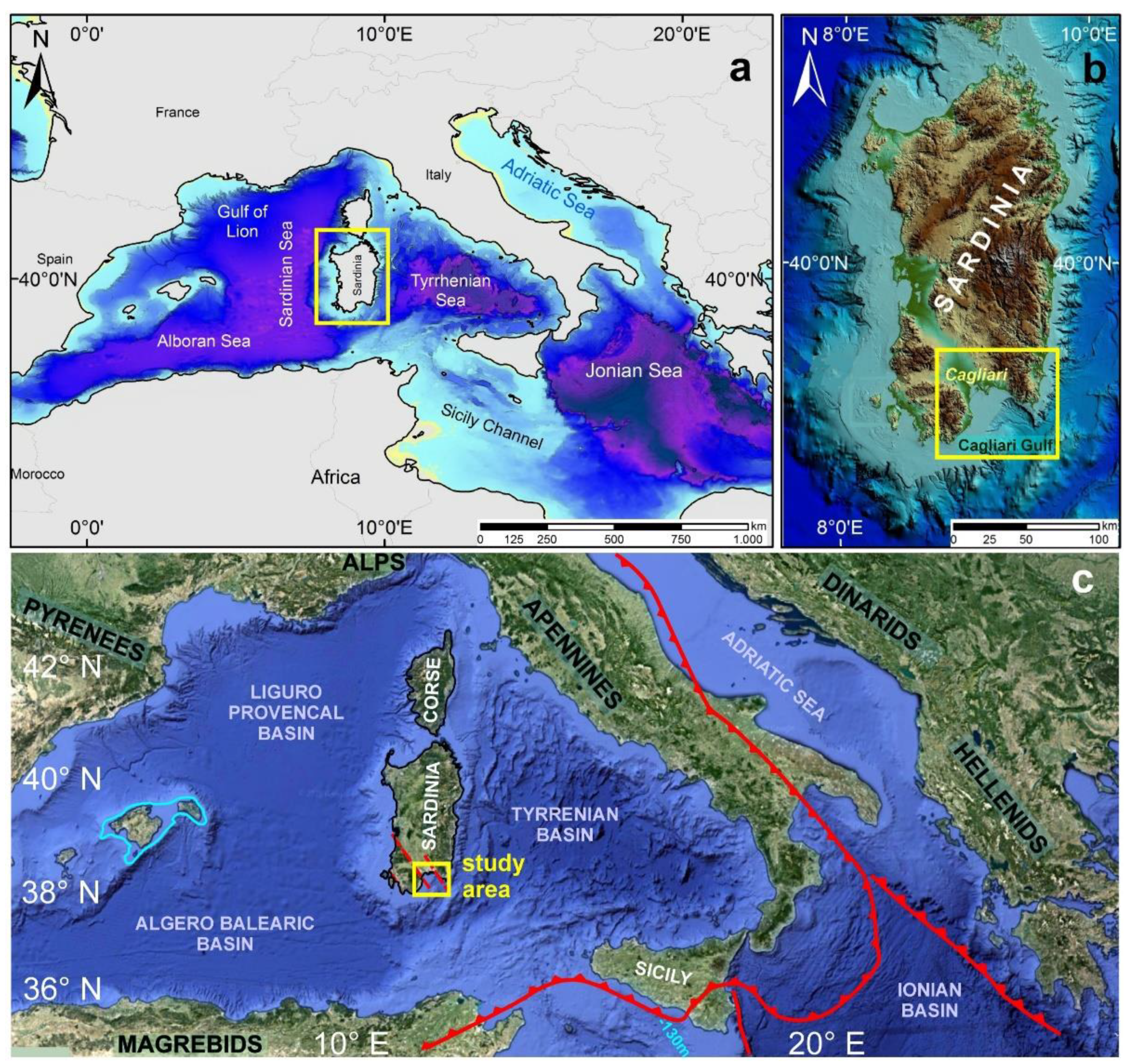
Figure 2.
Geological section at the mouth of the Santa Gilla lagoon; three stratigraphic surveys provide a breakdown of filled Holocene (Orrù et al., 2004) of the deep valley of the River Mannu paleo - Cixerri (MIS 2 - Upper Pleistocene) during the Holocene eustatic rise. Legend: 1) sandstone and marl sandstones (Miocene); 2) deltaic complex in silt and sandy silt with clay and sand with Ostrea sp. in lenses (Middle Pleistocene); 3) polygenic gravels in clay matrix (middle Pleistocene); 4a) weakly cemented sands and silty sands yellowish to bioturbation and Strombus bubonius (=Persististrombus latus) (MIS 5 - Upper Pleistocene); 4b) sandstones and microconglomerate with Cladocora coespitosa - 149 ± 10 kyr BP (Ulzega & Hearty, 1986) (MIS 5e - Upper Pleistocene); 5) polygenic gravel with sandy matrix (MIS 2 - Upper Pleistocene); 6a) deltaic silt and sandy silt paralic (Yunger Dryas); 6b) littoral sandy silt and silty sands with interbedded peat in Posidonia oceanica; 6c) alternating littoral fine sands and silty sand lagoon; 6d) succession of erosional surfaces and filled with sandy silt and sand bioclastic lagoon; 6e) for marine-coastal sands with interbedded thin peaty Posidonia oceanica; 6f) lagoonal organic sands and silts; 7) silt and organic and anthropogenic deposits.
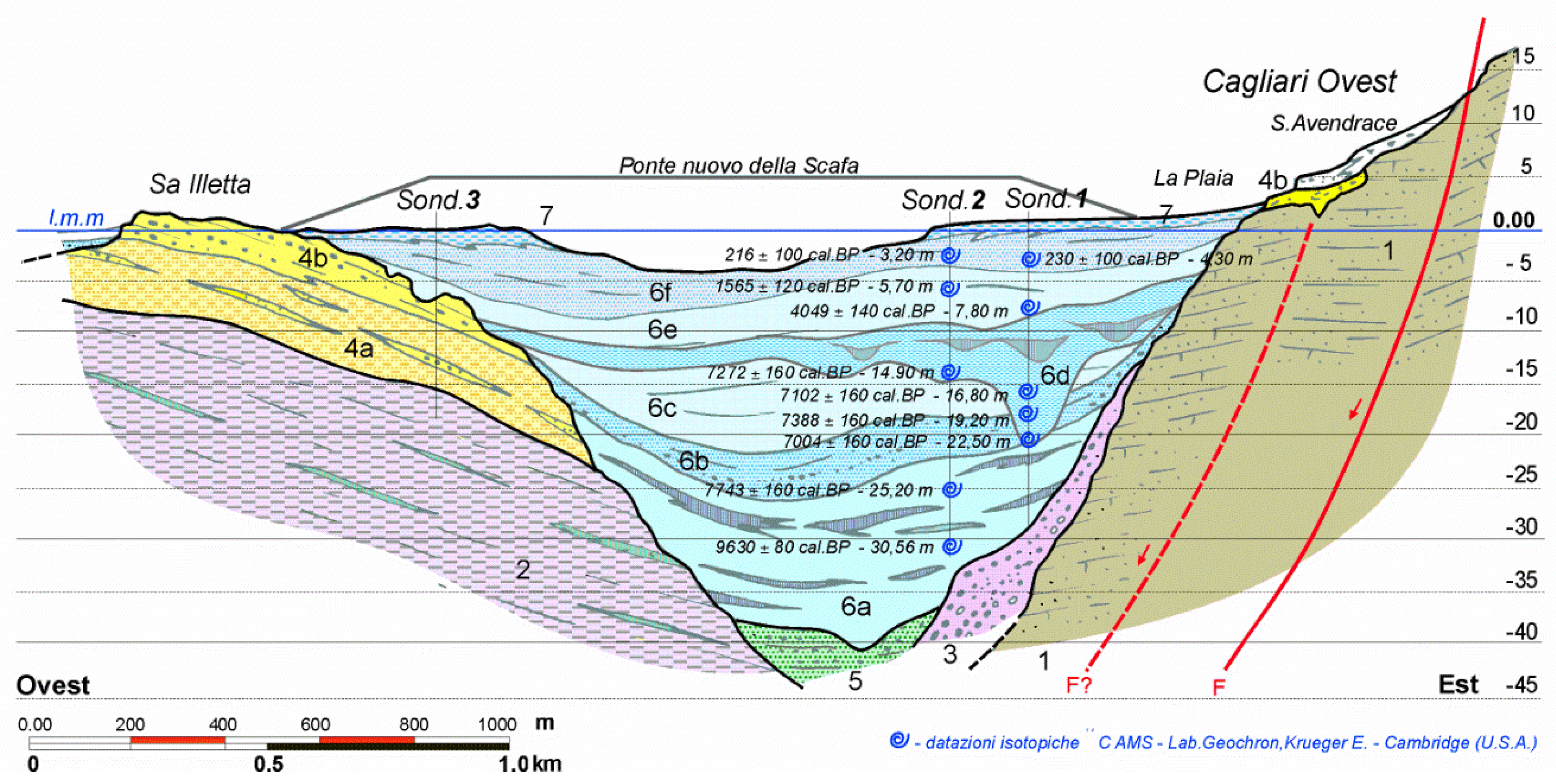
Figure 10.
Sea coastal flooding in the 2050 and 2100 scenarios for a 2-year return time event. Territorial scale.
Figure 10.
Sea coastal flooding in the 2050 and 2100 scenarios for a 2-year return time event. Territorial scale.
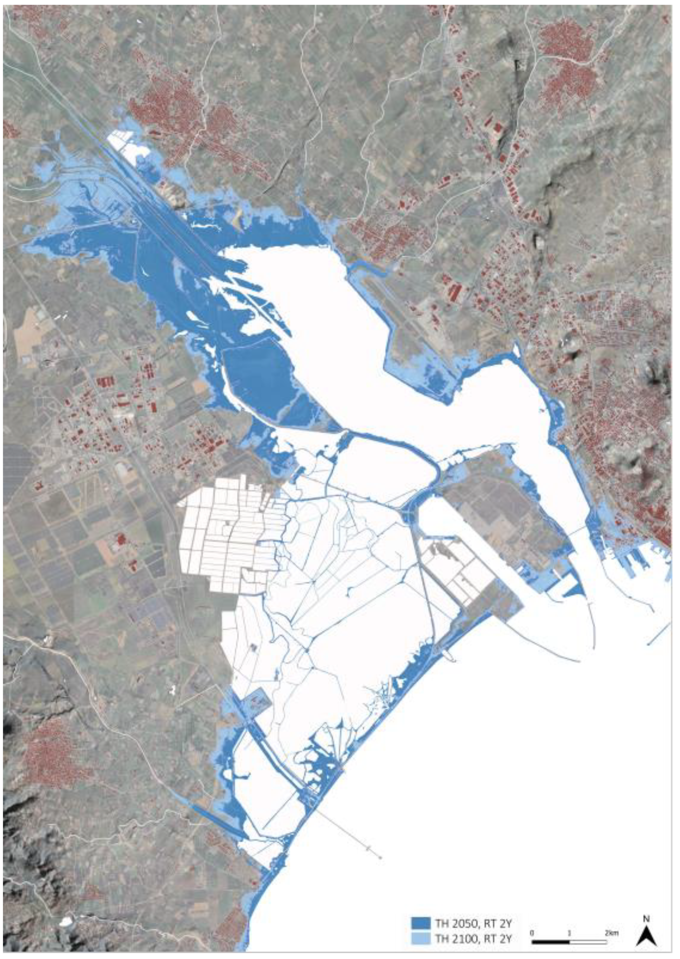
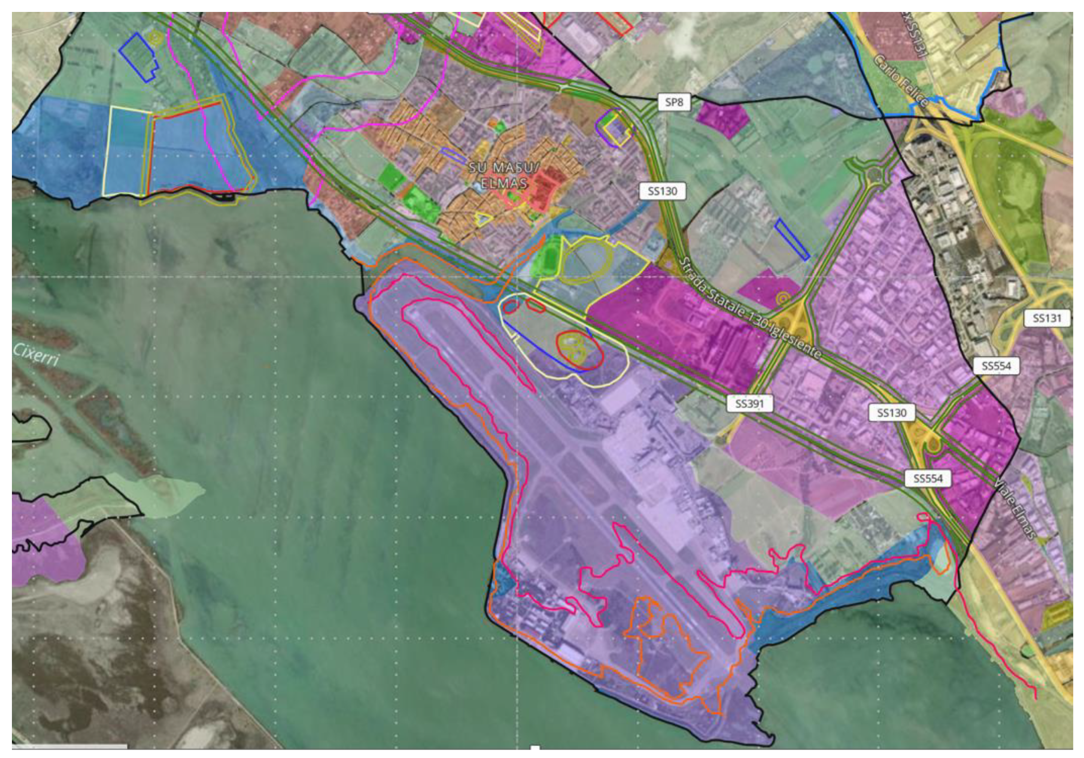
Figure 11.
Flooded area at 2050 and 2100. Local scale on the La Playa barrier beach.
Disclaimer/Publisher’s Note: The statements, opinions and data contained in all publications are solely those of the individual author(s) and contributor(s) and not of MDPI and/or the editor(s). MDPI and/or the editor(s) disclaim responsibility for any injury to people or property resulting from any ideas, methods, instructions or products referred to in the content. |
© 2024 by the authors. Licensee MDPI, Basel, Switzerland. This article is an open access article distributed under the terms and conditions of the Creative Commons Attribution (CC BY) license (http://creativecommons.org/licenses/by/4.0/).
Copyright: This open access article is published under a Creative Commons CC BY 4.0 license, which permit the free download, distribution, and reuse, provided that the author and preprint are cited in any reuse.


