Submitted:
24 October 2024
Posted:
24 October 2024
You are already at the latest version
Abstract
Contemporary urban areas are often characterized by various forms of enclaves, isolated from their surrounding geographical context. Urban Green Infrastructures provide an opportunity to open these enclaves, establishing physical and functional connections with the broader city, while also contributing to climate change mitigation and adaptation. This study examines the district of San Bartolomeo in the Italian city of Cagliari as an example of urban enclave and employs a participatory planning process to design a project that transforms it into a hub open to the wider city community. The result is a neighborhood shaped by its community, where social, economic, and environmental needs are balanced, fostering constant interaction between residents and the city as a whole.
Keywords:
urban enclave
; smart city
; urban green infrastructure
; climate change
; citizen science
; urban planning
1. Introduction
Since the second half of the twentieth century, the world has seen a remarkable transformation of urban structure resulting in urban fragmentation characterized by the proliferation of various forms of urban enclaves. Even though enclaves have been present in the cities and in the urban settlements since ages, in the last few decades a new pattern, called by scholars [1,2,3] “enclave urbanism”, emerged. The proliferation of fortified enclaves has created a new model of spatial segregation and transformed the quality of public life in many cities around the world. Fortified enclaves are privatized, enclosed, and monitored spaces for residence, consumption, leisure, and work. The fear of violence is one of their main justifications. They appeal to those who are abandoning the traditional public sphere of the streets to the poor, the "marginal," and the homeless. In cities fragmented by fortified enclaves, it is difficult to maintain the principles of openness and free circulation that have been among the most significant organizing values of modern cities. Consequently, the character of public space and of citizens' participation in public life changes [4]. The condition of contemporary urban areas is often characterized by the presence of entire parts of the city developed without establishing any connection with the relative geographical context. The phenomenon affects both public real estates, for civil and military use, and private properties, which establish different relationships, material and immaterial, direct, or indirect, with the urban context and with local communities. For example, large public complexes such as barracks and military sites or prisons, were conceived as spaces of exclusion rather than inclusion due to the nature of their original function. Similarly, the health centers, schools, old factories converted into places of culture or other compendia for civil use (sports centers, cultural and recreational centers) sometimes generate an obstacle to urban permeability due to their fences. Moreover, the logic of the shopping centers which centralize urban functions creates specialized areas isolated from the inhabited areas [5]. This trend, coupled with the climate change our planet is facing, is highlighting how adopting urban green solutions is the response most capable of connecting (opening) enclaves to the city while managing to act in a logic of mitigation and adaptation to climate change. Indeed, in the face of accelerating these pressures scientists and policymakers are calling for integrated solutions that operate “at the intersection of social, cultural, digital and nature-based innovation” [6]. The effective provision and management of urban green infrastructure (UGI), including urban trees, parks, blue and green open spaces, green walls, and green roofs, have the potential to provide both direct benefits (e.g., ecological connectivity and habitat conservation) and a range of co-benefits to urban societies, thereby realizing the goals of the United Nations 2030 Agenda for Sustainable Development and the new Habitat III urban agenda [7]. Co-benefits include increasing air and water quality, improving technological solutions for stormwater management, social cohesion, and increasing human health and well-being [8,9].
Due to their multifunctionality and the possibility of being implemented at various scales (building, neighborhood, city, territory), the realization of green areas is a win-win, economically beneficial and socially desirable solution, thanks to the numerous ecosystemic services they produce over their lifetime. These ecosystem services are nothing more than the benefits that human society derives from the nature, functions, and life processes of natural systems, even in the increasingly anthropized contexts of our territory.
For example, environmental services such as thermo-regulation and mitigation of the heat island phenomenon of urban centers, or the reduction of surface water runoff in the case of the increasingly frequent “water bombs” are important benefits that contribute to the perceived quality of life, people's health, and adaptation to the impacts of climate change. What's more, the possibility of moving and exercising outdoors and regenerating from city stress are other valuable benefits offered by the presence and enjoyment of green areas in the city, which provide an essential - but still too little studied - contribution to people's mental and physical health and well-being. This is confirmed by the fact that the presence of greenery is considered a determinant of health by the World Health Organization [10]. A recent international study involving 6 European countries showed how the period of isolation during the COVID-19 pandemic changed the value assigned by the people surveyed to green spaces, which became essential and of fundamental importance as places of mental regeneration [11].
Other important ecosystem services provided by urban and peri-urban green systems include biodiversity protection, capture of atmospheric pollutants, carbon storage, noise mitigation, aesthetic upgrading of urban landscapes and their property values, creation of environments conducive to healthy lifestyles and bicycle and pedestrian mobility, connection with rural areas, and social integration. All benefits that contribute to making cities and communities more sustainable (Goal 11 of the UN 2030 Agenda for Sustainable Development).
In parallel, the existing literature emphasizes digital infrastructure and the concept of the ‘smart citizen’ [12,13,14,15,16,17] and operators are progressively using digital solutions for urban greening in an effort to optimize, and in some cases democratize, the provision and implementation of UGI [18,19]. For example, automation is supporting UGI management in lawn care through autonomous lawn mowers [20], urban forest inventories feature digitally tagged trees that transmit information to smartphone platforms [21], biodiversity assessments are undertaken through gaming [22], citizen nature preferences are monitored through Instagram images and hashtags [23], and urban foraging is undertaken with community-developed semi-autonomous drones [19]. These technologies are driven by government and corporate goals of productivity (and profitability), but also by creativity and innovation, with the promise of “smart” and “real-time” solutions to environmental and social demands and challenges [18,24,25]. Taken together, these examples represent the kind of rapid technological development that suggests a potential upheaval in the field of UGI planning and management.
Looking at the policy level, in many international and European forum (G20 in Rome, COP 26 in Glasgow, Green deal, Strategy Fit for 55, European Biodiversity Strategy to 2030, and new Forestry Strategy to 2030), the issue of afforestation and reforestation is rightly seen as crucial to the restoration of all the planet's ecosystems and to achieving carbon neutrality in Europe by 2050. The European Biodiversity Strategy 2030 [26], for example, sets an ambitious goal of “planting at least 3 billion additional trees by 2030” (p. 10). The same document, along with the new European Forestry Strategy, also places great emphasis on green infrastructures in urban and peri-urban areas because they “reduce atmospheric, water and noise pollution, protect against floods, droughts and heat waves, and preserve the link between humans and nature” (p.13). Also, in the Strategy for Biodiversity to 2030, “the Commission calls on European cities of at least 20. 000 inhabitants to develop ambitious urban greening plans by the end of 2021, including measures in- tended to create biodiversity-rich, accessible woodlands, parks and gardens, vegetable gardens, green roofs and walls, tree-lined streets, meadows and hedges in cities, and also contribute to improving connections between green spaces, eliminating the use of pesticides, limiting excessive mowing of urban green spaces and other practices harmful to biodiversity” (p. 14).
2. The Italian regulatory and policy framework
In accordance with the new environmental and sustainable development policies promoted at the international and European levels, Italy has given itself Law No. 10/2013 “Norms for the development of urban green spaces” which represents a starting point for revitalizing the fundamental role played by urban green spaces, not only from an environmental point of view, but also from a social and cultural one.
Law No. 10/2013, the first and only nationwide law on urban greenery, has certainly contributed over the years to a greater awareness in the country and among local governments of green issues and their benefits for urban communities.
In implementation of Article 3(2)(c) of Law No. 10 of 2013, the “National Urban Green Strategy. Resilient and heterogeneous urban forests for the health and well-being of citizens” was drafted in 2018 by the National Committee for the Development of Public Green. It brings together a series of technical contributions and defines basic criteria to guide urban and peri-urban forestry policies in the country, in a new vision of urban green that places the following strategic objectives at the center of actions: 1) the protection of biodiversity and ecosystem services; 2) resilience to climate change; and 3) improvement of citizens' well-being and quality of life. The Strategy is based on three key objectives: to move from square meters to hectares, to reduce asphalt surfaces, and to adopt urban forests as a structural and functional urban green reference. The Strategy also calls for the involvement of stakeholders and necessarily multidisciplinary expertise to develop suitable public policies and direct municipal governments to implement plans and projects based on ecosystem services and the Green Infrastructure network (green infrastructures, nature-based-solutions), defined to achieve precise social, environmental, financial and employment objectives.
More recently, The National Recovery and Resilience Plan (Piano Nazionale di Ripresa e Resilienza - PNRR) [27] has dedicated a line of intervention (Mission 2, Component 4, Line of Intervention 3) to interventions dedicated to green areas: “Safeguarding air quality and land biodiversity through the protection of green areas, soil and marine areas.” This includes Investment 3.1 “Protection and valorization of urban and suburban green areas”, which provides for large-scale actions aimed at the 14 Metropolitan Cities, which are increasingly exposed to problems related to air pollution, the impact of climate change, and the loss of biodiversity, to improve the quality of life and well-being of citizens through the creation of urban and peri-urban forests.
Finally, Decree Dec. 23, 2021 approved the 20-year national forestry strategy, which included among its specific actions one related to “Trees and urban and peri-urban forests”.
Among the nationwide projects is the “Urban Green Challenge” project as it is the first collaborative and digital mapping of urban green. In its first trial, it involved 6 schools in 5 different regions. The project comes in two formats: the school trail, aimed at understanding environmental dynamics under the interpretive key of complexity, and the participatory civic crowdsourcing campaign. The goal of the project is to understand the importance of greenery within urban spaces: trees and shrubs are measured by participants using smart device apps in order to assess the benefits that vegetation provides to the ecosystem and all living things, including humans. Measuring these effects allows us to give an economic value, and not only landscape-cultural value, to the greenery present in our cities: this is a crucial lever to promote policies for the care and enhancement of green areas, including through the direct participation of citizens.
Within this framework, some municipalities (see Boxes in appendix about Modena, Florence, Bolzano, Mantua, Prato, Messina, Milan cases) have activated specific projects linking digital transformation, enclaves overcoming, and implementing green infrastructures highlighting the importance of the urban green infrastructures to mitigate the effects of climate change, and provide a wide variety of environmental, socio-cultural, economic and clinical-health benefits to cities. These cases, however, highlight two fundamental approaches. The first is a technological approach, based on the implementation of hardware and software, where technology represents the “smart” key, needed to be more efficient and competitive and based on the neoclassical paradigm of economic growth. The second is a substantially analogical approach, where the forestation action is almost completely disconnected from digital transformation actions. In both cases the logic is substantially top-down, and citizen participation is limited to the phase following the implementation of green solutions.
On the contrary, this research grounds its basis in the circular economy approach and considers technology as a tool to achieve broader goals, rather than as a goal in itself. Adopting a sustainable development perspective, the main targets are to protect biodiversity, to rethink urban development in terms of smart growth (i.e. to abandon urban sprawl and zoning, to adopt solutions that provide for a functional and social mix, to open the urban enclaves), to systematize skills to achieve common goals.
Within this framework, the paper aims to integrate the smart city paradigm with green infrastructure initiatives, emphasizing the essential role of citizen participation. To develop a comprehensive understanding of the smart city framework that goes beyond more technological implementations, a broader definition of “urban green space” is proposed that incorporates citizen science methodologies into urban planning, emphasizing the significant positive impact of citizen engagement as a critical factor for effective planning outcomes.
In other words, we intend to move from an approach focused on the vision of growth dominated by quantitative indicators, from the idea that the increase in productivity is infinite (infinite resources and consumerism), from the necessary competition (between peoples and between places), to development focused on qualitative indicators (performance), to the idea that resources are limited and must therefore be managed to ensure that new generations can benefit from them, to cooperation (between different actors and different disciplines).
True innovation (which is not only technological, but also social) can only be achieved through interdisciplinary approaches and break away from self-referential localisms. The idea that the urban district can be the “key” for a rethinking of the urban structure cannot and should not be understood as a new enclave but as a relevant “element”. It allows the use of most services, recalling the concept of the 15-minutes city [28,29] within a pedestrian way, but at the same time is interconnected with the rest of the city through smart and sustainable mobility networks.
3. Materials and Methods
The methodology of this paper is based on the citizen science approach. A participatory planning approach is essential to assess how green spaces and urban green infrastructure are integrated into spatial planning for improved outcomes. Participatory planning empowers stakeholders and decision-makers by fostering a sense of ownership and enabling meaningful involvement in decision-making. It encourages innovative interventions that benefit all social groups, builds trust among participants, and provides access to diverse perspectives, helping address grassroots issues and make informed, locally adapted choices. Public participation plays a crucial role in promoting social and environmental equity by bridging the gap between the objectives of planning organizations and the values of local communities and other stakeholders [30]. Actively involving the public has been instrumental in the success of green infrastructure projects in urban areas, fostering more inclusive and sustainable outcomes. By involving diverse stakeholders and citizens, green infrastructure can be more effectively leveraged to address urban challenges and promote sustainable development. In particular, the method is implemented through four succeeding steps:
- Analysis of the territorial context: This stage aims to reveal the spatial processes to identify and define the potential, aspirations and needs for a definite territory, from a social, economic, and environmental perspective to give value to natural and cultural landscape elements in urban scale. Data collection is performed through an objective (statistics, plans and programs) and subjective (citizen’s opinions and perceptions) approach. We employ a combined approach of in-depth interviews and content analysis of key policy plans and documentation related to greenspace planning and/or climate change adaptation to evaluate competence areas in our case study city.
- Identification of main issues: A SWOT analysis is carried out as a strategic planning tool to identify the strengths, weaknesses, opportunities, and threats of the context.
- Identification of project actions: To come from the questionnaires given to the citizens and from the analysis of the territorial context through a participatory process.
- Definition of the integrated scenario: Experts and citizens together develop a project proposal taking into the contextual constraints and the preferences expressed by the citizens.
More in detail, the participatory planning approach has been performed as the following: Analysis of the territorial context, identification of main issues, the analysis of the best practices, identification of alternative project actions, assessment of possible project actions, definition of the integrated scenario and the assessment of the integrated scenario.
A citizen science approach for adaptive urban greenspaces is suggested to integrate citizens’ needs and expertise. It includes adaptive strategies from climate change adaptation and ecological planning in a structured form to support the best practice to plan and improve greenspace in planning and practice. In the first phase, citizens were asked for their advice on the best planning for the S. Bartolomeo neighborhoods in Cagliari by means of a structured questionnaire. The questions in the questionnaire were formulated as follows. Citizens answered via a Qr code and link, as well as in person. In a second phase, the results were submitted to the citizens to verify the correct interpretation of the needs of the local population.
To evaluate the population’s needs for greenspace planning in the San Bartolomeo District, a qualitative research study was conducted. Between January and May 2023, an online questionnaire was distributed to the residents of the district. Data collection employed a non-probability snowball sampling method, where an initial group of participants was selected, and additional respondents were recruited in a second stage. The questionnaire was disseminated via email and through social media platforms and messaging apps, such as WhatsApp and local Facebook groups, using a QR code and a direct link.
This strategy was designed to reach a diverse audience, particularly in terms of age and socio-cultural background. Online surveys, following a citizen science approach, are increasingly recognized as an effective tool for reaching a broad participant base. They are gaining popularity in academic research, especially for exploring people-environment interactions and preferences [31,32,33,34]. The structured questionnaire consisted of 10 questions divided into several sections (see Table 1). The first section, with 3 questions, gathered demographic information to profile participants. The second section, comprising 5 questions, focused on perceptions of climate change, urban green spaces, and the district’s location, aimed at assessing participants' knowledge. Finally, the third section, with 2 questions, explored participants’ perceptions of their urban enclave and the role of green spaces in meeting community needs.
The questions were formulated using four different response types:
- single-choice questions, where respondents selected only one option;
- multiple-choice questions, allowing respondents to select more than one option;
- single-choice items presented on a psychometric Likert scale, requiring respondents to rate their agreement with specific statements (five-point scale: 1 - strongly disagree to 5 - strongly agree).
Responses were analyzed using the methodologies of descriptive statistics and results are reported in chapter 3.
3. Results
3.1. Analysis of the territorial context: The case of San Bartolomeo District
The San Bartolomeo district is located to the east of the historic city of Cagliari, in a marginal area. It is one of the 31 districts of the city of Cagliari. It is near the Sant’Elia Stadium (the Cagliari Calcio Stadium), and the homonymous social housing district (Sant’Elia District), which separate the neighborhood from the waterfront.
In the historical Guide of the City of Cagliari, written by Canon Giovanni Spano in 1861, it is documented that the area was already frequented in Roman times. However, the spatial configuration that we can still observe today can be traced back to the construction of the Bagni Penali in the first half of the nineteenth century. The prisoners were employed as a workforce in the activities of salt extraction. The new neighborhood of San Bartolomeo was built between the 80s and 90s approximately 500 meters apart from the remains of the old neighborhood. The symbols of the historic district are the square and the San Bartolomeo fountain which has recently been redeveloped. The new neighborhood is located further north, between the streets of Amerigo Vespucci, Raimondo Carta Raspi, Viale Salvatore Ferrara and the street of San Bartolomeo. The neighborhood is located south-west of the historic center of the city of Cagliari, it is close to numerous residential neighborhoods (Sant'Elia, Quartiere del Sole, etc.) and numerous territorial and social dominants such as the Cagliari Calcio stadium, the gulf of Calamosca, the Poetto coast, the Molentargius salt pans, etc. (Figure 1). The new district of San Bartolomeo is mainly used for residential use with sporadic exceptions of commercial services and with a large permeable green area (not equipped). It provides a series of neighborhood facilities, including squares, parking areas, dog areas, green areas, a local market, and a range of commercial activities, especially around the main square of the district (Piazza Francesco Antonio Boi). On the edge of the neighborhood are two areas that will be targeted in the near future by urban transformation projects. The building typology of the neighborhood is that of the residential building, organized in apartment blocks, with a different number of floors (from 3 to 8 floors), some of them with pitched roofs, others with flat roofs. The ground floors of the buildings surrounding the main square are intended for commercial activities. The analysis of the historical evolution of the urban settlement showed the development of the geographical context on which the San Bartolomeo district was built, in an area surrounded by a significant network of road infrastructures (Viale San Bartolomeo, Viale Salvatore Ferrara, Via R. Carta Raspi, Via Amerigo Vespucci). As a matter of fact, the district appears as an enclave within an urban context developed according to a functionalist approach: the urban space is organized by specialized functions of public interest and of different ranks (military, sports, university), each one surrounded by streets. Over time, the routes have been transformed from connecting elements with the city to urban limits for the neighborhood itself. These road routes have contributed to generating a cutting effect between the neighborhood and the remaining urban fabric. The same dynamic emerged relating to the system of military buildings, today totally incorporated into the urban fabric. This structure constitutes a caesura with respect to the surrounding space, a real enclave, because of the high fences equipped with barbed wire at the top that develop for some hundreds of meters. It’s to note that the military complex Attilio Mereu has been recognized of cultural interest in 2015 by the competent authorities, for the clear typological reference to the industrial architecture of the early twentieth century which still retains the original plant. The neighborhood is currently involved in urban regeneration initiatives, though these are still in the approval or planning stages by the Municipal Administration of Cagliari. One of the key projects includes the development of a sports complex in the northern part of the San Bartolomeo area, near Via A. Vespucci. To the west, as outlined in the guiding project submitted within the framework of the preliminary Municipal Urban Plan (Piano Urbanistico Comunale - PUC), the redevelopment of the Sant'Elia stadium area is also planned for implementation.
3.2. Residents' perceptions
The survey distributed to the residents of San Bartolomeo (Appendix 2) collected valuable insights into their perspectives on urban green spaces, climate change, and the local community. This information provides a clearer understanding of how greenspaces can be more effectively planned to address the specific needs of the community. The analysis of the questionnaire began by profiling respondents based on demographic data. The research findings were then examined along three key axes: (i) perceptions of climate change at the local level, (ii) governance tools implemented by public and private actors in the development of green spaces, and (iii) potential and targeted actions to mitigate the effects of climate change. A total of 60 online questionnaires were collected, as outlined in the methodological section. Questionnaire respondents were predominantly female (68%), with a majority aged 20-59 (86%). Education levels were varied, with 18% holding university degrees, 42% having completed high school, and 40% reporting other qualifications.
A significant majority of respondents (70%) expressed concern about the climate crisis and its potential impact on their lifestyle (65%). While 82% felt their district was not well-connected to the city, 70% perceived poor internal connectivity. When asked about desired changes, respondents overwhelmingly prioritized more green spaces (70%), followed by spaces for children (60%) and pets (30%). Other preferences included gym facilities (35%) and co-working areas (20%). Key negative aspects of the district included poor public transportation, lack of green spaces, and inadequate infrastructure, while positive aspects were proximity to natural areas and beaches, affordable living costs, and low traffic congestion.
3.3. Identification of critical issues
The SWOT analysis summarizes our previous research findings on the San Bartolomeo neighborhood and identifies the key strengths, weaknesses, opportunities, and threats that influence its development. The strengths and weaknesses concern internal aspects of the analyzed system, while the threats and opportunities are the result of external actions channeled respectively on the strengths and weaknesses.
Strenghts:
- located in a historically and environmentally significant area;
- availability of undeveloped land;
- sports facilities;
- adequate parking spaces to current needs;
- quiet residential environment;
- neighborhood-level facilities and proximity to local and regional services.
- served by local public transportation;
- WiFi hotspots
Weaknesses:
- not efficient road network and public transport;
- limited pedestrian connections and reliance on cars;
- lack of neighborhood-scale energy initiatives (photovoltaic systems or energy communities);
- lack of smart devices (devices for electric charging, lockers, neighborhood apps);
- absence of common spaces and concierge services;
- deterioration of the Municipal Market;
- isolation determined by the presence of elements of separation;
- fragmentation due to the presence of heavy mobility systems,
- safety concerns;
- insufficient and unevenly distributed green areas;
Opportunities:
- promoting activities related to nearby environmental and sports facilities..
- reconverting empty spaces into green areas for social purposes.;
- benefits from the new stadium of Cagliari calcio (urban park, promenade, and football school)
- realization of a light rail station near the Cagliari Calcio Stadium.
- Threats:
- potential for traffic congestion due to football matches and growing visitors;
- limited parking availability for the expected influx of visitors to the new Cagliari Calcio Stadium.;
- risk of neighborhood decline due to degradation;
- presence of unqualified residual spaces;
- disconnected green (via Tramontana near the Molentargius Park, Viale San Bartolomeo which extends to CalaMosca) and blue infrastructure routes (the Rio Palma navigable canal which radiates from Molentargius to intercept an important segment of the Cagliari waterfront).
3.4. Definition of project actions
According to a participatory planning approach, the district's residents have been involved in 3 meetings to define the possible project actions. These meetings have been organized following the “world cafè” methodology to create a safe, welcoming environment in which to intentionally connect multiple ideas and perspectives by engaging participants in several rounds of small-group conversation. At the start of the first World Cafè the results of the SWOT Analysis were shown and explained to give the participants the same knowledge base. In each World Café meeting, participants (60 people) were divided into 3 tables and had an hour and a half to discuss possible projects to implement in the area. In each meeting there were three rounds (i.e. three table’s changes for each participant). Each table had a “host” who remained at the table through the entire exercise. The host’s role was to welcome participants to the table, provide an overview of the discussion question, and summarize key ideas shared by previous guests at the table. At the end of the exercise, the host was responsible for sharing a summary of the discussion points from his or her table. The following projects emerged from the World Café meetings:
- Spirulina production plant
Spirulina seaweed is a blue-green microalga (it belongs to the blue seaweed group). It is a highly regarded superfood due to its status as a complete nutritional source. This type of algae thrives in freshwater environments such as lakes, rivers, and ponds. Spirulina is rich in various nutrients, including fat-soluble vitamins (A, E, and K), essential fatty acids (DHA and EPA), beta carotene, and an array of minerals. While it serves as a protein source, it does not contain sufficient levels of some essential amino acids required for optimal bodily function, unless one has a medical condition that necessitates avoiding specific amino acids. Additionally, since spirulina originates from bacteria, specifically “cyanobacteria,” it is considered a viable protein option for vegans. The production plant uses photo bioreactors, or plastic tubular solar collectors in which pure groundwater circulates and in which the seaweed grows. This particular plant allows the least contact of water with air, preventing contamination of the algae.
- 2.
- Hydroponics Systems
Hydroponics is a cultivation method where plants grow without soil. Nutrient-rich water, maintained at the ideal pH, supplies essential elements directly to the plant roots, ensuring efficient absorption. Unused water is recycled for reuse. Plants in hydroponic systems are supported by inert substrates like pumice or coconut fiber, or they are placed in tubular structures with flowing nutrient-rich water. Hydroponics bridges traditional agriculture and aquaculture. These systems feature water-filled basins housing fish. Plants, supported by slabs with holes, absorb nutrients directly from the water. Fish maintain water quality and provide nutrients for the plants. Hydroponic systems utilize inert substrates or tubular structures with flowing nutrient-rich water, eliminating the need for soil.
- 3.
- Eco-compactor
Eco-compactors are recycling stations strategically placed in public areas. These machines accept various plastic caps, including PET, PS, PE, and HDPE bottles, as well as aluminum cans and PP glasses. Users receive a small monetary reward in the form of discount coupons for their contributions.
Eco-compactors are automated machines that sort and compact waste. Each deposit earns a receipt with a contribution or discount voucher redeemable at participating businesses. This incentive recycling model promotes environmental education.
- 4.
- Little Composting System
Composting, also known as controlled decomposition, necessitates a careful balance between “green” organic materials and “brown” organic materials. “Green” materials, such as grass clippings, food scraps, and manure, are rich in nitrogen. In contrast, “brown” materials, including dry leaves, wood chips, and branches, are high in carbon but low in nitrogen. Achieving the ideal nutrient mix often requires experimentation and patience, which is an essential aspect of both the art and science of composting. The size of the particles used in composting plays a crucial role; grinding, chipping, and shredding materials increases the surface area available for microorganisms to feed on. Smaller particles not only create a more uniform compost mixture but also enhance pile insulation, helping to maintain optimal temperatures during the decomposition process.
- 5.
- Co-Working
Coworking has gained significant traction in the digital knowledge economy, driven by the growing number of independent professionals who often work from home and may lack the social connections needed for feedback, referrals, and support. Shared experiences of working remotely and a mutual understanding of the challenges associated with personalized professional endeavors foster cognitive proximity within home-based coworking environments. Coworkers actively contribute to a productive atmosphere, which is supported by digital platforms, host engagement, and home-based features.
- 6.
- Floor drainage
The impermeable surfaces of public parking lots generate a substantial amount of surface water runoff, necessitating effective channel drainage solutions. For larger commercial parking facilities, drainage systems are optimal for managing surface water, with larger designs offering additional capabilities. Multi-storey car parks and parking decks often face challenges related to limited installation space for drainage solutions. In St. Elia’s Masterplan, which includes numerous parking areas, has opted to prioritize sustainable environmental practices through the implementation of drainage systems.
- 7.
- Buffer strip
A buffer strip is a designated area of land that is permanently covered with vegetation, designed to improve air, soil, and water quality while addressing various environmental issues, particularly in agricultural settings. These buffer strips effectively trap sediment and enhance the filtration of nutrients and pesticides by slowing surface runoff before it reaches local water bodies. The root systems of the vegetation in these strips help bind soil particles, reducing wind erosion and stabilizing stream banks, thus offering protection against severe erosion and landslides. Farmers can also utilize buffer strips to better align existing crop fields, which not only enhances safety for equipment but also promotes more efficient farming practices. Buffer strips can feature a variety of vegetation configurations, ranging from simple grass to combinations of grass, trees, and shrubs. Areas with diverse vegetation provide improved protection against nutrient and pesticide runoff while simultaneously fostering greater biodiversity among plants and animals.
- 8.
- Urban Agriculture
Urban agriculture is transforming city landscapes, with a surge of small-scale operations dedicated to cultivating plants and raising animals at ground level or on rooftops and terraces. Urban horticulture encompasses the cultivation of vegetables, fruits, aromatic plants, and medicinal herbs, conducted either outdoors or in enclosed spaces on a domestic scale. Urban vegetable gardens minimize the number of intermediaries involved in the food supply chain, leading to reduced transportation, packaging, and storage costs. This not only increases the earnings of horticulturists but also decreases environmental pollution. Additionally, these initiatives create job opportunities for disadvantaged groups and individuals at risk of exclusion. Urban agriculture plays a vital role in providing fresh food to the population, creating green spaces, recycling municipal waste, and enhancing urban resilience against climate change. Urban vegetable gardens exemplify the principles of a sustainable city. Community gardens have evolved beyond mere vegetable plots to become spaces for leisure, relaxation, environmental education, and therapeutic experiences in natural settings. Many citizens now actively engage in private or community urban vegetable gardens, and municipal authorities increasingly incorporate these initiatives into their sustainable urban planning efforts.
- 9.
- Kayak anchoring
A kayak anchoring action plan in the city focuses on creating accessible, sustainable, and eco-friendly facilities that integrate with urban spaces. Strategic locations near parks and public transport hubs encourage easy access, while sustainable materials and designs protect local ecosystems. These facilities link to green spaces, promoting outdoor recreation and healthy lifestyles. Community involvement is encouraged through educational programs on kayaking and water safety, and citizens can participate in environmental monitoring. The plan also supports local businesses by attracting visitors through rentals and tours, boosting the local economy. Additionally, cultural and historical connections can be highlighted along kayaking routes, enhancing the city's appeal. Smart technology and water management systems ensure the facilities are efficient, sustainable, and safe, turning kayak anchoring into a valuable urban asset.
- 10.
- Cardio outdoor gym that generates electricity
The outdoor cardio equipment that generates electricity promotes not only physical health and mental well-being but also community spirit and environmental sustainability. This innovative equipment harnesses human energy and converts it into usable electricity, which can be utilized to charge mobile phones and tablets via a USB port and to illuminate on-site interactive lighting. While it is well established that physical activity enhances both physiological and psychological well-being, more evidence is needed to determine how various environments influence health outcomes. Additionally, exercising in outdoor settings appears to provide unique physiological and mental health benefits. However, people’s connection to nature seems to be evolving, which has significant implications for how humans engage with the natural world.
- 11.
- District’s open-air market
The development of an open-air market within a district plays a crucial role in promoting local commerce, community engagement, and sustainability. It serves as a vibrant hub where local vendors sell fresh produce and handmade goods, fostering economic activity and cultural exchange. By supporting short food supply chains, the market reduces transportation and packaging, making it eco-friendly. It connects local farmers with residents, promoting trust in food quality and preserving local traditions, while also attracting tourists. Flexible in design, the market can host community events, creating a sense of unity and serving as a social and cultural focal point, aligned with the city’s environmental goals. The market would provide a platform for local farmers and producers to directly connect with residents, enhancing trust in the quality and origin of food. This setup would also help preserve and promote local food traditions, making it a point of interest for tourists seeking authentic experiences. The market could include designated areas for food vendors, craft stalls, and seasonal pop-up spaces for special events, contributing to the district’s identity as a center of sustainable, local living. Finally, the open-air market would integrate commerce, culture, and sustainability, enriching both the community and the city’s economic vitality.
- 12.
- Solar panels
The stadium will feature solar panels installed on the root and most of its external vertical surfaces to harness solar energy during the day. A battery storage system will facilitate the accumulation of this collected energy, transforming the stadium into an “energy supply hub.” This setup will also help mitigate the grid impact of numerous electric vehicles charging simultaneously from various locations. As a key outcome, the stadium will achieve 100% energy self-sufficiency, with any surplus energy allocated for several purposes:
- Illuminating poorly lit areas of the St. Bartolomeo district at night, thereby enhancing the livability of public spaces and promoting social activities;
- Charging e-bikes and scooters for residents and visitors to Cagliari who are drawn to the stadium and the surrounding sports facilities.
- 13.
- Energy-generating floor
The project foresees an energy-generating floor around the football pitch to harness energy from citizens walking in the area. These floors convert the kinetic energy generated by pedestrians into usable electricity, which can then be redirected to power nearby facilities, such as lighting for the pitch, surrounding pathways, or public amenities. The system promotes sustainability by encouraging green energy practices within the community while simultaneously enhancing the functionality of the space. By incorporating these energy-harvesting technologies, the city encourages active participation from its residents, linking physical activity to environmental benefits. The initiative also aligns with broader goals of smart city development, where technology and infrastructure work together to create more sustainable, energy-efficient urban environments.
- 14.
- Cycling and walking paths
Enhance the availability of cycling and walking paths surrounding the Sant’Elia football stadium, which will have direct positive effects on:
- Citizens’ health by promoting increased engagement in sports activities
- Reducing air pollution
- Fostering environmentally sustainable mobility within the district and its neighboring areas
- 15.
- Tactical urban planning solutions for road intersections
In district mobilities, project strategies are aimed at the identification of strategic crossing and connection areas according to the main axes of connection identified. Tactical urban planning uses low-cost, temporary solutions to improve road intersections while working toward permanent changes. Common interventions include painted curb extensions to slow traffic and shorten pedestrian crossings, temporary bike lanes for safer cyclist positioning, and pedestrian plazas that reclaim excess road space. Creative crosswalks and pop-up markings increase pedestrian visibility, while enhanced lighting improves safety. This approach allows for real-time experimentation and community feedback, making it easier to identify what works best in specific contexts. These flexible, quick fixes allow cities to test ideas, prioritize safety, and encourage more sustainable, pedestrian-friendly environments.
- 16.
- Smart Totems
The deployment of multifunctional smart totems along the cycling and walking paths in order to:
- measuring and monitoring air quality in the district by increasing the number of monitoring points across the City of Cagliari and expanding the range of detectable pollutants to include not only PM2.5 but also PM10, O3, NO2, and SO2;
- collecting solar energy through vertically integrated solar cells, thereby reducing CO2 emissions by approximately 300 kg per year for each totem, based on Italy's energy production mix;
- providing illumination during nighttime;
- supplying power for e-bikes and electric kick-scooters;
- offering free Wi-Fi connectivity;
- serving as an information point for mobility issues and daily events in the city and district.
- 17.
- Improvement of the St. Elia local market
The plan involves establishing public urban gardens near the local market where operators, who also sell in the market, will cultivate local fruits and vegetables. This initiative supports a short food supply chain, strengthens the local food system, and builds trust in food quality among residents. It also aims to raise awareness of local traditions among younger generations and offer tourists an authentic taste of local cuisine. Access to the gardens will be free, governed by a service agreement between the City of Cagliari and local market operators or private citizens. Agreements will also allow residents from diverse cultural backgrounds to grow products not available in the Sant’Elia market, promoting a cultural exchange through food. Additionally, the project proposes the creation of a community kitchen and food hub, “Assaggia San Bartolomeo”, transforming the market into a space for cooking, dining, and tasting. Operating daily, the hub will enhance social ties and community collaboration. The hub and gardens will foster a sense of belonging and integration, supported by social activities that encourage community cohesion. Events at the hub will address community issues, celebrate food cultures, and combat food waste. The hub’s role will be further reinforced through partnerships with local schools and universities, offering activities that promote cultural appreciation and social engagement. Finally, the hub will serve as a social and culinary point of connection for residents using nearby sports facilities or passing through on bikes and scooters.
- 18.
- Linear green
The proposed solution aims to enhance connectivity and integration with the surrounding areas. The linear green spaces have several important objectives aligned with the ecosystem services they provide, including:
- Enhancing the visual experience of the area, ensuring a level of visual complexity that increases the enjoyment of green spaces;
- Strengthening ecological corridors to promote territorial and ecosystem continuity;
- Reducing fine dust and pollutants in the atmosphere, as these green surfaces serve as effective physical, chemical, and physiological filters against harmful airborne particulates;
- Establishing a barrier to mitigate noise pollution generated by vehicular traffic.
- 19.
- Green Areas
We have previously addressed the presence of uncultivated and vacant spaces surrounding the neighborhood, highlighting the necessity to transform these areas into functional spaces through urban forestry initiatives. These green spaces can serve as multifunctional mediation areas, both urban-territorial and social, fostering community engagement among residents and beyond. Opportunities presented by the development of sports facilities to the north of the neighborhood is the implementation of green roofs on the four football fields, featuring drought- and salinity-resistant macrothermal species. It is noteworthy that this area once hosted salt marshes, making such vegetation particularly suitable. Incorporating microthermal species, known for their resilience against pathogens and foot traffic, would enhance eco-compatibility and cost-effectiveness in maintenance. This type of vegetation cover offers several advantages, including the ability to irrigate with treated wastewater, given its high salinity resistance. A collaborative relationship could be established with nearby residential buildings, where the green spaces would provide various ecosystem services, while the residential community could supply adequately purified water for irrigation.
- 20.
- Green roof and green wall
The redevelopment of the St. Bartolomeo district aims to provide various ecosystem services. To align with the environmental needs of the community (comprising residents, commuters, and workers) the study is approached at multiple scales, including territorial, neighborhood, and microscale levels. Green roofs and facades are particularly relevant at the microscale. In this context, flat roofs will be transformed into green roofs to enhance building insulation and facilitate outdoor activities related to horticulture, gardening, and the cultivation of pollinator species, such as beekeeping. This approach embodies a perspective that transcends anthropocentrism and promotes the establishment of ecological networks. Green walls will serve dual purposes:
- Providing insulation for living spaces and contributing to energy savings, while also mitigating the landscape discontinuities created by the new neighborhood's construction;
- These walls will effectively address the interruption of the skyline formed by the heights of the new buildings, harmonizing the view with the backdrop of St. Elia’s hill.
- 21.
- Rain garden
Another key design feature involves the implementation of rain gardens. These gardens, integrated along the main “slow” road infrastructures such as cycling and pedestrian paths, contribute significantly to achieving essential ecosystem objectives. Rain gardens consist of sunken, draining areas populated by plant species that can withstand both drought and temporary root asphyxiation caused by water stagnation during heavy rainfall. These depressions effectively collect and manage water runoff from adjacent impervious surfaces, thereby minimizing disruption to vehicular traffic.
The functions of the rain gardens can be summarized, though not exhaustively, as follows:
- green Barrier: they serve as a green buffer surrounding the cycling and pedestrian paths, providing a clear separation from other road infrastructures. This green component not only delineates the pathway but also ensures adequate visibility for both pedestrians and cyclists, enhancing safety;
- phytoremediation: the water collected from impervious surfaces often contains significant pollutants. Therefore, the selected plant species for the rain gardens will also play a crucial role in phytoremediation—either inactivating or retaining these harmful substances within their tissues.
- 22.
- Mini static bio stabilization plant
Plant for the production of soil conditioner/fertilization obtained through Static Bio stabilization of agricultural residues/by-products and animal manure. The heap does not need to be turned over and a special enzyme (patented) to which earthworms are added. This enzyme has the ability to prevent the proliferation of bad odors. In the heap just described, residues from “agriculture” can be used, but not fish stew: with the heap of fish stew, a special film for domestic use can be obtained.
- 23.
- Water houses
These are Pay-as-you-go water dispensers consisting of a prefabricated structure housing activated carbon filters, cooler/gas bank, CO2 cylinder exchange system, CO2 cylinders, electronic display, coin box, pump to regulate water pressure.
- 24.
- Aquaponic plants.
These are a middle ground between hydroponic plants (for vegetable and vegetable production) and aquaculture plants (fish production). They usually consist of tanks of water filled with fish in which polystyrene/plastic plates are placed with holes in them for the roots to draw nutrients directly from the water. The presence of fish serves to purify the water and their feces constitute nourishment for the plants.
Three additional non-tangible actions were identified during the process in order to encourage citizen engagement and foster greater citizen participation.
- 25.
- Grow it yourself
Grow It Yourself is an initiative aimed at encouraging the cultivation of products for the table in residents’ balconies, terraces, gardens, and urban gardens. A series of digital workshops and monthly "ask the expert" sessions are planned to provide new farmers with the tools and knowledge necessary to succeed in the new activity. In addition, social eating events will be organized once a month, during which it will be possible to share the products of your own work.
- 26.
- Business Mentoring
Business mentoring is a program aimed at supporting local entrepreneurs, promoting sustainable economic development, and creating new job opportunities. It offers a support program for both new and experienced entrepreneurs to start, grow, and renew innovative and environmentally friendly businesses. It provides personalized consulting services to help entrepreneurs achieve their growth objectives.
- 27.
- Eco-friendly Citizens
Eco-friendly Citizens is a program designed to support local communities in becoming more sustainable by providing them with tips to reduce waste and consumption of energy and water. Additionally, they will be guided in choosing products that are as environmentally and socially sustainable as possible.
3.5. Definition of the integrated scenario
To define the integrated scenario, a further, and final, meeting was organized, in order to choose the localization of the different projects and to design the new district landscape. This phase was critical to ensure that planning solutions were effectively integrated, otherwise they risked exacerbating the neighborhood’s isolation rather than promoting connectivity.
More specifically, the neighborhood was envisioned as a hub, serving as a “trait d'union” that connects the entire residential area to key territorial infrastructures - currently the very elements that delineate and segregate the neighborhood.
With this vision in mind, the linear green has been concretized in a new tree-lined corridor traversing Via F. Alziator, the neighborhood’s main street, transforming it into a vibrant green promenade that connects to services associated with the St. Elia’s guide project and the Cagliari waterfront (Figure point 1). This diagonal corridor will intersect with access routes leading to the St. Elia promontory and Cala Mosca. To the north of the small neighborhood park, named after the esteemed historian F. Alziator, pathways will branch out towards sports facilities and a designated canoe launch and anchorage. This launch, planned at the entrance of the ancient canal that once fed the salt pans at the base of the Lazzaretto, is situated near the university’s biology faculty, which has become somewhat isolated but was historically an integral part of the San Bartolomeo neighborhood.
The area between St. Elias Market and where the temporary stadium currently stands (Figure point 2) will be the hub of the neighborhood after the new stadium is built. There will be a significant influx of people attracted by sports, recreation, commerce and leisure activities. A Co-working facility will be built here within a multifunctional structure comprising:
- Co-working/hub for digital start-up with spaces and workstations with ample light sources and common areas (to encourage contamination between people with different experiences), these environments will be partially separated by hydroponic/aquaponics systems. There will also be areas for relaxation and physical activity with sports equipment from which energy can be produced.
- Laboratory for smart cities, urban agriculture - a sort of “Think-Thank” formed by agronomists, engineers, architects, planners, experts in public procurement/partnerships/concessions, researchers, representatives of the productive world and administrators to redefine new parameters and solutions for the arrangement of cities and its relationship with the territory.
For the spirulina production plant have been identified two suitable sites: an unused area between Borgata S.Elia Street and Ferrara Street (Figure 2 point 3), where there will be other initiatives, where horizontal photo blasters will be placed and the production can be sold on site in the producers' market; the Nervi Pavilion (Figure. 2 point 4), a former salt warehouse from the 1950s, newly restored and set in a park of about 2 hectares between the St. Bartolomeo canal and Su Siccu. There will be areas for refreshments and physical activity. This intervention is part of a larger recovery project that includes the Bonaria shoreline, Su Siccu harbor, St. Elia waterfront, Parco degli Anelli and the Lazzaretto. Being located on a quay, the pavilion represents the most suitable location for algae plants because they have in common the element of water (particularly seawater), the presence of the sun, and in addition there is the advantage of the large influx of tourists and citizens. Vertical and horizontal photo bioreactors can be placed inside the Pavilion, while horizontal ones can be placed in the park.
The area between Salvatore Ferrara street and Borgo St. Elia street (Figure 2 point 5) will be an extension of the physical market of St. Elia, where it will be possible to have moments of meeting and social interaction, taste 0 km products, urban agriculture and the adjacent garden, enjoy local and seafood dishes. Given the lack of space in the St. Elia market location, in this area will be located food service of the products of the urban garden, fish farms from aquaculture/aquaponics and superfood from the seaweed plants. It can also be set up as a delivery for the sale of food and a take-away for the dishes prepared with resources from the urban area of the individual protections. Waste produced in the restaurant/take-away and food box activities can be conveyed to a designated space in the chosen area or directly to the wet waste platform in the ecocentre.
In the area between Vespucci Street and Fiorelli street (Figure 2 point 6), currently unused, will be implemented:
- eco-sustainable gymnasium, the equipment will be placed outdoors and will allow energy to be produced through use by the athletes;
- canoe anchorage, for those who wish, it will be possible to use this type of boat to do sports activities in the St. Bartholomew Canal. Buffer strips may also be built here (Fig. 2 point 7);
The inclusion of buffer strips along major road axes would allow a decrease in noise pollution and CO2 storage, as well as make adjacent public spaces safer.
Finally, several services will be distributed in the neighborhood as shown in Figure 2: draining pavements, to avoid soil sealing (point 8), mini static biostabilization plant heap of plant by-products (point 9), water houses (point 10), hydroponic systems (points 11), aquaponic plants (points 12), eco compactors (points 13).
The final result of the participatory planning project was elaborated in a 3D view, as shown in Figure 3, where today's situation of Figure 1 could be compared with the planned one.
The participatory planning approach described doesn't face the operative phase, that is the decision of the priorities according to financial, bureaucratic and social preference boundaries. The authors intend to explore these aspects further in a subsequent work aimed to define a multicriteria analysis as decision support tools for the administrations.
4. Conclusions
Considering that previous studies in the literature focused on some variables as quality, quantity, access, systemic contribution, interconnectivity of open green spaces [35,36,37,38,39,40], it is necessary to increase this holistic framework highlighting the relationships between landscape, open green spaces, and city. The collected publications are being used for our exploration in defining the Urban Greenspace System, nature-based urban climate change adaptation and how they interrelate in urban planning and urban enclaves as urban green infrastructure to interconnect urban spaces. We reviewed the literature to identify potential new concepts, principles and goals in urban greenspace planning and urban enclaves’ features.
The project concepts, as we discussed, draw inspiration from Nature-Based Solutions (NBS), emphasizing the significance of the natural world and the ecosystem services it provides. These solutions aim to enhance the sustainability of urban systems, restore degraded ecosystems, implement adaptive and mitigation strategies in response to climate change, and improve risk management and resilience.
A participatory planning approach was adopted to analyze the territorial context, identify key issues, explore best practices, and develop alternative project actions. A citizen science approach for adaptive urban greenspaces integrated citizens' needs and expertise. It incorporated adaptive strategies from climate change adaptation and ecological planning to inform best practices for greenspace planning and implementation.
The project themes illustrated can be valid elements to focus on in a perspective of a smart approach for the redevelopment of urban neighborhoods.
It is believed that the set of topics covered includes the strategic objectives that must be considered for greater environmental, social and economic sustainability. The objective is to guarantee all citizens access to green areas and safe and inclusive public spaces, as well as access to basic services through the redevelopment of urban neighborhoods with actions able to support and promote economic, social and environmental growth among communities. Through appropriate empowerment actions, we want to accompany the cultural development of residents in an interface between place and community, between anthropic space and nature capable of nurturing the creativity and participation of residents in a perspective of well-being and harmony with the environment.
Author Contributions
Conceptualization, C. Di Fazio and L. Mundula; Methodology, C. Di Fazio and L. Mundula; Software, C. Di Fazio and F. Leccis; Validation, L. Mundula and M. Paradiso; Investigation, C. Di Fazio, F. Leccis, and L. Mundula; Data Curation, C. Di Fazio and F. Leccis; Writing – Original Draft Preparation–, C. Di Fazio and L. Mundula; Writing – Review & Editing, C. Di Fazio and L. Mundula; Supervision, M. Paradiso.
Acknowledgments
Acknowledgments to the dr. Ferdinando Manconi, Agronomist and landscaper, for the making of the figure 3.
Conflicts of Interest
The authors declare no conflicts of interest.
Appendix A
Box 1 - Modena
A platform has been created in Modena to make the city's green areas 'smart' that can collect databases and information in real time and offer various features and predictive analysis and simulations, for example, on the variation of pollutants in the atmosphere based on the presence and consistency of green areas. The platform-which finds its regulatory framework in the Digital Plan 2020 of the City of Modena (approved last July by City Council Resolution 29/2020) and in the Three-Year Plan for Information Technology in PA 2020-2022 of the City of Modena (approved by City Council Resolution 803/2020) - will support the city's various spatial planning tools (in addition to the Green Plan, the General Urban Plan - PUG, the Sustainable Urban Mobility Plan - PUMS, the PAESC formerly PAES - Sustainable Energy Action Plan) and will be fed by data generated by the public green maintenance service, external maintainers, through field census, environmental sensor tools and city smart mobility tools (such as the one for monitoring traffic flows). Several functionalities converge in the platform: citizens can consult open data, map maps, and send reports; at the administrative level, an integrated system of spatial information data, budget data, deeds, contracts with suppliers, and maintenance certificates can be used; through the directional dashboard, decision makers can consult the tree budget and make forecast analyses. One can dialogue with the platform through different interfaces: from the municipal portal, through dedicated apps, and thanks to a blockchain from the digital signature of the maintainer, plant analysis can be certified. In addition, thanks to the collaboration with ARPAE and the faculty of environmental engineering of the University of Modena and Reggio Emilia, it is planned to implement the network of sensors, calibrating them for air quality monitoring in green areas.
Box 2 - Florence
“Florence Green smart city” is a package of initiatives to combine the smart city with the environment. A set of interventions implemented thanks to European funds, structural funds, internal human resources in the municipality, technologies for the Internet of Things, and citizen participation.
- The SIVEP - Public Green Information System, is a completely open source system that manages the entire process of Public Green maintenance, allowing to deal with trees, green areas and their classification, rows, games, the plants and hedges. In particular with regard to tree planting, starting from the management of Visual Tree Assessment - VTA in a georeferenced way, to the production of the computer document for the management of the planting process. The system manages trees, green areas, street furniture, rows, playgrounds, plants, and hedges. Green areas are managed functionally at the sub-area level (sports area, dog area, play area, etc.). For each managed object, it is possible to add data for web publication regarding the equipment present. This data can be updated automatically through the geographic reports, since they are themselves geographic archives. It is also possible to add images and movies, giving the citizen better and more up-to-date information.
- The “Donate a tree with dedication” project, included in the environment portal, allows people to donate and dedicate a tree to their loved one with a simple click. The web platform allows users to choose the type of plant to donate from 10 species considered compatible by the Environment Directorate for the chosen location. The plaque on the tree contains the name of the person to whom the plant is dedicated and a Qr Code that links to the dedication. The dedication can also be viewed online if the donor gives consent to view it. A heart appears on the web platform on each donated tree.
- The “A Tree for Every NewBorn” project aims to make it even clearer and more engaging for citizens to comply with the law requiring the planting of a new tree for every newborn. The system automatically and randomly links the new tree planted to the tax codes of newborns. It is therefore not possible to choose the tree to be associated with the newborn, but it is possible to view the location of the tree associated with your son or daughter on the online map.
- Two “smart irrigation” systems have been activated in the new gardens at the former Galileo Workshops and Porta Leopolda. Dozens of sensors measure temperature, soil moisture, wetting, and through the cloud connect to the internet to take in weather forecasts deciding how and when to irrigate. The data is also shared with citizens through information panels located in the two gardens that via QrCode will bring the information in realtime to the smartphone. This system saves 30 percent of the water used to water the city's public green spaces, optimizes environmental workers' inspections resulting in reduced travel thanks to automatic leak detection or sending alerts for faulty sensors and sprinklers.
- These data arrive in the “Smart control room,” where they are monitored not only by the city's technical directorates but also by the utility companies that are involved with their activities on the 'smart' gardens. Data on everything to do with city surveillance and management (traffic, garbage collection, street cleaning, public transportation) also converge in this hub, allowing better coordination between different departments and more effective actions and services.
Box 3 - Bolzano
The city of Bolzano, in partnership with the city of Lugano, has developed a portal for citizens to inform in real time about the status of greenery in the city. in order to highlight the value of public greenery and how it contributes to more resilient urban environments based on the belief that communicating with citizens about the environmental value of their city in a clear and immediate way is of particular importance especially now, at a time when strategies are needed to cope with increasingly frequent heat waves, droughts, and extreme weather events. To implement the new portal in the two partner cities, the project pursued four specific objectives. Initially, a methodology was identified for collecting and updating Urban Green data, through which a detailed census of the elements in green areas was conducted. Good management of urban green areas, in fact, cannot disregard a thorough knowledge of the elements found within it. The new census provided detailed information on the heritage, which allowed for a greater understanding of the true value of Urban Green: a snapshot of the heritage that has environmental, cultural, social and, last but not least, economic significance. From there, the GreenSpaces GIS information management platform was then updated to implement the new data model and develop the functionality needed to quantify the ecosystem services of trees and shrubs. This enabled the final goal of sharing the results obtained with citizens and giving them maximum visibility through the creation of the Public Portal. The data remains constantly updated on a daily and annual basis, thanks to the daily use of the GreenSpaces platform by the municipality's green care and maintenance technicians. On the portal, citizens can query the various elements that make up the Urban Green through the use of an interactive map. In addition to the species and age of trees and shrubs, information is obtained on how plants contribute to mitigating the effects of climate change through the enhancement of CO 2 sequestered, PM absorbed, and energy saved.
Box 4 - Mantua
The Municipality of Mantua has developed a web app (mantovacittàverde) that offers citizens and tourists a timely and detailed view of the city's green areas. Thanks to an interactive map, directions on: tree heritage, parks, gardens and their accessibility, play areas, drinking fountains, benches, fitness equipment and dog walkers are immediately usable. Added to this is an accurate collection of qualified fact sheets on trees and related environmental benefits.
The web app is constantly updated and enriched with information and sections aimed at highlighting the various benefits derived from the environment (ecosystem services): oxygen production, fixing carbon dioxide, reducing pollution due to the ability of leaves to block particulate matter and ozone in the atmosphere, mitigating the urban heat island, increasing the permeability of city surfaces by limiting the effects of torrential rains on the sewer system, increasing the livability of the city, and meeting many needs for recreation, social relations and cultural growth. The platform is capable of providing a dynamic representation of urban greenery so that it is always better enjoyed and protected through timely knowledge of the environmental heritage and the use of innovative mapping and computer tools. Development of the app is planned that will allow visitors to green areas to report problems with equipment, unsafe trees, fallen branches or other.
Box 5 - Prato
With “Prato Forest City”, the second largest city in Tuscany and the third in Central Italy by residents has developed a road map to promote healthy lifestyles through green infrastructure and the direct participation of citizens and businesses in the reforestation of neighborhoods, encouraging a recovery of sociality and livability even in the most marginal areas. An approach that also aims to change the perception of the outside towards the city: from a center famous throughout the world for its textile industry to an innovative model of urban restyling, capable of placing the ecosystem at the center of a new idea of the city of the future.
The reforestation will be carried out by ensuring that there are at least 3 trees visible from each home, at least 30% tree cover in the municipal area and a maximum distance of 300 meters of green area from each home. Citizens can plant trees by making a donation on the pratoforestcity.it portal and obtaining a certification in exchange, with the possibility of monitoring the growth of the plant over time.
From all these initiatives emerges a concept of urban greenery also as a tool for preventive medicine according to the typical principles of therapeutic gardens and forest therapy. There are already 30 areas designated for forestation, which will be launched on the crowdfunding portal five at a time, or one for each of the districts into which the city is divided, with the aim of encouraging territorial involvement.
A central role in the project will be played by the “Prato Green Hospital”, an initiative promoted to provide the hospital with new green areas of a level adequate to the importance and function of the place, with the aim of obtaining a significant increase in both the quality of hospitality and the environmental value of the area.
Another forestation project capable of opening up new spaces for socialization is “Another Declassata”, referring to one of the main arteries of Prato’s road system, with a gutter function and traffic problems. In addition to the construction of a tunnel to double the carriageways, three areas surrounding the avenue will be redeveloped with forests and boulevards, with 414 trees and 37 shrubs of more than thirty different species, useful for reducing and absorbing pollution from the 50 thousand vehicles that pass through the area every day.
Box 6 - Messina
The ForestME project of the City of Messina acts on two types of interventions:
1. By implementing a Green Information System (Sistema Informativo del verde - SIV). This is a simple and user friendly decision support tool, consisting of point, linear and real layers, to which the different information useful and necessary for a proper management of urban green areas can be associated and must contain essential information such as, for example: the types of urban green, as declined by the Green Plan, water points or areas equipped with irrigation systems, the census of urban green, usable and sensitive areas (schools, hospitals, parks, dog areas...), existing constraints. The SIV also allows the management of the activities of operators, for planting and for control (maintenance), as well as for the management of work teams.
The aims of the SIV are:
- increase citizens' knowledge and awareness and increase and enhance their participation in the care and development of the city's tree heritage,
- optimize the management of the city green by reorganizing processes from a full-digital perspective and with mobile technologies for public green operators,
- make city green data and content available with open-data and webGIS interfaces.
2. Extending the monitoring domains of MeSM@RT (the Smart City platform of the City of Messina), implementing a new “vertical,” “Smart Green,” increasing the tools needed to enable the collection of data on the territory and implementing, in the reference domain, new tools for monitoring the green infrastructure of the City. The Smart Green platform is configured as a new domain of the broader MEsM@RT, through which the Administration is to be able to: monitor the spatial distribution of heat risk in different areas of the city through assessment tools, the so-called heatmaps, capable on the one hand, to signal to the population the “coolest” areas during the hot periods of the year and on the other hand, to facilitate and optimize planning by the Administration for the mitigation of the urban environment; automate the control of water delivery systems of public green areas (e.g., parks and gardens), determining the correct volume of water for each type or tree species. The Smart Green platform makes it possible to deliver both information modules, via WEBGis3D geoportal and through SIT, that allow the Administration to monitor the different “layers” of interest, such as green areas, installed field sensors, heat islands, but also “smart” components for managing the large amount of big data collected and tools to implement the necessary dispositive actions.
Box 7 - Milan
The ForestaMI project was born in 2018 with the idea that nature is a structural part of urban environments. Starting from the census and valorization of existing green systems, the project aimed to lay the scientific foundations for a strategic vision on the role of urban greenery in the Milan metropolitan area. In the first two-year period 2018-2020, research activities focused mainly on the knowledge of the territory of the Metropolitan City of Milan. First of all, the state of the art of greenery was analyzed and evaluated, to arrive at the estimate of the Tree Canopy Cover, or the percentage of surface occupied by tree canopies on the entire territory, equal to 16%. The study of urban voids led to the identification of the planting potential and to an initial identification of pilot projects. We also proceeded to define indicators useful for evaluating the impact of the project on the environmental system. The reconnaissance work continued in parallel with the consideration of all the active networks, national and international, in relation to the themes of climate change and urban resilience, in order to insert the Forestami project into a broader context and create a network. In the two-year period 2021-2023, research activities focused on 4 areas: mapping the development of the project in the metropolitan area, to carry out an assessment of the pre-established targets and the evolution of natural capital; studies on the impact of urban forestry on the health and health and psychophysical well-being of the population; research on the perception of the interventions by citizens and stakeholders; communication, dissemination and dissemination activities of the research and the project.
The specific objectives of the ForestMI project are the following:
- Increase the tree canopy cover by 5% compared to the 16% of existing Tree Canopy of the Metropolitan City, which will make Milan one of the main cities in Europe and in the world to focus on Tree Canopy Cover; 1
- Increase the biodiversity of plant and animal species in urban, peri-urban and agricultural areas;
- Reduce land consumption, thanks to the creation of green barriers;
- Increase green and blue infrastructures and ecological connections between the
- different parts of the Metropolitan Area;
- Enhance the existing green infrastructure (GI) heritage, systematizing
- all the green surfaces, large parks and PLIS of greater Milan,
- through a large urban forestry project.
- Ensure inclusion and social cohesion through community projects for the redevelopment of the suburbs;
- Experiment in pilot areas with new models for the management and design of urban green areas;
- Reduce the average condition of air pollution
- Promote the creation of shared and community forms of green management,
- both rural and ornamental;
- Reduce the “heat island” phenomenon, with a local temperature drop from 2 °C to 8 °C within urban areas; 3
- Increase the number and size of permeable soil surfaces that allow the reabsorption of rainwater (improvement of water run-off) and the reduction of hydrogeological risk;
- Reduce energy consumption dictated by air conditioning, setting the goal of reducing greenhouse gas emissions by 2050 (Net-zero emissions 2050, C40 Cities);
- Reduce the average condition of air pollution (30 μg/m3 of PM2.5n particles, 3 times the WHO1 safety level)
Appendix B
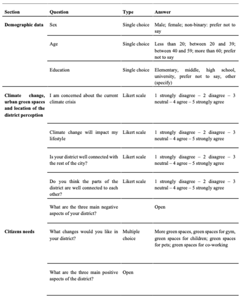
References
- Wissink, B.; van Kempen, R.; Fang, Y.; Li, S.-M. Introduction: Living in Chinese Enclave Cities. Urban Geography 2012, 33(2), 161–166. [Google Scholar] [CrossRef]
- Angotti, T. The New Century of the Metropolis: Urban Enclaves and Orientalism; Routledge: New York, NY, 2013. [Google Scholar]
- He, S. Evolving Enclave Urbanism in China and Its Socio-Spatial Implications: The Case of Guangzhou. Social and Cultural Geography 2013, 14(3), 243–2758. [Google Scholar] [CrossRef]
- Caldeira, T. Fortified Enclaves: The New Urban Segregation. Public Culture 1996, 8, 303–328. [Google Scholar] [CrossRef]
- Meninno, C. Enclavi commerciali trasformazioni architettoniche, urbane e territoriali. In The shopping center as/is a meeting place; Rodani V, M.C.E., Ed.; GECA Srl - San Giuliano Milanese (MI) per EUT Edizioni Universitarie Trieste, 2020; pp. 19–27. [Google Scholar]
- Eggermont, H.; Balian, E.; Azevedo JM, N.; Beumer, V.; Brodin, T.; Claudet, J.; Fady, B.; Grube, M.; Keune, H.; Lamarque, P.; Reuter, K.; Smith, M.; Van Ham, C.; Weisser, W.W.; Le Roux, X. Nature-based Solutions: New Influence for Environmental Management and Research in Europe. GAIA - Ecological Perspectives for Science and Society 2015, 24(4), 243–248. [Google Scholar] [CrossRef]
- Bai, X.; Dawson, R.J.; Urge-Vorsatz, D.; Delgado, G.C. Six research priorities for cities and climate change. Nature 2018. [CrossRef]
- Kabisch, N.; Qureshi, S.; Haase, D. Human–environment interactions in urban green spaces — A systematic review of contemporary issues and prospects for future research. Environmental Impact Assessment Review 2015, 50, 25–34. [Google Scholar] [CrossRef]
- Raymond, C.; Breil, M.; Nita, M.; Kabisch, N.; de Bel, M.; Enzi, V.; Frantzeskaki, N.; Geneletti, G.; Lovinger, L.; Cardinaletti, M.; Basnou, C.; Monteiro, A.; Robrecht, H.; Sgrigna, G.; Muhari, L.; Calfapietra, C.; Berry, P. An impact evaluation framework to support planning and evaluation of nature-based solutions projects. Report prepared by the EKLIPSE Expert Working Group on Nature-based Solutions to Promote Climate Resilience in Urban Areas. Centre for Ecology and Hydrology 2017. [Google Scholar]
- Egorov, A.I.; Mudu, P.; Braubach, M.; Martuzzi, M. (Eds.) Urban green spaces and health; WHO Regional Office for Europe: Copenhagen, 2016. [Google Scholar]
- Ugolini, F.; et al. Effects of the COVID-19 pandemic on the use and perceptions of urban green space: an international exploratory study. Urban forestry & Urban greening 2020, 56, 126888. Available online: https://www.sciencedirect.com/journal/urban-forestry-and-urban-greening/vol/56/suppl/C.
- Paradiso, M. Per una geografia critica delle «smart cities». Tra innovazione, marginalità, equità, democrazia, sorveglianza. Bollettino della Società Geografica Italiana 2013, XIII, VI, 679–693. [Google Scholar]
- Auci, S.; Mundula, L. La misura delle smart cities e gli obiettivi della strategia EU 2020: una riflessione critica. Geotema 2019, 59, 57–69. [Google Scholar]
- Rossi, M. Mobilità urbana e sostenibile tra innovazione e partecipazione (webinar, 21 maggio 2020). Semestrale di Studi e Ricerche di Geografia 2020, XXXII, 147–150. [Google Scholar]
- Vanolo, A. Smartmentality: the smart city as disciplinary strategy. Urban Studies 2014, 51, 883–898. [Google Scholar] [CrossRef]
- Siniscalchi, S. Smart City e governance del territorio. Le potenzialità degli opendata cartografici attraverso alcuni casi di studio. Bollettino della Associazione Italiana di Cartografia 2017, 160, 69–79. [Google Scholar]
- Nicolas, C.; Kim, J.; Chi, S. Natural language processing-based characterization of top-down communication in smart cities for enhancing citizen alignment. Sustainable Cities and Society 2021, 66, 1–15. [Google Scholar] [CrossRef]
- Cantrell, B.E.; Martin, L.J.; Ellis, E.C. Designing Autonomy: Opportunities for New Wildness in the Anthropocene. Trends in ecology & evolution 2017, 32, 156–166. [Google Scholar]
- DiSalvo, C.; Jenkins, T. Fruit are Heavy: A prototype public IoT system to support urban foraging. In Proceedings of the 2017 ACM Conference on Designing Interactive Systems; 2017. [Google Scholar]
- Blessi, G.T.; Grossi, E.; Sacco, P.L.; Pieretti, G.; Ferilli, G. The contribution of cultural participation to urban well-being. A comparative study in Bolzano/Bozen and Siracusa, Italy. Cities 2016, 50, 216–226. [Google Scholar] [CrossRef]
- Luvisi, A.; Lorenzini, G. RFID-plants in the smart city: Applications and outlook for urban green management. Urban Forestry and Urban Greening 13(4), 630–637. [CrossRef]
- Sandbrook, C.; Adams, W.M.; Monteferri, B. Digital Games and Biodiversity Conservation. 2015. [Google Scholar] [CrossRef]
- Guerrero, P.; Møller, M.S.; Olafsson, A.S.; Snizek, B. Revealing Cultural Ecosystem Services through Instagram Images: The Potential of Social Media Volunteered Geographic Information for Urban Green Infrastructure Planning and Governance. Urban Planning 2016, 1, 1–17. [Google Scholar] [CrossRef]
- Taylor Buck, N.; While, A. Competitive urbanism and the limits to smart city innovation: The UK Future Cities initiative. Urban Studies 2017, 54(2), 501–519. [Google Scholar] [CrossRef]
- Gabrys, J. A Cosmopolitics of Energy: Diverging Materialities and Hesitating Practices. Environment and Planning A 2014, 46(9), 2095–2109. [Google Scholar] [CrossRef]
- COM 2020 Biodiversity strategy for 2030, Biodiversity strategy for 2030 - European Commission (europa.eu).
- PNRR. Available online: https://www.governo.it/sites/governo.it/files/PNRR.
- Pozoukidou, G.; Chatziyiannaki, Z. 15-Minute City: Decomposing the New Urban Planning Eutopia. Sustainability 2021, 13(2), 928. [Google Scholar] [CrossRef]
- Khavarian-Garmsir, A.R.; Sharifi, A.; Hajian Hossein Abadi, M.; Moradi, Z. From Garden City to 15-Minute City: A Historical Perspective and Critical Assessment. Land 2023, 12(2), 512. [Google Scholar] [CrossRef]
- Fisch, J. Green Infrastructure and the Sustainability Concept: A Case Study of the Greater New Orleans Urban Water Plan. University of New Orleans Theses and Dissertations, 2014; p. 1869. [Google Scholar]
- Lefever, S.; Dal, M.; Matthíasdóttir, Á. Online data collection in academic research: Advantages and limitations. Br J Educ Technol 2007, 38, 574–582. [Google Scholar] [CrossRef]
- Baltar, F.; Brunet, I. Social research 2.0: Virtual snowball sampling method using Facebook. Internet Res 2012, 22, 57–74. [Google Scholar] [CrossRef]
- Daikeler, J.; Bošnjak, M.; Lozar Manfreda, K. Web versus other survey modes: An updated and extended meta-analysis comparing response rates. Journal of Survey Statistics and Methodology 2020, 8(3), 513–39. [Google Scholar] [CrossRef]
- Gioia, E.; Guadagno, E. Perception of climate change impacts, urbanization, and coastal planning in the Gaeta Gulf (central Tyrrhenian Sea): A multidimensional approach. AIMS Geosciences 2024, 10(1), 80–106. [Google Scholar] [CrossRef]
- Ahern, J. Planning for an extensive open space system: linking landscape structure and function. Landsc Urban Plan 1991, 21(1–2), 131–145. [Google Scholar] [CrossRef]
- Rudd, H.; Vala, J.; Schaefer, V. Importance of backyard habitat in a comprehensive biodiversity conservation strategy: a connectivity analysis of urban green spaces. Restor Ecol 2002, 10(2), 368–37. [Google Scholar] [CrossRef]
- Van Herzele, A.; Wiedemann, T. A monitoring tool for the provision of accessible and attractive urban green spaces. Landscape Urban Plan 2003, 63(2), 109–126. [Google Scholar] [CrossRef]
- Kong, F.; Yin, H.; Nakagoshi, N.; Zong, Y. Urban green space network development for biodiversity conservation: identifcation based on graph theory and gravity modeling. Landsc Urban Plan 2010, 95(1–2), 16–27. [Google Scholar] [CrossRef]
- Lee, A.C.; Maheswaran, R. The health benefts of urban green spaces: a review of the evidence. J Public Health 2011, 33(2), 212–222. [Google Scholar] [CrossRef]
- Van Dillen, S.M.; de Vries, S.; Groenewegen, P.P.; Spreeuwenberg, P. Greenspace in urban neighbourhoods and residents’ health: adding quality to quantity. J Epidemiol Community Health 2012, 66(6), e8. [Google Scholar] [CrossRef]
Figure 1.
San Bartolomeo district today. Source: Google Earth.
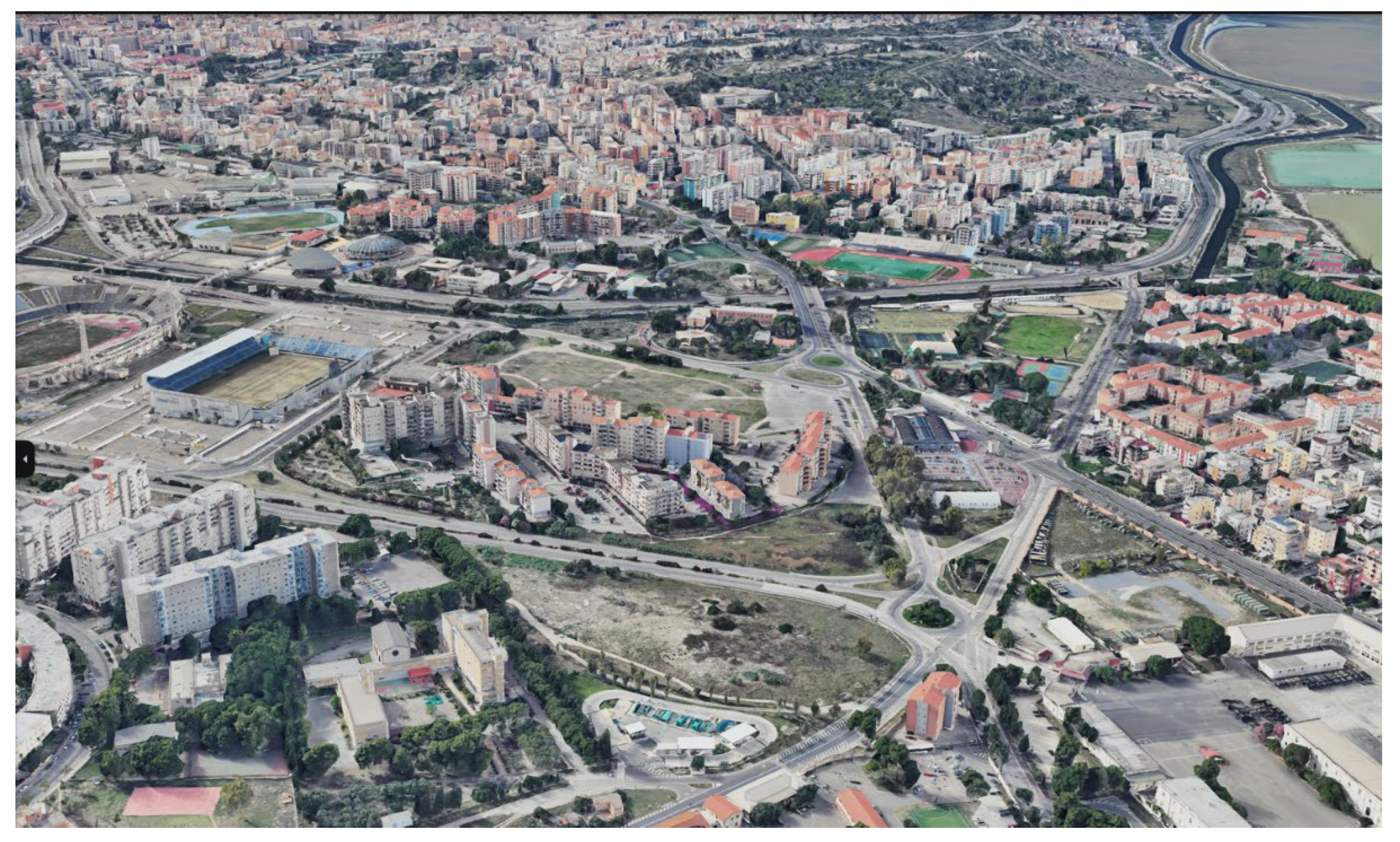
Figure 2.
Localization of Projects. Source: Author’s elaboration.
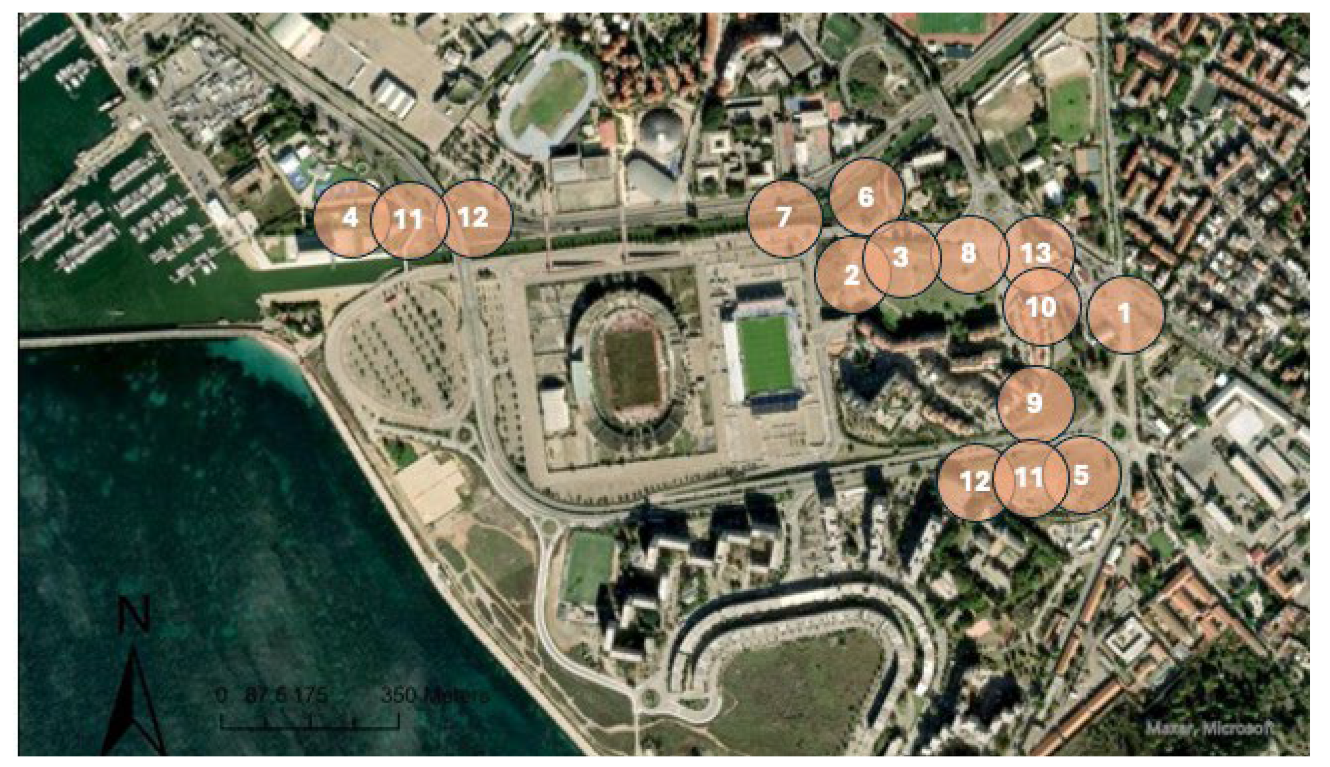
Figure 3.
The integrated scenario. Source: Elaboration by Ferdinando Manconi.
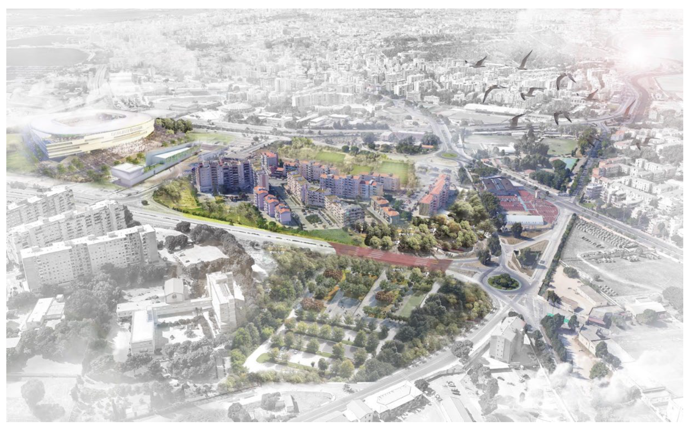
Disclaimer/Publisher’s Note: The statements, opinions and data contained in all publications are solely those of the individual author(s) and contributor(s) and not of MDPI and/or the editor(s). MDPI and/or the editor(s) disclaim responsibility for any injury to people or property resulting from any ideas, methods, instructions or products referred to in the content. |
© 2024 by the authors. Licensee MDPI, Basel, Switzerland. This article is an open access article distributed under the terms and conditions of the Creative Commons Attribution (CC BY) license (http://creativecommons.org/licenses/by/4.0/).
Copyright: This open access article is published under a Creative Commons CC BY 4.0 license, which permit the free download, distribution, and reuse, provided that the author and preprint are cited in any reuse.


