Submitted:
01 October 2024
Posted:
01 October 2024
You are already at the latest version
Abstract
The application of machine learning (ML) and remote sensing (RS) in soil and water conserva-tion has become a powerful tool. As analytical tools continue to advance, the variety of ML al-gorithms and RS sources has expanded, providing opportunities for more sophisticated analyses. At the same time, researchers are required to select appropriate technologies based on research objectives, topic, and scope of the study area. In this paper, we present a comprehensive review on the application of ML algorithms and RS that has been implemented to advance research in soil and water conservation. The key contribution of this review paper is that it provides an overview of current research areas within soil and water conservation and their effectiveness in improving prediction accuracy and resource management in categorized subfields, including biomass-vegetation, soil properties, hydrology and water resources, and wildfire management. We also highlight challenges and future directions based on limitations of ML and RS applica-tions in soil and water conservation. This review aims to serve as a reference for researchers and decision-makers by offering insights into the effectiveness of ML and RS applications in the field of soil and water conservation.
Keywords:
Machine learning
; Remote sensing
; Soil conservation
; Water conservation
; Environmental analysis
; Data-driven decision-making
; Resource management
1. Introduction
Soil and water play a pivotal role in various ecological processes, including nutrient cycling, water filtration, and habitat provision, which collectively support biodiversity and ecosystem stability. Soils contribute to the cycling of carbon, nitrogen, and phosphorus critical for plant growth and ecosystem productivity [1,2,3]. Water is essential for maintaining hydrological cycles, regulating temperature, and sustaining terrestrial and aquatic habitats [4,5]. These resources are fundamental to ecosystem resilience and functionality, impacting not only natural processes, but also human activities such as agriculture and urban development [6,7].
In addition to their ecological significance, soil and water resources are crucial for sustainable agricultural practices and food security [8]. However, their integrity is increasingly compromised by anthropogenic factors including climate change, population growth, deforestation, and unsustainable land use practices [9]. Climate change can exacerbate soil erosion, disrupt nutrient cycles, and affect water availability by altering precipitation patterns and increasing frequencies of extreme weather events [10]. Population growth and urban expansion place additional pressures on these resources, leading to overexploitation, pollution, and habitat loss [11]. Deforestation can further undermine soil structure and reduce land’s capacity to retain water, while poor land management practices can accelerate soil degradation and water contamination [12,13].
Addressing these challenges requires a comprehensive approach to soil and water conservation that encompasses a range of strategies aimed at mitigating negative effects of these stressors [14,15]. Effective soil conservation involves practices such as erosion control, moisture retention through irrigation management and organic amendments, and sustainable land use planning. Similarly, water conservation encompasses measures to enhance water quality, improve storage capacity, and promote efficient usage. These conservation practices are important not only for sustaining ecosystem health and agricultural productivity, but also for supporting broader environmental management goals, including wildfire mitigation and recovery. To address this, numerical models have traditionally been important tools in soil and water conservation [16,17]. However, their reliance on a limited set of variables and specific assumptions often results in prediction accuracy being heavily dependent on given input data [18,19,20,21]. Additionally, they may fail to account for uncertainties in the detection of climate change [18]. Thus, advanced tools that can complement or even replace traditional numerical models are needed. Integration of machine learning (ML) and remote sensing (RS) data presents a promising solution to limitations of traditional methods in soil and water conservation [22]. Advances in usage of RS data provide extensive spatial and temporal data, capturing environmental changes with high precision across large areas [23,24]. RS techniques such as multispectral and hyperspectral imaging, LiDAR, and synthetic aperture radar (SAR) enable the collection of data on various environmental parameters, including soil moisture, vegetation cover, land surface temperature, and water quality. When combined with ML techniques such as Random Forest (RF), Support Vector Machines (SVM), Convolutional Neural Networks (CNNs), and Gradient Boosting Machines (GBMs), these data can be analyzed to identify patterns, make predictions, and develop more effective conservation strategies. Combined with ML, these data can be analyzed to identify patterns of spatial and temporal data, make predictions, and establish more effective conservation strategies [25,26]. The ability of ML to process vast amounts of RS data enables extraction of valuable insights from complex, unstructured datasets, leading to improved accuracy in predicting soil and water resource changes. Additionally, the fusion of ML and RS allows for real-time monitoring and assessment, offering dynamic and responsive tools for decision-making in conservation practices [27,28]. This integrated approach can enhance resource optimization, increase precision of policy implementations, and facilitate data-driven decision-making in soil and water management.
The objective of this review is to explore the potential of ML and RS technologies in advancing soil and water conservation. This review aims to provide an overview of current research areas within soil and water conservation and to present how a combination of ML and RS can overcome limitations of traditional methods. The review will highlight applications of various ML techniques and RS data in different subfields of soil and water conservation, demonstrating their effectiveness in improving prediction accuracy and resource management. Additionally, this paper will discuss future research directions, focusing on integrating ML with RS and development of innovative solutions for sustainable soil and water conservation. The scope includes a detailed examination of how these advanced tools can be applied across diverse conservation challenges and implications for future policy and practice.
2. Materials and Methods
2.1 Searching/Classification Methodology
The literature review focused on collecting published journals that applied ML algorithms and RS data to conduct research related to soil and water conservation, as summarized in Figure 1.
To identify relevant publications, we utilized the web-based bibliographic database ‘ScienceDirect’ to identify relevant publications, using specific keywords such as “machine learning,” “remote sensing,” “soil conservation,” and “water conservation”. This search resulted in the identification of 200 studies conducted across 47 countries, as shown in Figure 2. Studies conducted in China, the United States, and Iran, with smaller but notable frequencies in Australia, Canada, Russia, and several European countries showed the highest frequencies. Studies conducted in other locations around the world, including parts of Africa, South America, and South Asia, were also marked, indicating their relative frequency in the data. Figure 3 illustrates trends in reviewed publications across four key research areas from 2006 to 2024. Wildfire management exhibited a dramatic increase in publications, peaking in 2022, likely due to the increasing impact of climate change, advances in ML and RS technologies, and increased global awareness driven by initiatives such as the UN’s SDGs and the Paris Agreement. Research studies on soil properties, hydrology, and water resources also peaked around the same time, although they showed a more gradual rise and fall. Frequency of research on biomass-vegetation remained relatively low in comparison, with minimal fluctuations throughout the period.
Research subjects of 200 studies were then identified and categorized into a total of 37 specific research topics, referred to as “subcategorized subjects,” including above-ground biomass, grassland biomass, ground biomass, soil conductivity, soil salinity, soil organic carbon (SOC), soil aggregate stability, soil chemistry, soil degradation, soil erodibility, soil matric potential, soil mercury, soil moisture, soil nutrients, soil total nitrogen, soil respiration, soil stiffness, soil texture, soil types, soil organic matter, soil water content and evapotranspiration, groundwater level, streamflow, surface water, water storage, sediment concentration, algal blooms, Secchi disk depth, sediment discharge, water quality, turbidity, evapotranspiration, flash flood water depth, inundation status, ocean surface CO2, wildfire prediction, wildfire monitoring, and wildfire recovery as shown in Table 1. These subcategorized subjects were then reclassified into four research fields: 1) biomass-vegetation, 2) soil properties, 3) hydrology and water resources, and 4) wildfire management. While some subcategorized subjects of collected studies were closely related and ambiguous to distinguish, the classification focused on the objective of this study. The research field of soil properties had the highest number of publications, followed by wildfire management, hydrology and water resources, and biomass-vegetation research fields. Publications were distributed as follows: 93 (47%) papers on soil properties, 52 (26%) papers on wildfire management, 50 (25%) papers on hydrology and water resources, and 5 (2%) papers on biomass-vegetation as shown in Figure 4.
3. Results and Discussion
3.1. Types and Frequencies of RS Data Used in Soil and Water Conservation Research
Of 200 studies collected, a total of 41 different types of RS techniques were identified (Table A2). Figure 5 depicts the number of publications that utilized each RS data, highlighting only those RS data used more than twice across the 200 studies. The following RS data were used only once each: AGRS, ALOS-2, AVIRIS-NG, GF-1, Triplesat, PALSAR-2, Terra, ZH-1, ETM+, SVC, SRTM, NLCD, Himawari-8, TDC, AMSR-E, MERIS, MERRA-2, Chinese Environmental 1A satellite, GOES-16, TM, SAR, and SPOT-4. This study analyzed types and frequencies of RS data used across different research fields in soil and water conservation. RS data were classified based on four research fields. Below is an overview of the most frequently used RS data types within each field. Table 3 summarizes the number of publications and the top three most commonly used RS data in different environmental research fields, including biomass-vegetation, soil properties, hydrology and water resources, and wildfire management. In the field of biomass-vegetation, MODIS and UAVs were the most commonly used algorithms, appearing two times. These tools are crucial for large-scale biomass estimation and vegetation monitoring. For Soil Properties, Landsat 8 was the most frequently used (32 times). Its high-resolution images and multispectral capabilities are particularly effective for evaluating soil characteristics. In hydrology and water resources, Landsat 8 was again predominant. It was used 18 times for tracking changes in water bodies, flood monitoring, and resource management. Lastly, in wildfire management, MODIS was the leading algorithm. It was used 20 times, offering vital support for real-time fire monitoring and management across damaged areas.
Landsat and MODIS are essential satellite sensors, each suitable for specific research applications due to differences in data characteristics and resolution. Landsat 8, Sentinel-2, and MODIS are frequently used in soil and water resource studies due to their technical features. Landsat, with its high spatial resolution of 30 meters, is ideal for detailed studies of soil characteristics and hydrology. It allows for precise analysis of small-scale features such as soil moisture and water flow. In contrast, MODIS with a lower resolution of 250 to 1,000 meters but a higher revisit frequency of twice daily is better suited for monitoring large-scale, rapidly changing events like wildfires. MODIS is particularly effective for wildfire management due to its ability to capture wide areas quickly and detect heat through infrared bands, while Landsat’s detailed imagery is preferred for soil and hydrological research.
These RS data also provide broad spatial and temporal coverage. MODIS collects global data daily, while Landsat 8 and Sentinel-2 offer high-resolution imagery with revisit periods of 16 days and 5 days, respectively. This allows for long-term monitoring of environmental changes and time-series analysis of hydrological events or soil changes. Moreover, these RS data offer long-term historical datasets, which is a significant advantage. For instance, the Landsat program has been accumulating data since the 1970s, making it valuable for analyzing decades of environmental changes or soil erosion patterns. Similarly, Sentinel-2 and MODIS provide consistent datasets over the years, supporting accurate trend analysis and modeling. The preference for these applications reflects their efficiency in capturing crucial information for soil and water resource conservation.
3.2. Types and Frequencies of ML Algorithm Used in Soil and Water Conservation Research
A total of 50 distinct ML algorithms were identified and their usage frequencies are illustrated in Figure 6. Algorithms that appeared more than twice are shown, while those not depicted to prevent excessive clutter, each used only once, include RTM, ANFIS, ARD, BAGGING, BDT, SA, SCA-Elman, SoLIM, SOM, SR, PSO-SVR, B-CART, CBR, DR, DELM, GAN, BAYE, LGBM, GSC, GRNN, PCR, PKR, RPART, MR-CNN, LMM, EBP, ETR, ELR, EM, EFS, EPR, DBN, DRF, DMP, LDA, MDN, MLPR, MT, Nue-SICR, SICR, FR, FCN, FNN, AdaBag, BST, M5P, YOLO, and IF. The number of publications across research fields related to RS data and the top three most commonly used algorithms along with their frequency of usage is shown in Table 4. In the biomass-vegetation field, RF and ANN were used most frequently. The Soil properties field had the highest number of publications, with RF being the most prevalent algorithm. Similarly, hydrology and water resources and wildfire management also showed a preference for RF as the leading algorithm. In cases where algorithms were used with the same frequency, they were ranked equally. The total number of algorithm usages does not necessarily match the total number of publications due to the use of multiple algorithms in some studies.
RF, ANN, and SVM were the most commonly used ML algorithms across different research fields. RF is an ensemble learning method that constructs multiple decision trees during training and aggregates their outputs for prediction. This approach enhances accuracy and mitigates overfitting by averaging results of numerous trees, which can help manage noisy and high-dimensional datasets common in environmental research. RF is frequently used in environmental research due to its effectiveness in identifying feature importance, which helps researchers determine the most influential variables affecting environmental processes such as water quality prediction [143,156] and land cover classification[80] . Its robustness and capacity to manage large datasets enhance its utility across various ecological and hydrological applications. ANNs excel at modeling complex, non-linear relationships capturing intricate data patterns. Comprised of interconnected neurons that can adjust weights through iterative training, ANNs can optimize predictions for complex environmental variables. This adaptability makes them highly effective for tasks such as flood prediction and groundwater level forecasting, where capturing non-linear interactions is essential. Their ability to generalize from extensive datasets ensures precise modeling of dynamic environmental systems. This adaptability makes ANNs particularly useful for tasks such as flood prediction or groundwater level forecasting, where capturing non-linear interactions is crucial. Their capability to generalize from extensive training datasets enables accurate modeling of dynamic environmental systems and phenomena.
3.3 Field-Specific Observations
3.3.1. Biomass-Vegetation
In the research field of biomass and vegetation, researchers frequently combine MODIS and UAV data with ML algorithms such as RF and ANN to assess vegetation conditions and estimate biomass. MODIS is effective for large-scale vegetation monitoring and tracking seasonal changes and long-term trends due to its global coverage and frequent revisit times. UAV, on the other hand, provides high spatial resolution and flexibility, capturing detailed images at plot or landscape levels. Equipped with sensors like RGB cameras, multispectral, hyperspectral, and LiDAR, UAVs can be utilized to detect specific wavelengths that indicate plant health, structure, and biomass. RF is particularly useful for managing large datasets and modeling complex relationships between spectral data and vegetation attributes such as Leaf Area Index (LAI), chlorophyll content, and biomass density.
3.3.2. Soil Properties
In the research field of soil properties, numerous studies have combined RS data from Landsat 8 and Sentinel-2 with RF. Landsat 8 and Sentinel-2 are widely utilized for mapping and monitoring soil properties at regional and global scales due to their high-resolution multispectral imagery. These satellites provide data that can be used to derive indicators related to soil properties such as organic carbon content, soil moisture, and soil texture. ML algorithms such as RF and SVM are particularly effective in this field because they can handle large and complex datasets and model nonlinear relationships between RS-derived variables and soil attributes. RF is especially useful for processing large amounts of data and analyzing complex patterns that link spectral information with soil properties, while SVM is often employed to classify and predict soil properties by maximizing the margin between different types of soil data. The integration of RS data and ML algorithms enables more accurate and efficient prediction and mapping of soil characteristics, which is essential for sustainable land management, agriculture, and environmental conservation.
3.3.3. Hydrology and Water Resources
In the research field of hydrology and water resources, studies have mainly focused on predicting river flow, groundwater levels, and water quality parameters. RS data from Landsat 8 and Sentinel-2 have been widely used due to their ability to capture detailed spatial and temporal information related to water bodies and terrain. These satellites can provide high-resolution multispectral imagery that is crucial for monitoring and assessing various hydrological variables such as surface water extent, vegetation cover, and soil moisture, which can directly influence hydrological processes. In this field, RF and SVR are preferred for modeling complex and nonlinear hydrological processes due to their robustness and accuracy. RF has been utilized to process large datasets and identify patterns in river flow and groundwater levels, while SVR has been employed to predict continuous variables such as water quality parameters, leveraging its ability to model relationships in data with limited observations. The combination of RS data from Landsat 8 and Sentinel-2 with ML algorithms such as RF and SVR can enhance the ability to accurately predict and manage water resources, which is essential for sustainable water resource management and planning.
3.3.4. Wildfire Management
In the research field of wildfire management, ML techniques are extensively used to predict and monitor wildfire occurrences. MODIS, known for its daily global coverage, is one of the most frequently utilized RS data sources in this domain. MODIS provides critical information for real-time monitoring and historical analysis of wildfires, enabling the detection of active fires, mapping of burn scars, and assessment of the extent of fire-affected areas. Its frequent revisit times are particularly useful for tracking wildfire progression and immediate impacts. To predict fire-prone areas and assess post-fire effects on soil and vegetation, MODIS data are commonly used with RF and SVM. RF is highly effective in identifying complex patterns among environmental variables, such as vegetation type, moisture content, and weather conditions, which can influence wildfire risk. SVM is also employed to classify regions based on fire vulnerability and to assess the severity of fires within ecosystems. The integration of MODIS data with ML algorithms such as RF and SVM can enhance the ability to predict wildfires, mitigate risks, and manage post-fire recovery efforts, contributing to more effective wildfire management strategies.
4. Challenges and Limitations
4.1. Data-Related Challenges
One of the fundamental challenges in the application of ML to soil and water conservation lies in the availability, quality, and consistency of RS data. RS data are often characterized by varying spatial, spectral, and temporal resolutions, which can introduce significant variability into datasets used for model training and validation. For instance, while Landsat can provide data with moderate (15 ~ 120 m) spatial resolution and a long temporal record, Sentinel-2 offers higher spatial resolution (10 ~ 60 m) but with a shorter historical dataset. The integration of these diverse data sources can be problematic, as differences in resolution, sensor characteristics, and data acquisition periods can lead to discrepancies that need to be harmonized. In addition, inconsistent or incomplete datasets are a common issue, particularly in regions with limited historical monitoring or where cloud cover frequently obstructs satellite observations. These data gaps can introduce biases into ML models, leading to inaccurate results for prediction. For example, if training data are not representative of the full range of environmental conditions, the model may fail to generalize effectively, resulting in poor performance when applied to new or unseen conditions. Moreover, preprocessing of RS data, including tasks such as georeferencing, atmospheric correction, and resampling to a common spatial and temporal grid, can be technically demanding and resource-intensive. Harmonization of data from multiple sensors requires advanced techniques, such as data fusion and cross-calibration, to ensure consistency of inputs for ML models.
4.2. Technological Limitations
The implementation of ML in the context of soil and water conservation is often constrained by availability of computational resources and inherent complexity of algorithms employed. High-dimensional datasets—characterized by a large number of variables and extensive temporal records—are common in environmental studies. Processing these datasets requires significant computational power, including high-performance computing (HPC) clusters or cloud-based solutions, which may not be readily available in all research settings. The storage of such large volumes of data also poses challenges, as traditional data storage solutions might be insufficient to handle the scale and complexity of RS data. Furthermore, the complexity of ML algorithms—particularly those involving deep learning (e.g., convolutional neural networks, recurrent neural networks)—requires not only computational resources, but also specialized expertise. Deep learning models, for instance, often involve a large number of hyperparameters and require extensive tuning to achieve optimal performances. This complexity can be a significant barrier to the adoption of ML in resource-limited settings, where access to both infrastructure and skilled personnel might be limited. Model interpretability is another a significant concern in environmental applications. Many ML models, especially those classified as “black-box” models, offer limited insights into the underlying decision-making processes, which can hinder their acceptance and use in policy-making or by stakeholders. Decision-makers often require not only accurate predictions, but also an understanding of the rationale, which can be challenging to provide with complex ML models. Finally, the scalability limits the broader applicability of ML models across diverse geographic regions with availability constraints.
4.3. Implementation Issues
The practical application of ML in conservation efforts is also limited by challenges in model interpretation and transparency. Many ML techniques, particularly deep learning models, operate as “black boxes,” making it difficult for stakeholders to understand the decision-making process. This lack of interpretability can hinder the integration of ML outcomes into policy and management strategies.
5. Future Directions and Research Opportunities
Future research on ML for soil and water conservation will benefit from advancements in big data analytics and cloud computing, which can address current limitations related to data processing and storage. The development of more interpretable ML models, such as explainable AI (XAI), is also expected to enhance the integration of ML into decision-making, making outputs more accessible to non-experts. There is also a growing need for research that focuses on the development of hybrid models that can strength various ML algorithms and RS data to enhance prediction accuracy and provide a comprehensive understanding of soil and water processes. Such approaches can improve prediction accuracy and provide a more holistic understanding of environmental processes. Additionally, research should explore the potential of integrating ground-based sensor networks with RS data, enhancing real-time monitoring and predictive capabilities. The adoption of ML in soil and water conservation has significant policy implications, particularly in the context of climate change adaptation and sustainable land management. Future research should emphasize the importance of interdisciplinary collaboration, bringing together experts in ML, environmental science, and policy to ensure that technological advancements can translate into practical conservation outcomes. Collaborative efforts should also focus on capacity-building initiatives to equip stakeholders with necessary skills and knowledge to implement ML-driven solutions effectively.
The selection of algorithms in each field is influenced by characteristics of the data, complexity of the problem, and objectives of the prediction. RF is popular in many environmental and resource management fields due to its ability to handle complex interactions among variables and manage nonlinearity effectively. SVM is useful for high-dimensional data or problems with nonlinear boundaries. Meanwhile, ANN and MLP excel at learning complex nonlinear patterns. The choice of these algorithms is made to optimize outcomes based on characteristics of the data and goals of problem-solving. The selection of ML algorithms varies depending on factors such as data characteristics, problem complexity, and interpretability. Future research should focus on optimizing algorithm selection and improvement by considering these factors. Additionally, comparing performances of various algorithms and conducting comprehensive evaluations will be crucial for proposing the most suitable methodologies for each field, offering significant insights into best practices.
Author Contributions
“Conceptualization, Jang, W.S., Yun, Y.J.; methodology, Jang, W.S., Kim,Y.I., and Park, W.H.; validation, Jang, W.S., Park, W.H., Shin, Y.; formal analysis, Yun, Y.J.; investigation, Park, W.H.; resources, Shin, Y.; writing—original draft preparation, Kim, Y.I.; writing—review and editing, Kim, Y.I., Park, W.H., Engel, B.; visualization, Kim, Y.I.; supervision, Jang, W.S., Yun, Y.J.; project administration, Jang. W.S.; funding acquisition, Jang, W.S. All authors have read and agreed to the published version of the manuscript.”
Funding
“This study was supported by the research project, Developing of S-P-C experts for field-adaptive forest fire management (S: Smart, P: Professional, C: Confluence) (RS-2024-00402624), funded by the Korea Forest Service.”
Data Availability Statement
The data used in this study are contained within the article. Additional data are available upon request from the corresponding author.
Conflicts of Interest
“The authors declare no conflicts of interest.”
Appendix A

Table A1.
A list of all the abbreviated ML algorithms used in the paper.
| ML | Full of name |
|---|---|
| ABR | Adaptive Boosting Regression |
| AdaBag | Boosting and Bagging |
| AdaBoost | Boosted Classifier |
| ANFIS | Adaptive Neuro Fuzzy Inference System |
| ANN | Artificial Neural Network |
| ARD | Automatic Relevance Determination |
| BAGGING | Bootstrap Aggregating Regression |
| BAYE | Bayesian |
| B-CART | Bagged Classification and Regression Trees |
| BDT | Bagging Decision Tree |
| BPNN | Back Propagation Neural Network |
| BRTs | Boosted Regression Trees |
| BST | Extreme Gradient Boosting Tree |
| CART | Classification and Regression Trees |
| CB | Cubist |
| CBR | Catboost Regression |
| CNN | Convolutional Neural Network |
| DBN | Deep Belief Network |
| DELM | Deep Extreme Learning Machine |
| DL | Deep Learning |
| DMP | Dense Multilayer Perceptron |
| DNN | Deep Neural Networks |
| DR | Dmine Regression |
| DRF | Distributed Random Forest |
| DTr | Decision Tree |
| EBP | Error Back Propagation |
| EFS | Exhaustive Feature Selection |
| ELM | Extreme Learning Machine |
| ELR | Extreme Learning Machine Regression |
| EM | Evaluation metrics |
| EN | Elastic Net |
| EPR | Evolutionary Polynomial Regression |
| ERT | Extremely Randomized Tree |
| ETR | Extreme Tree Regression |
| FCN | Fully Connected Network |
| FNN | Feed forward Neural Networks |
| FR | Frequency Ratio |
| GAN | Generative Adversarial Networks |
| GB | Gradient Boosting |
| GBDT | Gradient Boosted Decision Tree |
| GBM | Gradient Boosting Machine |
| GBR | Gradient Boosting Regression |
| GBRT | Gradient Boosting Regression Tree |
| GEP | Genetic Expression Programming |
| GLM | Generalized Linear Model |
| GPR | Gaussian Process Regression |
| GRNN | General Regression Neural Network |
| GSC | Generalized Synthetic Control |
| Isolation Forest | Isolation Forest |
| KNN | K-nearest Neighbors |
| La-R | Lasso Regression |
| LARS | Least Angle Regression |
| LDA | Linear Discriminant Analysis |
| LGBM | Light Gradient Boosting Machine |
| Li-R | Linear Regression |
| LMM | Linear Mixed-Effects Model |
| Lo-R | Logistic Regression |
| LSTM | Long Short-Term Memory |
| M5P | M5-pruned |
| MARS | Multivariate Adaptive Regression Spline |
| MaxEnt | Maximum Entropy Model |
| MDN | Mixture Density Network |
| MLP | Multilayer Perceptron |
| MLPR | Multi-Layer Perceptron Regression |
| MLR | Multiple Linear Regression |
| MR-CNN | Mask Region-Based Convolutional Neural Network |
| MT | M5 Model Tree |
| NB | Naïve Bayes |
| Neu-SICR | Neural Network-Satellite and In situ sensor Collaborated Reconstruction |
| NN | Neural Networks |
| NNET | Feed-Forward Neural Network |
| OLS | Ordinary Least Squares |
| PCR | Principal Component Regression |
| PKR | Polynomial Kernel Regression |
| PLS | Partial Least Squares |
| PLSR | Partial Least Squares Regression |
| PSO-SVR | Particle Swarm Optimization and Support Vector Machine |
| QR | Quantile Regression Forest |
| RBFN | Radial Basin Function Neural Network |
| RF | Random Forest |
| RNN | Recurrent Neural Network |
| RPART | Recursive Partitioning and Regression Trees |
| RR | Ridge Regression |
| RT | Regression Tree |
| RTM | Radiative Transfer Models |
| RVR | Relevance Vector Regression |
| SA | Sensitivity Analysis |
| SCA-Elman | Sine Cosine Algorithm-Elman |
| SGB | Stochastic Gradient Boosting |
| SICR | Sensor Collaborated Reconstruction |
| SLR | Stepwise Linear Regression |
| SoLIM | Soil–Landscape Inference Model (Fuzzy logic) |
| SOM | Self-Organizing Maps |
| SR | Simple Regression |
| SVM | Support Vector Machine |
| SVR | Support Vector Regression |
| XGB | EXtreme Gradient Boosting |
| XGBR | Extreme Gradient Boosting Regression |
| YOLO | You Only Look Once |
Table A2.
Descriptions for RS techniques implemented in reviewed publications. In the description of RS techniques related to satellites, the resolution, launching entity, and key features were included. Note: Each asterisk level corresponds to a specific category (*Satellite name, ** Resolution of satellite, *** Launching entity, and **** Key features).
| RS Techniques | Descriptions | |
|---|---|---|
| Satellite | ALOS-2* |
|
| Chinese Environmental 1A |
|
|
| GF-1 |
|
|
| GOES-16 |
|
|
| Himawari-8 |
|
|
| Landsat 4, 5 |
|
|
| Landsat 7 |
|
|
| Landsat 8, 9 |
|
|
| RADARSAT |
|
|
| RapidEye |
|
|
| Sentitel-1 |
|
|
| Sentitel-2 |
|
|
| Sentitel-3 |
|
|
| SMAP |
|
|
| SPOT-4 |
|
|
| SPOT-7 |
|
|
| SRTM |
|
|
| Terra |
|
|
| Triplesat |
|
|
| WorldView-3 |
|
|
| ZH-1 |
|
|
| AGRS |
|
|
| AMSR-E |
|
|
| AVIRIS-NG |
|
|
| ETM+ |
|
|
| Thermal infrared |
|
|
| Leica ADS80 |
|
|
| LiDAR |
|
|
| MERIS |
|
|
| MODIS |
|
|
| PALSAR-2 |
|
|
| SAR |
|
|
| SVC |
|
|
| TDC |
|
|
| Hyperspectral Imager |
|
|
| TM |
|
|
| UAS / UAV |
|
|
| VIIRS |
|
|
References
Disclaimer/Publisher’s Note: The statements, opinions and data contained in all publications are solely those of the individual author(s) and contributor(s) and not of MDPI and/or the editor(s). MDPI and/or the editor(s) disclaim responsibility for any injury to people or property resulting from any ideas, methods, instructions or products referred to in the content.
- Pereira, P. , et al., Soil ecosystem services, sustainability, valuation and management. Current Opinion in Environmental Science & Health, 2018. 5: p. 7-13.
- Trap, J.; Bonkowski, M.; Plassard, C.; Villenave, C.; Blanchart, E. Ecological importance of soil bacterivores for ecosystem functions. Plant Soil 2015, 398, 1–24. [Google Scholar] [CrossRef]
- Whitford, W.G. The importance of the biodiversity of soil biota in arid ecosystems. Biodivers. Conserv. 1996, 5, 185–195. [Google Scholar] [CrossRef]
- Allan, R.P.; Barlow, M.; Byrne, M.P.; Cherchi, A.; Douville, H.; Fowler, H.J.; Gan, T.Y.; Pendergrass, A.G.; Rosenfeld, D.; Swann, A.L.S.; et al. Advances in understanding large-scale responses of the water cycle to climate change. Ann. New York Acad. Sci. 2020, 1472, 49–75. [Google Scholar] [CrossRef] [PubMed]
- Peixoto, J.P.; Kettani, M.A. The Control of the Water Cycle. Sci. Am. 1973, 228, 46–61. [Google Scholar] [CrossRef]
- Lal, R. , Soil conservation and ecosystem services. International soil and water conservation research, 2014. 2(3): p. 36-47.
- Neary, D.G.; Ryan, K.C.; DeBano, L.F. Wildland Fire in Ecosystems: Effects of Fire on Soils and Water, General Technical Report RMRSGTR-42-Vol.4; USDA, Forest Service, Rocky Mountain Research Station: Ogden, UT, USA, 2005. [Google Scholar]
- Ali, M.; Talukder, M. Increasing water productivity in crop production—A synthesis. Agric. Water Manag. 2008, 95, 1201–1213. [Google Scholar] [CrossRef]
- Akhtar, N.; Ishak, M.I.S.; Bhawani, S.A.; Umar, K. Various Natural and Anthropogenic Factors Responsible for Water Quality Degradation: A Review. Water 2021, 13, 2660. [Google Scholar] [CrossRef]
- Bungau, S.; Behl, T.; Aleya, L.; Bourgeade, P.; Aloui-Sossé, B.; Purza, A.L.; Abid, A.; Samuel, A.D. Expatiating the impact of anthropogenic aspects and climatic factors on long-term soil monitoring and management. Environ. Sci. Pollut. Res. 2021, 28, 30528–30550. [Google Scholar] [CrossRef]
- Zhang, X.; Chen, J.; Tan, M.; Sun, Y. Assessing the impact of urban sprawl on soil resources of Nanjing city using satellite images and digital soil databases. CATENA 2006, 69, 16–30. [Google Scholar] [CrossRef]
- Hajabbasi, M.A.; Jalalian, A.; Karimzadeh, H.R. Deforestation effects on soil physical and chemical properties, Lordegan, Iran. Plant Soil 1997, 190, 301–308. [Google Scholar] [CrossRef]
- Syamsih, D. , Impacts of Deforestation on Soil Quality and Water Resources in Tropical Forest Areas of Sumatra. Journal of Horizon, 2024. 1(1): p. 16-22.
- Blanco-Canqui, H.; Lal, R. Principles of Soil Conservation and Management; Springer Nature: Dordrecht, GX, Netherlands, 2010. [Google Scholar]
- Côté, I.M.; Darling, E.S.; Brown, C.J. Interactions among ecosystem stressors and their importance in conservation. Proc. R. Soc. B: Biol. Sci. 2016, 283, 20152592. [Google Scholar] [CrossRef]
- Gassman, P.W.; Reyes, M.R.; Green, C.H.; Arnold, J.G. The Soil and Water Assessment Tool: Historical Development, Applications, and Future Research Directions. Trans. ASABE 2007, 50, 1211–1250. [Google Scholar] [CrossRef]
- Mansell, R. , et al., Adaptive grid refinement in numerical models for water flow and chemical transport in soil: a review. Vadose Zone Journal, 2002. 1(2): p. 222-238.
- Kattenberg, A. , et al., Climate models: projections of future climate, in Climate Change 1995: the science of climate change. Contribution of WG1 to the Second Assessment Report of the IPCC. 1996, Cambridge University Press. p. 299-357.
- Kavetski, D., S. W. Franks, and G. Kuczera, Confronting input uncertainty in environmental modelling. Calibration of watershed models, 2003. 6: p. 49-68.
- Matott, L.S.; Babendreier, J.E.; Purucker, S.T. Evaluating uncertainty in integrated environmental models: A review of concepts and tools. Water Resour. Res. 2009, 45. [Google Scholar] [CrossRef]
- Refsgaard, J.C.; van der Sluijs, J.P.; Højberg, A.L.; Vanrolleghem, P.A. Uncertainty in the environmental modelling process – A framework and guidance. Environ. Model. Softw. 2007, 22, 1543–1556. [Google Scholar] [CrossRef]
- Zhong, S.; Zhang, K.; Bagheri, M.; Burken, J.G.; Gu, A.; Li, B.; Ma, X.; Marrone, B.L.; Ren, Z.J.; Schrier, J.; et al. Machine Learning: New Ideas and Tools in Environmental Science and Engineering. Environ. Sci. Technol. 2021, 55, 12741–12754. [Google Scholar] [CrossRef]
- Huang, C.; Chen, Y.; Zhang, S.; Wu, J. Detecting, Extracting, and Monitoring Surface Water From Space Using Optical Sensors: A Review. Rev. Geophys. 2018, 56, 333–360. [Google Scholar] [CrossRef]
- Rogan, J.; Chen, D. Remote sensing technology for mapping and monitoring land-cover and land-use change. Prog. Plan. 2004, 61, 301–325. [Google Scholar] [CrossRef]
- Florath, J.; Keller, S. Supervised Machine Learning Approaches on Multispectral Remote Sensing Data for a Combined Detection of Fire and Burned Area. Remote. Sens. 2022, 14, 657. [Google Scholar] [CrossRef]
- Sun, A.Y.; Scanlon, B.R. How can Big Data and machine learning benefit environment and water management: a survey of methods, applications, and future directions. Environ. Res. Lett. 2019, 14, 073001. [Google Scholar] [CrossRef]
- Glasgow, H.B.; Burkholder, J.M.; Reed, R.E.; Lewitus, A.J.; Kleinman, J.E. Real-time remote monitoring of water quality: A review of current applications, and advancements in sensor, telemetry, and computing technologies. J. Exp. Mar. Biol. Ecol. 2004, 300, 409–448. [Google Scholar] [CrossRef]
- Wang, S.; Guan, K.; Zhang, C.; Lee, D.; Margenot, A.J.; Ge, Y.; Peng, J.; Zhou, W.; Zhou, Q.; Huang, Y. Using soil library hyperspectral reflectance and machine learning to predict soil organic carbon: Assessing potential of airborne and spaceborne optical soil sensing. Remote. Sens. Environ. 2022, 271. [Google Scholar] [CrossRef]
- Han, L.; Yang, G.; Dai, H.; Xu, B.; Yang, H.; Feng, H.; Li, Z.; Yang, X. Modeling maize above-ground biomass based on machine learning approaches using UAV remote-sensing data. Plant Methods 2019, 15, 1–19. [Google Scholar] [CrossRef] [PubMed]
- Sharma, P.; Leigh, L.; Chang, J.; Maimaitijiang, M.; Caffé, M. Above-Ground Biomass Estimation in Oats Using UAV Remote Sensing and Machine Learning. Sensors 2022, 22, 601. [Google Scholar] [CrossRef] [PubMed]
- Quang, N.H.; Quinn, C.H.; Carrie, R.; Stringer, L.C.; Van Hue, L.T.; Hackney, C.R.; Van Tan, D. Comparisons of regression and machine learning methods for estimating mangrove above-ground biomass using multiple remote sensing data in the red River Estuaries of Vietnam. Remote. Sens. Appl. Soc. Environ. 2022, 26, 100725. [Google Scholar] [CrossRef]
- Ali, I.; Cawkwell, F.; Dwyer, E.; Green, S. Modeling Managed Grassland Biomass Estimation by Using Multitemporal Remote Sensing Data—A Machine Learning Approach. IEEE J. Sel. Top. Appl. Earth Obs. Remote. Sens. 2016, 10, 3254–3264. [Google Scholar] [CrossRef]
- Meng, B.; Liang, T.; Yi, S.; Yin, J.; Cui, X.; Ge, J.; Hou, M.; Lv, Y.; Sun, Y. Modeling Alpine Grassland Above Ground Biomass Based on Remote Sensing Data and Machine Learning Algorithm: A Case Study in East of the Tibetan Plateau, China. IEEE J. Sel. Top. Appl. Earth Obs. Remote. Sens. 2020, 13, 2986–2995. [Google Scholar] [CrossRef]
- Lendzioch, T.; Langhammer, J.; Vlček, L.; Minařík, R. Mapping the Groundwater Level and Soil Moisture of a Montane Peat Bog Using UAV Monitoring and Machine Learning. Remote. Sens. 2021, 13, 907. [Google Scholar] [CrossRef]
- Saygın, F.; Aksoy, H.; Alaboz, P.; Dengiz, O. Different approaches to estimating soil properties for digital soil map integrated with machine learning and remote sensing techniques in a sub-humid ecosystem. Environ. Monit. Assess. 2023, 195, 1–21. [Google Scholar] [CrossRef]
- Rezaei, M.; Mousavi, S.R.; Rahmani, A.; Zeraatpisheh, M.; Rahmati, M.; Pakparvar, M.; Mahjenabadi, V.A.J.; Seuntjens, P.; Cornelis, W. Incorporating machine learning models and remote sensing to assess the spatial distribution of saturated hydraulic conductivity in a light-textured soil. Comput. Electron. Agric. 2023, 209. [Google Scholar] [CrossRef]
- Jia, P.; Zhang, J.; He, W.; Hu, Y.; Zeng, R.; Zamanian, K.; Jia, K.; Zhao, X. Combination of Hyperspectral and Machine Learning to Invert Soil Electrical Conductivity. Remote. Sens. 2022, 14, 2602. [Google Scholar] [CrossRef]
- Wang, N.; Xue, J.; Peng, J.; Biswas, A.; He, Y.; Shi, Z. Integrating Remote Sensing and Landscape Characteristics to Estimate Soil Salinity Using Machine Learning Methods: A Case Study from Southern Xinjiang, China. Remote. Sens. 2020, 12, 4118. [Google Scholar] [CrossRef]
- Mohamed, S.A.; Metwaly, M.M.; Metwalli, M.R.; AbdelRahman, M.A.E.; Badreldin, N. Integrating Active and Passive Remote Sensing Data for Mapping Soil Salinity Using Machine Learning and Feature Selection Approaches in Arid Regions. Remote. Sens. 2023, 15, 1751. [Google Scholar] [CrossRef]
- Wang, Z.; Zhang, F.; Zhang, X.; Chan, N.W.; Kung, H.-T.; Ariken, M.; Zhou, X.; Wang, Y. Regional suitability prediction of soil salinization based on remote-sensing derivatives and optimal spectral index. Sci. Total. Environ. 2021, 775, 145807. [Google Scholar] [CrossRef] [PubMed]
- Cui, J.; Chen, X.; Han, W.; Cui, X.; Ma, W.; Li, G. Estimation of Soil Salt Content at Different Depths Using UAV Multi-Spectral Remote Sensing Combined with Machine Learning Algorithms. Remote. Sens. 2023, 15, 5254. [Google Scholar] [CrossRef]
- Naimi, S.; Ayoubi, S.; Zeraatpisheh, M.; Dematte, J.A.M. Ground Observations and Environmental Covariates Integration for Mapping of Soil Salinity: A Machine Learning-Based Approach. Remote. Sens. 2021, 13, 4825. [Google Scholar] [CrossRef]
- Wang, S.; Chen, Y.; Wang, M.; Li, J. Performance Comparison of Machine Learning Algorithms for Estimating the Soil Salinity of Salt-Affected Soil Using Field Spectral Data. Remote. Sens. 2019, 11, 2605. [Google Scholar] [CrossRef]
- Erkin, N.; Zhu, L.; Gu, H.; Tusiyiti, A. Method for predicting soil salinity concentrations in croplands based on machine learning and remote sensing techniques. J. Appl. Remote. Sens. 2019, 13, 034520. [Google Scholar] [CrossRef]
- Kaplan, G. , et al., Soil salinity prediction using Machine Learning and Sentinel–2 Remote Sensing Data in Hyper–Arid areas. Physics and Chemistry of the Earth, Parts A/B/C, 130: p. 103400.
- Jiang, X.; Duan, H.; Liao, J.; Guo, P.; Huang, C.; Xue, X. Estimation of Soil Salinization by Machine Learning Algorithms in Different Arid Regions of Northwest China. Remote. Sens. 2022, 14, 347. [Google Scholar] [CrossRef]
- Haq, Y.U.; Shahbaz, M.; Asif, H.M.S.; Al-Laith, A.; Alsabban, W.H. Spatial Mapping of Soil Salinity Using Machine Learning and Remote Sensing in Kot Addu, Pakistan. Sustainability 2023, 15, 12943. [Google Scholar] [CrossRef]
- Wang, J.; Ding, J. , Yu, D., Ma, X., Zhang, Z., Ge, X. Teng, D.; Li, X.; Liang, J.; Guo, Y.; et al. Machine learning-based detection of soil salinity in an arid desert region, Northwest China: A comparison between Landsat-8 OLI and Sentinel-2 MSI. Sci. Total. Environ. 2020, 707, 136092. [Google Scholar] [CrossRef]
- Zhang, H. , et al., Mapping Multi-Depth Soil Salinity Using Remote Sensing-Enabled Machine Learning in the Yellow River Delta, China. Remote Sensing, 15(24): p. 5640.
- Wei, Q.; Nurmemet, I.; Gao, M.; Xie, B. Inversion of Soil Salinity Using Multisource Remote Sensing Data and Particle Swarm Machine Learning Models in Keriya Oasis, Northwestern China. Remote. Sens. 2022, 14, 512. [Google Scholar] [CrossRef]
- Hoa, P.V.; Giang, N.V.; Binh, N.A.; Hai, L.V.H.; Pham, T.-D.; Hasanlou, M.; Bui, D.T. Soil Salinity Mapping Using SAR Sentinel-1 Data and Advanced Machine Learning Algorithms: A Case Study at Ben Tre Province of the Mekong River Delta (Vietnam). Remote. Sens. 2019, 11, 128. [Google Scholar] [CrossRef]
- Das, A.; Bhattacharya, B.K.; Setia, R.; Jayasree, G.; Das, B.S. A novel method for detecting soil salinity using AVIRIS-NG imaging spectroscopy and ensemble machine learning. ISPRS J. Photogramm. Remote. Sens. 2023, 200, 191–212. [Google Scholar] [CrossRef]
- Nguyen, H.D.; Van, C.P.; Nguyen, T.G.; Dang, D.K.; Pham, T.T.N.; Nguyen, Q.-H.; Bui, Q.-T. Soil salinity prediction using hybrid machine learning and remote sensing in Ben Tre province on Vietnam’s Mekong River Delta. Environ. Sci. Pollut. Res. 2023, 30, 74340–74357. [Google Scholar] [CrossRef] [PubMed]
- Zhao, W.; Zhou, C.; Zhou, C.; Ma, H.; Wang, Z. Soil Salinity Inversion Model of Oasis in Arid Area Based on UAV Multispectral Remote Sensing. Remote. Sens. 2022, 14, 1804. [Google Scholar] [CrossRef]
- Aksoy, S.; Yildirim, A.; Gorji, T.; Hamzehpour, N.; Tanik, A.; Sertel, E. Assessing the performance of machine learning algorithms for soil salinity mapping in Google Earth Engine platform using Sentinel-2A and Landsat-8 OLI data. Adv. Space Res. 2021, 69, 1072–1086. [Google Scholar] [CrossRef]
- Ma, G.; Ding, J.; Han, L.; Zhang, Z.; Ran, S. Digital mapping of soil salinization based on Sentinel-1 and Sentinel-2 data combined with machine learning algorithms. Reg. Sustain. 2021, 2, 177–188. [Google Scholar] [CrossRef]
- Kalambukattu, J.G.; Johns, B.; Kumar, S.; Raj, A.D.; Ellur, R. Temporal remote sensing based soil salinity mapping in Indo-Gangetic plain employing machine-learning techniques. Proc. Indian Natl. Sci. Acad. 2023, 89, 290–305. [Google Scholar] [CrossRef]
- Zhang, T.; Li, Y.; Wang, M. Remote sensing-based prediction of organic carbon in agricultural and natural soils influenced by salt and sand mining using machine learning. J. Environ. Manag. 2024, 352, 120107. [Google Scholar] [CrossRef]
- Odebiri, O.; Mutanga, O.; Odindi, J.; Naicker, R. Modelling soil organic carbon stock distribution across different land-uses in South Africa: A remote sensing and deep learning approach. ISPRS J. Photogramm. Remote. Sens. 2022, 188, 351–362. [Google Scholar] [CrossRef]
- Zhang, X.; Xue, J.; Chen, S.; Wang, N.; Shi, Z.; Huang, Y.; Zhuo, Z. Digital Mapping of Soil Organic Carbon with Machine Learning in Dryland of Northeast and North Plain China. Remote. Sens. 2022, 14, 2504. [Google Scholar] [CrossRef]
- Emadi, M.; Taghizadeh-Mehrjardi, R.; Cherati, A.; Danesh, M.; Mosavi, A.; Scholten, T. Predicting and Mapping of Soil Organic Carbon Using Machine Learning Algorithms in Northern Iran. Remote. Sens. 2020, 12, 2234. [Google Scholar] [CrossRef]
- John, K.; Isong, I.A.; Kebonye, N.M.; Ayito, E.O.; Agyeman, P.C.; Afu, S.M. Using Machine Learning Algorithms to Estimate Soil Organic Carbon Variability with Environmental Variables and Soil Nutrient Indicators in an Alluvial Soil. Land 2020, 9, 487. [Google Scholar] [CrossRef]
- Meng, X.; Bao, Y.; Wang, Y.; Zhang, X.; Liu, H. An advanced soil organic carbon content prediction model via fused temporal-spatial-spectral (TSS) information based on machine learning and deep learning algorithms. Remote. Sens. Environ. 2022, 280. [Google Scholar] [CrossRef]
- Zeraatpisheh, M.; Ayoubi, S.; Jafari, A.; Tajik, S.; Finke, P. Digital mapping of soil properties using multiple machine learning in a semi-arid region, central Iran. Geoderma 2018, 338, 445–452. [Google Scholar] [CrossRef]
- Zhou, T.; Geng, Y.; Chen, J.; Pan, J.; Haase, D.; Lausch, A. High-resolution digital mapping of soil organic carbon and soil total nitrogen using DEM derivatives, Sentinel-1 and Sentinel-2 data based on machine learning algorithms. Sci. Total. Environ. 2020, 729, 138244. [Google Scholar] [CrossRef]
- Zhou, T. , et al., Prediction of soil organic carbon and the C: N ratio on a national scale using machine learning and satellite data: A comparison between Sentinel-2, Sentinel-3 and Landsat-8 images. Science of the Total Environment, 755: p. 142661.
- Abdoli, P.; Khanmirzaei, A.; Hamzeh, S.; Rezaei, S.; Moghimi, S. Use of remote sensing data to predict soil organic carbon in some agricultural soils of Iran. Remote. Sens. Appl. Soc. Environ. 2023, 30. [Google Scholar] [CrossRef]
- Paul, S.; Coops, N.; Johnson, M.; Krzic, M.; Chandna, A.; Smukler, S. Mapping soil organic carbon and clay using remote sensing to predict soil workability for enhanced climate change adaptation. Geoderma 2020, 363. [Google Scholar] [CrossRef]
- Hamzehpour, N.; Shafizadeh-Moghadam, H.; Valavi, R. Exploring the driving forces and digital mapping of soil organic carbon using remote sensing and soil texture. CATENA 2019, 182. [Google Scholar] [CrossRef]
- Matinfar, H.R.; Maghsodi, Z.; Mousavi, S.R.; Rahmani, A. Evaluation and Prediction of Topsoil organic carbon using Machine learning and hybrid models at a Field-scale. CATENA 2021, 202, 105258. [Google Scholar] [CrossRef]
- Xie, B.; Ding, J.; Ge, X.; Li, X.; Han, L.; Wang, Z. Estimation of Soil Organic Carbon Content in the Ebinur Lake Wetland, Xinjiang, China, Based on Multisource Remote Sensing Data and Ensemble Learning Algorithms. Sensors 2022, 22, 2685. [Google Scholar] [CrossRef]
- Wang, B.; Waters, C.; Orgill, S.; Gray, J.; Cowie, A.; Clark, A.; Liu, D.L. High resolution mapping of soil organic carbon stocks using remote sensing variables in the semi-arid rangelands of eastern Australia. Sci. Total. Environ. 2018, 630, 367–378. [Google Scholar] [CrossRef] [PubMed]
- Xing, C.; Chen, N.; Zhang, X.; Gong, J. A Machine Learning Based Reconstruction Method for Satellite Remote Sensing of Soil Moisture Images with In Situ Observations. Remote. Sens. 2017, 9, 484. [Google Scholar] [CrossRef]
- Zeraatpisheh, M.; Ayoubi, S.; Mirbagheri, Z.; Mosaddeghi, M.R.; Xu, M. Spatial prediction of soil aggregate stability and soil organic carbon in aggregate fractions using machine learning algorithms and environmental variables. Geoderma Reg. 2021, 27, e00440. [Google Scholar] [CrossRef]
- Mahjenabadi, V.A.J.; Mousavi, S.R.; Rahmani, A.; Karami, A.; Rahmani, H.A.; Khavazi, K.; Rezaei, M. Digital mapping of soil biological properties and wheat yield using remotely sensed, soil chemical data and machine learning approaches. Comput. Electron. Agric. 2022, 197. [Google Scholar] [CrossRef]
- Khanal, S.; Fulton, J.; Klopfenstein, A.; Douridas, N.; Shearer, S. Integration of high resolution remotely sensed data and machine learning techniques for spatial prediction of soil properties and corn yield. Comput. Electron. Agric. 2018, 153, 213–225. [Google Scholar] [CrossRef]
- Rukhovich, D.I. , et al., Recognition of the bare soil using deep machine learning methods to create maps of arable soil degradation based on the analysis of multi-temporal remote sensing data. Remote Sensing, 2022. 14(9): p. 2224.
- Alexakis, D.D.; Tapoglou, E.; Vozinaki, A.-E.K.; Tsanis, I.K. Integrated Use of Satellite Remote Sensing, Artificial Neural Networks, Field Spectroscopy, and GIS in Estimating Crucial Soil Parameters in Terms of Soil Erosion. Remote. Sens. 2019, 11, 1106. [Google Scholar] [CrossRef]
- Fernández, D.; Adermann, E.; Pizzolato, M.; Pechenkin, R.; Rodríguez, C.G.; Taravat, A. Comparative Analysis of Machine Learning Algorithms for Soil Erosion Modelling Based on Remotely Sensed Data. Remote. Sens. 2023, 15, 482. [Google Scholar] [CrossRef]
- Pham, V.T.; Do, T.A.T.; Tran, H.D.; Do, A.N.T. Classifying forest cover and mapping forest fire susceptibility in Dak Nong province, Vietnam utilizing remote sensing and machine learning. Ecol. Informatics 2023, 79. [Google Scholar] [CrossRef]
- Saygın, F.; Aksoy, H.; Alaboz, P.; Birol, M.; Dengiz, O. Estimation of soil erodability parameters based on different machine algorithms integrated with remote sensing techniques. Int. J. Environ. Sci. Technol. 2024, 1–14. [Google Scholar] [CrossRef]
- Maia, R.F.; Lurbe, C.B.; Hornbuckle, J. Machine learning approach to estimate soil matric potential in the plant root zone based on remote sensing data. Front. Plant Sci. 2022, 13, 931491. [Google Scholar] [CrossRef]
- Suleymanov, A.; Suleymanov, R.; Kulagin, A.; Yurkevich, M. Mercury Prediction in Urban Soils by Remote Sensing and Relief Data Using Machine Learning Techniques. Remote. Sens. 2023, 15, 3158. [Google Scholar] [CrossRef]
- Senanayake, I.; Yeo, I.-Y.; Walker, J.; Willgoose, G. Estimating catchment scale soil moisture at a high spatial resolution: Integrating remote sensing and machine learning. Sci. Total. Environ. 2021, 776. [Google Scholar] [CrossRef]
- Mao, T.; Shangguan, W.; Li, Q.; Li, L.; Zhang, Y.; Huang, F.; Li, J.; Liu, W.; Zhang, R. A Spatial Downscaling Method for Remote Sensing Soil Moisture Based on Random Forest Considering Soil Moisture Memory and Mass Conservation. Remote. Sens. 2022, 14, 3858. [Google Scholar] [CrossRef]
- Babaeian, E.; Paheding, S.; Siddique, N.; Devabhaktuni, V.K.; Tuller, M. Estimation of root zone soil moisture from ground and remotely sensed soil information with multisensor data fusion and automated machine learning. Remote. Sens. Environ. 2021, 260. [Google Scholar] [CrossRef]
- Sun, H.; Cui, Y. Evaluating Downscaling Factors of Microwave Satellite Soil Moisture Based on Machine Learning Method. Remote. Sens. 2021, 13, 133. [Google Scholar] [CrossRef]
- Senyurek, V.; Lei, F.; Boyd, D.; Kurum, M.; Gurbuz, A.C.; Moorhead, R. Machine Learning-Based CYGNSS Soil Moisture Estimates over ISMN sites in CONUS. Remote. Sens. 2020, 12, 1168. [Google Scholar] [CrossRef]
- Araya, S.N.; Fryjoff-Hung, A.; Anderson, A.; Viers, J.H.; Ghezzehei, T.A. Advances in soil moisture retrieval from multispectral remote sensing using unoccupied aircraft systems and machine learning techniques. Hydrol. Earth Syst. Sci. 2021, 25, 2739–2758. [Google Scholar] [CrossRef]
- Kisekka, I.; Peddinti, S.R.; Kustas, W.P.; McElrone, A.J.; Bambach-Ortiz, N.; McKee, L.; Bastiaanssen, W. Spatial–temporal modeling of root zone soil moisture dynamics in a vineyard using machine learning and remote sensing. Irrig. Sci. 2022, 40, 761–777. [Google Scholar] [CrossRef]
- Greifeneder, F.; Notarnicola, C.; Wagner, W. A Machine Learning-Based Approach for Surface Soil Moisture Estimations with Google Earth Engine. Remote. Sens. 2021, 13, 2099. [Google Scholar] [CrossRef]
- Liu, Y.; Yang, Y.; Jing, W.; Yue, X. Comparison of Different Machine Learning Approaches for Monthly Satellite-Based Soil Moisture Downscaling over Northeast China. Remote. Sens. 2017, 10, 31. [Google Scholar] [CrossRef]
- Zeng, L.; Hu, S.; Xiang, D.; Zhang, X.; Li, D.; Li, L.; Zhang, T. Multilayer Soil Moisture Mapping at a Regional Scale from Multisource Data via a Machine Learning Method. Remote. Sens. 2019, 11, 284. [Google Scholar] [CrossRef]
- Zhao, J.; Zhang, C.; Min, L.; Guo, Z.; Li, N. Retrieval of Farmland Surface Soil Moisture Based on Feature Optimization and Machine Learning. Remote. Sens. 2022, 14, 5102. [Google Scholar] [CrossRef]
- Abowarda, A.S.; Bai, L.; Zhang, C.; Long, D.; Li, X.; Huang, Q.; Sun, Z. Generating surface soil moisture at 30 m spatial resolution using both data fusion and machine learning toward better water resources management at the field scale. Remote. Sens. Environ. 2021, 255. [Google Scholar] [CrossRef]
- Wang, S.; Wu, Y.; Li, R.; Wang, X. Remote sensing-based retrieval of soil moisture content using stacking ensemble learning models. Land Degrad. Dev. 2022, 34, 911–925. [Google Scholar] [CrossRef]
- Im, J.; Park, S.; Rhee, J.; Baik, J.; Choi, M. Downscaling of AMSR-E soil moisture with MODIS products using machine learning approaches. Environ. Earth Sci. 2016, 75, 1–19. [Google Scholar] [CrossRef]
- Karthikeyan, L.; Mishra, A.K. Multi-layer high-resolution soil moisture estimation using machine learning over the United States. Remote. Sens. Environ. 2021, 266. [Google Scholar] [CrossRef]
- Araya, S.N.; Fryjoff-Hung, A.; Anderson, A.; Viers, J.H.; Ghezzehei, T.A. Machine Learning Based Soil Moisture Retrieval from Unmanned Aircraft System Multispectral Remote Sensing. IGARSS 2020 - 2020 IEEE International Geoscience and Remote Sensing Symposium. LOCATION OF CONFERENCE, United StatesDATE OF CONFERENCE; pp. 4598–4601.
- Chen, Q.; Miao, F.; Wang, H.; Xu, Z.; Tang, Z.; Yang, L.; Qi, S. Downscaling of Satellite Remote Sensing Soil Moisture Products Over the Tibetan Plateau Based on the Random Forest Algorithm: Preliminary Results. Earth Space Sci. 2020, 7. [Google Scholar] [CrossRef]
- Nouraki, A. , et al., Spatial-temporal modeling of soil moisture using optical and thermal remote sensing data and machine learning algorithms. Iranian Journal of Soil and Water Research, 2023. 54(4): p. 637-653.
- Chen, L.; Xing, M.; He, B.; Wang, J.; Shang, J.; Huang, X.; Xu, M. Estimating Soil Moisture Over Winter Wheat Fields During Growing Season Using Machine-Learning Methods. IEEE J. Sel. Top. Appl. Earth Obs. Remote. Sens. 2021, 14, 3706–3718. [Google Scholar] [CrossRef]
- Hajdu, I.; Yule, I.; Dehghan-Shear, M.H. Modelling of Near-Surface Soil Moisture Using Machine Learning and Multi-Temporal Sentinel 1 Images in New Zealand. IGARSS 2018 - 2018 IEEE International Geoscience and Remote Sensing Symposium. LOCATION OF CONFERENCE, COUNTRYDATE OF CONFERENCE; pp. 1422–1425.
- Santi, E.; Dabboor, M.; Pettinato, S.; Paloscia, S. Combining Machine Learning and Compact Polarimetry for Estimating Soil Moisture from C-Band SAR Data. Remote. Sens. 2019, 11, 2451. [Google Scholar] [CrossRef]
- Park, S. , et al. AMSR2 soil moisture downscaling using multisensor products through machine learning approach. in 2015 IEEE International Geoscience and Remote Sensing Symposium (IGARSS). 2015. IEEE.
- Bueno, M. , et al., Watershed scale soil moisture estimation model using machine learning and remote sensing in a data-scarce context. Scientia Agropecuaria, 2024. 15(1): p. 103-120.
- Cui, Y.; Chen, X.; Xiong, W.; He, L.; Lv, F.; Fan, W.; Luo, Z.; Hong, Y. A Soil Moisture Spatial and Temporal Resolution Improving Algorithm Based on Multi-Source Remote Sensing Data and GRNN Model. Remote. Sens. 2020, 12, 455. [Google Scholar] [CrossRef]
- Chen, S.; She, D.; Zhang, L.; Guo, M.; Liu, X. Spatial Downscaling Methods of Soil Moisture Based on Multisource Remote Sensing Data and Its Application. Water 2019, 11, 1401. [Google Scholar] [CrossRef]
- Tong, C.; Wang, H.; Magagi, R.; Goita, K.; Wang, K. Spatial Gap-Filling of SMAP Soil Moisture Pixels Over Tibetan Plateau via Machine Learning Versus Geostatistics. IEEE J. Sel. Top. Appl. Earth Obs. Remote. Sens. 2021, 14, 9899–9912. [Google Scholar] [CrossRef]
- Nadeem, A.A.; Zha, Y.; Shi, L.; Ali, S.; Wang, X.; Zafar, Z.; Afzal, Z.; Tariq, M.A.U.R. Spatial Downscaling and Gap-Filling of SMAP Soil Moisture to High Resolution Using MODIS Surface Variables and Machine Learning Approaches over ShanDian River Basin, China. Remote. Sens. 2023, 15, 812. [Google Scholar] [CrossRef]
- Zhang, W.; Zhu, L.; Zhuang, Q.; Chen, D.; Sun, T. Mapping Cropland Soil Nutrients Contents Based on Multi-Spectral Remote Sensing and Machine Learning. Agriculture 2023, 13, 1592. [Google Scholar] [CrossRef]
- Song, Y.-Q.; Zhao, X.; Su, H.-Y.; Li, B.; Hu, Y.-M.; Cui, X.-S. Predicting Spatial Variations in Soil Nutrients with Hyperspectral Remote Sensing at Regional Scale. Sensors 2018, 18, 3086. [Google Scholar] [CrossRef]
- Hengl, T.; Leenaars, J.G.B.; Shepherd, K.D.; Walsh, M.G.; Heuvelink, G.B.M.; Mamo, T.; Tilahun, H.; Berkhout, E.; Cooper, M.; Fegraus, E.; et al. Soil nutrient maps of Sub-Saharan Africa: assessment of soil nutrient content at 250 m spatial resolution using machine learning. Nutr. Cycl. Agroecosystems 2017, 109, 77–102. [Google Scholar] [CrossRef]
- Kaur, G.; Das, K.; Hazra, J. Soil Nutrients Prediction Using Remote Sensing Data in Western India: An Evaluation of Machine Learning Models. IGARSS 2020 - 2020 IEEE International Geoscience and Remote Sensing Symposium. LOCATION OF CONFERENCE, United StatesDATE OF CONFERENCE; pp. 4677–4680.
- Liu, Y.; Lin, J.; Yue, H. Soil respiration estimation in desertified mining areas based on UAV remote sensing and machine learning. Earth Sci. Informatics 2023, 16, 3433–3448. [Google Scholar] [CrossRef]
- Ewing, J.; Oommen, T.; Jayakumar, P.; Alger, R. Characterizing Soil Stiffness Using Thermal Remote Sensing and Machine Learning. Remote. Sens. 2021, 13, 2306. [Google Scholar] [CrossRef]
- Forkuor, G.; Hounkpatin, O.K.L.; Welp, G.; Thiel, M. High Resolution Mapping of Soil Properties Using Remote Sensing Variables in South-Western Burkina Faso: A Comparison of Machine Learning and Multiple Linear Regression Models. PLOS ONE 2017, 12, e0170478. [Google Scholar] [CrossRef]
- Mirzaeitalarposhti, R.; Shafizadeh-Moghadam, H.; Taghizadeh-Mehrjardi, R.; Demyan, M.S. Digital Soil Texture Mapping and Spatial Transferability of Machine Learning Models Using Sentinel-1, Sentinel-2, and Terrain-Derived Covariates. Remote. Sens. 2022, 14, 5909. [Google Scholar] [CrossRef]
- Zhai, Y.; Thomasson, J.A.; Boggess, J.E.; Sui, R. Soil texture classification with artificial neural networks operating on remote sensing data. Comput. Electron. Agric. 2006, 54, 53–68. [Google Scholar] [CrossRef]
- Haq, Y.U.; Shahbaz, M.; Asif, H.S.; Al-Laith, A.; Alsabban, W.; Aziz, M.H. Identification of soil type in Pakistan using remote sensing and machine learning. PeerJ Comput. Sci. 2022, 8, e1109. [Google Scholar] [CrossRef] [PubMed]
- Heil, J.; Jörges, C.; Stumpe, B. Fine-Scale Mapping of Soil Organic Matter in Agricultural Soils Using UAVs and Machine Learning. Remote. Sens. 2022, 14, 3349. [Google Scholar] [CrossRef]
- Zhang, M. , et al., Mapping regional soil organic matter based on sentinel-2a and modis imagery using machine learning algorithms and google earth engine. Remote Sensing, 2021. 13(15): p. 2934.
- Chen, D.; Chang, N.; Xiao, J.; Zhou, Q.; Wu, W. Mapping dynamics of soil organic matter in croplands with MODIS data and machine learning algorithms. Sci. Total. Environ. 2019, 669, 844–855. [Google Scholar] [CrossRef]
- Wu, T.; Luo, J.; Dong, W.; Sun, Y.; Xia, L.; Zhang, X. Geo-Object-Based Soil Organic Matter Mapping Using Machine Learning Algorithms With Multi-Source Geo-Spatial Data. IEEE J. Sel. Top. Appl. Earth Obs. Remote. Sens. 2019, 12, 1091–1106. [Google Scholar] [CrossRef]
- Filgueiras, R.; Almeida, T.S.; Mantovani, E.C.; Dias, S.H.B.; Fernandes-Filho, E.I.; da Cunha, F.F.; Venancio, L.P. Soil water content and actual evapotranspiration predictions using regression algorithms and remote sensing data. Agric. Water Manag. 2020, 241, 106346. [Google Scholar] [CrossRef]
- Lee, J.-Y.; Raza, M.; Kwon, K.D. Land use and land cover changes in the Haean Basin of Korea: Impacts on soil erosion. Episodes 2019, 42, 17–32. [Google Scholar] [CrossRef]
- Guo, D.; Saft, M.; Hou, X.; Webb, J.A.; Hairsine, P.B.; Western, A.W. How does wildfire and climate variability affect streamflow in forested catchments? A regional study in eastern Australia. J. Hydrol. 2023, 625. [Google Scholar] [CrossRef]
- Rahaman, H.; Roshani; Masroor; Sajjad, H. Integrating remote sensing derived indices and machine learning algorithms for precise extraction of small surface water bodies in the lower Thoubal river watershed, India. J. Clean. Prod. 2023, 422. [Google Scholar] [CrossRef]
- Acharya, T.D.; Subedi, A.; Lee, D.H. Evaluation of Machine Learning Algorithms for Surface Water Extraction in a Landsat 8 Scene of Nepal. Sensors 2019, 19, 2769. [Google Scholar] [CrossRef]
- Yang, H.; Guo, H.; Dai, W.; Nie, B.; Qiao, B.; Zhu, L. Bathymetric mapping and estimation of water storage in a shallow lake using a remote sensing inversion method based on machine learning. Int. J. Digit. Earth 2022, 15, 789–812. [Google Scholar] [CrossRef]
- Dehkordi, A.T.; Ghasemi, H.; Zoej, M.J.V. Machine Learning-Based Estimation of Suspended Sediment Concentration along Missouri River using Remote Sensing Imageries in Google Earth Engine. 2021 7th International Conference on Signal Processing and Intelligent Systems (ICSPIS). LOCATION OF CONFERENCE, IranDATE OF CONFERENCE; pp. 1–5.
- Izadi, M.; Sultan, M.; El Kadiri, R.; Ghannadi, A.; Abdelmohsen, K. A Remote Sensing and Machine Learning-Based Approach to Forecast the Onset of Harmful Algal Bloom. Remote. Sens. 2021, 13, 3863. [Google Scholar] [CrossRef]
- Zhang, Y. , et al., Improving remote sensing estimation of Secchi disk depth for global lakes and reservoirs using machine learning methods. GIScience & Remote Sensing, 2022. 59(1): p. 1367-1383.
- Mohsen, A.; Kovács, F.; Kiss, T. Remote Sensing of Sediment Discharge in Rivers Using Sentinel-2 Images and Machine-Learning Algorithms. Hydrology 2022, 9, 88. [Google Scholar] [CrossRef]
- Mondal, I.; Hossain, S.A.; Roy, S.K.; Karmakar, J.; Jose, F.; De, T.K.; Nguyen, T.T.; Elkhrachy, I.; Nguyen, N.-M. Assessing intra and interannual variability of water quality in the Sundarban mangrove dominated estuarine ecosystem using remote sensing and hybrid machine learning models. J. Clean. Prod. 2024, 442. [Google Scholar] [CrossRef]
- Song, W.; A, Y.; Wang, Y.; Fang, Q.; Tang, R. Study on remote sensing inversion and temporal-spatial variation of Hulun lake water quality based on machine learning. J. Contam. Hydrol. 2023, 260, 104282. [Google Scholar] [CrossRef]
- Yang, W.; Fu, B.; Li, S.; Lao, Z.; Deng, T.; He, W.; He, H.; Chen, Z. Monitoring multi-water quality of internationally important karst wetland through deep learning, multi-sensor and multi-platform remote sensing images: A case study of Guilin, China. Ecol. Indic. 2023, 154. [Google Scholar] [CrossRef]
- Qiao, Z.; Sun, S.; Jiang, Q.; Xiao, L.; Wang, Y.; Yan, H. Retrieval of Total Phosphorus Concentration in the Surface Water of Miyun Reservoir Based on Remote Sensing Data and Machine Learning Algorithms. Remote. Sens. 2021, 13, 4662. [Google Scholar] [CrossRef]
- Borovskaya, R.; Krivoguz, D.; Chernyi, S.; Kozhurin, E.; Khorosheltseva, V.; Zinchenko, E. Surface Water Salinity Evaluation and Identification for Using Remote Sensing Data and Machine Learning Approach. J. Mar. Sci. Eng. 2022, 10, 257. [Google Scholar] [CrossRef]
- Ahmed, M.; Mumtaz, R.; Anwar, Z.; Shaukat, A.; Arif, O.; Shafait, F. A Multi–Step Approach for Optically Active and Inactive Water Quality Parameter Estimation Using Deep Learning and Remote Sensing. Water 2022, 14, 2112. [Google Scholar] [CrossRef]
- Zhu, X.; Guo, H.; Huang, J.J.; Tian, S.; Xu, W.; Mai, Y. An ensemble machine learning model for water quality estimation in coastal area based on remote sensing imagery. J. Environ. Manag. 2022, 323, 116187. [Google Scholar] [CrossRef]
- Leggesse, E.S.; Zimale, F.A.; Sultan, D.; Enku, T.; Srinivasan, R.; Tilahun, S.A. Predicting Optical Water Quality Indicators from Remote Sensing Using Machine Learning Algorithms in Tropical Highlands of Ethiopia. Hydrology 2023, 10, 110. [Google Scholar] [CrossRef]
- Zhao, X.; Xu, H.; Ding, Z.; Wang, D.; Deng, Z.; Wang, Y.; Wu, T.; Li, W.; Lu, Z.; Wang, G. Comparing deep learning with several typical methods in prediction of assessing chlorophyll-a by remote sensing: a case study in Taihu Lake, China. Water Supply 2021, 21, 3710–3724. [Google Scholar] [CrossRef]
- Sun, X.; Zhang, Y.; Shi, K.; Zhang, Y.; Li, N.; Wang, W.; Huang, X.; Qin, B. Monitoring water quality using proximal remote sensing technology. Sci. Total. Environ. 2022, 803, 149805. [Google Scholar] [CrossRef]
- Qian, J.; Liu, H.; Qian, L.; Bauer, J.; Xue, X.; Yu, G.; He, Q.; Zhou, Q.; Bi, Y.; Norra, S. Water quality monitoring and assessment based on cruise monitoring, remote sensing, and deep learning: A case study of Qingcaosha Reservoir. Front. Environ. Sci. 2022, 10. [Google Scholar] [CrossRef]
- Hoyek, A.; Arias-Rodriguez, L.F.; Perosa, F. Holistic Approach for Estimating Water Quality Ecosystem Services of Danube Floodplains: Field Measures, Remote Sensing, and Machine Learning. Hydrobiology 2022, 1, 211–231. [Google Scholar] [CrossRef]
- Wang, X.; Zhang, F.; Ding, J. Evaluation of water quality based on a machine learning algorithm and water quality index for the Ebinur Lake Watershed, China. Sci. Rep. 2017, 7, 12858. [Google Scholar] [CrossRef]
- Li, N.; Ning, Z.; Chen, M.; Wu, D.; Hao, C.; Zhang, D.; Bai, R.; Liu, H.; Chen, X.; Li, W.; et al. Satellite and Machine Learning Monitoring of Optically Inactive Water Quality Variability in a Tropical River. Remote. Sens. 2022, 14, 5466. [Google Scholar] [CrossRef]
- Peterson, K.T., V. Sagan, and J.J. Sloan, Deep learning-based water quality estimation and anomaly detection using Landsat-8/Sentinel-2 virtual constellation and cloud computing. GIScience & Remote Sensing, 57(4): p. 510-525.
- Najafzadeh, M.; Basirian, S. Evaluation of River Water Quality Index Using Remote Sensing and Artificial Intelligence Models. Remote. Sens. 2023, 15, 2359. [Google Scholar] [CrossRef]
- Maier, P.M. and S. Keller. Machine learning regression on hyperspectral data to estimate multiple water parameters. in 2018 9th Workshop on Hyperspectral Image and Signal Processing: Evolution in Remote Sensing (WHISPERS). 2018. IEEE.
- Arias-Rodriguez, L.F.; Duan, Z.; Sepúlveda, R.; Martinez-Martinez, S.I.; Disse, M. Monitoring Water Quality of Valle de Bravo Reservoir, Mexico, Using Entire Lifespan of MERIS Data and Machine Learning Approaches. Remote. Sens. 2020, 12, 1586. [Google Scholar] [CrossRef]
- Cao, Q.; Yu, G.; Sun, S.; Dou, Y.; Li, H.; Qiao, Z. Monitoring Water Quality of the Haihe River Based on Ground-Based Hyperspectral Remote Sensing. Water 2021, 14, 22. [Google Scholar] [CrossRef]
- Xiao, Y.; Guo, Y.; Yin, G.; Zhang, X.; Shi, Y.; Hao, F.; Fu, Y. UAV Multispectral Image-Based Urban River Water Quality Monitoring Using Stacked Ensemble Machine Learning Algorithms—A Case Study of the Zhanghe River, China. Remote. Sens. 2022, 14, 3272. [Google Scholar] [CrossRef]
- Cao, Z.; Ma, R.; Duan, H.; Pahlevan, N.; Melack, J.; Shen, M.; Xue, K. A machine learning approach to estimate chlorophyll-a from Landsat-8 measurements in inland lakes. Remote. Sens. Environ. 2020, 248, 111974. [Google Scholar] [CrossRef]
- Adusei, Y.Y.; Quaye-Ballard, J.; Adjaottor, A.A.; Mensah, A.A. Spatial prediction and mapping of water quality of Owabi reservoir from satellite imageries and machine learning models. Egypt. J. Remote. Sens. Space Sci. 2021, 24, 825–833. [Google Scholar] [CrossRef]
- Arias-Rodriguez, L.F.; Tüzün, U.F.; Duan, Z.; Huang, J.; Tuo, Y.; Disse, M. Global Water Quality of Inland Waters with Harmonized Landsat-8 and Sentinel-2 Using Cloud-Computed Machine Learning. Remote. Sens. 2023, 15, 1390. [Google Scholar] [CrossRef]
- Blix, K.; Pálffy, K.; Tóth, V.R.; Eltoft, T. Remote Sensing of Water Quality Parameters over Lake Balaton by Using Sentinel-3 OLCI. Water 2018, 10, 1428. [Google Scholar] [CrossRef]
- Cai, J.; Chen, J.; Dou, X.; Xing, Q. Using Machine Learning Algorithms With In Situ Hyperspectral Reflectance Data to Assess Comprehensive Water Quality of Urban Rivers. IEEE Trans. Geosci. Remote. Sens. 2022, 60, 1–13. [Google Scholar] [CrossRef]
- Souza, A.P.; Oliveira, B.A.; Andrade, M.L.; Starling, M.C.V.; Pereira, A.H.; Maillard, P.; Nogueira, K.; dos Santos, J.A.; Amorim, C.C. Integrating remote sensing and machine learning to detect turbidity anomalies in hydroelectric reservoirs. Sci. Total. Environ. 2023, 902, 165964. [Google Scholar] [CrossRef]
- Ma, Y.; Song, K.; Wen, Z.; Liu, G.; Shang, Y.; Lyu, L.; Du, J.; Yang, Q.; Li, S.; Tao, H.; et al. Remote Sensing of Turbidity for Lakes in Northeast China Using Sentinel-2 Images With Machine Learning Algorithms. IEEE J. Sel. Top. Appl. Earth Obs. Remote. Sens. 2021, 14, 9132–9146. [Google Scholar] [CrossRef]
- Rubin, H.J.; Lutz, D.A.; Steele, B.G.; Cottingham, K.L.; Weathers, K.C.; Ducey, M.J.; Palace, M.; Johnson, K.M.; Chipman, J.W. Remote Sensing of Lake Water Clarity: Performance and Transferability of Both Historical Algorithms and Machine Learning. Remote. Sens. 2021, 13, 1434. [Google Scholar] [CrossRef]
- Zeng, W.; Xu, K.; Cheng, S.; Zhao, L.; Yang, K. Regional Remote Sensing of Lake Water Transparency Based on Google Earth Engine: Performance of Empirical Algorithm and Machine Learning. Appl. Sci. 2023, 13, 4007. [Google Scholar] [CrossRef]
- Magrì, S.; Ottaviani, E.; Prampolini, E.; Besio, G.; Fabiano, B.; Federici, B. Application of machine learning techniques to derive sea water turbidity from Sentinel-2 imagery. Remote. Sens. Appl. Soc. Environ. 2023, 30. [Google Scholar] [CrossRef]
- Lu, Q.; Si, W.; Wei, L.; Li, Z.; Xia, Z.; Ye, S.; Xia, Y. Retrieval of Water Quality from UAV-Borne Hyperspectral Imagery: A Comparative Study of Machine Learning Algorithms. Remote. Sens. 2021, 13, 3928. [Google Scholar] [CrossRef]
- Mosre, J.; Suárez, F. Actual Evapotranspiration Estimates in Arid Cold Regions Using Machine Learning Algorithms with In Situ and Remote Sensing Data. Water 2021, 13, 870. [Google Scholar] [CrossRef]
- Loggenberg, K. , et al., Modelling water stress in a Shiraz vineyard using hyperspectral imaging and machine learning. Remote Sensing, 10(2): p. 202.
- Elkhrachy, I. Flash Flood Water Depth Estimation Using SAR Images, Digital Elevation Models, and Machine Learning Algorithms. Remote. Sens. 2022, 14, 440. [Google Scholar] [CrossRef]
- Zhang, L.; Hu, Q.; Tang, Z. Using Sentinel-2 Imagery and Machine Learning Algorithms to Assess the Inundation Status of Nebraska Conservation Easements during 2018–2021. Remote. Sens. 2022, 14, 4382. [Google Scholar] [CrossRef]
- Fu, Z.; Hu, L.; Chen, Z.; Zhang, F.; Shi, Z.; Hu, B.; Du, Z.; Liu, R. Estimating spatial and temporal variation in ocean surface pCO2 in the Gulf of Mexico using remote sensing and machine learning techniques. Sci. Total. Environ. 2020, 745, 140965. [Google Scholar] [CrossRef]
- Singha, C.; Swain, K.C.; Moghimi, A.; Foroughnia, F.; Swain, S.K. Integrating geospatial, remote sensing, and machine learning for climate-induced forest fire susceptibility mapping in Similipal Tiger Reserve, India. For. Ecol. Manag. 2024, 555. [Google Scholar] [CrossRef]
- Kalantar, B.; Ueda, N.; Idrees, M.O.; Janizadeh, S.; Ahmadi, K.; Shabani, F. Forest Fire Susceptibility Prediction Based on Machine Learning Models with Resampling Algorithms on Remote Sensing Data. Remote. Sens. 2020, 12, 3682. [Google Scholar] [CrossRef]
- Piralilou, S.T.; Einali, G.; Ghorbanzadeh, O.; Nachappa, T.G.; Gholamnia, K.; Blaschke, T.; Ghamisi, P. A Google Earth Engine Approach for Wildfire Susceptibility Prediction Fusion with Remote Sensing Data of Different Spatial Resolutions. Remote. Sens. 2022, 14, 672. [Google Scholar] [CrossRef]
- Xie, L.; Zhang, R.; Zhan, J.; Li, S.; Shama, A.; Zhan, R.; Wang, T.; Lv, J.; Bao, X.; Wu, R. Wildfire Risk Assessment in Liangshan Prefecture, China Based on An Integration Machine Learning Algorithm. Remote. Sens. 2022, 14, 4592. [Google Scholar] [CrossRef]
- Cheng, S.; Jin, Y.; Harrison, S.P.; Quilodrán-Casas, C.; Prentice, I.C.; Guo, Y.-K.; Arcucci, R. Parameter Flexible Wildfire Prediction Using Machine Learning Techniques: Forward and Inverse Modelling. Remote. Sens. 2022, 14, 3228. [Google Scholar] [CrossRef]
- Sulova, A.; Arsanjani, J.J. Exploratory Analysis of Driving Force of Wildfires in Australia: An Application of Machine Learning within Google Earth Engine. Remote. Sens. 2021, 13, 10. [Google Scholar] [CrossRef]
- Saim, A.A. and M.H. Aly, Machine learning for modeling wildfire susceptibility at the state level: an example from Arkansas, USA. Geographies, 2022. 2(1): p. 31-47.
- Pérez-Porras, F.-J.; Triviño-Tarradas, P.; Cima-Rodríguez, C.; Meroño-De-Larriva, J.-E.; García-Ferrer, A.; Mesas-Carrascosa, F.-J. Machine Learning Methods and Synthetic Data Generation to Predict Large Wildfires. Sensors 2021, 21, 3694. [Google Scholar] [CrossRef] [PubMed]
- McCandless, T.C.; Kosovic, B.; Petzke, W. Enhancing wildfire spread modelling by building a gridded fuel moisture content product with machine learning. Mach. Learn. Sci. Technol. 2020, 1, 035010. [Google Scholar] [CrossRef]
- Rafaqat, W.; Iqbal, M.; Kanwal, R.; Song, W. Study of Driving Factors Using Machine Learning to Determine the Effect of Topography, Climate, and Fuel on Wildfire in Pakistan. Remote. Sens. 2022, 14, 1918. [Google Scholar] [CrossRef]
- Agrawal, N.; Nelson, P.V.; Low, R.D. A Novel Approach for Predicting Large Wildfires Using Machine Learning towards Environmental Justice via Environmental Remote Sensing and Atmospheric Reanalysis Data across the United States. Remote. Sens. 2023, 15, 5501. [Google Scholar] [CrossRef]
- Jiang, W. , et al., Wildfire risk assessment using deep learning in Guangdong Province, China. International Journal of Applied Earth Observation and Geoinformation, 2024. 128: p. 103750.
- Shirazi, Z.; Wang, L.; Bondur, V.G. Modeling Conditions Appropriate for Wildfire in South East China – A Machine Learning Approach. Front. Earth Sci. 2021, 9. [Google Scholar] [CrossRef]
- Valdez, M.C.; Chang, K.-T.; Chen, C.-F.; Chiang, S.-H.; Santos, J.L. Modelling the spatial variability of wildfire susceptibility in Honduras using remote sensing and geographical information systems. Geomatics, Nat. Hazards Risk 2017, 8, 876–892. [Google Scholar] [CrossRef]
- Heisig, J.; Olson, E.; Pebesma, E. Predicting Wildfire Fuels and Hazard in a Central European Temperate Forest Using Active and Passive Remote Sensing. Fire 2022, 5, 29. [Google Scholar] [CrossRef]
- Zhao, Y.; Ma, J.; Li, X.; Zhang, J. Saliency Detection and Deep Learning-Based Wildfire Identification in UAV Imagery. Sensors 2018, 18, 712. [Google Scholar] [CrossRef]
- Wang, G. , et al., M4SFWD: A Multi-Faceted synthetic dataset for remote sensing forest wildfires detection. Expert Systems with Applications, 2024. 248: p. 123489.
- Velayati, A.H.; Boloorani, A.D.; Kiavarz, M.; Samani, N.N.; Alavipanah, S.K. Spatiotemporal analysis of wildfire in the Tigris and Euphrates basin: A remote sensing based wildfire potential mapping. Remote. Sens. Appl. Soc. Environ. 2024, 34. [Google Scholar] [CrossRef]
- Pelletier, N.; Millard, K.; Darling, S. Wildfire likelihood in Canadian treed peatlands based on remote-sensing time-series of surface conditions. Remote. Sens. Environ. 2023, 296. [Google Scholar] [CrossRef]
- Jin, S.; Wang, T.; Huang, H.; Zheng, X.; Li, T.; Guo, Z. A self-adaptive wildfire detection algorithm by fusing physical and deep learning schemes. Int. J. Appl. Earth Obs. Geoinformation 2024, 127. [Google Scholar] [CrossRef]
- Zhang, Q.; Zhu, J.; Huang, Y.; Yuan, Q.; Zhang, L. Beyond being wise after the event: Combining spatial, temporal and spectral information for Himawari-8 early-stage wildfire detection. Int. J. Appl. Earth Obs. Geoinformation 2023, 124. [Google Scholar] [CrossRef]
- Dixon, D.J.; Zhu, Y.; Brown, C.F.; Jin, Y. Satellite detection of canopy-scale tree mortality and survival from California wildfires with spatio-temporal deep learning. Remote. Sens. Environ. 2023, 298. [Google Scholar] [CrossRef]
- Van, L.N.; Tran, V.N.; Nguyen, G.V.; Yeon, M.; Do, M.T.-T.; Lee, G. Enhancing wildfire mapping accuracy using mono-temporal Sentinel-2 data: A novel approach through qualitative and quantitative feature selection with explainable AI. Ecol. Informatics 2024, 81. [Google Scholar] [CrossRef]
- Huot, F.; Hu, R.L.; Goyal, N.; Sankar, T.; Ihme, M.; Chen, Y.-F. Next Day Wildfire Spread: A Machine Learning Dataset to Predict Wildfire Spreading From Remote-Sensing Data. IEEE Trans. Geosci. Remote. Sens. 2022, 60, 1–13. [Google Scholar] [CrossRef]
- dos Santos, S.M.B. , et al., Remote sensing applications for mapping large wildfires based on machine learning and time series in northwestern Portugal. Fire, 2023. 6(2): p. 43.
- Iban, M.C.; Sekertekin, A. Machine learning based wildfire susceptibility mapping using remotely sensed fire data and GIS: A case study of Adana and Mersin provinces, Turkey. Ecol. Informatics 2022, 69. [Google Scholar] [CrossRef]
- Mohajane, M.; Costache, R.; Karimi, F.; Pham, Q.B.; Essahlaoui, A.; Nguyen, H.; Laneve, G.; Oudija, F. Application of remote sensing and machine learning algorithms for forest fire mapping in a Mediterranean area. Ecol. Indic. 2021, 129. [Google Scholar] [CrossRef]
- Janiec, P.; Gadal, S. A Comparison of Two Machine Learning Classification Methods for Remote Sensing Predictive Modeling of the Forest Fire in the North-Eastern Siberia. Remote. Sens. 2020, 12, 4157. [Google Scholar] [CrossRef]
- Poon, P.K.; Kinoshita, A.M. Estimating Evapotranspiration in a Post-Fire Environment Using Remote Sensing and Machine Learning. Remote. Sens. 2018, 10, 1728. [Google Scholar] [CrossRef]
- Nur, A.S.; Kim, Y.J.; Lee, C.-W. Creation of Wildfire Susceptibility Maps in Plumas National Forest Using InSAR Coherence, Deep Learning, and Metaheuristic Optimization Approaches. Remote. Sens. 2022, 14, 4416. [Google Scholar] [CrossRef]
- Sim, S. , et al., Wildfire severity mapping using sentinel satellite data based on machine learning approaches. Korean Journal of Remote Sensing, 36(5_3): p. 1109-1123.
- Ghorbanzadeh, O.; Kamran, K.V.; Blaschke, T.; Aryal, J.; Naboureh, A.; Einali, J.; Bian, J. Spatial Prediction of Wildfire Susceptibility Using Field Survey GPS Data and Machine Learning Approaches. Fire 2019, 2, 43. [Google Scholar] [CrossRef]
- Gholamnia, K.; Nachappa, T.G.; Ghorbanzadeh, O.; Blaschke, T. Comparisons of Diverse Machine Learning Approaches for Wildfire Susceptibility Mapping. Symmetry 2020, 12, 604. [Google Scholar] [CrossRef]
- Di Napoli, M. , et al., Landslide susceptibility assessment of wildfire burnt areas through earth-observation techniques and a machine learning-based approach. Remote Sensing, 12(15): p. 2505.
- Zikiou, N.; Rushmeier, H.; Capel, M.I.; Kandakji, T.; Rios, N.; Lahdir, M. Remote Sensing and Machine Learning for Accurate Fire Severity Mapping in Northern Algeria. Remote. Sens. 2024, 16, 1517. [Google Scholar] [CrossRef]
- Bahadori, N.; Razavi-Termeh, S.V.; Sadeghi-Niaraki, A.; Al-Kindi, K.M.; Abuhmed, T.; Nazeri, B.; Choi, S.-M. Wildfire Susceptibility Mapping Using Deep Learning Algorithms in Two Satellite Imagery Dataset. Forests 2023, 14, 1325. [Google Scholar] [CrossRef]
- Shmuel, A.; Heifetz, E. Global Wildfire Susceptibility Mapping Based on Machine Learning Models. Forests 2022, 13, 1050. [Google Scholar] [CrossRef]
- Hamilton, D.A.; Brothers, K.L.; Jones, S.D.; Colwell, J.; Winters, J. Wildland Fire Tree Mortality Mapping from Hyperspatial Imagery Using Machine Learning. Remote. Sens. 2021, 13, 290. [Google Scholar] [CrossRef]
- Schreck, J.S.; Petzke, W.; Jiménez, P.A.; Brummet, T.; Knievel, J.C.; James, E.; Kosović, B.; Gagne, D.J. Machine Learning and VIIRS Satellite Retrievals for Skillful Fuel Moisture Content Monitoring in Wildfire Management. Remote. Sens. 2023, 15, 3372. [Google Scholar] [CrossRef]
- Syifa, M.; Panahi, M.; Lee, C.W. Mapping of Post-Wildfire Burned Area Using a Hybrid Algorithm and Satellite Data: The Case of the Camp Fire Wildfire in California, USA. Remote Sens. 2020, 12, 623. [Google Scholar] [CrossRef]
- Oliver, J.A.; Pivot, F.C.; Tan, Q.; Cantin, A.S.; Wooster, M.J.; Johnston, J.M. A Machine Learning Approach to Waterbody Segmentation in Thermal Infrared Imagery in Support of Tactical Wildfire Mapping. Remote. Sens. 2022, 14, 2262. [Google Scholar] [CrossRef]
- Ban, Y.; Zhang, P.; Nascetti, A.; Bevington, A.R.; Wulder, M.A. Near Real-Time Wildfire Progression Monitoring with Sentinel-1 SAR Time Series and Deep Learning. Sci. Rep. 2020, 10, 1–15. [Google Scholar] [CrossRef] [PubMed]
- Cui, Q.; Zhang, F.; Fu, S.; Wei, X.; Ma, Y.; Wu, K. High Spatiotemporal Resolution PM2.5 Concentration Estimation with Machine Learning Algorithm: A Case Study for Wildfire in California. Remote. Sens. 2022, 14, 1635. [Google Scholar] [CrossRef]
- Pastick, N.J.; Wylie, B.K.; Rigge, M.B.; Dahal, D.; Boyte, S.P.; Jones, M.O.; Allred, B.W.; Parajuli, S.; Wu, Z. Rapid Monitoring of the Abundance and Spread of Exotic Annual Grasses in the Western United States Using Remote Sensing and Machine Learning. AGU Adv. 2021, 2. [Google Scholar] [CrossRef]
- Serra-Burriel, F.; Delicado, P.; Prata, A.T.; Cucchietti, F.M. Estimating heterogeneous wildfire effects using synthetic controls and satellite remote sensing. Remote. Sens. Environ. 2021, 265, 112649. [Google Scholar] [CrossRef]
- Nolè, A.; Rita, A.; Spatola, M.F.; Borghetti, M. Biogeographic variability in wildfire severity and post-fire vegetation recovery across the European forests via remote sensing-derived spectral metrics. Sci. Total. Environ. 2022, 823, 153807. [Google Scholar] [CrossRef]
- Guerra-Hernández, J.; Pereira, J.C.; Stovall, A.; Pascual, A. Impact of fire severity on forest structure and biomass stocks using NASA GEDI data. Insights from the 2020 and 2021 wildfire season in Spain and Portugal. Sci. Remote. Sens. 2024. [Google Scholar] [CrossRef]
- Chen, R.; He, B.; Li, Y.; Fan, C.; Yin, J.; Zhang, H.; Zhang, Y. Estimation of potential wildfire behavior characteristics to assess wildfire danger in southwest China using deep learning schemes. J. Environ. Manag. 2024, 351, 120005. [Google Scholar] [CrossRef]
- Ramsey, S.; Reinke, K.; Jones, S. Mapping the recovery of Mountain Ash (Eucalyptus regnans) and Alpine Ash (E. delegatensis) using satellite remote sensing and a machine learning classifier. Remote. Sens. Appl. Soc. Environ. 2024, 36. [Google Scholar] [CrossRef]
- Fernández-Guisuraga, J.M.; Fernández-Manso, A.; Quintano, C.; Fernández-García, V.; Cerrillo, A.; Marqués, G.; Cascallana, G.; Calvo, L. FIREMAP: Cloud-based software to automate the estimation of wildfire-induced ecological impacts and recovery processes using remote sensing techniques. Ecol. Informatics 2024, 81. [Google Scholar] [CrossRef]
- Disclaimer/Publisher’s Note: The statements, opinions and data contained in all publications are solely those of the individual author(s) and contributor(s) and not of MDPI and/or the editor(s). MDPI and/or the editor(s) disclaim responsibility for any injury to people or property resulting from any ideas, methods, instructions or products referred to in the content.
Figure 1.
An overview of the study’s process, highlighting the search methodology, identification of research topics, employed ML algorithms and RS data, classification and sub-classification criteria, as well as key discussion points
Figure 1.
An overview of the study’s process, highlighting the search methodology, identification of research topics, employed ML algorithms and RS data, classification and sub-classification criteria, as well as key discussion points
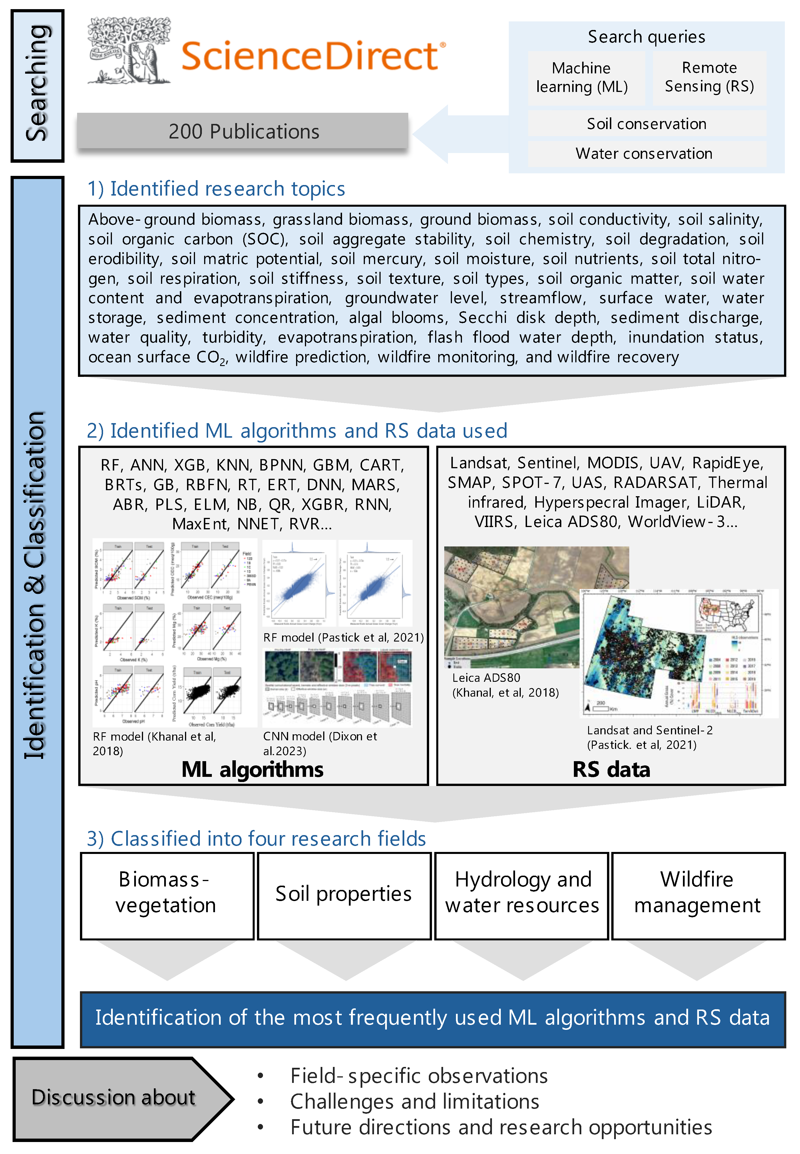
Figure 2.
A world map depicting 47 countries where research has been conducted, marked by ‘x’. Colored circles represent the number of publications in each country, with the corresponding numbers shown in the legend.
Figure 2.
A world map depicting 47 countries where research has been conducted, marked by ‘x’. Colored circles represent the number of publications in each country, with the corresponding numbers shown in the legend.
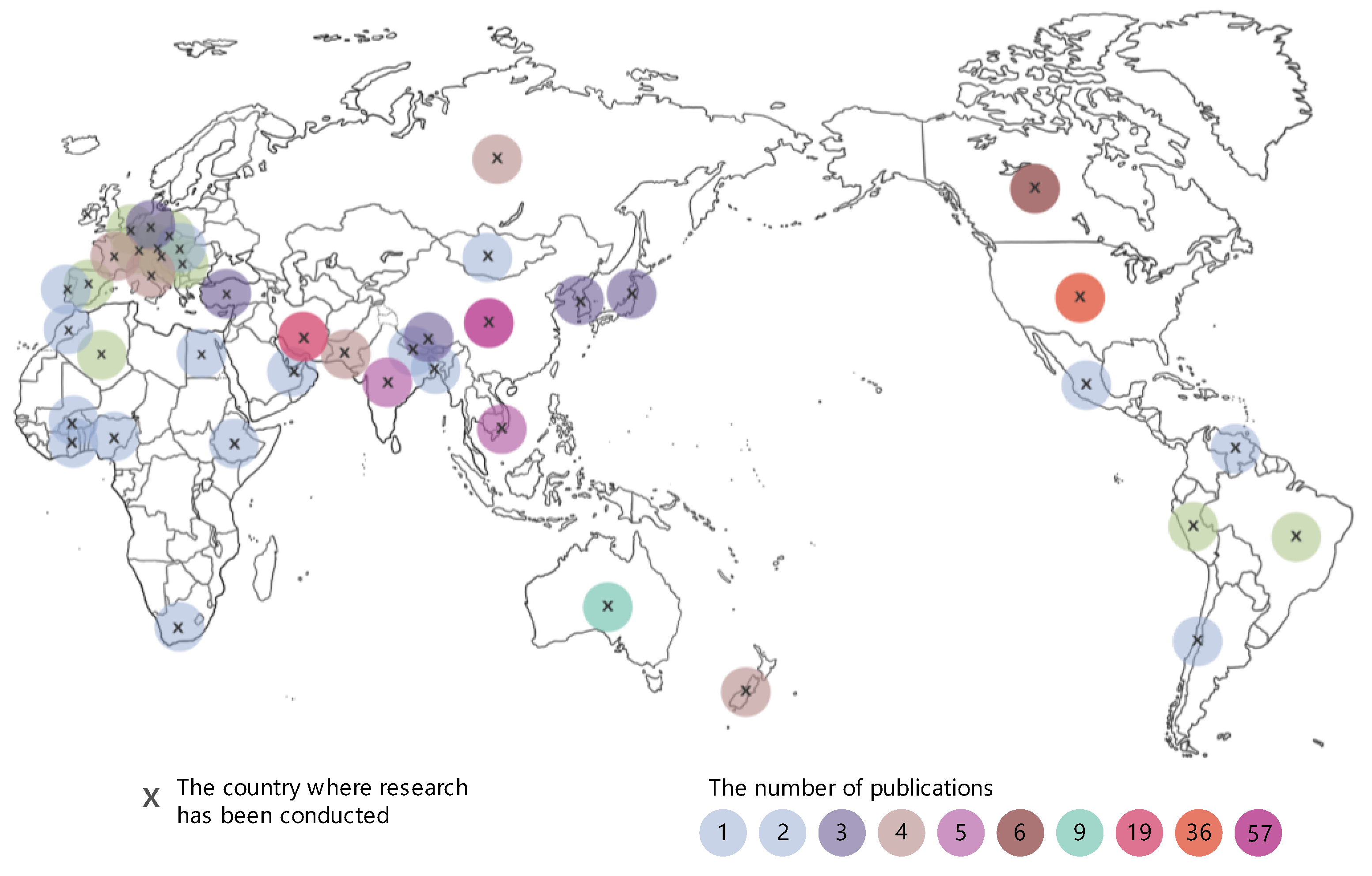
Figure 3.
Number of publications from 2006 to 2024 in four research areas: wildfire management, soil properties, hydrology and water resources, and biomass-vegetation. A notable peak in publications on wildfire management occurred around 2022.
Figure 3.
Number of publications from 2006 to 2024 in four research areas: wildfire management, soil properties, hydrology and water resources, and biomass-vegetation. A notable peak in publications on wildfire management occurred around 2022.
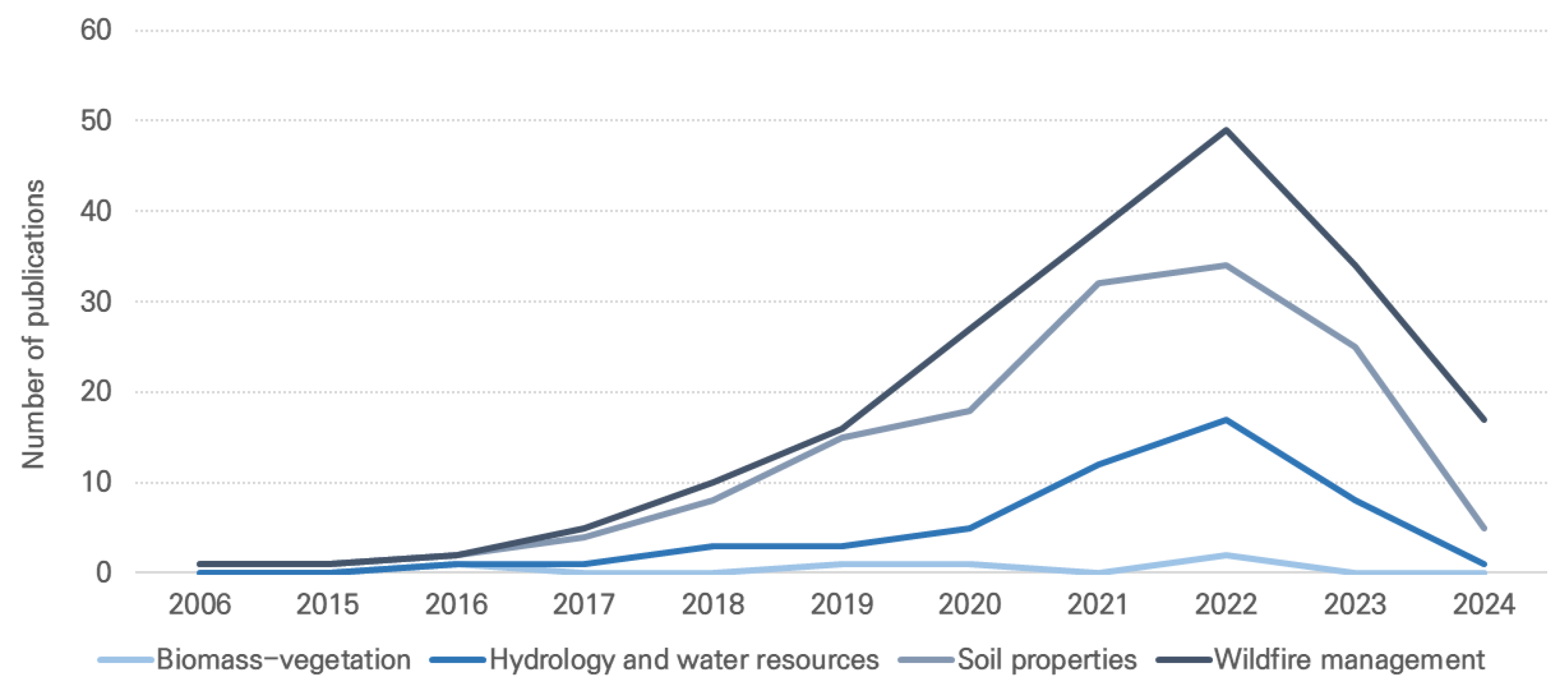
Figure 4.
Distribution of 200 research studies across four research fields. This pie chart illustrates the percentage of publications dedicated to each field: soil properties (47%), hydrology and water resources (25%), wildfire management (26%), and biomass-vegetation (2%).
Figure 4.
Distribution of 200 research studies across four research fields. This pie chart illustrates the percentage of publications dedicated to each field: soil properties (47%), hydrology and water resources (25%), wildfire management (26%), and biomass-vegetation (2%).
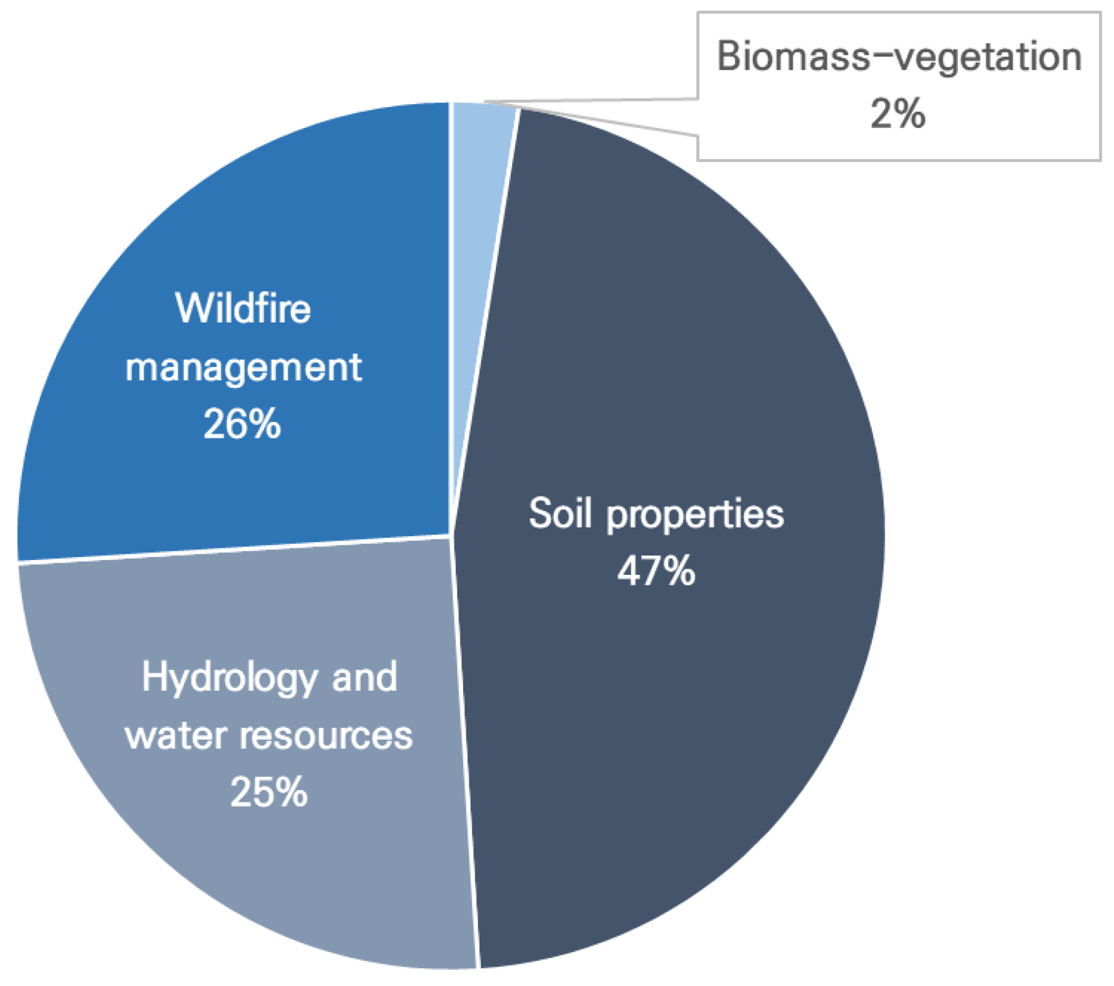
Figure 5.
Frequency of usage for RS data in soil and water conservation research. A total of 41 different RS techniques were identified. Only those used more than twice are shown in the figure. RS data used only once are not shown in the figure, including AGRS, ALOS-2, AVIRIS-NG, GF-1, Triplesat, PALSAR-2, Terra, ZH-1, ETM+, SVC, SRTM, Himawari-8, and TDC.
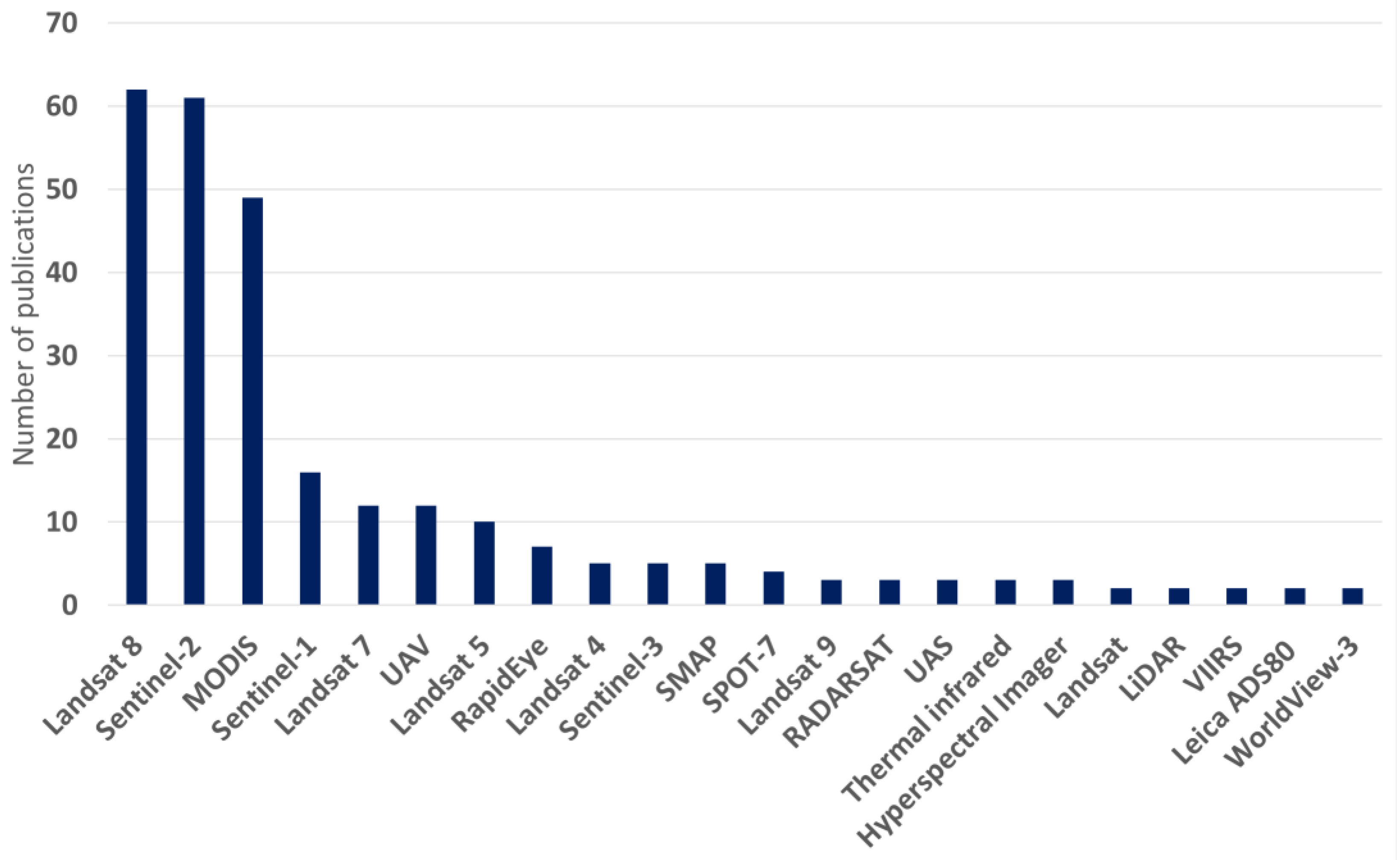
Figure 6.
Frequency of usage for ML algorithm in soil and water conservation research. RF shows the highest frequency of usage. Only algorithms used more than twice are shown in the figure. RS data used only once are not shown in the figure.
Figure 6.
Frequency of usage for ML algorithm in soil and water conservation research. RF shows the highest frequency of usage. Only algorithms used more than twice are shown in the figure. RS data used only once are not shown in the figure.
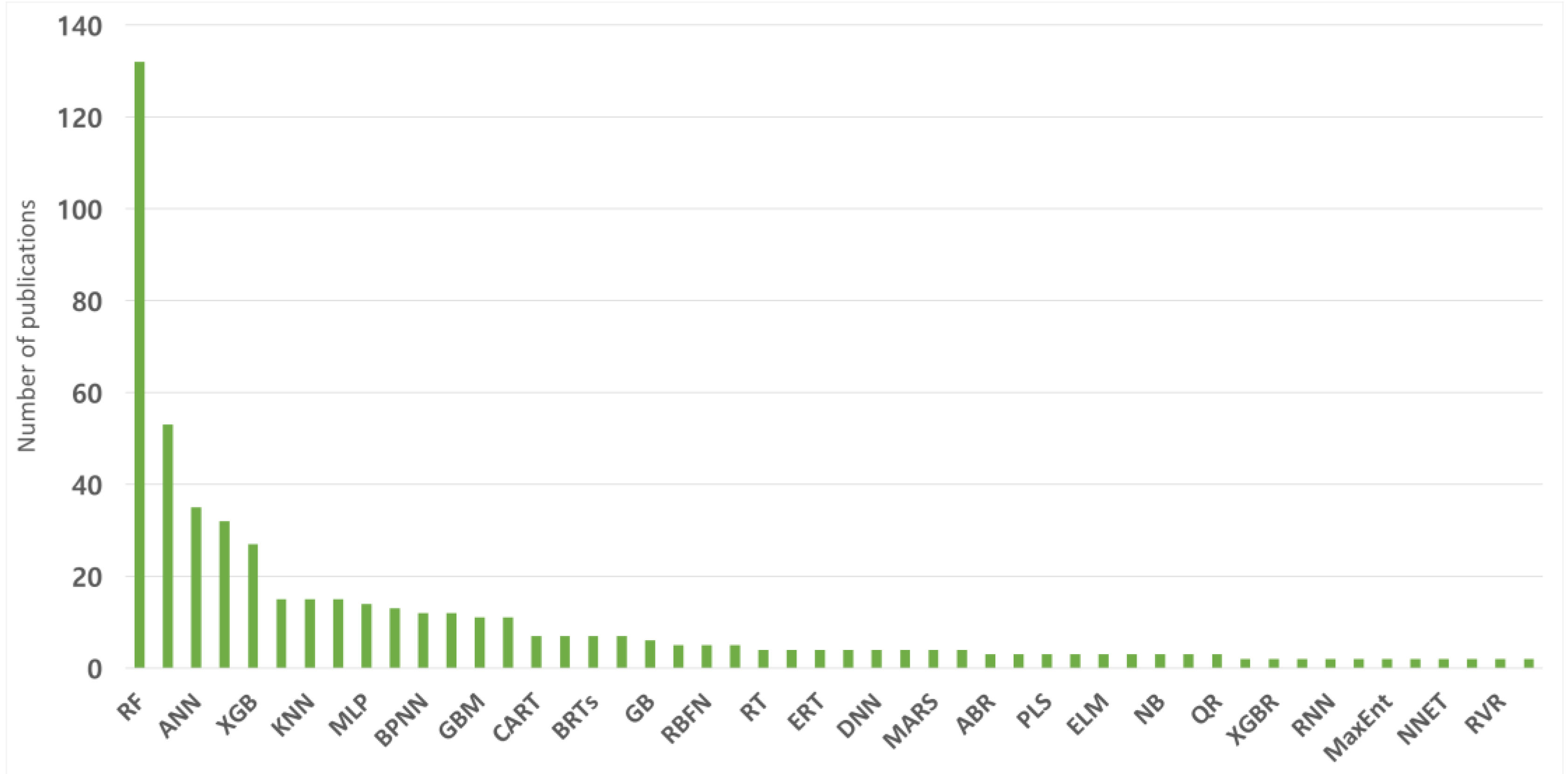
Table 1.
Classification of 200 research studies into four research fields based on their subcategorized subjects (this table lists the number of publications associated with each research field and specific subcategorized subjects within them. The four fields include biomass-vegetation, soil properties, hydrology and water resources, and wildfire management, encompassing a total of 37 subcategorized subjects)
| Research fields | Subcategorized subjects | Number of publications |
|---|---|---|
| Biomass-vegetation | Above-ground biomass[29,30,31], grassland biomass[32], ground biomass[33,34] | 5 |
| Soil properties | Soil conductivity[35,36,37], soil salinity[28,38,39,40,41,42,43,44,45,46,47,48,49,50,51,52,53,54,55,56,57], SOC [58,59,60,61,62,63,64,65,66,67,68,69,70,71,72], soil aggregate stability[73,74], soil chemistry[75,76], soil degradation[77], soil erodibility[78,79,80,81], soil matric potential[82], soil mercury[83], soil moisture[84,85,86,87,88,89,90,91,92,93,94,95,96,97,98,99,100,101,102,103,104,105,106,107,108,109,110], soil nutrients[111,112,113], soil total nitrogen[114], soil respiration[115], soil stiffness[116], soil texture[117,118,119], soil types[120], soil organic matter[121,122,123,124], soil water content and evapotranspiration[125] | 93 |
| Hydrology and water resources | Groundwater level[126], streamflow[127], surface water[128,129], water storage[130], sediment concentration[131], algal blooms[132], Secchi disk depth[133], sediment discharge[134], waters quality[135,136,137,138,139,140,141,142,143,144,145,146,147,148,149,150,151,152,153,154,155,156,157,158,159], turbidity[160,161,162,163,164,165], evapotranspiration[166,167], flash flood water depth[168], inundation status[169], ocean surface CO2[170] | 50 |
| Wildfire management | Wildfire prediction[171,172,173,174,175,176,177,178,179,180,181,182,183,184,185,186,187,188,189,190,191,192], wildfire monitoring[25,193,194,195,196,197,198,199,200,201,202,203,204,205,206,207,208,209,210,211,212,213,214,215,216,217,218], wildfire recovery[219,220] | 52 |
Table 3.
Overview of the number of publications and the top three most commonly used RS data in different research fields, including biomass-vegetation, soil properties, hydrology and water resources, and wildfire management
Table 3.
Overview of the number of publications and the top three most commonly used RS data in different research fields, including biomass-vegetation, soil properties, hydrology and water resources, and wildfire management
| Research fields | Number of publications | Top three most commonly used RS data | |
|---|---|---|---|
| Algorithms | Frequency of usages | ||
| Biomass-vegetation | 5 | (1) MODIS, UAV | 2 |
| (2) Landsat 8, Sentinel-2, ALOS-2, STRM | 1 | ||
| N/A | N/A | ||
| Soil properties | 93 | (1) Landsat 8 | 32 |
| (2) Sentinel-2 | 28 | ||
| (3) MODIS | 22 | ||
| Hydrology and water resources | 50 | (1) Landsat 8 | 18 |
| (2) Sentinel-2 | 16 | ||
| (3) Rapid Eye | 7 | ||
| Wildfire management | 52 | (1) MODIS | 20 |
| (2) Sentinel-2 | 15 | ||
| (3) Landsat 8 | 10 | ||
Table 4.
Overview of the number of publications and the top three most commonly used ML algorithms in different research fields, including biomass-vegetation, soil properties, hydrology and water resources, and wildfire management
Table 4.
Overview of the number of publications and the top three most commonly used ML algorithms in different research fields, including biomass-vegetation, soil properties, hydrology and water resources, and wildfire management
| Research fields | Number of publications | Top three most commonly used RS data | |
|---|---|---|---|
| Algorithms | Frequency of usages | ||
| Biomass-vegetation | 5 | (1) RF, ANN | 3 |
| (2) SVM, MLR | 2 | ||
| (3) ANFIS, PLS, KNN, MARS | 1 | ||
| Soil properties | 93 | (1) RF | 67 |
| (2) ANN | 23 | ||
| (3) SVM | 21 | ||
| Hydrology and water resources | 50 | (1) RF | 32 |
| (2) SVM, SVR | 14 | ||
| (3) XGB | 9 | ||
| Wildfire management | 52 | (1) RF | 30 |
| (2) SVM | 16 | ||
| (3) MLP | 7 | ||
Disclaimer/Publisher’s Note: The statements, opinions and data contained in all publications are solely those of the individual author(s) and contributor(s) and not of MDPI and/or the editor(s). MDPI and/or the editor(s) disclaim responsibility for any injury to people or property resulting from any ideas, methods, instructions or products referred to in the content. |
© 2024 by the authors. Licensee MDPI, Basel, Switzerland. This article is an open access article distributed under the terms and conditions of the Creative Commons Attribution (CC BY) license (http://creativecommons.org/licenses/by/4.0/).
Copyright: This open access article is published under a Creative Commons CC BY 4.0 license, which permit the free download, distribution, and reuse, provided that the author and preprint are cited in any reuse.


