
Submitted:
16 May 2024
Posted:
17 May 2024
You are already at the latest version
Abstract
As coastal and marine ecosystems, even the inland waters can be deeply affected by human-driven impacts. Consequently, the internal waters belonging to closed or semi-closed basins due to their hydrographic and morphological conditions can be subject to even more dramatic consequences in terms of conservation and overall ecosystem functioning maintaining. Despite the Albano Lake is listed among the Natura 2000 network sites (IT6030038), several elements of its landscape complexity have already experimented clearly visible alterations: from certain landscape features alterations to the loss of some iconic vegetal and animal species characterizing the lake environment in the past. Therefore, a virtuous commitment awaits us and we have the moral duty of acting in order to restore such degraded habitats. Each environmental restoration intervention and/or clean up session can be considered relevant in order to give back the right dignity to one of the most naturalistically relevant environments of Central Italy. For each field session a plethora of data can be acquired both onshore and underwater by diving operators. Therefore, the data management of a huge temporal and spatial variability can be remarkable. It can be made easier relying on artificial intelligence (AI) supporting geospatial databases for GIS analysis to be run for their role as decision-supporting tools. On this perspective AIs can be used to model environmental systems, greatly helping to reduce use conflicts and human-driven impacts, whilst understanding the ecological characteristics and related ecosystem functioning.
Keywords:
ecosystem restoration
; big data management
; artificial intelligence
; scientific diving
; remote sensing
; DPSIR model
1. Introduction
The Latium region is characterized by a relevant number of protected areas both in the coastal zona and in the inland ecosystems. These environments are characterized by a relevant habitat complexity. Beside the coastal zones where different environmental gradients can be retrieved, the internal areas can be mentioned for the presence of relevant natural habitats associated to freshwater and transitional ecosystems, such as that typical of inland and freshwater basins. Amongst them the volcanic ponds as the Albano Lake represents a really interesting natural laboratory in order to investigate some delicate equilibria and make some comparisons with the marine ecosystems both in shallow waters and deep-sea counterparts. This comparison at landscape and functional level might be an interesting insight. Additionally, as testified from several scientific contributions, the Italian territory is characterized by a relevant volcanic activity even in the most crowded areas of the peninsula. Really often this aspect of the geological characters of our country is underestimated and in the worst cases even neglected. Nevertheless, this aspect has to be
considered either from an environmental perspective and for the civil protection implications which might affect the social and environmental dynamics considering the presence of these kinds of emergencies.
Study Area
Not so far from Rome Municipality there is the volcanic complex of Albano Lake (also renowned as Castelgandolfo Lake in some popular and inaccurate descriptions considering its geographical location at the interface between the two municipalities). To date the freshwater basin is part of the Regional Park of “Castelli Romani” established with the regional Law 2/1984, in order to protect the integrity of the natural and cultural characteristics of the fifteen countries included within its borders. The Albano Lake is also part of the Natura 2000 network, where is mentioned as site IT6030038. Despite the apparent quiescence of the neighboring volcanic structure, the Albano Lake (Figure 1 a, b) is really interesting from a scientific perspective. Due to the historical and current manifestations attributable to secondary volcanic activity [1] it is currently under close surveillance also by researchers dealing with seismic and volcanic phenomena [2,3,4,5]. To date, due to the lack of systematic long-term ecological investigations, some areas of the lake remained underexplored and even the management perspectives for conservation purposes need to be further implemented in order to achieve a more sustainable use of this portion of the regional Protected Area and implement the extant sampling methods suggested for the same area [6].
2. Materials and Methods
During the 2021 summer campaigns the lake has been explored in several occasions through SCUBA diving sessions acted by officially recognized diving operators (Figure 2 a, b) and a subsequent survey through video and photo transects has been conducted in order to highlight the presence of relevant human-driven impacts and pollution sources attributable to some unsustainable uses of this natural area occurred in the last few years (Figure 3 a-f). According to the operational conditions and underwater visibility the first reclamation interventions occurred in the very first meters of the landward waters up to a maximum depth of 20 m along a previously marked working area. Additionally, some “search and recovery” sessions occurred also with a human safety purpose, supported more recently by the introduction of an additional surveillance service, acted by the Civil Protection volunteer divers of the nautical sector, during the bathing season which is the most crowded time lag for the lake basin.
Moreover, during the onshore fieldwork sessions some interviews and field on surveys conducted through local stakeholders’ engagement have been established. All the data mining phase have been defined in order to create a preliminary but comprehensive DPSIR assessment framework describing the main disturbance drivers highlighted in the study area, to subsequently inform a more complex and structured neural network. The latter might be based on a properly defined geodatabase aimed at integrate different sources of spatial and temporal information to be translated, on request, into scalable models even according to the operational needs.
4. Discussion
4.1 The main part of the investigated sites (GIS Map- ELABORATION IN PROGRESS) was covered by anthropogenic wastes. The most frequent objects were: glass bottles, cans and gas tanks, daily-use objects highlighting also more recent and unpleasant pollution phenomena, carcasses of boats and even home furnishings or household appliances (Figure 3 a-f). The lack of consistent fouling on some retrieved objects beside the proximity to the main riparian human settlement is the tangible proof of the certain and recent origin of the wastes input. The removal of the objects is essential in order to prevent the release on the long term of toxic compounds into the lake waters, which might alter the delicate equilibria of this closed basin.
Map 1 and 2. The overall sampled area and the detailed location of shallow water sampling transects.
4.1 The worsening of water quality and the visible water transparency falling, associated to the loss of freshwater and riparian biodiversity occurred over the years, is confirmed both from visible macroscopic alterations and oral communications by some local stakeholders and diving professionals who represent an historical memory of the area (R.S., L.S, L.N. pers. observ.). The latter highlighted also a reduction of water quality and functional alterations. As described for other European lakes [11], in the last few decades an overall trophic status declining and some functional alterations are visible also in terms of functional and biodiversity modifications. An example is the well-established presence of some allochthonous and introduced invasive species (e.g. Trachemis scripta scripta; Figure 4a; Perca fluviatilis [12] Figure 4b) and the overall waterscape alteration with visible reduction of the macroalgal component is one of the most relevant aspects highlighting one of the most significant macroscopic alterations. The lack of supporting photographic documentation for the historical information do not allow a direct comparison with the current situation (Figure 4a,b ) for a proper BACI (Before After Control Impact) design approach but the local ecological knowledge is a valid surrogate for a basic backward long-term investigation.
4.1 Despite the most recent waterscape alteration, the Albano Lake represented a noteworthy natural laboratory since ancient times [7,8] . As testified from some historical articles even some iconic characters of the scientific world (e. g. Jacques Picard) spent some times in these waters in the last few decades in order to make some advances on the scientific knowledge of this intriguing volcanic basin [9,10].
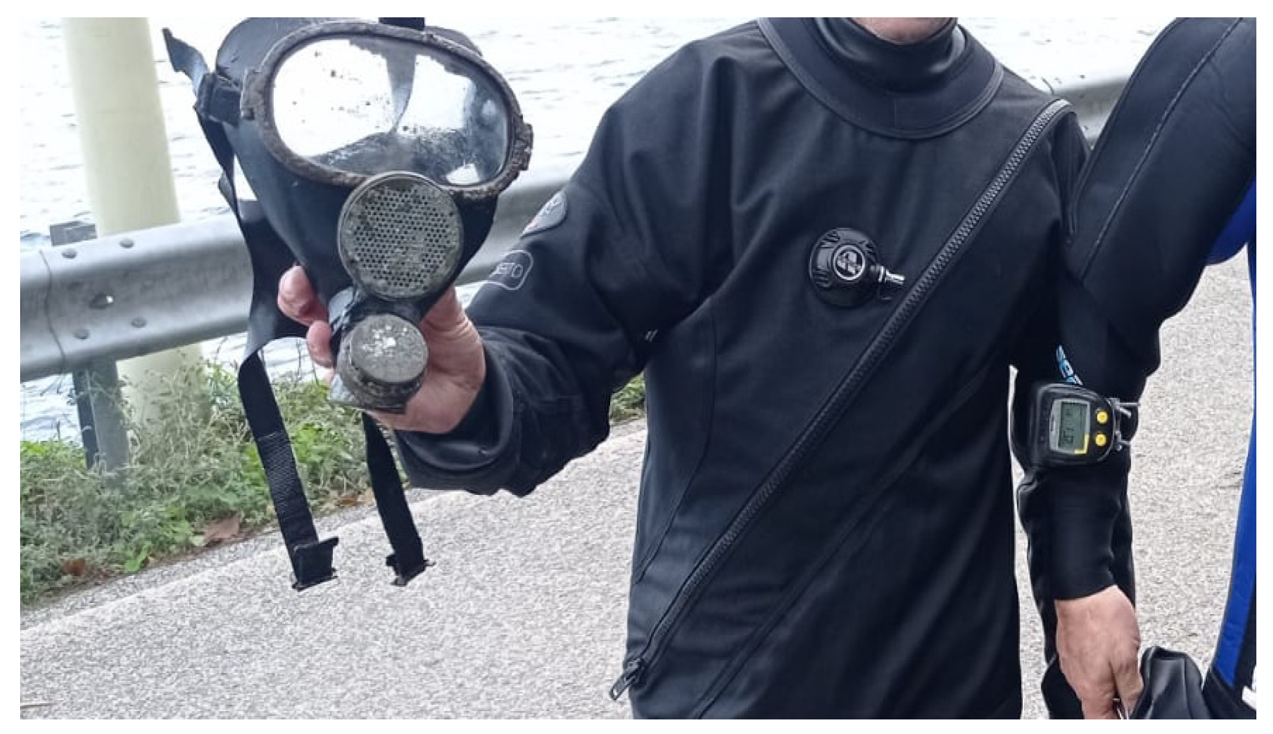
4.2 According to the main reasons of concern due to the geochemical and seismic activity [1], the lake is periodically monitored [13,14]. Nevertheless, considering the absence of a systematic integrated surveillance system based on a long-term research approach in order to monitor the area from an ecological perspective and the lack of systematic scientific diving monitoring sessions the current management plan still being perfectible. For instance, this knowledge and management gap contributed to the accumulation of wastes along the lake shores over the last few decades. The long-term persistence of abandoned wastes on the lake bottoms are confirmed also from recent findings dating back to the early sixties (Figure 5) and the several interdiction occurred periodically due to the presence of archaeological finds or remnants that have partly become points of attraction for local divers.
Moreover, the current use of the riparian area needs to be further oriented and more informative sessions and public engagement initiatives would be desirable in order to ameliorate also the awareness of local stakeholders on the potential risks of the detrimental uses acting worsening the overall quality of the lake environment. Rising awareness on the sustainable use of this natural area in a more safety condition is a priority to make effective any restoration-aimed intervention. On this purpose, the volunteer field on services conducted on the summer season 2021 highlighted the persistence of an excess of safety sense from many bathers and the seasonally-engaged operators already started some basic dissemination activities also on their own explaining the motivation of their presence on the lake shores and the ongoing initiatives (i.e. clean-up sessions, underwater monitoring activities).
4.1 Likely it might be due to the lack of knowledge of the bathymetric features and the water circulation dynamics occurring in this freshwater basin. Despite the 165 m detectable in the deepest part of the lake basin and the yearly occurrence of accidents, is not infrequent the failure to comply with the extant bathing limits, which are currently established within 200 meters from the shoreline. Additionally, some illegal activities related to unrespectful fishing activity and some acts of vandalism caused to signaling buoys or other artificial structures installed on the shores of the lake have been found. Currently, the explanatory signage in the nearby of the main landward access point is almost absent and this might disadvantage a proper information especially for the seasonal and occasional users of the lake. In order to ameliorate the general conditions of the area, especially in the most critical days of the bathing season, when the conflict related to multiple-uses of the same basin and the consequent complexity of spatial planning can be more severe (Figure 3 a, b) a surveillance service acted by volunteers and specialized departments of law enforcement agencies have been employed (Figure 4 a, b).
5. Conclusions
The reclamation and preliminary sampling work occurred in collaboration with the local division of the Civil Protection Divers and with the financial aid of Castelgandolfo Municipality and Latium Region, have been a relevant step toward a more sustainable use of the lake basin and surrounding areas in the near future. Nevertheless, these kinds of interventions need to be supported by a more stringent policy that punishes abuses, environmental crimes and misuses of extant formally recognized Protected Areas. The real success of a smart governance planning and the extant laws application in the long term is in everyone’s hands. The herein described insights and activities are part of a pilot project which will be implemented in the near future also in order to reduce the conflicts of use currently retrieved through expeditious methods and preliminary field observations.
The detailed monitoring of this kind of environments has several objectives both related to the human wellbeing, but also the environmental protection of relevant ecosystems. The volcanic lakes are the tangible proof of the significant seismic and volcanic activity present in the Italian territory and the national research institutes specialized on seismic and volcanic activity surveillance is currently engaged of the long-term geological monitoring. For these and other innumerable reason only a properly AI-supported infrastructure can help to sustain in the long-term such a huge amount of upcoming information allowing us to interpretate data and use them for effective intervention driven by operational purposes.
Author Contributions
MG conceived the paper and wrote the initial Ms with feed-back and comments of all co-authors. MG and RS performed the underwater work; MG performed all the GIS maps and preliminary DPSIR framework for geospatial analysis; RS made the photographic documentation and coordinated the schedule for the operational sessions.
Acknowledgments
On behalf of the local division of Civil Protection Divers I wish to thank all the members of the Castelgandolfo division of Civil Protection for their contribution and we are extremely grateful to the mayor Milvia Monachesi and Alberto De Angelis on behalf of the Castelgandolfo Municipality for the positive attitude toward our ongoing initiatives and the preliminary logistic aids provisioning, essential in order to support the preliminary surveys and the upcoming activities already defined in the 2021 fieldwork campaigns schedule.
Conflicts of Interest
The authors declare no conflict of interest. The funders had no role in the design of the study; in the collection, analyses, or interpretation of data; in the writing of the manuscript, or in the decision to publish the results. This contribution is the result of a personal initiative of the main author of this article.
References
- Anzidei, M. , Carapezza, M. L., Esposito, A., Giordano, G., Lelli, M., & Tarchini, L. (2008). The Albano Maar Lake high resolution bathymetry and dissolved CO2 budget (Colli Albani volcano, Italy): constrains to hazard evaluation. Journal of Volcanology and Geothermal Research, 171(3-4), 258-268.
- Anzidei, M. , Esposito, A., & De Giosa, F. (2006). The dark side of the Albano crater lake.
- Anzidei, M. , & Esposito, A. (2010). The lake Albano: bathymetry and level changes. The Colli Albani Volcano. Special Publication of IAVCEI, 3, 229–244.
- Bozzano, F. , Mazzanti, P., Anzidei, M., Esposito, C., Floris, M., Fasani, G. B., & Esposito, A. (2009). Slope dynamics of Lake Albano (Rome, Italy): insights from high resolution bathymetry. Earth Surface Processes and Landforms, 34(11), 1469-1486.
- Carapezza, M. L., Lelli, M., & Tarchini, L. (2010). Geochemistry of the Albano crater lake. The Colli Albani Volcano. Geological Society, London, Special Publications of IAVCEI, 3, 259-267.
- Crognale, J. (2017). Sperimentazione di tecniche di rilievo 3D subacqueo: applicazione ad una porzione di un deposito di frana presso il lago di Albano. unpublished master thesis in Geologia Applicata all’Ingegneria, al Territorio e ai Rischi, Sapienza Università di Roma.
- De Agostini, G. (1898). Esplorazioni idrografiche nei laghi vulcanici della provincia di Roma. Boll. Soc. geogr. it, 77.
- Pedreschi, L. (1995). I centri lacuali della penisola italiana. III: I centri dei laghi vulcanici di Castel Gandolfo e di Nemi e quelli dei bacini artificiali. Acc. Lucchese Sci. Lett. Arti, Studi e testi, Lucca, 39, 136.
- Visco R. (1984)a Picard esplora il Lago di Albano Repubblica 20 ottobre 1984 pag. 19 sez. CRONACA https://ricerca.repubblica.it/repubblica/archivio/repubblica/1984/10/20/piccard-esplora-il-lago-di-albano.html?ref=search.
- Visco R. (1984)b Con Jacques Picard sul fondo del lago Repubblica 21 ottobre 1984 pag. 17 sez. CRONACA https://ricerca.repubblica.it/repubblica/archivio/repubblica/1984/10/21/con-jacques-piccard-sul-fondo-del-lago.html?ref=search.
- Tolotti, M. , Forsström, L., Morabito, G., Thaler, B., Stoyneva, M., Cantonati, M.,... & Lotter, A. (2009). Biogeographical characterisation of phytoplankton assemblages in high altitude and high latitude European lakes. Schweizerbart’sche Verlagsbuchhandlung.
- Global Invasive Species Database (2021) Species profile: Perca fluviatilis. Downloaded from http://www.iucngisd.org/gisd/species.php?sc=548 on 19-11-2021.
- Barbieri, M. , Battistel, M., & Boschetti, T. (2013). Chemical and isotope monitoring at Lake Albano (central Italy): water-rock interaction and climate change effects. Procedia Earth and Planetary Science, 7, 53-56.
- Sighicelli, M. , Perrone, M., Lecce, F., Malavasi, M., & Scalici, M. (2021). An Integrated Approach to Chlorophyll Monitoring in Surface Freshwater: The Case Study of Lake Albano (Central Italy). Water, 13(9), 1253.
Figure 1.
(a, b) The first fieldwork session and the preliminary underwater surveys.
Figure 2.
(a, b) The first fieldwork session and the preliminary underwater surveys for wastes collection.
Figure 2.
(a, b) The first fieldwork session and the preliminary underwater surveys for wastes collection.
Figure 3.
(a, f) Some of the objects collected during the underwater monitoring sessions.
Figure 4.
a. The first in situ documentation of an adult specimen of the IAS Trachemis scripta scripta during the fieldwork session of November 2021 Figure 4b. Some juvenile individuals of Perca fluviatilis observed both during the August and November sessions.
Figure 4.
a. The first in situ documentation of an adult specimen of the IAS Trachemis scripta scripta during the fieldwork session of November 2021 Figure 4b. Some juvenile individuals of Perca fluviatilis observed both during the August and November sessions.
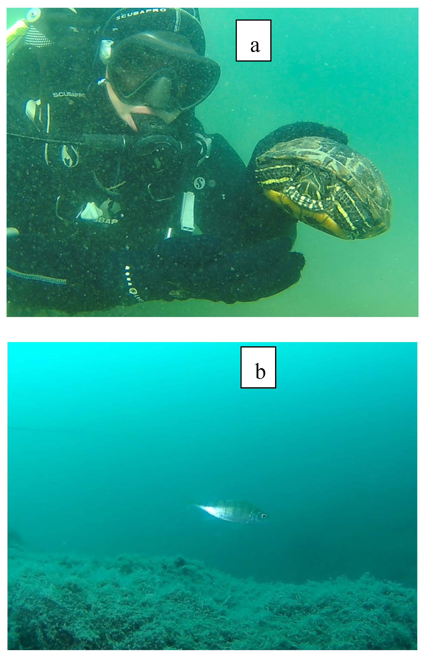
Figure 5.
The mask gas model c60 used in the early sixties from the local fire department found from the local divers in 2021.
Figure 5.
The mask gas model c60 used in the early sixties from the local fire department found from the local divers in 2021.
Disclaimer/Publisher’s Note: The statements, opinions and data contained in all publications are solely those of the individual author(s) and contributor(s) and not of MDPI and/or the editor(s). MDPI and/or the editor(s) disclaim responsibility for any injury to people or property resulting from any ideas, methods, instructions or products referred to in the content. |
© 2024 by the authors. Licensee MDPI, Basel, Switzerland. This article is an open access article distributed under the terms and conditions of the Creative Commons Attribution (CC BY) license (http://creativecommons.org/licenses/by/4.0/).
Copyright: This open access article is published under a Creative Commons CC BY 4.0 license, which permit the free download, distribution, and reuse, provided that the author and preprint are cited in any reuse.


