
Submitted:
12 March 2024
Posted:
14 March 2024
You are already at the latest version
Abstract
Historically, urban development has always been centered on coastal areas – with access to waterbodies – seas, rivers and canals being a significant advantage for movement and trade. With most of the world’s megapolises located on coasts, land reclamation offers a solution for the expansion of city centers which are otherwise restricted by the coastline. The current understanding of urban regeneration and development on reclaimed lands is defined in this study, answering the basic questions of what, why and how. This study aims to assess the urban regeneration on reclaimed coastal land based on the principles of sustainable development defined by existing studies. The literature review establishes a theoretical framework and defines performance-based benchmarks identifying the spatial indicators of urban development. Composite indicators namely open space coverage, land use mix, percentage of coast for people, accessibility to public transportation and amenities, availability of pedestrian paths and cycling tracks and adequate road networks are considered for this framework. The conclusions are drawn based on the results of the analysis of spatial layout using GIS as a tool to map and empirically measure each indicator. The framework is validated using a major land reclamation project, West Bay, in the coastal urban area of the city of Doha. The results determine that West Bay has achieved a good level of sustainability, although there are areas that could be enhanced to further improve the overall sustainability of urban development. These findings can serve as a guide for policymakers and various stakeholders for sustainable urban planning on reclaimed coastal lands.
Keywords:
coastal land reclamation
; urban planning
; urban policy
; assessment framework
; sustainable development
; sustainability indicators.
1. Introduction
The rapid urbanization of the 20th century has brought with it a variety of urban problems that need to be addressed using novel approaches. Over 44% of the world’s population live and migrate to coastal urban areas annually [1], facing a plethora of urban issues, while being additionally vulnerable to catastrophic natural events such as floods, storm surges and sea level rise. With limited land available for development on the coast, land reclamation offers a solution for dealing with the growing population and the desire to live around coastal areas [2]. A part or whole urban area reclaimed from water is common in cities worldwide today. While this practice provides more land area for development, it disrupts the natural environment and ecosystems [3]. It is, therefore, imperative to assess the degree of sustainability of urban developments on reclaimed lands to take appropriate measures to ensure that such a development has a positive impact on the environment.
Reclaimed coastal areas are under constant threat from inattentive planning policies. While sustainable development in urban areas is concerned with equitable politics, social security, economic stability, better citizen health, low carbon emissions and being close to nature without disturbing the region’s natural ecosystems and resources, planning policy in urban coastal areas is widely based on economic growth [4]. Recently, sustainable development has become a backdrop for all new developments as well as for urban areas undergoing rejuvenation or retrofitting. Efforts to make urban life healthier without endangering the health of the coastal environment and future coastal residents are defined as sustainable coastal development [5]. To provide an empirical basis for assessing the sustainable performance of urban areas, it is important to assess each urban design indicator that affects sustainability. These indicators play an important role when proposing interventions, deriving strategies and making decisions for the future. While recent research studies have focused on formulating assessment indicators for sustainable development, studies on sustainable urban development on reclaimed land, in particular, are scarce [6].
The coastal cities of the Gulf Cooperation Council (GCC) have been using land reclamation as a means of expanding their urban areas and providing additional space for development. GCC cities such as Dubai, Abu Dhabi and Doha have addressed the land scarcity issue by developing mega projects on land reclaimed from the sea. The primary intention of land reclamation is to provide more land for the city’s development. This development often takes the form of highways, airports and residential neighbourhoods with major transportation facilities, which often are not directly conducive to sustainable living as they are not used by people to live, work, play or engage with the environment [7,8]. A truly sustainable urban development would be one where people use the reclaimed land for high-density living, where one would expect high-quality housing in a high-quality public realm, where residents can easily access all the amenities by walking or cycling, and where there is sufficient space for recreational purposes, particularly those associated with the shoreline, benefiting from improved access to the water body as a result of reclamation [9,10]. Qatar, one of the fast-growing economies in the GCC commonly employs land reclamation as one of the key planning approaches to develop world-class projects on high-value land [11,12]. This study considers one of the oldest mega projects on reclaimed land, West Bay in Doha City, the capital of the State of Qatar. West Bay land reclamation has created new land for a high-rise mixed-use development that alleviates the pressure on existing land resources and has provided new opportunities for economic development [13]. In addition, West Bay land reclamation has also opened up fresh possibilities for waterfront development, including the creation of new marinas, parks and other public spaces, enhancing liveability in the city. However, it is important to assess any urban development in terms of sustainability to take into account the environmental imbalance created by land reclamation.
While land reclamation projects have been an important means of addressing land scarcity and promoting economic development in many coastal regions around the world, including the Gulf region, these projects have also been associated with a range of negative environmental impacts, including habitat loss, water pollution, and disturbance to marine ecosystems [14,15]. It is essential to assess the sustainability of land reclamation projects to identify and minimize their negative impacts and to ensure their long-term viability. A critical analysis of the urban development on reclaimed land is necessary to identify effective measures to not only mitigate any negative environmental impact but also to ensure that such land is utilised most sustainably, in a way that is beneficial to both people and the environment. This study assesses the urban development of a mega land reclamation project, West Bay, based on selected sustainability indicators and aims to guide the development of sustainable strategies that can balance economic development with environmental conservation.
2. Literature Review
2.1. Land Reclamation in Qatar – Study Area
Since the 1960s, Qatar has undergone rapid urban development due to increased migration of people and an economy driven by the oil and gas industry. Land reclamation from the sea has been an important and repetitive strategy for development in Qatar. Millions of square meters of urban land have been added with the primary goal of increasing the coastal area [16,17]. Figure 1 and Table 1show major land reclamation projects in Qatar overlaid on the original coastline.
Among the above reclamation projects in Qatar, the urban development on West Bay’s reclaimed land is selected as a case study for the following reasons: (1) This was the pioneer land reclamation project in Doha; (2) the site has reached a stage of retrofitting, meaning it has been thoroughly developed and its post-use re-evaluated, and (3) the nature of the development, i.e., mixed land use, allows us to evaluate the different dimensions of sustainability.
Urban development of West Bay began in the early 1970s when British consultant Llewellyn Davies put forward a proposal to convert the Doha Bay salt marshes into developable land through land reclamation [22,23]. The American company William Perriera and Associates then developed the design, which was immediately implemented by Emiri Diwan’s technical office. Beginning in 1974, a deep-sea bay was dredged, and the waste was used as a landfill in the adjacent salt marshes and shallow sea [24,25]. Using almost 53 million cubic meters of sand-lime, gravel and limestone, West Bay’s development was completed in 1980 but was not occupied until 1993 due to financial constraints [26,27]. In addition to creating developable land, the reclamation project also helped beautify Doha’s coastline, which now had a crescent-shaped corniche overlooking a deep-water turquoise bay, rather than what was once a shallow swampy sea. This also opened up the possibility of developing high-rise buildings overlooking the bay in place of the residential and leisure facilities originally envisaged. Development in the area accelerated around the turn of the millennium, with the area now serving as the city’s central business district and home to high-rise buildings for government and private offices, apartments, and hotels, as well as several parks, in addition to a convention centre and shopping mall [28,29,30].
2.2. Selection of Sustainability Indicators
Assessing the sustainability of urban development of land reclamation projects commonly focuses on reclamation methods, followed primarily by environmental issues such as marine health or marine pollution. This study is unique as it focuses on assessing the sustainability of urban development on reclaimed land considering the spatial strategies employed. This study considers the urban design factors impacting and influenced by reclaimed land from the existing studies and develops a unique combination of indicators to assess urban design factors. Table 2 below contains a list of existing studies and their evaluation criteria.
From the existing literature [36,37], a list of indicators that are repetitive and relevant to land reclamation is considered for this study. The identified indicators are categorized into ecological, spatial (urban) and socio-economic elements as shown in Table 3. The environmental indicators relate to the impact of reclamation on the natural environment, while the spatial indicators assess the built environment. Among the selected studies, land use mix, open space ratio and road networks are the most commonly assessed indicators. A study in Nagpur, India assesses the spatial and socio-economic aspects of 12 neighbourhoods by indexing the sustainability benchmarks [35]. A similar approach and indicators are selected for this study. The study assesses the spatial urban planning aspect to focus on the particular indicators under the category, as highlighted in Table 3.
2.3. Urban Spatial Planning Indicators
The list of urban planning spatial indicators selected for this study are:
- Open Space Coverage: The World Health Organization (WHO), 2020, defines open space as land covered with vegetation of any kind, including private and public spaces, regardless of their functions. Public open spaces are necessary in an urban environment as they act as green lungs for the city, improving the air quality as well as offering a place of respite. From various studies examining the ratio of open spaces to building fabric, 17% to 32% is the most commonly found range [38,39]. This range applies to high-, medium- and low-density urban areas, independent of townships and dedicated urban areas.
- Land Use Mix: Mixed land use is an important urban planning strategy that involves the integration of different land uses such as residential, commercial, institutional, and industrial within a single neighbourhood or district. For coastal cities, mixed land use can have significant benefits, particularly in terms of improving the resilience against sea level rise, storm surges and coastal erosions, improving the sustainability of the built environment and socio-economic fabric. Urban theorists consider land-use mix to be one of the most important tools for planning for sustainability [40]. Mixed-use neighbourhoods are sustainable since they reduce the use of cars to access other missing uses. A very diverse mix of uses provides access to a variety of facilities within shorter distances enabling people to walk or cycle to them as discussed by Moreno et al. (2021) [41].
- Coast for the public realm: The coast is an important public realm that has played a significant role in the development of many urban areas around the world. Coastal areas offer a wide range of opportunities for urban development and social interaction, including public spaces, parks, beaches, recreation areas, and commercial and residential developments. A study by Pittman et al. (2019) found that the creation of new land on the coast has facilitated the development of new urban centres, transportation infrastructure, and public amenities and concluded that the development of the coast as a public realm is essential for promoting sustainable urban development [42]. Similarly, a study in Al-Arish City, Egypt found that the redevelopment of the coast for the public realm has the potential to enhance social interaction, provide recreational opportunities, and create a sense of place for residents and visitors [43].
- Accessibility to Public Transportation: Accessibility to public transportation is a critical element of urban planning in coastal cities, providing numerous benefits such as reduced traffic congestion, improved mobility, reduced car dependency, enhanced economic development, and enhanced social inclusion [44]. It is particularly important in coastal cities where the coast is a key destination and can provide convenient and sustainable access to coastal amenities for residents and visitors alike. Public transportation can provide convenient, affordable and equitable access to beaches, waterfronts, and other coastal amenities, reducing the demand for private cars and parking [45].
- Accessibility to amenities: Accessibility to schools, healthcare facilities, and parks are crucial factors for urban development on reclaimed land. These amenities contribute to creating liveable communities and enhancing the quality of life for residents. Studies have shown that the presence of these amenities in a neighbourhood significantly impacts property values and attracts businesses, contributing to economic growth and social stability [46,47]. For example, in the development of the Marina Bay area in Singapore, accessibility to public amenities such as schools, healthcare facilities, and parks was prioritized in the planning process. This has contributed to the area’s success as a desirable location for living, working, and recreation [48].
- Pedestrian walkways: Availability and accessibility to pedestrian walkways provide safe, efficient, and sustainable mobility. Studies have shown that walkability and pedestrian-friendly design can have significant positive impacts on the economic, social, and environmental aspects of urban areas [49] and contribute to the safety and security of the area, by reducing the risks of accidents and crimes, and by increasing the visibility and informal surveillance of public spaces [50].
- Cycling tracks: Cycling infrastructure promotes sustainable transportation and helps to reduce air and noise pollution. Studies have shown that investment in cycling infrastructure leads to a net positive economic benefit by reducing the cost of infrastructure maintenance and public health expenditures [51].
- Adequate road network: A well-planned road network leads to economic benefits and improves the quality of life for residents by providing access to recreational areas and reducing travel times. For example, in the case of Hong Kong, the construction of a comprehensive road network has been essential to the development of the city. The government has invested in developing a road network that connects different parts of the city and links it to other parts of the region. This has led to increased economic activity, improved accessibility to jobs and services, and improved living conditions for residents [52].
3. The Research Design
This study is divided into 4 sections as shown in Figure 2:
3.1. Literature Review
The literature review provides a comprehensive overview of the existing knowledge and research on urban development on reclaimed lands. It helps to establish the context of the research by reviewing relevant literature on the sustainability aspects and investigating the existing assessment techniques and sustainability indicators that are employed in this study. Best practices, case studies, and success stories from previous research and practical experiences of urban development on reclaimed lands are identified. By synthesizing and evaluating the findings of previous research, the literature review can highlight best practices and lessons learned, which can inform the assessment of the sustainability of urban reclaimed lands. The literature review also assisted in identifying key sustainability indicators that are commonly used in the assessment of urban development on reclaimed lands.
3.2. Site Analysis
West Bay, the central business district in Qatar’s capital, Doha, was chosen as a case study. West Bay is a global landmark representing Qatar with its iconic skyline and high-density mixed neighbourhood planning. The whole of the West Bay neighbourhood and adjoining neighbourhoods stand on land reclaimed from the sea in the 1960s reshaping Doha city’s coastline into a crescent shape. This study recognizes the need for reclaimed urban land to be sustainable as the land cover is replaced by urban development that leaves a large carbon footprint compared to the earlier subsea area that supported natural ecosystems. This study examines and explores the West Bay post-regeneration, implemented in 2022 entitled, ‘Beautification of West Bay’ (under the Ministry of Municipality and Urban Planning). The regeneration project aimed to improve pedestrian connectivity, improve and install new bike lanes for better connectivity, and set up neighbourhood parks and green spaces along the pedestrian walkways to improve the quality of life and sustainability in the neighbourhood. In this study, all interventions implemented in the renovation project are individually evaluated.
3.3. Benchmarking and Indexing Assessment Indicators
The indexing methodology employed for this study consists of a sequence of steps as depicted in Figure 3. The selection of indicators considered the context, the scope of the study and the geography. The assessment of each indicator is indexed on a scale of one to three, with one being unacceptable and non-viable, meaning unsustainable, two representing an acceptable level, and three implying optimized standards in line with the principles of sustainable development. A Geographic Information System (GIS) is used to create a spatial mapping of various indicators and to empirically evaluate the area. The selected indicators are arranged according to their priority for implementation concerning sustainability. The final score summarizing the index and the rank of the indicator provides the score of that particular indicator for West Bay.
3.4. Assessment and Recommendations
The final weighted score summing up the performance of each indicator indicates the overall score of the West Bay area concerning sustainability. The non-viable and unsustainable indicators are highlighted, and planning policies are recommended.
4. Findings
Each selected indicator is analysed by spatial mapping on the base map of West Bay.
4.1. Open Space Coverage
Three types of open spaces are identified in West Bay, namely public open space, roadside landscape and Sikka (Arabic name for open space between houses). The mapping of these open spaces (Figure 4) shows that 18% of the total buildable area without right of way is taken up by open spaces. Based on the standards derived from the present study, the proportion of open space coverage in West Bay is the minimum, that is it falls under the “unacceptable” category as classified in this study.
4.2. Land Use Mix
This promotes compact development to reduce urban sprawl and encourage more efficient land use. A higher proportion of residential and commercial uses, with smaller percentages for industrial or manufacturing uses, are considered ideal for coastal areas. In addition, coastal cities also have to address specific challenges such as sea level rise, storm surges and coastal erosion [53]. Land use planning in coastal areas, therefore, requires a greater emphasis on green infrastructure. This study employs the commonly used land use diversity entropy index, which quantifies the homogeneity of land use in the selected area [54]. Entropy is calculated with:
Where,
Pj = the proportion of the total land area of the Jth category
J = total land uses considered in the study
The process of entropy normalization entails the utilization of the natural logarithm of the number of land uses, leading to a resulting value that falls within the range of 0 to 1. The value of 0 signifies uniformity in land use, while 1 denotes an equitable distribution of the tract of land amongst all types of land use. From Figure 1 and Table 1, the entropy index calculated based on the above equation gives a value of 0.88 which translates to 88% of land uses being equally distributed. This study categorizes 0 – 0.5 as “unacceptable”, 0.5 – 0.75 as “acceptable” and above 0.75 as “optimum”, concluding that West Bay has an optimum land use mix.
Figure 5.
Land use map of West Bay.
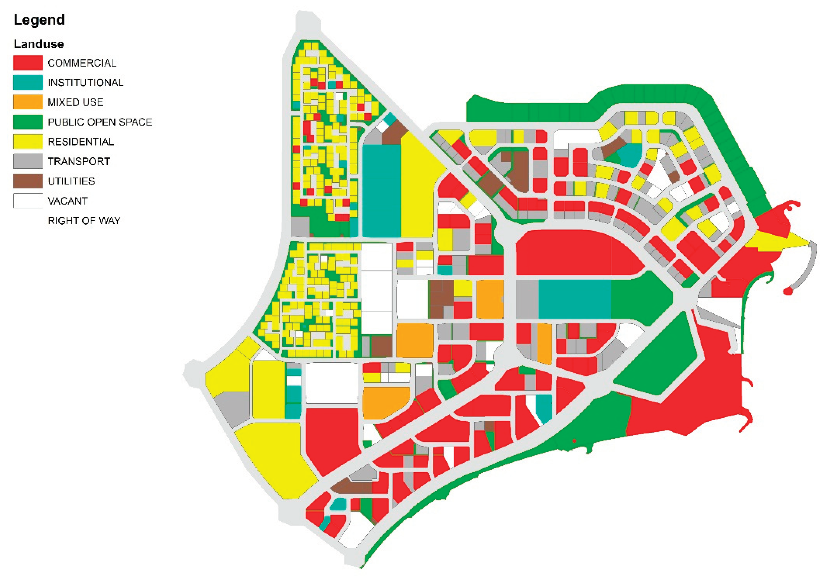

Table 4.
Land use mix area and corresponding percentage.
| Area (sqm) | % of Total | % of Developable | |
|---|---|---|---|
| Right Of Way | 1,308,997 | 28% | |
| Residential | 670,905 | 15% | 20% |
| Public open space | 601,225 | 13% | 18% |
| Commercial | 942,849 | 21% | 29% |
| Vacant | 309,106 | 7% | 9% |
| Institutional | 206,083 | 4% | 6% |
| Mixed use | 97,054 | 2% | 3% |
| Utilities | 90,531 | 2% | 3% |
| Transport | 370,917 | 8% | 11% |
| TOTAL AREA: | 4,597,667 | ||
| TOTAL DEVELOPABLE AREA: | 3,288,670 |
4.3. Coast for the Public Realm
There is no fixed ideal percentage of the coast that should be dedicated to the public realm as it can vary depending on the specific needs and goals of each project. However, providing access to the waterfront and public spaces is considered an important aspect of sustainable urban development on reclaimed lands. However, the Maasvlakte project in the Netherlands and the Marina Bay in Singapore, which are considered successful waterfront projects, dedicate more than 50% of the new coastline to public spaces, including parks, beaches, and recreational areas [55]. Taking this as the optimum range, this study classifies less than 50% of the coastline used for the public realm as unacceptable, 50 to 70% as acceptable and above 70% as an optimum range. The percentage of coastline dedicated to the public realm in West Bay is 53% which falls under the “acceptable” range (Figure 6). It is to be noted that in the case of West Bay, all the ‘Private’ waterfront is occupied by Hotel developments, whose patrons have access to the beach.
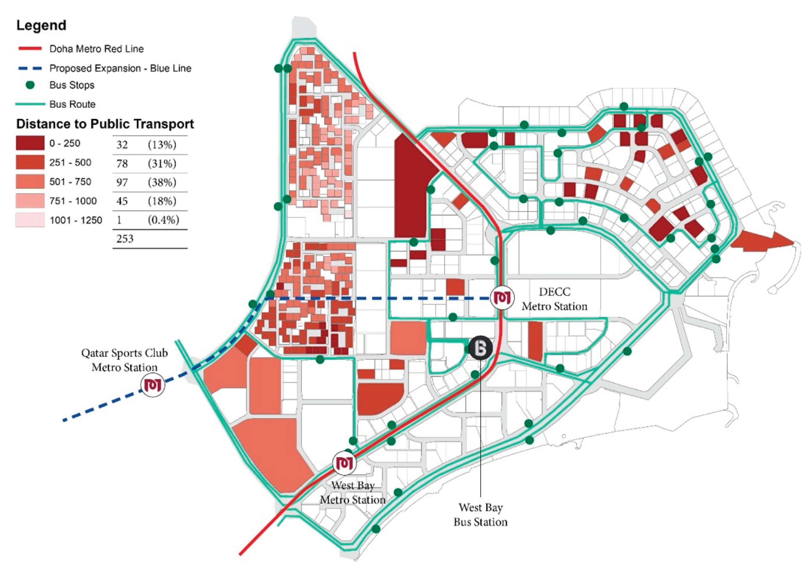
4.4. Accessibility to Public Transportation
Studies have shown that access to public transportation has a positive impact on property values, encouraging more sustainable land-use patterns and reducing automobile dependency [56,57]. In the context of reclaimed land, the development of public transportation infrastructure help to connect the area with the rest of the city and improve accessibility for residents and businesses. Efficient public transportation reduces the carbon footprint that acts as a mitigation strategy for coastal hazards such as sea level rise, storm surges and cyclones and additionally, provides efficient and affordable travel options, reducing traffic congestion and air pollution. While the standards of walkable distance to access public transportation vary due to the region and cultural dynamics, 400 to 500 meters are considered an average walkable distance for coastal cities. This research considers public transportation which is greater than 750 meters away as inaccessible. In West Bay, 44% of plots can access public transportation within 500 meters and 82% within 750 meters, thus, categorising as the “optimum” range for this study. Only 18% of plots do not have access to public transport within 750 meters, with most of them being low-density housing. All high-density residential and office buildings have access to public transportation within 750 meters.
Figure 7.
Map showing accessibility to public transportation in West Bay (Source: Authors).
4.5. Accessibility to Amenities
The accessibility of public amenities is an essential component of urban development on reclaimed lands of coastal cities, providing numerous benefits such as improved quality of life, enhanced tourism, environmental benefits, social inclusion, and community building [58]. In West Bay, 79% of the residents can access educational facilities within 750 meters (Figure 8), 2.5% of buildings have access to healthcare facilities within 750 meters (Figure 9) and 63% of buildings have access to public open spaces within 750 meters (Figure 10). Taking the average of the above data, it is concluded that around 48% of buildings in West Bay can access public amenities within 750 meters. Considering the principle of walkability, this range is under the “unacceptable” category for this study. However, this result is limited to accessibility from buildings which does not take into consideration the number of residents and building occupants.
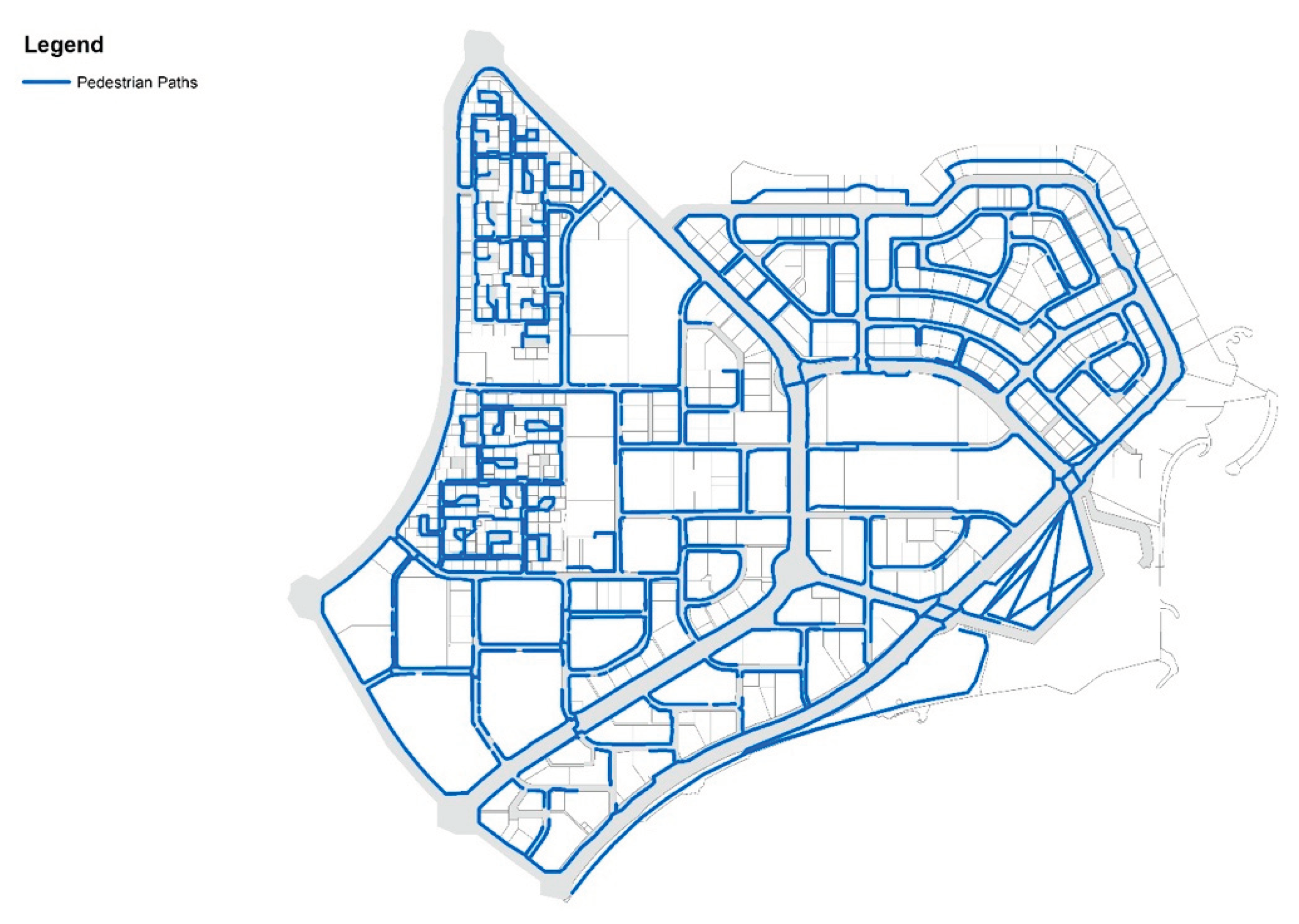
4.6. Pedestrian Pathways
Pedestrian pathways are a critical element of urban planning in coastal cities, promoting physical activity, enhancing safety, improving accessibility, supporting local businesses, and preserving the environment. To achieve walkability, it is essential to have an efficient pedestrian infrastructure [1,59]. West Bay, being the business district of Qatar, has well-maintained pedestrian connectivity. Recently, in 2021 ‘beautification of West Bay’ project was executed which focused on improving pedestrian walkways, and their connectivity, and adding street furniture and greens. There are a total of 68 kilometres of pedestrian pathways in West Bay, making it 95.8% of the adjacent road network, which falls under the “optimum” range categorized by this study.
Figure 11.
Map showing pedestrian pathways in West Bay (Source: Authors).
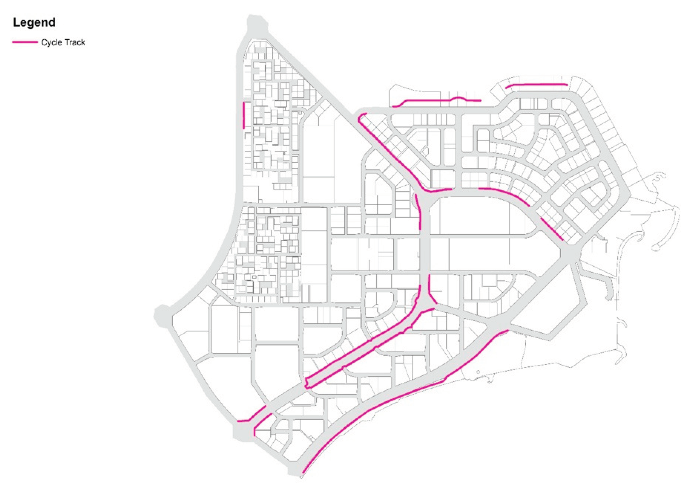
4.7. Cycle Tracks
The Ministry of Sports and Youth has created a sports movement in Qatar with its initiatives. The ministry is responsible to organize and administer various local, regional, and international sports events. Cycling in Qatar is perceived as a sport rather than a mode of transport due to car-oriented planning and climatic conditions. While new cycle tracks continue to appear, West Bay currently has 6.4 kilometres of cycle tracks. Considering Copenhagen as a benchmark, which is titled the World’s best bicycle city and where all the roads and streets are connected through bicycle tracks [60], this study contemplates that the area can be said to develop sustainably if 80% or more roads and streets are connected through cycle tracks. However, less than 50% of the area in West Bay is connected through cycling tracks making it fall under the “unacceptable” category.
Figure 12.
Map showing cycling track in West Bay (Source: Authors).
4.8. Adequate Road Network
Promoting automobile usage through road networks is considered one of the unsustainable practices. However, it is important to have a less efficient road network for economic growth and functionality of the city. West Bay has 44 kilometres of the road network within the area making it 28% of the total land area. More than 15% of the developable land allocated to the road is considered inefficient and unsustainable [61]. This study considered 15% (or less) as the optimum range; 15 – 30% as acceptable and above 30% as unacceptable.
Figure 13.
Map showing the road network in West Bay (Source: Authors).
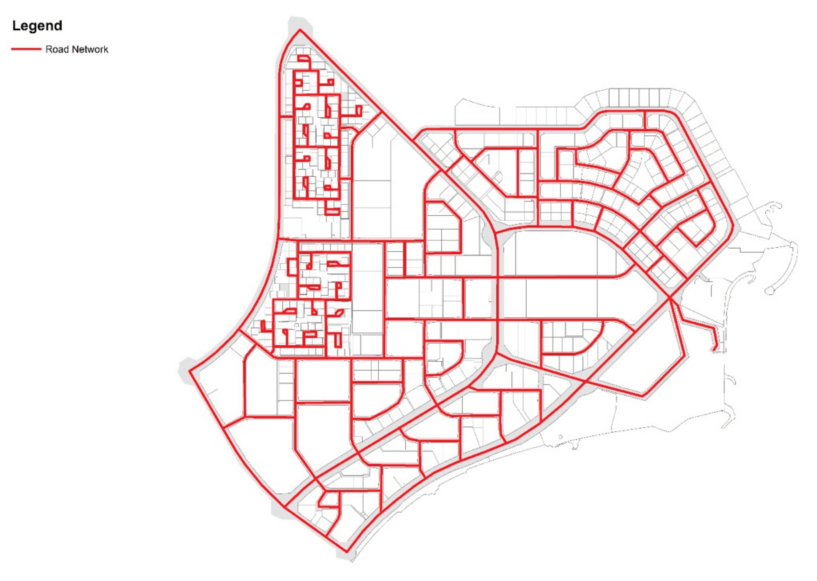
Table 5.
Sustainability assessment score for West Bay (Source: Authors).
| No. | Indicator | Benchmarks | Benchmark value for this study (A) | West Bay Score (A) | Weight for indicator (B) | (A*B) | ||
|---|---|---|---|---|---|---|---|---|
| Unacceptable (1) | Acceptable (2) | Optimum (3) | ||||||
| 1 | Open space coverage | Ratio to the total area | 17 – 22% | 23 – 18% | 28% + | 1 | 3 | 3 |
| 2 | Land use mix | Entropy index | 0 – 0.5 | 0.5 – 0.75 | 0.75 - 1 | 3 | 3 | 9 |
| 3 | % of coast for people | % of the coastline | 30 – 50% | 50 – 70% | 70% + | 2 | 3 | 6 |
| 4 | Accessibility to public transport | % of people that can access within 750 meters | 50 – 60% | 60 – 75% | 75% + | 3 | 2 | 6 |
| 5 | Accessibility to amenities | % of people that can access within 750 meters | 50 – 60% | 60 – 75% | 75% + | 1 | 2 | 2 |
| 6 | Pedestrian paths | % of pedestrian path compared to road network | < 50% | 50 to 80% | > 80% | 3 | 2 | 6 |
| 7 | Cycling tracks | % of cycle track compared to road network | < 50% | 50 to 80% | > 80% | 1 | 1 | 1 |
| 8 | Adequate road network | % of road network compared to total developable land | >30% | 15 – 30% | <15% | 2 | 1 | 2 |
| Weighted Score: | (SUM A*B)/SUM B35/17 = 2.05 | |||||||
Based on the assessment conducted on West Bay, the weighted score of all the factors is calculated as 2.05 out of 3 and therefore, it is determined that the current development is deemed sustainable, but there is room for improvement to optimize it. While West Bay has achieved a certain level of sustainability, there are areas that could be enhanced to further improve the overall performance of urban development. This involves addressing identified shortcomings, namely improving the open space coverage, accessibility to amenities and provision of cycling tracks, implementing additional measures or strategies to enhance sustainability, and ensuring that the development aligns with best practices and guidelines for sustainable urban planning and design.
4. Discussion and Conclusions
The sustainability assessment of urban development involves evaluating multiple dimensions, including environmental, social, and economic aspects and requires a thorough analysis of various indicators and criteria. This study evaluates the sustainability of urban development on reclaimed land of West Bay considering the spatial planning indicators, namely, open space coverage, land use mix, the coast of the public realm, accessibility to public transportation and amenities, pedestrian paths, cycle tracks and adequacy of the road network. The conclusions are drawn based on the results of the analysis of spatial layout using GIS as a tool to map, empirically measuring each indicator between 0 to 3 (0 being unacceptable, 1 being acceptable and 3 being optimum). The key conclusions are:
- Open space coverage falls in the unacceptable range. Efficient open spaces must be planned to make the best use of available land, provide a variety of functions (e.g., active and passive recreation, greenery, water features, etc.), and be designed in a way that maximizes their usability, sustainability, and maintenance.
- The land use is diversified and categorized in the optimum range. This indicates that the land use in the area is considered well-balanced, diverse, and appropriate, taking into consideration the goals, objectives, and principles of sustainable urban development.
- While a large part of the coast is reserved for the public realm, there are private coasts that are inaccessible to people. Making the coast optimum for the public policies related to private ownership of coastal land, establishing public easements or access points, creating public waterfronts or promenades, and ensuring that coastal areas are designed and managed in a way that promotes inclusivity, accessibility, and sustainability.
- Accessibility to public transportation and provision of pedestrian pathways fall under the optimum range. This implies that the assessed area has a well-connected and efficient public transportation system that provides convenient and reliable options for people to travel within and beyond the area.
- Accessibility to amenities and provision of cycling tracks fall under the unacceptable range. This implied that public amenities in West Bay are not easily accessible, well-distributed, and available within a reasonable distance for the residents and visitors of the area. Inadequate accessibility to amenities impacts the quality of life, well-being, and liveability of the area, and needs to be addressed through better urban planning, design, and policy interventions.
- The adequacy and efficiency of road networks fall under the acceptable range. This implies that West Bay has a road network that is considered satisfactory in terms of meeting the transportation needs of the area and maintaining reasonable traffic flow. However, interventions must be implemented to make it to an optimum level with further research.
Urban development on reclaimed lands, which are areas that have been created or expanded by filling in coastal or low-lying areas, requires special consideration and emphasis on sustainability due to several key reasons:
- Environmental Impact: Reclaimed lands often have unique ecological characteristics, including fragile ecosystems, wildlife habitats, and coastal ecosystems that may be vulnerable to disturbance or destruction during the development process. Sustainable urban development on reclaimed lands aims to minimize negative impacts on the environment, including protecting natural habitats, preserving biodiversity, and mitigating potential risks such as sea level rise and coastal erosion.
- Social Impact: Urban development on reclaimed lands can have significant social implications for local communities, including changes in land ownership, displacement of existing populations, and impacts on cultural heritage. Sustainable urban development should take into account the social aspects of land reclamation, including ensuring equitable access to housing, amenities, and public spaces, engaging local communities in decision-making processes, and addressing social and cultural impacts in a responsible manner.
- Economic Impact: Reclaimed lands are often prime real estate for urban development, and the economic benefits can be substantial. However, sustainability considerations are essential to ensure long-term economic viability. This includes factors such as optimizing land use, promoting economic diversity, integrating green and blue infrastructure, and adopting resilient design and construction practices to reduce long-term risks and costs associated with climate change impacts.
- Resilience to Climate Change: Reclaimed lands are particularly vulnerable to the impacts of climate change, such as sea level rise, storm surges, and extreme weather events. Sustainable urban development on reclaimed lands should incorporate strategies to enhance resilience to these impacts, including appropriate setback distances from coastlines, green and blue infrastructure to absorb and manage stormwater, and adaptive design measures that consider future climate projections.
- Global Sustainable Development Goals (SDGs): Sustainable urban development on reclaimed lands aligns with the United Nations’ Sustainable Development Goals (SDGs), particularly SDG 11, which focuses on making cities inclusive, safe, resilient, and sustainable. By prioritizing sustainability in urban development on reclaimed lands, it contributes to global efforts towards achieving sustainable urbanization and protecting the environment for present and future generations.
Urban planning policy recommendations to improve the sustainability of urban reclaimed land through open spaces, designing the coast for the public realm, land use mix, accessibility to public transportation and amenities, pedestrian walkways, cycle tracks and adequate road network:
- Urban planning must prioritize the creation and preservation of open space on urban reclaimed land, by requiring developers to dedicate a percentage of the land to public parks and gardens, and by encouraging the preservation and restoration of natural habitats. In addition, planners must encourage the use of green infrastructure such as bioswales and rain gardens to manage stormwater runoff and mitigate the impact of coastal hazards.
- The coast must be designed for the public realm by prioritizing pedestrian access, providing public amenities such as seating, restrooms, and drinking fountains, and creating public spaces that welcome all members of the community, regardless of income or background. This can be achieved by creating a public-private partnership involving stakeholders in the development and maintenance of the public space.
- Policies must prioritize the development of mixed-use neighbourhoods including residential, commercial, and industrial uses in close proximity to each other. In addition, planners must encourage the use of Transit-Oriented Development (TOD), which involves building compact, walkable communities around public transit stations.
- Urban planning must improve access to public transport and amenities by investing in public transport infrastructure, such as light rail, express buses and bicycle rental systems. In addition, planners must encourage the development of mixed-use developments that include essential services such as grocery stores, healthcare facilities, and schools [62,63].
- Urban planning must prioritize the development of pedestrian walkways by designing streets that prioritize pedestrian safety, creating pedestrian-only streets, and promoting the use of pedestrian-friendly technologies such as smart crosswalks and pedestrian countdown signals. Additionally, planners must encourage the development of “complete streets” that accommodate pedestrians, cyclists, and public transit users.
- Planners must promote the development of cycle tracks by creating dedicated bike lanes, providing bike-sharing systems, and promoting the use of e-bikes and other sustainable transportation options. Planners must prioritize the development of safe and connected bike networks that are integrated with public transit systems.
5. Contribution to Knowledge
The key contribution lies in the area of sustainable urban development by providing a specific framework for assessing the sustainability performance of urban development on reclaimed land, which could be adopted for future research. The study also contributes to the understanding of sustainable urban development principles and practices in the context of reclaimed coastal land and examines how sustainable development concepts such as green infrastructure, resilient design and social equity are applied in the specific context of West Bay, Doha, with new insights. In relation to the local context, this study contributes to the understanding of the unique urban form and planning of West Bay, Doha and its implications for sustainable urban development. It provides insights into the specific challenges and opportunities of Qatar’s reclaimed coastal land development, including the local social, economic, environmental and regulatory factors affecting the sustainability of such projects. Finally, the study offers recommendations for policymakers, planners and practitioners on how to address sustainability challenges and improve the sustainability performance of urban development projects on reclaimed littoral land.
This section is not mandatory but can be added to the manuscript if the discussion is unusually long or complex.
6. Implication of Practice for the Advancement of Research
The study provides insights, findings, and recommendations that can be applied by practitioners involved in urban development projects on reclaimed coastal land, particularly in the West Bay area of Doha, Qatar. It offers practical recommendations or strategies for enhancing the sustainability performance of such projects, which could inform decision-making, planning, and implementation processes. Evidence-based recommendations informing policy formulation, regulations, and guidelines for sustainable urban development in coastal areas are provided. Finally, the study identifies gaps, limitations, and areas for further research related to sustainable urban development on reclaimed coastal land. Research opportunities, data needs, and methodological approaches that could be explored in future research are highlighted. The study stimulates further research and inquiry into the sustainability performance of urban development projects on reclaimed coastal land in different contexts, beyond West Bay, Doha, Qatar.
Author Contributions
Conceptualization, Shikha Patel; methodology, Shikha Patel; software, Deepthi John; validation, Shikha Patel and Deepthi John; formal analysis, Shikha Patel; investigation, Shikha Patel; resources, Shikha Patel; data curation, Deepthi John; writing—original draft preparation, Shikha Patel; writing—review and editing, Raffaello Furlan; visualization, Deepthi John; supervision, Raffaello Furlan; project administration, Rashid Al-Matwi. All authors have read and agreed to the published version of the manuscript.
Funding
This research received no external funding.
Conflicts of Interest
The authors declare no conflicts of interest.
References
- M. R. Stuchtey et al., “Ocean Solutions That Benefit People, Nature and the Economy,” in The Blue Compendium, J. Lubchenco and P. M. Haugan, Eds., Cham: Springer International Publishing, 2023, pp. 783–906. [CrossRef]
- D. Sengupta et al., “Mapping 21st Century Global Coastal Land Reclamation,” Earth’s Future, vol. 11, no. 2, p. e2022EF002927, Feb. 2023. [CrossRef]
- G. S. Bhunia, U. Chatterjee, and P. K. Shit, “Emergence and challenges of land reclamation: issues and prospect,” in Modern Cartography Series, vol. 10, Elsevier, 2021, pp. 1–15. [CrossRef]
- E. Burton, M. Jenks, and K. Williams, Eds., Achieving Sustainable Urban Form, 0 ed. Routledge, 2013. [CrossRef]
- Our Common Future, “World Commission on Environment and Development,” Statutory Report, 1987. [Online]. Available: un.org.
- M. de Lange, “A closer look into the feasibility of future, large scale land reclamation.
- M. Al-Saidi, “Coastal Development and Climate Risk Reduction in the Persian/Arabian Gulf: The Case of Qatar,” in Climate Change and Ocean Governance, 1st ed., P. G. Harris, Ed., Cambridge University Press, 2019, pp. 60–74. [CrossRef]
- M. AlQahtany et al., “Land Reclamation in a Coastal Metropolis of Saudi Arabia: Environmental Sustainability Implications,” Water, vol. 14, no. 16, p. 2546, Aug. 2022. [CrossRef]
- M. Al-Saidi, “Disentangling the SDGs agenda in the GCC region: Priority targets and core areas for environmental action,” Front. Environ. Sci., vol. 10, p. 1025337, Nov. 2022. [CrossRef]
- Arch. S. Patel, D. M. Indraganti, and D. R. Jawarneh, “Land Surface Temperature Responses to Land Use Dynamics in Urban Areas of Doha, Qatar,” Sustainable Cities and Society, p. 105273, Feb. 2024. [CrossRef]
- R. Furlan, S. Zaina, and S. Patel, “The urban regeneration’s framework for transit villages in Qatar: the case of Al Sadd in Doha,” Environ Dev Sustain, vol. 23, no. 4, pp. 5920–5936, Apr. 2021. [CrossRef]
- A. Naimi, G. Karani, and J. Littlewood, “Stakeholder Views on Land Reclamation and Marine Environment in Doha, Qatar,” JAES, vol. 6, no. 1, 2018. [CrossRef]
- R. Furlan, “The urban regeneration of west bay, business district of Doha (state of Qatar),” JHAAS, vol. 3, no. 5, 2018. [CrossRef]
- Y. Ge and Z. Jun-yan, “Analysis of the impact on ecosystem and environment of marine reclamation--A case study in Jiaozhou Bay,” Energy Procedia, vol. 5, pp. 105–111, 2011. [CrossRef]
- M. S. Afzal, F. Tahir, and S. G. Al-Ghamdi, “Recommendations and Strategies to Mitigate Environmental Implications of Artificial Island Developments in the Gulf,” Sustainability, vol. 14, no. 9, p. 5027, Apr. 2022. [CrossRef]
- E. K. A. Morny, T. H. Margrain, A. M. Binns, and M. Votruba, “Electrophysiological ON and OFF Responses in Autosomal Dominant Optic Atrophy,” Invest Ophthalmol Vis Sci, vol. 56, no. 13, pp. 7629–7637, Dec. 2015. [CrossRef]
- M. Schrenk, Ed., REAL CORP 2012 - re-mixing the city: towards sustainability and resilience? ; proceedings of 17th International Conference on Urban Planning, Regional Development and Information Society ; Beiträge zur 17. Internationalen Konferenz zu Stadtplanung, Regionalentwicklung und Informationsgesellschaft ; [Multiversum Schwechat, Austria, 14 - 16 May 1012 ; Tagungsband]. Schwechat-Rannersdorf: Selbstverl. des Vereins CORP - Competence Center of Urban and Regional Planning, 2012.
- “Lusail city.” Doha, 2013. [Online]. Available: https://www.lusail.com/.
- Middle East, “The Pearl-Qatar,” Arabian Business, Doha, Qatar, Sep. 19, 2009. [Online]. Available: https://www.arabianbusiness.com/industries/construction/the-pearl-qatar-12768.
- M. D. Major and H. O. Tannous, “Form and Function in Two Traditional Markets of the Middle East: Souq Mutrah and Souq Waqif,” Sustainability, vol. 12, no. 17, p. 7154, Sep. 2020. [CrossRef]
- Dredging Today, “DEME: Doha Airport Built on Reclaimed Land Becomes Fully Operational,” Jun. 03, 2014. [Online]. Available: https://www.dredgingtoday.com/2014/06/03/deme-doha-airport-built-on-reclaimed-land-becomes-fully-operational/.
- R. Furlan et al., “The urban regeneration of west-bay, business district of Doha (State of Qatar): A transit-oriented development enhancing livability,” Journal of Urban Management, vol. 8, no. 1, pp. 126–144, Apr. 2019. [CrossRef]
- F. Al-Jamali, J. M. Bishop, J. Osment, D. A. Jones, and L. LeVay, “A review of the impacts of aquaculture and artificial waterways upon coastal ecosystems in the Gulf (Arabian/Persian) including a case study demonstrating how future management may resolve these impacts,” Aquatic Ecosystem Health & Management, vol. 8, no. 1, pp. 81–94, Jan. 2005. [CrossRef]
- S. Nagy, “Dressing Up Downtown: urban development and government public image in Qatar,” City & Society, vol. 12, no. 1, pp. 125–147, Jun. 2000. [CrossRef]
- V. Mirincheva, F. Wiedmann, and A. M. Salama, “The Spatial Development Potentials of Business Districts in Doha: The Case of the West Bay,” OHI, vol. 38, no. 4, pp. 16–26, Dec. 2013. [CrossRef]
- S. B. Abdelkarim, A. M. Ahmad, S. Ferwati, and K. Naji, “Urban Facility Management Improving Livability through Smart Public Spaces in Smart Sustainable Cities,” Sustainability, vol. 15, no. 23, p. 16257, Nov. 2023. [CrossRef]
- M. J. Al-Thani and M. Koç, “In Search of Sustainable Economy Indicators: A Comparative Analysis between the Sustainable Development Goals Index and the Green Growth Index,” Sustainability, vol. 16, no. 4, p. 1372, Feb. 2024. [CrossRef]
- D. Alattar, R. Furlan, M. Grosvald, and R. Al-Matwi, “West Bay Business District in Doha, State of Qatar: Envisioning a Vibrant Transit-Oriented Development,” Designs, vol. 5, no. 2, p. 33, 21. 20 May. [CrossRef]
- D. Boussaa, “Urban Regeneration and the Search for Identity in Historic Cities,” Sustainability, vol. 10, no. 2, p. 48, Dec. 2017. [CrossRef]
- S. Patel, T. Karanisa, and M. Abdel Khalek, “Backyard Urban Agriculture in Qatar: Challenges & Recommendations,” in Environmental Network Journal, 2021. [Online]. Available: https://www.researchgate. 3539.
- Yurnita, S. Trisutomo, and M. Ali, “Developing sustainability index measurement for reclamation area,” 4th International Conference on Sustainable Built Environment, 2016.
- S. A. Azwar, E. Suganda, P. Tjiptoherijanto, and H. Rahmayanti, “Model of Sustainable Urban Infrastructure at Coastal Reclamation of North Jakarta,” Procedia Environmental Sciences, vol. 17, pp. 452–461, 2013. [CrossRef]
- N. M. P. De Alencar, M. Le Tissier, S. K. Paterson, and A. Newton, “Circles of Coastal Sustainability: A Framework for Coastal Management,” Sustainability, vol. 12, no. 12, p. 4886, Jun. 2020. [CrossRef]
- T. Hu, J. Fan, H. Hou, Y. Li, Y. Li, and K. Huang, “Long-term monitoring and evaluation of land development in a reclamation area under rapid urbanization: A case-study in Qiantang New District, China,” Land Degrad Dev, vol. 32, no. 11, pp. 3259–3271, Jul. 2021. [CrossRef]
- S. Bahadure and R. Kotharkar, “Framework for measuring sustainability of neighbourhoods in Nagpur, India,” Building and Environment, vol. 127, pp. 86–97, Jan. 2018. [CrossRef]
- R. C. Lupardus, A. C. S. McIntosh, A. Janz, and D. Farr, “Succession after reclamation: Identifying and assessing ecological indicators of forest recovery on reclaimed oil and natural gas well pads,” Ecological Indicators, vol. 106, p. 105515, Nov. 2019. [CrossRef]
- A. Adesipo, D. Freese, S. Zerbe, and G. Wiegleb, “An Approach to Thresholds for Evaluating Post-Mining Site Reclamation,” Sustainability, vol. 13, no. 10, p. 5618, 21. 20 May. [CrossRef]
- W. Chi, J. Jia, T. Pan, L. Jin, and X. Bai, “Multi-Scale Analysis of Green Space for Human Settlement Sustainability in Urban Areas of the Inner Mongolia Plateau, China,” Sustainability, vol. 12, no. 17, p. 6783, Aug. 2020. [CrossRef]
- J. Yin, P. Fu, A. Cheshmehzangi, Z. Li, and J. Dong, “Investigating the Changes in Urban Green-Space Patterns with Urban Land-Use Changes: A Case Study in Hangzhou, China,” Remote Sensing, vol. 14, no. 21, p. 5410, Oct. 2022. [CrossRef]
- D. M. Koe, “Urban Vitality through a Mix of Land-uses and Functions: An Addition to Citymaker,” Minor thesis, Wageningen University and Research Centre, Wageningen, The Netherlands., 2013.
- C. Moreno, Z. Allam, D. Chabaud, C. Gall, and F. Pratlong, “Introducing the ‘15-Minute City’: Sustainability, Resilience and Place Identity in Future Post-Pandemic Cities,” Smart Cities, vol. 4, no. 1, pp. 93–111, Jan. 2021. [CrossRef]
- S. J. Pittman et al., “Marine parks for coastal cities: A concept for enhanced community well-being, prosperity and sustainable city living,” Marine Policy, vol. 103, pp. 160–171, 19. 20 May. [CrossRef]
- Rizk Hegazy, “Towards sustainable urbanization of coastal cities: The case of Al-Arish City, Egypt,” Ain Shams Engineering Journal, vol. 12, no. 2, pp. 2275–2284, Jun. 2021. [CrossRef]
- H. O. Tannous, R. Furlan, and M. D. Major, “Souq Waqif Neighborhood as a Transit-Oriented Development,” J. Urban Plann. Dev., vol. 146, no. 4, p. 05020023, Dec. 2020. [CrossRef]
- R. Furlan, A. Al-Mohannadi, M. D. Major, and T. N. K. Paquet, “A planning method for transit villages in Qatar: Souq Waqif historical district in Doha,” OHI, vol. 48, no. 2, pp. 425–446, 23. 20 May. [CrossRef]
- H. O. Tannous, M. D. Major, and R. Furlan, “Accessibility of green spaces in a metropolitan network using space syntax to objectively evaluate the spatial locations of parks and promenades in Doha, State of Qatar,” Urban Forestry & Urban Greening, vol. 58, p. 126892, Mar. 2021. [CrossRef]
- E. S. Al Fadala, R. Furlan, R. Awwaad, K. L. Marthya, and O. Tagwa, “Strategies for the urban regeneration of the Museum of Islamic Art Park in Doha, Qatar,” Journal of Urban Regeneration and Renewal, vol. 16, no. 3, pp. 318–339.
- G. Ollivier and D. Djalal, “Transit-oriented development and the case of the Marina Bay area in Singapore.” [Online]. Available: https://blogs.worldbank.org/eastasiapacific/transit-oriented-development-and-case-marina-bay-area-singapore.
- R. Furlan, B. R. Sinclair, and R. Awwaad, “Toward Sustainable Urban Development in Doha: Implementation of Transit Villages through a Multiple-Layer Analysis,” J. Urban Plann. Dev., vol. 149, no. 4, p. 05023038, Dec. 2023. [CrossRef]
- Jacobs, The death and life of great American cities, Vintage Books ed. New York: Vintage Books, 1992.
- WHO, “Cycling and walking can help reduce physical inactivity and air pollution, save lives and mitigate climate change.” [Online]. Available: https://www.who.int/europe/news/item/07-06-2022-cycling-and-walking-can-help-reduce-physical-inactivity-and-air-pollution--save-lives-and-mitigate-climate-change. 2022.
- M. Burdett, “Case study of transport infrastructure: Hong Kong.” [Online]. Available: https://geographycasestudy.com/case-study-of-transport-infrastructure-hong-kong/.
- M. Kim, S. You, J. Chon, and J. Lee, “Sustainable Land-Use Planning to Improve the Coastal Resilience of the Social-Ecological Landscape,” Sustainability, vol. 9, no. 7, p. 1086, Jun. 2017. [CrossRef]
- R. Bordoloi, A. Mote, P. P. Sarkar, and C. Mallikarjuna, “Quantification of Land Use Diversity in The Context of Mixed Land Use,” Procedia - Social and Behavioral Sciences, vol. 104, pp. 563–572, Dec. 2013. [CrossRef]
- Port of Rotterdam, “Rotterdam Mainport Development Project,” Design report, 2021. [Online]. Available: https://www.portofrotterdam.com/en/building-port/ongoing-projects/rotterdam-mainport-development-project.
- Al-Malki, R. Awwaad, R. Furlan, M. Grosvald, and R. Al-Matwi, “Transit-Oriented Development and Livability: The Case of the Najma and Al Mansoura Neighborhoods in Doha, Qatar,” UP, vol. 7, no. 4, Oct. 2022. [CrossRef]
- R. Furlan, M. Grosvald, and A. Azad, “A social-ecological perspective for emerging cities: The case of Corniche promenade, ‘urban majlis’ of Doha,” J Infrastruct Policy Dev, vol. 6, no. 2, p. 1496, Sep. 2022. [CrossRef]
- M. Al-Mohannadi, R. Awwaad, R. Furlan, M. Grosvald, R. Al-Matwi, and R. J. Isaifan, “Sustainable Status Assessment of the Transit-Oriented Development in Doha’s Education City,” Sustainability, vol. 15, no. 3, p. 1913, Jan. 2023. [CrossRef]
- T. De Haas and M. Schepers, “Wetland Reclamation and the Development of Reclamation Landscapes: A Comparative Framework,” Journal of Wetland Archaeology, vol. 22, no. 1–2, pp. 75–96, Jul. 2022. [CrossRef]
- City of Copenhagen, “The city of Copenhagen’s Bicycle Strategy,” Progress report, 2010. Accessed: Mar. 03, 2024. [Online]. Available: https://use.metropolis.org/case-studies/cycling-in-copenhagen.
- llael Cox et al., “Land Use: A Powerful Determinant of Sustainable & Healthy Communities,” EPA, Progress report 4.1.2, 2013. [Online]. Available: https://www.epa.gov/sites/default/files/2016-09/documents/fy13productnheerl4121land_use_synthesis.pdf.
- N. A. A. Valdeolmillos, R. Furlan, M. Tadi, B. R. Sinclair, and R. Awwaad, “Towards a knowledge-hub destination: analysis and recommendation for implementing TOD for Qatar national library metro station,” Environ Dev Sustain, Mar. 2023. [CrossRef]
- S. Patel and H. Ibrahim, “Environmental Sustainability Comparative Assessment of Low-Rise and High-Rise Neighbourhoods based on People’s Lifestyle Preferences: The Case of Doha, Qatar,” presented at the The 2nd International Conference on Civil Infrastructure and Construction, Feb. 2023, pp. 978–987. [CrossRef]
Figure 1.
Map showing major land reclamation projects in Doha with timelines (Source: Complied in GIS by authors).
Figure 1.
Map showing major land reclamation projects in Doha with timelines (Source: Complied in GIS by authors).
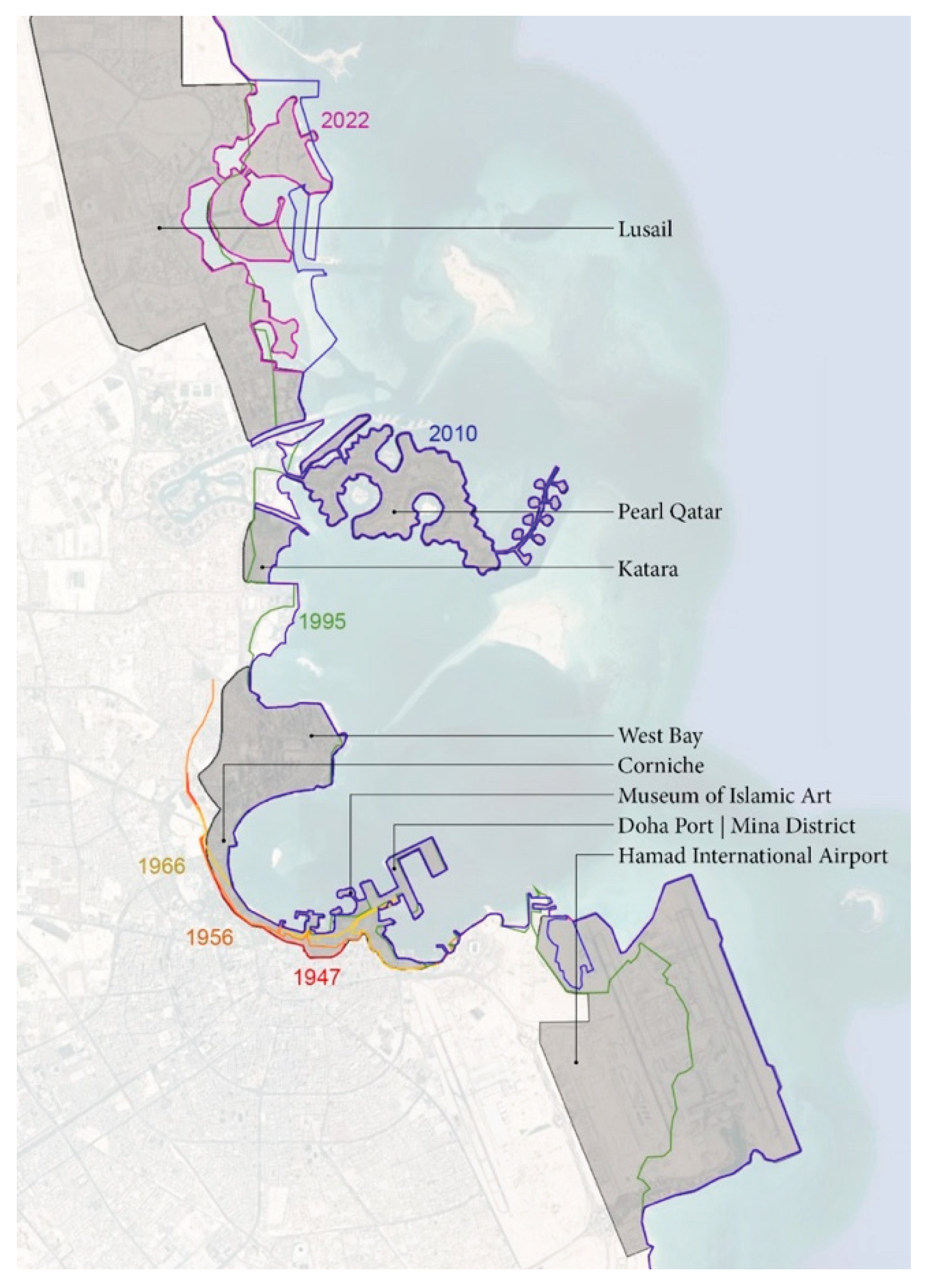
Figure 2.
The research design (Source: Authors).
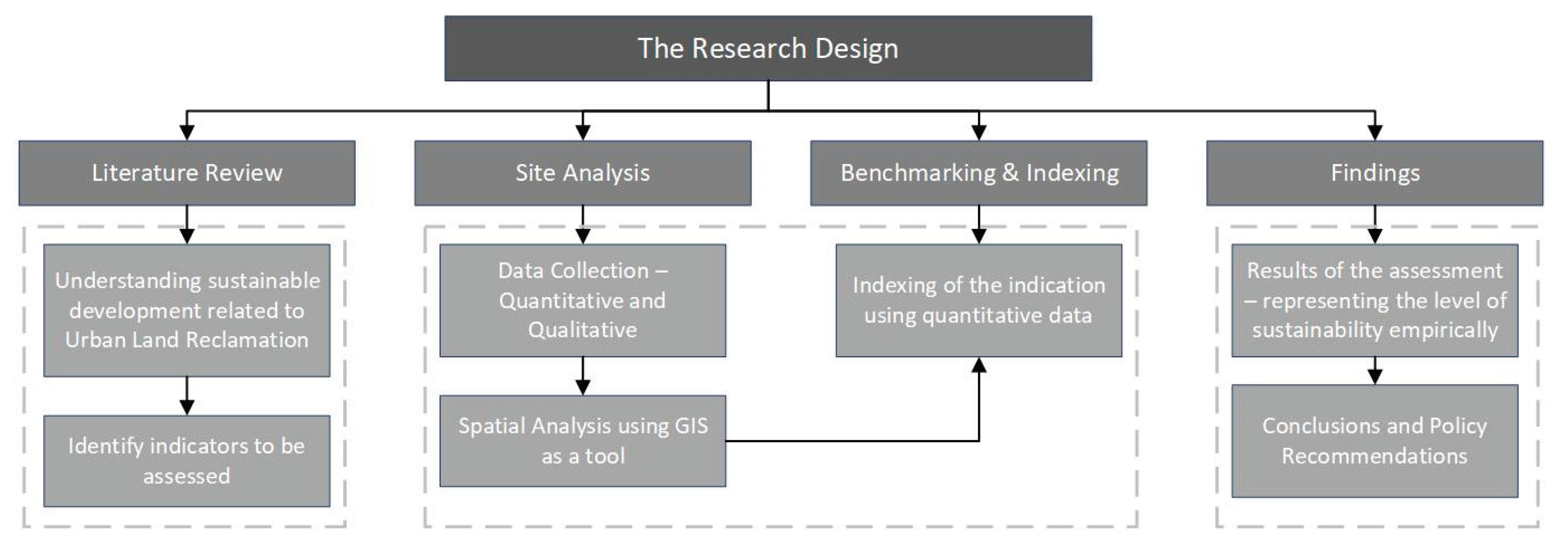
Figure 3.
Steps for Indexing method.
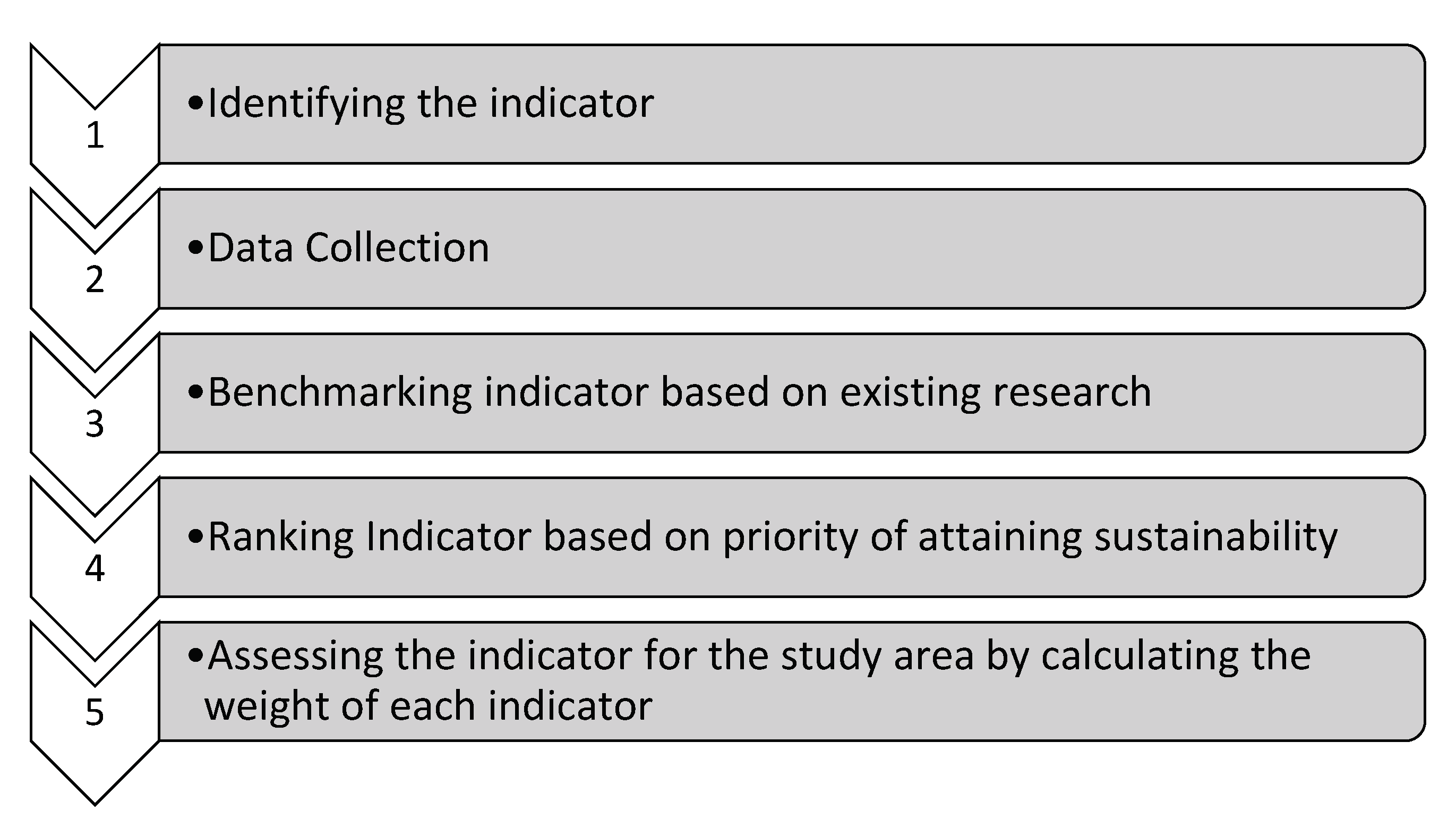
Figure 4.
Open space coverage for West Bay is 18% as against the buildable area (Source: Authors).
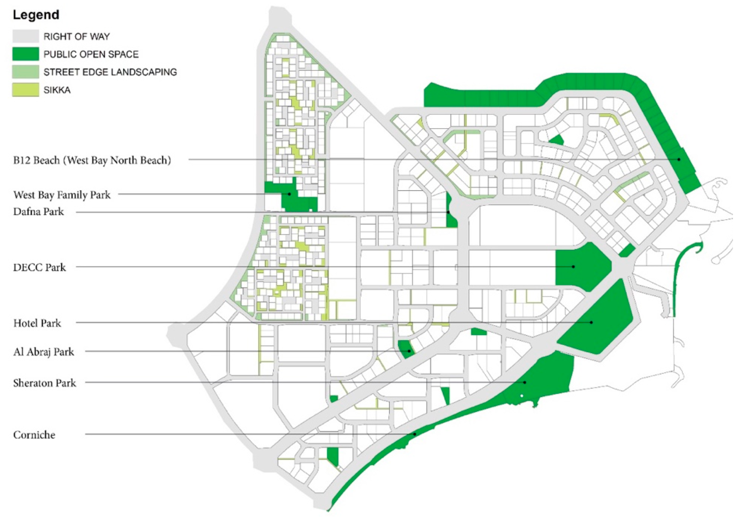
Figure 6.
Coastline of West Bay classified for private and the public realm (Source: Authors).
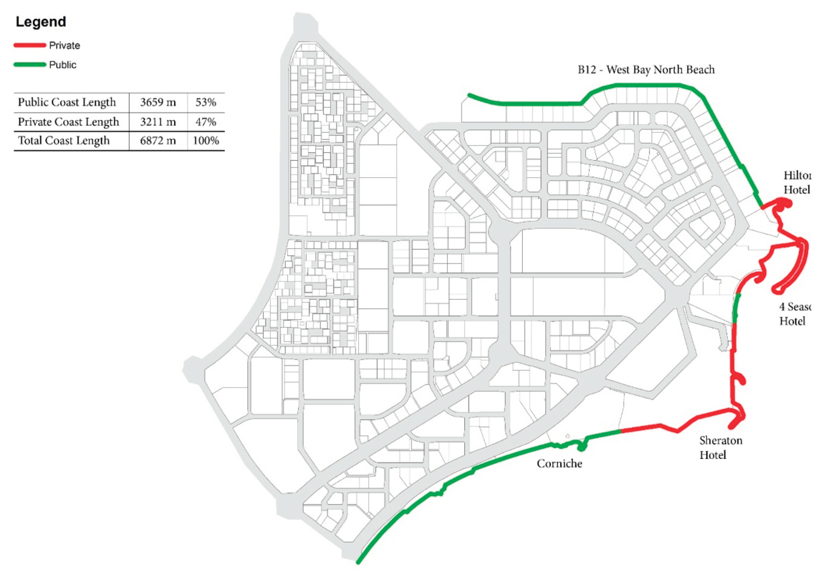
Figure 8.
Map showing accessibility to educational facilities in West Bay (Source: Authors).
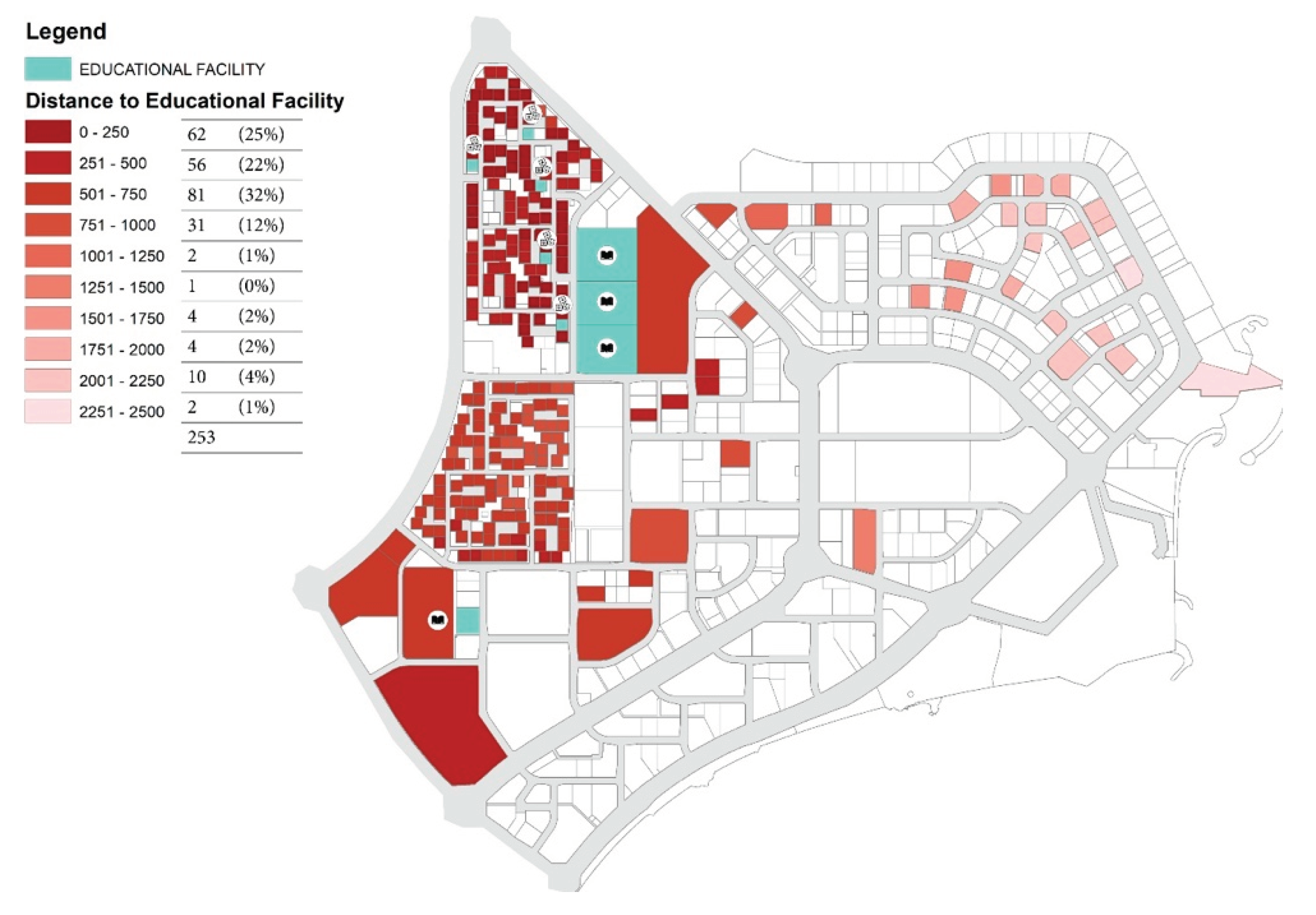
Figure 9.
Map showing accessibility to healthcare facilities in West Bay (Source: Authors).
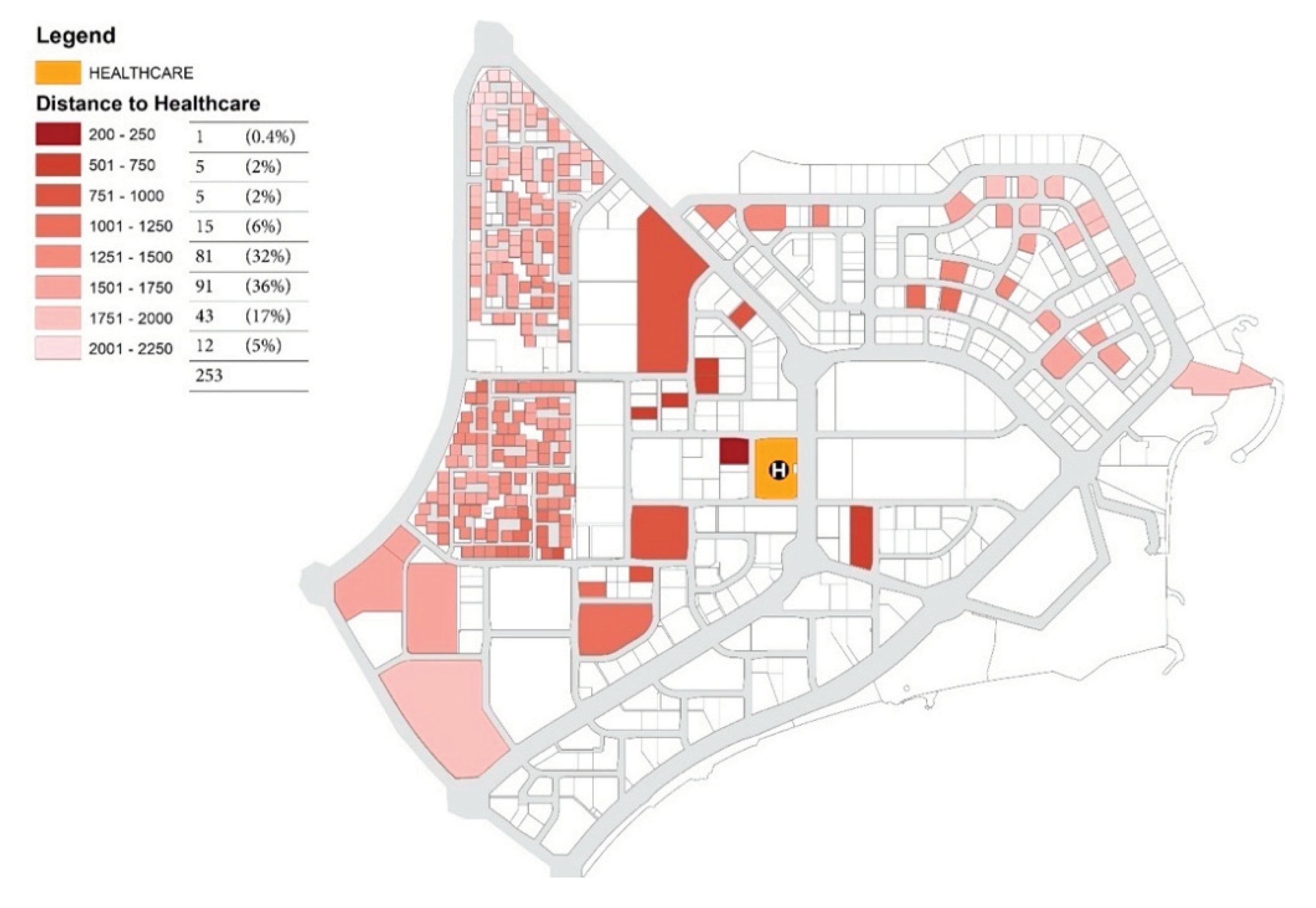
Figure 10.
Map showing accessibility to public open spaces in West Bay (Source: Authors).

Table 1.
Major land reclamation projects in Qatar.
| Area | Purpose | Year |
|---|---|---|
| Lusail City - 38 km2 with 27 Km of Coastline | Mixed-use urban development | 2013 [18] |
| The Pearl – 4 km2 with 32 Km of Coastline | Mixed-use urban development | 2004 [19] |
| Katara – 0.038 4 km2 with 1.5 Km of Coastline | Cultural Centre + Park + Retail | 2010 |
| West Bay - 20 km2 with 3.5 Km of Coastline | Central business district | 1974 [20] |
| Museum of Islamic Arts – 0.29 km2 with 1.5 Km of Coastline | Museum and public park | 2008 |
| Hamad International Airport - 22 km2 | Airport and related facility | 2014 [21] |
| Doha Port / Mina District – 1.5 km2 | Mixed Use District (Land reclaimed and used as Port prior to regeneration into Port district) | 2022 |
Table 2.
List of existing studies and their assessment criteria.
| Study Title | Citation | Key Focus | Approach |
|---|---|---|---|
| Developing Sustainability Index Measurement for Reclamation Area | [31] | Coastal resource, Building and Infrastructure | Evaluation Index System |
| Model of Sustainable Urban Infrastructure at Coastal Reclamation of North Jakarta | [32] | Land use, Transportation, Building, Open Space, Infrastructure Network, Energy | Structural Equation Modelling |
| Circles of Coastal Sustainability: A Framework for Coastal Management | [33] | Coastal Boundaries, Human well-being, Socio-ecological systems | Gap analysis of existing frameworks |
| Long-term monitoring and evaluating of land development in reclamation area under rapid urbanization: A case study in Qiantang New District, China | [34] | Land use/ land cover | Land change detection using LANDSTAT |
| Framework for measuring sustainability of neighbourhoods in Nagpur, India | [35] | Land use mix, population density, open space ratio, access to amenities, road network | Indexing the benchmarks |
Table 3.
List of indicators extracted from the existing literature.
| Environmental | Spatial – Urban Planning | Socio-Economic |
|---|---|---|
|
|
|
Disclaimer/Publisher’s Note: The statements, opinions and data contained in all publications are solely those of the individual author(s) and contributor(s) and not of MDPI and/or the editor(s). MDPI and/or the editor(s) disclaim responsibility for any injury to people or property resulting from any ideas, methods, instructions or products referred to in the content. |
© 2024 by the authors. Licensee MDPI, Basel, Switzerland. This article is an open access article distributed under the terms and conditions of the Creative Commons Attribution (CC BY) license (http://creativecommons.org/licenses/by/4.0/).
Copyright: This open access article is published under a Creative Commons CC BY 4.0 license, which permit the free download, distribution, and reuse, provided that the author and preprint are cited in any reuse.


