

Submitted:
01 December 2023
Posted:
04 December 2023
You are already at the latest version
Abstract
Hong Kong was under the direct hit of Severe Typhoon Koinu (2314) on 8 and 9 October 2023, necessitating the issuance of the Increasing Gale or Storm Signal, No. 9. Koinu was a very challenging case for TC forecasting and warning services due to its compact size and erratic movement over the northern part of the South China Sea. This paper reviews the difficulties and challenges on the forecasting aspect of the severe typhoon. The predicted tropical cyclone track and intensity from both conventional models and emerging artificial intelligence models are examined, as well as local wind and rainfall forecast. Experience in this case study showed that while deterministic global models only performed moderately and were not able to adequately support early warning, a regional model and AI models could more effectively support decision making for operational tropical cyclone warning service.
Keywords:
tropical cyclone
; track
; intensity
; wind
; rainfall
Introduction
Tropical cyclones (TCs) are a type of severe weather system that commonly affects Hong Kong. On average, approximately six TCs come within 500 km of Hong Kong in a year. These TCs can bring strong winds, heavy rain, and severe storm surge to Hong Kong and neighbouring regions depending on their track and intensity. To warn the public about potential strong wind hazards brought by TCs, a numbered TC warning system was introduced in Hong Kong in 1917. The current 1-3-8-9-10 numbering scheme for TC warning signals has been in use since 1973 (Lui et al., 2018) and is very well known by the public in Hong Kong.
Hong Kong was directly hit by two TCs within a few weeks in 2023. First, in early September 2023, Super Typhoon Saola (2309) was bringing hurricane force winds to Hong Kong, which was a rather difficult case in terms of TC forecasting due to its relatively small circulation and the interaction with Tropical Cyclone Haikui (2311) near Taiwan. The forecasting aspect of Saola has been summarized in a paper by Chan et al. (2023). Then about a month later, in early October 2023, Hong Kong was directly hit again by Severe Typhoon Koinu (2314). In He et al. (2023), an observational study had been made about Koinu. Since Koinu might bring about hurricane force winds to some places in Hong Kong, the TC warning signal No. 9 was issued for Hong Kong, meaning that gale or storm force wind is increasing or expected to increase significantly in strength (Lui et al., 2018). Under the successive strikes of TCs Saola and Koinu, this was the first time since 1999 that TC warning signal No. 9 or above was issued twice within a single TC season.
While Saola brought about big challenges on operational forecasting, Koinu was even more difficult to forecast, as far as its impact on Hong Kong was concerned due to a number of factors. As such, given todays’ technology, it is basically technically infeasible to give advance warning for the public about how strong local winds over Hong Kong could become, say, one day or even several hours ahead, which has now become the expectation from the general public. This manuscript will review the forecast difficulties of Koinu, aiming to help in the following several aspects: first, a documentation for later reference by forecasters in Hong Kong, which may also benefit other parts of the world; second, a stimulation for further study for this case in the research community, hopefully to address and resolve the forecast difficulties in the future with the advancement of technology; and third, a call for the operation of numerical weather prediction (NWP) models with higher spatial resolution and the availability of more observations over the vast ocean, namely, South China Sea in this case.
Major challenges of the forecast of Koinu
As in the case of Saola, one major challenge in forecasting the track and intensity of Koinu is its rather small and compact circulation. In fact, Koinu was even smaller than Saola. From the surface isobaric pattern when Koinu was close to Hong Kong (Figure 1(a)), its circulation was just around less than 200 km. Given such a small system, it would be rather difficult for global NWP models, with a spatial resolution as high as 9 to 10 km nowadays, to properly resolve the TC and forecast its movement and track.
The second complication is the impact of the weak northeast monsoon. In early October, it is climatologically the commencement of northeast monsoon affecting southern China. Weak monsoon flow, with slightly cooler and drier air from the continent, may occasionally reach the coast of southern China, but not yet strong enough to dominate in this region. The interaction between the northeast monsoon and a TC has long been a problem for TC warning in Hong Kong (e.g. in the case of Tropical Cyclone Nalgae in 2022, as documented in Chan et al. (2023b)). On one hand, the cooler and drier continental air might cause weakening of the TC as it gets close to the south China coast. On the other hand, the east to northeasterly monsoon winds to the northern flank of the TC and the southwesterly flow still prevailing over much of the South China Sea might enhance the horizontal shear over the region, thus favouring the intensification (or at least maintaining the intensity) of the tropical cyclone along the inter-tropical convergence zone (ITCZ). It would be a rather difficult problem for global NWP models to correctly predict which of the two competing factors would become dominating.
Thirdly, with the arrival of weak northeast monsoon at the surface, the upper flow at the middle troposphere (e.g. 700 hPa to 500 hPa) would be generally westerly. As it is still in the autumn, the westerly flow is not particularly strong (as comparing to winter time). There may be occasions of perturbations in the westerly flow, especially at the lower latitude of around 20 degrees North. Such westerly short waves may “drag” the TC, resulting in slight northward movement or at least quasi-stationary situation for the TC for a certain period of time. As such, the movement of the TC is not so steady. Given that global NWP models are still struggling to pick up short waves in the westerly, the TC track forecasting becomes rather difficult. At the same time, the vertical shearing resulting from the westerly short wave might cause gradually weakening of the TC, but it would be rather difficult to precisely predict when and where the weakening would occur. As shown in the satellite image (Figure 1(b)) and radar picture of Hong Kong (Figure 1(c)) when Koinu was close to the territory, there was an extensive cloud band and rain band to the north and northeast of Koinu, suggesting the passage of a westerly wave/trough in the middle troposphere, which partly explains the quasi-stationary or even slight northwest movement of Koinu as well as gradual weakening of the cyclone at that time. The accurate forecast of the timing of the impact of such westerly waves remains a major challenge for NWP models.
Track forecast
In the Hong Kong Observatory (HKO), tropical cyclone track forecast is mainly based on the consensus of four global NWP models, namely, European Centre of Medium-Range Weather Forecasts (ECMWF) Integrated Forecast System (IFS), Japan Meteorological Agency (JMA), National Centers for Environmental Prediction (NCEP) of the U.S., and United Kingdom Met Office (UKMO) Unified Model. In the recent couple of years, a mesoscale model with a spatial resolution of 9 km developed by Guangdong Meteorological Service of the China Meteorological Administration, named Tropical Regional Atmospheric Modelling System (TRAMS) (Zhang et al., 2022) has also been introduced for trial in HKO.
With the advancement of artificial intelligence (AI), some AI-based weather prediction models are gradually introduced to HKO. Starting from mid-2023, HKO has begun to run Pangu-Weather model (Bi et al., 2023) and Fengwu model (Chen et al., 2023), both initialized by ECMWF operational analysis.
The comparison between the various model outputs with the HKO operational analysis track is given in Figure 2 and Figure 3. At an earlier time, for example, models initialized at 12 UTC, 2 October 2023 (Figure 2), the majority of the global models, including ECMWF, JMA and UKMO, forecast that Koinu would dissipate along the eastern coast of Guangdong or its adjacent waters due to the impact of the northeast monsoon, namely, the cooling and drying effects of the monsoon is expected to play a rather significant role. However, TRAMS and the AI models suggested that Koinu may get close to Hong Kong, or at least in the vicinity of Hong Kong (mainly for the AI models). Among them, TRAMS forecast Koinu would persist at typhoon intensity (intensity forecast to be discussed in a later section in details) whereas AI models forecast the weakening of Koinu, becoming an inverted trough in the low-level northeasterly winds.
Four days later (Figure 3), the conventional global models’ deterministic forecasts converged and forecast westward movement of Koinu as it got close to Hong Kong, though the tracks were far too south of Hong Kong, so that its impact on Hong Kong would be expected to be rather minimal, whereas in reality (the operational analysis track), Koinu could get closer to Hong Kong for a while. Such a slight northward movement of Koinu was picked up by Fengwu (Figure 3(b)), though occurring at an earlier time at a rather upstream location.
To appreciate the model forecasts in depth, two strategic time instances are selected for discussion in more detail. Figure 4 shows the 96-hour forecast by ECMWF and TRAMS as initialized at 12 UTC, 4 October 2023. For comparison, the ECMWF analysis at that time is also shown. It could be seen that, for ECMWF 96-hour forecast, while the circulation of Koinu is still maintained at 700 hPa level, the TC’s surface circulation is basically gone, possibly because of the impact of the northeast monsoon. On the other hand, TRAMS kept forecasting Koinu to remain a rather strong system when it gets close to Hong Kong, and this forecast trend is rather persistent in various forecast runs at different initial times (not shown), though the circulation is too large comparing with the analysis (e.g. comparing Figure 4(f) with Figure 4(d) and Figure 1(a)).
Another point of interest in the steering flow for Koinu as depicted in the 500 hPa height. The results are shown in Figure 5. It could be seen that the various conventional models did not forecast the establishment of ridging flow to the southeast of Koinu, and then maintain continual westward movement of the cyclone. On the other hand, Fengwu forecast a slight ridging flow, and thus possibly the northwest movement of Koinu in the direction of Hong Kong (Figure 3(b)).
Ensemble prediction systems (EPS) are also considered in the HKO operation for tropical cyclones. The EPS strike probability maps at different forecast times are given in Figure 6. It could be seen that the ensemble forecasts managed to predict westward movement of Koinu across the northern part of the South China Sea. However, finer details of the movement, namely, the southward dip away from the south China coast followed by northward movement in the direction of Hong Kong, are not predicted well.
As a summary, the forecast track errors by the various models are presented in Figure 7. It could be seen that, though AI models are rather new, they are able to beat the conventional NWP models in the present case. AI models become an indispensable tool in the tropical cyclone forecast and warning services, at least for this part of the world, as it had demonstrated superior performance. This is consistently with previous study for the case of Saola as well, as in Chan et al. (2023).
Intensity forecast
The model intensity forecast at various initial times is shown in Figure 8. At first time, as given in Figure 8(a), conventional models generally managed to forecast that Koinu would reach the intensity of a severe typhoon, with the exception of UKMO. These models keep the intensification trend but over-forecast the peak intensity a bit in some later model runs (e.g. Figure 8(b)). A critical time for warning service for Koinu is the intensity of the cyclone when it gets close to Hong Kong (highlighted in red rectangles in Figure 8 (b) to (d)). A few days before Koinu’s closest approach, only TRAMS was able to forecast that Koinu would remain as a strong system, whereas the other models forecast a far too rapid weakening trend. This discrepancy still continued two days later (Figure 8(c)), so that it would be rather difficult to judge the impact of Koinu on Hong Kong several days ahead. Even a couple of days ahead (Figure 8(d)), the conventional models are still not doing a good job in the intensity forecast, with a large model spread and little consensus on the trend of intensity change.
A summary of the intensity forecast error is shown in Figure 9. It could be seen that TRAMS provided persistently much better forecast, followed by the conventional NWP models. The AI models, as expected, had too weak intensity and the errors are the largest.
Based on this single case study, the conventional NWP models were performing moderately. We may need to rely on the AI models for a more accurate track forecast and regional models (TRAMS in this case) for the intensity forecast in the formulation of tropical cyclone warning service several days ahead.
Wind forecast
For the operation of the tropical cyclone warning service in Hong Kong, accurate forecast of wind force over the territory is the most important requirement because the tropical cyclone warning signals are related to the wind strength at selected locations within the territory. A summary of the wind force forecast by the various numerical models is given in Figure 10.
A detailed discussion of the winds in Hong Kong under the influence of Koinu could be found in He et al. (2023). In summary, gale force winds were prevailing over southern part of Hong Kong, and hurricane force wind was registered at Huangmao Zhou, an island of about 50 km south of the territory (Choy et al. 2022). It could be seen that, for ECMWF and NCEP, the wind force was forecast to be rather weak and Koinu was expected to weaken much faster than actual observations. Similar to the case of Saola (Chan et al. (2023)), JMA appeared to be the best forecast of the wind structure of Koinu, as its forecast wind distribution is generally consistent with the actual observations. TRAMS also under-forecast the wind strength a bit, but winds up to 64 knots (storm force wind, in magenta in Figure 10) are expected to be rather close to southwestern part of Hong Kong. In view of these model guidance, and together with the track and intensity forecast of Koinu in this case, consideration has been made on the possibility of near-hurricane force wind or maybe even hurricane force wind near Hong Kong, which is one of the basis for the issuance of tropical cyclone warning signal No. 9 in Hong Kong.
Rainfall forecast
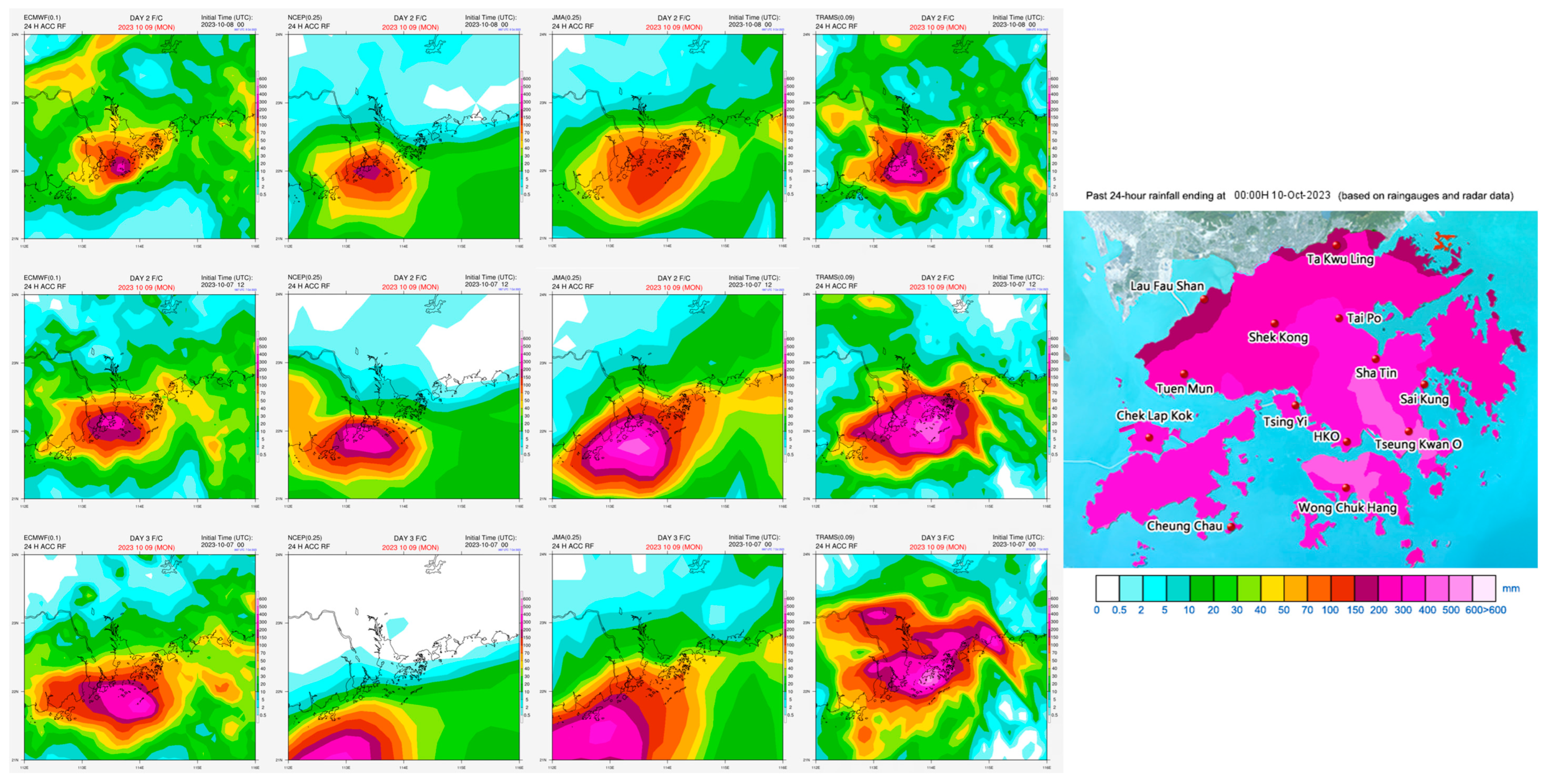
Heavy rain was generally forecast on the way with the passage of Koinu (9 October 2023) by the various NWP models. However, HKO had been asked to provide a precise estimation of the expected amount of rainfall over the territory. The rainfall forecasts by the various models and the actual rainfall pattern in Hong Kong on 9 October 2023 are summarized in Figure 11. It could be seen that, possibly due to constraints of the representation of the physical processes of rain in the models, the global NWP generally under-estimated the actual rainfall over Hong Kong, which reached 500 mm at some parts of the territory over the 24 hours of 9 October 2023. On the other hand, the regional model TRAMS appeared to perform better, in terms of the rainfall magnitude and the spatial distribution. Though TRAMS has basically similar spatial resolution (9 km) as the leading global NWP models, the rain processes are better tuned in this regional model in forecasting heavy rainfall associated with a tropical cyclone.
Conclusions
The forecasting aspects of Koinu in 2023 over the northern part of the South China Sea are summarized in this paper, namely, the track, intensity, local wind and rainfall forecast. The conventional deterministic global models are found to have moderate performance only. On the other hand, the newly emerging AI models and a regional model, appear to be better in forecasting the track and intensity of Koinu respectively. While these results are based on one case study only, more cases and examples would need to be accumulated in order to fully assess the performance of the new technologies.
From Saola and Koinu, it appears that regional model has reasonable performance in the forecast of heavy rain in association with a tropical cyclone. Wind forecast still remains rather challenging. Moreover, Koinu had a small circulation and underwent a rather irregular track over northern part of South China Sea, namely, firstly dipping to the south and later moving a bit to the north (in a horizontal “S” shape) when it came close to Hong Kong. All these posed great challenges to the warning service for this tropical cyclone. Such subtle but important changes of its movement were not well captured by available models, neither conventional nor AI, with only a weak indication by the model forecast of Fengwu which gave not-so-accurate time and location of the changes in the movement. It is hoped that the present paper could stimulate further researches to improve the track and intensity forecast of this rather difficult system, which form the basis for tropical cyclone warning service, providing better support on early alerts with longer lead time.
References
- Lui, W.H.; Lee, T.C.; Shun, C.M. Evolution of the tropical cyclone warning systems in Hong Kong since 1884. 2018, Technical Note No. 109, Hong Kong Observatory.
- Chan, P.W.; He, Y.H.; Lui, Y.S. Super Typhoon Saola (2309) affecting Hong Kong in September 2023–Forecasting Aspect. Preprints 2023, 2023091634. [CrossRef]
- He, J.; Chan, P.W.; Choy, C.W. et al. Multi-platform Observations of Severe Typhoon Koinu. ESS Open Archive. 2023. [CrossRef]
- Chan, P.W.; Choy, C.W.; Mak, B.; He, J. A Rare Tropical Cyclone Necessitating the Issuance of Gale or Storm Wind Warning Signal in Hong Kong in Late Autumn in 2022—Severe Tropical Storm Nalgae. Atmosphere 2023, 14, 170. [Google Scholar] [CrossRef]
- Zhang, Y.; Xu, D.; Chen, Z.; Meng, W. Offline Diagnostics of Skin Sea Surface Temperature from a Prognostic Scheme and Its Application in Typhoon Forecasting Using the CMA-TRAMS Model over South China. Atmosphere 2022, 13, 1324. [Google Scholar] [CrossRef]
- Bi, K.; Xie, L.; Zhang, H.; et al. Accurate medium-range global weather forecasting with 3D neural networks. Nature 2023, 619, 533–538. [Google Scholar] [CrossRef] [PubMed]
- Chen, K.; Han, T.; Gong, J.; Bai, L. et al. FengWu: Pushing the Skillful Global Medium-range Weather Forecast beyond 10 Days Lead. arXiv preprint 2023. [CrossRef]
- Choy, C.W.; Lau, D.S.; He, Y.H. Super typhoons Hato and Mangkhut, part I: analysis of maximum intensity and wind structure. Weather 2022, 77, 314–320. [Google Scholar] [CrossRef]
Figure 1.
(a) Surface weather chart at 1200 UTC on 8 October 2023, where Koinu was at its closest to Hong Kong. (b) Infrared satellite image of Himawari-9 Satellite of the Japan Meteorological Agency at 1200 UTC on 8 October 2023 showing Koinu just to the south of Hong Kong. (c) Radar image at 1200 UTC on 8 October 2023. Koinu had a compact eye, estimated to be less than about 30 km in diameter.
Figure 1.
(a) Surface weather chart at 1200 UTC on 8 October 2023, where Koinu was at its closest to Hong Kong. (b) Infrared satellite image of Himawari-9 Satellite of the Japan Meteorological Agency at 1200 UTC on 8 October 2023 showing Koinu just to the south of Hong Kong. (c) Radar image at 1200 UTC on 8 October 2023. Koinu had a compact eye, estimated to be less than about 30 km in diameter.
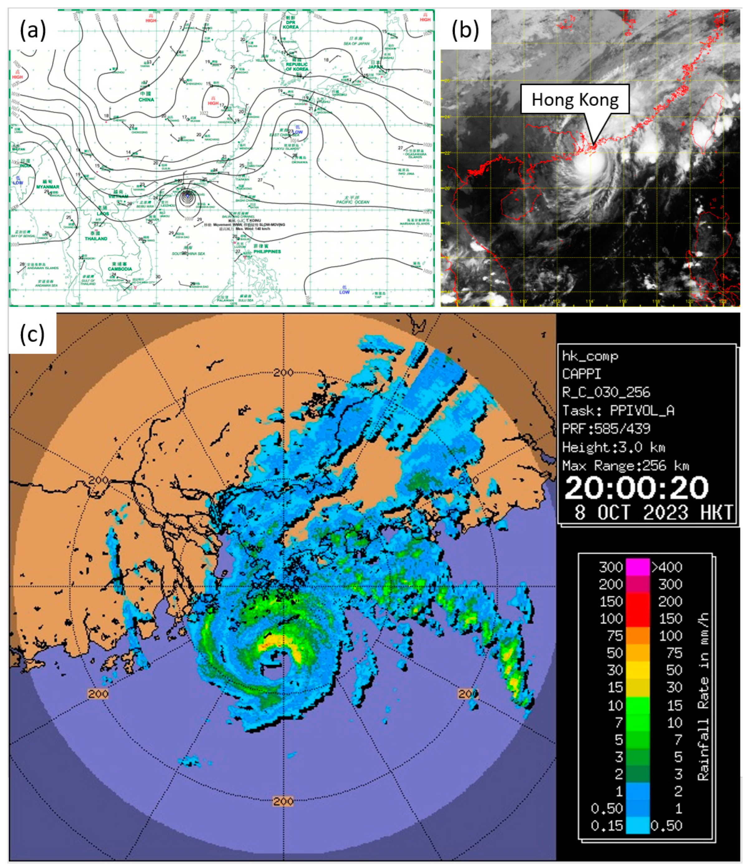
Figure 2.
Models’ forecast tracks of Koinu at 1200 UTC run on 2, October 2023. Also shown on each panel is Koinu’s analysis positions (black) based on HKO operational analysis track. (a) Forecast tracks from ECMWF, JMA, NCEP, UKMO and TRAMS. (b) Forecast tracks from AI models Pangu-Weather and Fengwu, both were initialized by the operational analysis of ECMWF.
Figure 2.
Models’ forecast tracks of Koinu at 1200 UTC run on 2, October 2023. Also shown on each panel is Koinu’s analysis positions (black) based on HKO operational analysis track. (a) Forecast tracks from ECMWF, JMA, NCEP, UKMO and TRAMS. (b) Forecast tracks from AI models Pangu-Weather and Fengwu, both were initialized by the operational analysis of ECMWF.
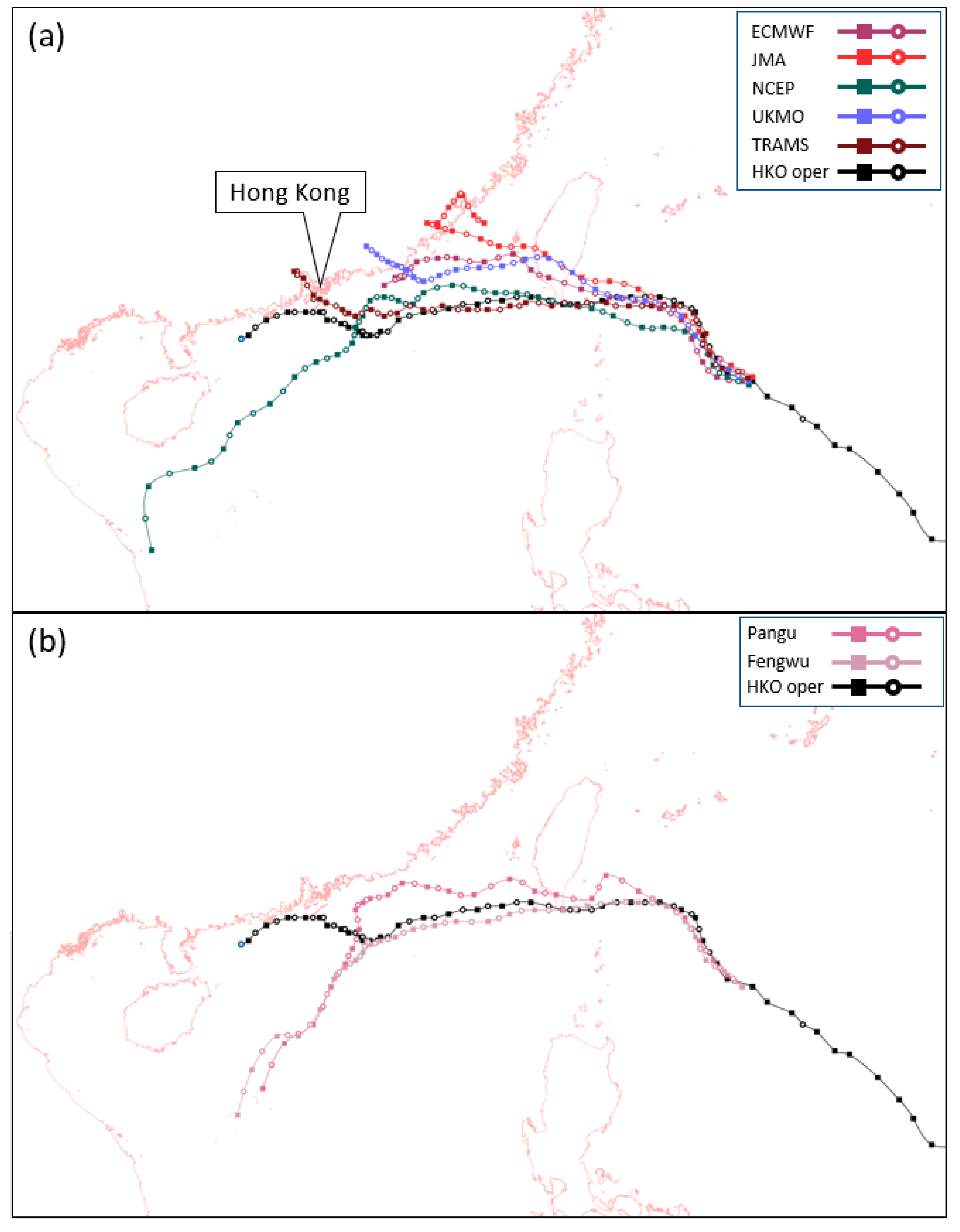
Figure 3.
Models’ forecast tracks of Koinu at 1200 UTC run on 6, October 2023. Also shown on each panel is Koinu’s analysis positions (black) based on HKO operational analysis track. (a) Forecast tracks from ECMWF, JMA, NCEP, UKMO and TRAMS. (b) Forecast tracks from AI models Pangu-Weather and Fengwu, both were initialized by the operational analysis of ECMWF.
Figure 3.
Models’ forecast tracks of Koinu at 1200 UTC run on 6, October 2023. Also shown on each panel is Koinu’s analysis positions (black) based on HKO operational analysis track. (a) Forecast tracks from ECMWF, JMA, NCEP, UKMO and TRAMS. (b) Forecast tracks from AI models Pangu-Weather and Fengwu, both were initialized by the operational analysis of ECMWF.
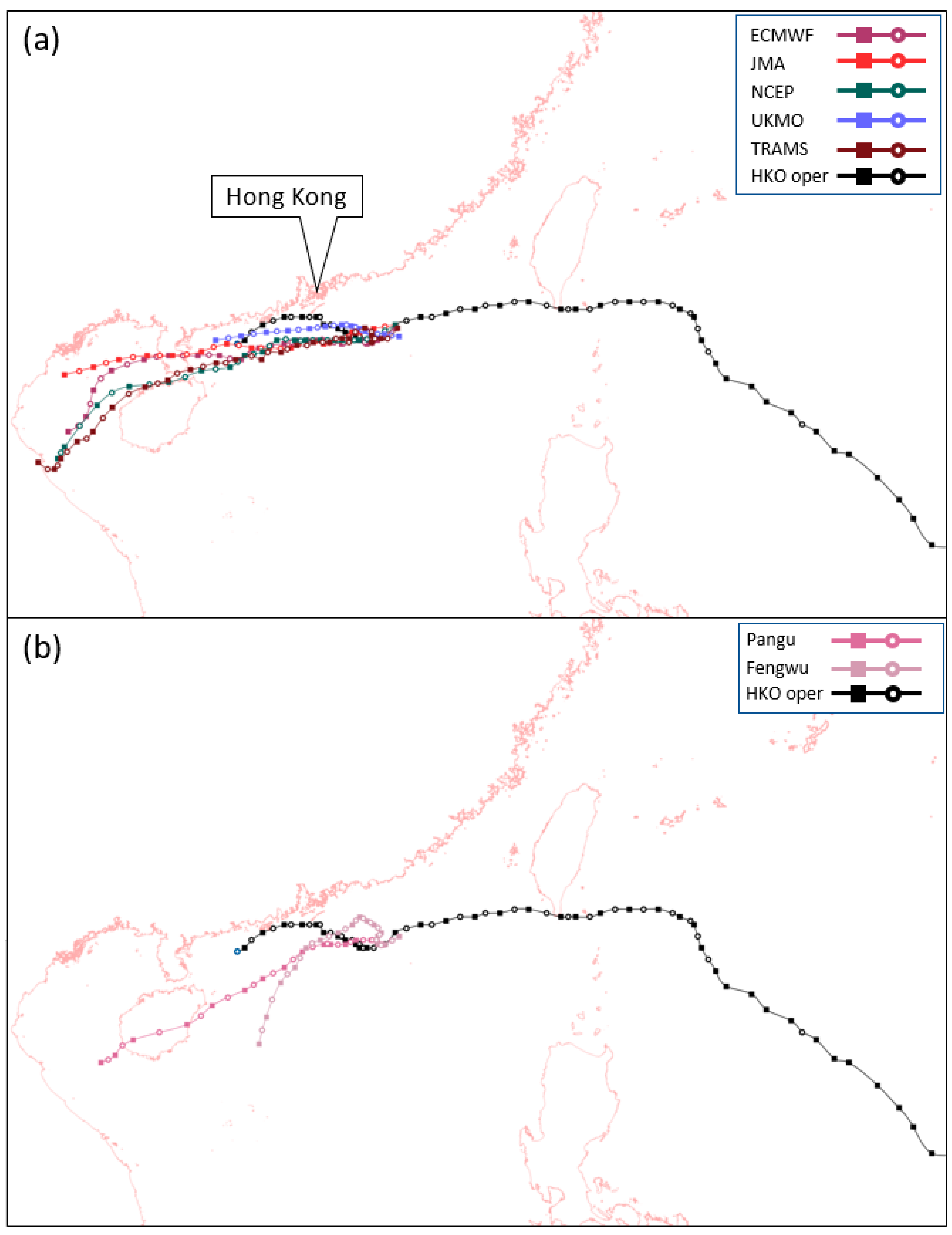
Figure 4.
ECMWF’s operational analysis of (a) 700 hPa relative humidity and winds as well as (d) mean seal-level pressure at 1200 UTC on 8 October 2023. Note that according to the HKO operational analysis, Koinu was at that time still a typhoon with central pressure 975 hPa and maximum sustained winds 75 kt. (b) and (e) 96-hour forecast of ECMWF, where Koinu was forecast to be dissipating possibly due to significant dry intrusion from the northeast monsoon; while its remaining surface vortex would have been pushed southwestwards by the monsoon. (c) and (f) TRAMS successfully forecast Koinu to remain as an intense and intact tropical cyclone at its closest to Hong Kong.
Figure 4.
ECMWF’s operational analysis of (a) 700 hPa relative humidity and winds as well as (d) mean seal-level pressure at 1200 UTC on 8 October 2023. Note that according to the HKO operational analysis, Koinu was at that time still a typhoon with central pressure 975 hPa and maximum sustained winds 75 kt. (b) and (e) 96-hour forecast of ECMWF, where Koinu was forecast to be dissipating possibly due to significant dry intrusion from the northeast monsoon; while its remaining surface vortex would have been pushed southwestwards by the monsoon. (c) and (f) TRAMS successfully forecast Koinu to remain as an intense and intact tropical cyclone at its closest to Hong Kong.
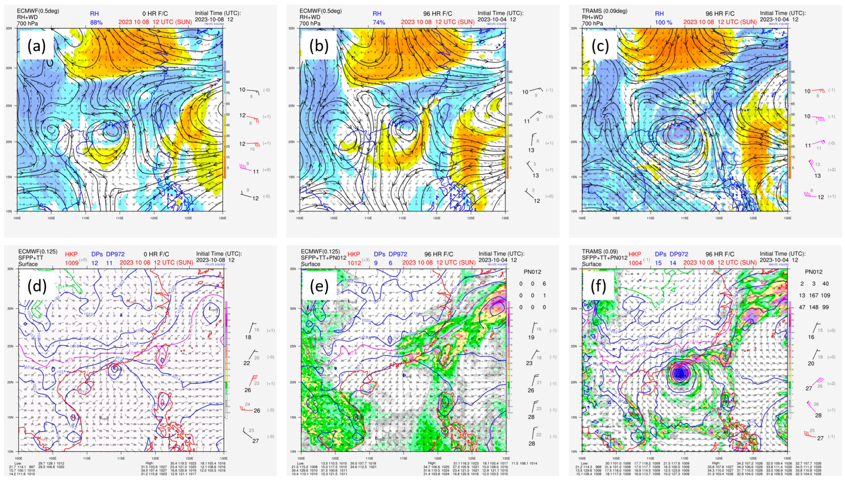
Figure 5.
ECMWF’s operational analysis of 500 hPa geopotential height at 1200 UTC on (a) 7 and (b) 8 October 2023. Note the evolution of 5910 m geopotential height contour for the establishment of a ridge over northern part of South China Sea. (c) to (e) 48-hour forecast from ECMWF, NCEP and UKMO, valid for 1200 UTC on 8 October 2023. None of these models was able to fully capture the location and strength of the ridge to the southeast of Koinu. (f) Forecast of Fengwu initialized by the operational analysis of ECMWF, where the ridge to the southeast of Koinu was most accurately forecast among available models.
Figure 5.
ECMWF’s operational analysis of 500 hPa geopotential height at 1200 UTC on (a) 7 and (b) 8 October 2023. Note the evolution of 5910 m geopotential height contour for the establishment of a ridge over northern part of South China Sea. (c) to (e) 48-hour forecast from ECMWF, NCEP and UKMO, valid for 1200 UTC on 8 October 2023. None of these models was able to fully capture the location and strength of the ridge to the southeast of Koinu. (f) Forecast of Fengwu initialized by the operational analysis of ECMWF, where the ridge to the southeast of Koinu was most accurately forecast among available models.
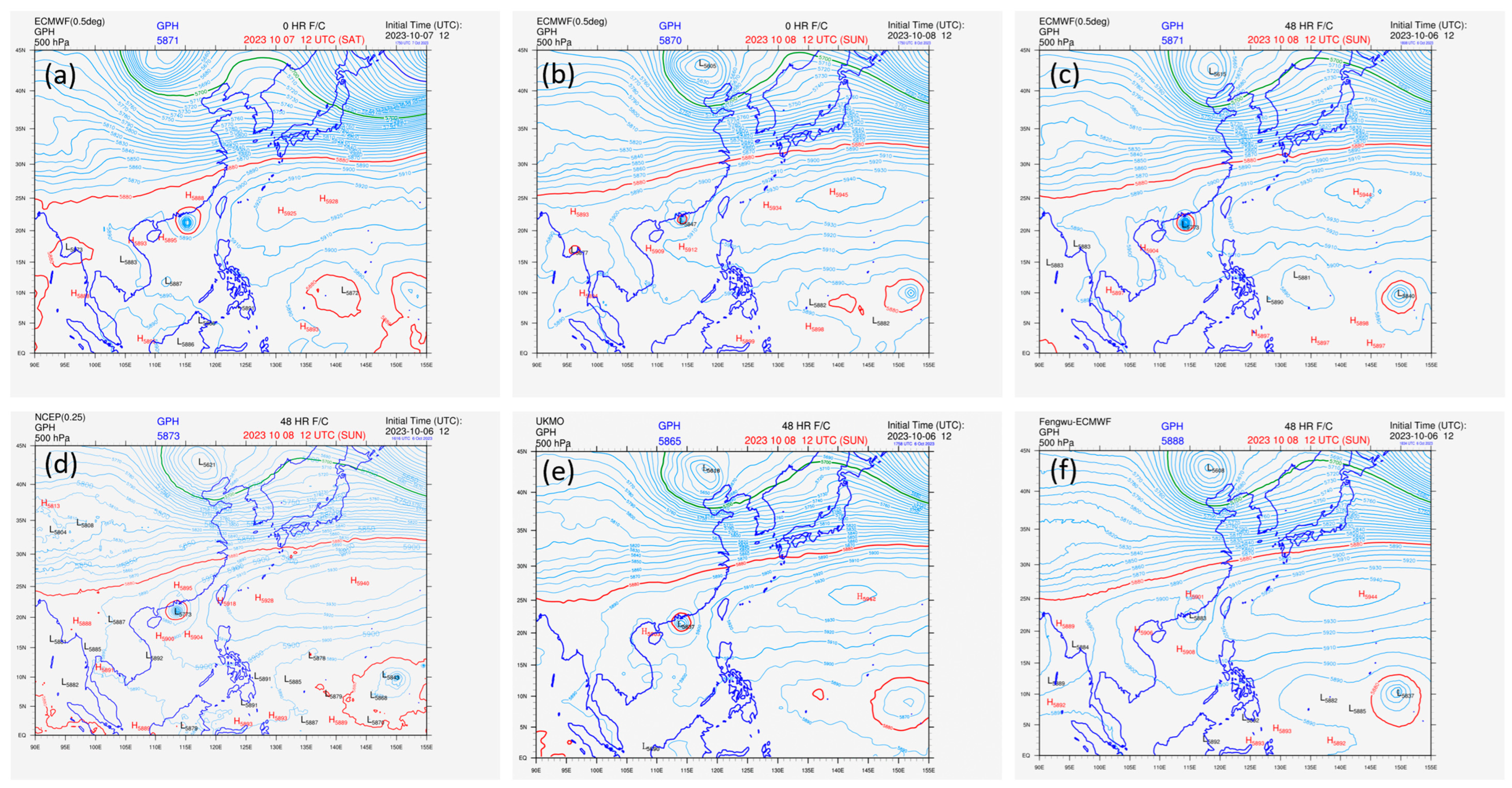
Figure 6.
EPS strike probability maps of Koinu based on the ensembles of ECMWF, NCEP and UKMO from 1200 UTC runs on 30 September, 2, 4, and 6 October 2023. Also shown is Koinu’s analysis positions (black) based on HKO operational analysis track.
Figure 6.
EPS strike probability maps of Koinu based on the ensembles of ECMWF, NCEP and UKMO from 1200 UTC runs on 30 September, 2, 4, and 6 October 2023. Also shown is Koinu’s analysis positions (black) based on HKO operational analysis track.
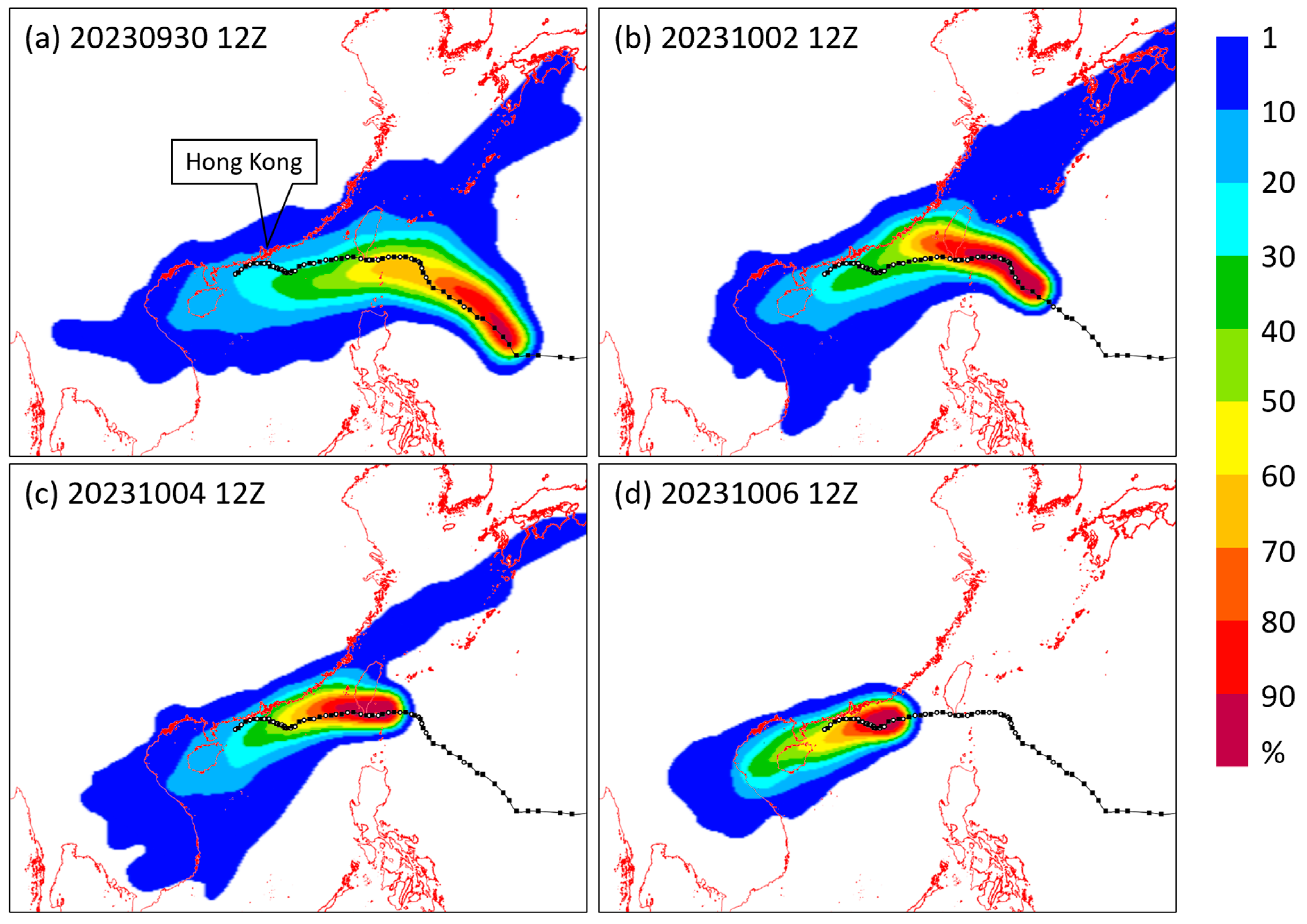
Figure 7.
Root-mean-square error of models’ forecast positions for Koinu as a function of lead time. Forecasts are verified against Koinu’s analysis positions based on HKO operational analysis track and have a common data set among different models.
Figure 7.
Root-mean-square error of models’ forecast positions for Koinu as a function of lead time. Forecasts are verified against Koinu’s analysis positions based on HKO operational analysis track and have a common data set among different models.
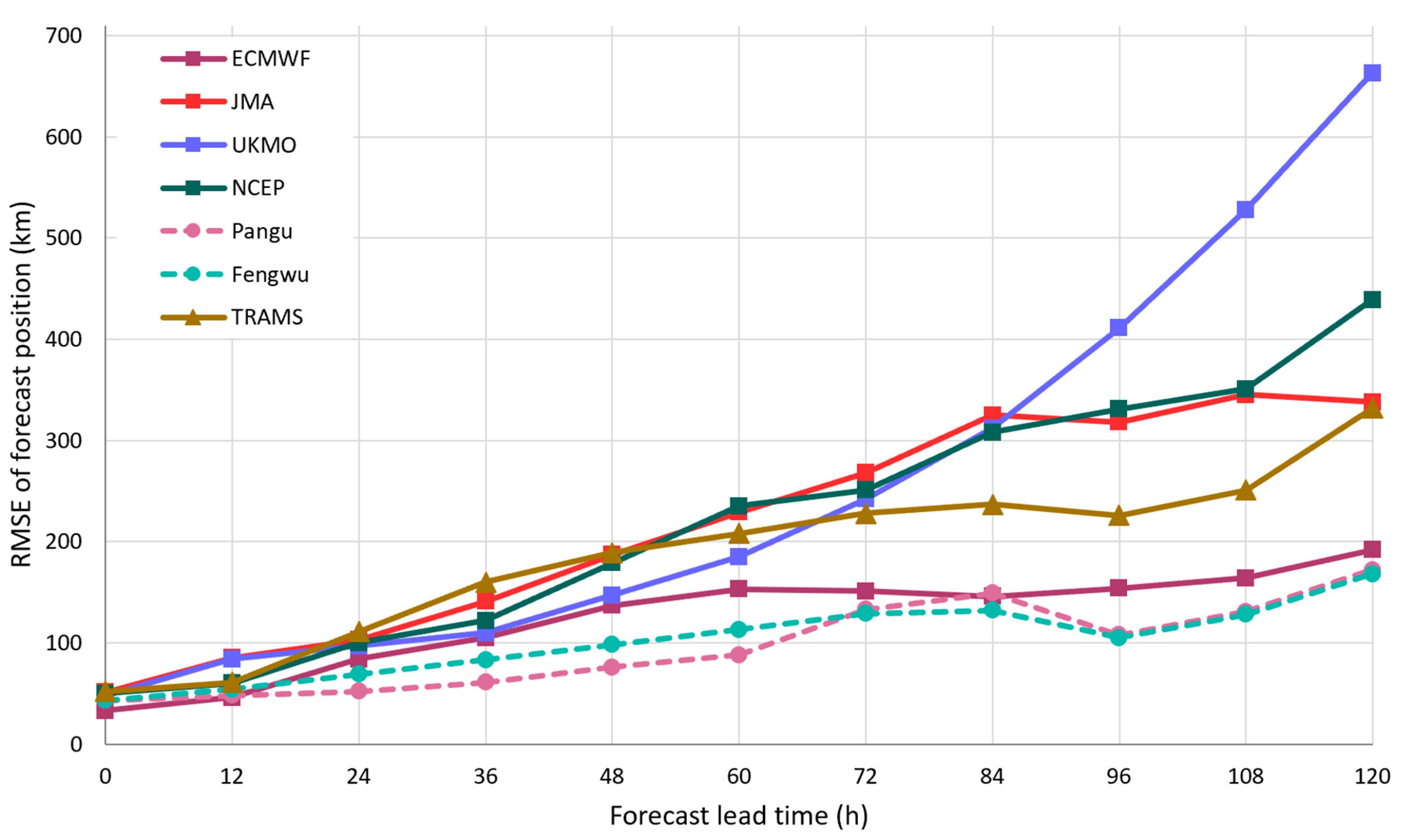
Figure 8.
Intensity of Koinu as forecast by models from 1200 UTC runs on 30 September, 2, 4, and 6 October 2023. The light-red shading indicates the spread of all available models (not shown here). Also shown is Koinu’s analysis intensity (black line) based on HKO operational analysis track. The red rectangle indicates the time period where Koinu at its closest approach to Hong Kong.
Figure 8.
Intensity of Koinu as forecast by models from 1200 UTC runs on 30 September, 2, 4, and 6 October 2023. The light-red shading indicates the spread of all available models (not shown here). Also shown is Koinu’s analysis intensity (black line) based on HKO operational analysis track. The red rectangle indicates the time period where Koinu at its closest approach to Hong Kong.
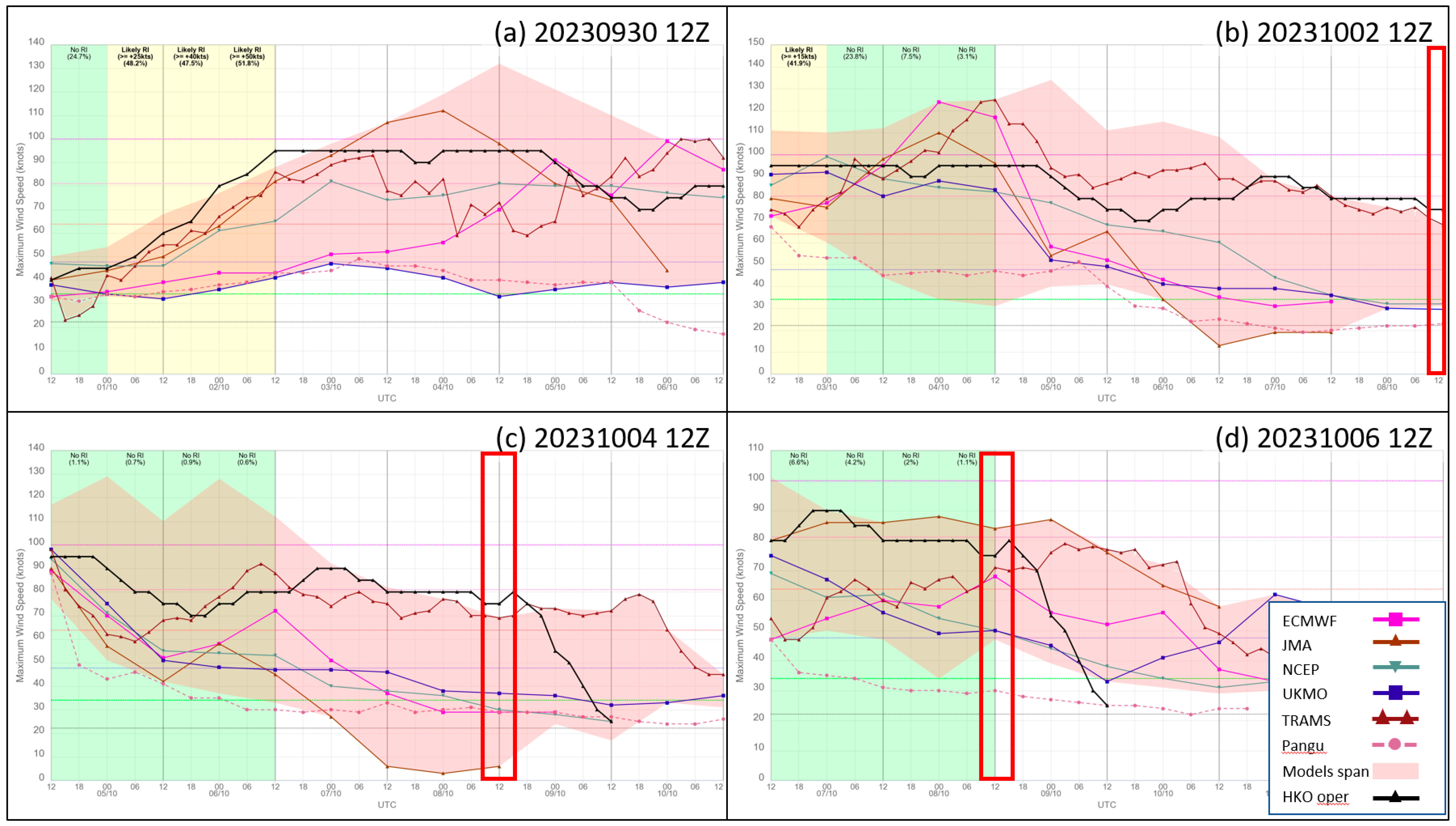
Figure 9.
Root-mean-square error of models’ forecast sustained maximum winds for Koinu as a function of lead time. Forecasts are verified against Koinu’s analysis intensity (in knots) based on HKO operational analysis track and have a common data set among models.
Figure 9.
Root-mean-square error of models’ forecast sustained maximum winds for Koinu as a function of lead time. Forecasts are verified against Koinu’s analysis intensity (in knots) based on HKO operational analysis track and have a common data set among models.
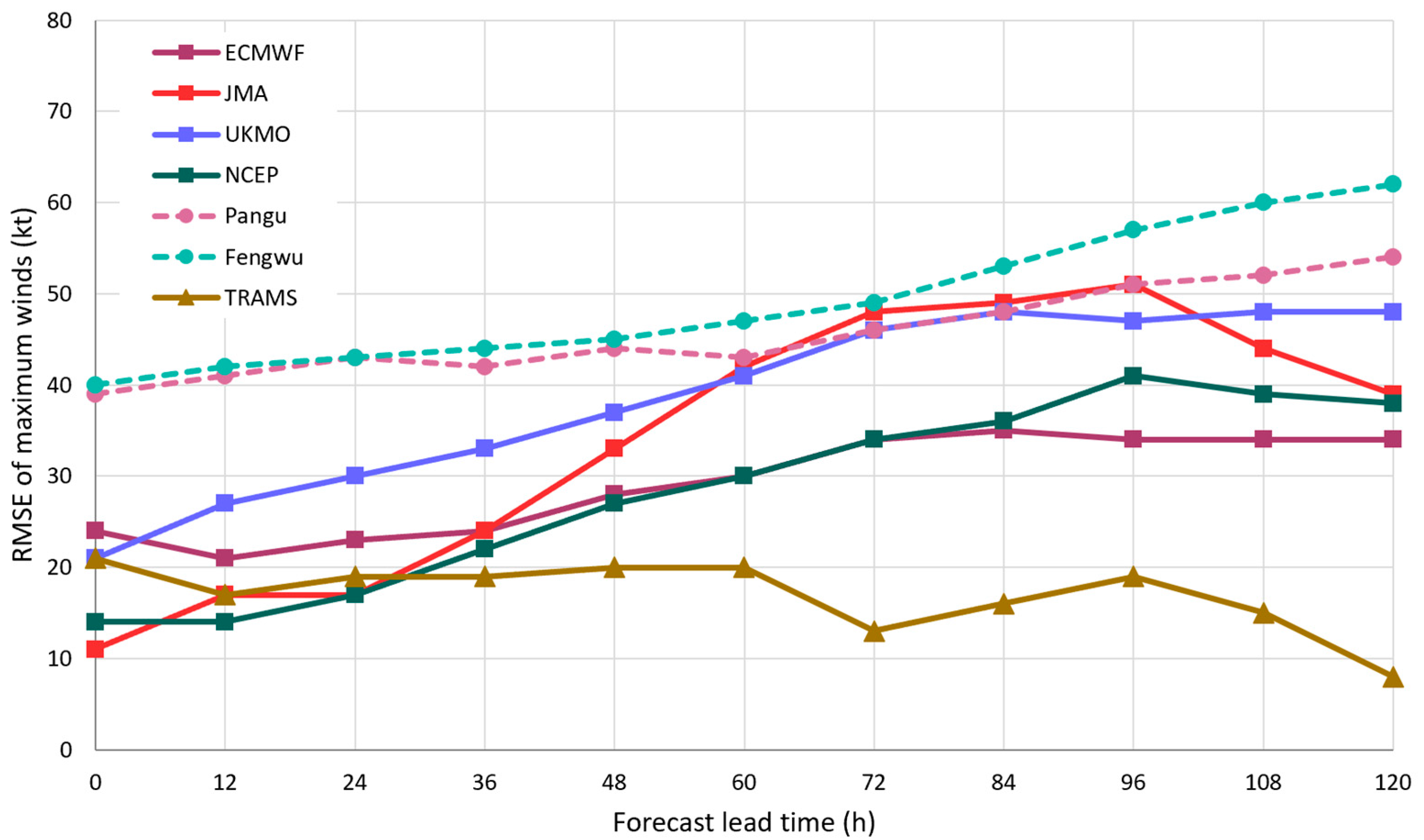
Figure 10.
Forecast surface wind fields over the Pearl River Estuary in 6-hourly intervals from 0000 UTC (leftmost column) to 1800 UTC (rightmost column) on 8 October 2023. Winds of hurricane force are coloured in yellow, which might come to the doorstep of Hong Kong. (Top row) ECMWF. (Second row) NCEP. (Third row) JMA. (Fourth row) TRAMS.
Figure 10.
Forecast surface wind fields over the Pearl River Estuary in 6-hourly intervals from 0000 UTC (leftmost column) to 1800 UTC (rightmost column) on 8 October 2023. Winds of hurricane force are coloured in yellow, which might come to the doorstep of Hong Kong. (Top row) ECMWF. (Second row) NCEP. (Third row) JMA. (Fourth row) TRAMS.
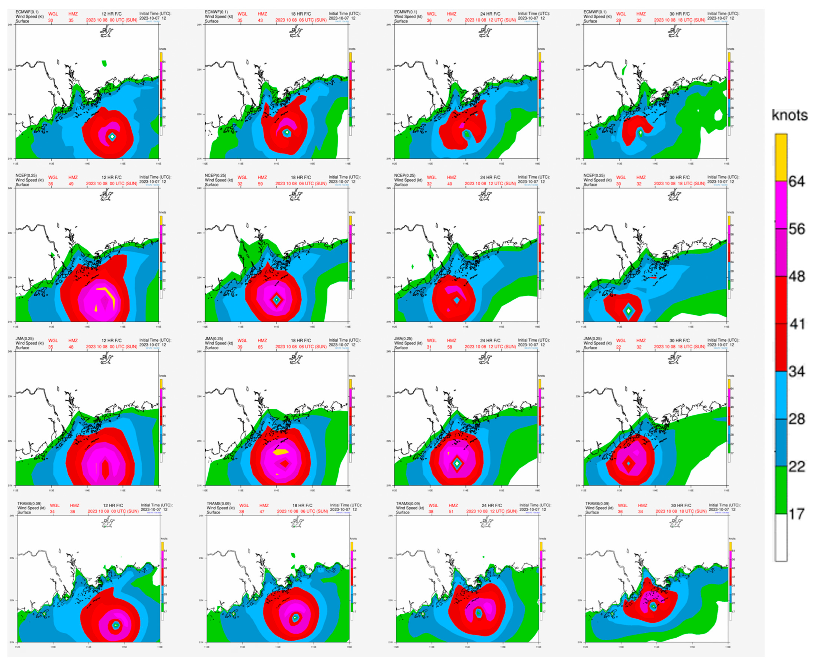
Figure 11.
(Left) Models’ 24-hour rainfall forecast for 9 October 2023, with three consecutive runs showed on the top (20231008 00Z), middle (20231007 12Z) and bottom rows (20231007 00Z). The four columns starting from the left are, respectively, ECMWF, NCEP, JMA and TRAMS. (Right) Quantitative precipitation estimation for 9 October 2023 over Hong Kong based on local rain gauges and radar data. All plots are on the same colour scale. TRAMS was able to predict to the most accurate magnitude of local rainfall on 9 October 2023 following the passage of Koinu, but its most recent run (on top row) oppositely turned down the rainfall forecast, such a wrong trend was also given by other global models.
Figure 11.
(Left) Models’ 24-hour rainfall forecast for 9 October 2023, with three consecutive runs showed on the top (20231008 00Z), middle (20231007 12Z) and bottom rows (20231007 00Z). The four columns starting from the left are, respectively, ECMWF, NCEP, JMA and TRAMS. (Right) Quantitative precipitation estimation for 9 October 2023 over Hong Kong based on local rain gauges and radar data. All plots are on the same colour scale. TRAMS was able to predict to the most accurate magnitude of local rainfall on 9 October 2023 following the passage of Koinu, but its most recent run (on top row) oppositely turned down the rainfall forecast, such a wrong trend was also given by other global models.
Disclaimer/Publisher’s Note: The statements, opinions and data contained in all publications are solely those of the individual author(s) and contributor(s) and not of MDPI and/or the editor(s). MDPI and/or the editor(s) disclaim responsibility for any injury to people or property resulting from any ideas, methods, instructions or products referred to in the content. |
© 2023 by the authors. Licensee MDPI, Basel, Switzerland. This article is an open access article distributed under the terms and conditions of the Creative Commons Attribution (CC BY) license (http://creativecommons.org/licenses/by/4.0/).
Copyright: This open access article is published under a Creative Commons CC BY 4.0 license, which permit the free download, distribution, and reuse, provided that the author and preprint are cited in any reuse.


