Submitted:
22 May 2023
Posted:
23 May 2023
Read the latest preprint version here
Abstract
Mount Hamiding Protected Forest is located in North Halmahera Regency, North Maluku Province, the Wallace zone has an important role in providing protection functions, life support systems and regulating water management, preventing floods, preventing seawater intrusion, and controlling soil fertility. The protected forest area in the Wallace Zone is globally renowned for its endemic characteristics of flora and fauna. The condition of the protected forest of Mount Hamiding HMPF is currently experiencing anthropogenic damage as a result of forest encroachment, illegal logging, shifting cultivation, grazing and poaching to meet social needs. Anthropogenic damage has been in the spotlight for decades and has become a global issue. This study aims to determine damage to protected forests, changes in land cover, and mitigation of protected forest areas. This research uses quantitative and descriptive qualitative methods. Determination of research locations by purposive sampling. Parameters measured in this study were damage to protected forests, changes in land cover and area mitigation strategies. To identify forest damage, snowball sampling was carried out, and land cover changes through land cover data processing were obtained from the Ministry of Environment and Forestry of the Republic of Indonesia. Then using Imagery 7 ETM+ and 8 OLI to calculate changes in forested land to non-forested from 2006 -2021, analysis of land cover change using supervised classification, developing a strategy based on identity verification of forest damage and analysis of land cover change. The results showed that damage to protected forests was caused by anthropogenic disturbances in the form of forest encroachment, shifting cultivation, illegal logging, grazing and hunting of wild animals. Changes in land cover experienced the greatest damage in 2006-2021 amounting to 1,796.54 ha (16.17%). Strategic efforts are carried out using forest engineering, namely the agroforestry system and social engineering through community empowerment, namely training and outreach.
Keywords:
anthropogenic
; land cover change
; mitigation
; protected forest
1. Introduction
Indonesia has the largest tropical forest in the world and is categorized as a country with very high biodiversity[1]. According to [2] that Indonesia is one of the seventeen Megadiversity countries in the world. Owned forests are natural resources that can be renewed (renewable resource), providing benefits for the community, both those who live in and around the forest. The benefits obtained are not only tangible but also intangible, forests have an important role in producing products and driving ecosystems [3]. According to [4,5,6] protected forests need attention in management because they contribute to services and sources of biodiversity.
Protected forest management policy in Indonesia refers to Law No. 41 of 1999, in which protected forests have a key role in providing protection functions, and life support systems and regulating water management, preventing floods, preventing seawater intrusion, and controlling soil fertility. regulated in government regulation No. 23 of 2021. For decades the management of protected forests has been a "highlight" due to the impact of forest destruction which has become a central issue [7], the damage that has occurred not only regionally or nationally but globally [8,9,10]. This is due to the rapid population growth [10,11, 12] with very complex social dynamics causing people living around the forest to have to make ends meet, so they carry out various activities in the forest in the form of encroachment, expansion of agricultural land [12,13], illegal logging [14], grazing [15], which have an impact on anthropogenic forest destruction.
The protected forest of Mount Hamiding on Halmahera Island, North Maluku Province, is in the Wallace zone (Appendix, Figure A1) and has a high diversity of flora and fauna because it is a protected forest located in a tropical area with a moderate climate and relatively fertile soil conditions. The Wallacea biogeographical area includes the regions of Sulawesi, Maluku and the Lesser Sundas, which are global in nature and very famous for their extraordinary endemism [16]. Mount Hamiding Protected Forest (MHPF) is a tropical forest which is located in 3 landscapes, namely the northern, central and southern parts of the Halmahera district. According to[17] in the north there are karst and structural hills, in the middle, there are active mountains and in the south, there are volcanic landscapes. Complex and varied landscape conditions create general and specific topographical uniqueness, both of which have different functions that can affect forest destruction. The slopes of Mount Apai which are general in nature with abundant and thick soil resources function as reservoirs and control flood threats so that they can function as conservative protected forest areas, while slopes which are specific in nature with steep degrees of slope with thin and rocky soil characteristics may become areas that have the potential to experience land damage, especially if it is managed into agricultural land that is not appropriate with management that is not by the principles of soil and water conservation. This protected forest has the potential for endemic fauna that does not exist elsewhere such as the Halmahera angel bird, mamoa which makes it different from other regions in Indonesia and even the world, with types of flora such as nutmeg and cloves which are characteristic of this area, but it is very unfortunate that in recent decades protected forests have experienced very sharp damage [18] as a result of very rapid population growth causing the socio-economic needs of the community to be met to increase people's income they carry out various activities that cause damage to protected forests, namely in the form of expansion of agricultural land, illegal logging, shifting cultivation through slash-and-burn activities and poaching activities in protected forest areas. The above occurs because the social and ecological aspects have not been fulfilled, resulting in a lack of harmony and harmony in the management of protected forests. Therefore, based on the phenomenon mentioned above, it is necessary to conducresearchopogenic damage to protected forest areas and preventive mitigation. The purpose of this study was to determine the damage to protected forests as a result of anthropogenic activities, the level of land cover change and preventive mitigation for the sake of sustaining climate change flora and fauna.
2. Materials and Methods
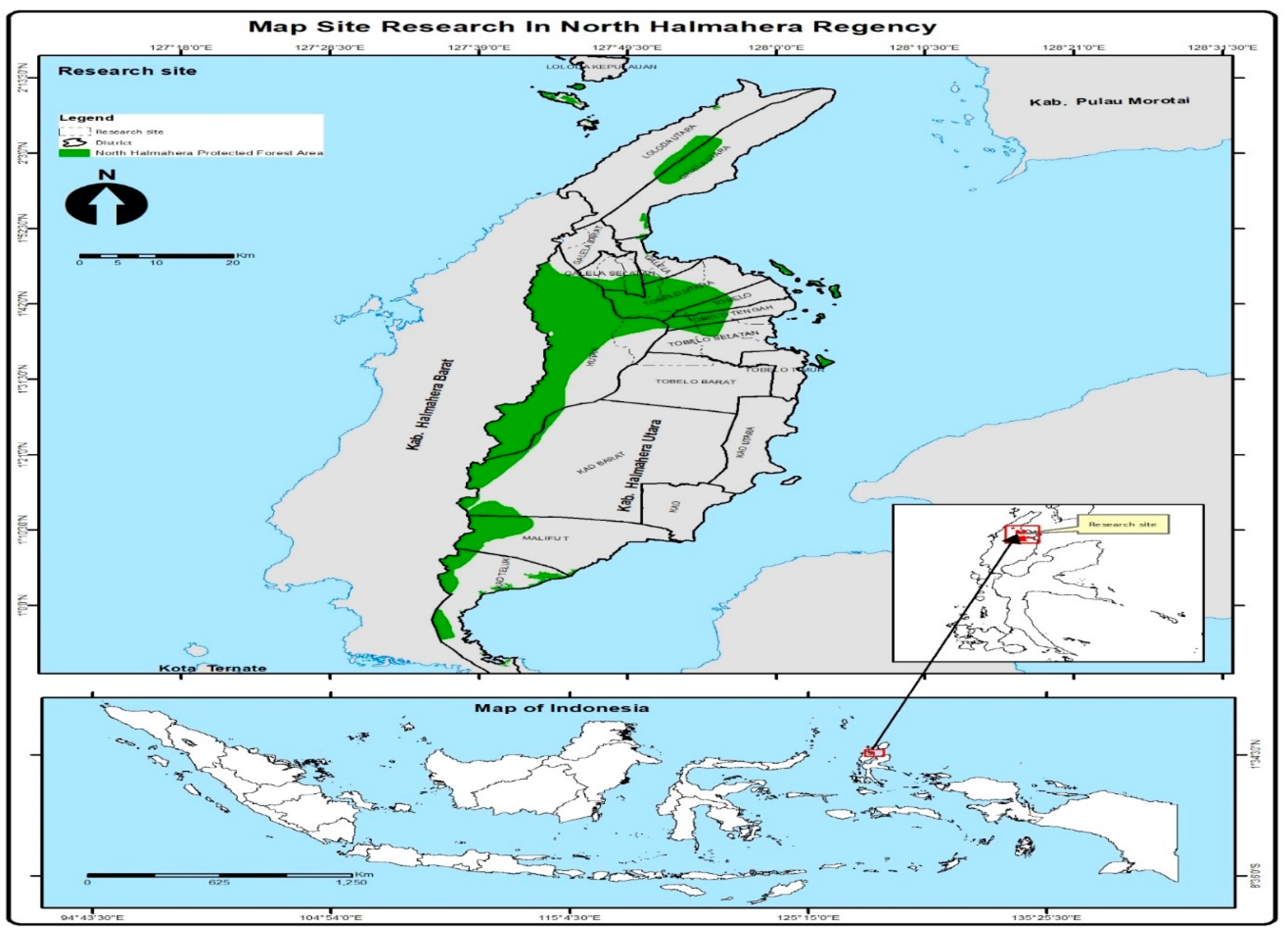
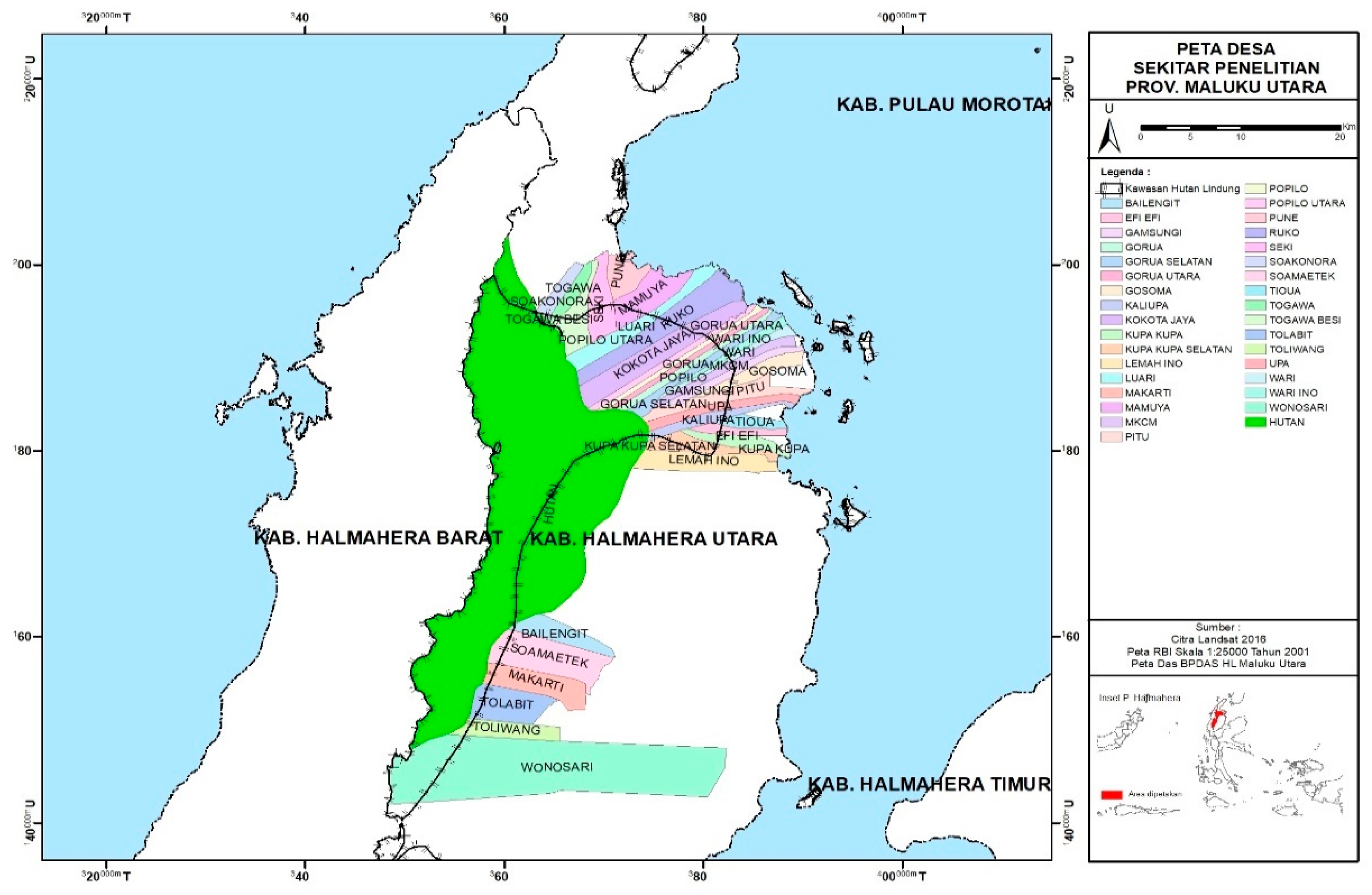
This research was conducted in the Mount Hamiding Protection Forest area in North Halahera Regency, North Maluku Province, the Wallace Zone of Indonesia. The number of villages selected as research locations was 6 villages using an intensity of 20% of the 29 villages around protected forest areas (Appendix, Figure A2). Determination of villages by considering the purposive model with the criteria that: the HMPF area is an area that is experiencing anthropogenic pressure and is administratively located in the research village and the people living in the village interact directly with the protected forest. The selected villages are the villages of Roko, Sokonora, Togawa, Mamuya, Efi -Efi and Wangongira. The research took place from July 2021 – November 2022.
Figure 1.
Research Locations.
- a.
- The research method used was qualitative research with a descriptive approach using purposive sampling and snowball sampling techniques. The purposive sampling technique is to select research locations and stakeholders involved in forest management. While the snowball sampling technique is a sampling technique that is carried out by following a snowball pattern, starting with village leaders, then community leaders so that the information obtained is accurate regarding biophysical conditions, and forest damage and then the search for information will stop if the informant provides the same information as previous informants by the research objectives. The data was collected through in-depth interviews with informants and observing people's daily lives as well as forest damage and the causes of the damage.
- b.
- The data collected is in the form of primary data and secondary data. Primary data is in the form of interviews with informants about forest damage, secondary data includes village profiles and potential, and information retrieval from scientific journal references to complement primary data. Data collection techniques through interviews, observation and literature studies. Interviews, namely data collection techniques through question and answer with informants about forest damage, documentation, namely methods of collecting data by looking at the activities that cause damage and taking pictures of damaged areas and studying documents from the village office and at the FMU office
- c.
-
Spatial analysis
-
Changes in land coverTools and materials. The tools and materials used in this study were ArcGIS 10, series 10.4, a set of computer hardware, GPS, Landsat 7 ETM+ and Landsat 8 OLI satellite imagery of the forest area of Halmahera Island in 2006, 2011, 2016, 2021, a map of the North Halmahera area.
-
The procedure for making mapsAccording to [19] that the condition of land cover is very closely related to the pattern of land use that develops in an area. For processing land cover data obtained from the Ministry of Environment and Forestry of the Republic of Indonesia. Furthermore, using Landsat 7 ETM+ and 8 OLI imagery to calculate changes in forested land to non-forested land from 2006, 2011, 2016 and 2021. The method used is supervised classification with the maximum likelihood algorithm[15,16]. According to [20] the procedure for making a map is shown in Figure 2.
-
3. Results
The findings in the field show that the damage to HMPF is caused by anthropogenic activities; encroachment by the community, expansion of agricultural land, illegal logging and hunting of wild animals.
3.1. Anthropogenic Activity
Globally, forest ecosystems that are rich in biodiversity face the risk of land use change due to forest destruction from anthropogenic activities. Damage to protected forests due to anthropogenic activities affects the composition of forest vegetation structures [21]. This section may be divided into subheadings. It should provide a concise and precise description of the experimental results, their interpretation, as well as the experimental conclusions that can be drawn.
3.2. Figures, Tables and Schemes
Figure 3.
Land Use Map for 2006 -2021.
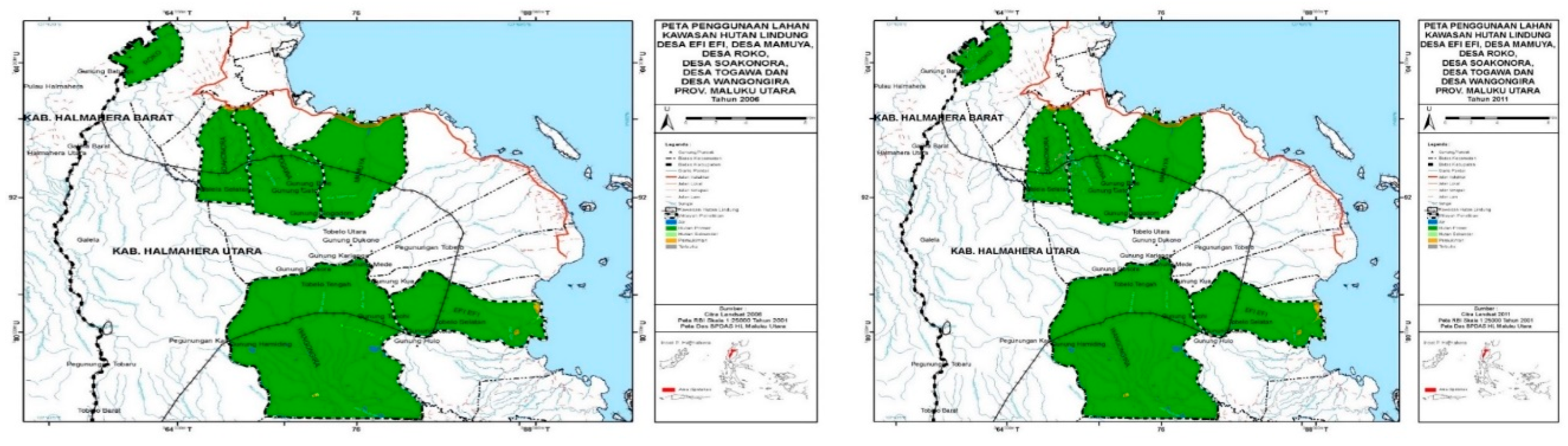
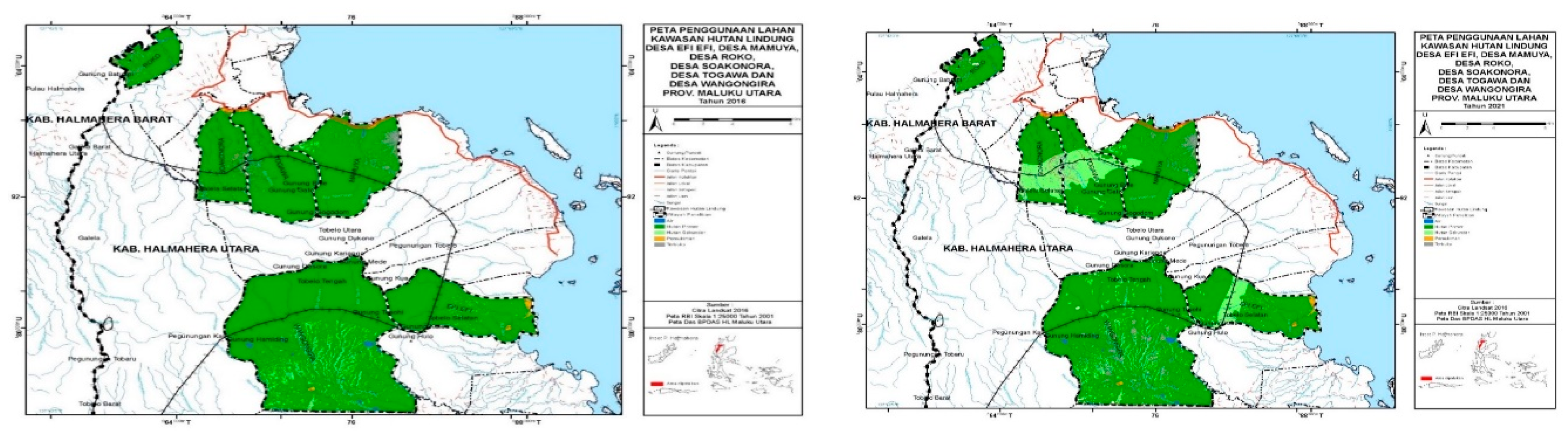
Figure 4.
Map of land cover change in the HMPF area in 2006 – 2021.
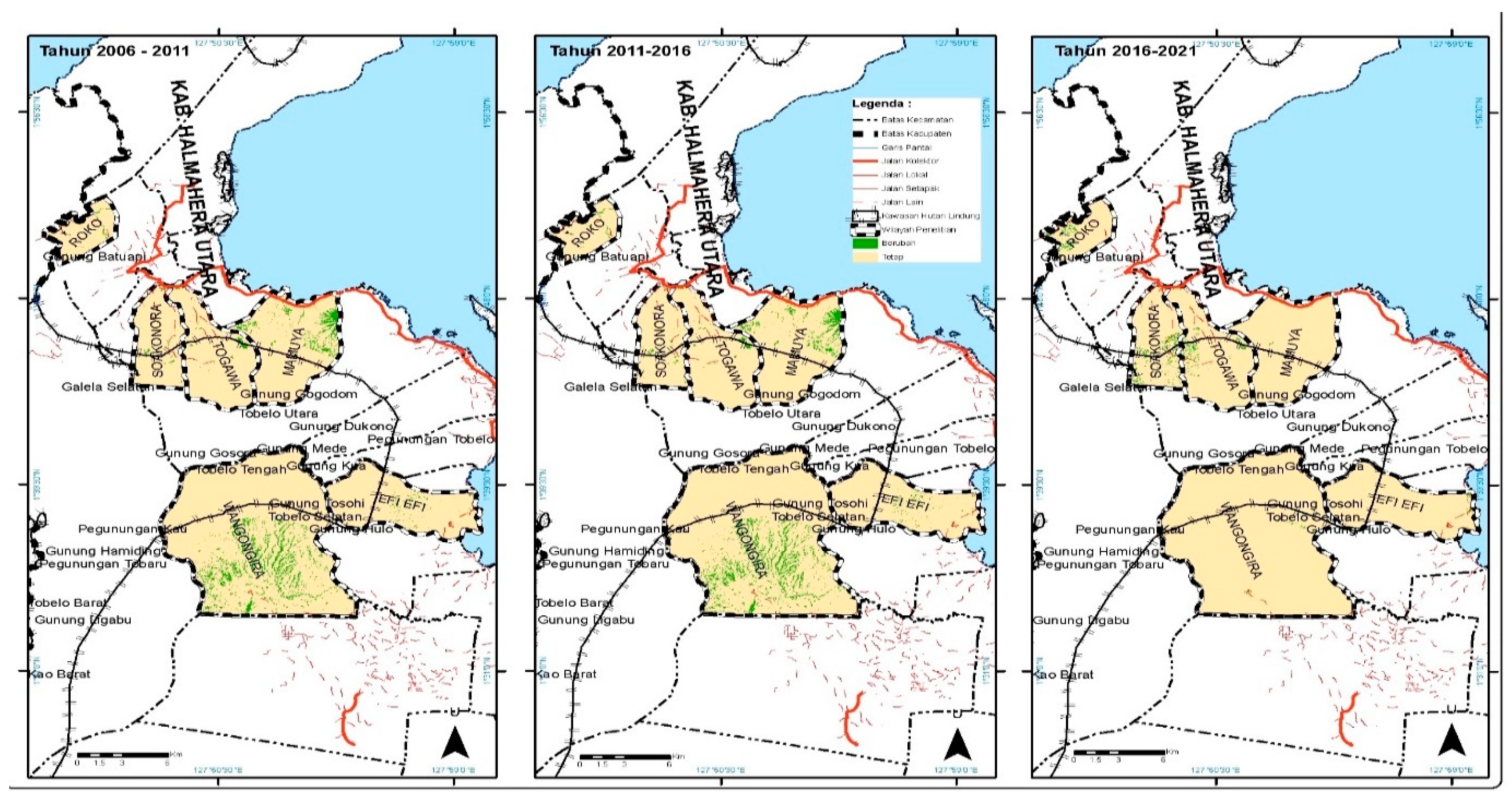

Table 1.
Changes in land cover 2006-2011.
| Village name | 2006 | 2011 | Percentage | Fixed/Changed | |||
|---|---|---|---|---|---|---|---|
| Primary | Secondary | Open | Ha | ||||
| Roko | Primary | Primary | 29.35 | 0.26 | Fixed | ||
| Roko | Primary | Open | 5.46 | 0.05 | Changed | ||
| Soakonora | Primary | Primary | 932.01 | 8.39 | Fixed | ||
| Soakonora | Primary | Secondary | 5,41 | 0.05 | Changed | ||
| Soakonora | Primary | Open | 72.64 | 0.65 | Changed | ||
| Soakonora | Secondary | Secondary | 2.69 | 0.02 | Fixed | ||
| Togawa | Primary | Primary | 2,472.58 | 22.26 | Fixed | ||
| Togawa | Primary | Secondary | 17.39 | 0.16 | Changed | ||
| Togawa | Primary | Open | 48.26 | 0.43 | Changed | ||
| Togawa | Secondary | Secondary | 6.31 | 0.06 | Fixed | ||
| Mamuya | Primary | Primary | 1,567.96 | 14.12 | Fixed | ||
| Efi-Efi | Primary | Primary | 1,501.04 | 13.51 | Fixed | ||
| Wangongira | Primary | Primary | 4,446.69 | 40.03 | Fixed | ||
| The total area of HMPF | 11,107.81 | 100 | |||||
| Changes in the area of protected forest | 76.81 | 0.69 | |||||
* Source: Primary data processing, 2022.
Table 2.
Changes in land cover 2011 – 2016.
| Village name | 2011 | 2016 | Percentage | Fixed/Changed | |||
|---|---|---|---|---|---|---|---|
| Primary | Secondary | Open | Ha | ||||
| Roko | Primary | Primary | 29.35 | 0.26 | Fixed | ||
| Roko | Open | Open | 5.46 | 0.05 | Fixed | ||
| Soakonora | Primary | Primary | 932.01 | 8.39 | Fixed | ||
| Soakonora | Secondary | Primary | 8.10 | 0.07 | Changed | ||
| Soakonora | Open | Open | 72.64 | 0.65 | Changed | ||
| Togawa | Primary | Primary | 2,472.58 | 22.26 | Fixed | ||
| Togawa | Secondary | Primary | 23.71 | 0.21 | Changed | ||
| Togawa | Open | Open | 48.26 | 0.43 | Fixed | ||
| Mamuya | Primary | Primary | 1,567.96 | 14.12 | Fixed | ||
| Efi Efi | Primary | Primary | 1,501.04 | 13.51 | Fixed | ||
| Wangongira | Primary | Primary | 4,446.69 | 40.03 | Fixed | ||
| The total area of HMPF | 11,107.81 | 100 | |||||
| Changes in the area of protected forest | 31.81 | 0.29 | |||||
* Source: Primary data processing, 2022.
Table 3.
Changes in land cover 2016 - 2021.
| Village name | 2016 | 2021 | Percentage | Fixed/Changed | |||
|---|---|---|---|---|---|---|---|
| Primary | Secondary | Open | Ha | ||||
| Roko | Primary | Primary | 29.35 | 0.26 | Fixed | ||
| Roko | Open | Open | 5.46 | 0.05 | Fixed | ||
| Soakonora | Primary | Primary | 344.37 | 3,10 | Fixed | ||
| Soakonora | Primary | Secondary | 595.74 | 5.36 | Changed | ||
| Soakonora | Open | Open | 72.64 | 0.65 | Fixed | ||
| Togawa | Primary | Primary | 1,687.55 | 15.19 | Fixed | ||
| Togawa | Primary | Secondary | 805.49 | 7.25 | Changed | ||
| Togawa | Primary | Grass | 3.25 | 0.03 | Changed | ||
| Togawa | Open | Open | 48.26 | 0.43 | Fixed | ||
| Mamuya | Primary | Primary | 1,559.52 | 14.04 | Fixed | ||
| Mamuya | Primary | Secondary | 8.44 | 0.08 | Changed | ||
| Efi Efi | Primary | Primary | 1,263.47 | 11.37 | Fixed | ||
| Efi Efi | Primary | Secondary | 237.57 | 2.13 | Changed | ||
| Wangongira | Primary | Primary | 4,300.65 | 38.72 | Fixed | ||
| Wangongira | Primary | Secondary | Secondary | 133.60 | 1.20 | Changed | |
| Wangongira | Primary | Grass | 12.44 | 0.11 | Changed | ||
| The total area of HMPF | 11,107.81 | 100 | |||||
| Changes in the area of protected forest | 1,796.54 | 16.17 | |||||
* Source: Primary data processing, 2022.
4. Discussion
4.1. Anthropogenic Damage
- a.
- Forest Encroachment
Globally, forest ecosystems that are rich in biodiversity face the risk of land use change due to forest destruction from anthropogenic activities. Forest damage due to anthropogenic activities affects the composition of forest vegetation structures [18,19,22]. Therefore understanding the role of anthropogenic factors in influencing the composition of forest ecosystems and vegetation is a prerequisite for the conservation and sustainable management of forest ecosystems[23]. Based on the findings in the field anthropogenic factors; Forest encroachment, shifting cultivation, illegal logging, livestock grazing and hunting affect the damage to protected forests which can be explained below. According to [24] that there is damage to protected forest areas due to demographic pressures, namely population growth, the inaccuracy of sustainable forest resource conservation programs and improving the standard of living of communities living in and around forests. The implementation of strategies to conserve forest resources must take into account the socio-economic context of the local community. Forest Encroachment
Encroachment activities on protected forests carried out by the community result from the community's high dependence on forests, this is caused by pressure from economic and social factors [25]. The economic factor is that the people in the HMPF area on average still live below the poverty line so to increase family income the community expands the land to be managed by encroaching on the forest, this is in line with the results of research from [26]. The area owned by the community is an average of 2.15 ha/person. Due to the increasing need, people are opening up new land for planting with coconut (Coco nucifera) as the prima donna crop because the coconut maintenance system is not too difficult and spices such as nutmeg (Myristica fragrans) and cloves (Zyzygium aromaticum) so that can meet family needs, this is in line with the statement of [25] that encroachment activities occur due to pressure from the need, forcing people to open new land to meet family needs. Based on the results of interviews in the field with Mr Harun as the traditional leader in Soakonara village, it is customary for the community to clear forest areas with the term "renting", when someone rents the area into their own to manage and other people cannot manage the land without obtaining the permission of the person concerned. Encroachment activities are carried out because the control function of the FMU is lacking/weak in the field, as well as the community's knowledge about protected forests is very minimal, this is due to a lack of socialization and a very low level of community education. The very low level of education where most people have graduated from elementary school causes most of the people to have a livelihood as farmers because getting a job as a civil servant or private is rather difficult because the level of education does not support getting jobs that require knowledge (science). and skills. Conditions with a limited land area and the average community having a job as a copra farmer, are very dependent on the harvest every 4 months, even when the coconuts have not been harvested, farmers have borrowed money from bonded bonds or middlemen. This is what forces farmers to open new land by encroaching on forests known as renters because they feel that the land they own will not meet their needs with the production results obtained, while bananas and tubers, such as cassava, sweet potatoes are planted, the average result for daily consumption needs (subsistence).
Based on the results of field interviews with Mr. Pascal Lumbol the head of the North Halmahera FMU planning department, the obstacles in carrying out monitoring activities in the field were due to limited facilities and costs for operational activities in the field. Based on the results of an interview with Mr Ul Lemon the secretary of the social forestry group in the village of Soakonora that in 1999 the area was determined to become a protected forest area, but long before the designation of the protected forest area become an HMPF area the community already had a garden in that area, the community garden was located in the middle – in the middle of a protected forest area, so this has become a problem with the North Halmahera District forestry service which has now become the UPT of the North Maluku Provincial Forestry Service or known as the FMU so that until now this has been a problem that has never been resolved. This causes the protected forest area to become damaged because the community continues to clear the area authors should discuss the results and how they can be interpreted from the perspective of previous studies and of the working hypotheses. The findings and their implications should be discussed in the broadest context possible. Future research directions may also be highlighted.
- b.
- Shifting Cultivation
Shifting cultivation using a slash-and-burn system has become a hereditary habit [27]. Based on the findings in the field, the community practised shifting cultivation because it was a habit, where when the land planted with agricultural crops was felt to be less fertile, the community would open up new areas for agricultural land. This is done by cutting down trees/vegetation in protected forest areas to make gardens, and shifting cultivation activities that are carried out after encroachment activities. Slash-and-burn activities are usually carried out at the end of the summer, from August to September, while planting activities are usually at the beginning of the rainy season in October. The types of plants commonly planted are coconut, nutmeg, cloves and sweet potatoes; cassava, and sweet potato. As a result of the shifting cultivation system, it causes damage to the forest, especially its biophysical condition. According to [28] that the agricultural model in North Maluku is agriculture without grain crops where people use machetes, hoes and crowbars as tools for planting activities on the land because the staple food is tubers (cassava, sweet potato, taro, kemble), bananas, breadfruit and sago. The managed land is called a hamlet formed with a shifting cultivation system. The land is managed by all family members but the system of inheritance and ownership is a patriarchal system. The system of fruit crops with food crops or spice plants with food crops and coconut, nutmeg, cloves and food crops is a transitional system from forest to fruit or spice plantations. The sedentary system of coconuts, tubers and bananas is a system in which shifting cultivation is no longer practised and farmers have to live off the fields. The dominant tubers are sweet potatoes (Discorea alata), kemble (Discorea esculentum), cassava (Manihot esculenta), and sweet potatoes (Ipomoea batatas). According to the results of previous studies in developing or developed countries, the largest percentage of forest damage is due to human activities [29] and affects biodiversity.
- c.
- Illegal logging
Forests can provide benefits for humans both directly and indirectly if managed properly, recently forests have experienced increasingly sharp damage as a result of irresponsible management, namely in the form of illegal logging at research sites caused by logging activities, logging what was carried out was not only from the people living in the village where the author conducted the research but also illegal loggers from people from outside the village where the writer conducted the research, namely other villages/neighbouring villages. The felled wood is then sold by the chain saw operator and distributed to the wood storage which will then be sold in the form of processed wood, in the form of boards measuring 25 cm x 2.5 cm x 4 m, beams 5 cm x 5 cm x 4 m and 5 cm x 10cm x 4m.
Based on the findings in the field through interviews that illegal loggers carry out illegal logging, as a result of economic factors to meet their daily needs, a lack of understanding about the existence of protected forests and logging activities has become a habit, these findings are in line with the opinion of [23,24]. Illegal logging is a very complex crime, so early prevention efforts are needed, both in the form of a penalty (criminal law) and non-penalty (outside of criminal law). This is felt necessary because the impact of illegal logging is not only bad for the economic sector but also for damage to the vegetation ecosystem in the forest for mature trees which can provide seeds for tree growth regeneration even for endemic bird species that will migrate to other places, and also threats to the types of animals that make forests their habitats; such as maleu birds, deer and so on [30]. Forest damage that occurs due to illegal logging is influenced by economic factors to meet the needs of life, limited knowledge about protected forest areas, and accessibility, namely with open road access to the forest making it easier for people to carry out illegal logging activities [31]
- d.
- Herding and poaching
Based on findings in the field people who raise livestock such as; buffalo, cows or goats with a wild release system, in which livestock consume feed/grass on their land, and often enter other people's land. This has an impact on forest destruction because it will have an impact on damage to tree vegetation and tillers in protected forest areas, even soil compaction occurs in surrounding locations or places where cows are tethered or tied to trees, this is in line with the results of research from [32]. According to [33,34] grazing also triggers forest destruction.
In village locations that are difficult to reach because access is so difficult, such as the case in Wangongira village, it is a threat to endemic animal species. The results of interviews with the head of Wangongira village show that the community usually hunts pigs and deer, besides that the community also makes natural traps to catch birds and look for mamoa bird eggs in protected forests to meet their meat consumption needs. If this happens continuously, endemic animals will in the HMPF area become extinct, therefore the community needs to be empowered through outreach and training activities so that they understand the importance of the existence of protected forests and forest resources so that their utilization can sustainably take place and improve the community's economy. The following shows the hunting habits practised by the community. According to [35] For more than 40 thousand years, people who subsisted on hunting played an active part in the tropics, but as hunting methods became more efficient in the last century, the ability to catch large numbers of animals has also increased. Over-hunting for bushmeat can threaten food security if certain species are over-harvested. The impact is huge because at least 300 million of the world’s poor depend on forests for their livelihoods and 90 per cent of the world's poorest people depend on forests.
4.2. Land Cover Change
Changes in HMPF land cover in 2006 – 2001 can be seen in Table 1. Based on the results of image analysis of HMPF land use maps, protected forests are classified into 2, namely primary forest and secondary forest, which can be explained in detail as follows; The area of protected forest in Roko village consists of 29.35 ha (0.26%) of primary forest and 5.46 ha (0.05%) of primary forest that has been converted into open areas. The protected forest area in Soakonora village consists of primary forest and secondary forest, the primary forest area is 932.01 ha (8.39%), while the primary forest area is 5.41 ha (0.05%) which has been turned into secondary forest. then a primary forest of 72.64 ha (0.65%) turned into an open area, while a secondary forest with an area of 2.69 (0.02%) existed before 2006. The protected area in Togawa village consists of primary forest and secondary. Primary forest owned by an area of 2,472.58 (22.66%), some of the primary forest with an area of 17.39 ha (0.16%) has turned into secondary forest, some of it is a primary forest with an area of 48.26 ha (0.16%) 43%) has become an open area, while the secondary forest that is owned is 6.31 ha (0.06%). In Mamuya, Efi-Efi and Wangongira villages the protected forest is primary forest, with details of the area being primary forest in Mamuya village with an area of 1,567.96 ha (14.12%), Efi-Efi 1,501.04 ha (13.51 %) and Wangongira 4,446.69 ha (40.03%).
The results of the analysis in the six villages illustrate that the largest change in the protected forest area was in Soakonoro village, then Togawa and Roko villages as a result of the expansion of the protected forest into agricultural land.
Changes in land cover in 2011-2016 can be seen in Table 2. The classification of protected forest at the research location can be divided into 2, namely primary and secondary forest. The results of the analysis of the area of the HMPF area for each village are as follows; Roko Village has a protected forest area consisting of 29.35 ha (0.26%) primary forest, and 5.46 ha (0.05%) primary protected forest with open conditions. Soakonora Village has a primary forest with an area of 932.01 (8.39%) and a secondary forest with an area of 8.10 (0.07%) that has been converted into a primary forest. The open area with an area of 72.64 ha (0.65%) did not change. Togawa Village has a protected forest classified as a primary forest covering an area of 2,472.58 ha (22.26%), and a secondary forest of 23.71 ha (0.21%) has been turned into a primary forest. Protected forest classified as primary forest in Mamuya village with an area of 1,567.96 (14.21%), in Efi - Efi village with an area of 1,501.04 ha (5.05%) and Wangongira village with an area of 4,446.69 ha (14.96 %) did not change. The results of the analysis illustrate that the protected forest area has turned into a primary forest due to the rehabilitation activities that have been carried out by the community together with the River Basin Management Office.
Data on land cover change for 2016 -2021 can be seen in Table 3. The results of the analysis of land cover change show that the classification of protected forest at the study site is divided into primary, secondary, open and grass forests. Changes in land cover for each village can be broken down as follows: Roko village has a primary forest area of 29.35 (2.6%) and an open area of 5.46 (0.05%). In Sokonora village, the primary forest is 344.37 ha (3.10%), while the primary forest that has turned into the secondary forest is 595.75 (5.36%), protected forest in open conditions 72.64 (0.65%). Togawa Village has a primary forest with an area of 1,687.55 ha (15.19%), while the primary forest has turned into a secondary forest of 805.49 (7.25%), the primary forest has turned into a grassy area of 3.25 ha (0.03%) and protected forest in open conditions with an area of 48.26 ha (0.43%). In Mamuya village, the primary forest is 1,559.52 ha (14.04%), while the primary forest area is 8.44 ha (0.88%) which has been converted into a secondary forest. The primary forest in the village of Efi - Efi covers an area of 1263.47 (11.37%), while the primary forest with an area of 237.57 ha (2.13%) has been transformed into a secondary forest. The condition of the protected forest area in Wangongira village has a primary forest with an area of 4,300.65 ha (38.72%), a primary forest with an area of 133.60 ha (1.20%) has turned into a secondary forest and a primary forest with an area of 12.44 ha (0.11%) has turned into a grassy area. Based on the results of the analysis above, illustrates that the total change in protected forest area was 1,796.54 (16.17%) as a result of forest encroachment activities, expansion of agricultural land, illegal logging and grazing and poaching.
Based on the data obtained through the overlay of the land use change map from 2006 – 2021 in Figure 4, it gives an illustration that the change in land cover from 2006 – 2011 was 76.53 ha (0.69%), details of changes can be seen in Table 1. The change in land cover from 2011 – 2016 of 31.81 ha (0.29%) from secondary forest to primary forest can be seen in Table 2. This shows that forest rehabilitation activities have been carried out. Changes in land cover from 2016 – 2021 of 1796.54 ha (16.17%) can be seen in Table 3. Based on the data obtained, it shows that the highest level of land cover change was in 2016 – 2021. As a protected forest area, then the HMPF area must be managed according to its function by involving the community in a participatory manner. According to [36] that the neglect of social problems in forest management has led to resistance from the community with forest encroachment, shifting cultivation, illegal logging and livestock grazing. As a result of this anthropogenic activity, the area of protected forest has decreased. The change in forest cover to non-forest illustrates that forests have changed the form of land cover to plantations, agriculture, settlements, shrubs and so on.
Changes in forest cover are one of the contemporary environmental changes due to human activities that have a global impact and affect the earth's ecosystems. Forests are damaged due to encroachment, illegal logging and shifting cultivation, this is due to the increasing population, thus expanding land to meet basic needs. The problem of population growth and the economy becomes a benchmark in the process of forest destruction. The consequences of this damage have an impact on the environment which can cause flood and erosion hazards as well as global warming.
4.3. Mitigation of preventing HMPF damage with the Social Forestry Strategy in HMPF Management with the Community
According to [37] that the key to overcoming the problem of forest destruction is the need for mitigation efforts. Therefore, based on information about forest destruction and changes in land cover, it is beneficial for plans to develop protected forests [38]. Based on the problems of HMPF management in North Halmahera Regency as described above, the objectives of developing a protected forest are as follows:
- Increasing productivity in forest areas in the form of non-timber forest products and environmental services.
- Improving the standard of living and welfare of communities living around forest areas by involving community participation in forest management
- Realizing forest management while still paying attention to its main function as a regulator of water management, flood and erosion control through a forest ecosystem management (FEM) approach.
- Supporting regional development as an integral part of national development in the framework of the development of the Indonesian people as a whole and the development of all Indonesian people.
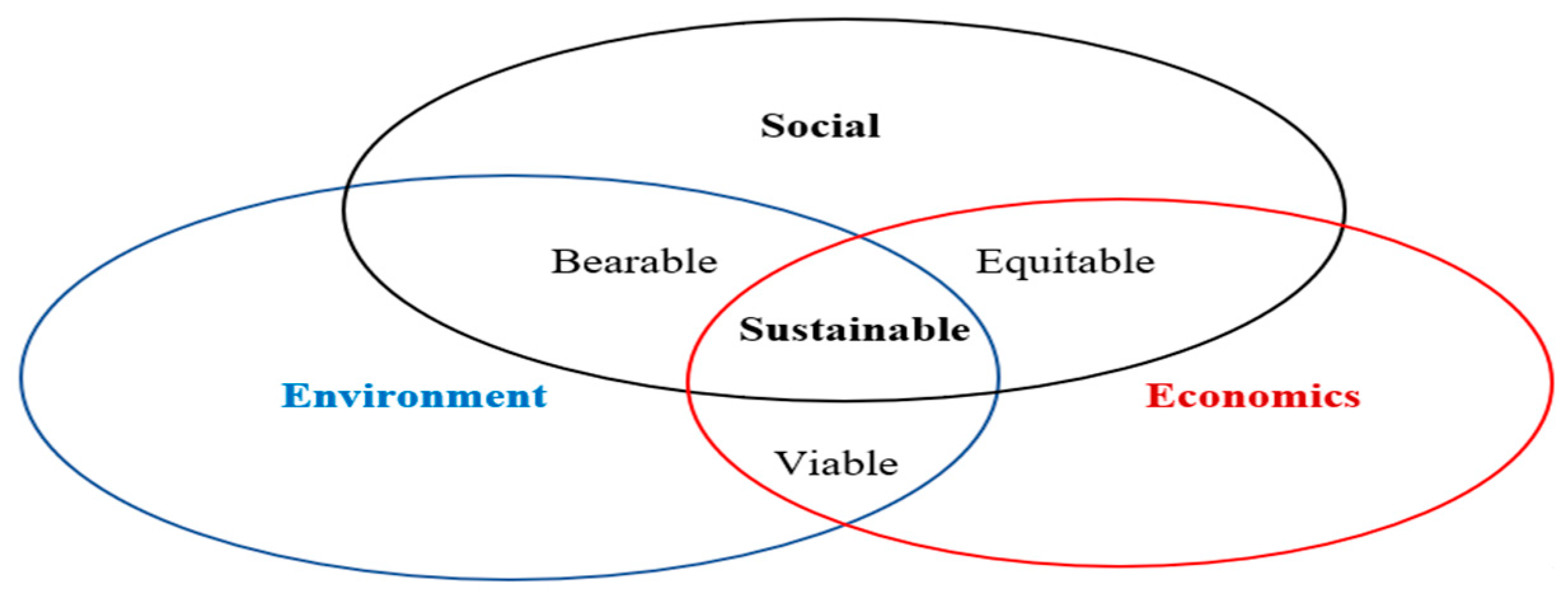
According to [39] sustainable forest management must pay attention to 3 pillars in development, namely economic aspects, social aspects and environmental aspects can be seen in Figure 5, where sustainable forest management does not only pay attention to the current generation but also needs to pay attention to the carrying capacity of the next generation. which will come.
Starting from the formulation of sustainable protection forest development objectives with social forestry principles, the HMPF management scenario is through forest management engineering and social engineering.
- Forest Engineering
Empirical facts from the research results show that the condition of HMPF management is damaged and there is minimal access by the community and stakeholders so the approach used is to apply forest engineering activities. According to [26,28] that forest engineering aims to provide a new model in forest management so that forest management can assist in meeting the needs of people who live around forest areas and indirectly help improve people's welfare. Therefore, the forest engineering technique used is forest management with an agroforestry pattern. According to [40] that the ultimate goal of agroforestry is to improve the welfare of farmers, especially those living around the forest by increasing the active participation of the community in improving and maintaining the environment. This goal can be achieved by optimizing the positive interaction between the various constituent components (trees, crops, livestock/animals) or the interaction between these components and their environment. There are several advantages of agroforestry compared to other land use systems, namely; a) Productivity. Various research results show that the total product of mixed systems in agroforestry is higher than in monoculture systems (planting of one type of plant). The failure of one component/type of plant in a mixed cropping system can be covered by the success of another component/type of garden, b) Diversity. The combination of more than two components in an agroforestry system produces high diversity, both in terms of products and services. Therefore, from an economic standpoint, it can reduce the risk of losses due to fluctuations in market prices. Meanwhile, from an ecological perspective, you can avoid crop failure if you only plant one type, c) Self-sufficiency. High diversification in agroforestry can meet the basic needs of the community, as well as release dependence on external products. The independence of agroforestry systems does not require a lot of inputs such as fertilizers, and pesticides when compared to monoculture systems, d) Stability. Agroforestry practices have optimal diversity and productivity capable of providing balanced results throughout the cultivation of the land, to ensure the stability and sustainability of farmers' income.
The form of protected forest management involving the community in a participatory manner and by regulations and policies for the management of protected forests by Permenhut P.83/2016 concerning social forestry schemes regarding forms of social forestry programs that are by conditions at the HMPF site level, namely community forestry and community forestry. village with an agroforestry pattern without reducing the ecological function of the forest in sustainable management.
Engineering protected forest management with an agroforestry pattern by taking into account the biophysical conditions of the forest including the level of slope and silviculture, namely the types of plants that suit local conditions. Agroforestry is a dynamic resource management system ecological-based nature by integrating planting trees on agricultural land or planting crops on forest land in a unified landscape. Agroforestry can diversify and conserve land production to increase social, economic and ecological benefits[41]. The cropping system in agroforestry is a form of sustainable land management to increase land productivity by combining agricultural and forestry or livestock crops simultaneously in the same land unit with the application of technology that is appropriate to the local socio-cultural community and is a form of environmental mitigation efforts [42]. Based on research data on good biophysical conditions regarding soil types, slopes, climate and types of local vegetation, agroforestry patterns can be applied to the characteristics of the region
- 2.
- Social Engineering
Based on the social problems above, we need a solution that can synergize between forestry engineering and social engineering to answer existing problems, namely managing forests sustainably and for the welfare of the people who live in and around forests. According to[43] that social engineering is an effort to engineer a social object with careful planning to realize social transformation by the target engineer (engineer). Social engineering in principle seeks to change society in the desired direction or other words, is a planned social change (planned social change). In social engineering, tips and strategies are sought to make social life better. In the context of this research, social engineering is needed as an effort to build awareness and direct discourse in the direction expected by all parties in the development of the HMPF area so that management can run sustainably. The stages of social engineering according to [43]are; 1). Collection of information about the target (community). 2) Build a good relationship with the target or someone important for the success of the activity. The results of the identification were then carried out by a community-based approach. 4) Involvement in activities to increase public knowledge through education, outreach and visits. 5) Group formation. 6) Evaluation of actions (measuring the achievements of partner activities to approach the community). 7) Capacity increase.
- Community Empowerment
Referring to the steps mentioned above and based on the facts on the ground, the majority of people living around the HMPF area have their main livelihood as farmers (83.98%). In terms of human resources, it is also still low, because there are 121 people with primary school education (34.97%), 2 people who have not finished elementary school (0.57%) and have never attended school as many as 85 people (15.20%), 99 junior high schools ( 28.61%), SMA 106 (30.64%) and Bachelor 18 (5.25%), thus community empowerment must be carried out systematically. Based on the results of interviews and data obtained in the field, it is clear that community social forestry groups have been formed in the six villages, so the next step is to increase the group's capacity through empowerment activities. According to [44] that the three stages of the empowerment process are awareness, capacity building and empowerment. Awareness is equivalent to gaining an understanding of social forestry programs. Capacity is equality to become a member of a group and receive training, education, and so on. Empowerment is equality to become administrators, involved in decision-making, planning activities, and implementing activities.
- 2.
- Institutional Strengthening
Institutions are software, rules of the game, exemplary, trust, and the consistency of the policies implemented therein [45]. Institutional activities cannot be seen from an internal perspective only, but also from an external perspective [46]. According to[47] that institutions are one of the aspects that determine the success of forest management within the community. Community institutions are a code of behaviour and relationships that are centred on activities to meet complex special needs in society[48].
5. Conclusions
Damage that occurs in protected forest areas as a result of anthropogenic disturbances is forest encroachment, shifting cultivation, grazing and poaching. The largest land cover change in 2011-2016 was 16.17% as a result of anthropogenic activities in the form of forest encroachment, illegal logging, shifting cultivation and hunting of wild animals. The mitigation strategy in protected forest areas is using forest engineering through agroforestry systems and social engineering through community empowerment activities through training and socialization activities on HMPF area management. The FMU of North Halmahera Regency in planning and managing the HMPF area must be adaptive according to the biophysical conditions of the area. HMPF management needs to involve the community in a participatory manner starting from the planning, implementation, organizing, monitoring and evaluation stages so that the community can have a sense of responsibility and process the management. Law enforcement against perpetrators of forest encroachment and illegal logging, to provide rewards and not spread to other people others to encroach on forests and engage in illegal logging activitiesThis section is not mandatory but can be added to the manuscript if the discussion is unusually long or complex.
Author Contributions
For research Conceptualization, RHP, LR, S, JK; methodology and discussion, JK, RHP; data collection, JK; data analysis, JK, RHP; wrote the original draft, JK; language correction, RHP, LR; review and edit, RHP, S, LR; supervision, RHP, S, LR.
Funding
This research was funded by the Education Fund Management Institute (LPDP), Ministry of Finance, Jakarta, Indonesia
Data Availability Statement
Data supporting the findings of this study are available from the first author upon request.
Acknowledgements
The authors are grateful to the Education Fund Management Institute (LPDP), Ministry of Finance, Jakarta, Indonesia, for funding the research activities. Furthermore, they are thankful to forest farmers and several community leaders at the research locations who have been willing to participate in the field survey activities.
Conflicts of Interest
The author declares no conflict of interest.
Appendix A
Figure A1.
Wallace Zone.
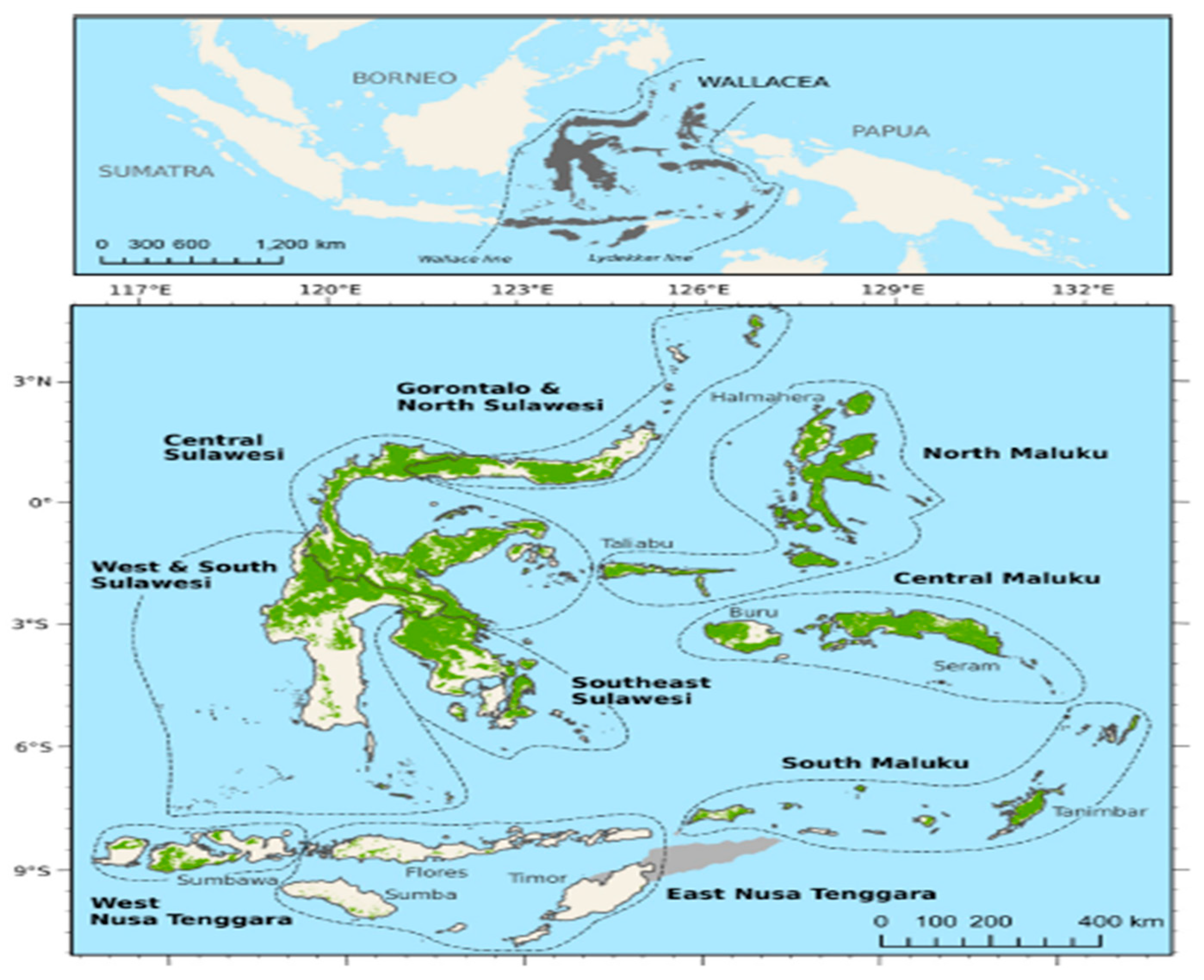
Figure A2.
Villages around the Mount Hamiding Protected Forest area.
References
- Cleary, D.F.R.; DeVantier, L. Indonesia: Threats to the Country’s Biodiversity; 2nd ed.; Elsevier Inc., 2019; ISBN 9780444639523.
- Sutarno. Setyawan AD Biodiversitas Indonesia: Penurunan Dan Upaya Pengelolaan Untuk Menjamin Kemandirian Bangsa. Biodiversitas 2015, 1, 1–13. [Google Scholar] [CrossRef]
- Zhang; Kant, S. ; Liu, J. Principal-Agent Relationships in Rural Governance and Benefit Sharing in Community Forestry: Evidence from a Community Forest Enterprise in China. For. Policy Econ. 2019, 107, 101924. [Google Scholar] [CrossRef]
- Xu, W.; Xiao, Y.; Zhang, J.; Yang, W.; Zhang, L.; Hull, V.; Wang, Z.; Zheng, H.; Liu, J.; Polasky, S.; et al. Strengthening Protected Areas for Biodiversity and Ecosystem Services in China. Proc. Natl. Acad. Sci. U. S. A. 2017, 114, 1601–1606. [Google Scholar] [CrossRef]
- Nugroho, H.Y.S.H.; Nurfatriani, F.; Indrajaya, Y.; Yuwati, T.W.; Ekawati, S.; Salminah, M.; Gunawan, H.; Subarudi, S.; Sallata, M.K.; Allo, M.K.; et al. Mainstreaming Ecosystem Services from Indonesia’s Remaining Forests. Sustain. 2022, 14. [Google Scholar] [CrossRef]
- Hua, F.; Adrian Bruijnzeel, L.; Meli, P.; Martin, P.A.; Zhang, J.; Nakagawa, S.; Miao, X.; Wang, W.; McEvoy, C.; Peña-Arancibia, J.L.; et al. The Biodiversity and Ecosystem Service Contributions and Trade-Offs of Forest Restoration Approaches. Science (80-. ). 2022, 376, 839–844. [Google Scholar] [CrossRef]
- Rudy, R.; Yonariza, Y.; Yanfika, H.; Rahmat, A.; Ramadhani, W.S.; Mutolib, D.A. Forest Cover Change and Legal Pluralism in Forest Management: A Review and Evidence from West Sumatra, Indonesia. Indonesia. J. Sci. Technol. 2021, 6, 299–314. [Google Scholar] [CrossRef]
- Wade, C.M.; Austin, K.G.; Cajka, J.; Lapidus, D.; Everett, K.H.; Galperin, D.; Maynard, R.; Sobel, A. What Are Threatening Forests in Protected Areas? A Global Assessment of Deforestation in Protected Areas, 2001-2018. Forests 2020, 11. [Google Scholar] [CrossRef]
- Waas, R.M.; Riry, W.A. Protection And Utilization Of Protected Forests In Ambon City Environmental Law Perspective. Balobe Law J. 2022, 2, 66. [Google Scholar] [CrossRef]
- Ahmed, H.; Jallat, H.; Hussain, E.; Saqib, N. u.; Saqib, Z.; Khokhar, M.F.; Khan, W.R. Quantitative Assessment of Deforestation and Forest Degradation in Margalla Hills National Park (MHNP): Employing Landsat Data and Socio-Economic Survey. Forests 2023, 14. [Google Scholar] [CrossRef]
- Imai, N.; Furukawa, T.; Tsujino, R.; Kitamura, S.; Yumoto, T. Factors Affecting Forest Area Change in Southeast Asia during 1980-2010. PLoS One 2018, 13, 1–14. [Google Scholar] [CrossRef] [PubMed]
- Chi, Y.; He, C. Impact of Land Use Change on the Spatial and Temporal Evolution of Ecosystem Service Values in South China Karst Areas. 2023.
- Budiprakoso, B.; Ichwandi, I.; Rusdiana, O. Institutional Analysis of Protection Forest Area Land Use Pattern in the North Bandung Area, Bandung Regency. J. Pengelolaan Sumberd. Alam dan Lingkung. (Journal Nat. Resour. Environ. Manag. 2021, 11, 463–475. [Google Scholar] [CrossRef]
- Tacconi, L.; Rodrigues, R.J.; Maryudi, A. Law Enforcement and Deforestation: Lessons for Indonesia from Brazil. For. Policy Econ. 2019, 108, 101943. [Google Scholar] [CrossRef]
- Silva, G.M.; Adami, M.; Galbraith, D.; Nascimento, R.G.M.; Wang, Y.; Shimabukuro, Y.E.; Emmert, F. Spatial Distribution of Secondary Forests by Age Group and Biomass Accumulation in the Brazilian Amazon. 2023.
- Voigt, M.; Supriatna, J.; Deere, N.J.; Kastanya, A.; Mitchell, S.L.; Rosa, I.M.D.; Santika, T.; Siregar, R.; Tasirin, J.S.; Widyanto, A.; et al. Emerging Threats from Deforestation and Forest Fragmentation in the Wallacea Centre of Endemism. Environ. Res. Lett. 2021, 16. [Google Scholar] [CrossRef]
- Rofita; Utami, S. N.H.; Maas, A.; Nurudin, M. Spatial Distribution of Soil Morphology and Physicochemical Properties to Assess Land Degradation under Different NDVI and TRI in North Halmahera, Indonesia. J. Degrad. Min. Lands Manag. 2021, 9, 3137–3154. [Google Scholar] [CrossRef]
- Buruso, F.H.; Adimassu, Z.; Sibali, L.L. Effects of Land Use/Land Cover Changes on Soil Properties in Rib Watershed, Ethiopia. Catena 2023, 224, 106977. [Google Scholar] [CrossRef]
- Wahyu, E. Peluang Dan Tantangan Dalam Pengembangan Silvofishery Di Pulau Lombok. Seminar Nasional Agroforestri III.; 2012.
- Apriyanti, D.; Faqih, R.; Purnawan, B. Pembuatan Peta Penutup Lahan Menggunakan Klasifikasi Terbimbing Metode Maximum Likelilhood Pada Citra Landsat 8 ( Studi Kasus : Kabupaten Indramayu, Provinsi Jawa Barat ) Making Land Cover Map Using Supervised Classification Maximum Likelihood Method In. Semin. Nasioanl Penginderaan Jauh 2017, 8, 225–235. [Google Scholar]
- Li, X.; Hai, Q.; Zhu, Z.; Zhang, D.; Shao, Y.; Zhao, Y. Spatial and Temporal Changes in Vegetation Cover in the Three North Protection Forest Project Area Supported by GEE Cloud Platform. 2023.
- Fisher, R. Tropical Forest Monitoring, Combining Satellite and Social Data, to Inform Management and Livelihood Implications: Case Studies from Indonesian West Timor. Int. J. Appl. Earth Obs. Geoinf. 2012, 16, 77–84. [Google Scholar] [CrossRef]
- Haq Shiek Marifatul, S.; Soares, E.; Rashid, I.; Khuroo, A.A. Trees, Forests and People Human-Driven Disturbances Change the Vegetation Characteristics of Temperate Forest Stands : A Case Study from Pir Panchal Mountain Range in Kashmir Himalaya ☆. Trees, For. People 2021, 6, 100134. [Google Scholar] [CrossRef]
- Salomon, W.; Sikuzani, Y.U.; Kouakou, A.T.M.; Barima, S.S.; Theodat, J.M.; Bogaert, J. Monitoring of Anthropogenic Effects on Forest Ecosystems within the Municipality of Vallières in the Republic of Haiti from 1984 to 2019. Trees, For. People 2021, 6, 100135. [Google Scholar] [CrossRef]
- Alfany Zelly, Markum, B.S. The Analysis of Factors That Cause The Encroachment Forest in The Production Forest Area Sub-. 2017.
- Fazriyas, F.; Tamin, R.P.; Irawan, D. Faktor Yang Berhubungan Dengan Perambahan Kawasan Hutan Lindung Gambut (Studi Kasus Desa Bram Itam Kanan Kecamatan Bram Itam Kabupaten Tanjung …. J. Silva Trop. 2018, 2, 6–10. [Google Scholar]
- Simanjuntak Radios, Sulistiyowati Eny, M.E. Pertanian Pala Sebagai Alternatif Mata Pencaharian Bagi Perambah Hutan Di Desa Wangongira Dan Di Desa Wateto, Kabupaten Halmahera Utara. ejournal.unkhair.ac.id 2018, 74–83.
- Watimena, G. Indigenous Knowledge. In Proceedings of the Proceeding; 2011; pp. 343–368. [Google Scholar]
- Santoro, A.; Piras, F. Natural Forests or Cultural Forests ? Forest Changes within Italian Protected Areas in the Last 85 Years. 2023. [Google Scholar]
- Bentsi-Enchill, F.; Damptey, F.G.; Pappoe, A.N.M.; Ekumah, B.; Akotoye, H.K. Impact of Anthropogenic Disturbance on Tree Species Diversity, Vegetation Structure and Carbon Storage Potential in an Upland Evergreen Forest of Ghana, West Africa. Trees, For. People 2022, 8, 100238. [Google Scholar] [CrossRef]
- Ulja, F.; Hermansyah, A. Penanggulangan Tindak Pidana Illegal Logging Di Kawasan Hutan Lindung Beutong. 2020, 4, 503–511. [Google Scholar]
- Kurniadi, R.; Purnomo, H.; Wijayanto, N.; Fuah, A.M. Model Pengelolaan Ternak Di Sekitar Hutan Gunung Mutis Dan Dampaknya Terhadap Kelestarian Hutan. J. Ilmu Kehutan. 2017, 11, 156. [Google Scholar] [CrossRef]
- Wang, Y.; Ziv, G.; Adami, M.; Almeida, C.A. de; Antunes, J.F.G.; Coutinho, A.C.; Esquerdo, J.C.D.M.; Gomes, A.R.; Galbraith, D. Upturn in Secondary Forest Clearing Buffers Primary Forest Loss in the Brazilian Amazon. Nat. Sustain. 2020, 3, 290–295. [Google Scholar] [CrossRef]
- Chazdon, R.L.; Broadbent, E.N.; Rozendaal, D.M.A.; Bongers, F.; Zambrano, A.M.A.; Aide, T.M.; Balvanera, P.; Becknell, J.M.; Boukili, V.; Brancalion, P.H.S.; et al. Carbon Sequestration Potential of Second-Growth Forest Regeneration in the Latin American Tropics. Sci. Adv. 2016, 2. [Google Scholar] [CrossRef]
- Molins, J. Masyarakat Hutan Dan Global Harus Bersatu Dalam Menangani Risiko Perburuan Satwa Liar. 2021. [Google Scholar]
- Dako, F.X. Pengelolaan Hutan Lindung Mutistimau Dengan Prinsip Kehutanan Social, UGM, Yogyakarta, 2020.
- Putraditama, A.; Kim, Y.S.; Sánchez Meador, A.J. Community Forest Management and Forest Cover Change in Lampung, Indonesia. For. Policy Econ. 2019, 106, 101976. [Google Scholar] [CrossRef]
- Lin, C.; Doyog, N.D. Challenges of Retrieving LULC Information in Rural-Forest Mosaic Landscapes Using Random Forest Technique. Forests 2023, 14, 1–18. [Google Scholar] [CrossRef]
- Annika, K.; Mikko, K.; Teppo, H.; Kyle, E.; Jyrki, K. Decision Support for Forest Management; Gadow, K. Von, Georg-August, Pukkala, T., Tome, M., Eds.; 2nd ed.; Springer: New York, 2015; ISBN 978-3-319-23521-9. [Google Scholar]
- Suryani, E.; Dariah, A. Peningkatan Produktivitas Tanah Melalui Sistem Agroforestri. J. Sumberd. Lahan 2012, 101–109. [Google Scholar]
- Rohandi, A. Karakteristik Agroekologi Dan Daya Aaptasi Tanaman Garut (Maranta Arundinaceae L) Pada Sistem Agroforestri Di Kabupaten Garut, UNversitas Gadjah Mada, 2018.
- Chavan, S.B.; Dhillon, R.S.; Sirohi, C.; Uthappa, A.R.; Jinger, D.; Jatav, H.S.; Chichaghare, A.R.; Kakade, V.; Paramesh, V.; Kumari, S.; et al. Carbon Sequestration Potential of Commercial Agroforestry Systems in Indo-Gangetic Plains of India: Poplar and Eucalyptus-Based Agroforestry Systems. Forests 2023, 14, 559. [Google Scholar] [CrossRef]
- Alimah Siti, Mudjiono, Susiati Heni, Hastuti Ristianan Dwi, Irawan Dimas, N. A. Jurnal Pengembangan Energi Nuklir Informasi Artikel Abstrak. J. Pengemb. Energi Nukl. 2019, 21, 63–70. [Google Scholar]
- Sanudin, S.A.A. Evaluasi Kehutanan Social: Tantangan Generasi 3, 2019.
- Sari, Novita, G. ; Toknok, B. Kelembagaan Kelompok Tani Hutan Program Pendampingan Scbfwm Disekitar Sub Daerah Aliran Sungai Miu ( Kasus Desa Pakuli Kecamatan Gumbasa Kabupaten Sigi ). War. Rimba 2013, 1, 1–8. [Google Scholar]
- Kusnandar, K.; Padmaningrum, D.; Rahayu, W.; Wibowo, A. Rancang Bangun Model Kelembagaan Agribisnis Padi Organik Dalam Mendukung Ketahanan Pangan. J. Ekon. Palembang. Kaji. Masal. Ekon. dan Pembang. 2013, 14, 92. [Google Scholar] [CrossRef]
- Hamzah, H.; Suharjito, D.; Istomo, I. Efektifitas Kelembagaan Lokal Dalam Pengelolaan Sumber Daya Hutan Pada Masyarakat Nagari Simanau, Kabupaten Solok. Rizal. Kebijak. Pertan. Dan Lingkung. Rumusan Kaji. Strategy. Bid. Pertan. dan Lingkung. 2016, 2, 116. [Google Scholar] [CrossRef]
- Awang, S.A.; Budi, W.E.; Suryanto, S. Unit Manajement Hutan Rakyat; Proses Konstruksi Pengetahuan, Lokal, Firman, F., Noor, R.Z., Eds.; Pertama.; Banyumili Art Network: Yogyakarta, 2007; ISBN 978-979-16380-0-5. [Google Scholar]
Figure 2.
Data processing flowchart.
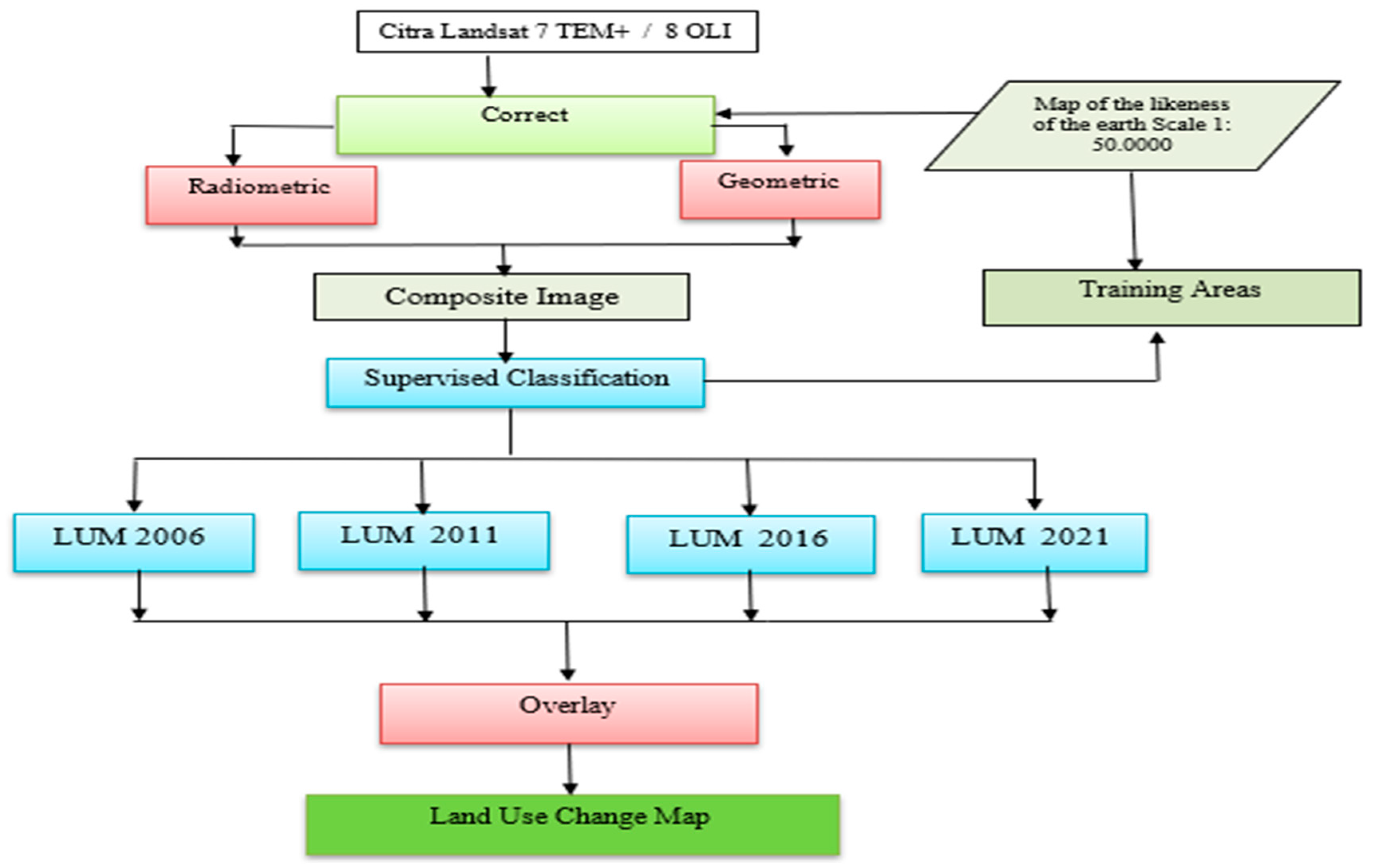
Figure 5.
Three Pillars of Sustainable Forest Management. Source: According to [12].
Figure 5.
Three Pillars of Sustainable Forest Management. Source: According to [12].
Disclaimer/Publisher’s Note: The statements, opinions and data contained in all publications are solely those of the individual author(s) and contributor(s) and not of MDPI and/or the editor(s). MDPI and/or the editor(s) disclaim responsibility for any injury to people or property resulting from any ideas, methods, instructions or products referred to in the content. |
© 2024 by the authors. Licensee MDPI, Basel, Switzerland. This article is an open access article distributed under the terms and conditions of the Creative Commons Attribution (CC BY) license (https://creativecommons.org/licenses/by/4.0/).
Copyright: This open access article is published under a Creative Commons CC BY 4.0 license, which permit the free download, distribution, and reuse, provided that the author and preprint are cited in any reuse.


