
Submitted:
29 October 2024
Posted:
30 October 2024
You are already at the latest version
Abstract
Lomami National Park, located in the Democratic Republic of Congo, is renowned for the integrity of its forest ecosystems, safeguarded by the absence of agricultural activities and limited road access. However, these ecosystems remain under-researched, particularly regarding forest cover dynamics. This research gap poses a significant challenge to establishing rigorous monitoring, which is essential for ensuring the long-term preservation of these valuable ecosystems. This study evaluates land cover dynamics within Lomami National Park through supervised classification of Landsat images from 2008, 2016, and 2024. Seven spatial structure indices were calculated to highlight the dynamics of landscape composition and configuration, distinguishing between the park's core and buffer zones. The underlying spatial transformation processes were identified using a decision tree approach. The results highlight a striking contrast in forest cover stability between Lomami National Park and its surrounding periphery. Within the park, forest cover has not only been preserved but has also shown a modest increase, rising from 92.60% to 92.75%. In contrast, the peripheral zone experienced a significant decline in forest cover, decreasing from 79.32% to 70.48% over the same period. This stability within the park goes beyond simply maintaining forested areas; it includes the preservation and strengthening of the spatial structure of forest ecosystems. For instance, edge density, which is a key indicator of forest edge compactness, remained stable in the park, fluctuating between 8 m/ha and 9 m/ha. However, in the peripheral zone, edge density exceeded 35 m/ha, suggesting that forest edges in the park are considerably more cohesive and intact than in the surrounding areas. Furthermore, the spatial transformation processes within each area underscore these contrasting dynamics. In the park, the main process was aggregation of primary forest patches, which reflects a trend toward continuous and connected forest landscapes. By contrast, the peripheral zone experienced dissection, indicating fragmentation and breakdown of forest patches. Together, these findings underscore the park's role in maintaining both the extent and the structural integrity of forest ecosystems, setting it apart from the more degraded periphery. These findings highlight not only the resilience of forest ecosystems in the face of limited anthropogenic pressures but also the crucial importance of effective land management and rigorous conservation strategies in addressing the challenges of urbanization and surrounding rural expansion. They further emphasize that well-adapted conservation measures, combined with specific demographic and socio-economic conditions, can play a pivotal role in long-term forest preservation and ecological stability.
Keywords:
Primary forest
; Spatial structure
; Ecosystem conservation
; Remote sensing/GIS
; Ecological resilience
; Land-use planning
; Protected area
1. Introduction
Tropical forests are globally recognized as the principal reservoirs of terrestrial biodiversity, both in terms of species diversity and ecosystem variety [1]. They play a crucial role in climate regulation at both local and global scales [2]. By slowing runoff and mitigating soil erosion, these forests help reduce the destructive impact of torrential rains [2,3]. Additionally, they store substantial amounts of carbon (247 gigatons) while generating a significant portion of the world's annual oxygen (20% to 30%) [4,5]. In Central Africa, these ecosystems provide livelihoods for nearly 60 million people who live near or depend on these forests [6−8].
Despite their critical importance, tropical forests are under unsustainable pressures. Deforestation and degradation, driven by excessive logging, agricultural expansion, and mining activities, threaten these ecosystems at an alarming rate. Africa loses approximately 3.9 million hectares of forest annually, endangering the unique biodiversity and ecosystem services provided by these regions [6,7,9−11]. Unlike other tropical regions where deforestation is often driven by large-scale exploitation projects, in Central Africa, it is primarily caused by small-scale activities such as subsistence agriculture, charcoal production, and fuelwood collection, leading to the loss of nearly 18 million hectares of forest since 2000 [7]. While these practices are driven by immediate economic needs, they compromise resource sustainability and increase the vulnerability of ecosystems to degradation.
In response to these challenges, several Central African states have implemented policies to increase the proportion and extent of their forest cover. The Democratic Republic of the Congo (DRC) launched an ambitious conservation policy with the goal of protecting 17% of its territory through the establishment of protected areas [12]. This initiative led to the creation of the Lomami National Park in 2016, covering an impressive area of 88,879 km², complemented by a buffer zone of 22,000 km² [13]. This park consists primarily of lowland tropical moist forests, with emergent islands of edaphic and hydromorphic savannah in its southern part. Located in a region characterized by extremely low population density, this protected area is known for the integrity of its relatively undisturbed forest ecosystems, due to the absence of significant agricultural activities, logging, and road inaccessibility [13,14]. However, this assertion is not supported by empirical data. Despite their reputation, these ecosystems remain largely understudied, particularly regarding forest cover dynamics. No detailed studies have yet been conducted to illuminate this essential dimension of forest ecosystem health and resilience.
The lack of quantifiable data on forest dynamics limits our ability to accurately assess the effectiveness of conservation measures, hinders the evaluation of ecosystem services provided by these forests, and complicates the justification for conservation investments. This situation also restricts access to available funding and the mobilization of initiatives in favor of the park by organizations and policymakers [15]. Furthermore, this data insufficiency makes it difficult to identify threats early, hinders the optimal implementation of preventive measures, and may result in delayed detection of changes, making corrective interventions more challenging and costly [16]. Finally, it leads to inefficient allocation of available resources and the implementation of inadequate plans, thus compromising the ability of managers to make informed decisions based on accurate and up-to-date data [17 ,18].
The spatial and temporal dynamics of primary forest ecosystems within parks in Africa, particularly in Gabon and Cameroon, are well-documented. Studies highlight the complexity and stability of these ecosystems in the face of natural and anthropogenic disturbances. However, gaps remain in understanding the specific dynamics of less studied or newly established parks, such as the Lomami National Park. The rationale for conducting a study on deforestation in Lomami National Park lies in the observed research gap in existing literature. Previous studies have primarily quantified deforestation at the provincial level [19], while investigations focused on Lomami National Park since its establishment have predominantly centered on characterizing its fauna [20−23] or composition, structure, and the sustainability of use of its forests by local communities in buffer zones [24]. The absence of detailed quantitative data on forest dynamics in parks like Lomami restricts our ability to effectively assess the impacts of conservation measures and potential threats. Studying and quantifying the forest dynamics of the Lomami National Park will fill this gap by providing essential data on spatial and temporal changes in an unexplored context. Consequently, these studies have largely overlooked the critical analysis of the spatiotemporal dynamics of habitats within the park. By addressing this oversight, the current study aims to provide a comprehensive understanding of deforestation trends and their implications for habitat integrity, thereby contributing to more effective conservation strategies within this vital ecological zone.
Furthermore, it is also recognized that even ecosystems considered intact can undergo subtle modifications and long-term changes [25]. Monitoring these evolutions is crucial for ensuring biodiversity preservation, assessing human impact, and identifying potential threats before they become critical [26]. To meet these needs, various complementary approaches to data acquisition and analysis, such as remote sensing and landscape ecology, are employed. Remote sensing, particularly through satellite imagery, provides valuable data on the extent of forest habitats, deforestation, and habitat fragmentation, enabling the assessment of human activities and the detection of environmental trends on a large scale [27−29]. Landscape ecology analyzes the spatial structure of landscapes to understand how it influences biodiversity and population dynamics [30,31]. The combination of these approaches, less time-consuming and resource-intensive than traditional methods such as forest inventories, weather stations, and environmental sensors, proves particularly effective for monitoring the health of forest ecosystems within protected areas [32,28,33]. It allows for the design of integrated management strategies aimed at ensuring the long-term preservation of forest biodiversity [34−36].
This study aims to fill this significant gap in understanding the evolution of forest cover in the Lomami National Park and its periphery by conducting a thorough spatial analysis of the dynamics of these forest ecosystems between 2008 and 2024. We hypothesize that due to low population density, geographic isolation, and the absence of significant agricultural activities and logging, the forest ecosystems of the Lomami National Park remain relatively undisturbed, with few significant changes over time.
2. Materials and Methods
2.1. Study area
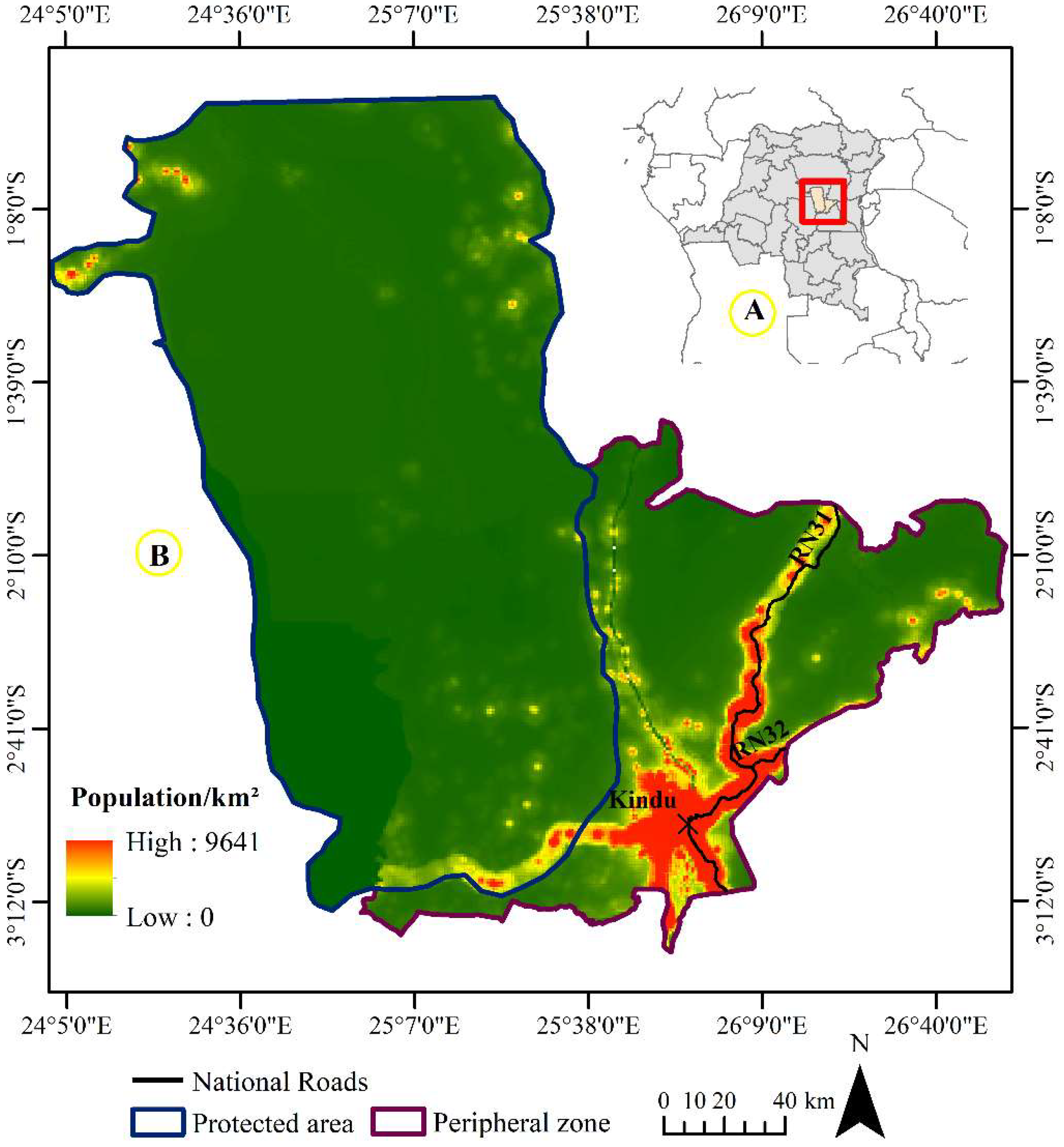
The study area encompasses the Lomami National Park and its periphery (figure 1). Located approximately at 2° 32′ 42″ S and 25° 42′ 20″ E, Lomami National Park spans across the Maniema and Tshopo provinces, covering an area of 8,879 km². It is surrounded by a buffer zone of 22,000 km². The park is predominantly covered by lowland equatorial rainforest, with hydromorphic savannas localized in its southern part. This forest is rich in floristic biodiversity, hosting species such as Milicia excelsa (Welw.) C.C. Berg, Gilbertiodendron dewevrei (Linnaeus), Entandrophragma spp., Pycnanthus angolensis (Linnaeus), and Musanga cecropioides (R.Br. ex Tedlie) [13,37]. Despite this diversity, the region remains one of the least botanically explored areas in tropical Africa [38,39]. Since 2007, research conducted by the Lukuru Foundation under the TL2 project has revealed notable faunal richness, including 59 species of large mammals and 240 species of birds. A significant discovery was the Cercopithecus lomamiensis [40], a newly identified primate species endemic to the forests between the Tshuapa and Lomami rivers [40]. The region's climate is equatorial, with an average annual rainfall of 1,600 mm and monthly temperatures ranging between 23°C and 26°C. The short dry season occurs from June to July [24]. The soils are ferralitic, composed of sand and clay [37]. Approximately a hundred small hamlets border the park, where local communities primarily engage in subsistence agriculture, hunting, and fishing, mainly within the park’s buffer zone [37].
Figure 1.
Geographical location of the Lomami National Park (protected area). The park is in the Maniema and Tshopo provinces, in DRC (A). The park covers a total area of 30,000 km² and is attached to a densely populated peripheral zone, including the city of Kindu (B).
Figure 1.
Geographical location of the Lomami National Park (protected area). The park is in the Maniema and Tshopo provinces, in DRC (A). The park covers a total area of 30,000 km² and is attached to a densely populated peripheral zone, including the city of Kindu (B).
2.2. Data
The landscape under study was derived from three satellite images obtained via the geospatial analysis platform Google Earth Engine (GEE), sourced from the USGS/Google site. These images were acquired using Landsat sensors, specifically from 2008 (Enhanced Thematic Mapper Plus sensor), 2016, and 2024 (Operational Land Imager sensor), all with a spatial resolution of 30 meters. The choice of these sensors was based on the availability of the images. The images were acquired during the dry season (June-July) to ensure consistency in the spectral response of different vegetation covers [41,42]. These images span three distinct periods: (a) before the park's establishment, (b) during the park's creation, and (c) after the park's creation. This temporal selection allows for a comparison of conditions before and after the establishment of the Lomami National Park. The only preprocessing applied involved the use of the FilterMetadata ('CLOUD_COVER', ‘less_than’ 20) filter, based on the image metadata. This filter selects images with cloud cover less than 20% [43], thereby reducing cloud-affected images, which improves the reliability of the results and the understanding of observed surface variations [44]. For the analysis, Google Earth Engine was utilized for Landsat image preprocessing and land cover classification. Additionally, ArcGIS Pro 3.3 software was used for map layout design.
2.3. Landsat images’ classification
Using the preprocessed data, a false-color composite of the Landsat images was created by combining the near-infrared, red, and green bands. The near-infrared and red bands allow optimal discrimination of vegetation, while the green band enhances image contrast by adding extra details, facilitating the detection of non-vegetated areas [45,46]. Using a GARMIN 64S GPS device (accuracy ±3 m), 500 training zones representing various land cover classes of the Lomami National Park and its peripheral zone were collected. These zones included forests, savannas, water bodies, as well as urbanized and agricultural areas. The data collection was carried out during a field mission in the park in October 2023. Subsequently, these data were merged into a single, unified collection.
These zones were used to create a model for training the Random Forest algorithm, which employs an ensemble approach based on multiple decision trees. This method enhances classification accuracy by reducing errors and providing more reliable predictions [47,48]. Four land cover classes were defined: forest areas, savanna, water, and urbanization and agriculture complex (Table 1).
To assess classification accuracy, we followed the best practices recommended by Olofsson et al. [49], using unbiased area estimators and estimating uncertainty with reference observations obtained from change maps for the periods 2008-2016 and 2016-2024. Samples were stratified according to stable classes and changes for each period, with sample sizes determined using Cochran's method [50]. These land cover classes included: Forest, Urbanization and agricultural Complex, Water, Savanna, Forest Gain, Urbanization and agricultural Complex Gain, Water Gain, and Savanna Loss. A total of 1040 points were sampled over the two periods, with proportions distributed according to stratum size. Error matrices, indicating estimated area proportions and confirmed values, were generated using QGIS version 3.26.1 (developed by the global QGIS community, Buenos Aires, Argentina), providing accuracy measures such as overall accuracy, user's accuracy, and producer's accuracy.
2.4. Assessment of landscape dynamics
To analyze the relationships between landscape configuration and ecological processes, it is crucial to quantify landscape structures using metrics [51,52]. Since landscape measurements often exhibit high correlations [53,54], it is important to select diverse metrics to avoid redundancy and achieve a more accurate assessment. Therefore, six metrics were calculated for Lomami National Park and its periphery, enabling a detailed analysis of anthropization levels and the underlying ecological processes (Table 2).
A deforestation rate, derived from changes in the forest class area, provided information on the intensity of human impacts on forest ecosystems. It was determined using the equation proposed by [63]. The use of the "Landscapemetrics" package in R (version 4.2.3) enabled the quantification of these aspects [64 ,65]. Additionally, the decision tree algorithm developed by Bogaert et al. [66], which involves comparing the PN, CA, and total perimeter of land use patches, was applied to identify spatial transformation processes in a landscape between two specific dates. A decrease in the PN and CA indicates patches attrition, while an increase in CA suggests aggregation. If the CA increases while the PN remains constant, this indicates enlargement. A simultaneous increase in both CA and the PN signals the creation of new patches, whereas a decrease in CA with an increase in the PN indicates dissection. Fragmentation is characterized by an increase in the PN and a significant loss of CA. To distinguish between fragmentation and dissection, a ratio of total areas between different times is used, with a ratio greater than 0.75 indicating dissection and a ratio of 0.75 or less suggesting fragmentation [67]. A decrease in total area may result in perforation if the total perimeter increases, or a reduction in patch size if the perimeter remains constant. If the number of patches and total area are stable, a constant total perimeter suggests displacement, while a variable perimeter indicates deformation.
3. Results
3.1. Classification and mapping
Table 3 provides a summary of the accuracy results for the supervised classifications of Landsat 7, 8, and 9 images, obtained using the Random Forest classifier for the periods from 2008 to 2024. The classifications exhibited an overall accuracy exceeding 80% for each analyzed period, demonstrating remarkable reliability in differentiating various land cover types. User and producer accuracy values, ranging from 82% to 89%, further attest to the high quality of the results. Additionally, the 95% confidence interval for the stratified area estimates of each land cover class remains below 5% for all studied periods, reinforcing the robustness of the conclusions drawn from this analysis.
The visual analysis of land cover maps for Lomami National Park and its peripheral zone reveals, on one hand, relative stability in the spatial structure of the protected landscape, and on the other hand, notable transformations in the peripheral zone (Figure 2). Indeed, the stability observed in the protected area is reflected by the absence of significant and perceptible dynamics within different land use classes between the periods 2008-2016 and 2016-2024. In contrast, the peripheral zone shows centrifugal spatial changes, marked by a regression in forest cover, replaced by rural complexes, mainly around settlements along the Congo River and its tributaries.
3.2. Dynamics of land cover composition in Lomami National Park and its periphery between 2008 and 2024
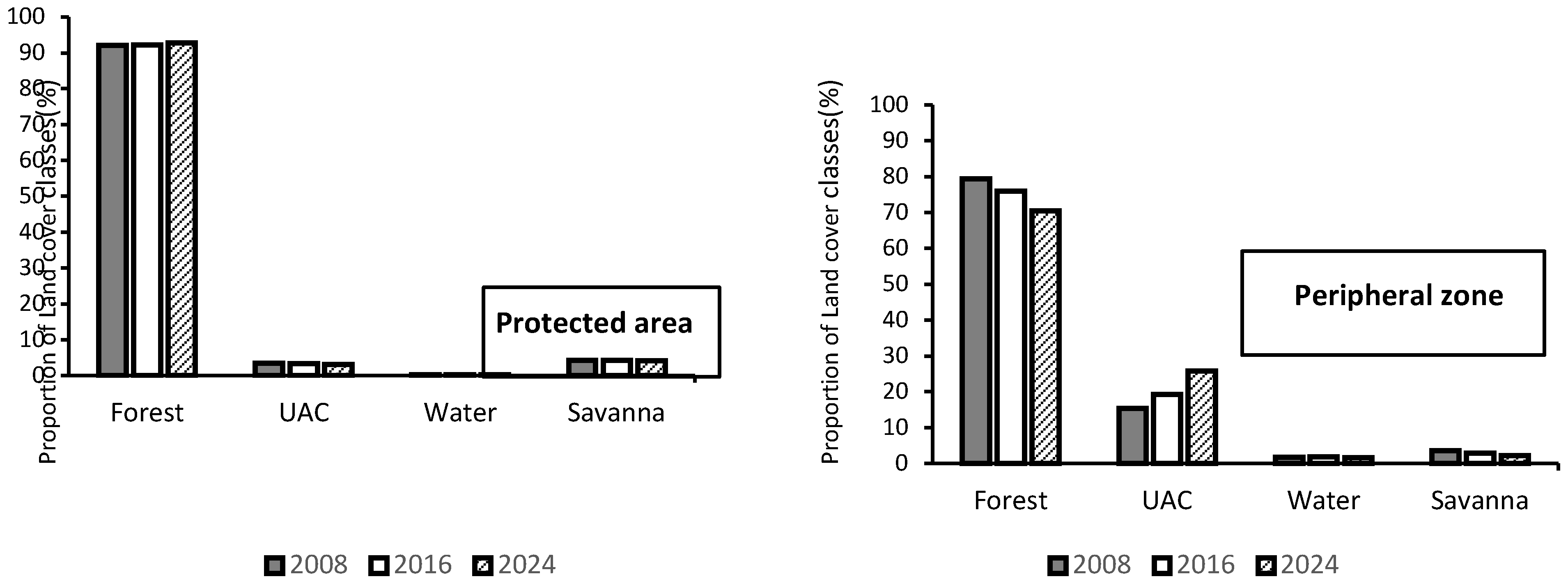
The evolution of land cover in Lomami National Park reveals a general trend towards landscape stability, with a slight increase in forest cover observed between 2008 and 2024 (figure 3). In contrast, the adjacent peripheral zone has experienced a relative regressive dynamic in its forest ecosystems. In 2008, forests covered 92.06% and 79.32% of the areas in the protected zone and the peripheral zone, respectively. By 2016, these proportions had changed, reaching 92.24% for the protected zone, while the peripheral zone saw a decrease to 75.91%. This trend continued until 2024, with forest cover reaching 92.75% in the protected zone, while it reduced to 70.48% in the peripheral zone.
Meanwhile, the water class area showed a slight increase, from 0.25% to 0.27% in the protected zone and from 1.71% to 1.85% in the peripheral zone between 2008 and 2016. Conversely, savannas experienced a slight regression, with their area decreasing from 4.29% to 4.21% in the protected zone and from 3.60% to 2.97% in the peripheral zone. The urbanization and agriculture complex exhibited varied dynamics: a decrease in the protected zone, from 3.40% to 3.28%, while in the peripheral zone, it increased from 15.36% to 19.27% between 2008 and 2016. By 2024, the urbanization and agriculture complex in the protected zone had dropped to 3.10%, while it significantly increased in the peripheral zone, reaching 25.73%.
There is a general trend towards an increase in forest cover in the protected zone at the expense of savannas and rural complexes. The relative stability of water bodies and the relative increase in urbanization and agriculture complex, particularly in the peripheral zone, suggest that human activities are more pronounced at the park’s periphery. However, with an annual deforestation rate of 0.03%, significantly lower than the national average of 0.40%, these dynamics highlight the effectiveness of conservation efforts within the park while also underscoring the need for continuous monitoring and management, especially in areas where anthropogenic pressures are increasing.
Figure 3.
Evolution of the total area of land cover classes in the Lomami National Park and its periphery zone 2008 and 2024. The total areas are 30,685.2 km² for the protected zone and 12,686.05 km² for the periphery.
Figure 3.
Evolution of the total area of land cover classes in the Lomami National Park and its periphery zone 2008 and 2024. The total areas are 30,685.2 km² for the protected zone and 12,686.05 km² for the periphery.
Additionally, the transition matrices presented in Table 4 show a notable consistency in the landscape matrix with few significant conversions between land cover classes for the protected area. In contrast, relatively significant conversions were observed in the periphery zone adjacent to the park.
Between 2008 and 2016, only 1.97% of forests in the protected area and 6.13% of those in the periphery zone were converted to other land cover types. Conversely, 2.15% and 2.73% of areas occupied by rural complexes, water bodies, and savannas were reconverted to forests. The main changes include the conversion of 2.08% of rural complexes to forests and 1.80% of forests to rural complexes in the protected area, as well as 5.86% of forests converted to rural complexes in the adjacent zone of the park.
Between 2016 and 2024, 1.56% of forests in the protected area and 8.24% in the buffer zone were converted to other land cover classes, while 1.77% and 2.81% of areas occupied by rural complexes, water bodies, and savannas were reconverted to forests. Land cover changes were minimal, with low forest losses and gains between 2008-2016 and 2016-2024 in the protected area. In contrast, forests experienced notable conversions in the periphery zone adjacent to Lomami National Park.

Table 4.
Transition matrix of land cover classes in Lomami National Park and its peripheral zone between 2008-2016 and 2016-2024. Rows represent the proportions of land cover classes at the initial date, columns at the final date, and the bold values indicate the proportions that remained stable. The values in the table are expressed as percentages (%) of the total area of the protected zone (30,685.20 km²) and the peripheral zone (12,686.05 km²). UAC: urbanization and agriculture complex.
| Protected area | |||||
|---|---|---|---|---|---|
| UAC | Forest | Water | Savanna | Total 2008 | |
| UAC | 1.29 | 2.08 | 0.00 | 0.03 | 3.40 |
| Forest | 1.80 | 90.09 | 0.02 | 0.15 | 92.06 |
| Water | 0.00 | 0.00 | 0.25 | 0 | 0.25 |
| Savanna | 0.19 | 0.07 | 0 | 4.03 | 4.29 |
| Total 2016 | 3.28 | 92.24 | 0.27 | 4.21 | |
| UAC | Forest | Water | Savanna | Total 2016 | |
| UAC | 1.56 | 1.46 | 00.0 | 0.26 | 3.28 |
| Forest | 1.48 | 90.68 | 0.01 | 0.07 | 92.24 |
| Water | 0.00 | 0.03 | 0.24 | 00.0 | 0.27 |
| Savanna | 0.06 | 0.28 | 0.00 | 3.87 | 4.21 |
| Total 2024 | 3.10 | 92.45 | 0.25 | 4.20 | |
| Periphery | |||||
| UAC | Forest | Water | Savanna | Total2008 | |
| UAC | 12.81 | 2.44 | 0.06 | 0.05 | 15.36 |
| Forest | 5.86 | 73.18 | 0.08 | 0.19 | 79.32 |
| Water | 0.01 | 0.01 | 1.70 | 00.0 | 1.71 |
| Savanna | 0.59 | 0.28 | 0.01 | 2.72 | 3.6 |
| Total 2016 | 19.27 | 75.91 | 1.85 | 2.97 | |
| UAC | Forest | Water | Savanna | Total2016 | |
| UAC | 17.04 | 2.02 | 0.01 | 0.20 | 19.27 |
| Forest | 7.97 | 67.67 | 0.01 | 0.26 | 75.91 |
| Water | 0.12 | 0.11 | 1.59 | 0.03 | 1.85 |
| Savanna | 0.6 | 0.68 | 0.01 | 1.67 | 2.96 |
| Total 2024 | 25.73 | 70.48 | 1.62 | 2.16 | |
The Landscape Disturbance Index serves as an essential tool for assessing landscape anthropization, providing quantitative information on the changes observed between 2008 and 2024 in the study areas. In this study, the index values revealed a general trend towards low values (Figure 4), indicating a predominance of natural land cover classes. However, an increasing trend was noted in the peripheral zone adjacent to the park. In 2008, the index was 0.08 and 0.23 for the protected and peripheral zones, respectively, and 0.08 and 0.23 in 2016 for both zones, subsequently 0.75 and 0.38 in 2024 for both zones. These values suggest both minimal landscape alteration in the protected zone and a growing increase in anthropization in the peripheral zone adjacent to the park. This observation underscores the importance of effective conservation measures to maintain ecosystem integrity in urban areas and highlights the negative impact of anthropogenic activities on the sustainability of natural resources and habitats for local wildlife.
The Landscape Disturbance Index serves as a critical tool for assessing landscape anthropization, providing quantitative insights into changes observed between 2008 and 2024 within the study zones. In this study, the index values revealed a general trend towards low values (Figure 3), indicating a predominance of natural land classes throughout the study period. In 2008, the index was 0.04, suggesting minimal landscape alteration due to human activities in the surveyed park zones. This value slightly increased to 0.09 by 2016, possibly indicating a marginal rise in anthropization. Importantly, this value remained constant at 0.09 in 2024 for both park zones studied, indicating stability in the observed level of anthropization. The consistent index values between 2016 and 2024 highlight stability in the prevalence of natural landscape features studied, despite an initial slight increase. This observation underscores the importance of effective conservation measures to maintain ecosystem integrity in urban areas, ensuring sustainability of natural resources and habitats for local wildlife.
Figure 4.
Evolution of the anthropization index in the Lomami National Park and its peripheral zone between 2008 and 2024.
Figure 4.
Evolution of the anthropization index in the Lomami National Park and its peripheral zone between 2008 and 2024.
3.3. Dynamics of forest configuration in Lomami National Park and its periphery between 2008 and 2024
In the protected area, the Largest Patch Index (LPI) shows a steady increase from 55.27 in 2008 to 56.58 in 2024 (table 5). This upward trend indicates that the largest forest patches are becoming more dominant, reflecting ongoing forest consolidation and the expansion of existing large patches. Meanwhile, Edge Density (ED) has slightly decreased from 8.62 m/ha in 2008 to 8.57 m/ha in 2024. This reduction suggests that as forest patches increase in size and consolidate, the total edge length relative to forest area decreases, leading to less fragmented edges. Additionally, the Aggregation Index (AI) shows a consistent increase from 98.12% in 2008 to 98.51% in 2024, highlighting a growing degree of spatial aggregation of forest patches. This indicates a trend towards more clustered and less fragmented forest areas. Collectively, these metrics reveal that the protected area is experiencing larger and more aggregated forest patches, with stable complexity and reduced edge density, underscoring effective forest consolidation and spatial coherence.
Conversely, in the peripheral zone adjacent to the park, the Largest Patch Index (LPI) has decreased from 48.10 in 2008 to 46.49 in 2024. This decrease reflects a trend towards the prevalence of smaller forest patches, which could indicate increased habitat fragmentation. Edge Density (ED) has increased from 36.65 m/ha in 2008 to 38.84 m/ha in 2024, suggesting that, unlike the central zone, the fragmentation of forest patches leads to an increase in edge length relative to the total forest area. Furthermore, the Aggregation Index (AI) has consistently decreased from 83.99% in 2008 to 81.64% in 2024, indicating a declining level of spatial aggregation of forest patches and an increasing trend towards fragmentation.
Overall, the metrics for the peripheral zone reflect a relatively contrasting dynamic compared to those observed in the protected area, demonstrating a trend towards smaller and more fragmented forest patches, with variable spatial complexity and increased edge density. These observations illustrate patterns of degradation in the peripheral zone, in contrast to the consolidation observed in the protected area.
The evaluation of structural dynamics in Lomami National Park and its periphery, using decision tree approach [66], highlighted aggregation as a key spatial transformation process (table 6). Conversely, dissection (tobs=0.92 ˃ t=0.75) was identified as the spatial transformation process in the peripheral zone adjacent to the park. Indeed, in the protected area between 2008 and 2024, a decrease in the number of forest patches was observed, accompanied by an increase in their total area. Conversely, an increase in the number of patches coupled with a decrease in total area was observed in the park’s periphery. The reduction in the number of forest patches, coupled with the increase in their total area, indicates a trend towards larger and more consolidated forest areas, enhancing ecological coherence and potentially habitat quality. On the other hand, the increase in the number of patches coupled with a reduction in their total area reflects habitat degradation, potentially due to increased anthropogenic activities in the area, which can lead to biodiversity loss and decreased ecological resilience.
Table 5.
Indices calculated to characterize the spatial configuration of forest in the Lomami National Park and its periphery between 2008, 2016, and 2024.CA: Class Area (km2); PN: Patch number; LPI: Largest Patch Index (%); ED: Edge Density (m/ha); AI: Aggregation Index (%).
Table 5.
Indices calculated to characterize the spatial configuration of forest in the Lomami National Park and its periphery between 2008, 2016, and 2024.CA: Class Area (km2); PN: Patch number; LPI: Largest Patch Index (%); ED: Edge Density (m/ha); AI: Aggregation Index (%).
| Metrics | Date | ||
|---|---|---|---|
| 2008 | 2016 | 2024 | |
| Protected area | |||
| CA | 28189.21 | 28279.63 | 28317.68 |
| PN | 17934 | 16546 | 161400 |
| LPI | 55.27 | 56.22 | 56.58 |
| ED | 8.62 | 8.59 | 8.57 |
| AI | 98.12 | 98.27 | 98.51 |
| Periphery | |||
| CA | 10062.11 | 9629.98 | 8941.13 |
| PN | 30161 | 35274 | 35354 |
| LPI | 48,10 | 46.60 | 46,49 |
| ED | 36.65 | 36.92 | 38.84 |
| AI | 83.99 | 82.25 | 81.64 |
Table 6.
Identification of the Spatial Transformation Process (STPs) of the Forest land cover class in the Lomami National Park and its peripheral zone from 2008-2016 and 2016-2024 using a decision tree approach [66].
Table 6.
Identification of the Spatial Transformation Process (STPs) of the Forest land cover class in the Lomami National Park and its peripheral zone from 2008-2016 and 2016-2024 using a decision tree approach [66].
| Period | Protected area | Periphery |
|---|---|---|
| 2008-2016 | Aggregation | Dissection |
| 2016-2024 | Aggregation | Dissection |
4. Discussion
4.1. Methodological approach
Six landscape metrics were employed to evaluate the extent of anthropization in Lomami National Park and its periphery. These indices are pivotal for understanding ecological processes by quantifying landscape complexity, spatial organization, and the interaction between natural and anthropogenic influences across different scales—patches, classes, and entire landscapes [68]. By assessing landscape composition, shape, and configuration, these metrics provide valuable insights into the degree and type of human impact on ecological systems [52,66,69].
The selected indices are effective for detecting structural transformations and understanding how human activities influence landscape morphology. For instance, changes in patch size, shape, and distribution can reflect alterations in habitat connectivity and fragmentation, which are critical for species movement and ecosystem health. The simplicity and speed of the applied method allow for efficient monitoring of these transformations, which is crucial for adaptive management and conservation strategies [46,66].
For land cover classification and preprocessing of Landsat images, the Google Earth Engine (GEE) platform was utilized due to its extensive and easily accessible satellite imagery and spatial data. GEE supports the development of customized algorithms for data analysis, enabling detailed and flexible examination of landscape changes. This is particularly valuable for ecological studies where accurate and timely data are essential for understanding dynamics and planning conservation efforts [44]. However, challenges such as cloud cover and limited connectivity in remote regions can affect classification accuracy, potentially impacting the reliability of ecological assessments [33]. Despite these challenges, the integration of advanced remote sensing technologies and landscape metrics provides a robust framework for analyzing and managing the ecological health of protected areas [41,28].
4.2. Spatial dynamics of Lomami National Parc and its periphery between 2008 and 2024
Between 2008 and 2024, forest cover in Lomami National Park increased slightly, largely due to low population density which limits the demand for agricultural and residential land [70,71]. Additionally, local populations primarily rely on hunting and small-scale subsistence farming rather than large-scale agriculture, which helps maintain forest preservation at over 90% [72]. The park's remote and challenging access conditions further reduce activities like logging and charcoal production, which are significant factors in forest conservation [73].
The absence of industrial logging and charcoal production is also attributed to the region’s challenging access, which makes harvesting and transporting wood costly and thus discourages these activities [13,14]. The low local demand for timber, combined with traditional building practices, supports this preservation. Remote and difficult-to-access areas generally experience less disturbance from logging and urban expansion, maintaining ecological integrity [74,75]. Research also indicates that isolated protected areas tend to have higher biodiversity preservation rates [73,76−78].
Protective measures initiated before the park’s official establishment and further reinforced by its legal designation also contribute to this trend of forest preservation [79]. Initiatives from the Lukuru Foundation, including the creation of provincial parks and public awareness efforts, have fostered forest conservation. Similarly, conservation strategies such as park delineation and increasing eco-guard numbers have led to increased forest cover in other reserves [80]. These proactive measures illustrate the effectiveness of legal frameworks in forest preservation.
Land governance also plays a vital role, especially in curbing pressures from agriculture and urban expansion that threaten ecological stability [19]. Clear land-use regulations can help prevent harmful practices that lead to deforestation and biodiversity loss, with support from international organizations through funding and capacity-building for sustainable resource management [28]. These organizations support initiatives such as reforestation, sustainable agriculture near the park, and environmental education to improve community engagement [33].
The main land cover changes involved rural areas gradually reverting to forests, although some forest areas did transition back to non-forest states. This mosaic landscape reflects dynamic interfaces between forests and agricultural areas, where human activities can expand into forests, and fallow land can regenerate forest cover [81]. Ecological disturbances like fires and selective logging may initially promote non-forest vegetation, followed by gradual forest recovery [82]. These dynamics underscore the importance of spatial configuration in landscape changes, particularly in low-disturbance areas [46]. The area’s disturbance index, under 1, reflects the predominance of natural ecosystems and highlights effective ecological preservation despite some human impact [83].
Analysis of spatial transformations revealed trends toward forest parcel aggregation within protected areas, contrasting with land fragmentation on the periphery. Lower deforestation rates in the park's periphery, where population density remains low (12 inhabitants/km² compared to the national average of 24 inhabitants/km²), suggest relative ecological stability, paralleling similar conservation outcomes in areas like Salonga National Park [41]. However, Kindu, Maniema Province’s capital, adds pressures on forest resources, relying heavily on fuelwood for energy despite intermittent electricity from the Kalima-Kindu line, which is frequently disrupted by copper cable thefts [84]. The continued use of fuelwood as an energy source threatens forest conservation, as seen in similar scenarios in Burundi [85].
Further complicating conservation, customary land governance often bypasses direct state control, leading to fragmented land regulations that intensify land pressure around the park [86]. This fragmentation contrasts with the park’s strict protective laws, which help maintain or even increase forest cover, showcasing effective conservation in areas governed by stringent policies [87]. However, unplanned urban expansion in Kindu increases deforestation around the park, with extensive forest clearing to meet construction demands, similar to findings in the Lubumbashi plain [88] or Kisangani [89] in DRC and Bujumbura in Burundi [90]. Shifting cultivation also intensifies forest pressure, involving slash-and-burn practices for short-term soil fertility gains [91]. Over time, such areas often transform into grassy savannas, reducing biodiversity [92], as seen in Cameroon’s Doume Communal Forest [93]. This transition from forest to savanna-type ecosystems represents a net loss in biodiversity and a slow ecological degradation process around the park.
Provincial-level data aligns with this trend, showing a 2.8% forest cover loss in Maniema between 2000 and 2010, which underscores the impact of even low population density on deforestation trends [19]. Differences in land management between the park and its periphery illustrate the challenges of balancing conservation with human needs. In less regulated peripheries, human activities like agriculture and logging persist, while the park’s stricter regulations restrict such activities [94,95]. Additionally, the periphery’s proximity to the Congo River facilitates access, attracting populations and increasing forest fragmentation due to economic and transportation opportunities [96].
This situation, however, introduces potential threats to Lomami’s protected areas. The strong local reliance on hunting resembles cases in areas like Campo-Ma’an National Park in Cameroon, where poaching pressures increased following local conflicts [97]. Similarly, post-conflict areas like Kundelungu National Park in the DRC continue to face threats from illegal hunting, challenging forest preservation [33]. Limited infrastructure in parks such as Salonga National Park has temporarily stabilized forests, but risks of expansion remain [41].
These pressures could lead to two primary consequences. Human-inhabited areas may face resource scarcity, affecting food security and exacerbating human-wildlife conflicts, as documented near Loango National Park in Gabon [98]. Furthermore, the protected area itself may face gradual ecosystem degradation, as seen in Virunga National Park, where uncontrolled human expansion has damaged natural habitats [99]. Species conservation is also at risk, with apex predators facing declines due to increased human activities, as observed in the former Central African Republic [100].
4.3. Implications for conservation and management of Lomami National Parc and its periphery
The observed aggregation of forest patches suggests a positive trend towards enhanced ecosystem connectivity, facilitating species movement and maintaining genetic diversity [101,102]. However, ensuring the long-term sustainability of these forested areas requires proactive conservation measures. Continuous monitoring is essential to detect threats such as agricultural and forestry expansion. Advanced monitoring systems, like Global Forest Watch, offer real-time deforestation data, allowing for timely interventions [103,104]. In DRC, forest monitoring platforms have identified and addressed illegal deforestation through coordinated information sharing, demonstrating the effectiveness of such technologies in forest conservation [105 ,106].
Drones provide a significant advancement for forest monitoring, especially in regions with frequent cloud cover that can hinder satellite imagery [107,108]. Drones equipped with high-resolution cameras allow detailed, real-time visuals, even in remote or dense forested areas. In Gabon, drones have helped map inaccessible regions and detect illegal deforestation, greatly aiding forest management [109,110]. Similarly, drones have proven invaluable for monitoring vast, remote areas in the Amazon, where they provide high-resolution images for continuous monitoring and rapid response to deforestation [111, 112]. Unlike traditional methods, drones also offer a less intrusive approach, minimizing wildlife disturbances and preserving habitat integrity [109].
In addition to technological tools, community engagement is crucial for forest conservation. Educational initiatives in Kenya have helped inform local populations on forest benefits and sustainable agriculture, reducing destructive practices and strengthening conservation efforts [113,114]. In Ecuador, community participation in resource management has proven instrumental in safeguarding the Amazon rainforest [115,116]. Furthermore, agroforestry projects in Tanzania and Bolivia demonstrate how integrated agricultural practices can harmonize local development with forest conservation by improving livelihoods and promoting sustainable land use [117,118].
Effective enforcement of forestry regulations is equally critical to deter harmful activities. In Indonesia, stricter regulations and penalties have significantly reduced illegal logging [119,120]. Similarly, enforcement of the forestry code in the DRC has curbed illegal deforestation in some protected areas, underscoring the importance of strong regulatory frameworks [8,121−123].
The future of protected areas depends heavily on proactive development management. Salonga National Park in the DRC exemplifies the success of conservation programs involving local communities to protect biodiversity, an approach adaptable to other regions like Maniema, where threats from hunting and agricultural expansion are prevalent [41]. Infrastructure planning is crucial; unchecked road construction near Virunga National Park has triggered rapid deforestation and habitat loss due to unplanned urbanization and agriculture. Learning from the Niokolo-Koba Conservation Corridor in Senegal, which integrates sustainable development while preserving protected areas, could help mitigate these risks through comprehensive land-use planning [124].
5. Conclusions
This study mapped and quantified the landscape dynamics of the Lomami National Park and its periphery using Landsat imagery (2008, 2016, and 2024) and landscape ecology analysis tools. The results underscore an urgent call to update land-use planning and promote sustainable practices in the areas surrounding Lomami National Park. While the park has demonstrated remarkable stability, with forest cover increasing slightly from 92.60% to 92.75%, the peripheral zones face escalating pressures from agricultural and urban expansion, reflected in a striking increase in rural complex coverage from 14.22% to 25.75%. The stark contrast in landscape dynamics reveals not only the park's capacity to maintain contiguous forest patches—with an edge density under 10 m/ha and a patch aggregation index above 98%—but also the troubling fragmentation in surrounding areas, where edge density surpasses 35 m/ha and aggregation dips below 85%. These findings confirm our hypothesis that factors like Lomami’s geographical isolation, low population density, and limited logging activities contribute to the preservation of its forest structure. However, they also emphasize the vulnerability of the peripheral ecosystems, where forest integrity is compromised by increasing human impact. This trend of forest fragmentation in the periphery presents a tangible risk to both biodiversity and long-term ecosystem stability, underscoring the critical need for conservation-focused land-use policies. Effective policy updates should not only incorporate continuous monitoring with advanced technologies but also engage local communities through awareness and education initiatives. Additionally, conservation efforts would benefit from rigorous enforcement of land-use regulations, increased community involvement in sustainable practices, and the promotion of environmentally friendly agricultural methods to support both human and environmental needs. In the face of mounting anthropogenic pressures, such integrated approaches are essential to ensure the continued resilience of Lomami’s unique ecosystems
Author Contributions
Y.U.S, GMK & M.M.M.: conceptualisation, methodology, writing—original draft preparation and data curation; J.K.T, F.M, C.K.K, & J-P.P.M.: writing—review and editing and data curation; J.B & Y.U.S.: supervision and funding acquisition. All authors have read and agreed to the published version of the manuscript.
Funding
This study was supported by ERAIFT-AGRINATURA consortium under the project “Capacity building for biodiversity practitioners, scientists, and policymakers for the sustainable management of protected areas and forest ecosystems in Africa” funded by the Development Cooperation Instrument (DCI) N°41928 of the European Union. The study was also supported by the development research project “Capacity building for the sustainable management of the miombo woodland through the assessment of the environmental impact of charcoal production and the improvement of forest resource management practices (CHARLU, ARES-CCD COOP-CONV-21-519, Belgium).
Data Availability Statement
The authors confirm that all data supporting the findings of this study are available within the article.
Acknowledgments
The authors would like to thank the development research project "Capacity building for the sustainable management of the miombo clear forest through the assessment of the environmental impact of charcoal production and the improvement of forest resource management practices (CHARLU)" and ERAIFT-AGRINATURA consortium under the project “Capacity building for biodiversity practitioners, scientists, and policymakers for the sustainable management of protected areas and forest ecosystems in Africa”.
Conflicts of Interest
The authors have no conflicts of interest to declare. All co-authors have reviewed and approved the contents of the manuscript, and there are no financial interests to report. We confirm that the submission represents original work and is not currently under review by any other publication.
References
- Laurance, W.F.; Sayer, J.; Cassman, K.G. Agricultural expansion and its impacts on tropical nature. Trends Ecol. Evol. 2014, 29, 107–116. [Google Scholar] [CrossRef] [PubMed]
- Malhi, Y.; Roberts, J.; Betts, R.; Killeen, T.; Li, W.; Nobre, C.A. Climate change, deforestation, and the fate of the Amazon. Science 2008, 319, 169–172. [Google Scholar] [CrossRef] [PubMed]
- Nepstad, D.; McGrath, D.; Stickler, C.; Alencar, A.; Azevedo, A.; Swette, B.; Bezerra, T.; Digiano, M.; Shimada, J.; Seroa Da Motta, R.; Armijo, E.; Castello, L.; Brando, P.; Hansen, M.C.; Mcgrath-Horn, M.; Carvalho, O.; Hess, L. Slowing Amazon deforestation through public policy and interventions in beef and soy supply chains. Science 2014, 344, 1118–1123. [Google Scholar] [CrossRef]
- Ramutsindela, M.; Guyot, S.; Boillat, S.; Giraut, F.; Bottazzi, P. The Geopolitics of Protected Areas. Geopolitics 2020, 25, 240–266. [Google Scholar] [CrossRef]
- Saatchi, S.S.; Harris, N.L.; Brown, S.; Lefsky, M.; Mitchard, E.T.; Salas, W.; Zutta, B.R.; Buermann, W.; Lewis, S.L.; Hagen, S.; Petrova, S.; White, L.; Silmani, M.; Morel, A. Benchmark map of forest carbon stocks in tropical regions across three continents. Proc. Natl. Acad. Sci. USA 2011, 108, 9899–9904. [Google Scholar] [CrossRef] [PubMed]
- Dalimier, J.; Achard, F.; Delhez, B.; Desclée, B.; Bourgoin, C.; Eva, H.; Gourlet-Fleury, S.; Hansen, M.; Kibambe, J.-P.; Mortier, F.; Ploton, P.; Réjou-Méchain, M.; Vancutsem, C.; Jungers, Q.; Defourny, P. Distribution of forest types and evolution according to their use. Landscape Ecol. Eng. 2018, 14, 135–146. [Google Scholar] [CrossRef]
- Eba’a Atyi, R.; Hiol Hiol, F.; Lescuyer, G.; Mayaux, P.; Defourny, P.; Bayol, N.; Saracco, F.; Pokem, D.; Sufo Kankeu, R.; Nasi, R. Congo Basin Forests: Forest Status 2021. CIFOR, Bogor, Indonesia, 2022. Available online: https://publications.cirad.fr/une_notice.php?dk=601271 (accessed on 28 Oct 2024).
- De Wasseige, C.; Tadoum, M.; Eba’a Atyi, R.; Doumenge, C. The Forests of the Congo Basin: State of the Forests 2021. CIFOR, 2022.
- Hansen, M.C.; Potapov, P.V.; Moore, R.; Hancher, M.; Turubanova, S.A.; Tyukavina, A.; Thau, D.; Stehman, S.V.; Goetz, S.J.; Loveland, T.R.; Kommareddy, A.; Egorov, A.; Chini, L.; Justice, C.O.; Townshend, J.R.G. High-Resolution Global Maps of 21st-Century Forest Cover Change. Science 2013, 342, 850–853. [Google Scholar] [CrossRef]
- FAO. State of the World's Forests 2009; FAO, 2009. Available online: https://www.fao.org/4/i0350e/i0350e00.htm (accessed on 28 Oct 2024).
- Kabanyegeye, H.; Masharabu, T.; Sikuzani, Y.U.; Bogaert, J. Perception sur les Espaces Verts et leurs Services Écosystémiques par les Acteurs Locaux de la Ville de Bujumbura (République du Burundi). Tropicultura 2020, 38, 1–17. [Google Scholar]
- WWF. Wildlife and protected areas. Worldwide Fund for Nature 2021. Available online: https://www.wwfdrc.org/en/our_work/wildlife___protected_areas/ (accessed on 27 October 2024).
- Hart, J.; Lomami National Park: A New Protected Area in D.R. Congo. Searching for Bonobo in Congo, 2016. Available online: https://www.bonoboincongo.com/2016/07/13/lomami-national-park-a-new-protectedarea-in-d-r-congo (accessed on 27 October 2024).
- 14Hart, J.A.; Omene, O.; Hart, T.B. Vouchers Control for Illegal Bushmeat Transport and Reveal Dynamics of Authorised Wild Meat Trade in Central Democratic Republic of Congo (DRC). Afr. J. Ecol. 2022, 60, 222–228. [Google Scholar] [CrossRef]
- Martin, T.G.; Nally, S.; Burbidge, A.A.; Arnall, S.; Garnett, S.T.; Hayward, M.W.; Lumsden, L.F.; Menkhorst, P.; McDonald-Madden, E.; Possingham, H.P. Acting fast helps avoid extinction. Conserv. Lett. 2012, 5, 274–280. [Google Scholar] [CrossRef]
- Possingham, H.P.; Wintle, B.A.; Fuller, R.A.; Joseph, L.N. The conservation return on investment from ecological monitoring. In Biodiversity Monitoring in Australia, 2nd ed.; Lindenmayer, D.B., Gibbons, P., Eds.; CSIRO Publishing: Collingwood, Australia, 2012; pp. 49–61. [Google Scholar]
- Salomon, W.; Sikuzani, Y.U.; Kouakou, A.T.M.; Barima, Y.S.S.; Joseph, K.H.; Theodat, J.M.; Bogaert, J. Landscape dynamics of the Forêt des Pins National Natural Park in Haiti (1973–2018). Tropicultura 2021, 2. [Google Scholar] [CrossRef]
- König, C.; Weigelt, P.; Schrader, J.; Taylor, A.; Kattge, J.; Kreft, H. Biodiversity data integration—the significance of data resolution and domain. PLoS Biol. 2019, 17, e3000183. [Google Scholar] [CrossRef] [PubMed]
- Potapov, P.V.; Turubanova, S.A.; Hansen, M.C.; Adusei, B.; Broich, M.; Altstatt, A.; Mane, L.; Justice, C.O. Quantifying Forest Cover Loss in Democratic Republic of the Congo, 2000–2010, with Landsat ETM+ Data. Remote Sens. Environ. 2012, 122, 106–116. [Google Scholar] [CrossRef]
- Alempijevic, D.; Boliabo, E.M.; Coates, K.F.; Hart, T.B.; Hart, J.A.; Detwiler, K.M. A natural history of Chlorocebus dryas from camera traps in Lomami National Park and its buffer zone, Democratic Republic of the Congo, with notes on the species status of Cercopithecus salongo. American Journal of Primatology 2021, 83, e23261. [Google Scholar] [CrossRef]
- Batumike, R.; Imani, G.; Urom, C.; Cuni-Sanchez, A. Bushmeat hunting around Lomami National Park, Democratic Republic of the Congo. Oryx 2021, 55, 421–431. [Google Scholar] [CrossRef]
- Fasbender, D.; Yamba, U.; Keuk, K.; Hart, T.; Hart, J.; Furuichi, T. Bonobo social organization at the seasonal forest-savanna ecotone of the Lomami national park. Am. J. Primatol. 2022, 84, e23448. [Google Scholar] [CrossRef]
- Shabani, E.; Tambwe, E.L.; Wembo, O.N.; Bolonga, A.B.; Lingofo, R.B.; Kankonda, A.B. Ichthyofauna in the Lomami National Park and Its Hinterlands, Democratic Republic of the Congo. Asian Journal of Fisheries and Aquatic Research 2023, 25, 166–184. [Google Scholar] [CrossRef]
- Batumike, R.; Imani, G.; Bisimwa, B.; Mambo, H.; Kalume, J.; Kavuba, F.; Cuni-Sanchez, A. Lomami Buffer Zone (DRC): Forest composition, structure, and the sustainability of its use by local communities. Biotropica 2022, 54, 289–300. [Google Scholar] [CrossRef]
- Hocking, M. & O’Regan, S. Carrion communities as indicators in fisheries, wildlife management, and conservation. Carrion ecology, evolution, and their applications. CRC Press, Boca Raton 2015, 495-516.
- Powlen, K.A.; Gavin, M.C.; Jones, K.W. Management effectiveness positively influences forest conservation outcomes in protected areas. Biological Conservation 2021, 260, 109192. [Google Scholar] [CrossRef]
- Useni, S.Y.; Mpanda, M.M.; Mwenya, I.K.; Muteya, H.K.; Nghonda, D.D.N.; Mukendi, N.K.; Malaisse, F.; Kaj, F.M.; Mwembu, D.D.D.; Bogaert, J. Quantifying Forest Cover Loss during the COVID-19 Pandemic in the Lubumbashi Charcoal Production Basin (DR Congo) through Remote Sensing and Landscape Analysis. Ressources 2024, 13, 95. [Google Scholar] [CrossRef]
- Khoji, M.H.; Mpanda, M.M.; Mwenya, I.K.; Malaisse, F.; Nghonda, D.N.; Mukendi, N.K.; Bastin, J.-F.; Bogaert, J.; Useni, S.Y. Protected area creation and its limited effect on deforestation: Insights from the Kiziba-Baluba hunting domain (DR Congo). Trees, Forests and People 2024, 18, 100654. [Google Scholar] [CrossRef]
- Useni, S.Y.; Khoji, M.H.; Bogaert, J. Miombo woodland, an ecosystem at risk of disappearance in the Lufira Biosphere Reserve (Upper Katanga, DR Congo)? A 39-year analysis based on Landsat images. Glob. Ecol. Conserv. 2020, 24, e01333. [Google Scholar] [CrossRef]
- Wu, J. Key concepts and research topics in landscape ecology revisited: 30 years after the Allerton Park workshop. Landscape Ecol. 2013, 28, 1–11. [Google Scholar] [CrossRef]
- Allen, B.; Olsvig-Whittaker, L.; Aronson, J. ZEV NAVEH 1919–2011: A lifetime of leadership in restoration ecology and landscape ecology. Restoration Ecology 2011, 19, 431–432. [Google Scholar] [CrossRef]
- Musavandalo, C.M.; Sambieni, K.R.; Mweru, J.-P.M.; Bastin, J.-F.; Ndukura, C.S.; Nguba, T.B.; Balandi, J.B.; Bogaert, J. Land cover dynamics in the northwestern Virunga landscape: An analysis of the past two decades in a dynamic economic and security context. Land 2024, 13, 566. [Google Scholar] [CrossRef]
- Useni, S.Y.; Mpanda, M.M.; Malaisse, F.; Kazaba, K.P.; Bogaert, J. The spatiotemporal changing dynamics of miombo deforestation and illegal human activities for forest fire in Kundelungu National Park, Democratic Republic of the Congo. Fire 2023, 6, 1–21. [Google Scholar] [CrossRef]
- Reddy, C.S. Remote sensing of biodiversity: What to measure and monitor from space to species? Biodivers. Conserv. 2021, 30, 2617–2631. [Google Scholar] [CrossRef]
- Ganivet, E.; Bloomberg, M. Towards rapid assessments of tree species diversity and structure in fragmented tropical forests: A review of perspectives offered by remotely-sensed and field-based data. For. Ecol. Manag. 2019, 432, 40–53. [Google Scholar] [CrossRef]
- Abbas, S.; Wong, M.S.; Wu, J.; Shahzad, N.; Muhammad Irteza, S. Approaches of satellite remote sensing for the assessment of above-ground biomass across tropical forests: Pan-tropical to national scales. Remote Sensing 2020, 12, 3351. [Google Scholar] [CrossRef]
- ICCN. Annual Activity Report of Lomami National Park; Congolese Institute for Nature Conservation: Maniema, D.R. Congo, 2019. [Google Scholar]
- Sosef, M.S.M.; Dauby, G.; Blach-Overgaard, A.; van der Burgt, X.; Catarino, L.; Damen, T.; Deblauwe, V.; Dessein, S.; Dransfield, J.; Droissart, V.; et al. Exploring the floristic diversity of tropical Africa. BMC Biol. 2017, 15, 15. [Google Scholar] [CrossRef]
- Sosef, M.S.M.; Gereau, R.E.; Janssens, S.B.; Kompanyi, M.; Simoes, A.R. A Curious New Species of Xenostegia (Convolvulaceae) from Central Africa, with Remarks on the Phylogeny of the Genus. Syst. Bot. 2019. [Google Scholar] [CrossRef]
- Hart, J.; Detwiler, K.M.; Gilbert, C.C.; Burrell, A.S.; Fuller, J.L.; Emetshu, M.; Hart, T.B.; Vosper, A.; Sargis, E.J.; Tosi, A.J. Lesula: A New Species of Cercopithecus Monkey Endemic to the Democratic Republic of Congo and Implications. PLoS ONE 2012, 7, e44271. [Google Scholar] [CrossRef] [PubMed]
- Khoji, M.H.; Kaki, H.M.; Kouagou., *!!! REPLACE !!!*; Sambieni, K.R.; Useni, S.Y.; Biloso, M.A.; Bogaert, J. Assessment of the spatial dynamics of primary forests within the southern Salonga National Park (DR Congo) using Landsat satellite images and in situ data. VertigO - the electronic journal in environmental sciences 2024, 24. [Google Scholar]
- Oszwald, J.; Lefebvre, A.; de Sartre, X.A.; Thales, M.; Gond, V. Analyse des directions de changement des états de surface végétaux pour renseigner la dynamique du front pionnier de Maçaranduba (Pará, Brésil) entre 1997 et 2006. Teledetection 2010, 9, 97–111. [Google Scholar]
- Demagistri, L.; Lin, Y.; Rouge, T.L. Virtual Observatory for Disseminating and Reusing Expertise in Remote Sensing. Proceedings of SAGEO 2012, Liège, Belgique, Nov 2012; Available online: https://hal.science/hal-01830214/file/sageo_20120915.pdf.
- Gorelick, N.; Hancher, M.; Dixon, M.; Ilyushchenko, S.; Thau, D.; Moore, R. Google Earth Engine: Planetary-Scale Geospatial Analysis for Everyone. Remote Sens. Environ. 2017, 202, 18–27. [Google Scholar] [CrossRef]
- Zhu, Z.; Wang, S.; Woodcock, C.E. Improvement and expansion of the Fmask algorithm: Cloud, cloud shadow, and snow detection for Landsats 4-7, 8, and Sentinel 2 images. Remote Sens. Environ. 2019, 224, 42–54. [Google Scholar] [CrossRef]
- Barima, Y.S.S.; Barbier, N.; Bamba, I.; Traore, D.; Lejoly, J.; Bogaert, J. Landscape dynamics in the Ivorian forest-savanna transition zone. Bois et Forêts des Tropiques 2009, 299, 15–25. [Google Scholar] [CrossRef]
- Phan, T.N.; Kuch, V.; Lehnert, L.W. Land Cover Classification using Google Earth Engine and Random Forest Classifier—The Role of Image Composition. Remote Sensing 2020, 12, 2411. [Google Scholar] [CrossRef]
- Di Shi; Yang, X. An Assessment of Algorithmic Parameters Affecting Image Classification Accuracy by Random Forests. Photogramm. Eng. Remote Sens. 2016, 82, 407–417. [Google Scholar] [CrossRef]
- Olofsson, P.; Foody, G.M.; Herold, M.; Stehman, S.V.; Woodcock, C.E.; Wulder, M.A. Good Practices for Estimating Area and Assessing Accuracy of Land Change. Remote Sens. Environ. 2014, 148, 42–57. [Google Scholar] [CrossRef]
- Cochran, W.G. Sampling Techniques, 3rd ed.; John Wiley & Sons: New York, NY, USA, 1977. [Google Scholar]
- Frazier, A.E.; Kedron, P. Landscape Metrics: Past Progress and Future Directions. Curr. Landscape Ecol. Rep. 2017, 2, 63–72. [Google Scholar] [CrossRef]
- 52Bogaert, J.; Mahamane, A. Landscape Ecology: Targeting Configuration and Spatial Scale. Annals of Agronomic Sciences of Benin 2005, 7, 1–15. [Google Scholar]
- Kumar, M.; Denis, D.M.; Singh, S.K.; Szabó, S.; Suryavanshi, S. Landscape Metrics for Assessment of Land Cover Change and Fragmentation of a Heterogeneous Watershed. Remote Sens. Appl.: Soc. Environ. 2018, 10, 224–233. [Google Scholar] [CrossRef]
- Cushman, S.A.; McGarigal, K.; Neel, M.C. Parsimony in landscape metrics: Strength, universality, and consistency. Ecol. Indic. 2008, 8, 691–703. [Google Scholar] [CrossRef]
- Gökyer, E. Understanding landscape structure using landscape metrics. Advances in landscape architecture, 2013. [Google Scholar]
- McGarigal, K.; Cushman, S.A.; Ene, E. FRAGSTATS v4: Spatial Pattern Analysis Program for Categorical and Continuous Maps. Computer software program produced by the authors at the University of Massachusetts, Amherst, 2012.
- Silveira dos Santos, J.; Vitorino, L.C.; Fabrega Gonçalves, C.; Corrêa Côrtes, R.M.; Cruz Alves, R.S.; Ribeiro, M.C.; Collevatti, R.G. Matrix dominance and landscape resistance affect the genetic variability and differentiation of a pioneer tree of the Atlantic Forest. Landsc. Ecol. 2022, 37, 2481–2501. [Google Scholar] [CrossRef]
- Camargo, J.A. La courbe de Lorenz : un cadre approprié pour définir des indices satisfaisants de la composition du paysage. Landsc. Ecol. 2019, 34, 2735–2742. [Google Scholar] [CrossRef]
- García-Ayllón, S.; Martínez, G. Analysis of Correlation between Anthropization Phenomena and Landscape Values of the Territory: A GIS Framework Based on Spatial Statistics. ISPRS Int. J. Geo-Inf. 2023, 12. [Google Scholar] [CrossRef]
- White, J.; Shao, Y.; Kennedy, L.M.; James, B. Campbell Landscape Dynamics on the Island of La Gonave, Haiti, 1990–2010. Land 2013, 2, 493–507. [Google Scholar] [CrossRef]
- Zhou, X.; Chu, Z.; Ji, X. Changes in the land-use landscape pattern and ecological network of Xuzhou planning area. Sci. Rep. 2024, 14, 8854. [Google Scholar] [CrossRef]
- McGarigal, K. Landscape Pattern Metrics. John Wiley & Sons, Ltd.: Hoboken, 2014. [CrossRef]
- Puyravaud, J.P. Standardizing the calculation of the annual rate of deforestation. For. Ecol. Manag. 2002, 177, 593–596. [Google Scholar] [CrossRef]
- Akanga, D.; Kyla, M.; Moore, N. Accelerating agricultural expansion in the greater Mau Forest Complex, Kenya. Remote Sensing Applications: Society and Environment 2022, 28, 100860. [Google Scholar] [CrossRef]
- Kayiranga, A.; Kurban, A.; Ndayisaba, F.; Nahayo, L.; Karamage, F.; Ablekim, A.; Ilniyaz, O. Monitoring forest cover change and fragmentation using remote sensing and landscape metrics in Nyungwe-Kibira park. J. Geosci. Environ. Protect. 2016, 4, 13–33. [Google Scholar] [CrossRef]
- Bogaert, J.; Ceulemans, R.; Salvador-Van Eysenrode, D. Decision Tree Algorithm for Detection of Spatial Processes in Landscape Transformation. Environmental Management 2004, 33, 62–73. [Google Scholar] [CrossRef] [PubMed]
- de Haulleville, T.; Rakotondrasoa, O.L.; Rakoto Ratsimba, H.; Bastin, J.F.; Brostaux, Y.; Verheggen, F.J.; Rajoelison, G.L.; Malaisse, F.; Poncelet, M.; Haubruge, É.; et al. Fourteen years of anthropization dynamics in the Uapaca bojeri Baill. For. Madagascar. Landsc. Ecol. Eng. 2018, 14, 135–146. [Google Scholar] [CrossRef]
- Bogaert, J.; Vranken, I.; Andre, M. Anthropogenic effects in landscapes: Historical context and spatial pattern. In Biocultural Landscapes Diversity, Functions and Values; Hong, S.-K., Bogaert, J., Min, Q., Eds.; Springer Science + Business Media: Dordrecht, The Netherlands, 2014; pp. 89–112. [Google Scholar] [CrossRef]
- Zaehringer, J.G.; Hett, C.; Ramamonjisoa, B.; Messerli, P. Beyond deforestation monitoring in conservation hotspots: Analysing landscape mosaic dynamics in northeastern Madagascar. Appl. Geogr. 2016, 68, 919. [Google Scholar] [CrossRef]
- Maja, M.; Ayano, S. The impact of population growth on natural resources and farmers’ capacity to adapt to climate change in low-income countries. Earth Syst. Environ. 2021, 5, 271–283. [Google Scholar] [CrossRef]
- Misra, A.; Lata, K.; Shukla, J.B. Effects of population and population pressure on forest resources and their conservation: A modeling study. Environ. Dev. Sustain. 2014, 16, 361–374. [Google Scholar] [CrossRef]
- Van Vliet, N.; Quintero, S.; Muhindo, J.; Nyumu, J.; Cerutti, P.O.; Nasi, R.; Rovero, F. Status of terrestrial mammals in the Yangambi Landscape, Democratic Republic of the Congo. Oryx 2023, 1–12. [Google Scholar] [CrossRef]
- Bamba, I.; Yedmel, M.S.; Bogaert, J. Effets des routes et des villes sur la forêt dense dans la province orientale de la République Démocratique du Congo. European Journal of Scientific Research 2010, 43, 417–429. [Google Scholar]
- Lhoest, S.; Dufrêne, M.; Vermeulen, C.; Oszwald, J.; Doucet, J.L.; Fayolle, A. Perceptions of Ecosystem Services Provided by Tropical Forests to Local Populations in Cameroon. Ecosyst. Serv. 2019, 38, 100956. [Google Scholar] [CrossRef]
- Jones, K.R.; Venter, O.; Fuller, R.A.; Allan, J.R.; Maxwell, S.L.; Negret, P.J.; Watson, J.E.M. One-Third of Global Protected Land Is under Intense Human Pressure. Science 2018, 360, 788–791. [Google Scholar] [CrossRef] [PubMed]
- Eklund, J.; Cabeza, M. Quality of governance and effectiveness of protected areas: crucial concepts for conservation planning. Ann. N. Y. Acad. Sci. 2017, 1399, 27–41. [Google Scholar] [CrossRef] [PubMed]
- Pulido-Chadid, K.; Virtanen, E.; Geldmann, J. Quelle est l’efficacité des aires protégées pour réduire les menaces qui pèsent sur la biodiversité ? Un protocole d’examen systématique. Environ. Evid. 2023, 12, 18. [Google Scholar] [CrossRef] [PubMed]
- Sloan, S.; Sayer, J. Forest Resources Assessment of 2015 shows positive global trends but forest loss and degradation persist in poor tropical countries. For. Ecol. Manag. 2015. [Google Scholar] [CrossRef]
- Decree establishing the PNL, 2016. Available online: https://www.bonoboincongo.com/wp-content/uploads/2016/12/161210_Brochure_Reduced_Size.pdf (accessed on 28 Oct 2024).
- Havyarimana, F.; Masharabu, T.; Kouao, J.K.; Bamba, I.; Nduwarugira, D.; Bigendako, M.J.; Hakizimana, P.; Mama, A.; Bangirinama, F.; Banyankimbona, G.; Bogaert, J.; De Cannière, C. La Dynamique Spatiale de la Forêt Située dans la Réserve Naturelle Forestière de Bururi au Burundi. Tropicultura 2017, 35, 158–172. [Google Scholar]
- Griscom, B.W.; Ashton, P.M.S. Restoration of Dry Tropical Forests in Central America: A Review of Pattern and Process. For. Ecol. Manag. 2011, 261, 1564–1579. [Google Scholar] [CrossRef]
- Bowman, D.M.J.S.; Balch, J.K.; Artaxo, P.; Bond, W.J.; Carlson, J.M.; Cochrane, M.A.; D'Antonio, C.M.; Defries, R.S.; Doyle, J.C.; Harrison, S.P.; Johnston, F.H.; Keeley, J.E.; Krawchuk, M.A.; Kull, C.A.; Marston, J.B.; Moritz, M.A.; Prentice, I.C.; Roos, C.I.; Scott, A.C.; Swetnam, T.W.; van der Werf, G.R.; Pyne, S.J. Fire in the Earth System. Science 2009, 324, 481–484. [CrossRef]
- Greenpeace. Landscapes of Intact Forests: Congo Basin Case Study. Available online: https://www.greenpeace.to/greenpeace/wp-content/uploads/2012/01/IFL-Congo-French.pdf (accessed on 27 October 2024).
- Banza, B.B.; Mbungu, N.T.; Siti, M.W.; Tungadio, D.H.; Bansal, R.C. Critical analysis of the electricity market in developing country municipality. Energy Reports 2022, 8, 329–337. [Google Scholar] [CrossRef]
- Bangirinama, F.B.; Nzitwanayo, B. & Hakizimana, P. Utilisation du charbon de bois comme principale source d’énergie de la population urbaine: un sérieux problème pour la conservation du couvert forestier au Burundi. Bois & Forêts des Tropiques 2016, 328, 45–53. [Google Scholar] [CrossRef]
- Trefon, T.; Hendriks, T.; Kabuyaya, N.; Ngoy, B. L’économie politique de la filière du charbon de bois à Kinshasa et à Lubumbashi. In Appui Stratégique à la Politique de Reconstruction Post-Conflit en RDC.; IOB.; GIZ.; University of Antwerp: Antwerpen, Belgium, 2010. [Google Scholar] [CrossRef]
- Andrade, G.S.; Rhodes, J.R. Protected areas and local communities: An inevitable partnership toward successful conservation strategies? Ecology and Society 2012, 17, 14. [Google Scholar] [CrossRef]
- Cabala, K.S.; Useni, S.Y.; Munyemba, K.F.; Bogaert, J. Activités Anthropiques et Dynamique Spatiotemporelle de La Forêt Claire Dans La Plaine de Lubumbashi. In Anthropisation des Paysages Katangais; Bogaert, J., Colinet, G., Mahy, G., Eds.; Presses Universitaires de Liège: Liège, Belgique, 2018; pp. 253–266. [Google Scholar]
- Balandi, J.B.; To Hulu, J.P.P.M.; Sambieni, K.R.; Sikuzani, Y.U.; Bastin, J.-F.; Musavandalo, C.M.; Nguba, T.B.; Molo, J.E.L.; Selemani, T.M.; Mweru, J.-P.M.; Bogaert, J. Urban Sprawl and Changes in Landscape Patterns: The Case of Kisangani City and Its Periphery (DR Congo). Land 2023, 12, 2066. [Google Scholar] [CrossRef]
- Kabanyegeye, H.; Useni Sikuzani, Y.; Sambieni, K.R.; Masharabu, T.; Havyarimana, F. & Bogaert, J. Trente-trois ans de dynamique spatiale de l’occupation du sol de la ville de Bujumbura, République du Burundi. Afrique Science: Revue Internationale des Sciences et Technologie 2021, 18, 203–2015. [Google Scholar]
- Meyfroidt, P.; Vu, T.P.; Hoang, V.A. Trajectories of deforestation, coffee expansion and displacement of shifting cultivation in the Central Highlands of Vietnam. Glob. Environ. Chang. 2013, 23, 1187–1198. [Google Scholar] [CrossRef]
- Useni, S.Y.; Mpanda, M.M.; Khoji, H.; Cirezi, C.; Malaisse, F.; Bogaert, J. Vegetation Fires in the Lubumbashi Charcoal Production Basin (The Democratic Republic of the Congo): Drivers, Extent and Spatiotemporal Dynamics. Land 2023, 12, 2171. [Google Scholar] [CrossRef]
- Zekeng, J.C.; Sebego, R.; Mphinyane, W.N.; Mpalo, M.; Nayak, D.; Fobane, J.L.; Onana, J.M.; Funwi, F.P.; Mbolo, M.M.A. Land use and land cover changes in Doume Communal Forest in eastern Cameroon: implications for conservation and sustainable management. Modeling Earth Syst. Environ. 2019, 5, 1801–1814. [Google Scholar] [CrossRef]
- Carmo de Souza, J.; Gonçalves Mendes, T.S.; Bignotto, R.B.; de Alcântara, E.H.; Massi, K.G. Land use dynamics in a tropical protected area buffer zone: Is the management plan helping? J. Environ. Stud. Sci. 2024. [Google Scholar] [CrossRef]
- UICN/PACO. Parks and Reserves of the Democratic Republic of Congo: Evaluation of the Management Effectiveness of Protected Areas; IUCN/PACO: Ouagadougou, BF, 2010; Available online: https://portals.iucn.org/library/node/9909 (accessed on 27 June 2024).
- Dede, M.; Sunardi, S.; Lam, K.C.; Withaningsih, S. Relationship between landscape and river ecosystem services. Glob. J. Environ. Sci. Manage. 2023, 9, 637–652. [Google Scholar]
- Nlom, J.H. A bio-economic analysis of conflicts between illegal hunting and wildlife management in Cameroon: The case of Campo-Ma’an National Park. Journal for Nature Conservation 2021, 61, 126003. [Google Scholar] [CrossRef]
- Eugé, M.C.A.; Shidiki, A.A.; Tchamba, N.M. Assessing Human-Wildlife Conflict in the Periphery of Loango National Park in Gabon. Open J. For. 2024, 14, 297–312. [Google Scholar] [CrossRef]
- Balole, E.; Ouedraogo, F.; Michel, B.; Chouamo, I.R.T. Croissance démographique et pressions sur les ressources naturelles du Parc National des Virunga. In Territoires périurbains: Développement, enjeux et perspectives dans les pays du Sud; Bogaert, J., Halleux, J.M., Eds.; Les Presses Agronomiques de Gembloux: Gembloux, Belgium, 2015; pp. 85–94. [Google Scholar]
- Aebischer, T.; Ibrahim, T.; Hickisch, R.; Furrer, R.D.; Leuenberger, C.; Wegmann, D. Apex predators decline after an influx of pastoralists in former Central African Republic hunting zones. Biological Conservation 2020, 241, 108326. [Google Scholar] [CrossRef]
- Correa Ayram, C.A.; Mendoza, M.E.; Etter, A.; Salicrup, D.R.P. Connectivité des habitats dans la conservation de la biodiversité : revue des études et applications récentes. Prog. Phys. Geogr. Earth Environ. 2016, 40, 7–37. [Google Scholar] [CrossRef]
- Alagador, D.; Trivino, M.; Cerdeira, J.O.; Bras, R.; Cabeza, M.; Araujo, M.B. Linking like with like: Optimising connectivity between environmentally-similar habitats. Landscape Ecology 2012, 27, 291–301. [Google Scholar] [CrossRef]
- Potapov, P.V.; Hansen, M.C.; Pickens, A. The role of satellite monitoring in the assessment of forest conservation and restoration: A case study in the tropics. Environmental Research Letters 2017, 12, 1–13. [Google Scholar]
- Liu, J.; Yang, H. Forest cover change: An overview of the process and monitoring systems. For. Ecol. Manag. 2013, 310, 1–10. [Google Scholar] [CrossRef]
- Berger, A.; Schofield, T.; Pickens, A.; Reiche, J.; Gou, Y. Looking for the Quickest Signal of Deforestation? Turn to GFW’s Integrated Alerts. Available online: https://www.globalforestwatch.org/blog/data-and-research/integrateddeforestation-alerts/ (accessed on 27 October 2024).
- Moffette, F.; Alix-Garcia, J.; Shea, K.; et al. The impact of near-real-time deforestation alerts across the tropics. Nat. Clim. Chang. 2021, 11, 172–178. [Google Scholar] [CrossRef]
- Jiménez López, J.; Mulero-Pázmány, M. Drones for Conservation in Protected Areas: Present and Future. Drones 2019, 3, 10. [Google Scholar] [CrossRef]
- Tang, G.; Shao, G. Drone remote sensing for forestry research and practices. J. For. Res. 2015, 26, 791–797. [Google Scholar] [CrossRef]
- Charbonneau, P.; Lemaître, J. Revue des applications et de l’utilité des drones en conservation de la faune. Nat. Can. 2021, 145, 3–34. [Google Scholar] [CrossRef]
- Petit, J.; Vancutsem, C. Use of Drones to Monitor Deforestation in Conservation Areas: The Gabonese Case. Journal of Environmental Management 2018, 213, 10–18. [Google Scholar] [CrossRef]
- Silva, C.A.; Barros, J.A. Drones for monitoring deforestation in the Amazon: A review of current applications and future prospects. Remote Sensing 2018, 10, 1–20. [Google Scholar] [CrossRef]
- Anderson, K.; Gaston, K.J. Lightweight unmanned aerial vehicles will revolutionize spatial ecology. Frontiers in Ecology and the Environment 2013, 11, 138–146. [Google Scholar] [CrossRef]
- UNESCO. Education and awareness for biodiversity conservation; UNESCO, 2022. Available online: https://www.unesco.org/en/biodiversity/education (accessed on 27 June 2024).
- Ballantyne, R.; Packer, J. Promoting environmentally sustainable attitudes and behavior through free-choice learning experiences: What is the state of the game? Environmental Education Research 2016, 22, 407–429. [Google Scholar] [CrossRef]
- Rojas, C.; Córdova, J. Drones for environmental monitoring in Ecuador: Applications and challenges. Journal of Environmental Management 2019, 245, 1–10. [Google Scholar] [CrossRef]
- Mora, F.; Stewardship, B. Drones transforman la agricultura en Ecuador y LATAM. El Productor, 2024. Available online: https://elproductor.com/2024/08/drones-transforman-la-agricultura-en-ecuador-y-latam/ (accessed on 27 June 2024).
- Jacobi, J.; Schneider, M.; Bottazzi, P.; Pillco, M.; Calizaya, P.; Rist, S. Agroforestry in Bolivia: Opportunities and Challenges in the Context of Food Security and Food Sovereignty. Environ. Conserv. 2016, 43, 307–316. [Google Scholar] [CrossRef]
- Brandt, R.; Zimmermann, H.; Hensen, I.; Mariscal Castro, J.C.; Rist, S. Agroforestry species of the Bolivian Andes: An integrated assessment of ecological, economic and socio-cultural plant values. Agrofor. Syst. 2012, 86, 1–16. [Google Scholar] [CrossRef]
- Tacconi, L.; Mahanty, S.; Suich, H. The livelihood impacts of payments for environmental services and implications for REDD+. Soc. Nat. Resour. 2013, 26, 733–744. [Google Scholar] [CrossRef]
- Chhetri, B.; Larsen, H.; Smith-Hall, C. Law enforcement in community forestry: Consequences for the poor. Small-Scale For. 2012, 11, 435–452. [Google Scholar] [CrossRef]
- Karsenty, A.; Ferron, C. Forest Governance and REDD+ in the Democratic Republic of Congo: The Need for Rethinking Participation and Institutional Arrangements. Forests 2020, 11, 953. [Google Scholar] [CrossRef]
- Mpoyi, A.M.; Nyamwoga, F.B.; Kabamba, F.M.; Assembe-Mvondo, S. The context of REDD+ in the Democratic Republic of Congo: Drivers, agents, and institutions. CIFOR. Available online: https://www.cifor.org/knowledge/publication/4267/ (accessed on 28 October 2024).
- Mpanda, M.M.; Khoji, M.H.; N’Tambwe, N.D.D.; Sambieni, R.K.; Malaisse, F.; Cabala, K.S.; Bogaert, J.; Useni, S.Y. Uncontrolled Exploitation of Pterocarpus tinctorius Welw. and Associated Landscape Dynamics in the Kasenga Territory: Case of the Rural Area of Kasomeno (DR Congo). Land 2022, 11, 1541. [Google Scholar] [CrossRef]
- Sylla, S.F.; Ndiaye, P.I.; Lindshield, S.M.; Bogart, S.L.; Pruetz, J.D. The western chimpanzee (Pan troglodytes verus) in the antenna zone (Niokolo Koba National Park, Senegal): Nesting ecology and sympatrics with other mammals. Appl. Ecol. Environ. Res. 2022, 20. [Google Scholar] [CrossRef]
Figure 2.
Mapping of land cover changes in Lomami National Park and its peripheral zone between 2008, 2016, and 2024, derived from supervised classifications of Landsat images using the Random Forest algorithm.
Figure 2.
Mapping of land cover changes in Lomami National Park and its peripheral zone between 2008, 2016, and 2024, derived from supervised classifications of Landsat images using the Random Forest algorithm.
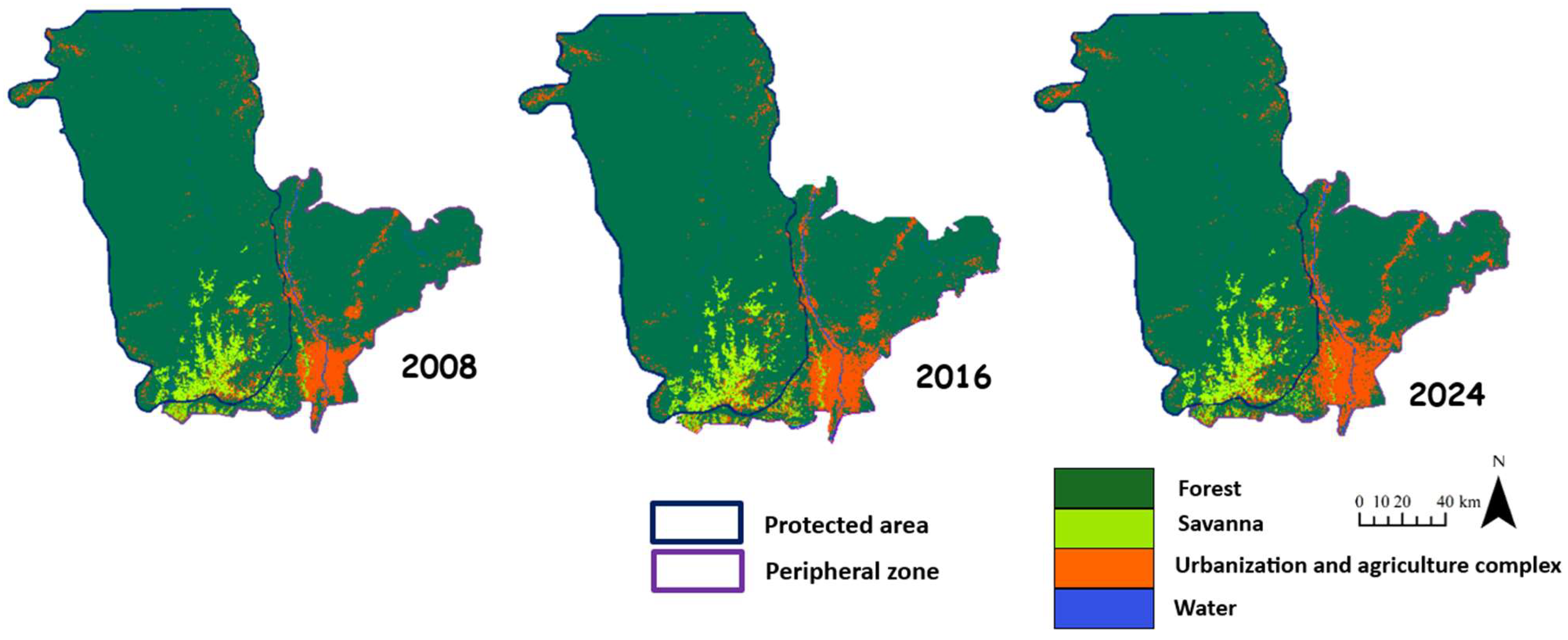
Table 1.
Description and illustration of land cover classes and the number of training zones used in analyzing the landscape dynamics of Lomami National Park and its peripheric zone.
Table 1.
Description and illustration of land cover classes and the number of training zones used in analyzing the landscape dynamics of Lomami National Park and its peripheric zone.
| Land cover class | Description | Illustration | Number of training zones (Polygone) |
|---|---|---|---|
| Forest | Natural land cover class representing areas predominantly covered with trees and dense vegetation. |  |
100 |
| Urbanization and agriculture complex | Anthropogenic land cover class consisting of built-up and bare soil, as well as the adjacent agricultural lands. | 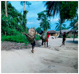 |
100 |
| Water | Natural land cover class including water bodies such as rivers and other water masses. |  |
100 |
| Savannah | Anthropic land cover class characterized by grassy vegetation formations with a cover of tall grasses measuring less than 80 cm in height. | 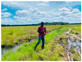 |
100 |
Table 2.
Synthesis of computed landscape metrics
| Index | Ecological signification |
|---|---|
| Class area (CA) | This index measures the total area of all patches within a given land use class. A high total area in natural zones indicates continuity and integrity of ecosystems, whereas a reduced area suggests fragmentation due to anthropogenic activities [55 ,56]. An intact landscape will have a high total area for natural classes, reflecting minimally disturbed ecosystems. |
| Patch number (PN) | This index counts the number of distinct patches or fragments of a class within the landscape. An increase in the number of patches, coupled with a decrease in total area, reveals heightened fragmentation, often resulting from agricultural or urban activities [56]. A high number of patches in a disturbed landscape indicates division into smaller fragments, which reduces habitat connectivity. |
| Largest Pacth Index (LPI) | It represents the proportion of the area occupied by the largest patch of a class relative to the total area of all patches of that land cover class. A high value indicates low fragmentation, suggesting that the land cover class is relatively continuous [57,58]. This reflects a predominant presence of large patches in a minimally disturbed landscape. |
| Disturbance index (U) | This ratio between the cumulative area of anthropogenic classes and that of natural classes measures the predominance of anthropogenic pressure in the landscape [59,60]. A value less than 1 indicates dominance of natural classes, while a value greater than 1 reveals a strong anthropogenic influence. This index helps to understand the impact of human activities on the landscape pattern. |
| Agrégation Index (AI) | It measures the degree of aggregation or dispersion of patches within a class. A high index value indicates that the patches are closely grouped and form continuous blocks, whereas a low index value suggests greater dispersion and fragmentation [61]. This index provides insights into habitat continuity and ecological connectivity. |
| Edge density (ED) | This index quantifies the total length of patch edges per hectare, measuring the roughness of the patches. A high edge density indicates greater complexity of the patches, often associated with increased fragmentation [62]. Edge density provides information on patch structure and the extent of fragmentation. |
Table 3.
Summary of indices illustrating the accuracy of Landsat classified images on the Google Earth Engine geospatial analysis platform for the periods 2008-2016 and 2016-2024. UAC: Urbanization and agriculture complex.
Table 3.
Summary of indices illustrating the accuracy of Landsat classified images on the Google Earth Engine geospatial analysis platform for the periods 2008-2016 and 2016-2024. UAC: Urbanization and agriculture complex.
| 2008-2016 | ||||||||
| Forest | UAC | Water | Savanna | Forest Gain | UAC Gain | Water Gain | Savanna Loss | |
| Pr [%] | 84.22 | 84.25 | 83.22 | 83.34 | 83.12 | 84.23 | 83.55 | 85.22 |
| Pu [%] | 85.25 | 85.22 | 83.56 | 83.46 | 85.12 | 83.12 | 84.38 | 83.34 |
| 95% CI | 0.42 | 0.44 | 0.47 | 0.45 | 0.46 | 0.46 | 0.39 | 0.43 |
| PG | 85.33 | |||||||
| 2016-2024 | ||||||||
| Forest | Rural Complex | Water | Savanna | Forest Gain | Rural Complex Gain | Water Gain | Savanna Loss | |
| Pr [%] | 84.33 | 84.55 | 86.33 | 84.52 | 84.22 | 84.66 | 84.33 | 83.44 |
| Pu [%] | 84.88 | 83.46 | 85.56 | 83.23 | 84.75 | 82.23 | 84.66 | 88.24 |
| 95% CI | 0.36 | 0.41 | 0.42 | 0.48 | 0.38 | 0.47 | 0.42 | 0.46 |
| PG | 85.82 | |||||||
Disclaimer/Publisher’s Note: The statements, opinions and data contained in all publications are solely those of the individual author(s) and contributor(s) and not of MDPI and/or the editor(s). MDPI and/or the editor(s) disclaim responsibility for any injury to people or property resulting from any ideas, methods, instructions or products referred to in the content. |
© 2024 by the authors. Licensee MDPI, Basel, Switzerland. This article is an open access article distributed under the terms and conditions of the Creative Commons Attribution (CC BY) license (http://creativecommons.org/licenses/by/4.0/).
Copyright: This open access article is published under a Creative Commons CC BY 4.0 license, which permit the free download, distribution, and reuse, provided that the author and preprint are cited in any reuse.


