
Submitted:
26 January 2026
Posted:
30 January 2026
You are already at the latest version
Abstract
Adaptive reuse projects frequently entail major plan-level reorganisation, yet the reconfiguration of spatial hierarchy within interior layouts remains underexplored at the building scale. Background: This study investigates how spatial hierarchy is reconfigured during the adaptive reuse of an industrial building converted into a hotel, focusing on the spatial implications of programme-driven design decisions within unchanged architectural boundaries. Methods: Visibility-based Space Syntax analyses were conducted using visual integration, connectivity, and mean depth measures. Rather than relying on floor-level averages, a control-point-based comparative approach was employed to enable targeted before-and-after comparisons directly linked to plan-level architectural interventions. Results: The findings indicate that spatial accessibility and visual integration are selectively intensified at specific nodal locations on the ground floor, while upper floors maintain a more controlled and segregated spatial structure. This pattern reveals a vertical redistribution of spatial hierarchy aligned with programme requirements, rather than a uniform transformation across the building. Conclusions: The results demonstrate that spatial transformation in adaptive reuse cannot be interpreted solely through quantitative accessibility changes, but should be understood as a design-driven reorganisation of spatial priorities. Rather than seeking statistical generalisation, this study offers a transferable, design-oriented analytical framework for interpreting plan-level spatial transformations in adaptive reuse projects involving similar programme changes.
Keywords:
adaptive reuse
; spatial hierarchy
; space syntax
; visibility graph analysis
; plan-level configuration
; design-oriented analysis
1. Introduction
Adaptive reuse is an architectural strategy that aims to transform and reprogram existing building stock and has gained increasing importance in the contexts of sustainability, cultural continuity, and urban resilience. In particular, the conversion of industrial heritage buildings into hospitality, cultural, or public uses has been widely addressed both in architectural practice and in academic literature [1,2,3]. Recent studies have further examined such transformations through the lens of spatial experience, highlighting how adaptive reuse interventions reshape perceptual and configurational qualities in former industrial buildings [4]. However, a substantial portion of this discourse evaluates adaptive reuse processes primarily through structural interventions, energy performance, economic sustainability, or cultural values, while the transformation of plan-level spatial organization and spatial hierarchy is often treated as a secondary concern.
Yet programmatic transformation entails not only a change of functions but also a fundamental reconfiguration of interior spatial organization, circulation relationships, and spatial priorities. Such plan-level transformations necessitate the re-establishment of spatial hierarchies that directly shape user experience. Despite this, studies that examine interior plan layouts and spatial hierarchy through quantitative and comparative approaches remain limited within the adaptive reuse literature [5,6].
The Space Syntax approach, developed for the analysis of spatial configuration, enables the interpretation of interior spatial organization through measures of accessibility, connectivity, and hierarchical relationships [7,8,9]. Nevertheless, a large proportion of Space Syntax–based studies focus on the urban scale, while building-scale analyses tend to rely on multiple cases and offer generalized readings based on average values [10,11]. Studies that compare the pre- and post-intervention conditions of a single building at the plan level within the same architectural boundaries remain relatively limited.
Within this context, the primary gap in the literature lies in the lack of systematic, visibility-based analytical investigations that reveal how spatial hierarchy is redistributed at the plan level and across different floors during the adaptive reuse process. In particular, the ways in which spatial relationships between the ground floor and upper floors change following programmatic transformation—and how these changes can be related to plan-level design decisions—have not been sufficiently discussed.
Accordingly, the aim of this study is to examine how spatial hierarchy is reconfigured at the plan level during the conversion of an industrial building into a hotel. Through visibility-based Space Syntax analyses, the study compares pre- and post-intervention spatial configurations within the same architectural boundaries and evaluates, within an analytical framework, how program-driven design decisions are reflected in accessibility, circulation patterns, and spatial priorities.
In this context, the study contributes to the literature in three main respects. First, it demonstrates that spatial hierarchy in adaptive reuse processes is not uniformly strengthened or weakened across the building as a whole; rather, it is selectively redistributed across different floors in accordance with plan-level design decisions. Second, by conducting before-and-after comparisons within the same architectural boundaries, the study enables the observed spatial changes to be interpreted not as the result of contextual or formal differences, but as outcomes directly related to program-driven architectural interventions. Third, the study approaches visibility-based Space Syntax analyses not as tools for producing statistical generalizations, but as a design-oriented analytical framework that allows spatial hierarchy to be interpreted through architecturally meaningful decision nodes within the plan organization.
Accordingly, the study addresses the following research questions:
• RQ1: How is spatial hierarchy restructured at the plan level during the adaptive reuse process?
• RQ2: What differences can be observed between the ground floor and upper floors in terms of spatial hierarchy and accessibility?
• RQ3: What analytical potential do visibility-based Space Syntax measures offer for interpreting this transformation in spatial hierarchy?
The research is structured around the following hypotheses:
• H1: During the adaptive reuse process, spatial integration and accessibility tend to increase at the ground floor.
• H2: Upper floors tend to exhibit a more controlled and segregated spatial structure.
• H3: The transformation of spatial hierarchy does not occur homogeneously across the building as a whole, but selectively across different floors.
Through the use of visibility-based syntactic measures as an interpretive design tool, this study contributes to the literature by demonstrating how spatial hierarchy is selectively reconfigured at the plan level during the adaptive reuse process. These hypotheses are not intended to test generalizable causal relationships, but rather to structure and guide an interpretive, design-oriented analytical reading of plan-level spatial transformation within a single case study.
1.1. Conceptual Framework: Spatial Hierarchy as an Architectural Construct
1.1.1. The Concept of Spatial Hierarchy
Spatial hierarchy is a fundamental organizational principle defined through the degrees of accessibility, circulation relationships, and spatial priorities offered by architectural space to its users. In architectural theory, this concept has been addressed through various perspectives, including center–periphery relationships, the public–private distinction, and the gradation of transitions between spaces [12,13]. Within this framework, spatial hierarchy derives its meaning not solely from the size of spaces or their functional classifications, but from their positions within the relational network formed by spatial connections.
The relational nature of spatial hierarchy is articulated particularly clearly in the Space Syntax approach developed by Hillier and Hanson [14]. This approach suggests that configurational arrangements between spaces influence user movement patterns, wayfinding behaviour, and spatial experience. Accordingly, architectural space is understood not as a passive physical container, but as a relational system that actively structures social and functional interactions.
In the context of this study, spatial hierarchy is not treated as a normative design criterion or a performance indicator, but as a spatial construct that is produced and transformed through plan-level architectural decisions. This perspective recognizes spatial hierarchy as a dynamic phenomenon that can be reconfigured in response to programmatic transformation and design interventions, rather than as a fixed or inherent property.
1.1.2. Spatial Hierarchy and Circulation at the Plan Level
Plan organization constitutes one of the primary architectural levels at which spatial hierarchy can be most directly observed. The visual and physical relationships established between spaces, the continuity of circulation networks, and the positioning of threshold spaces are among the key factors that determine how spatial priorities are distributed within the plan [15]. For this reason, the plan level is understood not only as a functional arrangement but also as a framework that embodies the relational structure of architectural design.
Concepts such as visual fields, wayfinding, and spatial continuity play a critical role in interpreting the perceptual dimension of spatial hierarchy at the plan level. This relationship between plan configuration and spatial understanding has been extensively discussed in studies on the development of users’ topological knowledge of building layouts [16]. Spaces in which visual relationships are concentrated are often perceived as spatial centers, whereas visually and physically segregated areas tend to be identified as secondary or more controlled zones of use [17,18]. This suggests that spatial hierarchy is produced not solely through functional distributions, but also through user experience and perceptual guidance mechanisms.
Within the context of this study, the plan level is approached not as a fixed schematic arrangement, but as a dynamic structure that is continuously reconfigured through circulation decisions, visual continuities, and threshold spaces. This perspective assumes that plan organization represents one of the primary analytical planes through which spatial transformation in adaptive reuse processes can be examined.
1.1.3. Spatial Hierarchy in the Context of Adaptive Reuse
Adaptive reuse projects often require existing spatial hierarchies to be reconsidered in response to new programmatic requirements. Programmatic change frequently results in the redefinition of existing circulation schemes, spatial centers, and access relationships; within this process, spatial hierarchy may in some cases be preserved, in others weakened, or reconfigured altogether [9,19]. This variability indicates that spatial hierarchy in the context of adaptive reuse does not produce a singular or predictable outcome.
Recent literature emphasizes that the preservation of spatial continuity in adaptive reuse projects is not always possible or necessary; instead, spatial priorities required by new functions are selectively reproduced through targeted design interventions [18]. In particular, the conversion of industrial buildings into hospitality or public uses frequently involves opening ground floors to public access while organizing upper floors according to more controlled use scenarios. However, such arrangements should not be regarded as automatic or inevitable outcomes, but rather as spatial choices shaped by plan-level design decisions.
Within this framework, spatial hierarchy in adaptive reuse is approached not as a static heritage attribute, but as a dynamic architectural construct that is redefined through programmatic transformation and plan-level design decisions. This perspective assumes that the transformation of spatial hierarchy can be analytically traced most effectively through relational readings conducted at the plan level.
1.1.4. Analytical Readings of Spatial Hierarchy
Reading spatial hierarchy at the plan level requires the systematic and comparable analysis of relationships between spaces. The Space Syntax approach offers a set of methods that enable the analytical examination of spatial hierarchy by rendering spatial relationships visible through quantitative measures [20]. In particular, visibility-based analyses contribute to tracing relational patterns in plan organization by addressing issues such as circulation potential, wayfinding behaviour, and the identification of spatial centers within interior environments.
However, when such analyses assess spatial hierarchy solely through numerical performance indicators, the relationships between architectural configuration and design decisions risk being overlooked. While numerous studies have demonstrated strong relationships between Space Syntax measures and pedestrian movement patterns, such correlations do not fully capture the architectural logic underlying spatial hierarchies [21]. For this reason, visibility-based analyses are most effectively interpreted in conjunction with plan-level architectural interventions rather than being limited to the production of quantitative outputs. Recent studies published in Buildings likewise emphasize the importance of addressing spatial analyses within a design-oriented and interpretive framework [22,23]. This perspective highlights spatial hierarchy not merely as a measurable condition, but as a phenomenon that acquires meaning within its architectural context.
In this study, spatial hierarchy is therefore approached not as a normative design criterion or performance metric, but as an architectural construct produced and transformed through plan-level design decisions. Accordingly, visibility-based Space Syntax analyses are employed not to quantify the extent to which spatial transformation occurs, but to make visible how and where such transformation is produced within the plan organization. This analytical framework enables the interpretation of changes in spatial hierarchy in direct relation to architectural design decisions.
2. Materials and Methods
The methodology adopted in this study is structured as a multi-stage and systematic process, extending from the review of relevant literature to analytical evaluation. The research is grounded in an analytical framework aimed at examining plan-level transformations in spatial hierarchy within the context of adaptive reuse. Accordingly, the selection of the case building, the preparation of spatial data, the execution of visibility-based configurational analyses, and the interpretation of the resulting findings in relation to plan organization and design decisions are addressed as sequential stages.
The overall methodological framework and the analytical steps followed in the study are schematically summarized in Figure 1. The presented workflow diagram illustrates that the spatial analyses are not treated as independent technical outputs, but are interpreted in direct relation to plan-level architectural interventions.
2.1. Case Building and Analytical Scope
The building examined in this study is a former industrial structure located in the city center of Bandırma, directly connected to the port and ferry terminal, and situated within a dense urban fabric (Figure 2). Currently reused as a hospitality facility, the building—through its relationship with the surrounding multi-storey residential context and transportation infrastructure—provides a suitable case for examining plan-level spatial transformations in the context of adaptive reuse. The urban context of the building is presented through the study area visualization, which situates the case at national, regional, and city scales while simultaneously illustrating its immediate surroundings and existing physical condition (Figure 2). The building’s compact plan structure, limited number of floors, and absence of major structural alteration make it particularly suitable for isolating the effects of program-driven plan-level reconfiguration.
In this context, the building is approached not as a representative example, but as an analytical prototype that enables the examination of how plan-level decisions associated with programmatic transformation affect spatial hierarchy through before-and-after comparisons conducted within the same architectural boundaries. Accordingly, the analysis focuses on comparing pre- and post-intervention spatial configurations within identical architectural limits. This approach allows the observed configurational changes to be interpreted as outcomes related to program-driven architectural interventions rather than to differences in scale, context, or building footprint.
Although the building is situated within a dense urban environment, the analytical focus of the study is deliberately confined to interior spatial configuration. The urban context is considered as a background condition shaping programmatic requirements, while the primary objective of the study is defined as analytically discussing how plan-level design interventions reorganize spatial hierarchy.
2.2. Visibility Graph Analysis
Spatial configuration was analysed using visibility-based Space Syntax methods in order to examine transformations in accessibility, connectivity, and depth relationships during the adaptive reuse process. At the building scale, Visibility Graph Analysis (VGA) was selected due to its ability to represent visual fields and circulation potential within interior spaces at a detailed plan-level resolution. The applicability of VGA at the micro scale has been demonstrated in previous building-scale studies, where visibility-based measures were used to interpret spatial configuration in relation to architectural use and movement [24]. The VGA method enables the fine-grained examination of continuous visual spaces and inter-spatial relationships, making it particularly suitable for analysing interior transformations associated with hospitality programmes.
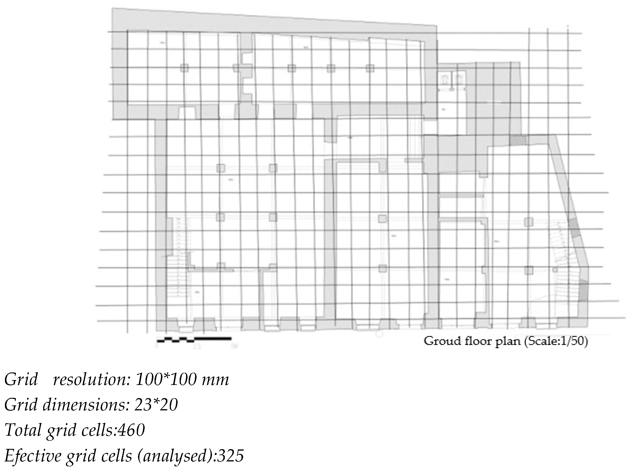
The analyses were conducted using grid-based visibility graphs with a resolution of 100 × 100 mm. This resolution allows spatial continuity and segregation patterns within the interior to be represented with sufficient analytical detail. On the ground floor, a total of 460 grid cells were generated, of which 325 were included in the analysis after excluding obstructed or inaccessible areas. Although the total number of grid cells varied across floors in accordance with plan geometry, the same grid resolution and analytical parameters were consistently applied across all floors and in both pre- and post-intervention configurations to ensure methodological comparability. The ground-floor configuration is illustrated in the supplementary material (Figure A1) as a representative example of the analytical setup; variations in effective grid cell numbers across upper floors result from differences in plan geometry rather than changes in analytical resolution or parameters.
All analyses were conducted using a global VGA approach (radius = n), which allows the relationship of each grid cell to the entire spatial system to be evaluated and was preferred in order to capture the overall relational structure of each floor rather than localized visibility effects alone. The primary syntactic measures employed in the analysis are as follows:
• Visual Integration: a relational indicator of global accessibility and wayfinding potential;
• Connectivity: representing local visual connections and immediate spatial relationships;
• Mean Depth: reflecting spatial segregation and hierarchical distance within the system.
These measures are not treated as normative indicators of spatial performance, but rather as analytical references that enable the interpretation of how plan-level architectural decisions redistribute spatial priorities within the building. All VGA values reported in the analysis are raw (non-normalized) measures; absolute magnitudes are not interpreted, and analytical emphasis is placed exclusively on relative configurational changes between pre- and post-intervention conditions within identical architectural boundaries.
2.3. Selection of Control Points: Comparative Approach and Rationale
Rather than relying on generalized interpretations based on global statistical averages, the analysis adopts a comparative, design-oriented control-point-based approach. This method focuses on spatial nodes with high architectural and functional relevance that are directly associated with the transformation process, allowing plan-level changes to be examined in a more targeted and interpretable manner.
The control points (M1–M6) were identified according to the following four explicit criteria:
• circulation decision nodes where users encounter directional choices or experience spatial transitions;
• locations representing spatial centrality in both pre- and post-intervention conditions, with functionally equivalent roles within the plan;
• threshold spaces between public, semi-public, and private zones, where changes in spatial hierarchy and access control become most evident;
• areas directly subjected to architectural intervention, including reconfigured circulation cores, redistributed programme areas, and newly introduced spatial connectors.
These control points do not represent specific rooms or spaces, but rather critical relational nodes within the plan organisation where spatial hierarchy is produced, directed, or transformed. Accordingly, they are treated not as discrete spatial units, but as analytical references where circulation, visibility, and access relationships are concentrated. By prioritising configurational significance over abstract statistical averages, this approach foregrounds design-driven spatial differentiation by examining where, how, and in which directions plan-level architectural decisions reshape spatial hierarchy during the adaptive reuse process.
The visual integration, connectivity, and mean depth values employed in this study are non-normalised (raw) syntactic measures. Rather than enabling inter-building comparisons based on absolute values, the analysis focuses on revealing relative configurational changes between pre- and post-intervention conditions within identical architectural boundaries. By comparing the same control points across both configurations, the analysis does not ask whether accessibility increases uniformly across the system, but instead identifies where and how spatial priorities are deliberately intensified, maintained, or withdrawn through plan-level design decisions. In this way, the control-point-based approach foregrounds architectural intent over statistical abstraction and establishes a design-oriented analytical perspective for interpreting spatial hierarchy.
3. Results
3.1. Comparative Analysis of Ground-Floor Spatial Configuration
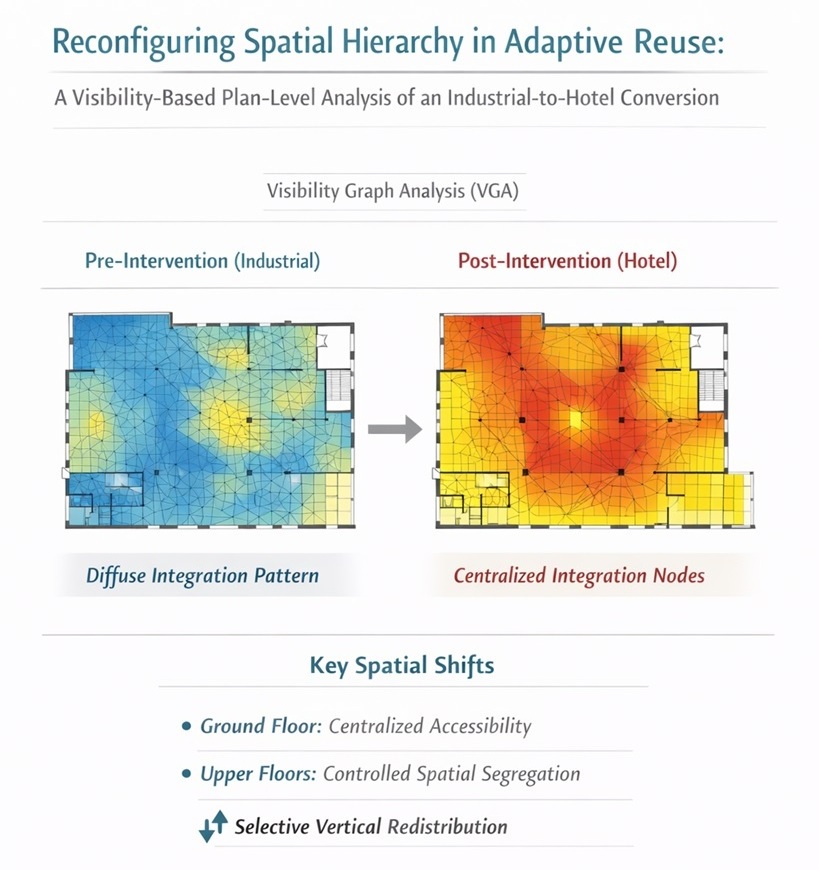
The spatial configuration of the ground floor was analysed through a comparison of pre- and post-intervention conditions in order to examine the effects of the adaptive reuse process on accessibility, connectivity, and spatial depth. Visual integration, connectivity, and mean depth values derived from Visibility Graph Analysis (VGA) allow both overall spatial patterns and local changes at the selected control points (M1–M6) to be evaluated concurrently.
In the post-intervention condition, the visual integration pattern on the ground floor is observed to be redistributed and extended across a wider area (Figure 3b). Notable increases in integration values occur particularly within reconfigured main circulation zones and spaces opened to public use. In contrast, areas allocated to service functions or more controlled uses retain comparatively lower levels of integration.
Connectivity values indicate that, in the pre-intervention condition, visual relationships between spaces were more fragmented and limited. In the post-intervention configuration, connectivity values increase notably within main circulation areas and shared-use spaces, indicating strengthened spatial continuity and a more coherent configuration of visual connections.
Mean depth values reveal that, in the pre-intervention configuration, even some publicly accessible spaces exhibited relatively high levels of spatial depth. In the post-intervention condition, mean depth values decrease in principal public areas, while increasing in spaces allocated to more private or secondary uses.
Visual integration, connectivity, and mean depth values for the control points identified on the ground floor (M1–M6) are presented in Table 1. The comparative results indicate that changes in spatial configuration do not occur as a uniform increase or decrease across the system; rather, they are concentrated at specific nodal locations, where spatial priorities are selectively redefined through plan-level interventions.
3.2. Upper Floors: Comparative Analysis of Spatial Configuration
The first and second floors are evaluated together under the heading of “upper floors” due to the observation of comparable spatial behaviour patterns. The spatial configuration of these floors was analysed by comparing pre- and post-intervention conditions using visual integration, connectivity, and mean depth measures.
3.2.1. First Floor
In the pre-intervention configuration of the first floor, visual integration values are observed to exhibit a limited and dispersed pattern, with no clearly defined spatial centre across the floor (Figure 4a). Connectivity values likewise display a low and irregular distribution, suggesting a fragmented structure of spatial relationships.
In the post-intervention condition, an overall decrease in integration and connectivity values is observed (Figure 4b). While the spatial pattern becomes more homogeneous, it remains low in intensity, with integration levels remaining limited particularly in areas allocated to private uses.
Syntactic values for the selected control points on the first floor are presented in Table 2. These values indicate that changes in spatial configuration are concentrated at specific nodal locations, while overall accessibility across the floor remains comparatively limited.
4.2.2. Second Floor
In the pre-intervention configuration of the second floor, visual integration and connectivity values are generally low, indicating a spatial structure characterised by segregation (Figure 5a). Mean depth values further suggest relatively high hierarchical distances of spaces within the overall spatial system.
In the post-intervention configuration, although only limited changes are observed in visual integration and connectivity values, the overall character of the spatial pattern is largely preserved (Figure 5b). Increases in mean depth values in certain spaces indicate a clearer articulation of spatial segregation across the floor.
Syntactic values for the control points identified on the second floor are presented in Table 3. The results indicate that a similar overall profile in accessibility and connectivity is maintained between the pre- and post-intervention conditions, while variations in mean depth reflect changes in the relative segregation of specific nodal locations.
4. Discussion
Rather than pursuing multiple-case comparisons aimed at statistical generalisation, this research is structured as an analytical case study that examines the plan-level spatial transformation of a single building undergoing adaptive reuse. The investigated building is approached not as a representative example, but as an analytical prototype that enables the effects of programme-driven design decisions on spatial hierarchy to be traced through before-and-after comparisons conducted within the same architectural boundaries. This approach prioritises explanatory depth and architectural interpretability over quantitative generalisation and seeks to make the role of spatial configuration in the design process explicit.
The study examines how spatial configuration is restructured during the adaptive reuse process through visibility-based Space Syntax analyses conducted at the plan level. The findings suggest that spatial transformation cannot be explained solely through increases or decreases in accessibility values; rather, spatial hierarchy is selectively redistributed across floors. These results are consistent with recent studies in the adaptive reuse literature that seek to relate functional and cultural dimensions to the measurable properties of spatial configuration [2,25].
4.1. Redistribution of Spatial Hierarchy
The comparison of pre- and post-intervention spatial configurations indicates that spatial hierarchy is not eliminated across the building; instead, it is rescaled in response to programme transformation. This observation aligns with Space Syntax literature that conceptualises spatial hierarchy not as a fixed attribute, but as a dynamic system that can be reproduced and modified through architectural design decisions [14,26].
Recent studies have shown that, in adaptive reuse projects, spatial continuity is rarely preserved in a one-to-one manner; instead, selective interventions responding to new programme requirements tend to prevail [2,3]. By demonstrating that such redistribution can be traced at the plan level through visibility-based syntactic measures, the present study clarifies the relationship between plan-level architectural decisions and spatial transformation.
4.2. Ground-Floor Centralisation of Spatial Hierarchy
Findings related to the ground floor indicate that spatial accessibility becomes concentrated at specific nodal locations, positioning this level as the primary reference plane within the building. This pattern is consistent with architectural approaches commonly observed in adaptive reuse projects involving hospitality and public functions, where the ground floor is often conceived as a public interface [18].
Within the Space Syntax framework, the concentration of visual integration and connectivity values suggests that the ground floor functions as the focal level of spatial hierarchy. Similar tendencies have been discussed in recent studies published in Buildings, particularly in relation to ground-floor centralisation, wayfinding clarity, and public accessibility [19]. However, rather than treating this centralisation as an inevitable outcome of programme requirements, the present study interprets it as a spatial condition that can be associated with specific plan-level design decisions.
4.3. Weakening of Spatial Hierarchy and Vertical Differentiation on Upper Floors
Findings related to the first and second floors indicate that lower levels of visual integration and connectivity are maintained in comparison to the ground floor. While such forms of vertical spatial differentiation may appear programmatically expected in buildings converted to hospitality functions, the results suggest that this outcome is not automatic; rather, it emerges through specific plan-level design decisions that can be analytically traced. The observation of similar spatial behaviour patterns on both floors further indicates that the upper levels are addressed within a shared spatial and programmatic logic.
Increases in mean depth values reflect a clearer articulation of spatial segregation and hierarchical distance on the upper floors. Importantly, this differentiation should not be interpreted as a decline in spatial performance or spatial quality. As emphasised in the Space Syntax literature, lower levels of integration and connectivity are often associated with functional outcomes such as privacy, controlled access, and programmatic separation and are therefore appropriate within certain spatial programmes [10,15].
In this context, the reconfiguration of spatial hierarchy observed on the upper floors can be read as a counterpart to the concentration of public accessibility at the ground floor. This vertical differentiation indicates not a restriction of spatial access, but the production of a spatial gradient aligned with use scenarios. The before-and-after comparisons conducted within identical architectural boundaries demonstrate that this transformation results not from contextual or scale-related differences, but from plan-level design decisions. Moreover, the control-point-based comparative analysis moves beyond generalised interpretations based on average values, enabling the tracing of critical nodal locations through which spatial meaning is produced. In this sense, vertical differentiation can be interpreted as a design outcome rather than a purely programmatic given.
5. Conclusion
This study has examined the spatial outcomes of the adaptive reuse process at the plan level through visibility-based Space Syntax analyses. Focusing on the conversion of an industrial building into a hospitality programme, the findings demonstrate that spatial transformation cannot be explained solely through quantitative shifts in accessibility values. Instead, spatial hierarchy is selectively redistributed across floors through plan-level design decisions.
The analyses indicate that spatial accessibility and visual integration are concentrated at specific nodal locations on the ground floor, while upper floors retain a more controlled and segregated spatial pattern. This configuration suggests that spatial hierarchy is not uniformly intensified or weakened across the building as a whole, but selectively rescaled in accordance with programme requirements. In this sense, spatial configuration should be understood not as a passive by-product of adaptive reuse, but as an active design component shaped through architectural intervention.
By focusing on a single building, the study enables a detailed examination of the internal logic of spatial transformation rather than the production of generalisable results. The before-and-after comparisons conducted within identical architectural boundaries demonstrate that the observed spatial changes arise directly from plan-level design decisions, rather than from contextual or scale-related differences. This analytical focus highlights the interpretive potential of visibility-based syntactic analyses when they are situated within an architectural design framework rather than employed as purely quantitative evaluation tools.
Rather than seeking statistical generalisation, this study provides a transferable, design-oriented analytical framework for interpreting plan-level spatial transformations in adaptive reuse projects. By reading syntactic measures through architecturally meaningful control points, the proposed approach offers a way to relate configurational change directly to architectural intent. In this respect, the framework may inform future analyses of adaptive reuse projects involving similar programme transformations, particularly where interior spatial hierarchy and circulation play a critical role.
At the same time, the study is subject to certain limitations. As an analytical case study, its findings are not intended to represent all adaptive reuse contexts, nor to establish universal causal relationships between programme change and spatial configuration. Future research could expand this approach through comparative studies across multiple buildings or by integrating additional analytical perspectives, such as user movement observations or post-occupancy evaluations, to further explore how plan-level spatial transformations are experienced in use.
Supplementary Materials
The following supporting information can be downloaded at the website of this paper posted on Preprints.org. Figure S1 illustrates the grid-based analytical setup used for Visibility Graph Analysis (VGA), showing the ground-floor plan overlaid with a 100 × 100 mm visibility grid. Obstructed and inaccessible areas were excluded from the analysis. The ground floor is presented as a representative example of the analytical configuration; variations in effective grid cell numbers across upper floors result from differences in plan geometry rather than changes in analytical resolution or parameters.
Author Contributions
Conceptualization,Onur Suta and Mehmet Fatih Aydın; Methodology, Onur Şuta and Mehmet Fatih Aydın; Software, Onur Şuta and Mehmet Fatih Aydın; Validation, Onur Şuta and Mehmet Fatih Aydın; Formal analysis, Onur Suta and Mehmet Fatih Aydın; Investigation, Onur Suta and Mehmet Fatih Aydın; Resources, Onur Suta and Mehmet Fatih Aydın;Data curation, Onur Suta and Mehmet Fatih Aydın; Writing—original draft preparation, Onur Suta and Mehmet Fatih Aydın; Writing—review and editing, Onur Suta and Mehmet Fatih Aydın; Visualization, Onur Suta and Mehmet Fatih Aydın; Supervision, Onur Suta and Mehmet Fatih Aydın; Project administration, Onur Suta and Mehmet Fatih Aydın; All authors have read and agreed to the published version of the manuscript.
Funding
This research received no external funding, , and the APC was funded by the authors.
Informed Consent Statement
Informed consent was obtained from all subjects involved in the study.
Data Availability Statement
The data presented in this study are available on request from the corresponding author. The data are not publicly available due to privacy and ethical restrictions.
Conflicts of Interest
The authors declare no conflict of interest: The authors declare no conflicts of interest. The funders had no role in the design of the study; in the collection, analyses, or interpretation of data; in the writing of the manuscript; or in the decision to publish the results.
Appendix
This appendix includes one supplementary figure.
Appendix 1.
Figure A1.
Ground-floor plan overlaid with the 100 × 100 mm visibility graph grid used for Visibility Graph Analysis (VGA). Obstructed and inaccessible areas were excluded from the analysis.
Figure A1.
Ground-floor plan overlaid with the 100 × 100 mm visibility graph grid used for Visibility Graph Analysis (VGA). Obstructed and inaccessible areas were excluded from the analysis.
References
- Yung, E.H.K.; Chan, E.H.W. Implementation challenges to the adaptive reuse of heritage buildings: Towards the goals of sustainable, low carbon cities. Habitat International 2012, 36, 352–361. [Google Scholar] [CrossRef]
- Plevoets, B.; Van Cleempoel, K. Adaptive reuse as a strategy towards conservation of cultural heritage: A literature review. Structural Studies, Repairs and Maintenance of Heritage Architecture 2019, 13, 155–164. [Google Scholar]
- Foster, G.; Saleh, R. The adaptive reuse of cultural heritage in European Circular City Plans: A systematic review. Sustainability 2021, 13, 2889. [Google Scholar] [CrossRef]
- Mesda, Y.; Kurt, S. Industrial heritage buildings in Cyprus: Spatial experience of the Nicosia Municipal Arts Centre. Planning Perspectives 2021, 36, 1–21. [Google Scholar] [CrossRef] [PubMed]
- Langston, C. The sustainability implications of building adaptive reuse. Structural Survey 2012, 30, 26–44. [Google Scholar]
- Bullen, P.A.; Love, P.E.D. Adaptive reuse of heritage buildings. Structural Survey 2011, 29, 411–421. [Google Scholar] [CrossRef]
- Wilkinson, S.; Remøy, H.; Langston, C. Sustainable Building Adaptation: Innovations in Decision-Making; Wiley-Blackwell: Chichester, UK, 2014. [Google Scholar]
- Conejos, S.; Langston, C.; Smith, J. Designing for future building adaptive reuse. Architectural Science Review 2013, 56, 13–26. [Google Scholar]
- Foster, G. Circular economy strategies for adaptive reuse of cultural heritage buildings. Buildings 2020, 10, 25. [Google Scholar] [CrossRef]
- Van Nes, A.; Yamu, C. Introduction to Space Syntax in Urban Studies; Springer: Cham, Switzerland, 2021. [Google Scholar]
- Askarizad, R.; Lamíquiz Daudén, P.J.; Garau, C. The Application of Space Syntax to Enhance Sociability in Public Urban Spaces: A Systematic Review. ISPRS Int. J. Geo-Inf. 2024, 13, 227. [Google Scholar] [CrossRef]
- Hillier, B.; Hanson, J. The Social Logic of Space; Cambridge University Press: Cambridge, UK, 1984. [Google Scholar]
- Hillier, B. Space Is the Machine; Cambridge University Press: Cambridge, UK, 1996. [Google Scholar]
- Bafna, S. Space syntax: A brief introduction to its logic and analytical techniques. Environment and Behavior 2003, 35, 17–29. [Google Scholar] [CrossRef]
- Psarra, S. Architecture and Narrative: The Formation of Space and Cultural Meaning; Routledge: London, UK, 2009. [Google Scholar]
- Haq, S.; Zimring, C. Just down the road a piece: The development of topological knowledge of building layouts. Environment and Behavior 2003, 35, 132–160. [Google Scholar] [CrossRef]
- Penn, A. Space syntax and spatial cognition: Or why the axial line? Environment and Behavior 2003, 35, 30–65. [Google Scholar] [CrossRef]
- Kim, Y.O.; Penn, A. Linking the spatial syntax of cognitive maps to the spatial syntax of the environment. Environment and Behavior 2004, 36, 483–504. [Google Scholar] [CrossRef]
- Dursun, P. Space syntax in architectural design. Architectural Design 2007, 77, 56–65. [Google Scholar] [CrossRef]
- Haq, S.; Luo, Y. Space Syntax in Healthcare Facilities Research: A Review. Health Environments Research & Design Journal bunu mevcut 8 in yerine. 2012, 5(4), 98–117. [Google Scholar]
- Sharmin, S.; Kamruzzaman, M. Meta-analysis of the relationships between space syntax measures and pedestrian movement. Transport Reviews 2018, 38, 524–550. [Google Scholar] [CrossRef]
- Hölscher, C.; Brösamle, M.; Vrachliotis, G. Challenges in multilevel wayfinding: A case study with space syntax. Environment and Planning B 2012, 39, 63–82. [Google Scholar] [CrossRef]
- Moosavi, S.; Trigueiro, A.; D’Onghia, A. Spatial configuration and social interaction in residential architecture: An interpretive space syntax approach. Buildings 2023, 13(2), 144. [Google Scholar] [CrossRef]
- Van Nes, A.; López, M. Micro scale spatial analysis of workplaces: A visibility graph analysis approach. Buildings 2018, 8, 42. [Google Scholar] [CrossRef]
- Paulino, D. M. S.; Celani, G.; Vaz, C. E. V. A Grammar-Based Approach for Generating Spatial Layout Solutions for the Adaptive Reuse of Historic Buildings. Buildings 2023, 13(3), 722. [Google Scholar] [CrossRef]
- Langston, C.; Wong, F.K.W.; Hui, E.C.M.; Shen, L.-Y. Strategic assessment of building adaptive reuse opportunities in Hong Kong. Building and Environment 2008, 43, 1709–1718. [Google Scholar] [CrossRef]
Figure 1.
Workflow diagram of the study.
Figure 2.
Location of the former Tekel building (Panderma Hotel) in the city of Bandırma, showing its urban context, immediate surroundings, and current physical condition.
Figure 2.
Location of the former Tekel building (Panderma Hotel) in the city of Bandırma, showing its urban context, immediate surroundings, and current physical condition.
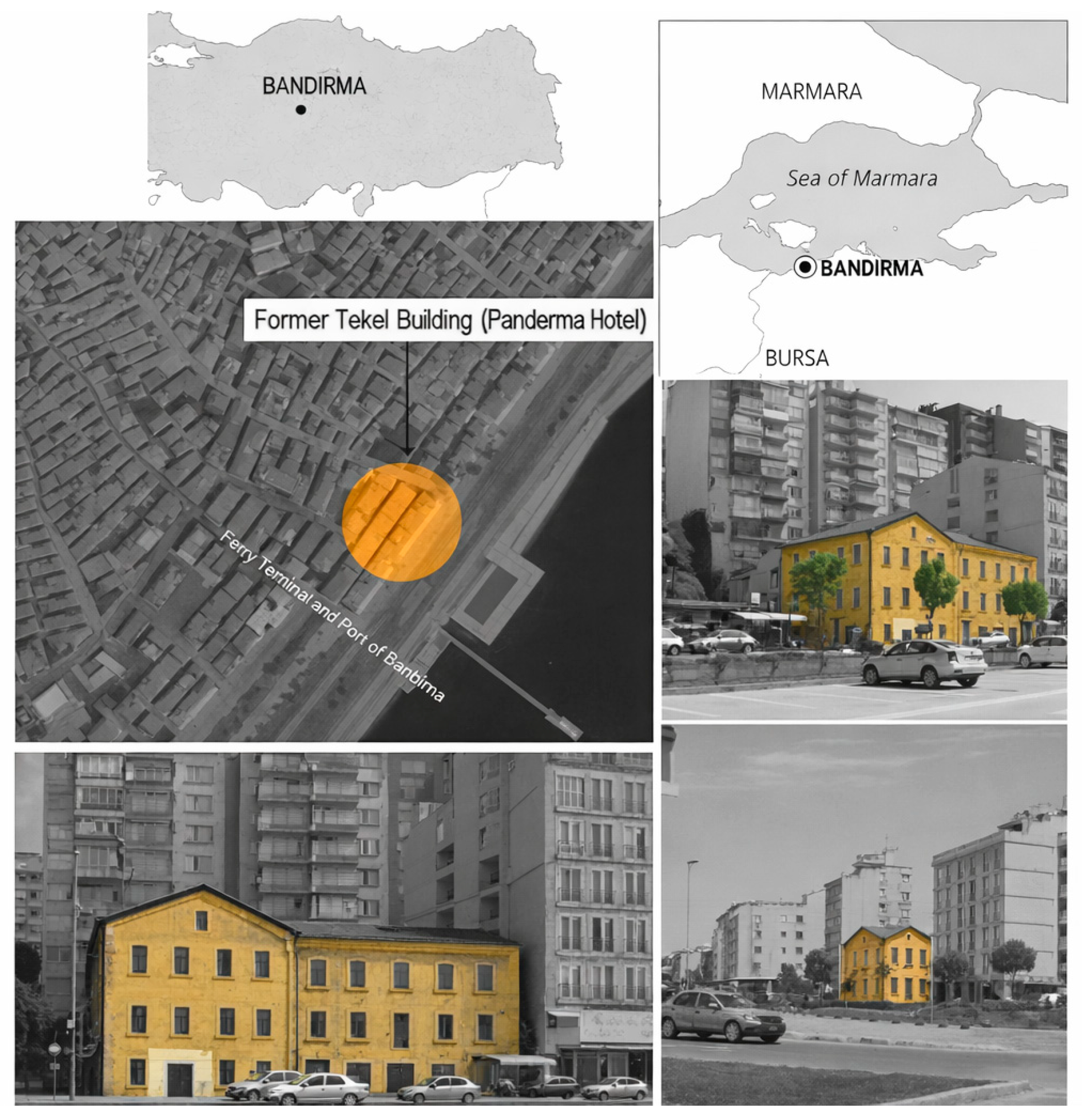
Figure 3.
Visibility-based spatial configuration of the ground floor: (a) pre-intervention condition, (b) post-intervention condition. Note: Control points M1–M6 indicate the selected analytical nodes.
Figure 3.
Visibility-based spatial configuration of the ground floor: (a) pre-intervention condition, (b) post-intervention condition. Note: Control points M1–M6 indicate the selected analytical nodes.
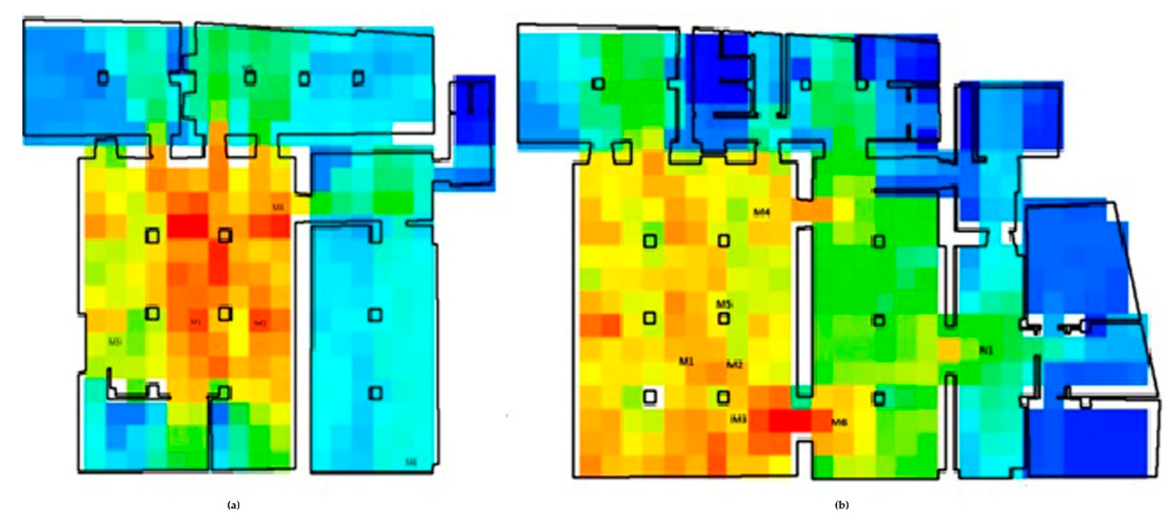
Figure 4.
Visibility-based spatial configuration of the first floor: (a) pre-intervention condition, (b) post-intervention condition. Note: Control points M1–M6 indicate the selected analytical nodes. The figure supports the plan-level comparison discussed in Section 4.2.1.
Figure 4.
Visibility-based spatial configuration of the first floor: (a) pre-intervention condition, (b) post-intervention condition. Note: Control points M1–M6 indicate the selected analytical nodes. The figure supports the plan-level comparison discussed in Section 4.2.1.
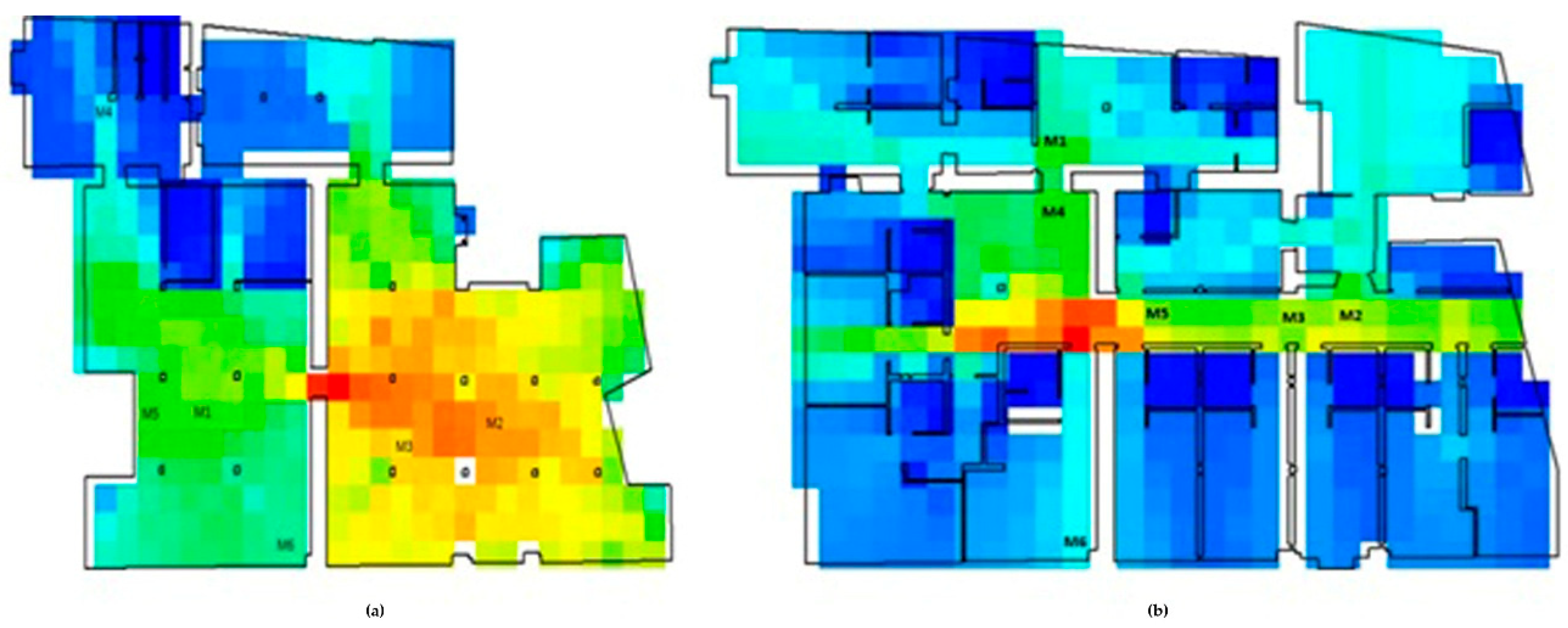
Figure 5.
Visibility-based spatial configuration of the second floor: (a) pre-intervention condition, (b) post-intervention condition. Note: Control points M1–M6 indicate the selected analytical nodes.
Figure 5.
Visibility-based spatial configuration of the second floor: (a) pre-intervention condition, (b) post-intervention condition. Note: Control points M1–M6 indicate the selected analytical nodes.
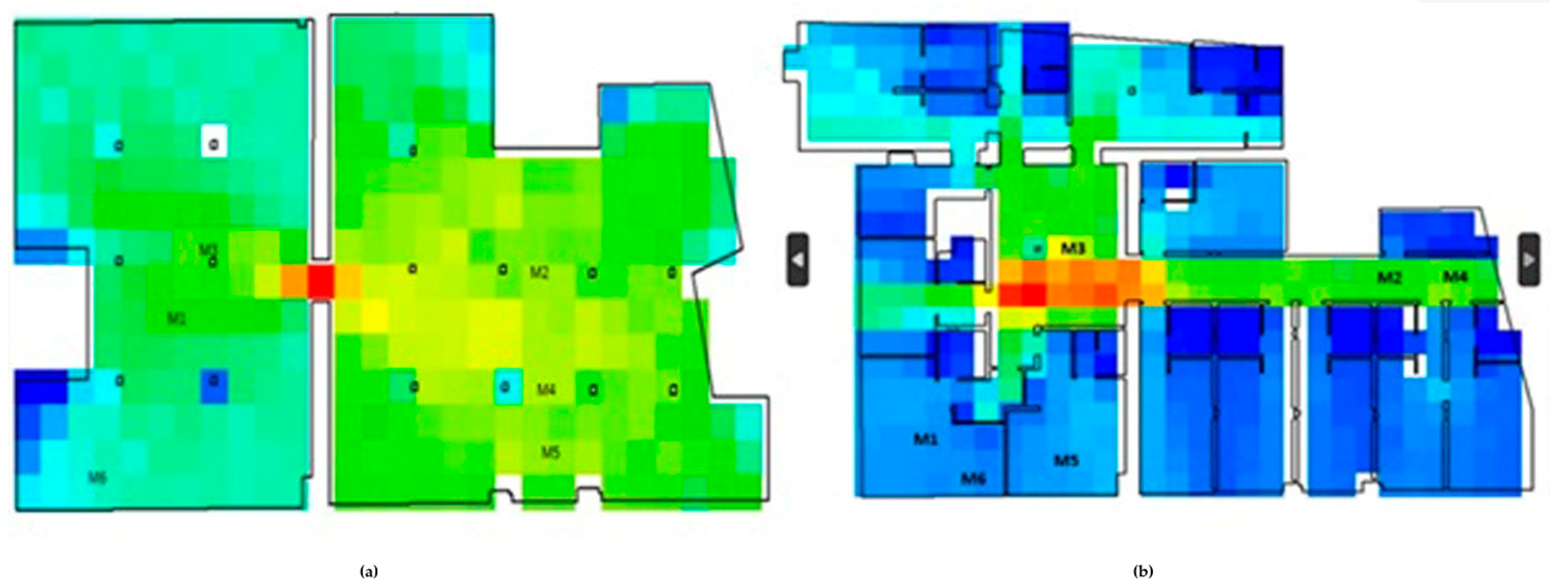

Table 1.
Visual integration, connectivity, and mean depth values for the control points (M1–M6) identified on the ground floor. Note: Δ Integration indicates the difference between the post-intervention and pre-intervention conditions.Values are interpreted comparatively rather than as absolute performance indicators.
| Point | Integration (Existing) | Integration (Restored) | Δ Integration | Conn. (Existing) | Conn. (Restored) | Mean depth (Existing) | Mean depth (Restored) |
|---|---|---|---|---|---|---|---|
| M1 | 19348.01 | 29918.91 | +10570.90 | 115 | 136 | 1.92 | 2.03 |
| M2 | 18408.18 | 30312.87 | +11904.69 | 109 | 139 | 1.76 | 2.01 |
| M3 | 5869.70 | 2401.25 | −3468.45 | 47 | 14 | 2.27 | 2.84 |
| M4 | 11035.77 | 30684.94 | +19649.17 | 63 | 140 | 2.05 | 1.85 |
| M5 | 7514.70 | 255.81 | −7258.89 | 54 | 3 | 2.23 | 4.58 |
| M6 | 16269.37 | 31249.92 | +14980.55 | 98 | 141 | 2.05 | 1.95 |
Table 2.
Visual integration, connectivity, and mean depth values for the control points (M1–M6) identified on the first floor.
Table 2.
Visual integration, connectivity, and mean depth values for the control points (M1–M6) identified on the first floor.
| Point | Integration (Existing) | Integration (Restored) | Δ Integration | Conn. (Existing) | Conn. (Restored) | Mean depth (Existing) | Mean depth (Restored) |
|---|---|---|---|---|---|---|---|
| M1 | 27901.29 | 5248.98 | −22652.31 | 125 | 40 | 1.81 | 2.83 |
| M2 | 42202.85 | 9399.06 | −32803.79 | 174 | 61 | 1.68 | 2.44 |
| M3 | 41745.25 | 9497.05 | −32346.19 | 171 | 61 | 1.69 | 2.44 |
| M4 | 11709.76 | 7808.54 | −3901.22 | 68 | 54 | 2.23 | 2.65 |
| M5 | 26681.65 | 8767.00 | −17914.65 | 122 | 53 | 1.81 | 2.50 |
| M6 | 19613.98 | 8482.44 | −11131.54 | 91 | 51 | 2.18 | 2.52 |
Note: Δ Integration indicates the difference between the post-intervention and pre-intervention conditions. Values are interpreted comparatively rather than as absolute performance indicators.
Table 3.
Visual integration, connectivity, and mean depth values for the control points (M1–M6) identified on the second floor.
Table 3.
Visual integration, connectivity, and mean depth values for the control points (M1–M6) identified on the second floor.
| Point | Integration (Existing) | Integration (Restored) | Δ Integration | Conn. (Existing) | Conn. (Restored) | Mean depth (Existing) | Mean depth (Restored) |
|---|---|---|---|---|---|---|---|
| M1 | 43702.81 | 2135.14 | −41567.67 | 155 | 30 | 1.51 | 4.29 |
| M2 | 51317.13 | 7275.08 | −44042.05 | 168 | 49 | 1.49 | 2.46 |
| M3 | 45912.80 | 10416.41 | −35496.39 | 162 | 72 | 1.49 | 2.21 |
| M4 | 52197.06 | 7647.80 | −44549.26 | 171 | 53 | 1.47 | 2.41 |
| M5 | 50118.08 | 2245.81 | −47872.27 | 166 | 26 | 1.49 | 3.81 |
| M6 | 32175.94 | 2468.39 | −29707.55 | 119 | 28 | 1.64 | 3.00 |
Note: Δ Integration indicates the difference between the post-intervention and pre-intervention conditions. Values are interpreted comparatively rather than as absolute performance indicators.
Disclaimer/Publisher’s Note: The statements, opinions and data contained in all publications are solely those of the individual author(s) and contributor(s) and not of MDPI and/or the editor(s). MDPI and/or the editor(s) disclaim responsibility for any injury to people or property resulting from any ideas, methods, instructions or products referred to in the content. |
© 2026 by the authors. Licensee MDPI, Basel, Switzerland. This article is an open access article distributed under the terms and conditions of the Creative Commons Attribution (CC BY) license (http://creativecommons.org/licenses/by/4.0/).
Copyright: This open access article is published under a Creative Commons CC BY 4.0 license, which permit the free download, distribution, and reuse, provided that the author and preprint are cited in any reuse.


