
Submitted:
18 January 2026
Posted:
19 January 2026
You are already at the latest version
Abstract
In this study, we employed the 5-meter Accuracy Digital Elevation Model (DEM) developed by the Geospatial Information Authority of Japan, to analyze the spatial distribution of Yayoi-period archaeological sites. Rather than relying on conventional regional cross-tabulations—such as prefecture-level classifications—this approach adopts a Geographic Information System (GIS)–based analysis that enables higher spatial precision as well as more intuitive and visually accessible interpretation. Through this methodology, we aim to reconstruct the geographical conditions of ancient Japan at the end of the Yayoi period, approximately 1,800 years ago, and to offer a new perspective on the long-standing debate concerning the location of Yamatai (Yamataikoku). The results of analyses using the 5m DEM substantially increase the likelihood that Yamatai was located in northern Kyushu. In addition, northern Kyushu exhibits highly distinctive patterns of land use that vary markedly by region. The areas surrounding present-day Asakura City and Ogori City appear to have been specialized primarily for military purposes. In contrast, the Yoshinogari site—one of the largest Yayoi-period settlements in Japan—shows a pronounced specialization in agriculture, particularly large-scale wet-rice cultivation. The area corresponding to modern Fukuoka City, meanwhile, functioned as a major urban center in which both military and agricultural functions were concentrated. Furthermore, the “Jimmu’s Eastern Expedition” undertaken by the first Emperor Jimmu cannot necessarily be dismissed as a purely legendary event; it likely reflects certain historical facts. By introducing a GIS-based approach that has been relatively underutilized in previous research, this study serves as a pilot project while simultaneously representing an ambitious attempt to expand the horizons of visualization in ancient Japanese historical studies.
Keywords:
GIS
; Yayoi
; Japan
; Yamatai
; Himiko
; Jimmu
1. Introduction
In the field of ancient history studies conducted by Japanese researchers, approaches primarily based on philological analysis and archaeological excavation findings have dominated until now. Recently, however, research methodologies that actively incorporate digital technologies have begun to emerge, albeit at an exploratory stage. Examples include large-scale data processing that leverages remote sensing and image analysis techniques, such as studies of the Nazca Lines in Peru [1], as well as airborne laser scanning (LiDAR)-based surveys of burial mound groups [2]. In addition, efforts aimed at generating new insights—such as the automated detection of burial mounds through AI-based map analysis [3]—are gradually advancing.
Nevertheless, for major themes in ancient Japanese history, particularly those that are widely debated, comprehensive analytical frameworks that integrate data science methodologies and Geographic Information Systems (GIS) remain scarce. Moreover, within Japan, methodological frameworks that utilize large-scale, interdisciplinary datasets to evaluate historical theories in ways that are not only statistically rigorous but also visually intuitive have yet to be fully established.
Against this backdrop, the present study utilizes research data that are currently relatively easy to obtain and attempts to analyze the spatial distribution of Yayoi-period archaeological sites using the “5-meter Accuracy Digital Elevation Model (DEM)” (hereafter, 5m DEM) developed by the Geospatial Information Authority of Japan (hereafter, GSI) [4]. Through this approach, the study aims to reconstruct the geographical conditions of ancient Japan approximately 1,800 years ago and to provide a new perspective on the long-standing debate concerning the location of Yamatai.
2. Yamatai Queendom (Yamataikoku)
2.1. Overview of Yamatai
Yamatai Queendom (Yamataikoku, hereafter, Yamatai) known as a powerful political confederation that unified multiple small polities in the Japanese archipelago during the third century CE, occupies a central position in discussions of early Japanese state formation (Table 1). Descriptions of its political structure and historical context rely heavily on the Records of the Three Kingdoms (Sanguozhi), specifically in the Wei Shu section on the Eastern Barbarians, commonly referred to as the “Account of the Wa People” (Wei Zhi Woren Zhuan, hereafter, Wei Zhi).
Around 1,800 years ago, during the late Yayoi period, the Japanese archipelago (then referred to as Wa) was engulfed in prolonged internal conflict beginning in the latter half of the second century CE, commonly known as the “Great Disturbance of Wa” (Wakoku Tairan). This turmoil was eventually resolved when various polities collectively enthroned a single female ruler, Himiko, as queen. Himiko’s mode of governance was characterized by a fusion of ritual and political authority grounded in shamanistic practices referred to as “spirit-based rites” (kido). According to the Wei Zhi, Himiko remained secluded within the inner quarters of the palace, fulfilling religious and ritual functions, while her younger brother assisted with practical governance and diplomacy. This arrangement suggests a dual power structure combining sacred authority and administrative leadership.
2.2. Debate over Location
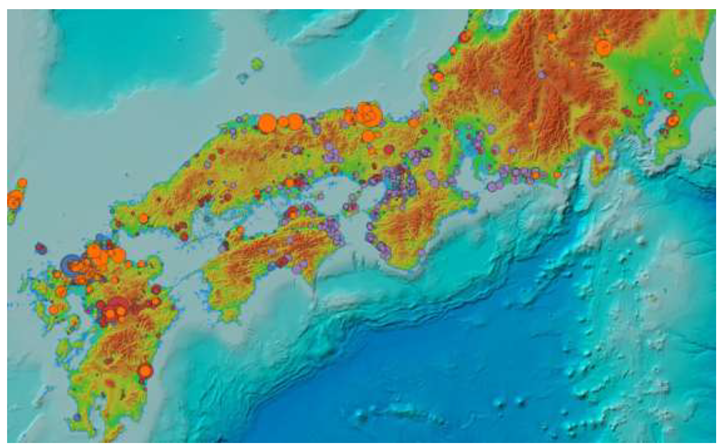
The debate concerning the location of Yamatai dates back to the Edo period, around 300 years ago, beginning with the work of Arai [5,6], and intensified dramatically in 1910 with the publication of the Kyushu theory by Shiratori [7] and the Kinai theory by Naito [8]. Since then, the “Kyushu theory” and the “Kinai theory” have remained in sharp opposition (Figure 1), generating sustained debate within both academic and public spheres [9,10,11,12,13,14,15,16,17,18,19,20,21,22,23,24].
The Kyushu theory identifies candidate locations primarily in northern Kyushu—particularly in present-day Fukuoka, Saga, and Oita prefectures—and emphasizes dense late Yayoi settlement patterns, advanced metallurgical cultures, and geographical proximity to other Wa polities described in the Wei Zhi. In contrast, the Kinai theory regards the Makimuku Site in present-day Sakurai City, Nara Prefecture, as the political core of Yamatai, citing the site’s large scale, chronological correspondence, and distinctive assemblage of artifacts as evidence of its central political role.
Despite extensive research, no decisive evidence—such as the unequivocal identification of Himiko’s tomb or the discovery of a golden royal seal—has yet been obtained. Consequently, the location of Yamatai remains a focal point of scholarly controversy.
2.3. Reasons the Debate Remains Unresolved
For proponents of the Kyushu theory, the most significant challenge lies in explaining the continuity—or lack thereof—between Yamatai and the later Yamato polity. If Yamatai were indeed located in northern Kyushu, it becomes necessary to account for why a powerful Kyushu-based political entity rapidly declined after the late third century, while a new political center emerged in the geographically distant Kinai region. This transition must be explained in political-historical and socio-structural terms.
At present, archaeological and textual evidence capable of clearly elucidating this process of political transformation remains limited. As a result, the issue of political succession constitutes a major theoretical difficulty for the Kyushu theory and contributes substantially to the persistence of the broader debate.
By contrast, the most critical difficulty faced by the Kinai theory lies in its consistency with the directional and distance information recorded in the Wei Zhi (Figure 2). According to this source, Yamatai is said to be reached from Fumi by traveling “southward by water for twenty days, and then overland for one month,” a journey that—even by conservative estimates for the period—would correspond to a distance of well over 1,000km. If this description is taken at face value, the itinerary does not extend as far as the Yamato (Kinai) region.
In order to sustain the Kinai theory, it is therefore necessary to introduce special interpretative assumptions, such as regarding the term “south” as a scribal error for “east,” or arguing that the recorded sailing directions were not based on precise observation. These interpretive adjustments have frequently been criticized as a point of vulnerability in textual criticism, as they rely on conjectural reinterpretation rather than straightforward reading of the source.
2.4. A GIS-Based Approach
The controversy surrounding the location of Yamatai represents one of the longest-standing debates in ancient Japanese historical studies. Traditionally, discussions have relied primarily on philological interpretations of historical texts and archaeological excavation data. However, the descriptions found in the Wei Zhi do not permit a single unambiguous reading, and archaeological materials continue to present challenges related to regional variability and chronological resolution. Consequently, a definitive conclusion has yet to be reached.
In light of these limitations, and against the backdrop of recent advances in digital technology, there is growing recognition of the need to re-examine the problem of Yamatai’s location through the application of Geographic Information Systems (GIS) as a complementary historical and archaeological methodology [27,28]. GIS enables the integrated handling of excavation records, reconstructed paleotopography, and environmental data, and has become an indispensable tool for spatial analysis of site distributions and for modeling ancient human activity areas. Moreover, GIS-based analyses facilitate the visualization of interregional interaction networks and the quantitative assessment of the archaeological impacts of paleoenvironmental change.
Such approaches go beyond the mere re-evaluation of existing materials and propose a new research paradigm. By integrating textual sources, archaeological evidence, and geographical data within a spatial modeling framework, GIS enhances the transparency and reproducibility of theory testing in ancient historical studies. It also provides quantitative foundations that were previously unattainable through purely qualitative reasoning, thereby opening new avenues for research on Yamatai.
In this study, as mentioned in Section 1, we employ the 5-meter Accuracy Digital Elevation Model (DEM), the 5m DEM, developed by the Geospatial Information Authority of Japan, which is relatively easy to access, to analyze the distribution of period-specific archaeological materials. This 5m DEM is a high-resolution digital elevation dataset that represents ground surface elevation at approximately 5-meter horizontal intervals. In Japan, it is primarily derived from airborne laser scanning (LiDAR) data and offers a substantial improvement in topographic detail compared with conventional 10m or 50m DEMs.
2.5. Jimmu’s Eastern Expedition
According to the Nihon Shoki, the official chronicle of the Yamato Court, Emperor Jimmu—the first sovereign of Japan—departed from Hyuga in Kyushu, advanced eastward, and after defeating Nagasunehiko, who had ruled the Yamato area, ascended the throne at Kashihara in Yamato. This episode, known as the “Jimmu’s Eastern Expedition” (Jimmu Tōsei), is traditionally dated to more than two millennia ago, and its historical authenticity has therefore been questioned by a considerable number of scholars.
The campaign is said to have initially aimed at landing by sea in Osaka Bay and penetrating the Yamato basin via the Ikoma mountain range, which would have constituted the shortest route of invasion. After this plan failed, however, the expeditionary force is described as having changed strategy, sailed southward along the Kii Peninsula, landed in Kumano, and then advanced northward, ultimately defeating Nagasunehiko in a renewed engagement.
If this assumption is valid, a high concentration of weapons—particularly iron weapons—should be recovered from the areas surrounding Osaka Bay during the Yayoi period, whereas such artifacts should be comparatively scarce in the Yamato area. Furthermore, in the mountainous Uda area, which is traditionally regarded as a strategic base from which Emperor Jinmu advanced into Yamato, iron weapons should be found in quantities equal to or greater than those from the Yamato lowland.
As will be discussed below, this study employs the same dataset used to analyze the spatial distributions of iron implements, bronze artifacts, and silk textiles in order to examine the hypothesis of the Jimmu’s Eastern Expedition from a quantitative and comparative perspective.
3. Methods for Estimating Location
3.1. Mapping of Archaeological Site Locations
For the regions corresponding to the Kyushu and Kinai theories discussed in Section 2.2, the locations of archaeological sites yielding characteristic Yayoi-period artifacts were plotted and visualized on the 5m DEM. The analysis focuses on artifacts that are regarded as particularly diagnostic for the period during which Yamatai is thought to have existed, namely:
- Yayoi-period bronze mirrors
- Yayoi-period iron arrowheads
- Yayoi-period iron spears (including iron swords, iron blades, and iron halberds)
- Yayoi-period silk textiles
- Yayoi-period bronze bells
The Wei Shi records that one hundred bronze mirrors were bestowed upon the ruler of Yamatai, and also notes that the inhabitants of ancient Japan made use of iron arrowheads, iron spears and silk textiles. For this reason, bronze mirrors and iron weapons are considered indispensable archaeological indicators when evaluating candidate locations for Yamatai. By contrast, although several hundred Yayoi-period bronze bells have been excavated to date, there is no reference whatsoever to bronze bells in the Wei Zhi. This discrepancy suggests that sites located within the political core of Yamatai should yield large quantities of bronze mirrors ,iron weapons and silk textiles, while producing few, if any, bronze bells.
In plotting the distribution of these artifacts within a GIS environment, a weighting scheme was applied to reflect the number of items excavated from each site, thereby accounting for differences in assemblage scale (bronze bells reflect their full length; excluding silk textiles). However, records lacking clear identification of either artifact type or site name were excluded from the analysis in order to ensure data reliability.
3.2. Data Sources and Software Versions
Data Sources
- Bronze mirrors: Shimogaki (2016) [29].
- Iron weapons: Kawagoe (2000) [30].
- Silk textiles: Nunome (1999) [33]
Software Versions
Conversion to Latitude and Longitude
- The University of Tokyo CSV Address Matching Service [35].
3.3. Jimmu’s Eastern Expedition
With regard to the occurrence of iron weapons in the Yamato area (present-day Nara Prefecture) during the Yayoi period, the Hirao-higashi site in Uda—classified as a square-platform burial (hōkei-daijōbo)—is not included in the compilation edited by Kawagoe (2000) [30]. This omission reflects the fact that chronological attributions differ somewhat among researchers. However, according to the prevailing view, square-platform burials belong to the Yayoi period, and multiple sources—including Shimizu (2003) [37], Iwanaga (2010) [38], and the Yamato Yayoi Culture Research Association (2000) [39]—classify this burial type as Yayoi in date.
On this basis, the Hirao-higashi site is included in the present analysis of the Jimmu’s Eastern Expedition when examining the distribution of iron weapons in the Kinai region. Nevertheless, in the analysis presented in Section 3.1, this site is excluded in order to maintain identical conditions with other regions.
4. Results Based on GIS Analysis
4.1. Distribution of Yayoi-Period Bronze Mirrors
4.2. Distribution of Yayoi-Period Iron Arrowheads
4.3. Distribution of Yayoi-Period Iron Spears
4.4. Distribution of Yayoi-Period Silk Textiless
4.5. Distribution of Yayoi-Period Bronze Bells
4.6. Jimmu’s Eastern Expedition
As shown in Table 7 and Figure 8, the number of excavated iron weapons is highest in Osaka Prefecture, which faces Osaka Bay, while within Yamato area (present-day Nara Prefecture), the Uda area (within the the red circle in Figure 8) exhibits a higher concentration than areas outside Uda. The Zeniyakubo site (formerly Tsuge Village), located in a mountainous zone, was also included within the Uda area because of its geographical proximity and similar topographic setting.
4.7. Analysis of Results
Regarding the distribution of bronze mirrors and iron arrowheads, symbols of Yamatai, the Kyushu region shows a significant advantage over the Kinai region in both cases (Table 2, Table 3, Table 4 and Table 5; Figure 3, Figure 4, Figure 5 and Figure 6). In contrast, concerning the distribution of bronze bells, which are not considered to be associated with Yamatai, the Kinai region shows a significant advantage over the Kyushu region (Tabel 6; Figure 7). Based on the above results, it is highly probable that Yamatai Queendom existed in northern Kyushu.
With regard to the Jimmu’s Eastern Expedition, iron weapons are most abundantly recovered in Osaka Prefecture, which faces Osaka Bay, while within Nara Prefecture the Uda area yields a higher number of finds than the rest of the prefecture (Table 7; Figure 8). This spatial pattern is consistent with the account in the Nihon Shoki, which records that the initial attempt to land in Osaka Bay and penetrate the lowland Yamato via the Ikoma Mountains failed, whereas the alternative strategy of landing in Kumano and advancing into Yamato area via Uda was successful. Insofar as archaeological evidence is concerned, the distribution of iron weapons therefore accords with this historical narrative.
5. Discussion
5.1. Functional Differentiation Within Yamatai Queendom
As shown in Table 8, GIS visualization reveals that iron arrowheads—interpreted as indicators of military activity—are highly concentrated in the Asakura area, suggesting that this area likely functioned as a major military center. In contrast, the Yoshinogari area, while recognized as a major center of rice production, appears to have had a relatively limited military function.
By contrast, as shown in Figure 9, the Yamato (Kyushu) area (within the blue circle) exhibits a relatively high level of military-related artifacts in relation to its population size, indicating a more substantial military role. This pattern can be interpreted in a manner consistent with the Wei Zhi, which records the existence of a hostile polity, Kuna (Kunakoku), located to the south of Yamatai (within the blue circle). If Kuna is identified with the present-day Kumamoto area (present-day Kumamoto Prefecture, within the red circle), the observed distribution of iron arrowheads as weapons provides a coherent and rational explanation for the spatial patterning of military functions within northern Kyushu.
5.2. The Chunqiu Style of Numerical Representation
Hoshino [40] presents an important alternative perspective on the itinerary distances and population figures recorded in the Wei Zhi, diverging from conventional interpretations. According to Hoshino, reports of military victories and diplomatic achievements in early Chinese historiography frequently involved substantial exaggeration. On this basis, he argues that the li (mile) values recorded for the route from the Daifeng to Yamatai should not be interpreted using the standard “long mile” (approximately 434m), but rather using a much shorter unit, the so-called “short mile” (approximately 75m), representing only a fraction of the conventional measure.
Hoshino further contends that the same principle should be applied to the recorded travel durations and household numbers (population estimates), proposing that these figures be interpreted as one-tenth of their stated values (Figure 10). As supporting evidence, he points out that Chen Shou, the compiler of the Wei Zhi, is known to have exaggerated numerical values in reports of military success, often employing figures inflated by an order of magnitude. This historiographical practice is traditionally referred to as the “Spring and Autumn style of writing” (Chunqiu bifa), a convention that has been examined in detail by Sun [41].
When the reinterpretation of distance based on the short mile unit is adopted as a working premise, the inclusion of maritime travel (suikō, waterborne movement) in the itinerary from Fumi through Tsuma to Yamatai can be explained in a logically consistent manner. Archaeological site distributions suggest that, from the Yayoi period to the early Kofun period, the Ariake Sea was considerably more extensive than at present, with substantial portions of the Chikushi Plain existing as shallow marine waters or inner bays (Figure 11). Accordingly, topographic reconstruction based on the 5m DEM indicates a high likelihood that waterborne transportation was in fact required along segments of this route.
Furthermore, simulations conducted using the sea-level transgression modeling function of the 30m DEM provided by the Japan Aerospace Exploration Agency (JAXA) [42] suggest that, when contemporaneous sea-level rise and sedimentation processes are taken into account, areas that are presently situated at elevations of approximately 10m may have corresponded to the coastline at the time (Figure 12). This result further supports the plausibility of sustained maritime navigation within the itinerary described in historical sources.
5.3. Jimmu’s Eastern Expedition
As noted above, there is a strong possibility that the Jimmu’s Eastern Expedition reflects a historical reality. According to Mizuno [36], iron arrowheads excavated in the Uda area, the mountainous Yamato area—specifically from Tomb No. 9 at the Daiōzan site [43] and from Tombs No. 6 and 7 at the Hirao-higashi site—closely resemble in the form “willow-leaf” those associated with the Yamato polity (the Yamato Court).
The willow-leaf type is predominantly observed in northern Kyushu [44]. The iron arrowhead excavated from the Zeniyakubo site in the mountainous Uda area also exhibits a willow-leaf morphology [45]. In contrast, iron arrowheads from the Yayoi-period lowland Yamato, differ markedly from these forms. At the Hōkiji site, which is the closest site to the Uda area, an arrowhead with barbs—a type commonly found in the Kinai region—have been excavated [46]. These differences suggest that during the Yayoi period, the Yamato polity had not yet extended its influence into the Kashihara area or the lowland Yamato, and instead remained in Uda.
This interpretation implies that the territorial extent of imperial authority changed little from the reign of Emperor Suizei, the second emperor, through that of Emperor Kaika, the ninth emperor, which is consistent with the Nihon Shoki’s lack of substantive records for these eight rulers. In other words, although Emperor Jimmu is said to have ascended the throne at Kashihara, his actual sphere of control at that time likely did not reach the lowland Yamato, suggesting that he was, in effect, no more than the “Great King of Uda.”
Figure 13.
Yamato Area Sites Where Yayoi-period Iron Weapons were Excavated. Note: Enlarged view of Figure 4 and Figure 5 combined.
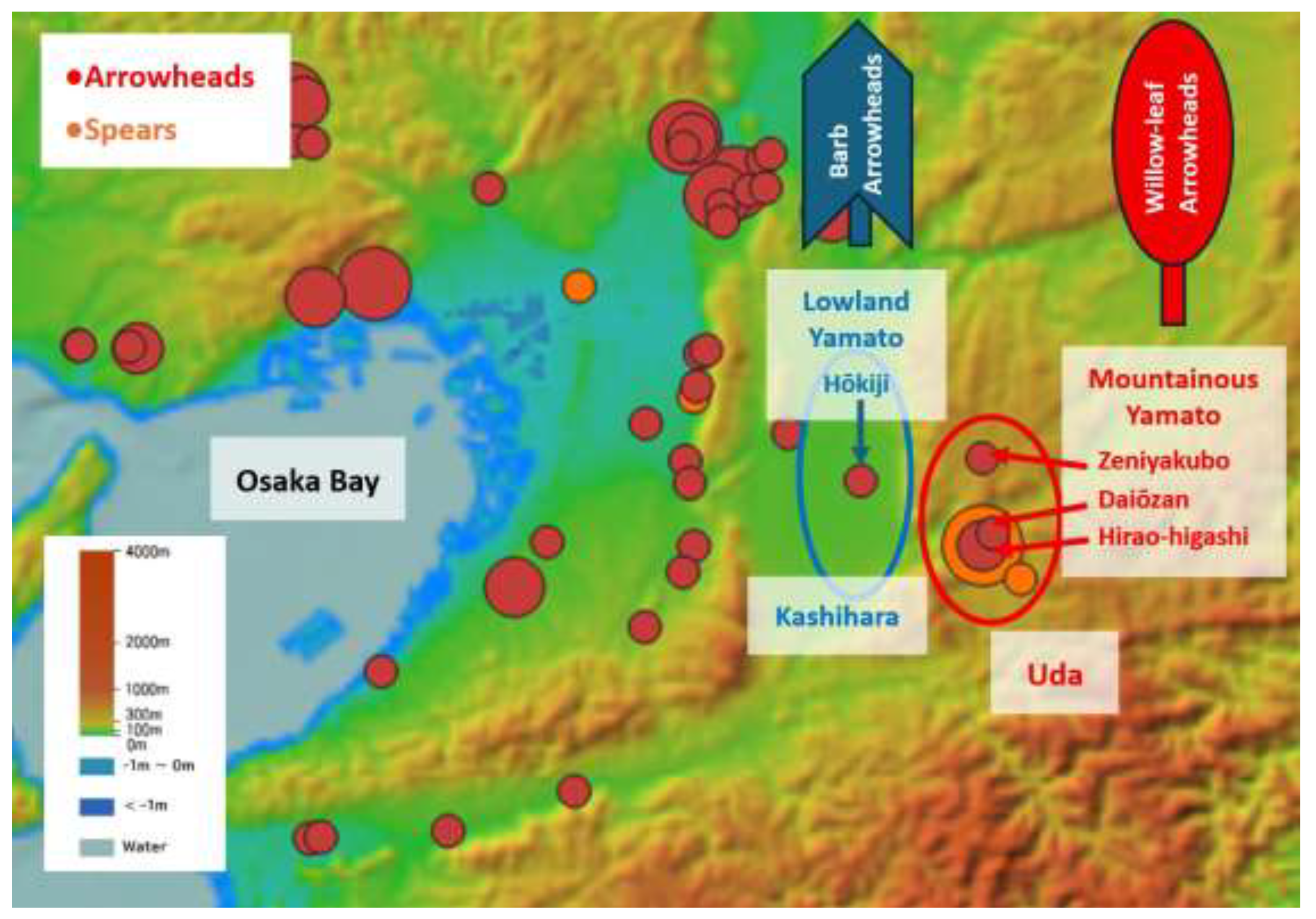
Tomb No. 9 of the Daiōzan site yielded a 16cm willow-leaf type iron arrowhead, the largest known from the Kinai region for this period, and its location corresponds closely to what would be expected for a paramount ruler’s burial [43,44]. For these reasons, the possibility that this tomb represents the mausoleum of Emperor Jimmu cannot be excluded. Moreover, Jimmu and his descendants can be inferred to have maintained close ties with northern Kyushu polities that possessed large quantities of iron weapons.
In addition, the presence in the Uda area of a continuous series of square-platform burials (hōkei-daijōbo) of a form distinct from those found elsewhere in the Yamato area [37,38] suggests that Uda was under the control of Emperor Jimmu and his descendants, a lineage separate from that of Nagasunehiko, the ruler of the lowland Yamato area.
Furthermore, as shown in Figure 14, a simulation of a 10m sea-level rise in Osaka Bay—conducted in the same manner as in Figure 12—indicates that many of the iron weapons of this period were distributed along the coastline. This spatial pattern appears to corroborate the Nihon Shoki’s references to the fast-flowing waters at “Naniwa no Saki” and to “Kusae no Saka,” a coastal location where the first fighting is said to have taken place.
Taken together, these observations suggest that, even if not every detail of the “Jimmu’s Eastern Expedition” is accurate, the narrative is highly likely to reflect a substantial core of historical reality.
6. Conclusion
Using the high-resolution 5m DEM, developed by the GSI, the density distributions of archaeological artifacts that serve as proxies for population size and military capacity. By introducing a GIS-based quantitative and statistical approach that remains relatively rare in existing scholarship, this research constitutes a pilot study while simultaneously representing an ambitious attempt to expand the horizons of visualization in the study of ancient Japanese history.
The results of the data analysis substantially increase the likelihood that the location of Yamatai was situated in northern Kyushu. Within this region—identified as the most probable candidate for Yamatai—distinctive patterns of land use are evident. The areas surrounding present-day Asakura City and Ogori City appear to have been specialized primarily for military functions, whereas the Yoshinogari Site, one of the largest Yayoi-period sites in Japan, exhibits a pronounced specialization in agriculture, particularly large-scale wet-rice cultivation. The area corresponding to modern Fukuoka City, by contrast, functioned as a major urban center in which both military and agricultural roles were concentrated.
Furthermore, the “Jimmu’s Eastern Expedition” undertaken by the first Emperor Jimmu cannot necessarily be dismissed as a purely legendary event; it likely reflects certain historical facts.
Nevertheless, several limitations of the present study must be acknowledged.
First, although high-precision 5m DEM data were employed, the geographical coordinates of archaeological sites could only be converted at the level of urban blocks, rather than at exact excavation points. As a result, a certain degree of spatial error in the GIS plots was unavoidable.
Second, the artifact datasets used in this study were selected primarily on the basis of accessibility. Consequently, some of the data sources date back more than two decades, and it was not possible to fully incorporate the most recent excavation results.
Finally, due to constraints on human and temporal resources, the scope of analysis was limited to northern Kyushu and the central region of Honshu (the Kinai region) and the reflection of site scale and artifact quantity on GIS plots was also limited.
Despite these limitations, it is hoped that future research will address these constraints through the integration of more comprehensive datasets, higher-resolution spatial information, and broader regional coverage. Such efforts have the potential to facilitate a more accurate reconstruction of ancient Japan and to further advance quantitative and visual approaches in ancient historical research.
Supplementary Materials
The following supporting information can be downloaded at the website of this paper posted on Preprints.org.
Acknowledgments
The author expresses sincere gratitude to Dr. Biten Yasumoto, the Yamataikoku Society, the Geospatial Information Authority of Japan, the National Astronomical Observatory of Japan, the members of AsPJT, and related researchers and institutions.
Conflicts of Interest
The author declares no conflict of interest.
Appendix A
References
- Sakai, M.; Sakurai, A.; Lu, S.; et al. AI-accelerated Nazca survey nearly doubles the number of known figurative geoglyphs and sheds light on their purpose. Proceedings of the National Academy of Sciences of the United States of America Available online. 2024, 121, e2407652121. [Google Scholar] [CrossRef] [PubMed]
- Mitsumoto, J.; Ryan, J.; Yamaguchi, Y.; et al. LiDAR survey of the fifth-century Tsukuriyama mounded tomb group in Japan. Antiquity Available online. 2022, 97, 1–8. [Google Scholar] [CrossRef]
- Ohara, K.; Yone, Y.; Mishiro, Y.; et al. Detection of ancient burial mounds from airborne laser scanner data using deep learning. In Proceedings of the Conference of the Remote Sensing Society of Japan, 2024; Available online: https://www.rssj.or.jp/wp-content/uploads/2024/09/p26_76_R06.pdf.
- Geospatial Information Authority of Japan (GSI). GSI Tile Index: Color-Shaded Relief and Elevation Maps. 4. Available online: https://maps.gsi.go.jp/development/ichiran.html.
- Arai, H. Koshi Tsūgiwaku-mon; Questions on Ancient History, 1716; p. 5. [Google Scholar]
- Arai, H. Gaikoku no Koto Chōsho; Memorandum on Foreign Affairs; Volume 6.
- Shiratori, K. Wa Joō Himiko-kō [A Study of the Queen of Wa, Himiko]. In Shigaku Zasshi; (Journal of Historical Studies), 1910. [Google Scholar]
- Naito, K. Himiko-kō [A Study of Himiko]. In Geibun; 1910. [Google Scholar]
- Inoue, M. The Origin of the Japanese State; Iwanami Shoten: Tokyo, 1960; p. 9. [Google Scholar]
- Harada, D. The Yamatai Controversy; Kadokawa Shoten: Tokyo, 1969; p. 10. [Google Scholar]
- Kashihara Archaeology Research. A Study of Triangular-Rimmed Deity-and-Beast Mirrors; Kashihara Archaeology Research Institute: Nara.
- Terasawa, K. Japanese History. In The Birth of Kingship; Kodansha: Tokyo, 2000; Vol. 2. [Google Scholar]
- Kidder, J.E., Jr. Himiko and Japan’s Elusive Chiefdom of Yamatai: Archaeology, History, and Mythology; University of Hawai‘i Press: Honolulu, 2007; p. 13. [Google Scholar]
- Ogo, A. A civil engineer’s geography of Yamatai country in the third century. Journal of Historical Studies in Civil Engineering Available online. 2007, 14 26, 97–106. [Google Scholar] [CrossRef]
- Wakai, T. The Fall of Yamatai: The Conquest by the Yamato Polity; Yoshikawa Kobunkan: Tokyo, 2010. [Google Scholar]
- Inoue, Y. Reconstructing the Route to Yamatai through Cursive Script: A Calligrapher’s Reading of the Wei Zhi; Azusa Shoin: Fukuoka, 2019; p. 16. [Google Scholar]
- Ishii, H. Polities of the Yamatai Period and the Makimuku Royal Center; Shinsensha: Tokyo, 2019. [Google Scholar]
- Sekikawa, N. The Yamatai-in-Yamato Theory from an Archaeological Perspective: Why Yamatai Could Not Have Been in the Kinai; Azusa Shoin: Fukuoka, 2020; p. 18. [Google Scholar]
- Fujii, S. Reconsidering Prehistoric Japan: Paleolithic, Jōmon, Yayoi, and Kofun Periods; Chuo Koron Shinsha: Tokyo, 2021; p. 19. [Google Scholar]
- Yasumoto, Y. Yamatai through Data Science: Northern Kyushu Theory Remains Unshaken; Asahi Shimbun Publishing: Tokyo, 2021; p. 20. [Google Scholar]
- Ogawa, S.; Taniguchi, Y. Fractal analysis for Akamura mounded tomb and location estimate of Yamatai country. ISPRS Archives Available online. 2020, 21 XLIII-B4, 161–168. [Google Scholar] [CrossRef]
- Kanazawa, M. A Scientific Study of Ancient Japanese History: Exploring the Mysteries of the Jomon People, Yamatai, the Nihon Shoki, and the Imperial Line through DNA and AI; Choeisha: Tokyo, 2022; p. 22. [Google Scholar]
- Hoga, T. Original Image of “Jimmu’s Eastern Expedition”, New ed.; Aogaki Publishing: Nara, 2022; p. 23. [Google Scholar]
- Han, H. Study on the Location of Yamatai-koku and the Inscriptions on Seven-Branched Sword. Barun Academy of History Available online. 2025, 24 25, 7–66. [Google Scholar] [CrossRef]
- Fujiwara, S. The Establishment and Expansion of Moat-Encircling Settlements in the Yayoi Period. SOKENDAI (The Graduate University for Advanced Studies). 2011. Available online: http://www.initiative.soken.ac.jp/journal_bunka/110329_fujiwara/fujiwara.pdf.
- AsPJT. PAX SAPIENTICA Dataset: Moated Settlements. Available online: https://github.com/AsPJT/PAX_SAPIENTICA/blob/develop/Data/Features/EastAsia/Yaponesia/Kango.tsv.
- Expanding the frontiers of historical studies through data analysis (I). In Journal of Historical Studies; Kenkyukai, Rekishigaku, Ed.; 2024; p. 27. [Google Scholar]
- Archaeology Data Service & Digital Antiquity. Guides to Good Practice. Available online: https://archaeologydataservice.ac.uk/help-guidance/guides-to-good-practice/.
- Shimogaki, H. Comprehensive Catalogue of Bronze Mirrors Excavated from the Japanese Archipelago; Doseisha: Tokyo, 2016. [Google Scholar]
- Comprehensive Survey of Yayoi-Period Iron Artifacts (East Asia Place-Name Table 2); Kawagoe, T., Ed.; Hiroshima University: Hiroshima, 2000. [Google Scholar]
- Shimane Prefectural Board of Education; et al. Report on Bronze Artifact Deposition Sites. In Shimane Prefectural Ancient Culture Center Research Report; 2002; 12. [Google Scholar]
- AsPJT. PAX SAPIENTICA Dataset: Bronze Bells (Dotaku). Available online: https://github.com/AsPJT/PAX_SAPIENTICA/blob/develop/Data/Items/EastAsia/Yaponesia/Dotaku.tsv.
- Nunome, J. Eastward Spread of Silk: Origins and Evolution of Clothing; Shogakukan: Tokyo, 1999. [Google Scholar]
- QGIS Development Team. QGIS Geographic Information System. Available online: https://qgis.org/.
- Center for Spatial Information Science, The University of Tokyo. CSV Address Matching Service. Available online: https://geocode.csis.u-tokyo.ac.jp/home/csv-admatch/.
- Mizuno, T. Aspect of Iron Weapons from the Early Kofun Period in Uda: Hirao East Tombs No. 6 and 7. Seiryo 2022, 165, 4–8. Available online: https://www.kashikoken.jp/under_construction/wp-content/uploads/2022/03/seiryo165.pdf.
- Shimizu, S. Yayoi Period Square Ditched Tombs and Platform Tombs in Yamato. Kashihara Archaeology Research Institute Bulletin 2003, 14, 125–159. [Google Scholar]
- Iwanaga, S. The Historical background of the growth of chieves and the development of burial mounds during the Yayoi period in Japan. Bulletin of Kyushu University Museum 2010, 8, 17–42. Available online: https://www.museum.kyushu-u.ac.jp/publications/bulletin/008/08-2.pdf.
- Yamato Yayoi Culture Research Association. Available online: http://www.yayoi.sakuraweb.com/cyber-mizuho/deta/sonota.html.
- Hoshino, M. Yamatai: The Final Conclusion; BookWay: Tokyo, 2020. [Google Scholar]
- Sun, R. The Complete Solution to Yamatai: How the Chinese Official Histories Explain Everything; Genshisha: Tokyo, 2018. [Google Scholar]
- Japan Aerospace Exploration Agency (JAXA). Sea Level Rise Simulator. 42. Available online: https://data.earth.jaxa.jp/app/sea-level-rise/.
- Kashihara Archaeological Research. Daiōzan Site, Haibara Town, Uda. District, Nara Prefecture; Haibara Town Board of Education: Nara, 1977. [Google Scholar]
- Kawagoe, T. Iron Age Culture of Yayoi Period; Yuzankaku: Tokyo, 1993; p. 44. [Google Scholar]
- Kashihara Archaeology Research. Zeniyakubo Site, Tsuge Village; Tsuge Village Board of Education: Nara, 1989. [Google Scholar]
- Kashihara Archaeology Research Institute. Hōkiji Site. Nara Prefecture Archaeological Survey Summary Report FY 1982 1983, 2, 365–378. [Google Scholar]
Figure 1.
Principal Yayoi-period Moted Settlements Note: The size of the circle reflects the size of the moat [4,25,26].

Figure 2.
Route to Yamatai Queendom (Wei Zhi).
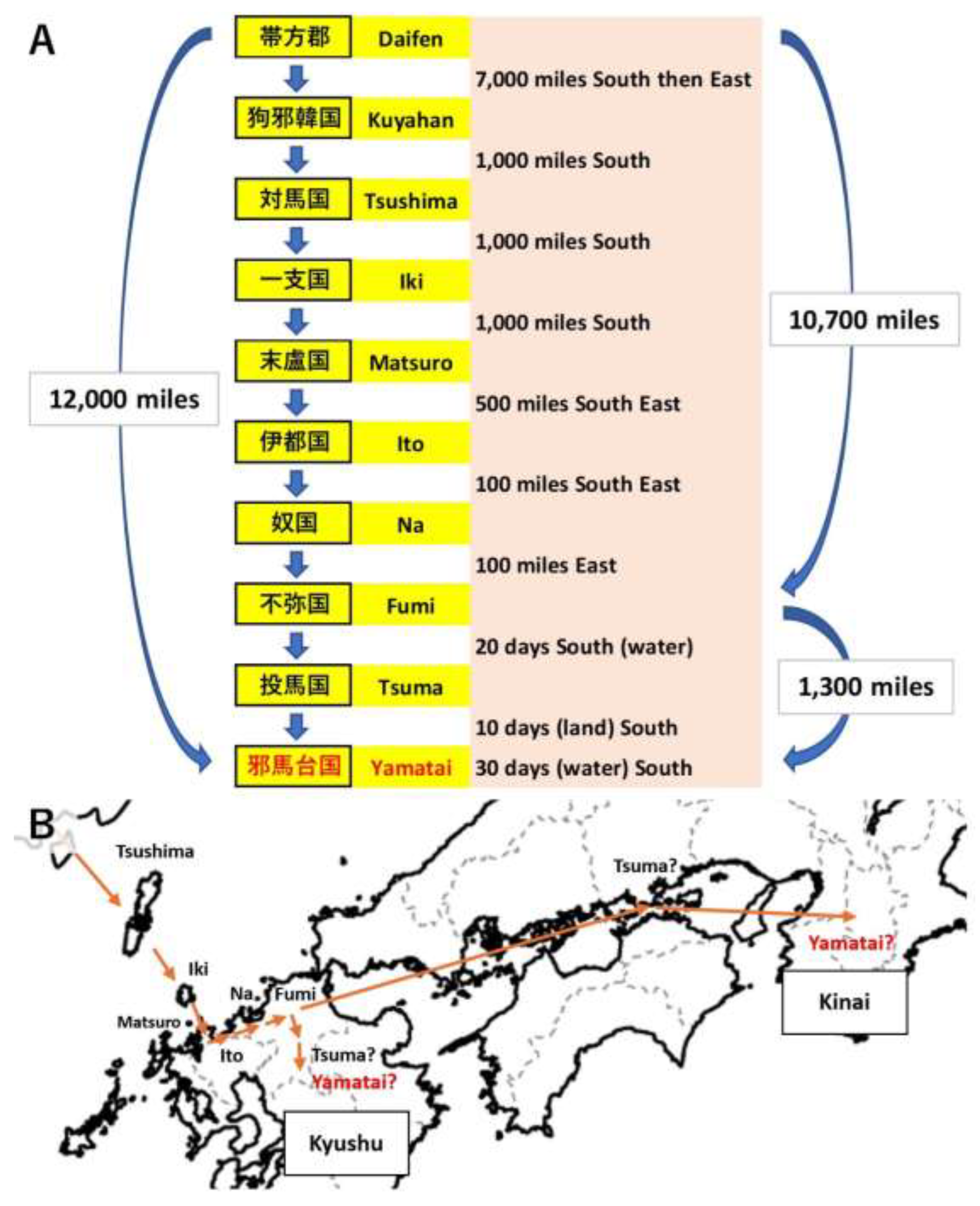
Figure 3.
Distribution of Yayoi-Period Bronze Mirrors. Note: The size of the circle reflects the number of artifacts excavated at the site.
Figure 3.
Distribution of Yayoi-Period Bronze Mirrors. Note: The size of the circle reflects the number of artifacts excavated at the site.
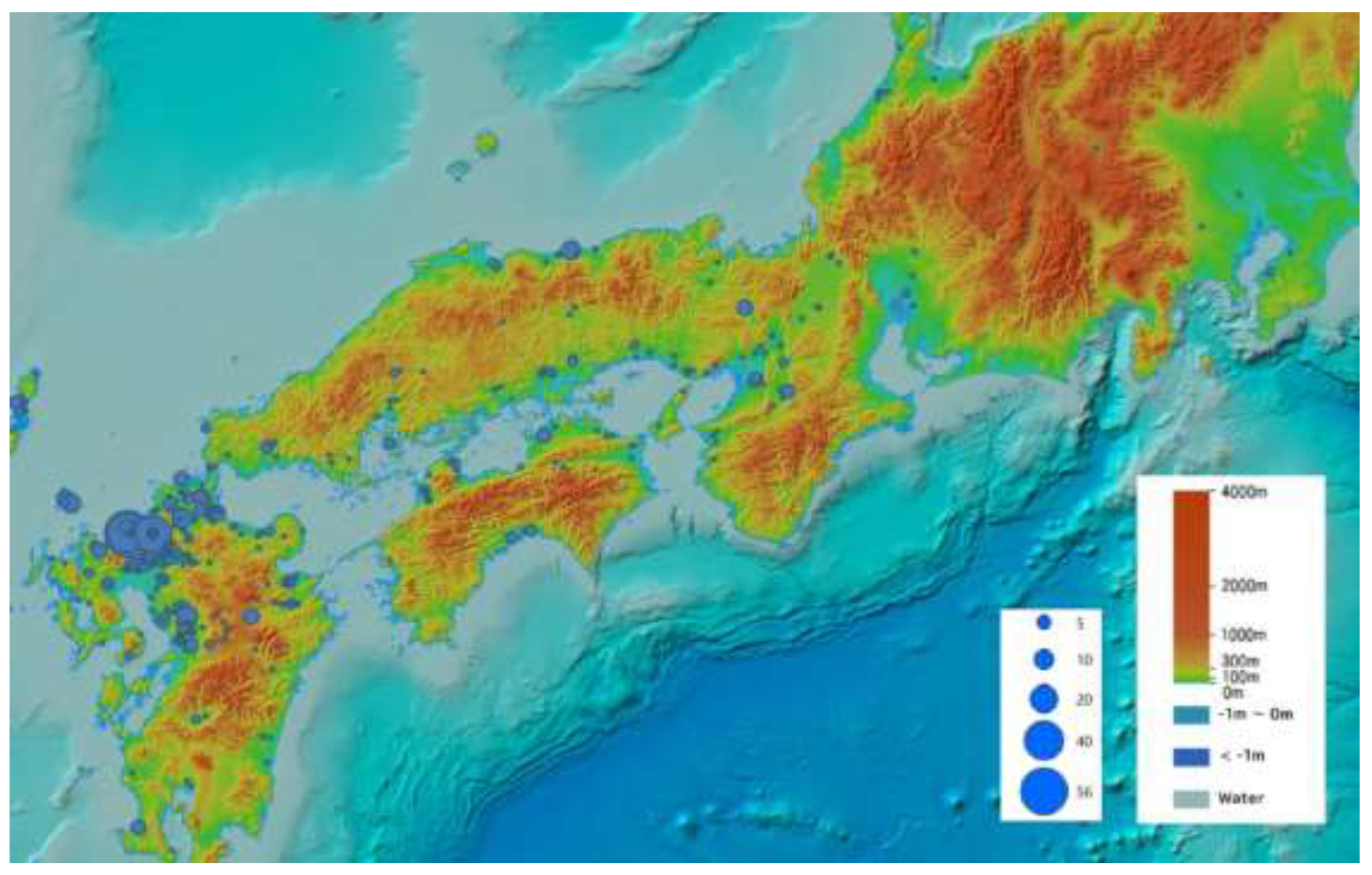
Figure 4.
Distribution of Yayoi-Period Iron Arrowheads. Note: The size of the circle reflects the number of artifacts excavated at the site.
Figure 4.
Distribution of Yayoi-Period Iron Arrowheads. Note: The size of the circle reflects the number of artifacts excavated at the site.
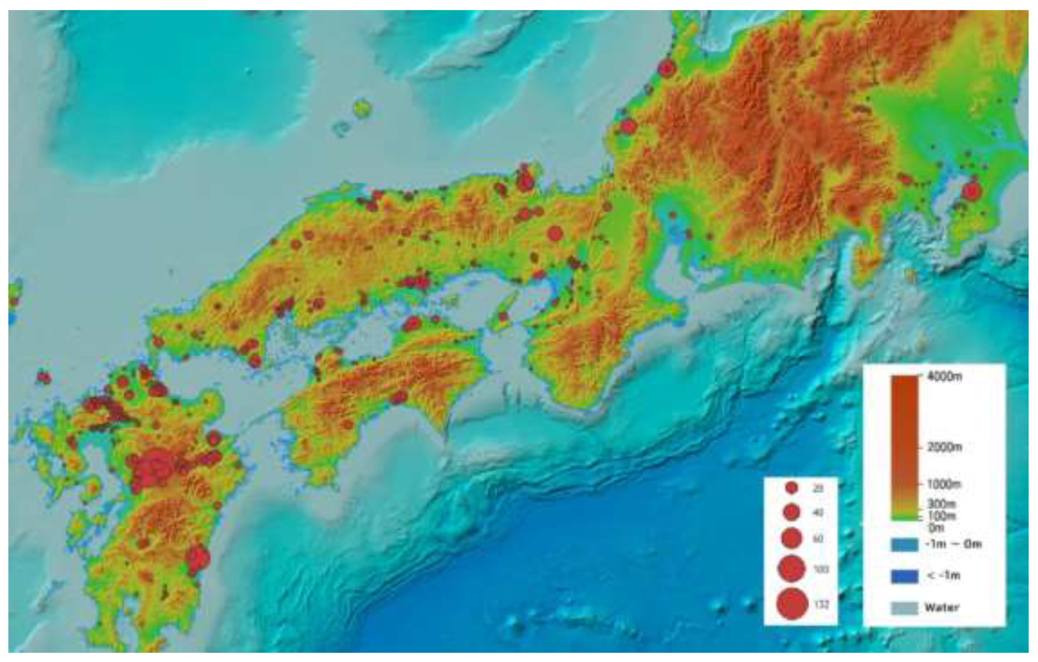
Figure 5.
Distribution of Yayoi-Period Iron Spears. Note: The size of the circle reflects the number of artifacts excavated at the site.
Figure 5.
Distribution of Yayoi-Period Iron Spears. Note: The size of the circle reflects the number of artifacts excavated at the site.
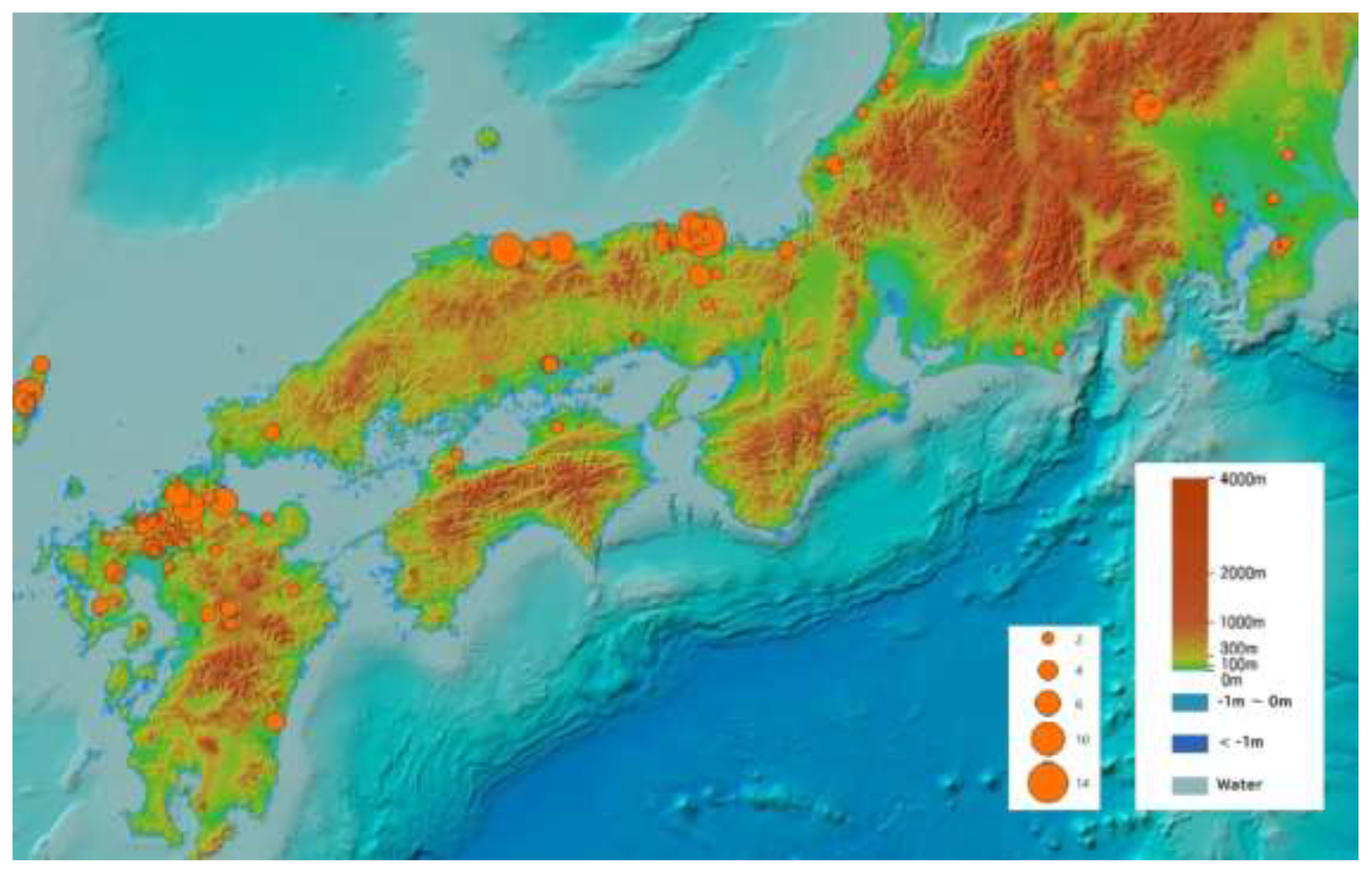
Figure 6.
Distribution of Yayoi-Period Silk Textiles.
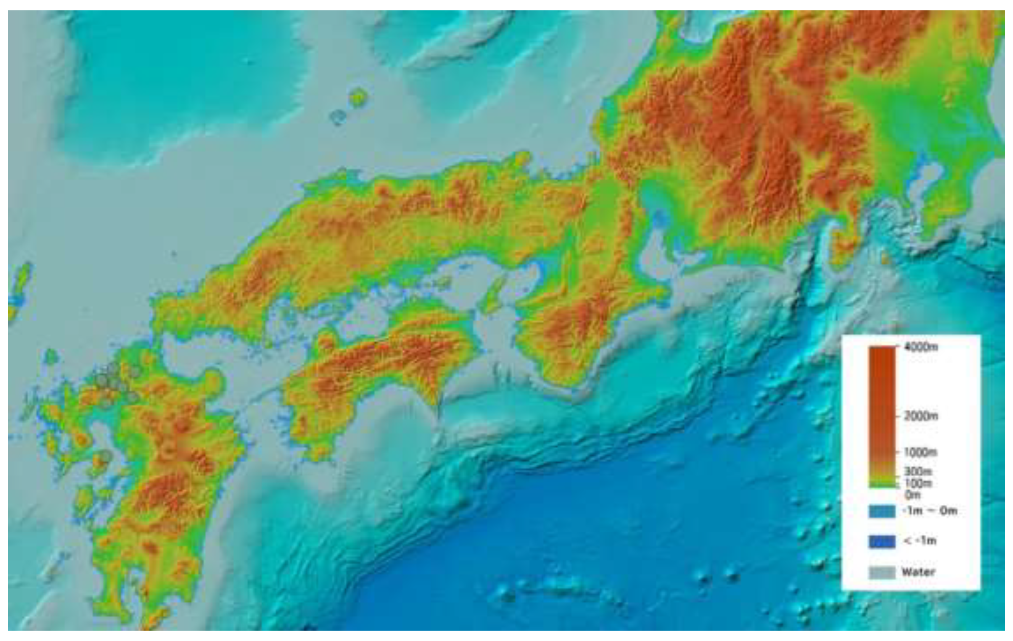
Figure 7.
Distribution of Yayoi-Period Bronze Bells. Note: The size of the circle reflects the size (mm) of the artifact.
Figure 7.
Distribution of Yayoi-Period Bronze Bells. Note: The size of the circle reflects the size (mm) of the artifact.
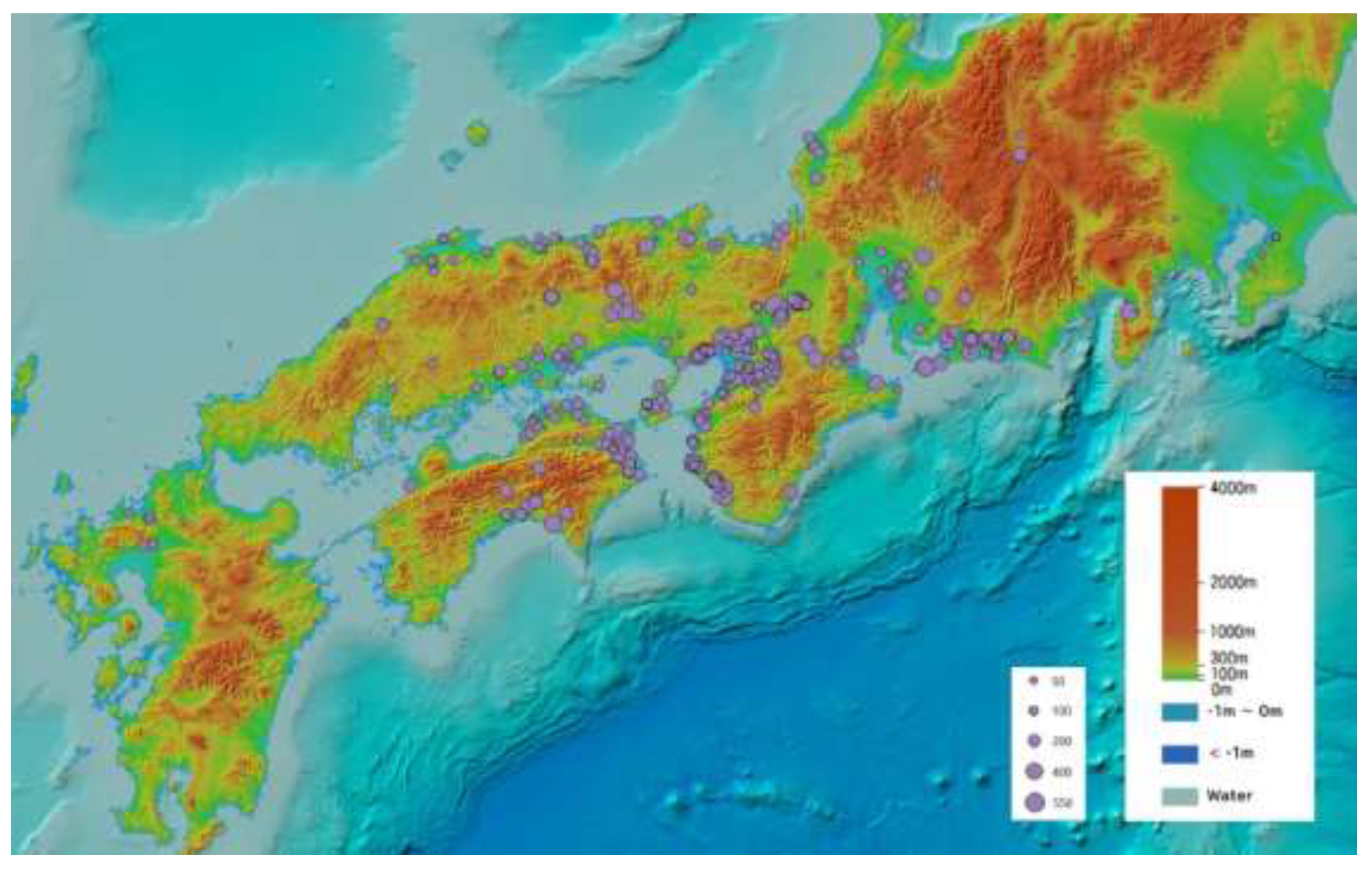
Figure 8.
Distribution of Yayoi-Period Iron Weapons in Osaka Bay and Yamato. Note: Enlarged view of Figure 4 and Figure 5 combined.
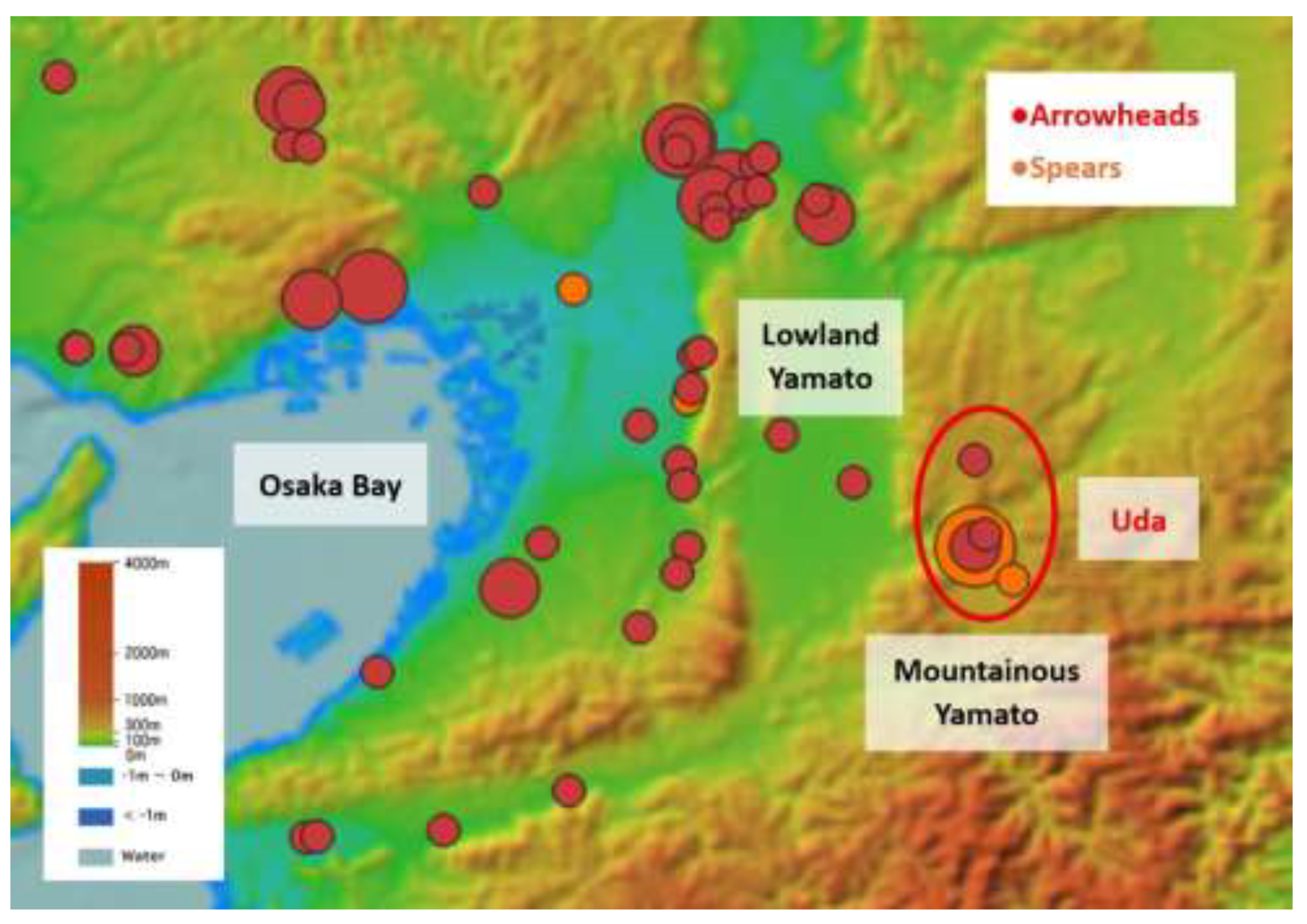
Figure 9.
Distribution of Yayoi-Period Iron Weapons. Note: Enlarged view of Figure 4 and Figure 5 combined.
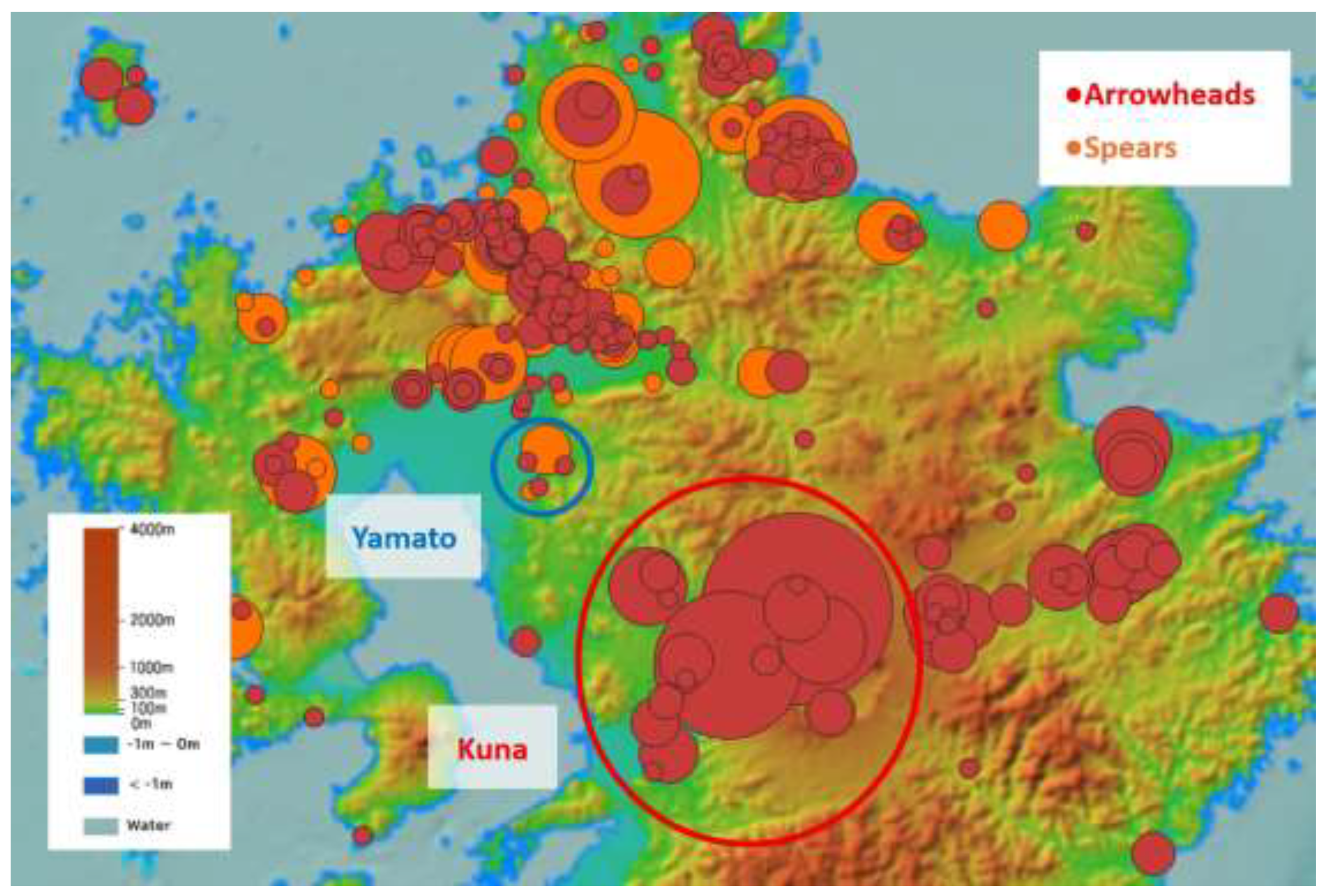
Figure 10.
Travel Routes Interpreted According to the Chunqiu Style of Numerical Representation.
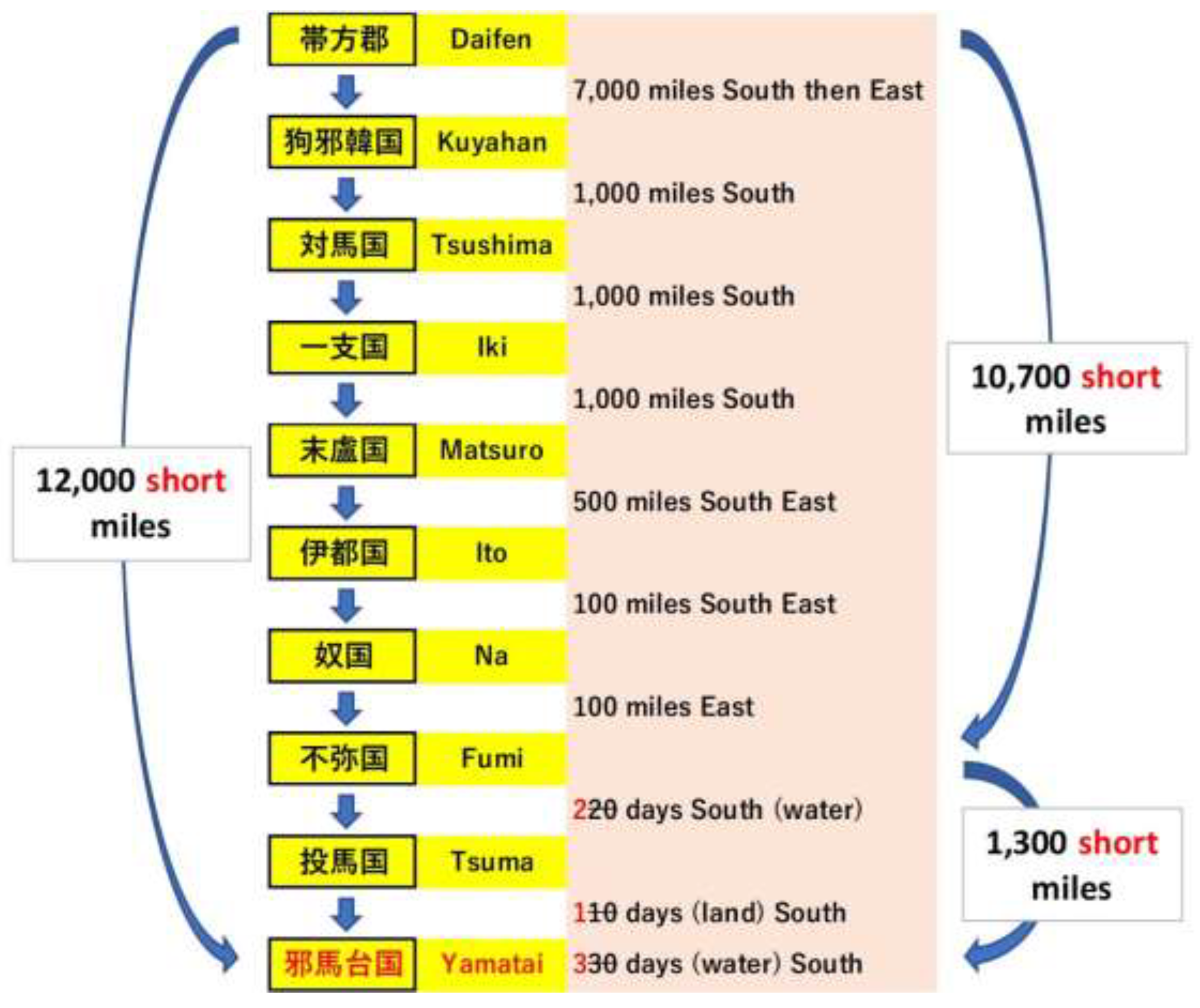
Figure 11.
Route from Fumi through Tsuma to Yamatai Queendom (Wei Zhi). Note: Enlarged view of Figure 3, Figure 4 and Figure 5 combined.
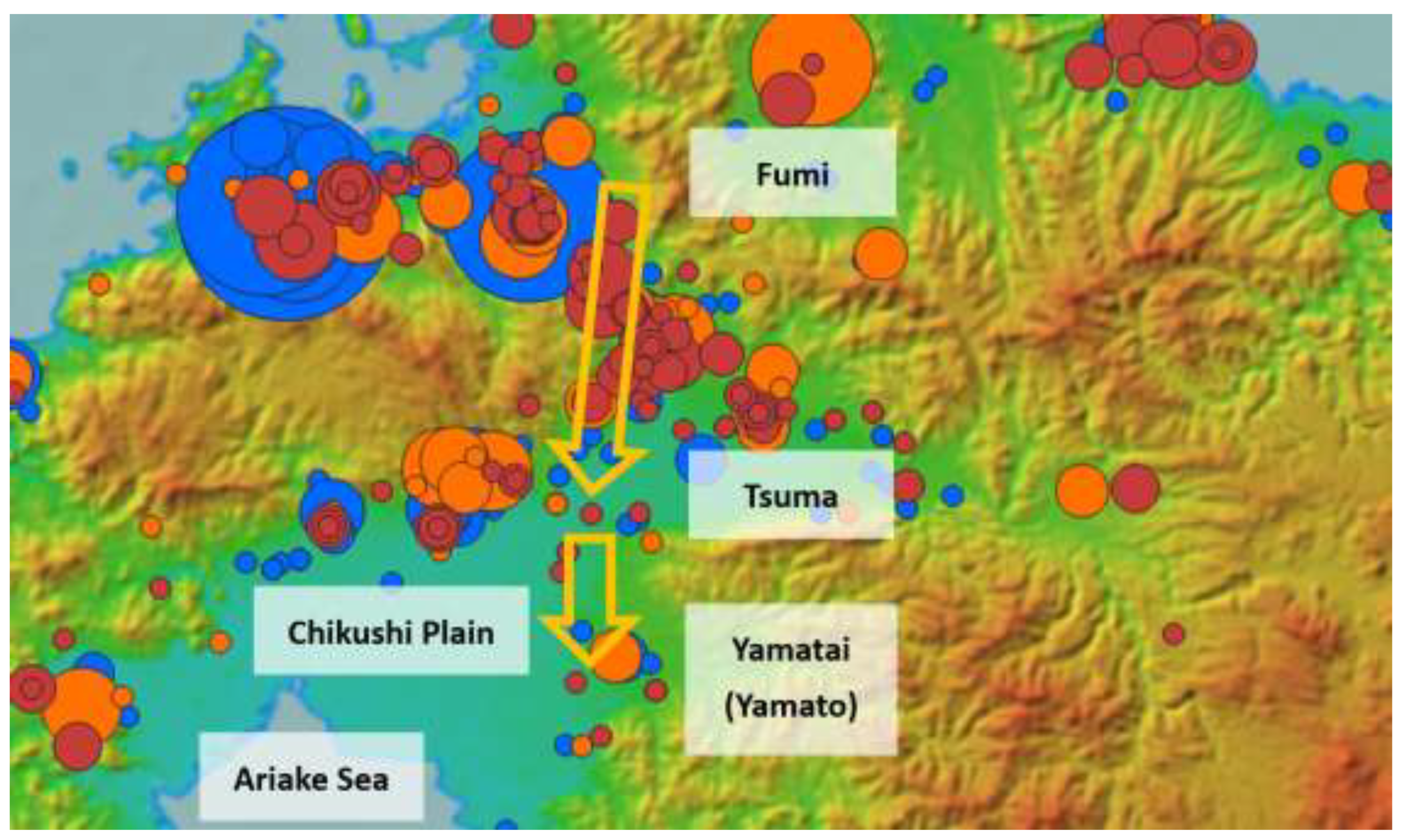
Figure 12.
Simulation for 10m Sea Level Rise of Northern Kyushu.
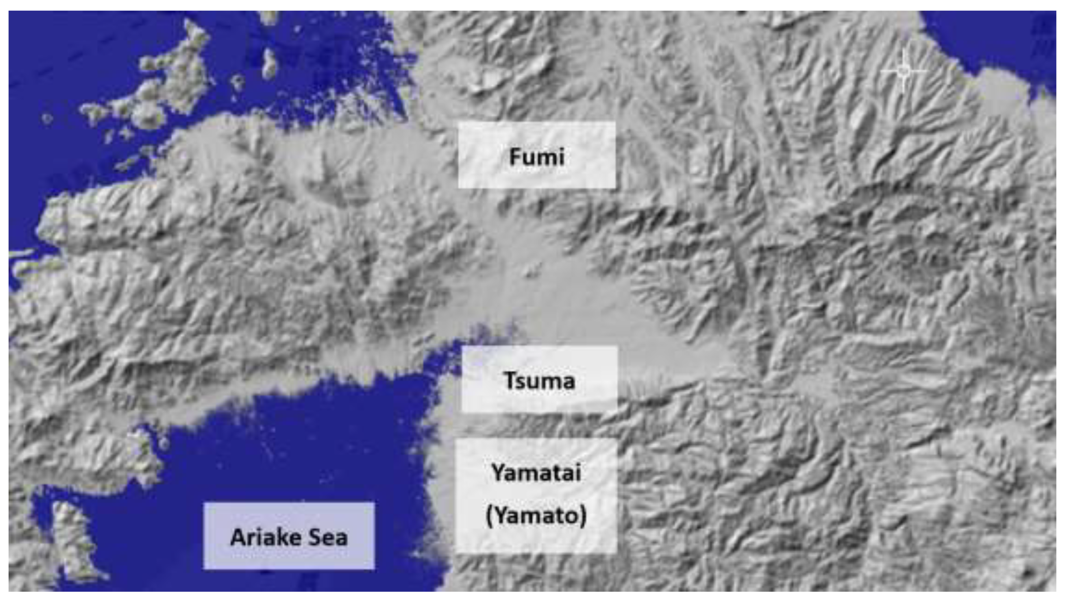
Figure 14.
Simulation for 10m Sea Level Rise of Osaka Bay.
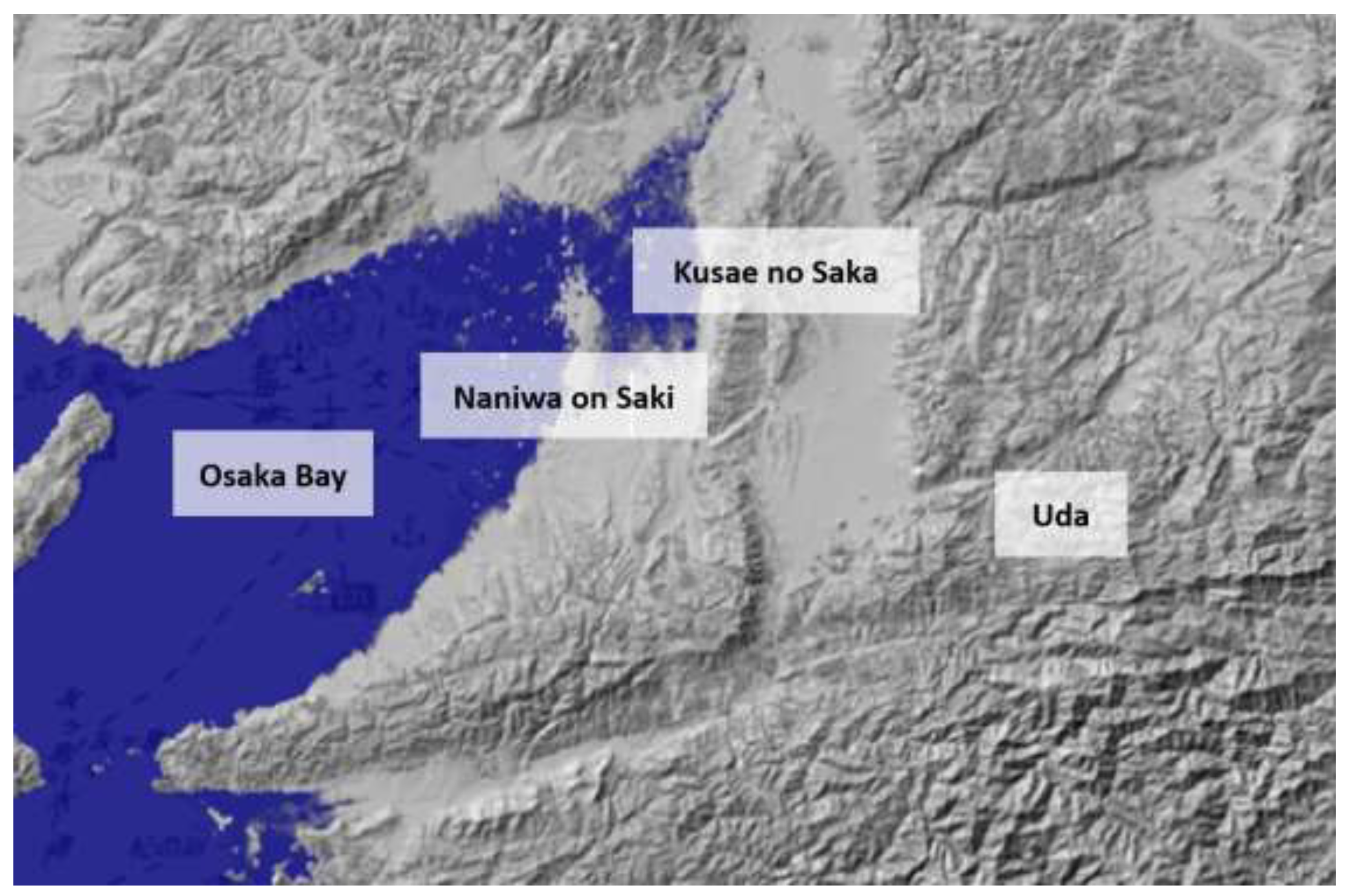

Table 1.
Overview of Yamatai Queendom (Wei Zhi).
| Item | Description |
|---|---|
| Period | Around the third century CE (from the Late Yayoi period to the Early Kofun period) |
| Major Events | Following the “Great Disturbance of Wa” in the latter half of the second century, internal conflict subsided when the various polities collectively enthroned Himiko as queen. |
| Diplomacy | In 238 or 239 CE, Himiko dispatched envoys to Wei, a major power on the Chinese mainland at the time, and received from the emperor the title “Queen of Wa, subject to Wei,” along with a golden royal seal and one hundred bronze mirrors, among other gifts. |
| Successor | After Himiko’s death, traditionally dated to around 247 CE, a male ruler was installed, but renewed internal strife ensued. Stability was restored when Toyo (Iyo), a 13-year-old female relative of Himiko, ascended the throne as queen. |
Table 2.
Numbers of Yayoi-Period Bronze Mirrors in Each Central Area.
| Location | Central Area | Sites | Bronze Mirrors |
|---|---|---|---|
| Kushu | Fukuoka Prefecture | 131 | 343 |
| Kinai | Nara Prefecture | 4 | 8 |
| Entire Japan | - | 425 | 789 |
Note: The numbers ignore sizes and include fragments.
Table 3.
Numbers of Yayoi-Period Iron Arrowheads in Each Central Area.
| Location | Central Area | Sites | Bronze Mirrors |
|---|---|---|---|
| Kushu | Fukuoka Prefecture | 106 | 352 |
| Kinai | Nara Prefecture | 4 | 4 |
| Entire Japan | - | 549 | 2,022 |
Table 4.
Numbers of Yayoi-Period Iron Spears in Each Central Area.
| Location | Central Area | Sites | Bronze Mirrors |
|---|---|---|---|
| Kushu | Fukuoka Prefecture | 52 | 99 |
| Kinai | Nara Prefecture | 1 | 1 |
| Entire Japan | - | 226 | 426 |
Table 5.
Numbers of Yayoi-Period Silk Textiles in Each Central Area.
| Location | Central Area | Sites |
|---|---|---|
| Kushu | Fukuoka Prefecture | 13 |
| Kinai | Nara Prefecture | 0 |
| Entire Japan | - | 14 |
Table 6.
Numbers of Yayoi-Period Bronze Bells in Each Central Area.
| Location | Central Area | Sites | Bronze Mirrors |
|---|---|---|---|
| Kushu | Fukuoka Prefecture | 3 | 4 |
| Kinai | Nara Prefecture | 15 | 18 |
| Entire Japan | - | 315 | 409 |
Table 7.
Numbers of Yayoi-Period Iron Weapons in Osaka Bay, Uda and Yamato.
| Location | Area | Arrowheads | Spears |
|---|---|---|---|
| Osaka Bay | Osaka Prefecture | 36 | 3 |
| Uda | Uda and Tsuge | 4 | 5 |
| Yamato outside Uda | Nara Prefecture (excl. Uda) | 2 | 0 |
Table 8.
Featured Areas and the Numbers of Excavated Iron Arrowheads and Bronze Mirrors.
| Area | Present Municipalities | Iron Arrow-heads (A) | Iron Spears (B) |
Bronze Mirrors (C) |
Military Ratio (A+B)/C |
Estimated Functions |
|---|---|---|---|---|---|---|
| Itoshima | Itosihama | 10 | 7 | 127 | 0.13 | Culture |
| Fukuoka | Fukuoka,Kasuga | 79 | 23 | 78 | 1.31 | Metropolis |
| Asakura | Asakura, Chikuzen, Ogori | 27 | 13 | 23 | 3.17 | Military |
|
Yamato (Kyushu) |
Miyama, Yame, Chikugo | 3 | 13 | 8 | 2.00 | Religion Military |
| Yoshinogari | Yoshinogari, Kanzaki | 13 | 13 | 33 | 0.79 | Paddy field |
| Miyako | Miyako, Yukihashi | 37 | 9 | 16 | 2.88 | Military Seaport |
Disclaimer/Publisher’s Note: The statements, opinions and data contained in all publications are solely those of the individual author(s) and contributor(s) and not of MDPI and/or the editor(s). MDPI and/or the editor(s) disclaim responsibility for any injury to people or property resulting from any ideas, methods, instructions or products referred to in the content. |
© 2026 by the authors. Licensee MDPI, Basel, Switzerland. This article is an open access article distributed under the terms and conditions of the Creative Commons Attribution (CC BY) license (http://creativecommons.org/licenses/by/4.0/).
Copyright: This open access article is published under a Creative Commons CC BY 4.0 license, which permit the free download, distribution, and reuse, provided that the author and preprint are cited in any reuse.


