
Submitted:
03 February 2026
Posted:
06 February 2026
You are already at the latest version
Abstract
In late November 2025, over 1,000 mm of precipitation fell within six days across North Sumatra, triggering widespread landslides and flooding in the West Block of the Batang Toru ecosystem, the main habitat area of the Critically Endangered Tapanuli orangutan (Pongo tapanuliensis), estimated to contain 581 individuals (95%CI [180–1,201]) prior to the event (Wich et al. 2019) though more recent assessments suggest further declines (Wich et al. 2023). Based on interpretation of pre- and post-event Sentinel-2 and PlanetScope imagery, we quantified the extent of forest loss. Using a validated, unbiased area estimation, we determined that 8,303 ± 1,760 ha of previously intact forest vanished in landslides and floods. These scar estimates were combined with a 1km² density surface from a 2016 survey to estimate the number of orangutans potentially affected. Our results indicate that approximately 58 individuals (range: 18–120, about 10% of the West Block population), have likely perished in landslides, tree falls, or flooding. Population viability models indicate that sustained additional annual mortality exceeding 1% (e.g., from hunting) drives extinction in suboptimal habitats; our preliminary estimate of an ~11% one-time mortality from this event, compounded by extensive habitat loss, thus represents a critical demographic shock equivalent to multiple years of such losses.We call upon the Indonesian government, the international community, and local land users to take immediate action and provide support to ensure the survival of the Tapanuli orangutan. The government is urged to enact emergency protections, halt habitat-damaging development, and expand protected areas including restoration of critical lowland forest, with essential financial and technical support from the global community.
Keywords:
climate change
; extreme rainfall
; landslides
; Pongo tapanuliensis
; species extinction
; tropical forest
1. Introduction
The Tapanuli orangutan (Pongo tapanuliensis) was only recognized as a distinct species in 2017 and is the great ape species with the smallest wild population (Nater et al. 2017). Estimates indicate that fewer than 800 individuals remain in three isolated populations within the Batang Toru forest area (West Block, East Block and South [Sibual-Buali] Block), all of which affected by habitat fragmentation and degradation (Laurance et al. 2020; Wich et al. 2019; Wich et al. 2016). Previous studies indicate that sustained additional population losses (death or removal) exceeding 1% annually will result in extinction (Marshall et al. 2009). The Tapanuli orangutan is currently estimated to occupy only 2.5–5% of its historical range, persisting mainly in mid- to high-elevation areas where hunting pressure, while not absent, has historically been relatively low, but where habitat conditions are sub-optimal for the species (Meijaard et al. 2021). The species’ survival depends on low mortality and near zero additional habitat loss (Wich and Meijaard 2021).
Between 23 and 28 November 2025, tropical cyclone Senyar unleashed unprecedented rainfall to large parts of Southeast Asia, resulting in floods and landslides that claimed nearly 1000 people and displaced millions in Sumatra (Muazam et al. 2025). One weather station in West Sumatra recorded 1003 mm of rain between 23 and 28 November (BMKG 2025). Even before the cyclone reached the area, Malaysia and Indonesia experienced persistent heavy rainfall that was intensified by Cyclonic Storm Senyar (named by the India Meteorological Department, IMD 2025). Senyar developed near the Strait of Malacca, where tropical cyclones seldom form due to its proximity to the equator and generally unfavorable conditions. The storm formed when bursts of cool continental air swept over the warm waters of the Malacca Strait, creating a shallow but coherent low-level circulation that allowed the cyclone to develop (Qing and Begum 2025). While not extremely intense in wind strength, Senyar generated widespread torrential rainfall, leading to severe flooding and landslides across Sumatra, Malaysia, and southern Thailand.
Despite more than a century of great ape research, there has been no prior quantification of how extreme rainfall events affect great apes (Kiribou et al. 2024), placing the present study in largely uncharted territory. Likewise, no studies have explicitly assessed the vulnerability of the Batang Toru forest structure to compound hazards such as landslides and flood scouring, although regional GIS-based analyses have identified parts of the wider Batang Toru landscape as susceptible to landslides (Hastuty and Ahmad 2024; Samsosir et al. 2025). Here, we provide the first quantitative evidence that a single extreme weather event may have severely impacted the Tapanuli orangutan. Unlike modeled catastrophes that assume no lasting reproductive impacts, this event’s habitat destruction likely reduced survivor fecundity through two pathways: 1) direct mortality and (2) through reduced food availability and increased energetic stress that lowers fecundity. We hereby focus on the first pathway by mapping pre-and post-event habitat extent in the Tapanuli orangutan’s largest remaining habitat, the Batang Toru West Block (“West Block” hereafter). We quantify structural forest damage caused by landslides and flooding. Next, we estimate the potential population-level impact using density surfaces from a predictive model and estimate the number of orangutans that might have died in landslides. Given the extensive impact of this event on the species and the potential impacts on its long-term survival, we provide evidence-based recommendations for preventing its extinction.
2. Materials and Methods
Study Area
We focused our analysis on the West Block of Tapanuli Orangutan habitat north of the Batang Toru River using the boundary of the resident (“Extant”) population from the IUCN Red List account for P. tapanuliensis (Wich et al. 2023). The study area covers 71,161 ha.
Remote Sensing Methods
We used four Sentinel-2 Level 2A images to determine land cover before and after the late November extreme weather event. These images were dated 27 October 2025 (pre-event image), 3 December 2025, 23 December 2025, and 26 December 2025. We cropped each image to the West Block of the Tapanuli Orangutan range. The analysis was aided by two PlanetScope 3 m resolution multispectral images dated 3 and 23 December 2025, which covered 18% and 95% of the study area respectively. This high-resolution imagery was provided courtesy of Mighty Earth and Planet.
The initial analysis published as a preprint used the 3 December Sentinel-2 image, which presented challenges as 36% of the study area was cloud covered. The current analysis used imagery with much lower cloud cover. The cloud cover for the 23 December image was 6.94%, and for 26 December was 9.26%. The final land cover classification was mainly based on the 23 December image as it was the most cloud-free. Areas covered by clouds on this image were filled in using either the Sentinel-2 imagery dated 3 or 26 December, or PlanetScope imagery which ever was cloud-free in that specific location. Although the 23 December PlanetScope imagery was higher spatial resolution than the Sentinel-2 for the same date, we did not receive the PlanetScope imagery until 4 January 2026. As the accuracy of the land cover classification based on the Sentinel-2 was high we deemed it unnecessary to re-run the classification using the PlanetScope imagery only. We, however, used the PlanetScope imagery as reference during the classification accuracy process. The image dated 27 October 2025 was selected as the best available pre-event image and contained 5.61% cloud cover.
We applied a Support Vector Machine (SVM) classification model (ESRI ArcGIS Pro) to distinguish between three land cover classes: forest, bare soil, and cloud or cloud shadow. We collected the training data by visually interpreting the Sentinel-2 images. Landslides are clearly visible in the 10 m true color composites due to the strong spectral contrast with surrounding forest. We generated two land cover maps using (1) the pre-event image and (2) the post-event image. For the post-event land cover, we then identified landslide and flood scouring scars as pixels that changed from the ‘forest’ class in the pre-event classification to the ‘bare soil’ class in the post-event classification. ‘Bare soil’ pixels classified as such in the pre- and post-event maps were labelled as ‘pre-event bare soil’. Thus, the resulting post-event land cover has four classes: forest, scar (post-event bare soil), pre-event bare soil, and cloud or cloud shadow.
We conducted an accuracy assessment on the pre- and post-event land cover classification result. Adhering to the good practice framework of Olofsson et al. (2014), we applied a stratified random sampling design to assess map accuracy, using the ESRI ArcGIS Pro Generate Random Sample tool. To ensure statistical rigour, we moved beyond simple pixel counting, instead using an error-adjusted estimator. This approach provided unbiased area estimates for forest loss and landslide scars, complete with 95% confidence intervals to quantify the precision of our results.
For the post-event land cover classification, 350 validation points were generated across the four target classes: clouds/shadows (n = 100), scars (n = 100), forest (n = 100), and pre-event bare soil (n = 50). We visually interpreted these sample points and assigned a reference (ground-truth) label based on multi-temporal Sentinel-2 imagery from 3, 23, and 26 December 2025, which was further supported by high-resolution (3 m) PlanetScope imagery acquired on 3 December 2025. To accurately interpret pre-event bare soil from landslide scars, we additionally visualized the pre-event Sentinel-2 imagery acquired on 27 October 2025. For the pre-event land cover classification a total of 300 validation points were generated across three target classes: clouds/haze (n = 100), forest (n = 100), and pre-event bare soil (n = 100). These sample points were visually interpreted and assigned reference (ground-truth) labels based on the pre-event Sentinel-2 imagery acquired on 27 October 2025.
We used the 3-meter resolution PlanetScope imagery to look in more detail at whether we could identify any visual edge effects around flood and landslide scars (e.g., fallen trees, broken canopy), but no such damage was visible. It seems that most of the landslides occurred in patches of up to a few to a hundred hectares where probably initial tree falls pulled down trees around creating a downslope domino effect. Such effects have been demonstrated following hurricanes in Mexican rainforest (Garrido-Pérez et al. 2008) and Panama (Putz 1984), for example, while half a billion trees were estimated to have died following a single squall line across the Amazon (Negrón-Juárez et al. 2010).
Population Impact Assessment
To estimate the number of orangutans affected by the rainfall-event, we used 1 x 1 km grid-cell orangutan density data that had been generated through a predictive model using environmental and human-impact variables, that included elevation, habitat conditions (forest cover, forest type, aboveground carbon), human pressure (population density, distance to roads), and climate (annual rainfall, rainfall variability, mean annual temperature, temperature range) (Wich et al. 2016). While this represents the most comprehensive available dataset, we acknowledge potential changes in distribution since 2016 due to ongoing threats (e.g., habitat fragmentation; Laurance et al. 2020). To each scar polygon we assigned the density of the corresponding grid cell in which the scar was located. We estimated the total number of orangutans directly affected by multiplying the scar area with density. The estimate has uncertainty from both the scar-area estimate (±1,760 ha, see below) and the density model estimate (95% CI: 180–1,201 individuals; Wich et al. 2016, 2019). Because the scar-area confidence interval is narrower (±21%) compared with the density-model uncertainty, we approximate the 95% CI on impacted orangutans by proportionally scaling the point estimate with the published total-population CI.
3. Results
Mapped Landslides and Flood Scouring Using Sentinel-2 and PlanetScope Imagery
The pre-event classification (Figure S1) showed that the study area was 99.3% forested, with 0.6% bare soil. Our land cover classification estimated 8,303 ± 1,760 ha of bare soil (flood damage and landslide scars, henceforth referred to as ‘scars’) which appeared after the storm (Figure 1). This accounted for 11.7 ± 2.4% of the total study area. Figure 2 shows the pre-event forest cover of a particularly badly affected part of the West Block.
The classification accuracy for the post-event land cover classification was high, with an overall accuracy of 97.6% (Table S1). The individual classes demonstrated strong performance, with user’s accuracies ranging from 95.0% for scars and 98.0% for forest, and producer’s accuracies ranging from 84.9% for scars and 99.3% for forest (Table S1). The estimated landslide area of 8,303 ± 1,760 ha is slightly above the mapped area (7,419 ha) because producer’s accuracy (85.0%) is lower than the user’s accuracy (95.0%). That is, the map omits slightly more landslides than it falsely includes (see Table S1 for details).
The classification accuracy assessment for the baseline (pre-event) land cover classification was high with an overall accuracy of 99.8% (Table S2). The forest class achieved a user’s accuracy of 100% and a producer’s accuracy of 99.8%, indicating nearly perfect alignment between the map and the reference data for this class. Other classes, including clouds/haze and pre-event bare soil, showed high reliability with user’s accuracies of 97.0% and 96.0%, respectively. The adjusted extent of forest cover prior to the extreme weather event was 66,833.4 ± 135 ha. For areas of cloud (5.61%) on the pre-event image we visually checked imagery from August 2025 and confirmed that all cloud on the pre-event image was forest. This provided an accurate baseline to measure forest loss attributed to the landslides.
Integrated Impact Layer and Number of Orangutans Affected
There were 50,185 visible scars, with a mean scar size of 0.15 ha and a maximum area of 95.7 ha. 1,054 scars exceeded 1 ha in area, and 57 scars exceeded 10 ha. At least in some areas, landslide scars appear to be drainage-controlled, following first- and second-order streams (Figure 2). In other areas, landslides occur in isolated areas not obviously related to streams. In all these scars, trees and scrubs vanished in landslides, and we expect there to be near-zero food resources for orangutans for at least 5 years until pioneer forest regrowth once again starts producing food for orangutans (Ardi 2023 ).
The overlay of the 1km² orangutan density surface (2016 dataset) with the scar areas resulted in an estimated 58 orangutans potentially directly impacted (range: 18–120, based on pre-event population CI). These animals were possibly killed during tree falls or landslides or drowned in flooded areas and flooded rivers. At least one orangutan death has been reported in the media (Khadka 2025), which appeared to be an animal that had drowned in a flood, with the corpse showing signs of severe abrasion. No field surveys have been possible so far to find evidence of dead or injured orangutans and other wildlife. The orangutan mortality estimate suggests that ~11% of the West Block population died or were injured during the 5 days of extreme rain.
4. Discussion
Extent and Characteristics of the Rainfall Event
Rainfall between 23 and 28 November 2025 varied from 103 mm in Padang Lawas Utara District to 661 mm in Central Tapanuli District and 1003 mm in West Sumatra Province, indicating spatial variability in rainfall (BMKG [Indonesia’s meteorology agency] rainfall data). There is one rainfall estimate from within the affected West Block of 564 mm, between 23 and 28 November, with two days of extreme (>150 mm) rainfall, 207 mm and 204 mm (Agincourt Resources 2025). More than 150 mm of rainfall per day is, even for tropical regions, rare and close to the 100-year return level in historical observations (Gründemann et al. 2022). Thus, multi-day totals approaching 1,000 mm exceed the upper envelope of historically observed extremes. Although a full extreme value analysis using local meteorological (“BMKG”) station data is pending, a 4–5 day accumulation of ~1,000 mm in northern Sumatra is very likely to correspond to at least a century-scale (≥100-year) event. Such an event will have become much more likely to occur in today’s climate, as heavy rainfall in the rainy season has been observed to increase in most mountainous regions (Pepin et al. 2022) and extreme events are expected to increase in intensity and likelihood, faster than the 7% expected from the Clausius-Clayperon relationship per degree of warming (Gründemann et al. 2022).
Rainfall intensity determines the severity of landslide and flood hazards in tropical mountain regions. In steep, deeply weathered landscapes such as Batang Toru, high-intensity precipitation rapidly increases pore-water pressure, destabilizing slopes and triggering widespread landslides, debris flows, and canopy structural failure (Hastuty and Ahmad 2024; Samsosir et al. 2025). Once rainfall surpasses a critical threshold, even intact old-growth forest cannot prevent slope collapse. Thus, the exceptional intensity of the late-November 2025 rainfall event largely explains the scale of habitat destruction observed across the Tapanuli orangutan’s core range.
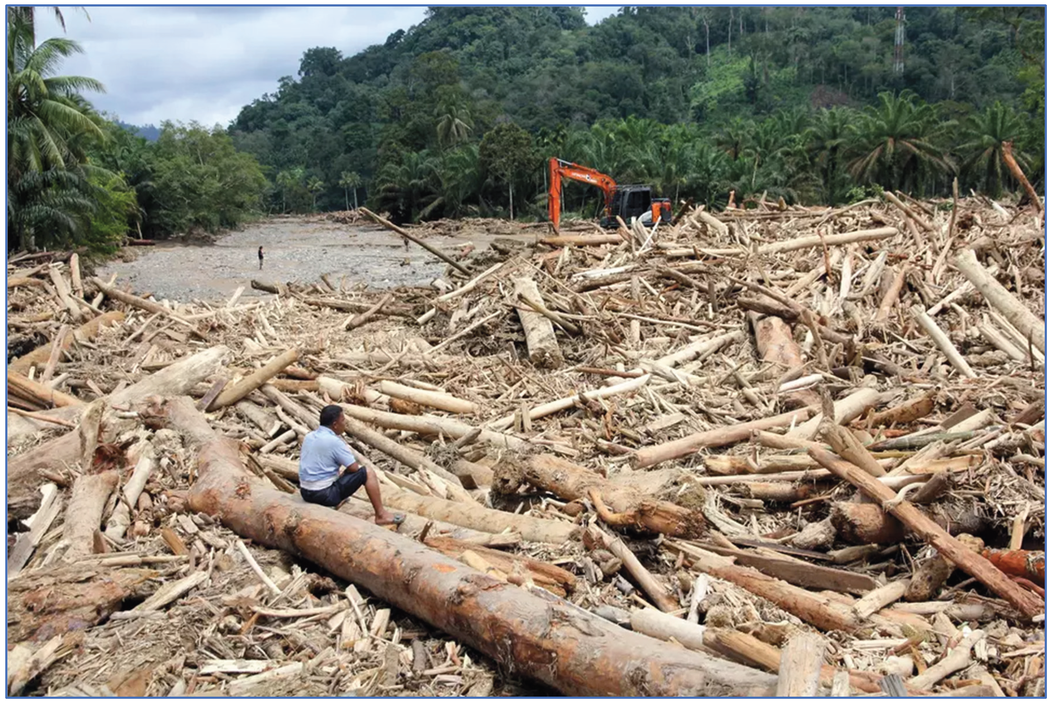
The 8,303 ± 1,760 ha of landslides in areas that consisted mostly of primary forest would have removed vast volumes of timber. Large woody debris is known to be a major cause in flooding events, as for example demonstrated in Costa Rica (Mao and Comiti 2010) and Thailand (De Graff et al. 2012), and especially where log jams occur at bridge sites (Okamoto et al. 2020). Logs can greatly increase the destructiveness of flooding events, as they can lead to local debris dams, which in steep terrain can suddenly collapse and cause violent flash floods. They can also add to the destructiveness of moving high flood waters. Floating logs act as battering rams and can build up huge crushing weights against built structures such as bridges. Above ground biomass in the West Block is around 198 tons per hectare (Pratiwi et al. 2024). If we assume 1.2 to 1.4 m3 of wood per ton of biomass, and a timber recruitment rate of 50%, this indicates that some 1.2 million m3 of timber slid into streams and rivers. Inspection of the post-event PlanetScope image did not show obvious log jams within the West Block area, indicating that much of this timber was flushed further down river, where it likely contributed to the severe flooding in lowland areas (Figure 3).
Biological Meaning of Losses
Great apes have low reproductive rates, and among them, orangutans have the lowest, with interbirth intervals of 6-9 years (Emery Thompson and Sabbi 2024; Wich et al. 2009). This, and the small size of the three isolated Tapanuli Orangutan populations, makes them highly sensitive to unpredictable habitat disruption. Population modelling on Sumatran orangutans (before the identification of the Tapanuli orangutan), using a 2% probability of catastrophic events (i.e., occurring on average once every 50 years), killing 20% of the local population, did not affect the reproduction of surviving individuals (Marshall et al. 2009). Those estimates were made assuming no ongoing reproductive suppression post-event; in contrast, the habitat degradation here is likely to displace survivors to lower-quality areas, further reducing interbirth intervals and overall viability. November’s deluge however, exceeds these modelling assumptions, with frequency of these events being likely much higher than once every 50 years, and structural damage to forest and displacement of individuals into ecologically lower quality habitats likely reducing reproductive outputs.
The only modern example of catastrophic great ape mortality comes from the Ebola outbreaks that devastated western gorilla and chimpanzee populations in Central Africa in the early 2000s, where mortality reached 80–95% in several monitored groups (Leroy et al. 2004). By comparison, we estimate that the late-November 2025 rainfall event in North Sumatra directly killed or injured which, when combined with habitat loss, may equate to the demographic equivalent of sustained >1% annual losses over several years. These numbers are inferred from our use of remote sensing data and one confirmed report (Khadka 2025); field surveys are urgently needed. Although proportional mortality is lower than that caused by Ebola, the demographic consequences for the Tapanuli orangutan could be more severe because so few individuals survive, and the entire species is confined to three isolated population fragments in a mountain landscape. Moreover, while Ebola leaves habitat intact, the Sumatra event caused landscape-scale forest degradation, compounding mortality with long-term loss of nesting, feeding, and dispersal resources. Even though the West Block population can likely withstand this event if there are no further losses, the risk is that the impact of this event, compounded with future habitat losses due to landcover change or another deluge, will put the species in a downward spiral towards extinction.
Significance of Structural Forest Damage
Detailed field surveys are needed to quantify impact on orangutan food availability via tree damage and fruit/flower loss. The 8,303 ± 1,760 ha of forest lost, concentrated around streams, likely eliminated key food sources. In Batang Toru, orangutan densities decrease with elevation (<300 m asl: 1.04 ind/km²; 300-800 m asl: 0.91 ind/km²; >800 m asl: 0.69 ind/km²; Wich et al. 2016). Damage patterns (Figure 1 and Figure 2) suggest displacement to higher-elevation, lower-capacity habitats or into adjacent agroforestry/agriculture, leading to farmer conflicts, injuries/deaths, or risky wild-to-wild translocations that could weaken remaining populations (Sherman et al. 2025; Sherman et al. 2022).
Extreme rainfall events negatively impact growth in Dipterocarp and several other species in Malaysian lowland forest (Margrove et al. 2015), with reduced growth in relation to extreme rainfall demonstrated over a 13-year period in 48% of tree species, while survival decreased in 92% of the species during periods of high rainfall (O’Brien et al. 2024). Orangutans do not normally feed on dipterocarp fruits, but the impact of excessive rain and waterlogged soils on tree growth and phenology likely applies to other tree families, and we expect that fruit and other orangutan food sources could currently be diminished in the West Block. It may take up to 200 years for forest on landslide areas to fully recover (Dislich and Huth 2012).
Landslide-driven forest damage increases locomotor costs and reduces food availability for orangutans, which are specialized for energy-efficient arboreal travel in continuous canopy. Canopy gaps force repeated vertical climbing, among the most metabolically expensive forms of primate locomotion, while disturbance also lowers fruit tree density and increases distances between food patches, pushing individuals toward negative energy balance (Halsey et al. 2016; Knott 1998; Vogel et al. 2011). Increased ground travel in structurally degraded forests further elevates energetic costs and risk (Spehar and Rayadin 2017). Because orangutans operate near minimal daily energy budgets, even small increases in movement costs can reduce feeding time, impair reproduction, and increase mortality (Vogel et al. 2011). Consequently, the extensive structural damage documented here likely imposes substantial energetic stress on surviving Tapanuli orangutans, compounding direct mortality with longer-term demographic impacts.
Climate Change Link
In a rapid attribution study, Kew et al. (2025) evaluated the inferred contribution of human-induced climate change to the event, alongside the effects of the prevailing La Niña conditions and the negative phase of the Indian Ocean Dipole (IOD), both of which are known to amplify heavy rainfall and increase the likelihood of such events. For the Strait of Malacca, they estimated that the current La Niña and negative IOD conditions contributed about 5% to 13% to the intensity of the observed rainfall. When estimating the role of human-induced climate change in the event, they first used a method based on statistical modelling and rainfall observations (van Oldenborgh et al. 2021), finding that despite relatively large discrepancies between different observation-based datasets, human-induced climate change has very likely increased both the intensity and likelihood of such deluges compared to a pre-industrial climate. For the Malacca Strait region, they estimated the increase in extreme rainfall associated with rising global mean temperatures at about 9% to 50% (Kew et al. 2025). This finding is in line with the scientific literature on the role of human-induced climate change on rainfall events in Indonesia.
Globally, an increase in both the frequency and intensity of heavy precipitation has been observed, with projections showing further increases by the end of the 21st century (Alexander and Arblaster 2017; Seneviratne et al. 2021). This increase has also been observed over Southeast Asia, (Singh and Qin 2020).
Projections of extreme rainfall in Indonesia (Kurniadi et al. 2024) show large spatial and seasonal variations but overall suggest an increase in wet extremes during the wet season, with the most extreme events surpassing records from the studied historical period of 1987-2014. The study further finds that in northern Sumatra, the wet season (December to February) is expected to become wetter and the dry season (June to August) drier. Breaking Indonesia into smaller regions, Marzuki et al. (2025) found rainfall increases in Central–Northern Sumatra are concentrated from November to February, coinciding with the peak monsoon season. These increases are also linked to enhanced moisture transport from the Indian Ocean and South China Sea.
Policy Implications
The November rainfall event underscored the acute vulnerability of the Tapanuli orangutan, a species for which even small increases in mortality or declines in habitat quality can have population-level consequences. Because its persistence hinges on low mortality and the maintenance of stable, high-quality forest, the extent of habitat damage documented here indicates that current safeguards are inadequate to ensure long-term viability.
The Government of Indonesia has taken an important step by temporarily halting major developments in the Batang Toru landscape, including mining, oil palm development and hydropower expansion (Wirayani 2025). This pause provides a rare opportunity to reassess ecological risks and reset development trajectories in light of the species’ extreme vulnerability. Consolidating this momentum will require converting the temporary halt into a structured review process that integrates updated climate-risk assessments, landslide susceptibility mapping, and new information about habitat carrying capacity following the storm. Strengthening and potentially expanding protection of lowland and riparian forests, improving conflict-mitigation capacity in areas where displaced orangutans may enter human-modified landscapes, and coordinating recovery through a dedicated government-led task force would help stabilize the population during the recovery period.
Given that the likelihood of extreme rainfall events of the kind witnessed in November 2025 is increasing due to climate change, the international community also bears responsibility for supporting Indonesia’s efforts. This includes mobilizing rapid biodiversity-recovery financing, supplying technical expertise to improve hazard forecasting and restoration planning, and ensuring that global climate-finance mechanisms recognize the losses experienced by highly range-restricted species such as the Tapanuli Orangutan. International partners can bolster Indonesia’s leadership by co-developing green development alternatives that reduce pressure on the Batang Toru ecosystem while providing local benefits.
To operationalize these recommendations,, we strongly recommend an immediate moratorium on land-use activities that degrade remaining habitat; expansion of protected areas around the West Block and key corridors; a detailed orangutan habitat and population assessment; restoration of lowland forests critical for long-term recovery; and urgent consideration of designation of the Batang Toru ecosystem as a National Strategic Area (Kawasan Strategis Nasional), which would provide a stronger legal basis for long-term protection, integrate conservation and disaster-risk management across jurisdictions, and ensure that national spatial planning prioritizes ecosystem integrity and climate resilience over extractive and infrastructure pressures. Civil society groups have underscored that the Batang Toru landscape functions not only as critical biodiversity habitat but also as a climate buffer and water source for millions of people, and that strategic national status would enhance coordination across ministries and strengthen oversight of land-use decisions that contribute to ecological degradation and hydrometeorological hazards (Manaf 2025; Wicaksono 2025).
The crisis facing the Tapanuli orangutan illustrates the convergence of climate instability and biodiversity loss, calling for a coordinated response that matches the scale of the threat. Indonesia’s immediate actions have created political space for decisive conservation measures, but sustained international support will be essential. Through a combination of strengthened domestic protection, climate-responsive planning, and global financial and technical assistance, it remains possible to prevent the first modern extinction of a great ape species and demonstrate a shared commitment to safeguarding irreplaceable biodiversity in a rapidly changing climate.
5. Conclusions
This event illustrates the growing threat that climate-driven extreme events pose to species already pushed to the brink of extinction by habitat loss. Without immediate intervention, the Tapanuli orangutan faces the imminent risk of becoming the first great ape species to go extinct in modern history. Urgent, collaborative action is essential to mitigate these risks and prevent extinction.
Supplementary Materials
The following supporting information can be downloaded at: Preprints.org.
Author Contributions
Conceptualization, E.M., D.G. and S.W.; methodology, M.W., SN., R.D., N.U. and A.D.; writing—original draft preparation, E.M., R.D., P.H., D.S., A.D., H.K., F.O..; writing—review and editing, D.S., J.S., E.A., S.W.; visualization, M.W., S.N..; supervision, E.M. All authors have read and agreed to the published version of the manuscript.
Funding
This research received no external funding.
Conflicts of Interest
The authors declare no conflict of interest.
References
- Agincourt Resources. Agincourt Resources’ Response to the Garoga Flood: Fast, Fact-Based Action. 2025. Available online: https://agincourtresources.com/2025/12/02/agincourt-resources-response-to-the-garoga-flood-fast-fact-based-action/?utm_source=chatgpt.com (accessed on 10 December 2025).
- Ahmad, I. Indonesia Still Rejects Foreign Aid as Sumatra Floods Death Toll Nears 1,000; Jakarta Globe, 2025. Available online: https://jakartaglobe.id/news/indonesia-still-rejects-foreign-aid-as-sumatra-floods-death-toll-nears-1000 (accessed on 2 February 2026).
- Alexander, L.V.; Arblaster, J.M. Historical and projected trends in temperature and precipitation extremes in Australia in observations and CMIP5. Weather and Climate Extremes 2017, 15, 34–56. [Google Scholar] [CrossRef]
- Ardi, R. Ekologi Suksesi Habitat Orangutan Sumatera di Hutan Dataran Rendah dan Hutan Rawa Gambut. MSc Dissertation, Universitas Sumatera Utara, Medan, 2023. [Google Scholar]
- BMKG. Stasiun Meteorology Sumatera Barat. Laporan Iklim Harian. 2025. Available online: https://dataonline.bmkg.go.id/data-harian.
- De Graff, J.V.; Sidle, R.C.; Ahmad, R.; Scatena, F.N. Recognizing the importance of tropical forests in limiting rainfall-induced debris flows. Environmental Earth Sciences 2012, 67, 1225–1235. [Google Scholar] [CrossRef]
- Dislich, C.; Huth, A. Modelling the impact of shallow landslides on forest structure in tropical montane forests. Ecological Modelling 2012, 239, 40–53. [Google Scholar] [CrossRef]
- Emery Thompson, M.; Sabbi, K. Burger, O., Lee, R., Sear, R., Eds.; Ch. 19. Evolutionary Demography of the Great Apes. In Human Evolutionary Demography; 2024; pp. 423–474. [Google Scholar]
- Garrido-Pérez, E.I.; Dupuy, J.M.; Durán-García, R.; Ucan-May, M.; Schnitzer, S.A.; Gerold, G. Effects of lianas and Hurricane Wilma on tree damage in the Yucatan Peninsula, Mexico. Journal of Tropical Ecology 2008, 24, 559–562. [Google Scholar] [CrossRef]
- Gründemann, G.J.; van de Giesen, N.; Brunner, L.; van der Ent, R. Rarest rainfall events will see the greatest relative increase in magnitude under future climate change. Communications Earth & Environment 2022, 3, 235. [Google Scholar] [CrossRef]
- Halsey, L.G.; Coward, S.R.L.; Thorpe, S.K.S. Bridging the gap: parkour athletes provide new insights into locomotion energetics of arboreal apes. Biology Letters 2016, 12. [Google Scholar] [CrossRef]
- Hastuty, I.P.; Ahmad, F. Hazarika, H., Haigh, S.K., Chaudhary, B., Murai, M., Manandhar, S., Eds.; Landslide Analysis Using Geographic Information System (GIS) in South Tapanuli Regency. In Geo-Sustainnovation for Resilient Society; Springer Nature Singapore, Singapore, 2024; pp. 297–307. [Google Scholar]
- IMD. The Well-Marked low-pressure area over Malaysia & adjoining Strait of Malacca intensified into depression over strait of Malacca; India Meteorological Department, 2025. Press release 25th November, 2025. Available online: https://internal.imd.gov.in/press_release/20251125_pr_4498.pdf (accessed on 11 December 2025).
- Kew, S.; Zachariah, M.; Barnes, C.; Rajapakse, L.; Basconcillo, J. Increasing heavy rainfall and extreme flood heights in a warming climate threaten densely populated regions across Sri Lanka and the Malacca Strait. 2025. [Google Scholar]
- Khadka, N.S. Fears grow that world’s rarest apes were swept away in Sumatran floods; BBC, 2025. Available online: https://www.bbc.com/news/articles/cj4q1l0ly7wo (accessed on 12 December 2025).
- Kiribou, R.; Tehoda, P.; Chukwu, O.; Bempah, G.; Kühl, H.S.; Ferreira, J.; Sop, T.; Carvalho, J.; Mengel, M.; Kulik, L.; Samedi Mucyo, J.P.; van der Hoek, Y.; Heinicke, S. Exposure of African ape sites to climate change impacts. PLOS Climate 2024, 3, e0000345. [Google Scholar] [CrossRef]
- Knott, C. Changes in Orangutan Caloric Intake, Energy Balance, and Ketones in Response to Fluctuating Fruit Availability. International Journal of Primatology 1998, 19, 1061–1079. [Google Scholar] [CrossRef]
- Kurniadi, A.; Weller, E.; Salmond, J.; Aldrian, E. Future projections of extreme rainfall events in Indonesia. International Journal of Climatology 2024, 44, 160–182. [Google Scholar] [CrossRef]
- Laurance, W.F.; Wich, S.A.; Onrizal, O.; Fredriksson, G.; Usher, G.; Santika, T.; Byler, D.; Mittermeier, R.; Kormos, R.; Williamson, E.A.; Meijaard, E. Tapanuli orangutan endangered by Sumatran hydropower scheme. Nature Ecology & Evolution 2020, 4, 1438–1439. [Google Scholar] [CrossRef]
- Leroy, E.M.; Rouquet, P.; Formenty, P.; Souquière, S.; Kilbourne, A.; Froment, J.-M.; Bermejo, M.; Smit, S.; Karesh, W.; Swanepoel, R.; Zaki, S.R.; Rollin, P.E. Multiple Ebola Virus Transmission Events and Rapid Decline of Central African Wildlife. Science 2004, 303, 387–390. [Google Scholar] [CrossRef] [PubMed]
- Manaf, A. Green Justice Desak Pemerintah Tetapkan Ekosistem Batang Toru Jadi Kawasan Strategis Nasional;RMol Sumut. 2025. Available online: https://www.rmolsumut.id/green-justice-desak-pemerintah-tetapkan-ekosistem-batang-toru-jadi-kawasan-strategis-nasional (accessed on 9 December 2025).
- Mao, L.; Comiti, F. The effects of large wood elements during an extreme flood in a small tropical basin of Costa Rica. WIT Transactions on Engineering Sciences 2010, 67, 225–236. [Google Scholar]
- Margrove, J.A.; Burslem, D.F.R.P.; Ghazoul, J.; Khoo, E.; Kettle, C.J.; Maycock, C.R. Impacts of an Extreme Precipitation Event on Dipterocarp Mortality and Habitat Filtering in a Bornean Tropical Rain Forest. Biotropica 2015, 47, 66–76. [Google Scholar] [CrossRef]
- Marshall, A.J.; Lacy, R.; Ancrenaz, M.; Byers, O.; Husson, S.; Leighton, M.; Meijaard, E.; Rosen, N.; Singleton, I.; Stephens, S.; Traylor-Holzer, K.; Atmoko, S.U.; van Schaik, C.P.; Wich, S.A. Wich, S., Atmoko, S.U., Mitra Setia, T., van Schaik, C.P., Eds.; Orangutan population biology, life history, and conservation. Perspectives from population viability analysis models. In Orangutans: geographic variation in behavioral ecology and conservation; Oxford University Press; Oxford, UK, 2009; pp. 311–326. [Google Scholar]
- Marzuki, M.; Ramadhan, R.; Yusnaini, H.; Vonnisa, M.; Muharsyah, R.; Nugraha, Y.; Sari, A.Y.; Erajalita, A. Long-Term Spatial–Temporal Variability, Trends and Extreme Rainfall Events Over Indonesia Based on 43 Years of CHIRPS Data. International Journal of Climatology 2025, 45, e70107. [Google Scholar] [CrossRef]
- Meijaard, E.; Ni’matullah, S.; Dennis, R.; Sherman, J.; Onrizal; Wich, S.A. The historical range and drivers of decline of the Tapanuli orangutan. PLOS ONE 2021, 16, e0238087. [Google Scholar] [CrossRef]
- Muazam, A.R.; Karokaro, A.S.; Wijaya, T. Death toll rises in Sumatra flood catastrophe as gov’t moves to protect Batang Toru forest; Mongabay, 2025. Available online: https://news.mongabay.com/2025/12/death-toll-rises-in-sumatra-flood-catastrophe-as-govt-moves-to-protect-batang-toru-forest/ (accessed on 9 December 2025).
- Nater, A.; Mattle-Greminger, M.P.; Nurcahyo, A.; Nowak, M.G.; de Manuel, M.; Desai, T.; Groves, C.; Pybus, M.; Sonay, T.B.; Roos, C.; Lameira, A.R.; Wich, S.A.; Askew, J.; Davila-Ross, M.; Fredriksson, G.; de Valles, G.; Casals, F.; Prado-Martinez, J.; Goossens, B.; Verschoor, E.J.; Warren, K.S.; Singleton, I.; Marques, D.A.; Pamungkas, J.; Perwitasari-Farajallah, D.; Rianti, P.; Tuuga, A.; Gut, I.G.; Gut, M.; Orozco-terWengel, P.; van Schaik, C.P.; Bertranpetit, J.; Anisimova, M.; Scally, A.; Marques-Bonet, T.; Meijaard, E.; Krützen, M. Morphometric, Behavioral, and Genomic Evidence for a New Orangutan Species. Current Biology 2017, 27, 3487–3498.e3410. [Google Scholar] [CrossRef]
- Negrón-Juárez, R.I.; Chambers, J.Q.; Guimaraes, G.; Zeng, H.; Raupp, C.F.M.; Marra, D.M.; Ribeiro, G.H.P.M.; Saatchi, S.S.; Nelson, B.W.; Higuchi, N. Widespread Amazon forest tree mortality from a single cross-basin squall line event. Geophysical Research Letters 2010, 37. [Google Scholar] [CrossRef]
- O’Brien, M.J.; Hector, A.; Ong, R.; Philipson, C.D. Tree growth and survival are more sensitive to high rainfall than drought in an aseasonal forest in Malaysia. Communications Earth & Environment 2024, 5, 179. [Google Scholar] [CrossRef]
- Okamoto, T.; Takebayashi, H.; Sanjou, M.; Suzuki, R.; Toda, K. Log jam formation at bridges and the effect on floodplain flow: A flume experiment. Journal of Flood Risk Management 2020, 13, e12562. [Google Scholar] [CrossRef]
- Olofsson, P.; Foody, G.M.; Herold, M.; Stehman, S.V.; Woodcock, C.E.; Wulder, M.A. Good practices for estimating area and assessing accuracy of land change. Remote Sensing of Environment 2014, 148, 42–57. [Google Scholar] [CrossRef]
- Pepin, N.C.; Arnone, E.; Gobiet, A.; Haslinger, K.; Kotlarski, S.; Notarnicola, C.; Palazzi, E.; Seibert, P.; Serafin, S.; Schöner, W.; Terzago, S.; Thornton, J.M.; Vuille, M.; Adler, C. Climate Changes and Their Elevational Patterns in the Mountains of the World. Reviews of Geophysics 2022, 60, e2020RG000730. [Google Scholar] [CrossRef]
- Pratiwi, S.; Pasaribu, N.; Siregar, J.P. Structure, Composition, Carbon Stocks of Dipterocarpaceaein West Batang Toru Forest Block, North Tapanuli Regency, North Sumatra. Journal of Sylva Indonesiana 2024, 7, 22–29. [Google Scholar] [CrossRef]
- Putz, F.E. The natural history of lianas on Barro Colorado Island, Panama. Ecology 1984, 65, 1713–1724. [Google Scholar] [CrossRef]
- Qing, A.; Begum, S. Cyclone Senyar was rare for Southeast Asia – could a storm like it ever hit Singapore?;The Strait Times. 2025. Available online: https://asianews.network/cyclone-senyar-was-rare-for-southeast-asia-could-a-storm-like-it-ever-hit-singapore/ (accessed on 11 December 2025).
- Samsosir, A.G.M.B.; Sutisna, S.; Prakoso, L.Y.; Wilopo, W. Analysis of Landslide Disaster Vulnerability in North Tapanuli Regency Using a Grid-Based Geographic Information System Approach. East Asian Journal of Multidisciplinart Research 2025, 4, 4485–4498. [Google Scholar] [CrossRef]
- Seneviratne, S.I.; Zhang, X.; Adnan, M.; Badi, W.; Dereczynski, C.; Di Luca, A.; Ghosh, S.; Iskandar, I.; Kossin, J.; Lewis, S.; Otto, F.; Pinto, I.; Satoh, M.; Vicente-Serrano, S.M.; Wehner, M.; Zhou, B. Masson-Delmotte, V., Zhai, P., Pirani, A., Connors, S.L., Péan, C., Berger, S., Caud, N., Chen, Y., Goldfarb, L., Gomis, M.I., Huang, M., Leitzell, K., Lonnoy, E., Matthews, J.B.R., Maycock, T.K., Waterfield, T., Yelekçi, O., Yu, R., Zhou, B., Eds.; Weather and Climate Extreme Events in a Changing Climate., In Climate Change 2021: The Physical Science Basis. Contribution of Working Group I to the Sixth Assessment Report of the Intergovernmental Panel on Climate Change; Cambridge University Press; Cambridge, United Kingdom and New York, NY, USA, 2021; pp. 1513–1766. [Google Scholar]
- Sherman, J.; Voigt, M.; Ancrenaz, M.; Meijaard, E.; Oram, F.; Williamson, E.A.; Russon, A.E.; Seaman, D.J.I.; Caurant, C.; Byler, D.; Wich, S.A. Outcomes of orangutan wild-to-wild translocations reveal conservation and welfare risks. PLOS ONE 2025, 20. [Google Scholar] [CrossRef]
- Sherman, J.; Voigt, M.; Ancrenaz, M.; Wich, S.A.; Qomariah, I.N.; Lyman, E.; Massingham, E.; Meijaard, E. Orangutan killing and trade in Indonesia: Wildlife crime, enforcement, and deterrence patterns. Biological Conservation 2022, 276, 109744. [Google Scholar] [CrossRef]
- Singh, V.; Qin, X. Study of rainfall variabilities in Southeast Asia using long-term gridded rainfall and its substantiation through global climate indices. Journal of Hydrology 2020, 585, 124320. [Google Scholar] [CrossRef]
- Spehar, S.N.; Rayadin, Y. Habitat use of Bornean Orangutans (Pongo pygmaeus morio) in an Industrial Forestry Plantation in East Kalimantan, Indonesia. International Journal of Primatology 2017, 1–27. [Google Scholar] [CrossRef]
- van Oldenborgh, G.J.; van der Wiel, K.; Kew, S.; Philip, S.; Otto, F.; Vautard, R.; King, A.; Lott, F.; Arrighi, J.; Singh, R.; van Aalst, M. Pathways and pitfalls in extreme event attribution. Climatic Change 2021, 166, 13. [Google Scholar] [CrossRef]
- Vogel, E.R.; Knott, C.D.; Crowley, B.E.; Blakely, M.D.; Larsen, M.D.; Dominy, N.J. Bornean orangutans on the brink of protein bankruptcy. Biology Letters 2011, 8, 333–336. [Google Scholar] [CrossRef]
- Wicaksono, R.A. Ekosistem Batang Toru Diminta Jadi Kawasan Strategis Nasional;Betahita. 2025. Available online: https://betahita.id/news/detail/11641/ekosistem-batang-toru-diminta-jadi-kawasan-strategis-nasional.html?v=1765508098 (accessed on 10 December 2025).
- Wich, S.; Meijaard, E. Saving the Tapanuli orangutan requires zero losses. Oryx 2021, 55, 10–11. [Google Scholar] [CrossRef]
- Wich, S.A.; Atmoko, S.U.; Setia, T.M.; van Schaik, C. Orangutans. Geographic variation in behavioral ecology and conservation; Oxford University Press; Oxford, UK, 2009. [Google Scholar]
- Wich, S.A.; Fredriksson, G.; Usher, G.; Kuhl, H.; Nowak, M. The Tapanuli orangutan: Status, threats and steps for improved conservation. Conservation Science and Practice 2019, e33. [Google Scholar] [CrossRef]
- Wich, S.A.; Ni’Matullah, S.; Sherman, J.; Meijaard, E. Spatial data for P. tapanuliensis Red Listing. Borneo Futures, Brunei Darussalam 2023. Pongo tapanuliensis. The IUCN Red List of Threatened Species, 2023.
- Wich, S.A.; Singleton, I.; Nowak, M.G.; Utami Atmoko, S.S.; Nisam, G.; Arif, S.M.; Putra, R.H.; Ardi, R.; Fredriksson, G.; Usher, G.; Gaveau, D.L.A.; Kühl, H.S. Land-cover changes predict steep declines for the Sumatran orangutan (Pongo abelii). Science Advances 2016, 2, e1500789. [Google Scholar] [CrossRef]
- Wirayani, P. Indonesia Halts Agincourt, PTPN III Operations After Floods; Bloomberg, 2025. Available online: https://www.bloomberg.com/news/articles/2025-12-06/indonesia-halts-agincourt-ptpn-iii-operations-after-floods (accessed on 6 December 2025).
Figure 1.
Map of landslide scars. The delineated area is the boundary of the West Block Tapanuli Orangutan population (Wich et al. 2023). Base map data derived from the Esri Topographic Map Service (Source: Esri, TomTom, Garmin, FAO, NOAA, USGS, ©OpenStreetMap contributors, and the GIS User Community).
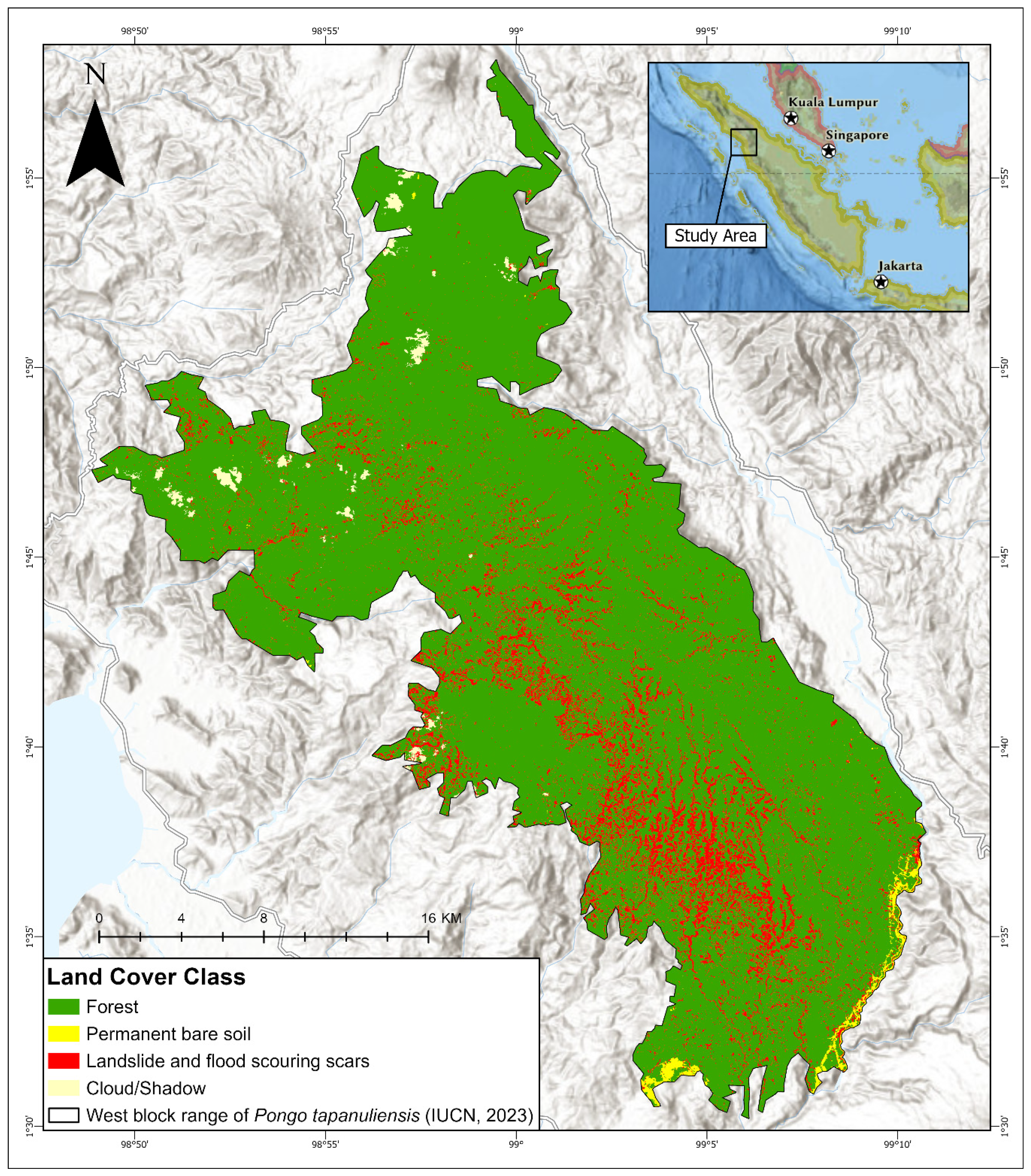
Figure 2.
Pre- and post-event imagery. 2A) Sentinel-2 image dated 27 October 2025 showing full forest cover. 2B) Sentinel-2 image of the same area dated 26 December 2025 showing extent of scars (cream colour), clouds and remaining forest. Image: Copernicus Sentinel data 2025; Base map data derived from the Esri Topographic Map Service (Source: Esri, TomTom, Garmin, FAO, NOAA, USGS, ©OpenStreetMap contributors, and the GIS User Community).
Figure 3.
Logjam in the Garoga River, 29 November 2025 (Antara Photo/Yudi Manar) (Ahmad 2025).
Disclaimer/Publisher’s Note: The statements, opinions and data contained in all publications are solely those of the individual author(s) and contributor(s) and not of MDPI and/or the editor(s). MDPI and/or the editor(s) disclaim responsibility for any injury to people or property resulting from any ideas, methods, instructions or products referred to in the content. |
© 2026 by the authors. Licensee MDPI, Basel, Switzerland. This article is an open access article distributed under the terms and conditions of the Creative Commons Attribution (CC BY) license.
Copyright: This open access article is published under a Creative Commons CC BY 4.0 license, which permit the free download, distribution, and reuse, provided that the author and preprint are cited in any reuse.


