
Submitted:
12 December 2025
Posted:
15 December 2025
You are already at the latest version
Abstract
In late November 2025, over 1,000 mm of precipitation fell within four days across North Sumatra, triggering widespread landslides and flooding in the West Block of the Batang Toru ecosystem, the core habitat of the critically endangered Tapanuli orangutan (Pongo tapanuliensis), estimated to contain 581 individuals (95%CI [180–1,201]) prior to the event [1]. Using pre- and post-event Sentinel-2 and PlanetScope satellite imagery, we quantified the extent of forest loss. Initial analysis indicates that 3,964 hectares of previously intact forest were swept away by landslides and floods. An additional 2,487 ha of scars is extrapolated from areas that are cloud-covered in the Sentinel-2 image. These scar estimates were combined with a 1km² density surface from a 2016 survey to estimate the number of orangutans potentially affected. Our results indicate that 33-54 individuals may have been impacted, with a substantial proportion likely killed by landslides, treefall, or flooding. Given that annual mortality exceeding 1% is sufficient to drive this species to extinction, our preliminary estimate of 6.2-10.5% mortality suggests a critical demographic shock. We call upon the Indonesian government and the international community to take immediate action and provide support to ensure the survival of the Tapanuli orangutan. The government is urged to enact emergency protections, halt habitat-damaging development, and expand protected areas to restore critical lowland forest, with essential financial and technical support from the global community.
Keywords:
climate change
; extreme rainfall
; landslides
; Pongo tapanuliensis
; species extinction
; tropical forest
1. Introduction
The Tapanuli orangutan was only recognized as a distinct species in 2017 and is the great ape species with the smallest wild population [2]. Estimates indicate that fewer than 800 individuals remain in three isolated populations within the Batang Toru forest area (West Block, East Block and South [Sibual-Buali] Block) that are affected by habitat fragmentation and degradation [3,4]. Previous studies indicate that sustained population losses (death or removal) exceeding an annual rate of 1% will result in extinction [5]. The current distribution of the Tapanuli orangutan is thought to be 2.5-5% of the historic range, remaining only in medium to high elevation areas where hunting pressure, though not zero, has been historically low, but where habitat conditions for the species are sub-optimal [6]. Species survival depends on very low mortality and zero habitat loss [7].
Between 23 and 28 November 2025, tropical cyclone Senyar brought unprecedented rainfall to large parts of Southeast Asia, resulting in floods and landslides that killed nearly 1000 people and displaced millions in Sumatra alone [8]. One weather station in West Sumatra recorded 1003 mm of rain between 23 and 28 November [9]. Even before the cyclone reached the area, Malaysia and Indonesia experienced persistent heavy rainfall that was intensified by Cyclonic Storm Senyar [10], which developed near the Strait of Malacca, a tropical basin that very rarely sees the development of tropical cyclones. Senyar formed when bursts of cool continental air swept over the warm waters of the Malacca Strait, creating a shallow but coherent low-level circulation that allowed the rare equatorial cyclone to develop [11]. While not extremely intense in wind strength, Senyar generated widespread torrential rainfall, leading to severe flooding and landslides across Sumatra, Malaysia, and southern Thailand.
Despite a century of great ape research, there is no prior quantification of how extreme rainfall events affect great apes [12], and the current study occurs in unknown territory. There have also not been any assessments of the vulnerability of the Batang Toru forest structure that compound hazards (landslides, flood scouring). Here, we provide the first quantitative evidence that a single extreme weather event may have severely impacted the Tapanuli orangutan. We map pre- and post-event habitat conditions in the Tapanuli orangutan’s largest remaining habitat, the Batang Toru West Block (“West Block” hereafter). We quantify structural forest damage caused by landslides and flooding. Next, we estimate the potential population-level impact using density surfaces from a predictive model and estimate the number of orangutans that might have been affected by this. Given the extensive impact of this event on the species and the potential impacts on its long-term survival, we provide evidence-based recommendations for preventing its extinction. We provide the first quantitative evidence that a single extreme weather event has likely pushed the Tapanuli orangutan closer towards population collapse.
2. Materials and Methods
Study Area
We focused our analysis on the West Block of Tapanuli Orangutan habitat north of the Batang Toru River using the boundary of the resident (“Extant”) population from the IUCN Red List account for P. tapanuliensis [13]. The size of the study area is 71,161 ha,
Remote Sensing Methods
We used two Sentinel-2 Level 2A images to determine land cover before and after the late November extreme weather event. These images were dated 27 October 2025 and 3 December 2025. Each image was cropped to the West Block of the Tapanuli Orangutan range as described above. We applied a supervised classification model (ESRI ArcGIS Pro) to distinguish between four land cover classes: forest, scar (post-event bare soil), pre-event bare soil, and cloud. We collected the classification training data by visually interpreting the Sentinel-2 images. Landslides are clearly visible in the 10 m bands due to the strong spectral contrast with surrounding forest. We assessed the difference between the two images to determine post-rainfall land cover change from forest to scar, which indicated the areas impacted as a direct result of the flood scouring and landslides. Cloud uniformly covered 36% of the 3 December 2025 area of analysis, which necessitated post-classification cleaning of the classification around the cloud boundaries to ensure that cloud pixels were not misclassified as bare soil.
The analysis was aided by a PlanetScope 3 meter resolution multispectral imagery dated 3 December 2025, which covered 18% of the far southern part of the study area. This high-resolution image was provided courtesy of Mighty Earth and Planet. This high-resolution image confirmed that our Sentinel-2 bare soil scar mapping was highly accurate. Due to differences in cloud cover between the Sentinel-2 and PlanetScope imagery, we used the latter to update all classes which were cloud covered on the Sentinel-2 image within the overlap area of the images. We applied a Support Vector Machine (SVM) classification model (ESRI ArcGIS Pro) with the same four classes as above and updated the additional areas of bare soil to our overall scar map.
An accuracy assessment was performed on the classification results for 3 December 2025, using a stratified random sampling approach (ESRI ArcGIS Pro,Generate Random Sample tool). Forty random points were generated for each of the four target classes (clouds, pre-event bare soil, scars, and forest). These sample points were visually interpreted and assigned a ground-truth label using the 3 December 2025 Sentinel-2 imagery, which was supported by high-resolution 3 m PlanetScope imagery from the same date. The classification results were then compared to the ground-truth labels to produce a confusion matrix.
We used the 3 meter resolution Planetscope imagery to look in more detail at whether we could identify any visual edge effects around flood and landslide scars (e.g., fallen trees, broken canopy), but no such damage was visible. It seems that most of the landslides occurred in patches of up to a few hectares where probably initial tree falls pulled down trees around creating a downslope domino effect. Such effects have been demonstrated following hurricanes in Mexican rainforest [14] and Panama [15], for example, while half a billion trees were estimated to have died following a single squall line across the Amazon [16].
Extrapolation of Scar Estimates to Areas Under Cloud Cover
Cloud cover on the post-event imagery was a constraint to full analysis, although the PlanetScope imagery helped to a certain extent. In order to determine a proxy for the full area of impact we extrapolated scars in cloud-covered areas. We assumed that the visible scar patterns in the areas not under cloud cover in the 3 December Sentinel-2 and PlanetScope images would also be present in cloud covered areas. Until better cloud-free images become available we therefore estimate scars invisible as the same proportion of scar area relative to total visible forest area.
Population Impact Assessment
To estimate the number of orangutans affected by the rainfall-event, we used 1 x 1 km grid-cell orangutan density data that had been generated through a predictive model using environmental and human-impact variables, that included elevation, habitat conditions (forest cover, forest type, aboveground carbon), human pressure (population density, distance to roads), and climate (annual rainfall, rainfall variability, mean annual temperature, temperature range) [3]. To each scar polygon we assigned the density of the corresponding grid cell in which the scar was located. We estimated the total number of orangutans directly affected by multiplying the scar area with the density.
3. Results
Extent and Characteristics of The extreme Rainfall Event
Rainfall between 23 and 28 November 2025 varied from 103 mm in Padang Lawas Utara District to 661 mm in Central Tapanuli District and 1003 mm in West Sumatra Province, suggesting high spatial variability in rainfall amount and intensity (BMKG rainfall data). There is one rainfall estimate from within the affected West Block of 564 mm, between 23 and 28 November, with two days of extreme (>150 mm) rainfall, 207 mm and 204 mm [17]. More than 150 mm of rainfall per day is, even for tropical regions, rare and close to the 100-year return level in historical observations [18], with even rarer return periods for several days of surpassing this threshold. Thus, multi-day totals approaching 1,000 mm lie at, or beyond, the upper envelope of historically observed extremes. Although a full extreme value analysis using local meteorological (“BMKG”) station data is pending, a 4–5 day accumulation of ~1,000 mm in northern Sumatra is very likely to correspond to at least a century-scale (≥100-year) event, and plausibly much rarer under stationary assumptions. Such an event will have become much more likely to occur in today’s climate, as heavy rainfall in the rainy season has been observed to increase in most mountainous regions [19] and more rare events are expected to increase in intensity and likelihood, with a faster rate than the 7% expected from the Clausius-Clayperon relationship per degree of warming [18].
Rainfall intensity strongly determines the severity of landslide and flood hazards in tropical mountain regions. In steep, deeply weathered landscapes such as Batang Toru, high-intensity precipitation rapidly increases pore-water pressure, destabilizing slopes and triggering widespread landslides, debris flows, and canopy structural failure. Once rainfall surpasses a critical threshold, even intact old-growth forest cannot prevent slope collapse. Thus, the exceptional intensity of the late-November 2025 rainfall event largely explains the scale of habitat destruction observed across the Tapanuli orangutan’s core range.
Mapped Landslides and Flood Scouring using SENTINEL-2 and PlanetScope Imagery
Our supervised land cover classification of a Sentinel-2 image dated 3 December 2025, mapped 3,964 ha of bare soil (flood damage and landslide scars, henceforth referred to as ‘scars’) which appeared after the extreme rainfall event (Figure 1). This accounted for 5.76% of the total study area. The Sentinel-2 image was uniformly cloud-covered with 36% of the study area cloud-covered, no other suitable images were available due to persistent cloud cover in the area.
The pre-event reference image was a Sentinel-2 image dated 27 October 2025 (Figure S1). The pre-event classification showed that the study area was 99.2% forest covered, with minimal areas of bare soil. This image was only 5% cloud covered. Figure 2 shows the pre-event forest cover of a particularly badly affected part of the West Block.
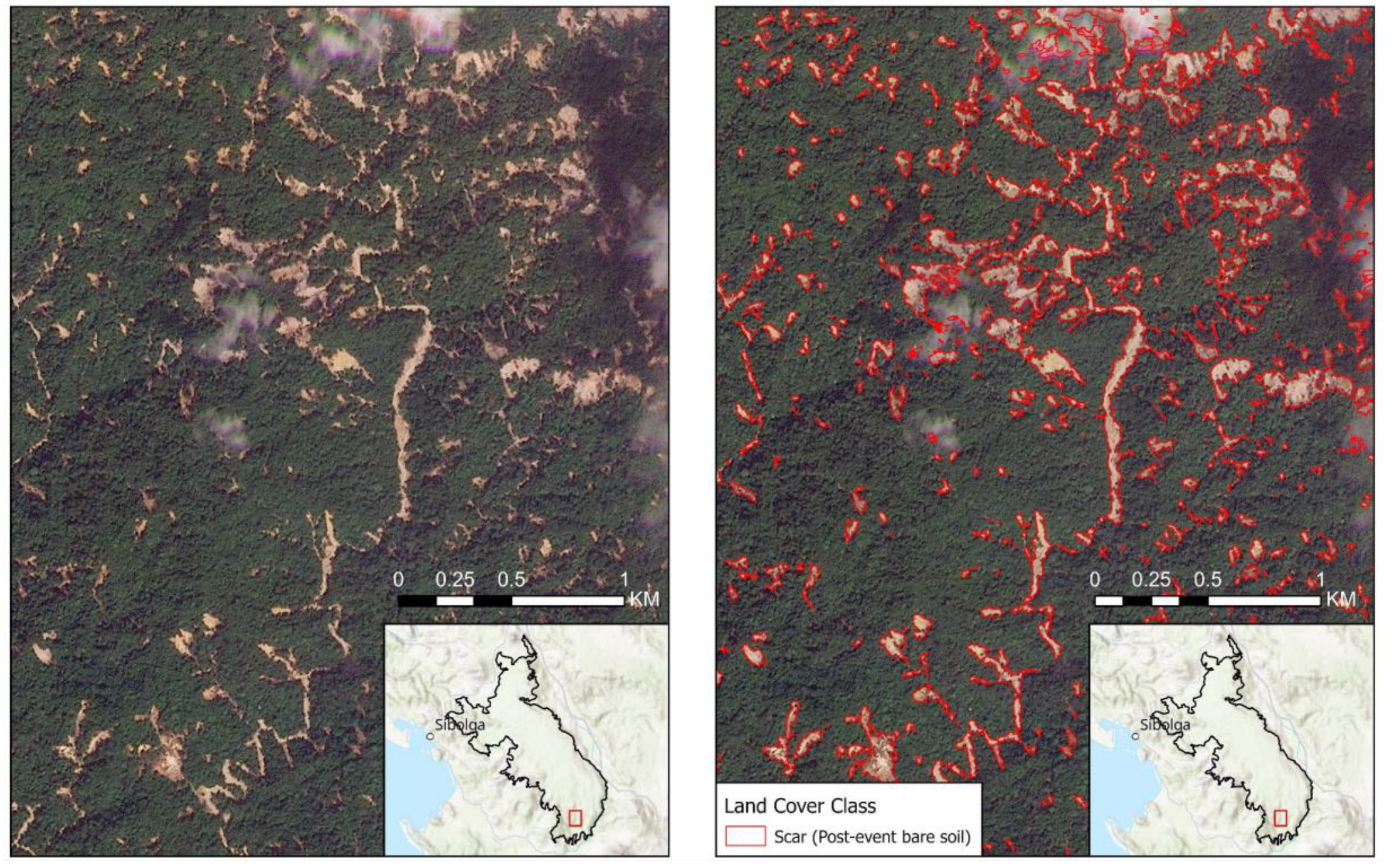
The Planetscope 3 m resolution image allowed us to verify the accuracy of the 10 m Sentinel-2 mapping, and to update this where cloud-free parts of the area were visible on the PlanetScope image (Figure 3). The classification of scars underestimates the actual total, because 25,729 ha (or 36% of the study area) is under cloud cover. If we assume that areas under cloud cover have the same occurrence of scars as cloud-free parts of the study area, then an additional 2,487 ha of scars may be present.
The classification accuracy assessment results for both image dates was high, with an Overall Accuracy of 87.50% and a Cohen’s Kappa of 0.83. For the 3 December classification, the individual classes demonstrated strong performance, with User’s Accuracies ranging from 80.39% for forest and 86.21% for scars, and Producer’s Accuracies ranging from 89.13% for forest and 94.74% for scars. There were 26,064 visible scars, with a mean scar size of 0.15 ha and a maximum area of 126 ha. 573 scars exceeded 1 ha in area, and 27 scars exceeded 10 ha.
Integrated Impact Layer and Number of Orangutans Affected
The scar mapping resulted in a total affected area of between 3,964 ha and 6,451 ha, in which we expect there to be near-zero food resources for orangutans for at least 5 years until pioneer forest regrowth once again starts producing food for orangutans [20].
The overlay of the 1km² orangutan density surface (2016 dataset) with the scar areas resulted in an estimated 33 orangutans directly impacted (Figure 3). This would increase to ~54 orangutans if we include assumed scars under cloud cover. These animals possibly either died during tree falls or landslides or drowned in flooded areas and flooded rivers. At least one orangutan death has been reported in the media [21], which appeared to be an animal that had drowned in a flood, with the corpse showing signs of severe abrasion. Given the scale of landslides, we expect that many more orangutans were killed or severely injured. We estimate that between 6.2 and 10.5% of the West Block population died or were injured during the 5 days of extreme rain. This single event likely exceeds the annual mortality limit of 1% required to drive the population into decline [20]. The demographic shock imposed by this event is consistent with an extinction-level disturbance.
4. Discussion
Biological Meaning of Losses
Great apes have low reproductive rates, and among them, the orangutans have the lowest, with interbirth intervals being between 6-9 years [22]. This, and the small size of the three isolated Tapanuli Orangutan populations, makes them extremely sensitive to unpredictable habitat disruption. Population modelling on Sumatran orangutans (before the identification of the Tapanuli orangutan), using a 2% probability of catastrophic events (i.e., occurring on average once every 50 years), killing 20% of the local population, did not affect the reproduction of surviving individuals [5]. November’s extreme rainfall event, however, exceeds these modelling assumptions, with frequency of these events being likely much higher than once every 50 years, and structural damage to forest and displacement of individuals into ecologically lower quality habitats likely reducing reproductive outputs.
The only modern example of catastrophic great ape mortality comes from the Ebola outbreaks that devastated western gorilla and chimpanzee populations in Central Africa in the early 2000s, where mortality reached 80–95% in several monitored groups [23]. By comparison, we estimate that the late-November 2025 extreme rainfall event in North Sumatra killed or severely impacted 6.2-10.5% of the Tapanuli orangutans in the West Block and displaced a part of the population into ecologically less productive habitat. Although proportional mortality is lower than that caused by Ebola, the demographic consequences for the Tapanuli orangutan could be more severe because fewer than 800 individuals survive, and the entire species is confined to three isolated population fragments in a mountain landscape. Moreover, while Ebola leaves habitat intact, the Sumatra event caused landscape-scale forest destruction, compounding mortality with long-term loss of nesting, feeding, and dispersal resources. Even though the West Block population can likely withstand this event if there are no further losses, the risk is that the impact of this event, compounded with future losses due to landcover change or another extreme rainfall event, will put the species in a downward spiral towards extinction.
Significance of Structural Forest Damage
Without detailed field surveys that assess structural damage to trees and loss of fruit and flowers, it is difficult to determine the impact of the rainfall event on the food availability in the orangutan habitat in the West Block. What is clear is that the visible damage does not just relate to reduced food resources, but likely also incurs increased energetic costs of moving through a highly disturbed and fragmented forest area [24]. Orangutans are highly specialized for energy-efficient arboreal locomotion in a continuous forest canopy, and movement through disturbed habitats imposes disproportionately high energetic costs. Increased canopy gaps force individuals to descend and ascend repeatedly, and vertical climbing is among the most metabolically expensive forms of primate locomotion, requiring up to several times the energy of horizontal travel [25]. Disturbance also reduces the density and distribution of fruiting trees, increasing travel distances between food patches and pushing orangutans toward negative energy balance (Knott 1998). Ground travel, which becomes more frequent in structurally damaged forests, carries elevated locomotor costs and risks, particularly where debris, mud, and unstable substrates persist after landslides and floods [26]. Because orangutans already operate near the lower limits of daily energy budgets, even modest increases in travel costs can reduce feeding time, impair reproduction, and elevate mortality [24]. Thus, the extensive structural forest damage documented in this event likely imposes significant energetic penalties on surviving Tapanuli orangutans, compounding direct mortality with sustained physiological stress and reduced long-term viability.
In addition to increased energetic costs, orangutans in the West Block have lost the highest quality habitats along river valleys. Orangutan densities in Batang Toru decline with elevation: < 300 m asl: 1.04 individuals/km2, 300 - 800 m asl: 0.91 individuals/km2; > 800 m asl: 0.69 individuals/km2 [after 3]. Looking at patterns of damage (Figure 2 and Figure 3), orangutans will likely be displaced towards lower habitat carrying capacity areas at higher elevations. Alternatively, orangutans will be pushed out of the West Block forest area into adjacent areas of agroforestry and agriculture, where resulting conflicts with farmers either result in injuries or deaths of orangutans, or the request to government authorities for wild-to-wild translocations [27]. We emphasize that such translocations could further undermine the population of the remaining orangutans [28].
Climate Change Link
In a rapid attribution study, Kew et al. [29] evaluated the contribution of human-induced climate change to the event, alongside the effects of the prevailing La Niña conditions and the negative phase of the Indian Ocean Dipole (IOD), both of which are known to amplify heavy rainfall and increase the likelihood of such events. For the Strait of Malacca, they estimated that the current La Niña and negative IOD conditions contributed about 5% to 13% to the intensity of the observed rainfall. When estimating the role of human-induced climate change in the event, they first used a method based on statistical modelling and rainfall observations [30], finding that despite relatively large discrepancies between different observation-based datasets, human-induced climate change has very likely increased both the intensity and likelihood of such extreme rainfall events compared to a pre-industrial climate. For the Malacca Strait region, the increase in extreme rainfall associated with rising global mean temperatures is estimated at about 9% to 50% [29]. This finding is very much in line with the scientific literature on the role of human-induced climate change on extreme rainfall events in Indonesia.
Globally, an increase in both the frequency and intensity of heavy precipitation has been observed, with projections showing further increases by the end of the 21st century [31,32]. This increase has also been observed over Southeast Asia, where there has been an increase in the variability and intensity of heavy rainfall over the period 1951 to 2014 [33].
Projections of extreme rainfall focusing on Indonesia [34] show large spatial and seasonal variations, but overall suggest an increase in wet extremes during the wet season, with the most extreme events surpassing records from the studied historical period of 1987-2014. The study further finds that in northern Sumatra, the wet season (December to February) is expected to become wetter and the dry season (June to August) drier. Breaking Indonesia into smaller regions, Marzuki et al. [35] found rainfall increases in Central–Northern Sumatra are concentrated from November to February, coinciding with the peak monsoon season. These increases are also linked to enhanced moisture transport from the Indian Ocean and South China Sea.
Policy Implications
The November extreme rainfall event exposed the structural vulnerability of the Tapanuli Orangutan, which is highly vulnerable to any population losses or decreases in habitat quality. For the Tapanuli orangutan, whose survival depends on near-zero mortality and stable, high-quality habitat, the scale of habitat destruction revealed here demonstrates that existing safeguards are insufficient for long-term viability.
The Government of Indonesia has taken an important step by temporarily halting major developments in the Batang Toru landscape, including mining, oil palm development and hydropower expansion [36]. This pause provides a rare opportunity to reassess ecological risks and reset development trajectories in light of the species’ extreme vulnerability. Consolidating this momentum will require converting the temporary halt into a structured review process that integrates updated climate-risk assessments, landslide susceptibility mapping, and new information about habitat carrying capacity following the storm. Strengthening and potentially expanding protection of lowland and riparian forests, improving conflict-mitigation capacity in areas where displaced orangutans may enter human-modified landscapes, and coordinating recovery through a dedicated government-led task force would help stabilize the population during the recovery period.
Given that climate change is increasing the likelihood of extreme rainfall events of the kind witnessed in November 2025, the international community also bears responsibility for supporting Indonesia’s efforts. This includes mobilizing rapid biodiversity-recovery financing, supplying technical expertise to improve hazard forecasting and restoration planning, and ensuring that global climate-finance mechanisms recognize the losses experienced by highly range-restricted species such as the Tapanuli Orangutan. International partners can further reinforce Indonesia’s leadership by co-developing green development alternatives that reduce pressure on the Batang Toru ecosystem while providing tangible local benefits.
Specifically, we strongly recommend an immediate moratorium on land-use activities that degrade remaining habitat; expansion of protected areas around the West Block and key corridors; a detailed orangutan habitat and population assessment; restoration of lowland forests critical for long-term recovery; and urgent consideration of designation of the Batang Toru ecosystem as a Kawasan Strategis Nasional, which would provide a stronger legal basis for long-term protection, integrate conservation and disaster-risk management across jurisdictions, and ensure that national spatial planning prioritizes ecosystem integrity and climate resilience over extractive and infrastructure pressures. Civil society groups have underscored that the Batang Toru landscape functions not only as critical biodiversity habitat but also as a climate buffer and water source for millions of people, and that strategic national status would enhance coordination across ministries and strengthen oversight of land-use decisions that contribute to ecological degradation and hydrometeorological hazards [37,38].
The crisis facing the Tapanuli orangutan illustrates the convergence of climate instability and biodiversity loss, calling for a coordinated response that matches the scale of the threat. Indonesia’s immediate actions have created political space for decisive conservation measures, but sustained international support will be essential. Through a combination of strengthened domestic protections, climate-responsive planning, and global financial and technical assistance, it remains possible to prevent the first modern extinction of a great ape species and demonstrate a shared commitment to safeguarding irreplaceable biodiversity in a rapidly changing climate.
5. Conclusions
This event illustrates the growing threat that climate-driven extreme events pose to species already pushed to the brink of extinction by habitat loss. Without immediate intervention, the Tapanuli orangutan faces the imminent risk of becoming the first great ape species to go extinct in modern history.
Author Contributions
For research articles with several authors, a short paragraph specifying their individual contributions must be provided. The following statements should be used “Conceptualization, E.M., D.G. and S.W.; methodology, M.W., SN., R.D., N.U. and A.D.; writing—original draft preparation, E.M., R.D., P.H., D.S., A.D., H.K., F.O..; writing—review and editing, D.S., J.S., E.A., S.W.; visualization, M.W., S.N..; supervision, E.M. All authors have read and agreed to the published version of the manuscript.
Funding
This research received no external funding.
Conflicts of Interest
The authors declare no conflict of interest.
Appendix A
Figure A1.
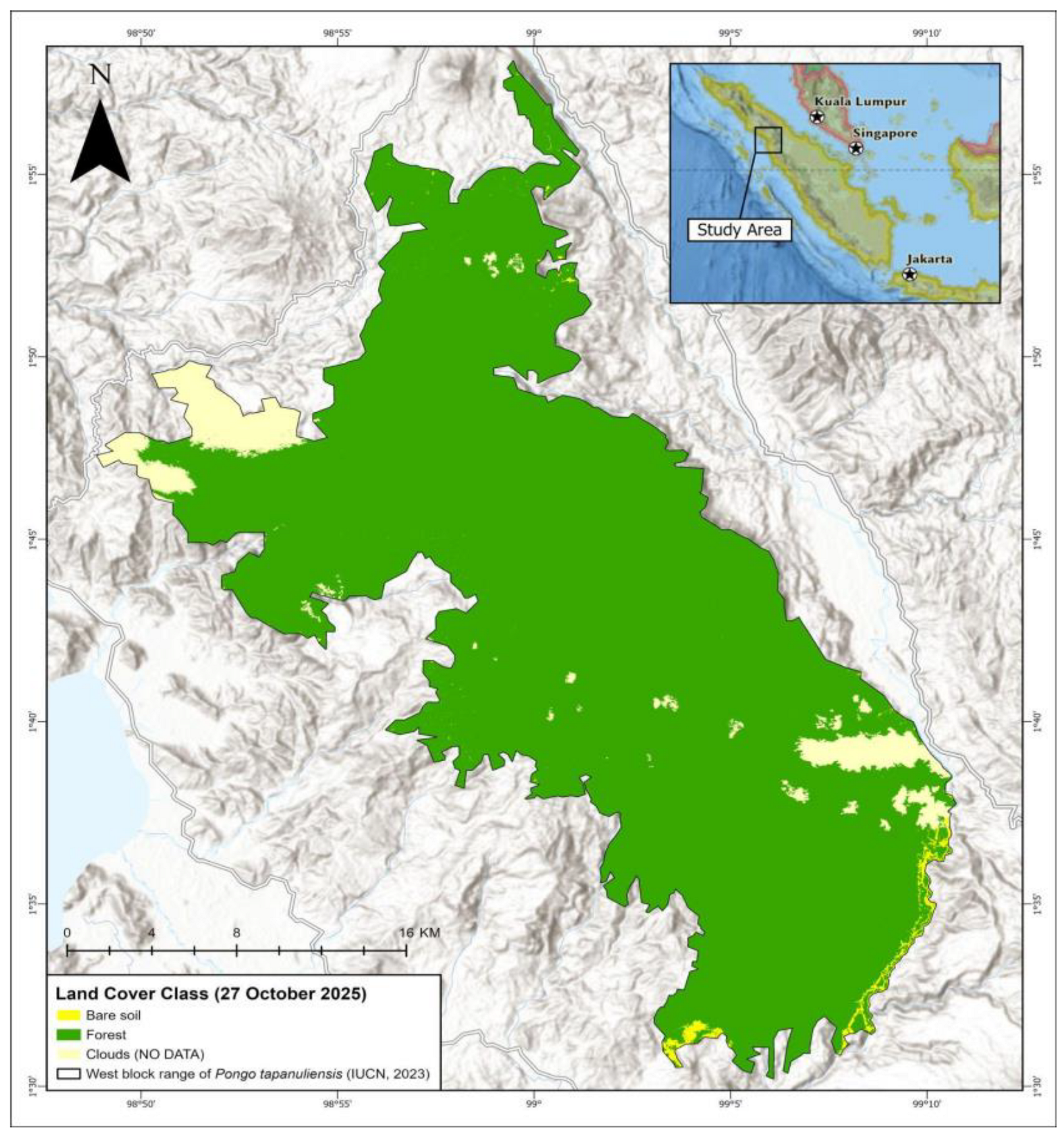
Map of forest cover in the Batang Toru West Block prior to the extreme rainfall event..Green = forest, yellow = bare soil, white = cloud (no data). The delineated area is the boundary of the West Block Tapanuli Orangutan population (Wich et al. 2023). Base map data derived from the Esri Topographic Map Service (Base map data derived from the Esri Topographic Map Service (Source: Esri, TomTom, Garmin, FAO, NOAA, USGS, ©OpenStreetMap contributors,and the GIS User Community).
Figure A1.
Map of forest cover in the Batang Toru West Block prior to the extreme rainfall event..Green = forest, yellow = bare soil, white = cloud (no data). The delineated area is the boundary of the West Block Tapanuli Orangutan population (Wich et al. 2023). Base map data derived from the Esri Topographic Map Service (Base map data derived from the Esri Topographic Map Service (Source: Esri, TomTom, Garmin, FAO, NOAA, USGS, ©OpenStreetMap contributors,and the GIS User Community).
References
- Wich SA, Fredriksson G, Usher G, Kuhl H, Nowak M. The Tapanuli orangutan: Status, threats and steps for improved conservation. Conservation Science and Practice. 2019:e33. doi: 10.1111/csp2.33.
- Nater A, Mattle-Greminger MP, Nurcahyo A, Nowak MG, de Manuel M, Desai T, et al. Morphometric, Behavioral, and Genomic Evidence for a New Orangutan Species. Current Biology. 2017;27(22):3487-98.e10. doi: 10.1016/j.cub.2017.09.047.
- Wich SA, Singleton I, Nowak MG, Utami Atmoko SS, Nisam G, Arif SM, et al. Land-cover changes predict steep declines for the Sumatran orangutan (Pongo abelii). Science Advances. 2016;2(3):e1500789. doi: 10.1126/sciadv.1500789.
- Laurance WF, Wich SA, Onrizal O, Fredriksson G, Usher G, Santika T, et al. Tapanuli orangutan endangered by Sumatran hydropower scheme. Nature Ecology & Evolution. 2020;4(11):1438-9. doi: 10.1038/s41559-020-1263-x.
- Marshall AJ, Lacy R, Ancrenaz M, Byers O, Husson S, Leighton M, et al. Orangutan population biology, life history, and conservation. Perspectives from population viability analysis models. In: Wich S, Atmoko SU, Mitra Setia T, van Schaik CP, editors. Orangutans: geographic variation in behavioral ecology and conservation. Oxford, UK: Oxford University Press; 2009. p. 311-26.
- Meijaard E, Ni’matullah S, Dennis R, Sherman J, Onrizal, Wich SA. The historical range and drivers of decline of the Tapanuli orangutan. PLOS ONE. 2021;16(1):e0238087. doi: 10.1371/journal.pone.0238087.
- Wich S, Meijaard E. Saving the Tapanuli orangutan requires zero losses. Oryx. 2021;55(1):10-1. Epub 2021/01/11. doi: 10.1017/S0030605320001052.
- Muazam AR, Karokaro AS, Wijaya T. Death toll rises in Sumatra flood catastrophe as gov’t moves to protect Batang Toru forest. https://news.mongabay.com/2025/12/death-toll-rises-in-sumatra-flood-catastrophe-asgovt- moves-to-protect-batang-toru-forest/. Accessed on 11 December 2025. Mongabay. 2025;9 December 2025.
- BMKG. Stasiun Meteorology Sumatera Barat. Laporan Iklim Harian. Downloaded from https://dataonline.bmkg.go.id/data-harian. 2025.
- India Meteorological Department. Press release 25th November, 2025. The Well-Marked low-pressure area over Malaysia & adjoining Strait of Malacca intensified into depression over strait of Malacca. https://internal.imd.gov.in/press_release/20251125_pr_4498.pdf. Accessed on 11 December 2025. 2025.
- Qing A, Begum S. Cyclone Senyar was rare for Southeast Asia – could a storm like it ever hit Singapore?. https://asianews.network/cyclone-senyar-was-rare-for-southeast-asia-could-a-storm-like-it-ever-hitsingapore/. Accessed on 11 December 2025. The Strait Times. 2025;11 December 2025.
- Kiribou R, Tehoda P, Chukwu O, Bempah G, Kühl HS, Ferreira J, et al. Exposure of African ape sites to climate change impacts. PLOS Climate. 2024;3(2):e0000345. doi: 10.1371/journal.pclm.0000345.
- Wich SA, Ni’Matullah S, Sherman J, Meijaard E. Spatial data for P. tapanuliensis Red Listing. Borneo Futures, Brunei Darussalam 2023. Pongo tapanuliensis. The IUCN Red List of Threatened Species. Version 2025-2. 2023.
- Garrido-Pérez EI, Dupuy JM, Durán-García R, Ucan-May M, Schnitzer SA, Gerold G. Effects of lianas and Hurricane Wilma on tree damage in the Yucatan Peninsula, Mexico. Journal of Tropical Ecology. 2008;24(5):559-62. Epub 2008/09/01. doi: 10.1017/S0266467408005221.
- Putz FE. The natural history of lianas on Barro Colorado Island, Panama. Ecology. 1984;65:1713-24.
- Negrón-Juárez RI, Chambers JQ, Guimaraes G, Zeng H, Raupp CFM, Marra DM, et al. Widespread Amazon forest tree mortality from a single cross-basin squall line event. Geophysical Research Letters. 2010;37(16). doi: https://doi.org/10.1029/2010GL043733.
- Agincourt Resources. Agincourt Resources’ Response to the Garoga Flood: Fast, Fact-Based Action. 2 December 2025. https://agincourtresources.com/2025/12/02/agincourt-resources-response-to-the-garogaflood- fast-fact-based-action/?utm_source=chatgpt.com. Accessed on 10 December 2025. 2025.
- Gründemann GJ, van de Giesen N, Brunner L, van der Ent R. Rarest rainfall events will see the greatest relative increase in magnitude under future climate change. Communications Earth & Environment. 2022;3(1):235. doi: 10.1038/s43247-022-00558-8.
- Pepin NC, Arnone E, Gobiet A, Haslinger K, Kotlarski S, Notarnicola C, et al. Climate Changes and Their Elevational Patterns in the Mountains of the World. Reviews of Geophysics. 2022;60(1):e2020RG000730. doi: https://doi.org/10.1029/2020RG000730.
- Ardi R. Ekologi Suksesi Habitat Orangutan Sumatera di Hutan Dataran Rendah dan Hutan Rawa Gambut. MSc Dissertation. Universitas Sumatera Utara. Medan. 2023 doi: https://repositori.usu.ac.id/handle/123456789/87752.
- Khadka NS. Fears grow that world’s rarest apes were swept away in Sumatran floods. https://www.bbc.com/news/articles/cj4q1l0ly7wo. Accessed on 12 December 2025. BBC. 2025;12 December 2025.
- Wich SA, Atmoko SU, Setia TM, van Schaik C. Orangutans. Geographic variation in behavioral ecology and conservation. Oxford, UK: Oxford University Press; 2009.
- Leroy EM, Rouquet P, Formenty P, Souquière S, Kilbourne A, Froment J-M, et al. Multiple Ebola Virus Transmission Events and Rapid Decline of Central African Wildlife. Science. 2004;303(5656):387-90. doi: 10.1126/science.1092528.
- Vogel ER, Knott CD, Crowley BE, Blakely MD, Larsen MD, Dominy NJ. Bornean orangutans on the brink of protein bankruptcy. Biology Letters. 2011;8(3):333-6. doi: 10.1098/rsbl.2011.1040.
- Halsey LG, Coward SRL, Thorpe SKS. Bridging the gap: parkour athletes provide new insights into locomotion energetics of arboreal apes. Biology Letters. 2016;12(11). doi: 10.1098/rsbl.2016.0608.
- Spehar SN, Rayadin Y. Habitat use of Bornean Orangutans (Pongo pygmaeus morio) in an Industrial Forestry Plantation in East Kalimantan, Indonesia. International Journal of Primatology. 2017:1-27. doi: 10.1007/s10764-017-9959-8.
- Sherman J, Voigt M, Ancrenaz M, Meijaard E, Oram F, Williamson EA, et al. Outcomes of orangutan wildto- wild translocations reveal conservation and welfare risks. PLOS ONE. 2025;20(3). doi: 10.1371/journal.pone.0317862.
- Sherman J, Voigt M, Ancrenaz M, Wich SA, Qomariah IN, Lyman E, et al. Orangutan killing and trade in Indonesia: Wildlife crime, enforcement, and deterrence patterns. Biological Conservation. 2022;276:109744. doi: https://doi.org/10.1016/j.biocon.2022.109744.
- Kew S, Zachariah M, Barnes C, Rajapakse L, Basconcillo J. Increasing heavy rainfall and extreme flood heights in a warming climate threaten densely populated regions across Sri Lanka and the Malacca Strait. World Weather Attribution scientific report. 2025;No. 78. doi: https://doi.org/10.25560/126259.
- van Oldenborgh GJ, van der Wiel K, Kew S, Philip S, Otto F, Vautard R, et al. Pathways and pitfalls in extreme event attribution. Climatic Change. 2021;166(1):13. doi: 10.1007/s10584-021-03071-7.
- Alexander LV, Arblaster JM. Historical and projected trends in temperature and precipitation extremes in Australia in observations and CMIP5. Weather and Climate Extremes. 2017;15:34-56. doi: https://doi.org/10.1016/j.wace.2017.02.001.
- Seneviratne SI, Zhang X, Adnan M, Badi W, Dereczynski C, Di Luca A, et al. Weather and Climate Extreme Events in a Changing Climate. . In: Masson-Delmotte V, Zhai P, Pirani A, Connors SL, Péan C, Berger S, et al., editors. Climate Change 2021: The Physical Science Basis Contribution of Working Group I to the Sixth Assessment Report of the Intergovernmental Panel on Climate Change. Cambridge, United Kingdom and New York, NY, USA: Cambridge University Press; 2021. p. 1513–766.
- Singh V, Qin X. Study of rainfall variabilities in Southeast Asia using long-term gridded rainfall and its substantiation through global climate indices. Journal of Hydrology. 2020;585:124320. doi: https://doi.org/10.1016/j.jhydrol.2019.124320.
- Kurniadi A, Weller E, Salmond J, Aldrian E. Future projections of extreme rainfall events in Indonesia. International Journal of Climatology. 2024;44(1):160-82. doi: https://doi.org/10.1002/joc.8321.
- Marzuki M, Ramadhan R, Yusnaini H, Vonnisa M, Muharsyah R, Nugraha Y, et al. Long-Term Spatial– Temporal Variability, Trends and Extreme Rainfall Events Over Indonesia Based on 43 Years of CHIRPS Data. International Journal of Climatology. 2025;45(14):e70107. doi: https://doi.org/10.1002/joc.70107.
- Wirayani P. Indonesia Halts Agincourt, PTPN III Operations After Floods. https://www.bloomberg.com/news/articles/2025-12-06/indonesia-halts-agincourt-ptpn-iii-operationsafter- floods. Accessed on 11 December 2025. Bloomberg. 2025;6 December 2025.
- Manaf A. Green Justice Desak Pemerintah Tetapkan Ekosistem Batang Toru Jadi Kawasan Strategis Nasional. https://www.rmolsumut.id/green-justice-desak-pemerintah-tetapkan-ekosistem-batang-torujadi- kawasan-strategis-nasional. Accessed on 12 December 2025. RMol Sumut. 2025;9 December 2025.
- Wicaksono RA. Ekosistem Batang Toru Diminta Jadi Kawasan Strategis Nasional. https://betahita.id/news/detail/11641/ekosistem-batang-toru-diminta-jadi-kawasan-strategisnasional. html?v=1765508098. Accessed on 12 December 2025. Betahita. 2025;10 December 2025.
Figure 1.
Map of scars (post-event). Green = forest, red = bare soil indicating flooding and landslides, white = cloud (no data). The delineated area is the boundary of the West Block Tapanuli Orangutan population (Wich et al. 2023). Base map data derived from the Esri Topographic Map Service (Source: Esri, TomTom, Garmin, FAO, NOAA, USGS, ©OpenStreetMap contributors, and the GIS User Community).
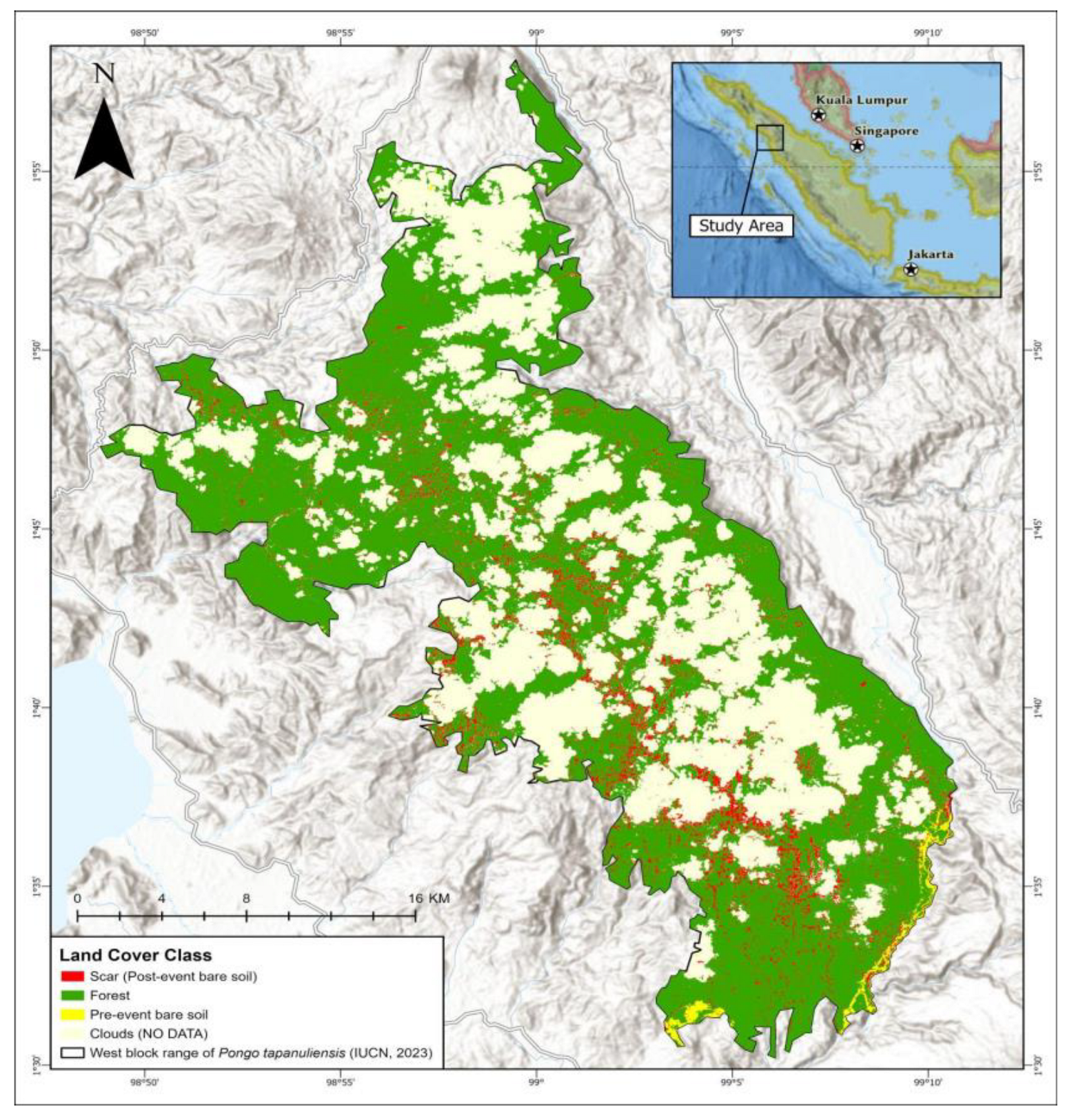
Figure 2.
Pre- and post event imagery. Left Sentinel-2 image dated 27 October 2025 showing full forest cover. Right Sentinel-2 image of the same area dated 3 December 2025 showing extent of scars (cream colour), clouds and remaining forest. Image: Copernicus Sentinel data 2025; Base map data derived from the Esri Topographic Map Service (Source: Esri, TomTom, Garmin, FAO, NOAA, USGS, ©OpenStreetMap contributors, and the GIS User Community).
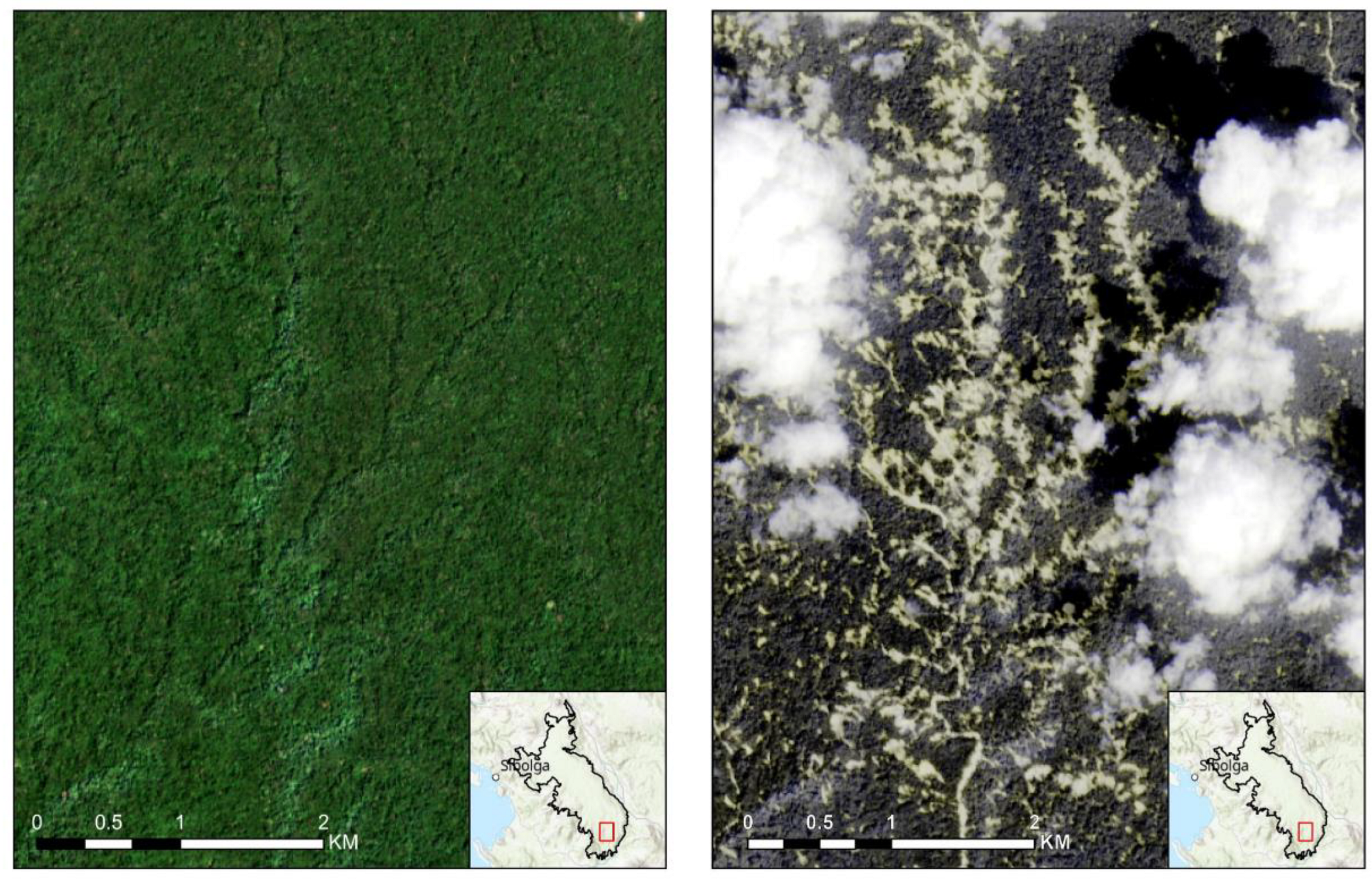
Figure 3.
High-resolution imagery showing impact on forest cover and the results of the scar mapping as red polygons. Image courtesy of MightyEarth and PlanetScope.
Figure 3.
High-resolution imagery showing impact on forest cover and the results of the scar mapping as red polygons. Image courtesy of MightyEarth and PlanetScope.
Disclaimer/Publisher’s Note: The statements, opinions and data contained in all publications are solely those of the individual author(s) and contributor(s) and not of MDPI and/or the editor(s). MDPI and/or the editor(s) disclaim responsibility for any injury to people or property resulting from any ideas, methods, instructions or products referred to in the content. |
© 2025 by the authors. Licensee MDPI, Basel, Switzerland. This article is an open access article distributed under the terms and conditions of the Creative Commons Attribution (CC BY) license (http://creativecommons.org/licenses/by/4.0/).
Copyright: This open access article is published under a Creative Commons CC BY 4.0 license, which permit the free download, distribution, and reuse, provided that the author and preprint are cited in any reuse.


