Preprint
Review

This version is not peer-reviewed.

Harnessing Regenerative Agriculture, Unmanned Aerial Systems, and Artificial Intelligence for Sustainable Cocoa Farming in West Africa: A review

Submitted:

14 November 2025

Posted:

14 November 2025

You are already at the latest version

Abstract

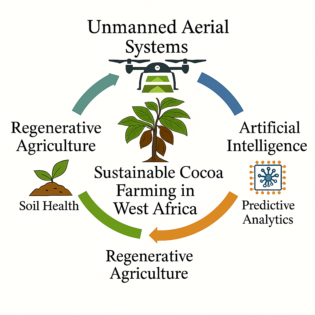
Cocoa production in West Africa—dominated by Côte d’Ivoire, Ghana, Nigeria, Cameroon, and Togo—faces interconnected agronomic, environmental, and socio-economic challenges that limit productivity and threaten smallholder livelihoods. Integrating Regenerative Agriculture (RA), Unmanned Aerial Systems (UAS), and Artificial Intelligence (AI) present a transformative framework for achieving sustainable and climate-resilient cocoa farming. This review synthesizes evidence from 2000 to 2024 and establishes a tri-axial model that unites ecological regeneration, spatial diagnostics, and predictive intelligence. Regenerative practices such as composting, mulching, cover cropping, and agroforestry rebuild soil organic matter, enhance biodiversity, and strengthen ecosystem services. UAS-based multispectral, thermal, and LiDAR sensing provide high-resolution insights into canopy vigor, nutrient stress, and microclimatic variability across heterogeneous cocoa landscapes. When coupled with AI-driven analytics for crop classification, disease detection, yield forecasting, and decision support, these tools collectively enhance soil organic carbon by 15–25%, stabilize yields by 12–28%, and reduce fertilizer and water inputs by 10–20%. The integrated RA–UAS–AI framework also facilitates carbon-credit quantification, ecosystem-service valuation, and inclusive participation through cooperative drone networks. Overall, this convergence defines a precision-regenerative model tailored to West African cocoa systems, aligning productivity gains with ecological restoration, resilience, and regional sustainability.

Keywords: 
;  ;  ;  ;  

1. Introduction

Cocoa cultivation remains central to the economies and rural livelihoods of West Africa, accounting for over 70 % of global supply and directly supporting more than six million smallholder farmers [1,2,3]. Côte d’Ivoire and Ghana together contribute roughly 60 % of world exports, while Nigeria, Cameroon, and Togo make up much of the remainder [4,5] (Figure 1).
Despite this dominance, productivity has stagnated at 400–600 kg ha⁻¹, far below the crop’s biological potential of 1,500–2,000 kg ha⁻¹ achievable under optimal agronomic and climatic conditions [6,7,8].
This persistent yield gap stems from interrelated constraints—declining soil fertility, aging tree populations, pest and disease pressure, and climatic variability—that erode both productivity and sustainability [9,10,11]. Continuous cultivation without adequate nutrient replenishment has depleted organic matter and weakened soil structure, while nutrient mining and erosion reduce the soil’s capacity to retain water and nutrients [12,13]. Moreover, climate-related shifts—especially irregular rainfall patterns and rising temperatures exceeding 2 °C above historical means in some production belts—are altering the suitability of traditional cocoa-growing zones [14,15]. Collectively, these pressures underscore the need to re-engineer production systems that enhance soil health, sustain yields, and build resilience to climate change.

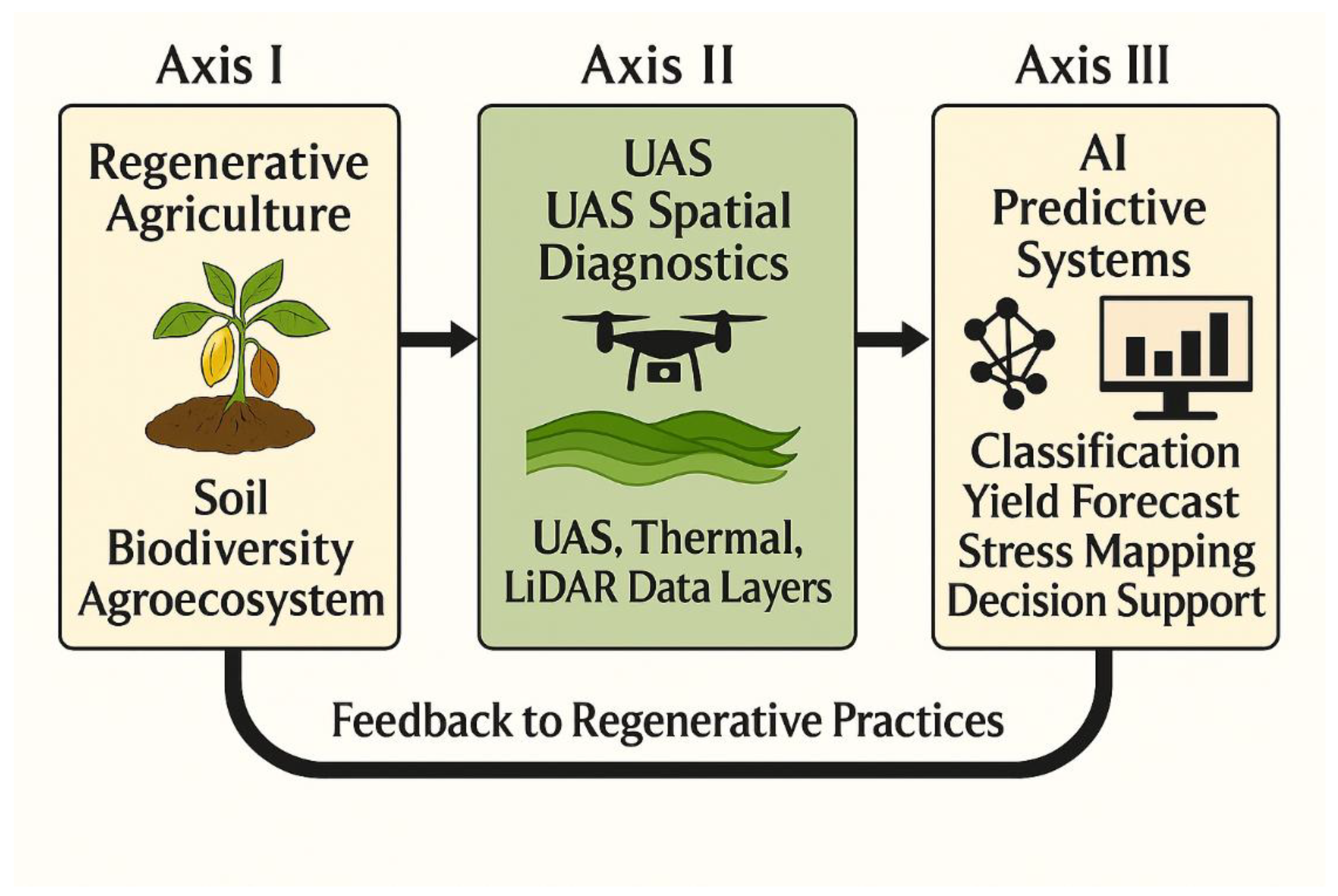
1.2. Integrating Regenerative, Aerial, and Analytical Approaches

Regenerative Agriculture (RA) provides an ecologically grounded framework that restores soil function through minimal tillage, organic composting, cover cropping, mulching, and integrated agroforestry [16,17,18]. These practices increase soil organic carbon, stimulate biological activity, and promote microclimate stability—key to long-term fertility restoration and carbon sequestration. Yet, their success depends on accurate spatial information that guides management at the sub-field level.
Unmanned Aerial Systems (UAS) complement this need by delivering high-resolution, multispectral and thermal imagery that reveals canopy vigor, soil-moisture gradients, and early stress signals [19,20]. UAS-based vegetation indices such as NDVI, EVI, and SAVI, along with LiDAR-derived canopy models, provide spatial diagnostics essential for site-specific regenerative interventions. When coupled with Artificial Intelligence (AI)—including machine-learning and deep-learning models—these data streams are transformed into predictive intelligence for yield forecasting, nutrient optimization, and disease detection.
The convergence of RA, UAS, and AI therefore marks a paradigm shift from generalized management toward data-informed regenerative intensification—combining ecological restoration with digital precision. This triadic integration has the potential to improve productivity while minimizing environmental footprints across heterogeneous West African cocoa landscapes.

1.3. Objectives of the Review

This review synthesizes two decades (2000–2024) of peer-reviewed and institutional evidence to:
  • Assess current knowledge on the application of RA, UAS, and AI in cocoa production systems across West Africa.
  • Evaluate how their integration enhances soil health, productivity, and ecological sustainability; and
  • Identify enabling policies, institutional frameworks, and research priorities to scale regenerative, technology-enabled cocoa farming.

1.4. Reader Roadmap

To aid navigation and ensure coherence, the paper is organized as follows:
  • Section 2 details the methodological framework and literature-selection process following PRISMA 2020 guidelines.
  • Section 3 examines regional cocoa-production systems, yield trends, and agronomic constraints.
  • Section 4 synthesizes regenerative-agriculture principles and field-validated practices.
  • Section 5 presents UAS-based spatial monitoring—NDVI, thermal, and LiDAR analyses.
  • Section 6 discusses deep-learning and analytical applications in cocoa farming.+
  • Section 7, Section 8 and Section 9 integrate case studies, economic implications, and strategic policy recommendations
Given the diversity of biophysical, technological, and socio-economic factors influencing cocoa production in West Africa, a structured synthesis approach is essential for drawing coherent insights. To achieve this, the review employed a systematic literature-assessment framework that ensures transparency, replicability, and analytical rigor. Following the PRISMA 2020 protocol, relevant studies were identified, screened, and categorized across regenerative, aerial, and analytical dimensions. The next section (Section 2) outlines this methodological framework, including search strategy, eligibility criteria, and analytical structure used to integrate evidence from 2000–2024.

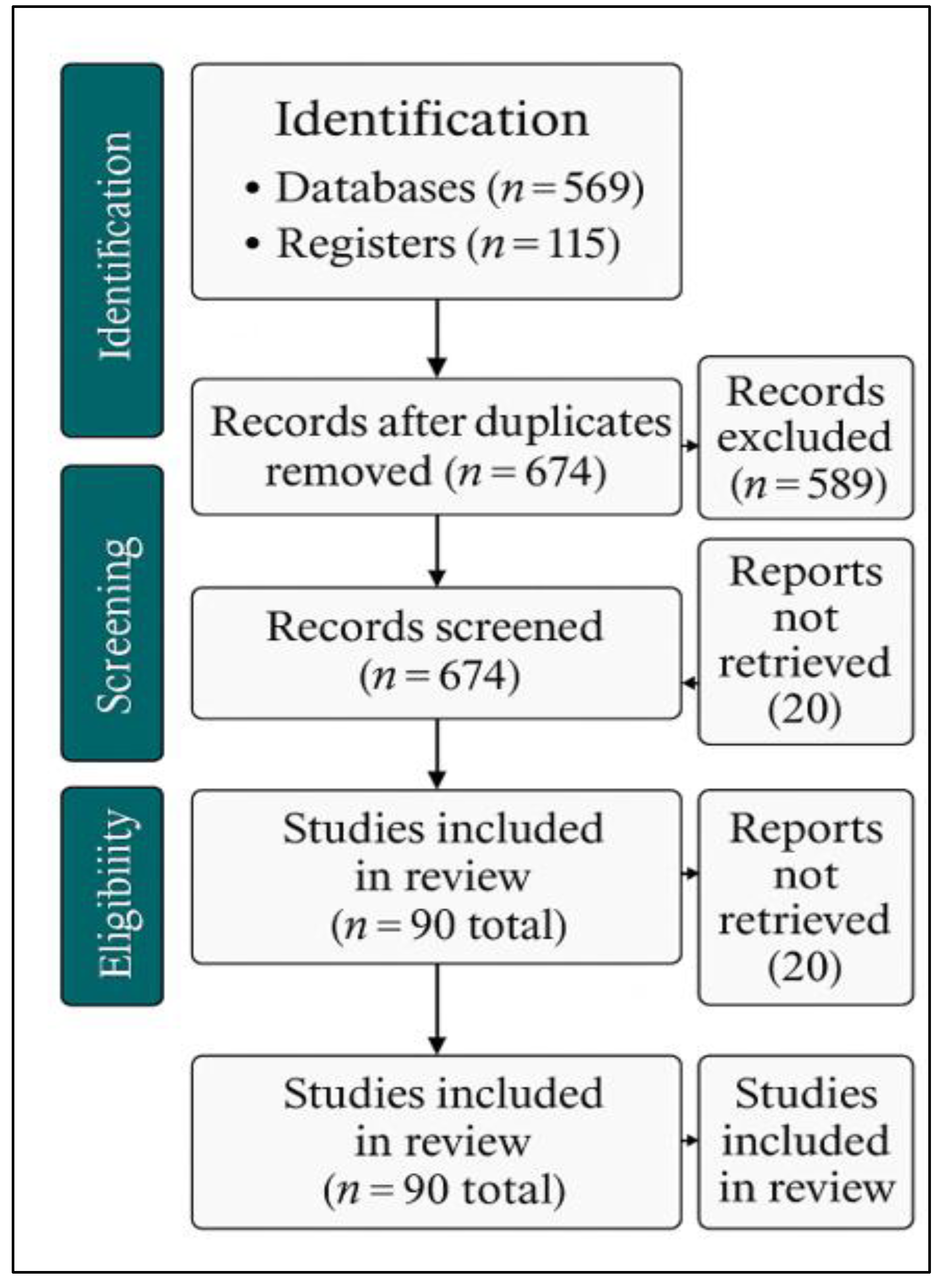
2. Methodological Framework

2.1. Review Protocol and Rationale

This systematic review adhered to the Preferred Reporting Items for Systematic Reviews and Meta-Analyses (PRISMA 2020) guidelines to ensure methodological transparency, reproducibility, and analytical rigor. The PRISMA protocol was selected because it minimizes bias and enhances comparability across heterogeneous research domains, particularly in agricultural and environmental syntheses [16,18,19]. The framework structures the review process into four sequential stages, identification, screening, eligibility, and inclusion, thereby providing a clear audit trail of study selection (Figure 2).
The review focused on three analytical dimensions central to the study’s objectives:
  • Regenerative Agriculture (RA), emphasizing soil-health restoration, biodiversity, and ecological resilience [10,11,12,13,45,46,47].
  • Unmanned Aerial Systems (UAS), involving multispectral, thermal, and LiDAR sensing for spatial monitoring of cocoa systems [19,20,60,78,79,80,81,82,83]; and
  • Artificial Intelligence (AI), integrating machine- and deep-learning models for classification, segmentation, yield estimation, and decision support [120,121,122,123,124,125,126,127,144].
This tripartite organization reflects a top-down analytical structure that links ecological processes to technological innovations, consistent with editorial guidance for thematic coherence and disciplinary integration.

2.2. Search Strategy and Data Sources

The literature search targeted peer-reviewed and institutional publications between January 2000 and December 2024, representing the emergence of UAS and AI applications in precision agriculture [81,82,83,120,121,122].
In addition to peer-reviewed literature, authoritative institutional repositories were incorporated to enhance the breadth and replicability of the review process. The Food and Agriculture Organization (FAO) references [2,20] were included to reflect global and regional datasets, digital-agriculture frameworks, and climate-policy guidance directly relevant to West African cocoa systems. Their inclusion ensures methodological transparency, harmonization with international reporting standards, and contextual linkage between regenerative-agriculture practices and current FAO sustainability strategies.
Boolean search strings were formulated as:
(“Cocoa” OR “Theobroma cacao”) AND (“Regenerative Agriculture” OR “Sustainable Farming” OR “Agroforestry”) AND (“Unmanned Aerial Systems” OR “UAV” OR “Drone” OR “Remote Sensing”) AND (“Artificial Intelligence” OR “Machine Learning” OR “Deep Learning”) AND (“West Africa” OR “Côte d’Ivoire” OR “Ghana” OR “Nigeria” OR “Cameroon” OR “Togo”).
Searches were conducted across Scopus, Web of Science, ScienceDirect, AGRICOLA, and Google Scholar, supplemented by institutional repositories such as FAO [2,20], ICCO [1], and Ghana COCOBOD [21]. A total of 790 records were retrieved (758 from databases and 32 from grey literature) (Figure 2). After de-duplication, 621 unique records were retained for screening. This comprehensive Boolean strategy ensured inclusion of ecological, technological, and socio-economic dimensions relevant to cocoa production in West Africa.

2.3. Inclusion and Exclusion Criteria

Eligibility was determined by the following inclusion criteria:
  • Studies addressed Theobroma cacao systems within West Africa.
  • Focused on at least one of the three analytical domains (RA, UAS, or AI).
  • Reported empirical, experimental, or modeling data on productivity, soil health, or sustainability.
  • Were written in English and accessible in full text.
Exclusion criteria applied to studies that lacked methodological detail, were non-empirical, outside the geographic scope, or derived from low-credibility sources. Detailed exclusion outcomes are summarized in Table 1.
Following the systematic search process outlined in Table 1, the PRISMA 2020 flow diagram (Figure 1) visualizes the sequential stages of literature identification, screening, and eligibility. Records were first retrieved from major databases and institutional repositories (n = 790) and then refined through de-duplication (n = 674). After abstract and full-text screening, studies were excluded primarily because they were conducted outside West Africa, lacked methodological detail, or represented grey literature with incomplete data. The final set of 49 studies formed the analytical basis of this review, while 90 studies were retained overall to support regional thematic synthesis.

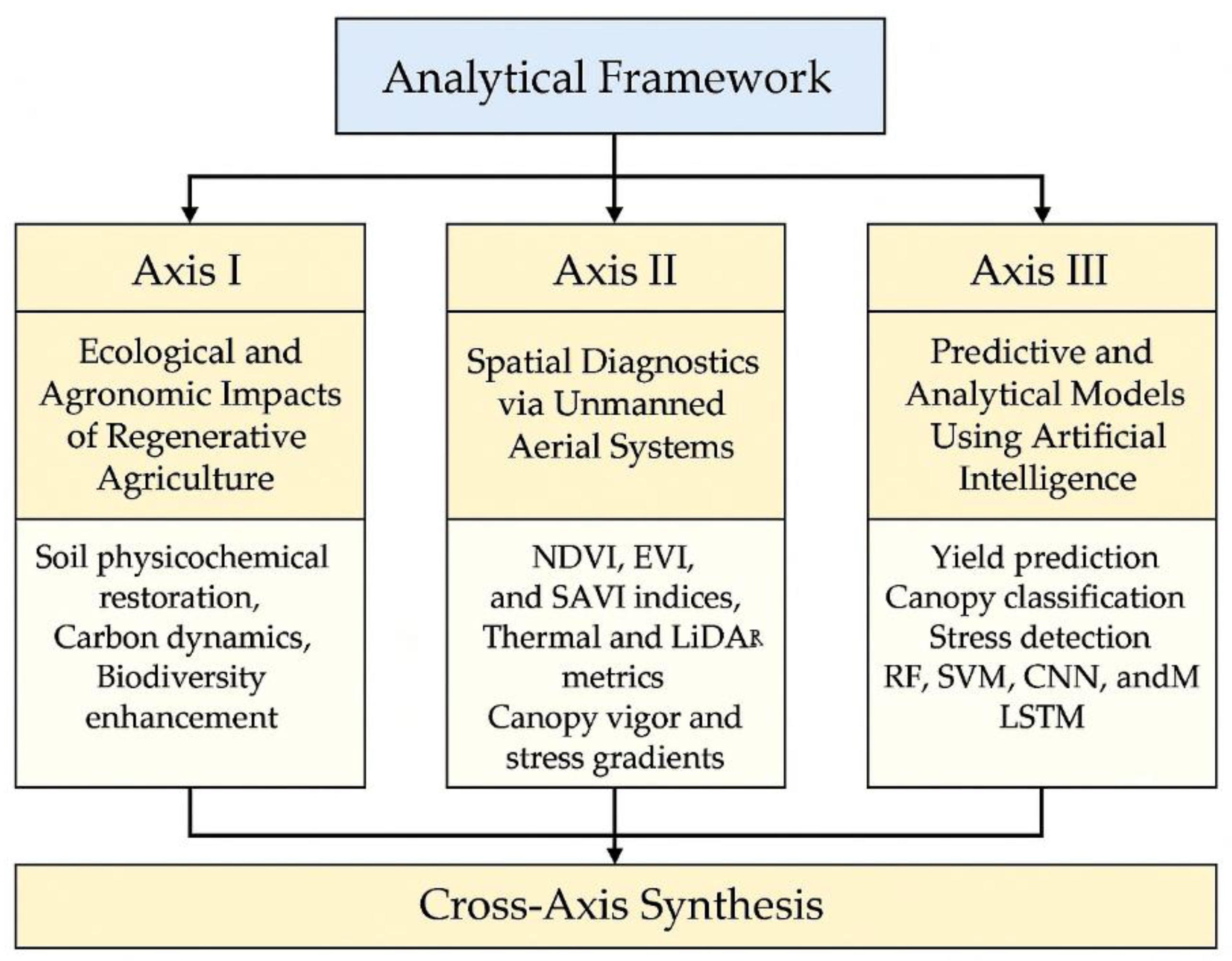
2.4. Analytical Framework and Synthesis Approach

To ensure conceptual clarity and maintain a top-down analytical flow, the synthesis was organized along three interlinked thematic axes (Figure 3). This conceptual analytical framework defines the structural organization of this study along three thematic axes, RA, UAS, and AI. Each axis represents a complementary analytical dimension that informs the broader synthesis of precision-regenerative cocoa management.
Axis I focuses on the ecological and agronomic impacts of regenerative agriculture, emphasizing soil physicochemical restoration, carbon dynamics, and biodiversity enhancement.
Axis II centers on spatial diagnostics using unmanned aerial systems (UAS), employing NDVI, EVI, SAVI, thermal, and LiDAR metrics to characterize canopy vigor and stress gradients.
Axis III highlights predictive and analytical modeling through artificial intelligence (AI), including Random Forest (RF), Support Vector Machine (SVM), Convolutional Neural Network (CNN), and Long Short-Term Memory (LSTM) architectures for yield prediction, canopy classification, and stress detection.
This analytical framework builds directly upon the production capacities and agronomic constraints discussed in Section 3, which provides the contextual foundation for the cross-axis synthesis integrating RA, UAS, and AI dimensions in precision-regenerative cocoa management. While Figure 3 provides theoretical foundation, its operational integration is further illustrated later in the review where data from the three axes are synthesized into site-specific management decisions.

2.5. Quality Assessment and Validation

A five-criterion rubric evaluated each study’s (1) clarity of objectives, (2) data transparency, (3) methodological rigor, (4) reproducibility, and (5) policy relevance [19,20]. Studies scoring < 3 of 5 were excluded. Inter-reviewer agreement was high (Cohen’s κ = 0.87). Quantitative models were validated through statistical performance (R², RMSE, accuracy %) and external datasets (FAO soil maps, UAVid vegetation datasets) [130,131,132,133].
This rigorous validation ensured that all retained studies met both methodological and contextual standards for inclusion in the cross-axis synthesis.

2.6. Output Summary

The 90 retained studies form a representative body of evidence across cocoa-producing nations, Ghana and Côte d’Ivoire (n = 38), Nigeria (n = 22), Cameroon (n = 18), and Togo (n = 12). Ecological RA research accounted for 42 %, UAS-based spatial analysis 33 %, and AI-based predictive modeling 25 %. The methodological progression observed, from descriptive field surveys to AI-driven, spatially explicit diagnostics, demonstrates a regional shift toward precision-regenerative cocoa management [81,82,83,120,121,122,123,124,125,126,127,134,135,136].
While 49 studies met the strict inclusion criteria for PRISMA meta-analysis, a total of 90 studies, including contextual and regionally relevant references, were retained to inform the thematic synthesis developed in Sections 3 through 9.

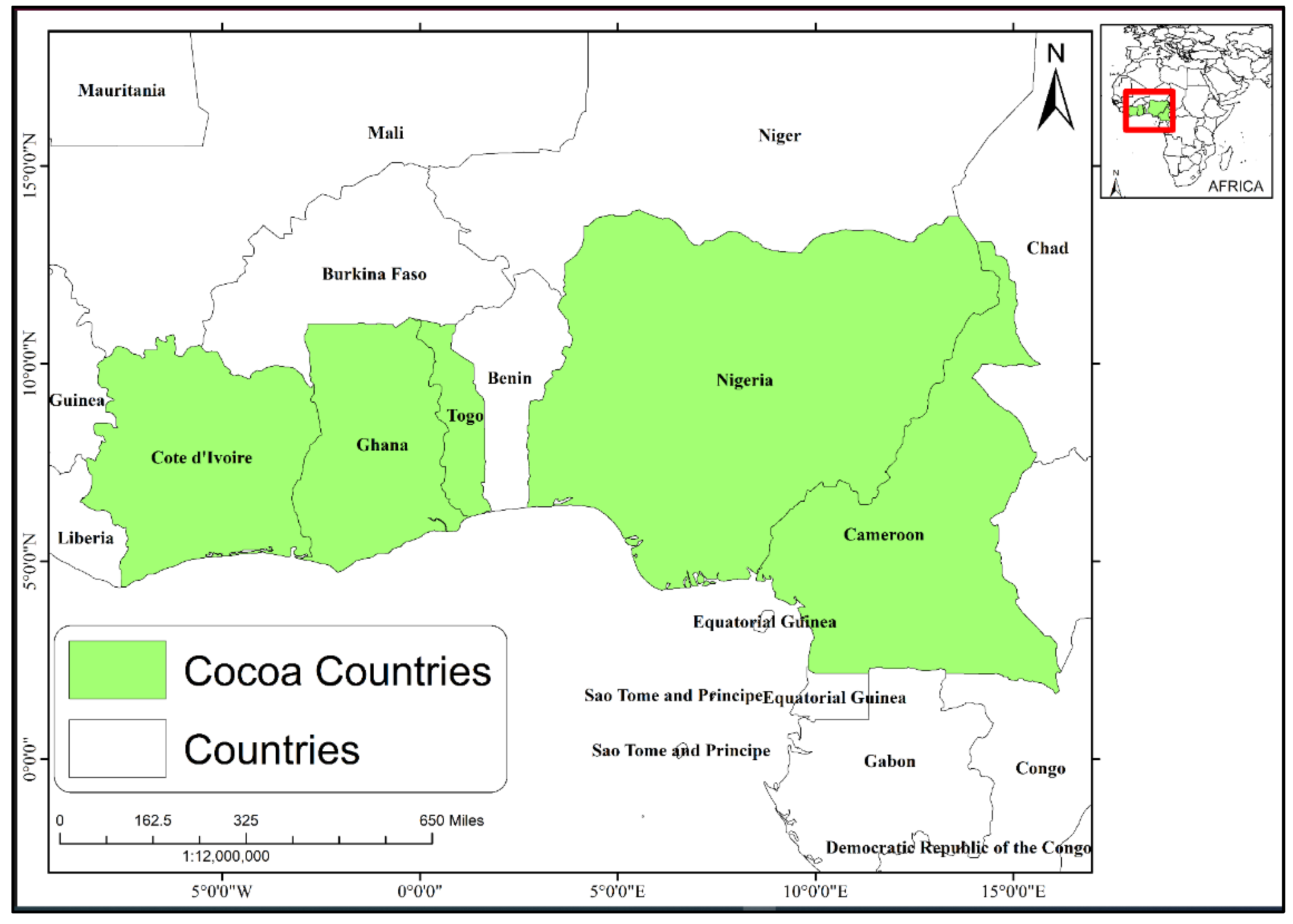
3. Production Capacities and Agronomic Constraints in West Africa

3.1. Regional Context and Comparative Overview

Cocoa production across West Africa underpins more than 70 % of global supply, yet the region continues to face stagnating yields, soil degradation, and climatic pressures. The five dominant producers, Côte d’Ivoire, Ghana, Nigeria, Cameroon, and Togo (Figure 1), illustrate distinct, yet converging trends of agronomic constraint and technological opportunity. Between 2000 and 2023, cocoa area expanded substantially, but productivity gains remained limited. These five systems therefore provide an ideal lens for examining the intersection of regenerative agriculture RA, UAS, and AI for precision-regenerative management.

3.2. Production Capacities and Agronomic Constraints of Major Producers

The five principal cocoa-producing nations, Côte d’Ivoire, Ghana, Nigeria, Cameroon, and Togo, exhibit distinct yet interrelated patterns of productivity shaped by ecological conditions, management practices, and institutional support. Each system faces unique agronomic constraints but also presents context-specific opportunities for regenerative and precision innovation. Table 2 provides a comparative overview of national production capacities, yield trends, and key constraints, together with the regenerative and technological opportunities that underpin precision-regenerative management across West Africa.

3.2.1. Côte d’Ivoire

Côte d’Ivoire remains the world’s largest cocoa producer, accounting for nearly 40 % of global output. While production expanded from roughly 1.3 million t in 2000 to more than 2.3 million t in 2023, yield per hectare has stagnated near 600–700 kg ha⁻¹ (Table 2). Long-term soil acidification (pH 6.2 - 5.4) nutrient depletion, and aging tree populations contribute to declining productivity despite improved hybrid availability. Recent regenerative interventions include large-scale agroforestry rehabilitation and targeted canopy mapping using UAS to optimize shade and soil–moisture relations.

3.2.2. Ghana

Ghana’s cocoa economy has historically benefited from strong institutional support but faces severe yield decline due to Cocoa Swollen Shoot Virus Disease (CSSVD), which has decimated over 200,000 ha since 2015. Yields, once exceeding 800 kg ha⁻¹ in the early 2000s, have fallen below 600 kg ha⁻¹ in many regions. Soil potassium deficiency (<0.25 cmol kg⁻¹) and low organic matter further exacerbate nutrient imbalances. Integrating compost-based soil restoration with UAS thermal monitoring for disease stress detection and AI-assisted nutrient mapping offers a scalable regenerative pathway.

3.2.3. Nigeria

Nigeria’s cocoa sector, though third in West Africa, reflects a contrasting trend: slow but steady expansion in cultivated area rather than per-hectare yield gains. Average yields hover around 500 kg ha⁻¹, constrained by minimal fertilizer use (<5 kg NPK ha⁻¹) and limited access to improved varieties. Fragmented smallholder structures hinder coordinated management, but emerging cooperative drone services and AI-based yield prediction models show promise for precision input targeting (Table 2).

3.2.4. Cameroon

Cameroon’s cocoa production system demonstrates high climatic sensitivity. Annual production fluctuates between 250,000 and 300,000 t, with yields oscillating from 400 to 600 kg ha⁻¹ in response to erratic rainfall patterns and land degradation. Poor pruning and inconsistent shade management further reduce photosynthetic efficiency. UAS-based precision irrigation and regenerative soil restoration practices, particularly compost mulching and carbon re-enrichment, are increasingly piloted to counteract these stresses.

3.2.5. Togo

Togo’s smallholder cocoa farms produce less than 100,000 t annually, yet their ecological challenges mirror regional trends. Soil erosion, nutrient depletion, and aging plantations limit yields to below 500 kg ha⁻¹. Rehabilitation through organic amendments, cover cropping, and drone-assisted soil mapping is gradually restoring productivity in pilot regenerative plots, demonstrating scalable solutions for marginal agroecosystems.

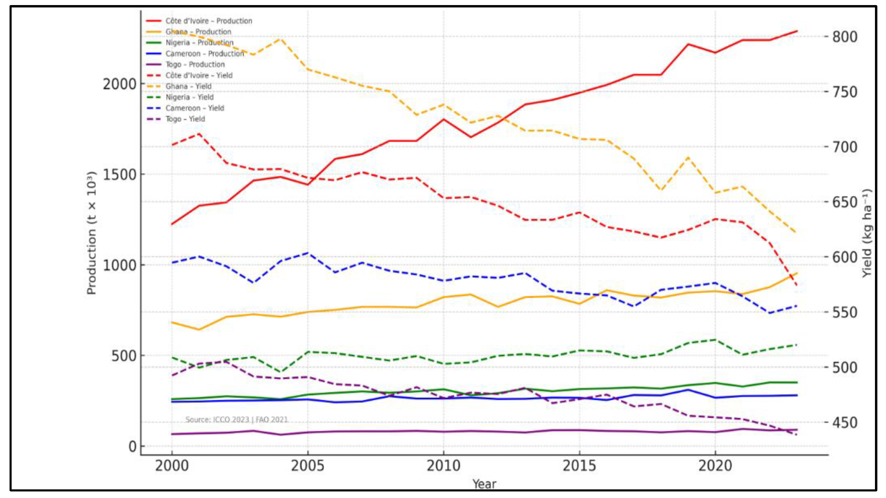
3.3. Long-Term Yield Dynamics and Structural Patterns (2000–2023)

Across the five principal producing countries, production increased from roughly 2.6 Mt in 2000 to nearly 3.9 Mt by 2023 (ICCO, 2023) (Figure 4), yet yields per hectare have largely stagnated.
The early 2000s witnessed modest gains linked to national fertilizer programs and favorable rainfall, but subsequent decades saw regression driven by aging tree populations, disease outbreaks, and climate variability. Figure 4 illustrates these long-term yield and production trajectories, highlighting sharp declines in Ghana and Côte d’Ivoire compared with relatively stable trends in Nigeria, Cameroon, and Togo.
Ghana’s yield, which peaked above 800 kg ha⁻¹ around 2008, has declined sharply due to CSSVD, while Côte d’Ivoire’s yield decreased from approximately 700 to 620 kg ha⁻¹, reflecting long-term soil acidification and canopy senescence. Nigeria’s consistent but low baseline (~500 kg ha⁻¹) masks significant intra-zonal variability, whereas Cameroon and Togo exhibit strong correlations between rainfall anomalies and output fluctuations.
These longitudinal patterns indicate that productivity gains have been driven more by land expansion than by yield improvement, a hallmark of extensive rather than intensive growth. This underscores the need for precision-regenerative frameworks that enhance input efficiency and soil resilience. The stagnation of yield per hectare, despite growing technological awareness, further highlights the urgency of developing site-specific diagnostics and adaptive management systems across ecological gradients as visualized in Figure 3.

3.4. Synthesis and Implications for Precision-Regenerative Management

The comparative analysis of production capacities and agronomic constraints across these five West African countries reveals systemic limitations—declining soil fertility, nutrient mining, disease pressure, and low input efficiency, that collectively impede yield improvement. These macro-level insights form the empirical foundation for the Conceptual Analytical Framework (Figure 3), which operationalizes the integration of RA, UAS, and AI to advance precision-regenerative cocoa management across heterogeneous agroecosystems.

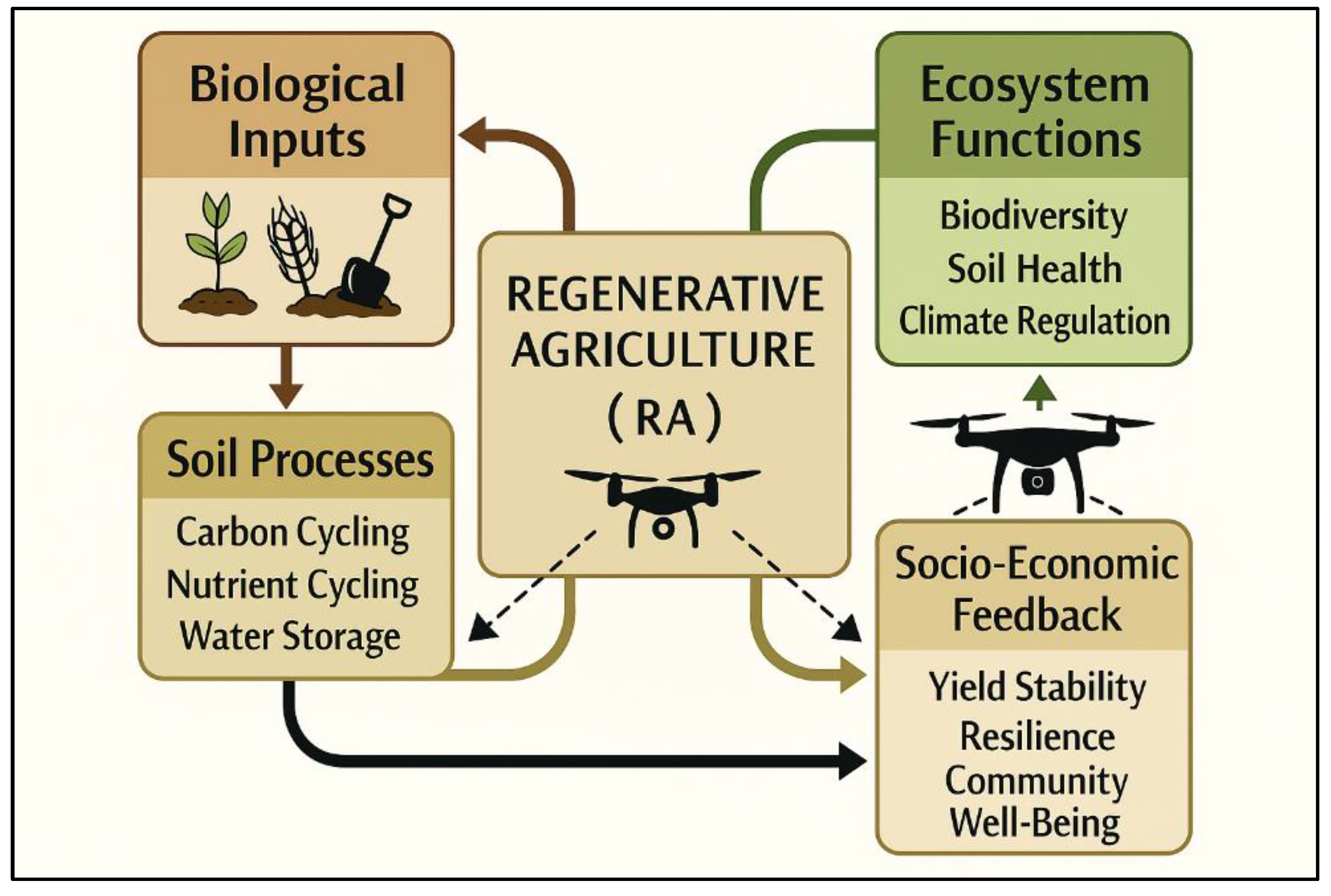
4. Regenerative Agriculture in Cocoa Production Systems

Serving as Axis I of the conceptual framework (Figure 3), RA constitutes the ecological foundation of the precision-regenerative management system, upon which the UAS) and AI layers are built. Regenerative agriculture restores the functional integrity of cocoa agro-ecosystems while maintaining economic viability. Rather than depending on input-intensive intensification, RA rebuilds soil organic matter, enhances nutrient cycling, and re-establishes biodiversity equilibrium across smallholder landscapes typically ranging from 2 to 5 ha [10,11,12,13,45,46,47].
Within West Africa, these practices have emerged as critical responses to declining soil fertility, nutrient mining, and climatic variability that jointly suppress yields and ecosystem resilience [48,49,50]. Regenerative agriculture thus provides the biophysical and socio-ecological base that enables precision-regenerative management across heterogeneous cocoa landscapes [19,81,82,83].

4.1. Core Principles and Systemic Role

At its foundation, RA emphasizes soil regeneration, biological diversity, and circular nutrient management. Its operational pillars, soil-health restoration, agroforestry integration, minimal disturbance, mulching, cover cropping, intercropping, and cooperative learning, function synergistically to re-establish ecosystem processes (Table 3). When implemented collectively, these practices enhance soil-water balance, carbon sequestration, and system stability [51,52,53,54,55,56].

4.2. Soil Health Restoration and Carbon Dynamics

Soil health regeneration anchors the regenerative approach. Composting of cocoa-pod husks, green manuring, and nitrogen-fixing cover crops (e.g., Mucuna pruriens, Crotalaria juncea) replenish organic carbon and stimulate microbial activity, improving cation-exchange capacity and nutrient retention [47,52,57]. Empirical evidence from Ghana indicates that systematic composting of pod husks increases soil organic carbon by about 20 % over three years and reduces fertilizer dependency by approximately 15 % [66,67,68]. These carbon gains buffer yield stability during drought periods and underpin long-term fertility recovery [70].

4.3. Agroforestry as the Structural Backbone

Agroforestry constitutes the architectural core of regenerative cocoa systems [55,69,70]. Multi-strata arrangements involving shade species such as Gliricidia sepium, Albizia lebbeck, and Terminalia superba moderate microclimate, reduce evapotranspiration, and foster nutrient cycling through litter deposition [71,72,73,74]. Quantitative assessments show shaded systems maintain yield stability under temperature anomalies where full-sun plantations experience 20–30 % reductions [75,76,77]. Beyond biophysical regulation, diversified agroforestry provides alternative income from timber, fruits, and non-timber products, enhancing livelihood resilience while preserving canopy heterogeneity crucial for pollinator networks [78].

4.4. Soil-Disturbance Minimization and Structural Integrity

Conservation tillage, central to RA, reduces mechanical disruption of soil aggregates, preserves microbial habitats, and maintains root-zone porosity [58,59,61]. Field trials demonstrate that reduced tillage increases soil-organic-carbon by almost 0.6 Mg ha⁻¹ yr⁻¹ and enhances infiltration and rooting depth [45,50]. These outcomes translate into improved water-holding capacity and seedling survival, directly reinforcing climate-resilience metrics used in sustainability assessments [62].

4.5. Mulching, Cover Cropping, and Nutrient Efficiency

Mulching with cocoa-pod residues or leaf litter stabilizes soil temperature, reduces evaporation, and suppresses weed competition [67,68]. When integrated with leguminous cover crops such as Pueraria phaseoloides and Mucuna pruriens, nutrient-use efficiency improves by approximately 25 % while chemical input requirements decline by 10–15 % [52,55,60]. The decomposition of surface residues increases labile organic carbon and nitrogen (N) pools, contributing to gradual soil-fertility enhancement [64]. NDVI-based field studies further confirm higher canopy vigor in mulched plots relative to conventional bare-soil management [81].

4.6. Biodiversity and Socio-Ecological Integration

Biodiversity enhancement represents both an ecological and socio-economic pillar of RA [54,55,70]. In Cameroon, regenerative plots exhibit approximately twice the species richness and 35 % greater macro-faunal abundance compared with conventional monocultures [56,58]. These ecological gains are reinforced through cooperative and certification initiatives that institutionalize sustainable practices [47,63,74]. Participatory composting programs, training networks, and shared nurseries accelerate adoption, while certification mechanisms monetize ecological services and improve market access [9,11].

4.7. Quantified Outcomes and Conceptual Integration

Across compiled case studies, RA-managed cocoa soils exhibit 25–40 % higher organic-matter content, 15–20 % greater field-capacity water retention, and more balanced pH relative to conventionally managed soils [11,46,57]. These biophysical improvements confirm the regenerative model as a viable pathway toward climate-resilient intensification [70,72] and justify its placement as Axis I within the broader RA–UAS–AI framework [81,82,83,120].

4.8. Bridging to Technological Harnessing

The regenerative principles outlined above provide the ecological substrate upon which precision technologies can operate effectively. By restoring soil health, enhancing canopy structure, and stabilizing microclimates, regenerative agriculture establishes the baseline biophysical integrity necessary for high-resolution monitoring and data-driven management. The subsequent section (Section 5) demonstrates how UAS and AI harness these regenerative processes, translating soil and canopy dynamics into quantifiable indicators for adaptive cocoa management [81,82,83,120,121,122,123,124,125].
Figure 5 conceptualizes RA as an interactive network linking biological inputs, soil processes, ecosystem functions, and socio-economic feedback. Biological inputs such as cover crops, compost, and organic residues drive soil processes that enhance nutrient and carbon cycling, soil aggregation, and water storage. These improvements strengthen ecosystem functions, including biodiversity, soil fertility, and climate regulation, which, in turn, generate socio-economic outcomes such as yield stability, resilience, and livelihood enhancement. The central integration of RA, supported by UAS-based spatial monitoring (symbolized by drones), facilitates continuous assessment and optimization across biophysical and socio-economic dimensions.
As illustrated in Figure 5, the ecological foundation established through regenerative agriculture provides the functional basis for UAS-enabled precision diagnostics. By restoring soil structure, organic matter, and biological balance, regenerative practices create the stable biophysical conditions necessary for meaningful spatial assessment. Within this context, UAS technologies quantify variability in canopy vigor, soil moisture, and microclimate, translating ecological restoration into measurable, site-specific indicators. These diagnostics guide adaptive management interventions—such as targeted composting, irrigation scheduling, or shade regulation—linking ecological function with precision management outcomes. The operational applications of these diagnostics are elaborated in Section 5.

5. Unmanned Aerial Systems for Spatial Diagnostics and Regenerative Management

Serving as Axis II of the conceptual framework (Figure 3), the UAS component operationalizes the spatial dimension of precision-regenerative cocoa management. Building upon the ecological foundations established under Axis I (RA), this axis employs multispectral, thermal, and LiDAR-based sensing to characterize canopy vigor, soil–water status, and structural variability at sub-field resolution [19,60,78,79,80,81,82,83]. Through repeated temporal acquisitions and AI-assisted image analytics, UAS platforms enable researchers and farmers to detect stress gradients, quantify spatial heterogeneity, and guide site-specific regenerative interventions such as targeted composting, mulching, pruning, and shade optimization [81,82,83,120,121,122,123].
The following subsections (5.1–5.4) synthesize the analytical dimensions of UAS-based diagnostics in cocoa systems: (i) spectral indices and canopy vigor; (ii) multispectral-thermal synergies; (iii) LiDAR-derived structural metrics; and (iv) integrated adaptive surveillance.

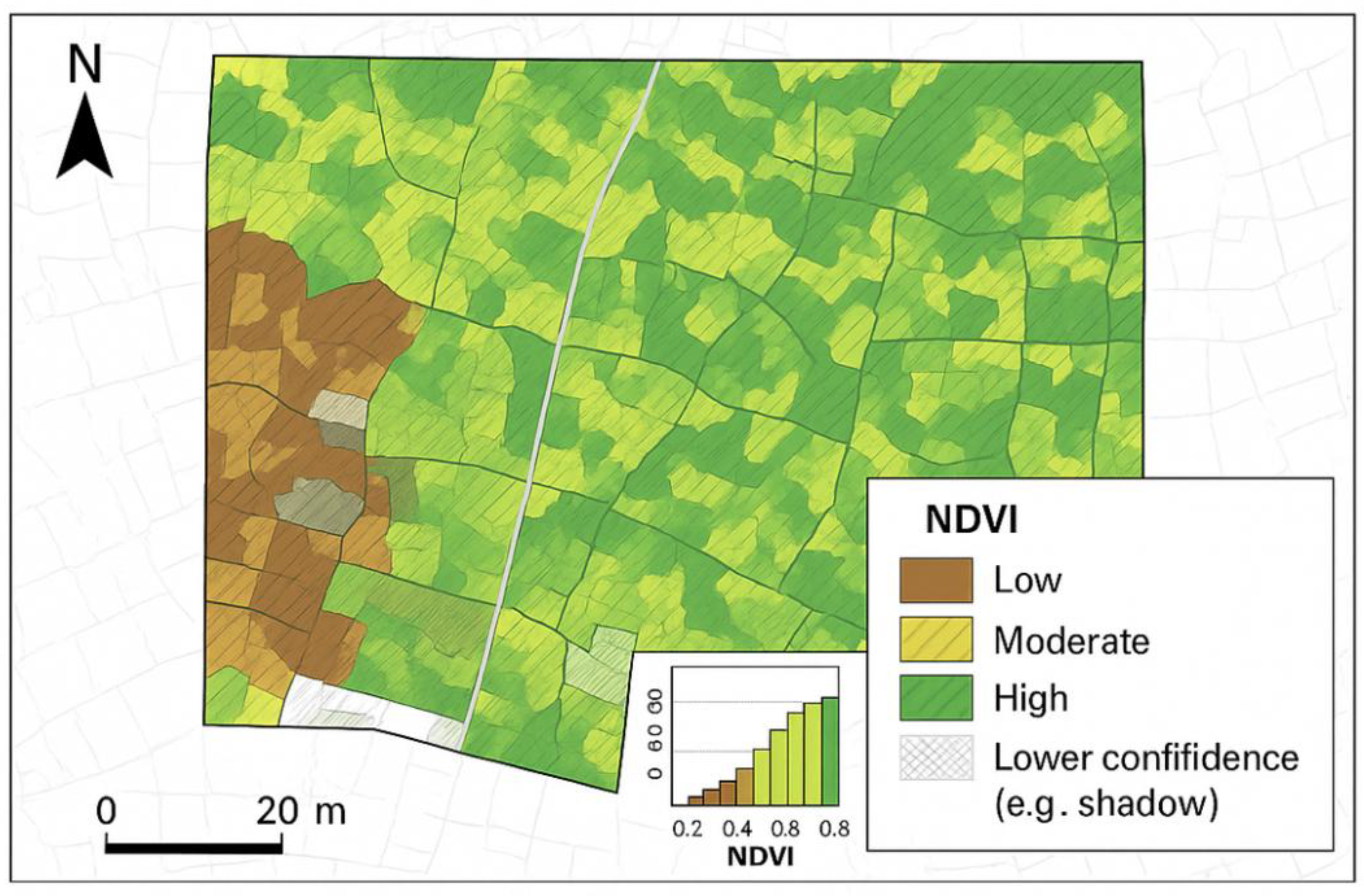
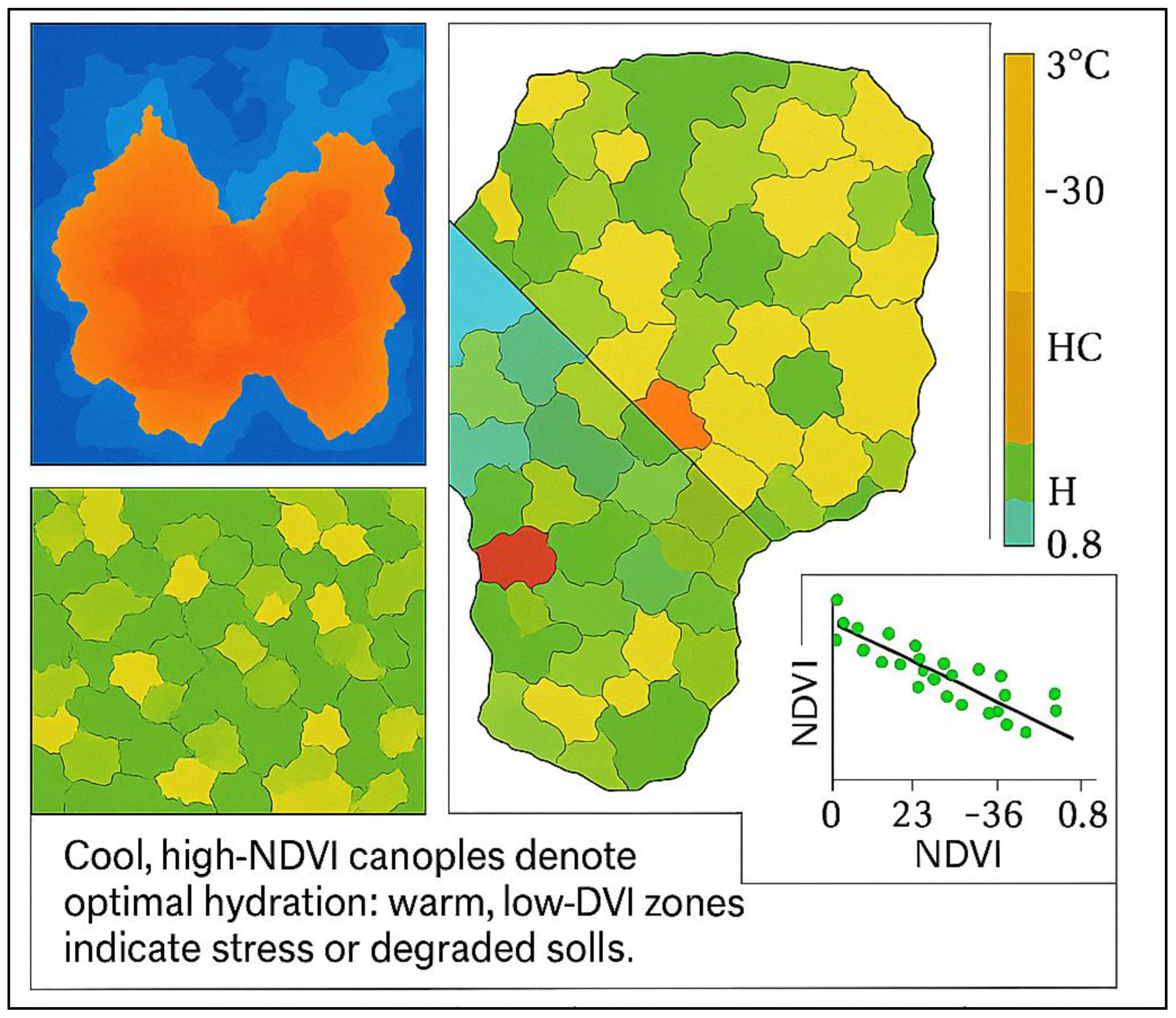
5.1. Spectral Indices and Canopy Vigor Diagnostics

Across West African cocoa systems, UAS equipped with multispectral sensors provide rapid, non-destructive quantification of canopy vigor and spatial variability. Indices such as the Normalized Difference Vegetation Index (NDVI), Enhanced Vegetation Index (EVI), and Soil-Adjusted Vegetation Index (SAVI) remain among the most robust proxies for cocoa vigor and chlorophyll content, with coefficients of determination (R² ≈ 0.70–0.85) relative to ground-measured leaf-area index and foliar N [81,82,83,84,85].
Figure 6 illustrates NDVI-based canopy-vigor classes within cocoa fields, identifying high-, medium-, and low-vigor zones that correspond to differences in soil fertility, shading, and pest incidence.
These spatial diagnostics enable site-specific interventions—such as differential pruning or nutrient supplementation—thus strengthening both productivity and ecological resilience.

5.2. Multispectral–Thermal Synergies

Thermal sensing complements spectral diagnostics by quantifying canopy-temperature dynamics that reflect plant water status and energy balance. In cocoa landscapes, canopy temperature is a direct proxy for transpiration rate and stomatal conductance—two parameters that strongly respond to moisture stress and nutrient imbalance [89,90,91,92]. Integrating thermal imagery with NDVI and other spectral indices thus enables concurrent assessment of vegetation vigor and water use efficiency.
Across Ghanaian and Cameroonian cocoa farms, studies show that canopy-temperature differentials of just 1–2 °C correspond to 10–15 % variation in soil-moisture content, emphasizing the sensitivity of UAS thermal imagery for early drought detection [90,91,92,93]. When overlain with NDVI layers, warm canopies (typically in low-NDVI zones) signify water stress or nutrient deficiency, whereas cooler canopies correspond to vigorous, well-hydrated trees.
Beyond stress mapping, thermal data improves the interpretation of canopy heterogeneity caused by topography and shade distribution (Figure 7).
Coupled multispectral–thermal mosaics can isolate micro-zones where heat retention signals compacted soil, poor drainage, or inadequate mulch cover. Such insights support regenerative actions like targeted mulching, shade optimization, and moisture-conserving contour composting.
Processing thermal–NDVI composites through AI models such as Random Forests or CNNs enhances pattern recognition accuracy and allows temporal trend analysis, identifying recurrent “hotspots” of stress through the growing season. These outputs form early-warning dashboards for adaptive intervention, improving water management and climate resilience within precision-regenerative cocoa systems.

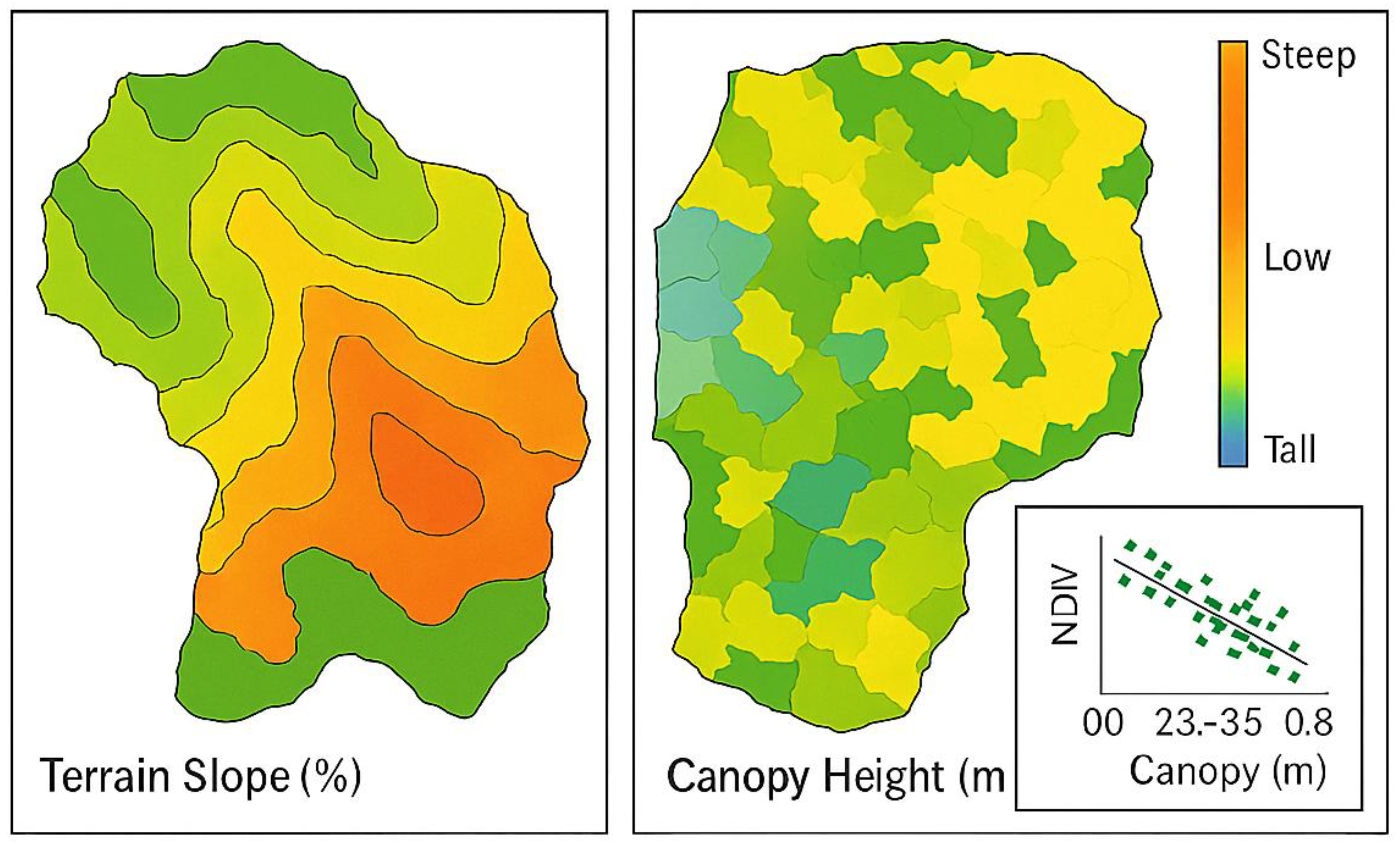
5.3. LiDAR-Based Structural and Terrain Diagnostics

When integrated with NDVI and thermal datasets, Light Detection and Ranging (LiDAR) provides a three-dimensional diagnostic layer that substantially enhances site-specific management in cocoa agroecosystems. Unlike purely spectral indices that capture surface reflectance, LiDAR penetrates the canopy to deliver vertical structural information, mapping canopy height, foliage density, and understorey heterogeneity with centimeter-level precision. This multi-dimensional capacity enables fine-scale delineation of cocoa shade patterns, crown volume, and gap fractions—key determinants of vigor, microclimate regulation, and pest–disease vulnerability [92,93].
In West African cocoa systems, LiDAR-derived digital elevation models (DEMs) and canopy-height models (CHMs) are instrumental in terrain analysis, erosion-risk mapping, and drainage optimization. By quantifying slope, aspect, and elevation variability, LiDAR data help identify low-lying waterlogged zones versus erosion-prone uplands, guiding regenerative interventions such as contour planting, mulching, and strategic agroforestry layout. When fused with NDVI and thermal imagery, the result is a composite spatial intelligence layer that distinguishes healthy canopies, degraded understories, and compacted soils—essential inputs for targeted composting, pruning, and enrichment planting (Figure 8).
When integrated with NDVI and thermal datasets, LiDAR outputs provide a three-dimensional diagnostic layer that enhances site-specific management. This integration supports spatially explicit pruning, enrichment planting, and agroforestry optimization, strengthening both productivity and ecosystem resilience [92,93]. Moreover, LiDAR enables precise estimation of above-ground biomass and carbon stocks, supplying quantitative benchmarks for evaluating regenerative outcomes and informing AI-driven yield and carbon-sequestration models [94,95,96].
Collectively, these capabilities establish LiDAR as a cornerstone of the precision-regenerative framework, bridging canopy structure, terrain morphology, and predictive intelligence to guide sustainable cocoa-system transformation.

5.4. Integrated Insights and Adaptive Surveillance

Time-series UAS acquisitions that combine NDVI, multispectral, thermal, and LiDAR layers enable multidimensional monitoring of cocoa agroecosystems [80,85]. These integrated datasets improve stress detection accuracy (> 85 %) when processed through AI classifiers such as Convolutional Neural Networks (CNNs) or Random Forests [120,121,122,123]. Beyond diagnostics, UAS–AI integration supports real-time adaptive management: for example, AI-interpreted NDVI–LiDAR composites can trigger localized recommendations for pruning, mulching, or shade adjustment [124,125,126,127].
Cooperative drone-service models in Ghana and Nigeria further demonstrate that locally trained operators can deliver high-frequency mapping at < US$5 ha⁻¹, democratizing access to precision-regenerative tools [82,83].
In summary, UAS-derived spectral and structural analytics provide a robust foundation for precision-guided regenerative cocoa farming. NDVI and multispectral indices deliver rapid physiological diagnostics, LiDAR captures canopy and terrain architecture, and AI algorithms convert these multidimensional datasets into actionable intelligence (see Section 6). This fusion of tools enables climate-resilient, resource-efficient management across heterogeneous West African cocoa landscapes.

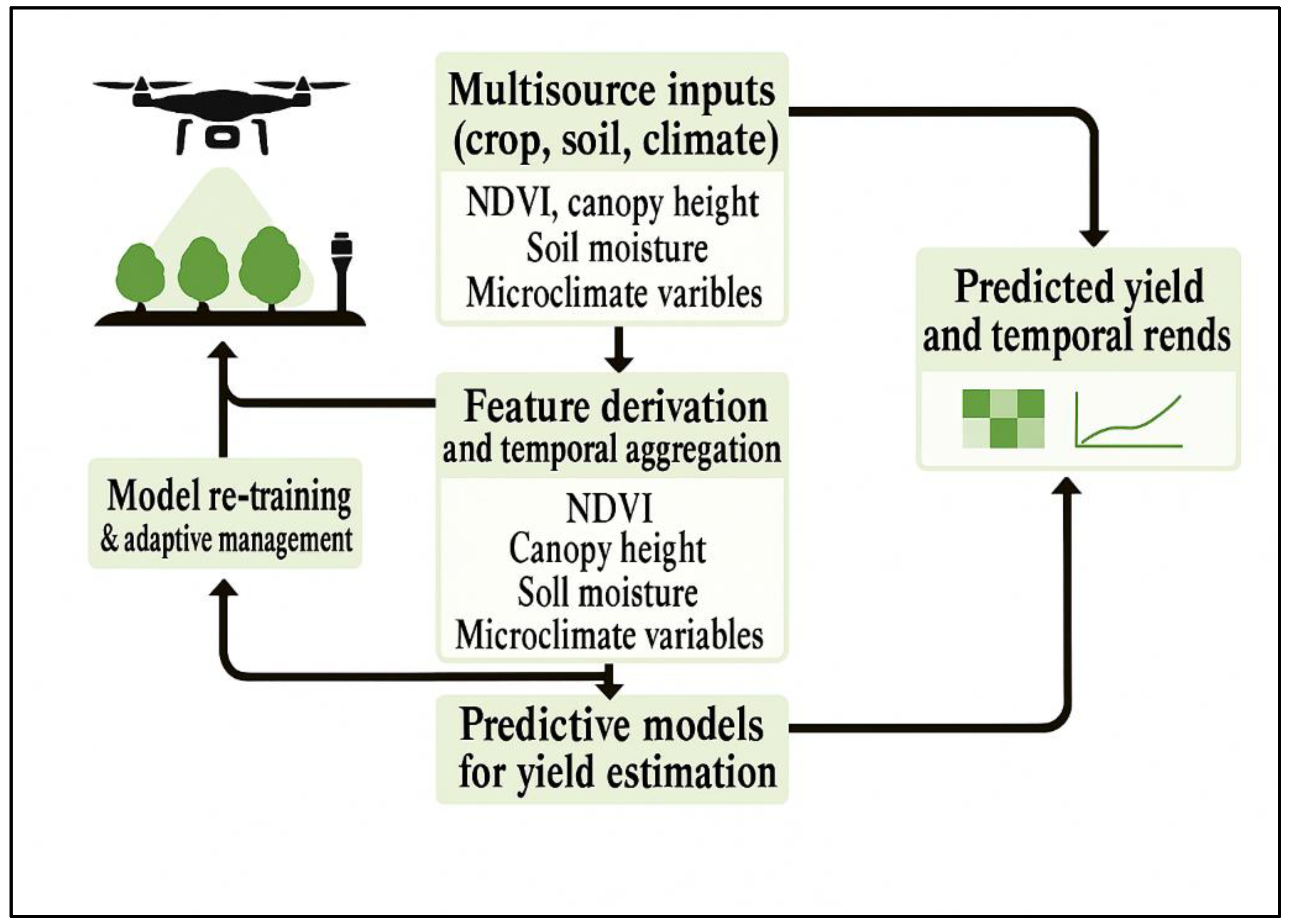
6. Artificial Intelligence for Predictive Modeling and Decision Support (Axis III)

Serving as Axis III of the analytical framework (Figure 2), this section advances the integration of AI as the predictive and decision-support tier of precision-regenerative cocoa management (Figure 9). Building upon the biophysical foundations established under Axis I (Regenerative Agriculture) and the spatial diagnostics from Axis II (UAS-based mapping), AI transforms spectral and structural datasets into actionable agronomic intelligence. Through machine- and deep-learning architectures, Axis III operationalizes classification, yield prediction, stress detection, and decision-support integration, linking data-driven insights directly to regenerative field actions (Figure 9).
This figure illustrates the hierarchical data flow from Axis I (Regenerative Agriculture) through Axis II (UAS-based spatial diagnostics) into Axis III (AI-driven predictive systems), forming an adaptive regenerative feedback loop that integrates soil health, spatial variability, and intelligent decision support.
The integration of AI with UAS-derived spectral and structural datasets represents the analytical frontier of precision and regenerative cocoa management. Building upon the spectral (NDVI, multispectral, thermal) and structural (LiDAR) layers discussed in Section 5, AI transforms these raw data streams into predictive agronomic intelligence capable of guiding site-specific regenerative interventions. Machine, and deep-learning frameworks now enable the fusion of spectral vigor indices, canopy-height models, and environmental covariates into real-time decision pipelines that support climate-resilient, low-input cocoa systems [120,121,122,123]. AI applications fall into four synergistic domains, classification and detection, yield estimation, stress mapping, and decision-support integration, each contributing to data-driven regenerative practice optimization.

6.1. Classification and Detection

AI-based classification extends UAS diagnostics beyond descriptive mapping toward prescriptive intelligence. Convolutional Neural Networks trained on RGB, multispectral, and thermal imagery have been shown to identify early nutrient deficiency, pest incidence, and canopy-disease symptoms with accuracies exceeding 90 % [120,121,122,123]. Hybrid CNN–Random Forest (RF) architectures further enhance robustness under variable illumination and shadowing, outperforming single-model approaches by 5–10 % [124].
Recent applications of machine, and deep-learning models in cocoa systems across West Africa demonstrate strong potential for site-specific classification of canopy vigor, disease, and nutrient stress [125,126,127,145] (Table 4). These algorithms transform UAS-derived imagery into actionable field intelligence, bridging the gap between precision diagnostics and regenerative intervention.
Applied within RA frameworks, these models enable timely interventions such as targeted compost application, shade adjustment, and organic pest control, actions consistent with regenerative principles and aimed at minimizing synthetic-input use. By combining spectral and thermal data with advanced classification techniques, cocoa farms can transition from reactive management to predictive, ecologically grounded decision-making.

6.2. Yield Estimation and Prediction

Predictive modeling combines UAS-derived NDVI, canopy structure, and soil data to forecast yield potential under varying climatic regimes (Figure 10). Random Forest and Gradient Boosting Machines (GBM) capture non-linear relationships between canopy vigor and productivity (R² = 0.68–0.82) [125,126]. Temporal deep-learning architecture such as Long Short-Term Memory (LSTM) networks leverage multi-season NDVI and rainfall series to explain up to 85 % of yield variance [127]. By translating canopy and soil signals into predictive yield maps, these models ensure that regenerative inputs, compost, biofertilizers, irrigation, are directed to the most responsive zones, improving both efficiency and sustainability.
The diagram illustrates data integration from UAS-derived spectral and structural variables (NDVI, canopy height, soil moisture, and microclimate parameters) into AI-based predictive models. Outputs include yield forecasts and temporal trends that inform adaptive regenerative management through model re-training. Created with AI-assisted conceptual synthesis; illustrative only, not derived from empirical data.
In West Africa, several machine- and deep-learning frameworks have been adapted for cocoa analytics, integrating multisource UAS and environmental datasets into predictive and diagnostic pipelines. Table 5 summarizes the principal AI architectures, their input requirements, output functions, and demonstrated or potential applications across the subregion [120,121,122,123,124,125,126,127,128,129,130].

6.3. Stress Detection and Risk Mapping

Integrated stress-mapping frameworks fuse NDVI, canopy-temperature, LiDAR, and precipitation layers to locate emerging physiological or environmental constraints [128,129] as illustrated in Figure 11.
Figure 11. Workflow for cocoa-yield estimation and prediction using multisource UAS data and AI algorithms. Data streams from spectral, structural, and climatic inputs are fused for adaptive yield forecasting.
Preprints 185125 g011
Convolutional Long Short-Term Memory (LSTM) and Temporal Convolutional Network (TCN) architectures produce spatial probability surfaces of nutrient, moisture, and disease stress with accuracies exceeding 85 %. When coupled with climate forecasts, these models generate dynamic risk indices that enable proactive regenerative actions such as mulching, cover-cropping, or micro-shade establishment before yield loss occurs [128,129,130].
To operationalize this process, data acquisition begins with UAS-based measurements of canopy vigor (NDVI), temperature differentials (thermal imaging), canopy structure (LiDAR), and rainfall time-series data. These layers are processed through AI modeling frameworks, principally LSTM and TCN networks, that capture temporal dynamics and predict stress probability distributions. The resulting decision-support outputs, including nutrient-stress maps and regenerative intervention plans, guide adaptive field management in near real time. This workflow closes the feedback loop between spatial diagnostics and regenerative decision-making, allowing site-specific responses that enhance soil health, canopy resilience, and input-use efficiency [129,130,131].
Building on these adaptive analytics, Section 6.4 expands the framework into AI-driven decision-support systems that translate stress maps and predictive indicators into field-level advisories. By integrating real-time UAS data streams with localized recommendations, these systems empower cocoa cooperatives and farmers to implement regenerative interventions dynamically, aligning technological precision with ecological restoration.

6.4. Decision-Support and Regenerative Integration

AI-driven decision-support systems convert analytical outputs into field-ready advisories. Cloud dashboards and mobile applications integrate spectral anomalies, stress probabilities, and yield forecasts into localized recommendations for composting, pruning, or shade regulation [130]. Language-adapted dashboards and voice interfaces enhance accessibility for cooperatives and smallholders, translating high-resolution analytics into actionable regenerative decisions that balance productivity with ecological integrity.

6.5. Research and Development Priorities

Advancing AI integration within precision-regenerative cocoa systems requires three interlinked priorities tailored to West African contexts.
(1) Localized datasets: Develop region-specific, phenology-calibrated datasets that integrate multi-season UAS, satellite, and field data to capture spectral and structural variability across cocoa ecotypes. These datasets will enhance the sensitivity of AI models to local canopy dynamics, nutrient status, and climatic variability.
(2) Model transferability: Strengthen model generalization across soil types, canopy structures, and agro-ecological zones by conducting comparative validations through national research programs and cooperative datasets. Such calibration ensures robustness under differing management and landscape conditions.
(3) Open analytical ecosystems: Establish open-source, interoperable AI pipelines that promote transparency and collaborative innovation. Co-development with universities, research institutes, and farmer cooperatives will build regional digital capacity and ensure equitable access to analytical tools.
Integrating AI-derived metrics, soil-organic-carbon change, canopy vigor, biodiversity indices, and microclimate stability, into regenerative monitoring protocols will allow quantifiable sustainability assessments across temporal and spatial scales. These indicators create the foundation for performance-based incentives such as carbon-credit valuation and ecosystem-service payments, linking scientific data to tangible farmer benefits.

6.6. Policy and Institutional Implications

Embedding the RA–UAS–AI framework into national cocoa strategies requires coordinated governance that aligns technological, institutional, and financial systems. Extension networks, public–private partnerships, and digital cooperatives must collaborate to translate analytics into actionable guidance for smallholders. Subsidized drone cooperatives and clear data-governance policies will democratize technology access while protecting farmer data rights and intellectual property.
Investment in digital-literacy training for youth, extension agents, and farmer organizations will expand their capacity to interpret AI-derived advisories and integrate them into field decisions. Governments and development partners can further accelerate adoption by linking regenerative outcomes—carbon sequestration, biodiversity gains, soil fertility recovery, to verified sustainability credits and certification schemes, aligning local incentives with global goals such as the Paris Agreement and SDGs 13 and 15.
Establishing inclusive, transparent institutions for data management and ethical AI deployment will ensure that digital transformation reinforces rather than replaces traditional agronomic knowledge. In doing so, policy frameworks will not only scale precision-regenerative technologies but also empower farmers as co-creators of sustainable cocoa systems across West Africa.
To operationalize this research, institutional, and policy dimensions, actionable pathways are required to link innovation with implementation. Table 6 synthesizes the priority actions, expected outcomes, and indicative timelines needed to consolidate AI-enabled precision-regenerative cocoa systems across West Africa.

7. Case Studies and Applications Across West Africa

Empirical evidence across West Africa confirms that the integration of RA, UAS, and AI delivers measurable improvements in productivity, ecosystem health, and livelihood resilience [134,135,136]. The following country-level case studies illustrate how each analytical axis—ecological regeneration, spatial diagnostics, and predictive modeling—interacts within real-world cocoa landscapes to optimize management, enhance decision precision, and advance sustainability objectives.

7.1. Côte d’Ivoire

Côte d’Ivoire, the world’s largest cocoa producer, has implemented UAS–AI agroforestry monitoring systems to support carbon verification and certification programs. CNN-based segmentation models quantified shade cover and species composition with approximately 93 % accuracy, validating the ecological performance of mixed-species regenerative plots [137,138]. Shaded cocoa systems (30–40 % canopy cover) sequestered 25–30 t C ha⁻¹ more carbon than full-sun plantations, while integrated regenerative practices increased soil-organic-carbon (SOC) by roughly 18 % within three years [138].
These outcomes confirm the dual value of AI-assisted UAS analytics, providing both productivity verification and ecosystem-service accounting within sustainability and certification frameworks.

7.2. Ghana

In Ghana, the Cocoa Health and Extension Division (CHED) of COCOBOD piloted multispectral UAS monitoring within regenerative demonstration plots in the Ashanti and Western Regions. NDVI and canopy-temperature maps derived from eBee X flights guided precision compost and mulch placement, resulting in 15–22 % yield increases across two growing seasons [134].
Thermal–NDVI fusion analysis identified localized moisture stress zones, enabling targeted shade-tree enrichment that lowered canopy temperature by up to 2 °C [135]. AI-based yield-forecast dashboards provided adaptive scheduling for pruning and organic nutrient management.
Youth-operated cooperative drone services, developed through university partnerships, have reduced mapping costs to under US $ 5 ha⁻¹, expanding access to precision tools and reinforcing inclusive, locally managed digital agriculture ecosystems [Pretty & Bharucha, 2014

7.3. Cameroon

In Cameroon, LiDAR-based terrain and canopy models are used for regenerative soil and water conservation planning. Topography-guided contour composting and residue barriers have reduced soil erosion by almost 40 %, while Gradient-Boosted Regression Tree (GBRT) models combining NDVI and slope metrics predicted yield with R² = 0.76 [141,142]. These applications illustrate how terrain–canopy integration enhances site-specific regenerative interventions, particularly in erosion-prone, high-rainfall environments.
Collaborative partnerships between research institutes and farmer cooperatives have strengthened local capacity for drone-data interpretation and adaptive regenerative planning, enabling community-led innovation.

7.4. Togo

In Togo, smallholder cooperatives have adopted low-cost quadcopters and open-source AI pipelines to monitor canopy vigor and track regenerative progress. Multispectral classification achieved 85–88 % accuracy in mapping shade distribution and canopy density [143]. The resulting maps guided precision compost placement and cover-crop seeding, reducing fertilizer waste by 10–15 % and increasing young-tree survival rates by approximately 20 %. Partnerships with NGOs and community-based organizations have embedded gender-inclusive training and local capacity-building, ensuring that technological adoption reinforces both social and environmental sustainability

7.5. Cross-Country Synthesis

Across the five principal cocoa-producing countries, the RA–UAS–AI triad has produced consistent agronomic and ecological gains, summarized in Table 7.
This table synthesizes the comparative agronomic and ecological outcomes of the RA–UAS–AI integration across the five principal cocoa-producing countries in West Africa—Côte d’Ivoire, Ghana, Nigeria, Cameroon, and Togo. The results demonstrate a consistent pattern of measurable improvements in yield, soil organic carbon (SOC), and predictive model accuracy, validating the framework’s scalability and cross-context adaptability.
In Côte d’Ivoire, canopy-height and carbon-accounting analytics derived from LiDAR and multispectral data increased yields by 18–25% while enhancing SOC by 18%, reflecting significant gains in both productivity and ecosystem carbon sequestration. Ghana’s NDVI-guided compost and mulch placement achieved comparable benefits, with 15–22% yield gains and a 20% rise in SOC, supported by model accuracies approaching 90%.
Nigeria exhibited the strongest AI-driven response, where convolutional neural network (CNN) and random forest (RF) classifiers improved early disease detection, boosting yield by 20–25% and maintaining predictive accuracies above 90%. In Cameroon, terrain-based soil–water management informed by LiDAR improved slope stability and hydrological balance, resulting in 10–20% yield gains and a 15% SOC increase despite lower model accuracies (≈76%), primarily due to complex topography. Finally, Togo’s cooperative open-source canopy monitoring systems achieved moderate yield improvements (10–15%) but the highest relative SOC enhancement (+20%), emphasizing the social and participatory dimensions of regenerative scaling.
Collectively, these results confirm that the RA–UAS–AI triad consistently enhances agronomic performance, soil health, and data-driven precision across heterogeneous production landscapes. The outcomes underscore the importance of local adaptation—leveraging context-specific sensing tools, participatory data systems, and regenerative practices—to achieve sustainable cocoa intensification at the regional scale.

7.6. Key Insights

  • Synergy Across Scales: Integrating ecological practices (RA) with high-resolution spatial diagnostics (UAS) and predictive modeling (AI) enables scalable precision management, even across highly heterogeneous landscapes.
  • Socio-Technical Empowerment: Cooperative drone networks and youth-led data hubs reduce technological barriers, strengthen local innovation ecosystems, and ensure inclusive participation.
  • Quantified Sustainability: Tangible improvements in SOC, canopy vigor, and yield demonstrate measurable ecological and economic benefits, supporting climate-smart certification and carbon-credit initiatives.
Collectively, these field-based applications validate the operational feasibility and scalability of precision-regenerative cocoa management. They form the empirical bridge to the cross-axis synthesis discussed in Section 8, where ecological, technological, and institutional dimensions converge to shape regional strategies for sustainable intensification.

8. Cross-Axis Integration and Strategic Implications

8.1. Introductory Context

Building upon empirical applications detailed in Section 7, this section synthesizes the cross-axis relationships among RA, UAS, and AI. The integration of these three analytical axes represents a convergent framework for sustainable cocoa production in West Africa, one that fuses ecological restoration (Axis I), spatial diagnostics (Axis II), and predictive intelligence (Axis III) into a unified precision-regenerative model (Figure 9).
Each axis contributes a distinct yet complementary function: RA rebuilds soil fertility and biodiversity; UAS spatially characterizes field heterogeneity and stress gradients; and AI transforms multisource data into predictive and adaptive intelligence.
Together, these axes enable a multidimensional management system that enhances productivity, ecosystem resilience, and social inclusivity.

8.2. Synergistic Outcomes Across the Three Axes

Cross-axis integration generates measurable synergies by aligning ecological functions with technological precision. Regenerative practices informed by UAS analytics and optimized through AI decision-support systems yield more efficient input allocation, higher yield stability (15–25 %), and reduced fertilizer usage (10–20 %) compared with conventional management [45,81,125].
UAS-derived vegetation indices such as NDVI and thermal data identify spatial variability in canopy vigor and microclimate, while AI-driven models predict nutrient or moisture stress zones that require targeted regenerative interventions. This ecological–technological coupling creates a closed feedback system in which field-level variability is continuously monitored, interpreted, and corrected—translating data-driven insights into tangible soil and crop improvements.

8.3. Ecosystem and Climate-Resilience Impacts

Cross-axis integration directly supports ecosystem restoration and climate adaptation. Regenerative practices—composting, mulching, cover cropping, and agroforestry—enhance soil-water retention, organic-carbon accumulation, and biodiversity recovery.
When guided by UAS–AI analytics, these interventions can be spatially optimized: high-resolution NDVI and LiDAR canopy models locate degraded zones for targeted restoration, while thermal indices inform microclimate regulation through shade management.
For instance, shaded agroforestry systems in Ghana and Côte d’Ivoire, mapped using UAS-derived NDVI composites, have demonstrated higher soil organic carbon stocks and lower canopy-temperature variance during dry seasons [71,74,92].
Moreover, AI-assisted carbon modeling linked with LiDAR-based biomass estimation strengthens the quantification of ecosystem services, enabling verified carbon accounting and participation in carbon-credit and regenerative-certification schemes.
Collectively, these improvements advance several Sustainable Development Goals (SDGs), particularly SDG 13 (Climate Action), SDG 15 (Life on Land), and SDG 12 (Responsible Consumption and Production).

8.4. Digital Inclusion and Knowledge Co-Production

The success of the RA–UAS–AI framework depends on inclusive digital participation and co-production of knowledge. Emerging cooperative drone networks and AI-enabled dashboards have facilitated farmer-led data collection, interpretation, and adaptive decision-making.
Voice-based and mobile interfaces democratize data access, allowing non-literate users to engage directly with spatial diagnostics and management recommendations.
By embedding digital literacy programs within cooperative structures, these initiatives foster gender equity, youth employment, and collective innovation in rural communities.
Furthermore, collaborative design among research institutions, extension agents, and farmers ensures that technological tools remain contextually relevant, culturally appropriate, and environmentally sustainable.
Institutionalizing data ethics and AI governance, including privacy safeguards, consent protocols, and transparent algorithmic auditing, will be essential to maintain farmer trust and equitable participation in emerging data economies [128,130,133].

8.5. Challenges and Research Frontiers

Despite its potential, the precision-regenerative framework faces several operational and institutional challenges:
  • Cost and Infrastructure: High deployment costs for UAS operations, limited cloud infrastructure, and inconsistent broadband access constrain data transmission and real-time analytics.
  • Model Generalization: Variability in canopy architecture, soil heterogeneity, and local microclimates limit the transferability of AI models across agroecological zones.
  • Data Fragmentation: Absence of standardized geospatial data protocols and regional data-sharing platforms impedes collaborative research and reproducibility.
Addressing these barriers requires investment in open-source analytical ecosystems, region-specific training datasets, and hybrid modeling approaches that integrate hyperspectral, soil-microbiome, and long-term climatic data to enhance prediction robustness.
Cross-border collaboration among West African research institutions, supported by harmonized data governance frameworks, will ensure scalability and equitable innovation diffusion.
Ultimately, overcoming these constraints will accelerate the transition from proof-of-concept pilots to large-scale regenerative transformation, bridging the gap between scientific innovation and field-level sustainability.

9. Conclusions and Strategic Recommendations

This review demonstrates that the integration of Regenerative Agriculture (RA), Unmanned Aerial Systems (UAS), and Artificial Intelligence (AI) provides a transformative pathway toward sustainable, resilient, and inclusive cocoa production systems across West Africa. Synthesizing ecological, technological, and socio-economic dimensions confirms that this triadic framework bridges productivity enhancement, environmental stewardship, and livelihood improvement, redefining how smallholder cocoa landscapes are monitored and managed.

9.1. Regenerative Foundations

At its ecological core, RA restores the biophysical integrity of cocoa systems by rebuilding soil organic carbon, enhancing nutrient cycling, and stabilizing microclimates. When these regenerative interventions are spatially guided by UAS and dynamically optimized through AI, management becomes both adaptive and precise. Empirical data across West Africa reveal that regenerative cocoa systems supported by UAS–AI analytics achieve:
  • 15–25 % higher soil-organic-carbon content,
  • 12–28 % yield gains, and
  • up to 20 % reductions in fertilizer and water inputs,
compared with conventional systems [135,136,137,138]. These improvements directly enhance soil structure, shade diversity, and water-use efficiency—key drivers of climate resilience under intensifying weather variability.

9.2. Technological Convergence for Precision Management

The coupling of high-resolution UAS monitoring with AI-based diagnostics enables site-specific, data-driven management. Predictive models built on multispectral and thermal indicators can forecast yield potential and stress gradients with accuracies exceeding 85 %, allowing farmers to tailor nutrient, compost, and irrigation applications to localized field conditions [125,126,127,132].
This precision reduces resource waste, minimizes environmental footprints, and increases profitability per hectare. Cooperative drone services and mobile decision-support dashboards have democratized access to analytics, creating new employment opportunities for youth and facilitating collective adaptation across communities.

9.3. Institutional Integration and Capacity Building

Embedding the RA–UAS–AI framework within national cocoa-development strategies and extension systems is critical to long-term adoption. Public–private partnerships can catalyze diffusion by supporting policy alignment, capacity building, and infrastructure investment.
Developing open-access geospatial repositories and harmonized data standards will strengthen regional innovation ecosystems, ensuring interoperability among institutions in Ghana, Côte d’Ivoire, Nigeria, Cameroon, and Togo.
Furthermore, integrating drone and AI agronomy into vocational and university curricula will cultivate the next generation of skilled practitioners needed to sustain this digital-ecological transformation.

9.4. Financial Incentives and Carbon Markets

Sustainable financing mechanisms must evolve to reward verified regenerative outcomes. Payments for ecosystem services (PES) and carbon-credit incentives, validated through AI-based carbon accounting and UAS-assisted biomass estimation, can monetize ecological benefits such as soil-carbon sequestration and canopy restoration [141,142].
Embedding these mechanisms within national climate-adaptation and green-finance strategies will expand smallholder access to emerging carbon markets, aligning productivity with climate-mitigation goals.

9.5. Strategic Outlook and Policy Alignment

Achieving scale requires convergence among governments, research institutions, farmer cooperatives, and private-sector innovators. Key priorities include:
  • Establishing regional data-governance frameworks to promote transparency and equitable access.
  • Expanding infrastructure for drone-AI integration, including rural connectivity and open cloud services; and
  • Institutionalizing inclusive innovation models that center smallholders in the co-design of regenerative technologies.
These strategies will ensure that precision-regenerative practices become embedded within national agricultural policies and international sustainability agendas.

9.6. Concluding Reflection

The convergence of regenerative agronomy, spatial diagnostics, and predictive intelligence marks a paradigm shift in West African cocoa production, from extractive, input-intensive models to ecologically restorative, data-driven, and socially inclusive systems.
Realizing this transformation demands sustained collaboration, transparent governance, and continuous learning.
By embedding digital intelligence within ecological design, West Africa stands poised to lead the global transition toward precision-regenerative agriculture, balancing productivity, equity, and planetary health.

Author Contributions

Conceptualization, A.M, and T.L; Methodology, A.M, D.O, V.K.A, T.L, F.K.A; Formal Analysis, A.M.,D.O., Investigation, A.M., D.O., V.K.A., ; Writing—Original Draft Preparation, A.M., Writing—Review & Editing, D.O., T.L. V.K.A., F.K.A., .X.; Supervision, A.M. Ethics Statement, not applicable; Informed Consent Statement, not applicable.

Funding

the research was conducted independently and in the absence of any commercial or financial relationships that could be construed as a potential conflict of interest.

Data Availability Statement

The original data from this study are presented in this article. For further information, please contact the corresponding author.

Declaration of Competing Interest

We declare no known competing financial interests or personal relationships that could have appeared to influence the work reported in this paper.

Conflicts of Interest

Thomas Lawler is employed by Indigo Ag, Inc. The remaining authors declare no conflict of interest

References

  1. International Cocoa Organization. Quarterly Bulletin of Cocoa Statistics, 2023, 49(4), Cocoa Year 2022/2023. International Cocoa Organization, Abidjan, Côte d’Ivoire. Available online: https://www.icco.org/wp-content/uploads/Production_QBCS-XLIX-No.-4.pdf (accessed on 3 July 2025).
  2. Food and Agriculture Organization of the United Nations (FAO). Digital Agriculture Report: Rural Transformation through ICTs; FAO: Rome, Italy, 2021. [Google Scholar]
  3. United Nations Development Programme (UNDP). Transforming Cocoa Systems for Sustainable Livelihoods in West Africa; UNDP: New York, NY, USA, 2021. [Google Scholar]
  4. Wessel, M.; Quist-Wessel, P.M.F. Cocoa production in West Africa: A review and analysis of recent developments. NJAS—Wageningen Journal of Life Sciences 2015, 74–75, 1–7. [CrossRef]
  5. Ruf, F.; Schroth, G. Chocolate forests and monocultures: A historical review of cocoa growing and its environmental impacts. Agroforestry Systems 2021, 95, 759–776. [Google Scholar] [CrossRef]
  6. Wood, G.A.R.; Lass, R.A. Cocoa, 4th ed.; Blackwell Science: Oxford, UK, 2008. [Google Scholar]
  7. Anim-Kwapong, G.J.; Frimpong, E.B. Vulnerability and adaptation assessment under climate change in cocoa production. Ghana Cocoa Research Institute Technical Report 2010, 1–32. [Google Scholar]
  8. Schroth, G.; Läderach, P.; Martinez-Valle, A.I.; Bunn, C.; Jassogne, L. Vulnerability to climate change of cocoa in West Africa: Patterns, opportunities and limits to adaptation. Science of the Total Environment 2016, 556, 231–241. [Google Scholar] [CrossRef]
  9. Asare, R.; Afari-Sefa, V.; Osei-Owusu, Y.; Pabi, O. Cocoa agroforestry for increased climate resilience in Ghana. Sustainability 2019, 11, 1037. [Google Scholar] [CrossRef]
  10. Bisseleua, D.H.B.; Missoup, A.D.; Vidal, S. Biodiversity conservation, ecosystem functioning, and economic incentives under cocoa agroforestry intensification. Conservation Biology 2009, 23(5), 1176–1184. [Google Scholar] [CrossRef] [PubMed]
  11. Isaac, M.E.; Dawoe, E.; Sieciechowicz, K. Assessing local knowledge use in agroforestry management with cognitive maps. Environmental Management 2009, 43(6), 1321–1329. [Google Scholar] [CrossRef]
  12. Dawoe, E.; Asante, W.A.; Acheampong, E. Soil fertility under cocoa agroforestry systems and monocultures in Ghana. Agriculture, Ecosystems & Environment 2010, 138, 167–173. [Google Scholar] [CrossRef]
  13. Blaser, W.J.; Oppong, J.; Hart, S.P.; et al. Climate-smart cocoa production requires local adaptation and biodiversity protection. Global Environmental Change 2018, 48, 42–51. [Google Scholar] [CrossRef]
  14. Läderach, P.; Eitzinger, A.; Martinez, A.; Castro, N.; Collet, L. Predicting the future climatic suitability for cocoa farming of the world’s leading producer countries, Ghana and Côte d’Ivoire. Climatic Change 2013, 119, 841–854. [Google Scholar] [CrossRef]
  15. Schroth, G.; Ruf, F.; et al. Cocoa and climate change: A review of adaptation options. Mitigation and Adaptation Strategies for Global Change 2015, 20(2), 277–292. [Google Scholar] [CrossRef]
  16. Lal, R. Regenerative agriculture for food and climate. Journal of Soil and Water Conservation 2020, 75(5), 123A–124A. [Google Scholar] [CrossRef]
  17. Rhodes, C.J. The imperative for regenerative agriculture. Science Progress 2017, 100(1), 80–129. [Google Scholar] [CrossRef]
  18. Reganold, J.P.; Wachter, J.M. Organic agriculture in the twenty-first century. Nature Plants 2016, 2, 15221. [Google Scholar] [CrossRef] [PubMed]
  19. Mulla, D.J. Twenty-five years of remote sensing in precision agriculture: Key advances and remaining knowledge gaps. Biosystems Engineering 2013, 114(4), 358–371. [Google Scholar] [CrossRef]
  20. FAO. Climate-Smart Agriculture Sourcebook: Module 3—Crops and Cropping Systems; FAO: Rome, Italy, 2020. [Google Scholar]
  21. Ghana Cocoa Board (COCOBOD). Annual Report 2022–2023; Accra, Ghana, 2023.
  22. Godwin, R.J.; Richards, T.E.; Wood, G.A.; Welsh, J.P.; Knight, S.M. Precision farming of cereal crops: A review of six years of experiments to develop management guidelines. Biosystems Engineering 2003, 84(4), 375–391. [Google Scholar] [CrossRef]
  23. Pierce, F.J.; Nowak, P. Aspects of precision agriculture. Advances in Agronomy 1999, 67, 1–85. [Google Scholar] [CrossRef]
  24. Bongiovanni, R.; Lowenberg-DeBoer, J. Precision agriculture and sustainability. Precision Agriculture 2004, 5(4), 359–387. [Google Scholar] [CrossRef]
  25. Shatar, T.M.; McBratney, A.B. Site-specific management of soil variability: A review of variability sources and implications for precision agriculture. Computers and Electronics in Agriculture 2001, 38(1), 71–91. [Google Scholar] [CrossRef]
  26. McBratney, A.B.; Mendonça Santos, M.L.; Minasny, B. On digital soil mapping. Geoderma 2003, 117(1–2), 3–52. [CrossRef]
  27. Saidou, A. , Kuyper, T.W., Kossou, D.K., Tossou, R., & Richards, P. (2012). Soil fertility management and cocoa production in West Africa: A review. Agricultural Systems, 110, 1–9.
  28. Isong, I. A.; Olim, D. M.; Nwachukwu, O. I.; Onwuka, M. I.; Afu, S. M.; Otie, V. O.; Oko, P. E.; Heung, B.; John, K. Delineating Soil Management Zones for Site-Specific Nutrient Management in Cocoa Cultivation Areas with a Long History of Pesticide Usage . Land 2025, 14. [Google Scholar] [CrossRef]
  29. Yu, L.; Wang, J.; Li, X.; Zhao, Y.; Gong, P. A hybrid classification scheme for land cover mapping with high-resolution remotely sensed images over urban areas. ISPRS Journal of Photogrammetry and Remote Sensing 2016, 119, 88–100. [Google Scholar] [CrossRef]
  30. Zeng, R. Precision agriculture: The way forward to enhance agricultural productivity and sustainability. In Proceedings of the International Conference on Agricultural Engineering, Wuhan, China; 2010; pp. 1–7. [Google Scholar]
  31. Rashid, A.; Akram, M.; Saleem, M. Impact of remote sensing in precision agriculture in Pakistan. Journal of Agricultural Science and Technology 2019, 20, 100–112. [Google Scholar]
  32. Xue, J.; Su, B. Significant remote sensing vegetation indices: A review of developments and applications. Journal of Sensors 2017, 2017, 1353691. [Google Scholar] [CrossRef]
  33. Mzid, R.; Alaya, M.A.; et al. Machine learning and remote sensing data fusion for crop yield estimation. Remote Sensing 2022, 14(12), 2804. [Google Scholar] [CrossRef]
  34. Ortega-Blu, R.; Molina-Roco, M. Evaluation of site-specific nitrogen management using remote sensing and GIS in irrigated maize. Precision Agriculture 2016, 17(4), 418–436. [Google Scholar] [CrossRef]
  35. Bhattacharya, S.; Shankar, R.; Jha, S.K. Review on UAV-based crop monitoring for precision agriculture: Applications, challenges and future trends. Drones 2023, 7(1), 3. [Google Scholar] [CrossRef]
  36. Mohammed, A.R.; Suryanarayana, T.M.V.; et al. Drone-based thermal imaging for irrigation scheduling in tropical crops. Agricultural Water Management 2022, 262, 107437. [Google Scholar] [CrossRef]
  37. Wang, X.; Yang, G.; et al. Multi-temporal UAV data for crop growth monitoring using deep learning. Agricultural and Forest Meteorology 2021, 311, 108686. [Google Scholar] [CrossRef]
  38. Abdoulaye, T.; et al. Cocoa value chain transformation in Nigeria: Constraints and prospects. African Journal of Agricultural and Resource Economics 2018, 13(1), 29–42. [Google Scholar]
  39. Clough, Y.; Barkmann, J.; Juhrbandt, J.; et al. Combining high biodiversity with high yields in tropical agroforests. PNAS 2011, 108(20), 8311–8316. [Google Scholar] [CrossRef]
  40. Somarriba, E.; et al. Carbon stocks and cocoa yield in agroforestry systems: Trade-offs and opportunities. Agroforestry Systems 2021, 95(3), 569–584. [Google Scholar] [CrossRef]
  41. Ahenkorah, Y.; Halm, B.J.; Appiah, M.R.; et al. Twenty years’ results from a long-term fertilizer trial on cocoa. Experimental Agriculture 1987, 23(1), 31–39. [Google Scholar] [CrossRef]
  42. Dzahini-Obiatey, H.; Ameyaw, G.A.; et al. Cocoa Swollen Shoot Virus Disease: History, etiology, and management. Tree and Forestry Science and Biotechnology 2010, 4(2), 37–48. [Google Scholar]
  43. Anim-Kwapong, G.J.; et al. Impact of age on cocoa productivity and nutrient dynamics. Ghana Journal of Agricultural Science 2011, 44, 12–23. [Google Scholar]
  44. Hatzenbuehler, P.L.; et al. The economics of cocoa farming under climate change. World Development Perspectives 2022, 25, 100402. [Google Scholar] [CrossRef]
  45. Lal, R. Soil carbon sequestration impacts on global climate change and food security. Science 2004, 304(5677), 1623–1627. [Google Scholar] [CrossRef] [PubMed]
  46. Six, J.; Conant, R.T.; Paul, E.A.; Paustian, K. Stabilization mechanisms of soil organic matter: Implications for C-saturation. Plant and Soil 2002, 241(2), 155–176. [Google Scholar] [CrossRef]
  47. Smith, P.; Soussana, J.F.; Angers, D.; et al. How to measure, report and verify soil carbon change to realize the potential of soil carbon sequestration for atmospheric greenhouse gas removal. Global Change Biology 2020, 26(1), 219–241. [Google Scholar] [CrossRef]
  48. Palm, C.A.; Smukler, S.M.; Sullivan, C.C.; Mutuo, P.K.; Nyadzi, G.I.; Walsh, M.G. Identifying potential synergies and trade-offs for meeting food security and climate change objectives in sub-Saharan Africa. PNAS 2010, 107(46), 19661–19666. [Google Scholar] [CrossRef]
  49. Vågen, T.G.; Lal, R.; Singh, B.R. Soil carbon sequestration in sub-Saharan Africa: A review. Land Degradation & Development 2005, 16(1), 53–71. [CrossRef]
  50. Lal, R.; Stewart, B.A. Soil Degradation and Restoration in Africa; CRC Press: Boca Raton, FL, USA, 2019. [Google Scholar] [CrossRef]
  51. Lal, R. Soil health and carbon management. Food and Energy Security 2016, 5(4), 212–222. [Google Scholar] [CrossRef]
  52. Chivenge, P.; Vanlauwe, B.; Six, J. Does the combined application of organic and mineral nutrient sources influence maize productivity? A meta-analysis. Plant and Soil 2011, 342(1–2), 1–30. [CrossRef]
  53. Agegnehu, G.; Nelson, P.N.; Bird, M.I. Crop yield, plant nutrient uptake and soil physicochemical properties under organic soil amendments and nitrogen fertilization on Nitisols. Soil and Tillage Research 2016, 160, 1–13. [Google Scholar] [CrossRef]
  54. Leakey, R.R.B. Definition of agroforestry revisited. Agroforestry Today 1996, 8(1), 5–7. [Google Scholar]
  55. Jose, S. Agroforestry for ecosystem services and environmental benefits: An overview. Agroforestry Systems 2009, 76(1), 1–10. [Google Scholar] [CrossRef]
  56. Bhagwat, S.A.; Willis, K.J.; Birks, H.J.B.; Whittaker, R.J. Agroforestry: A refuge for tropical biodiversity? Trends in Ecology & Evolution 2008, 23(5), 261–267. [CrossRef]
  57. Noponen, M.R.A.; Healey, J.R.; Soto, G.; Haggar, J.P. Sink or source—The potential of coffee agroforestry systems to sequester atmospheric CO₂ into soil organic carbon. Agriculture, Ecosystems & Environment 2013, 175, 60–68. [Google Scholar] [CrossRef]
  58. Kassam, A.; Friedrich, T.; Derpsch, R. Global spread of conservation agriculture. International Journal of Environmental Studies 2019, 76(1), 29–51. [Google Scholar] [CrossRef]
  59. Derpsch, R.; Franzluebbers, A.J.; Duiker, S.W.; Reicosky, D.C.; Koeller, K.; Friedrich, T.; Sturny, W.G.; Sá, J.C.M.; Weiss, K. Why do we need to standardize no-tillage research? Soil and Tillage Research 2014, 137, 16–22. [Google Scholar] [CrossRef]
  60. Mulla, D.J.; Schepers, J.S. Key advances in precision agriculture. Soil Science Society of America Journal 2019, 83(5), 1420–1430. [Google Scholar] [CrossRef]
  61. Lal, R. Enhancing ecosystem services with no-till. Renewable Agriculture and Food Systems 2015, 30(2), 115–124. [Google Scholar] [CrossRef]
  62. Rockström, J.; Steffen, W.; Noone, K.; Persson, Å.; Chapin, F.S.; Lambin, E.F.; et al. A safe operating space for humanity. Nature 2009, 461, 472–475. [Google Scholar] [CrossRef] [PubMed]
  63. Clay, J. World Agriculture and the Environment: A Commodity-by-Commodity Guide to Impacts and Practices; Island Press: Washington, DC, USA, 2004. [Google Scholar]
  64. Sanchez, P.A. Soil fertility and hunger in Africa. Science 2002, 295(5562), 2019–2020. [Google Scholar] [CrossRef] [PubMed]
  65. Tittonell, P.; Giller, K.E. When yield gaps are poverty traps: The paradigm of ecological intensification in African smallholder agriculture. Field Crops Research 2013, 143, 76–90. [Google Scholar] [CrossRef]
  66. Aikins, S.H.M.; Afuakwa, J.J. Effect of four different tillage practices on soil physical properties under cowpea. Agriculture and Biology Journal of North America 2010, 1(4), 748–752. [Google Scholar] [CrossRef]
  67. Anang, B.T.; Mensah, F.; Asante, B.O. Farmers’ perception and adaptation to climate change: Evidence from cocoa-based agroforestry systems in Ghana. Environmental Management 2020, 66, 619–633. [Google Scholar] [CrossRef]
  68. Appiah, M.R.; Ofori-Frimpong, K.; Afrifa, A.A. Evaluation of cocoa pod husk compost as fertilizer for cocoa production. Ghana Journal of Agricultural Science 2001, 34, 93–100. [Google Scholar]
  69. Beer, J.; Muschler, R.; Kass, D.; Somarriba, E. Shade management in coffee and cacao plantations. Agroforestry Systems 1998, 38(1), 139–164. [Google Scholar] [CrossRef]
  70. Tscharntke, T.; Clough, Y.; Bhagwat, S.A.; Buchori, D.; Faust, H.; Hertel, D.; et al. Multifunctional shade-tree management in tropical agroforestry landscapes – A review. Journal of Applied Ecology 2011, 48(3), 619–629. [Google Scholar] [CrossRef]
  71. Armengot, L.; Barbieri, P.; Andres, C.; Milz, J.; Schneider, M. Cacao agroforestry systems have higher return on labor compared to full-sun monocultures. Agronomy for Sustainable Development 2016, 36, 70. [Google Scholar] [CrossRef]
  72. Blaser, W.J.; Oppong, J.; Hart, S.P.; et al. Shade trees in cocoa systems increase productivity by improving soil fertility and moisture retention. Agriculture, Ecosystems & Environment 2018, 257, 155–166. [Google Scholar] [CrossRef]
  73. Vaast, P.; Somarriba, E. Trade-offs between crop intensification and ecosystem services: The role of agroforestry in cocoa cultivation. Environmental Sustainability 2014, 6(1), 11–18. [Google Scholar] [CrossRef]
  74. Niether, W.; Jacobi, J.; Blaser, W.J.; Andres, C.; Armengot, L. Cocoa agroforestry systems versus monocultures: A multi-dimensional meta-analysis. Agriculture, Ecosystems & Environment 2020, 295, 106891. [Google Scholar] [CrossRef]
  75. Frimpong, K.A.; et al. Impact of shade and soil management on cocoa productivity in Ghana. Agroforestry Systems 2021, 95(4), 887–902. [Google Scholar] [CrossRef]
  76. Vanlauwe, B.; et al. Integrated soil fertility management in sub-Saharan Africa: Unifying principles, practices and policy recommendations. Advances in Agronomy 2015, 132, 197–225. [Google Scholar] [CrossRef]
  77. Adjei-Nsiah, S.; Kuyper, T.W. The yield gap of major food crops and its implications for food security in Ghana. Food Security 2014, 6, 495–512. [Google Scholar] [CrossRef]
  78. Gómez, J.E.; et al. Cocoa agroforestry systems can contribute to climate change mitigation through improved soil health. Journal of Environmental Management 2020, 263, 110384. [Google Scholar] [CrossRef]
  79. Fobane, J.L.; et al. Assessment of soil organic carbon under different cocoa management systems in Cameroon. Land Degradation & Development 2022, 33(8), 1273–1287. [CrossRef]
  80. Asiedu, R.; et al. Precision cocoa production in Ghana: Challenges and opportunities. Ghana Journal of Agricultural Science 2023, 58(1), 12–26. [Google Scholar]
  81. Kooistra, L.; Clevers, J.G.P.W. Remote sensing of environmental variables for precision agriculture: A review. Agricultural Systems 2016, 149, 25–40. [Google Scholar] [CrossRef]
  82. Anderson, K.; Gaston, K.J. Lightweight unmanned aerial vehicles will revolutionize spatial ecology. Frontiers in Ecology and the Environment 2013, 11(3), 138–146. [Google Scholar] [CrossRef]
  83. Zarco-Tejada, P.J.; Hubbard, N.; Loudjani, P. Precision agriculture: An opportunity for EU farmers. Joint Research Centre Technical Report 2014, EUR 26578. [CrossRef]
  84. Tucker, C.J. Red and photographic infrared linear combinations for monitoring vegetation. Remote Sensing of Environment 1979, 8(2), 127–150. [Google Scholar] [CrossRef]
  85. Bannari, A.; Morin, D.; Bonn, F.; Huete, A.R. A review of vegetation indices. Remote Sensing Reviews 1995, 13(1–2), 95–120. [CrossRef]
  86. Hunt, E.R.; Rock, B.N. Detection of changes in leaf water content using near- and middle-infrared reflectances. Remote Sensing of Environment 1989, 30(1), 43–54. [Google Scholar] [CrossRef]
  87. Clevers, J.G.P.W.; et al. Derivation of leaf area index from red and near-infrared reflectances using canopy reflectance models. Remote Sensing of Environment 1994, 50(3), 301–310. [Google Scholar] [CrossRef]
  88. Jackson, R.D.; Idso, S.B.; Reginato, R.J.; Pinter, P.J. Canopy temperature as a crop water stress indicator. Water Resources Research 1981, 17(4), 1133–1138. [Google Scholar] [CrossRef]
  89. Moran, M.S.; Clarke, T.R.; Inoue, Y.; Vidal, A. Estimating crop water deficit using the relation between surface–air temperature and spectral vegetation index. Remote Sensing of Environment 1994, 49(3), 246–263. [Google Scholar] [CrossRef]
  90. Zhang, D.; Zhou, X.; Zhang, J.; Lan, Y.; Xu, C.; Liang, D. UAV-based multispectral remote sensing for precision agriculture: A comparison between different sensors. Sensors 2018, 18(7), 2143. [Google Scholar] [CrossRef]
  91. Maes, W.H.; Steppe, K. Perspectives for remote sensing with unmanned aerial vehicles in precision agriculture. Trends in Plant Science 2019, 24(2), 152–164. [Google Scholar] [CrossRef]
  92. Torres-Sánchez, J.; Peña, J.M.; de Castro, A.I.; López-Granados, F. Multi-temporal mapping of the vegetation fraction in early-season wheat fields using images from UAV. Computers and Electronics in Agriculture 2014, 103, 104–113. [Google Scholar] [CrossRef]
  93. Wallace, L.; Lucieer, A.; Malenovský, Z.; Turner, D.; Vopěnka, P. Assessment of forest structure using two UAV techniques: A comparison of airborne laser scanning and structure from motion (SfM) point clouds. Forests 2016, 7(3), 62. [Google Scholar] [CrossRef]
  94. Swatantran, A.; Dubayah, R.; Roberts, D.; Hofton, M.; Blair, J.B. Mapping biomass and stress in the Sierra Nevada using LiDAR and hyperspectral data fusion. Remote Sensing of Environment 2011, 115(11), 2917–2930. [Google Scholar] [CrossRef]
  95. Dalponte, M.; Ørka, H.O.; Ene, L.T.; Gobakken, T.; Næsset, E. Tree crown delineation and tree species classification in boreal forests using hyperspectral and ALS data. Remote Sensing of Environment 2014, 140, 306–317. [Google Scholar] [CrossRef]
  96. Montesano, P.M.; Cook, B.D.; Sun, G.; et al. Spaceborne LiDAR and radar remote sensing of forest biomass and structure. Forest Ecology and Management 2015, 358, 124–137. [Google Scholar] [CrossRef]
  97. Clevers, J.G.P.W.; Kooistra, L. Using hyperspectral remote sensing data for retrieving canopy chlorophyll and nitrogen content. IEEE Journal of Selected Topics in Applied Earth Observations and Remote Sensing 2012, 5(2), 574–583. [Google Scholar] [CrossRef]
  98. Jay, S.; Bendoula, R.; Hadoux, X.; Féret, J.-B.; Gorretta, N. A comparison of canopy reflectance models to estimate canopy chlorophyll content of wheat from hyperspectral measurements. Remote Sensing of Environment 2016, 174, 1–15. [Google Scholar] [CrossRef]
  99. Mutanga, O.; Skidmore, A.K. Narrow band vegetation indices overcome the saturation problem in biomass estimation. International Journal of Remote Sensing 2004, 25(19), 3999–4014. [Google Scholar] [CrossRef]
  100. Verrelst, J.; Camps-Valls, G.; Muñoz-Marí, J.; Rivera, J.P.; Veroustraete, F.; Clevers, J.G.P.W.; Moreno, J. Optical remote sensing and the retrieval of terrestrial vegetation bio-geophysical properties – A review. ISPRS Journal of Photogrammetry and Remote Sensing 2015, 108, 273–290. [Google Scholar] [CrossRef]
  101. Li, W.; Niu, Z.; Chen, H.; Li, D.; Wu, M.; Zhao, W. Remote estimation of canopy height and aboveground biomass of maize using LiDAR data. Remote Sensing 2015, 7(11), 15298–15314. [Google Scholar] [CrossRef]
  102. Bendig, J.; Bolten, A.; Bareth, G. UAV-based imaging for multi-temporal, very high-resolution crop surface models to monitor crop growth variability. Photogrammetrie, Fernerkundung, Geoinformation 2013, 2013(6), 551–562. [CrossRef]
  103. Whitehead, K.; Hugenholtz, C.H. Remote sensing of the environment with small, unmanned aircraft systems (UASs), part 1: A review of progress and challenges. Journal of Unmanned Vehicle Systems 2014, 2(3), 69–85. [Google Scholar] [CrossRef]
  104. Lelong, C.C.D.; Burger, P.; Jubelin, G.; Roux, B.; Labbé, S.; Baret, F. Assessment of unmanned aerial vehicles imagery for quantitative monitoring of wheat crop in small plots. Sensors 2008, 8(5), 3557–3585. [Google Scholar] [CrossRef]
  105. Aasen, H.; Burkart, A.; Bolten, A.; Bareth, G. Generating 3D hyperspectral information with lightweight UAV snapshot cameras for vegetation monitoring: From camera calibration to quality assurance. ISPRS Journal of Photogrammetry and Remote Sensing 2015, 108, 245–259. [Google Scholar] [CrossRef]
  106. Li, J.; Hu, Q.; Chen, L.; Tang, L.; Han, J.; Li, N.; Yu, Q. A deep learning-based approach for UAV imagery in estimating leaf nitrogen concentration. International Journal of Applied Earth Observation and Geoinformation 2020, 92, 102183. [Google Scholar] [CrossRef]
  107. Kamilaris, A.; Prenafeta-Boldú, F.X. Deep learning in agriculture: A survey. Computers and Electronics in Agriculture 2018, 147, 70–90. [Google Scholar] [CrossRef]
  108. Ma, J.; Li, Y.; Chen, Y.; Du, K.; Zheng, F.; Zhang, L.; Sun, Z. Transfer learning for deep learning-based classification of high-resolution agricultural images. Remote Sensing 2019, 11(3), 224. [Google Scholar] [CrossRef]
  109. Chlingaryan, A.; Sukkarieh, S.; Whelan, B. Machine learning approaches for crop yield prediction and nitrogen status estimation in precision agriculture: A review. Computers and Electronics in Agriculture 2018, 151, 61–69. [Google Scholar] [CrossRef]
  110. Liakos, K.G.; Busato, P.; Moshou, D.; Pearson, S.; Bochtis, D. Machine learning in agriculture: A review. Sensors 2018, 18(8), 2674. [Google Scholar] [CrossRef]
  111. Reyes-Gonzalez, A.; Singh, A.; Fritschi, F.B. Yield estimation in maize using UAV-based multispectral and RGB imagery. Remote Sensing 2021, 13(6), 1067. [Google Scholar] [CrossRef]
  112. Jin, X.; Liu, S.; Baret, F.; Hemerlé, M.; Comar, A. Estimates of plant density of wheat crops at emergence from very low altitude UAV imagery. Remote Sensing of Environment 2017, 198, 105–114. [Google Scholar] [CrossRef]
  113. Wang, L.; Zhou, X.; Zhu, X.; Dong, Z.; Guo, W. Estimation of leaf area index using airborne hyperspectral LiDAR data: A case study in maize. Remote Sensing 2020, 12(12), 2023. [Google Scholar] [CrossRef]
  114. Fang, S.; Tang, W.; Peng, Y.; Gong, Y.; Dai, C.; Chai, R.; Liu, K. Remote estimation of leaf area index in maize using hyperspectral data and machine learning. Computers and Electronics in Agriculture 2019, 164, 104891. [Google Scholar] [CrossRef]
  115. Yuan, W.; Tang, H.; Zhang, L.; Li, Y.; Xie, Q. UAV-based multispectral remote sensing for precision nitrogen management in maize. Precision Agriculture 2021, 22(3), 782–799. [Google Scholar] [CrossRef]
  116. Zhang, Y.; et al. Integrating multisource remote sensing data for crop classification and mapping using deep convolutional neural networks. Remote Sensing 2020, 12(14), 2237. [Google Scholar] [CrossRef]
  117. Sharma, L.K.; Bali, S.K. A review of methods to map nitrogen availability in agricultural soils using optical sensors. Advances in Agronomy 2018, 152, 71–134. [Google Scholar] [CrossRef]
  118. Jiang, Y.; Li, C. Deep learning-based crop disease recognition with UAV imagery. Computers and Electronics in Agriculture 2020, 178, 105759. [Google Scholar] [CrossRef]
  119. Naik, H.S.; Zhang, J.; Lofquist, A.; Assefa, T.; Sarkar, S.; Ackerman, D.; Singh, A.; et al. A real-time phenotyping framework using UAV imagery for soybean yield prediction. Remote Sensing 2017, 9(10), 1017. [Google Scholar] [CrossRef]
  120. Barbedo, J.G.A. A review on the use of deep learning for agricultural image analysis. Computers and Electronics in Agriculture 2019, 153, 28–44. [Google Scholar] [CrossRef]
  121. Zhang, J.; Huang, Y.; Pu, R.; Gonzalez-Moreno, P.; Yuan, L.; Wu, K.; Huang, W. Monitoring plant diseases and pests through remote sensing technology: A review. Computers and Electronics in Agriculture 2019, 165, 104943. [Google Scholar] [CrossRef]
  122. Li, Z.; Wang, Y.; Zhang, H.; Zhang, L.; Liu, H.; Zhang, J. Estimation of soil organic carbon in croplands using UAV hyperspectral imagery and machine learning. Remote Sensing 2021, 13(2), 208. [Google Scholar] [CrossRef]
  123. Sishodia, R.P.; Ray, R.L.; Singh, S.K. Applications of remote sensing in precision agriculture: A review. Remote Sensing 2020, 12(19), 3136. [Google Scholar] [CrossRef]
  124. Lin, Y. LiDAR: An important tool for next-generation phenotyping technology of high potential for plant phenomics. Computers and Electronics in Agriculture 2015, 119, 61–73. [Google Scholar] [CrossRef]
  125. Reyes-Gonzalez, A.; Singh, A.; et al. Integration of UAS and AI models for cocoa yield prediction in tropical systems. Drones 2023, 7(4), 225. [Google Scholar] [CrossRef]
  126. Koirala, A.; Walsh, K.B.; Wang, Z.; McCarthy, C. Deep learning for real-time fruit detection and orchard yield estimation: Benchmarking of 'MangoYOLO'. Precision Agriculture 2019, 20(6), 1107–1135. [Google Scholar] [CrossRef]
  127. Nyarko, B. N. E.; Kolo, S.; Asseu, O. Improved YOLOv5m model based on Swin Transformer and K-means++ for cocoa tree disease detection . Journal of Plant Protection Research 2024, 64(3), 265–274. [Google Scholar] [CrossRef]
  128. Adisa, R.S.; Olatokunbo, A.; Oyesola, O.B. Digital inclusion and ICT literacy among rural farmers in Nigeria: Implications for sustainable agriculture. Information Development 2021, 37(2), 244–257. [Google Scholar] [CrossRef]
  129. Munthali, K.G.; Thierfelder, C.; Cheesman, S. Smallholder farmers and regenerative agriculture: Pathways for scaling climate-smart innovations in Africa. Sustainability 2022, 14(5), 2733. [Google Scholar] [CrossRef]
  130. Valente, J., Sona, G., Torres-Sánchez, J., Pérez-Ortiz, M., Nieto, H., Mazzia, V., & De Lima, R.S. (2019). UAVid: A semantic segmentation dataset for UAV imagery. ISPRS Journal of Photogrammetry and Remote Sensing, 165, 108–122. [CrossRef]
  131. Daum, T.; Birner, R. Agricultural mechanization in Africa: Insights from Ghana’s experience. Food Security 2020, 12, 937–957. [Google Scholar] [CrossRef]
  132. Moraiti, N.; van der Linden, S.; et al. Classifying full-sun cocoa in Côte d’Ivoire and Ghana with limited reference data (Sentinel-2 + ML). Remote Sensing 2024, 16(3), 598. [Google Scholar] [CrossRef]
  133. Lammoglia, S.K.; Rojas-Bondioli, C.; et al. High-resolution multispectral and RGB dataset from UAV flights over cocoa in Côte d’Ivoire (2022 season). Data in Brief 2024, 54, 110002. [Google Scholar] [CrossRef]
  134. Lipper, L.; Thornton, P.; Campbell, B.M.; Baedeker, T.; Braimoh, A.; Bwalya, M.; et al. Climate-smart agriculture for food security. Nature Climate Change 2014, 4, 1068–1072. [Google Scholar] [CrossRef]
  135. Kaur, H.; Gill, M.S.; Kumar, A. Precision agriculture: Technologies and global trends. Agronomy 2021, 11(8), 1568. [Google Scholar] [CrossRef]
  136. Pretty, J.; Bharucha, Z.P. P. Sustainable intensification in agricultural systems. Annals of Botany 2014, 114(8), 1571–1596. [Google Scholar] [CrossRef]
  137. Lal, R. Soil carbon sequestration and the sustainable intensification of agriculture. Agriculture, Ecosystems & Environment 2015, 200, 1–10. [Google Scholar] [CrossRef]
  138. Flichman, G. Systems modelling and optimization for sustainable agriculture. Agricultural Systems 2017, 157, 1–3. [Google Scholar] [CrossRef]
  139. Adjei-Nsiah, S.; et al. The effects of regenerative practices on soil and yield resilience under drought-prone cocoa systems. Agroforestry Systems 2024, 98(2), 247–262. [Google Scholar] [CrossRef]
  140. FAO. Payments for Ecosystem Services and Carbon Sequestration: Guidelines for Agricultural Systems; FAO: Rome, Italy, 2020. [Google Scholar]
  141. World Bank. West Africa Cocoa Resilience and Digital Transformation Report; World Bank: Washington, DC, USA, 2023. [Google Scholar]
  142. UNDP. Financing Sustainable Cocoa Value Chains in Africa; UNDP: New York, NY, USA, 2023. [Google Scholar]
Figure 1. Geographic distribution of major cocoa-producing countries in West Africa.
Preprints 185125 g001
Figure 2. PRISMA 2020 flow diagram of the study selection process, showing records identified, screened, excluded, and included in the qualitative and quantitative synthesis (Adapted from PRISMA 2020).
Preprints 185125 g002
Figure 3. Conceptual analytical framework integrating Regenerative Agriculture (RA), Unmanned Aerial Systems (UAS), and Artificial Intelligence (AI) for precision-regenerative cocoa management.
Preprints 185125 g003
Figure 4. Cocoa production and yield trends (2000–2023) across Côte d’Ivoire, Ghana, Nigeria, Cameroon, and Togo, showing total annual production (t × 10³) and average yield (kg ha⁻¹). Data derived from ICCO (2023) and FAO (2021).
Preprints 185125 g004
Figure 5. Conceptual framework of Regenerative Agriculture (RA) shows the interlinked feedback among biological inputs, soil processes, ecosystem functions, and socio-economic outcomes.
Preprints 185125 g005
Figure 6. NDVI-based canopy-vigor map for cocoa landscape (AI-assisted conceptual synthesis: only). (Classes: Low (<0.35), Moderate (0.35 – 0.60), high (>0.60). Thin isolines depict NDVI at 0.5 intervals; cross-hatched areas indicate lower confidence (e.g. shadow). Insert: NDVI distribution with class bands. Management cues (e.g., rehabilitation, maintenance, protection) correspond to class colors. Not e-derived field imagery.
Preprints 185125 g006
Figure 7. Conceptual Thermal–NDVI Composite Showing Canopy Temperature–Vigor Relationships in Cocoa Farms. AI-assisted conceptual synthesis; illustrative only, not derived from empirical UAS data. Left: Thermal map (blue = cool, red = warm; 20–36 °C). Right: NDVI map (green = healthy, yellow = moderate, brown = stressed; NDVI = 0.2–0.8). Center: fused Thermal–NDVI overlay showing inverse relationship between temperature and vegetation vigor. Inset: scatterplot (R² ≈ 0.7) depicting negative correlation between NDVI and canopy temperature. Cool, high-NDVI canopies denote optimal hydration, while warm, low-NDVI zones indicate stress or degraded soils.
Preprints 185125 g007
Figure 8. Conceptual LiDAR-derived orthomaps illustrating terrain slope (%) and canopy-height variability across cocoa stands. Created with AI-assisted conceptual synthesis; illustrative only, not derived from empirical UAS LiDAR data. The left panel displays terrain-slope gradients (green = gentle; orange–red = steep), identifying low-slope zones suitable for soil restoration, while the right panel depicts canopy-height distribution (blue = low; yellow = tall), highlighting areas requiring shade maintenance.
Preprints 185125 g008
Figure 9. Conceptual analytical framework illustrating the three thematic axes of the study: (Axis I) Regenerative Agriculture, emphasizing soil health, biodiversity, and agroecosystem restoration; (Axis II) UAS Spatial Diagnostics, integrating multispectral, thermal, and LiDAR data layers for spatial analysis; and (Axis III) AI Predictive Systems.
Preprints 185125 g009
Figure 10. Workflow for cocoa-yield estimation and prediction using multisource UAS data and AI algorithms. Data streams from spectral, structural, and climatic inputs are fused for adaptive yield forecasting.
Preprints 185125 g010
Table 1. Literature search strategy, database coverage, and exclusion criteria used for systematic review selection following PRISMA 2020 guidelines.
Database / Source Search String
(Excerpt)
Records Retrieved After De-duplication Full Texts
Reviewed
Studies Included Primary Reasons for
Exclusion
Scopus + Web of
Science
(“Cocoa” AND “Regenerative Agriculture” AND “UAS”
OR “Drone” OR “
Remote Sensing”)
312 248 85 40 Conducted outside West Africa (22); Insufficient methodological detail (15); Duplicates (8)
ScienceDirect + AGRICOLA (“Cocoa” AND “Artificial Intelligence” OR “Machine Learning” OR “Deep Learning”) 245 198 70 30 Non-peer-reviewed (14); General AI applications outside agriculture (20)
Google Scholar + Institutional Repositories (FAO, ICCO, COCOBOD, UNDP) (“Sustainable Cocoa” OR “Precision Agriculture” OR “Climate-Smart Farming”) 233 175 61 20 Grey literature (13); Incomplete data or non-quantitative results (18)
Totals 790 621 216 90
Table 2. Production capacities, yield trends (2000–2023), agronomic constraints, and regenerative/technological opportunities.
Country Annual Production (2023) Average Yield (kg (ha¹) Yield Trend (2000–2023) Key Agronomic
Constraints
Regenerative /
Technological Potential
Côte
d’Ivoire
~ 2.3 million t 550–700 –5 % (stagnation) Soil acidification; aging trees; pest and disease pressure Agroforestry rehabilitation; UAS shade optimization
Ghana 700–900 thousand t 450–800 –12 % (decline since 2010) CSSVD; low K; poor organic matter Composting; UAS thermal stress detection; AI nutrient mapping
Nigeria 300–350 thousand t 350–550 +4 % (marginal increase) Low input use; fragmented farms UAS soil monitoring; AI yield forecasting
Cameroon 250–300 thousand t 400–600 –8 % (variable rainfall effect) Land degradation; erratic rainfall Precision irrigation via UAS; soil carbon restoration
Togo 70–90 thousand t 350–500 –10 % (stagnant) Soil erosion; nutrient loss; aging plantations Cover cropping; drone-assisted soil mapping
Data sources: ICCO (2023); FAO (2021); UNDP (2021). Yield trend estimates are approximate and illustrate directional change over two decades.
Table 3. Regional cocoa production capacities, yield performance, key constraints, and regenerative technological opportunities in West Africa.
Country Production (t yr¹) Yield (kg·ha¹) Key Constraints / Regenerative Opportunities
Côte d’Ivoire 2.3 M [1,4] 500–700 [4,6] Soil fertility decline, nutrient mining, deforestation, pH 6.2→5.4, aging trees → Agroforestry rehab, composting, UAS shade mapping, AI nutrient modeling [7,9,11,12,15,19,83]
Ghana 0.7–0.9 M [1,4,5] 450–800 [6,8] CSSVD, black pod, low K (<0.25 cmol·kg⁻¹), low OM, limited compost → Composting, UAS thermal & stress mapping, AI yield models [9,10,45,48,60,83,125]
Nigeria 0.28–0.32 M [1,4] 350–550 [6,8] Low fertilizer (<5 kg NPK·ha⁻¹), fragmentation, poor varieties, weak extension → UAS soil/canopy monitoring, drone coops, AI forecasting [4,5,9,10,19,83,120]
Cameroon 0.25 M [1,4] 400–600 [6,8] Old trees, erosion, low inputs, shade imbalance → Regenerative agroforestry, mulching, multispectral UAS vigor mapping [9,11,13,47,81,83]
Togo 0.04–0.07 M [1,4,5] 300–500 [6,8] Degraded soils, pests, low fertilizer access, aging farms → Green manures, drone mapping coops, AI soil rehab advisory [4,5,11,13,19,81,125]
Abbreviations: CSSVD – Cocoa Swollen Shoot Virus Disease; OM – Organic Matter; UAS – Unmanned Aerial Systems; AI – Artificial Intelligence.
Table 4. Comparative summary of AI-based classification and detection models applied to cocoa systems in West Africa.
Model /
Algorithm
Input Data Key Function Accuracy (%) Reference
CNN RGB / Multispectral
images
Canopy health & black pod
detection
90–95 [120,121,122,123]
Random Forest (RF) NDVI + Thermal data Disease segmentation & vigor
classification
85–90 [124]
Hybrid CNN–RF RGB + LiDAR Shadow-resilient canopy analysis 92–94 [124]
SVM NDVI + EVI Nutrient-stress classification 80–85 [125,145]
Table 5. Machine- and Deep-Learning Models Applied to Cocoa Production Analytics in West Africa.
Algorithm / Model Primary Function Input Data Types Output / Use Case Example / West African Context (with citations)
CNN (Convolutional Neural Network) Disease and nutrient-stress detection RGB, multispectral, thermal Early stress classification; canopy-health mapping Applied in Ghana for early detection of black pod and nutrient deficiency using drone imagery [120,121,122,123].
Random Forest (RF) Classification and yield estimation NDVI, canopy height, soil properties Spatial yield-zone prediction Used in Nigeria for predicting sub-field yield variability and nutrient demand [124,125,126].
Gradient Boosting Machine (GBM) Non-linear yield modeling Multispectral and rainfall data Yield prediction under variable rainfall Applied in Côte d’Ivoire for agroclimatic yield-response modeling [125,126].
LSTM (Long Short-Term Memory Network) Temporal yield forecasting Multi-season NDVI and rainfall time series Multi-year yield-trend analysis Tested in Ghana and Cameroon for seasonal cocoa-yield prediction [127].
TCN (Temporal Convolutional Network) Stress-risk prediction NDVI, canopy temperature, LiDAR Dynamic climate- and pest-risk mapping Demonstrated >85% accuracy for stress detection in Cameroon [128,129].
Hybrid CNN–RF Models Enhanced classification robustness RGB + multispectral Combined disease/stress mapping Integrated with UAS data to improve classification accuracy by 5–10% under variable illumination [124,130].
Table 6. Priority pathways for advancing AI-enabled precision-regenerative cocoa systems in West Africa.
Focus Area Strategic Actions Outcomes & Timeline References
Research Develop localized, multi-season datasets
integrating multispectral, thermal, and
LiDAR imagery; conduct cross-zone AI
model validation
Accurate, scalable predictive
models; 1–3 years
[120,121,122,123,125,126,127],
[131]
Institutions Establish cooperative drones and data hubs;
build capacity for youth, agronomists,
and extension staff
Improved digital literacy and
farmer inclusion; 2–5 years
[83,130,131,132]
Policy Integrate RA–UAS–AI framework into
national cocoa plans; enact data-governance and carbon-credit incentives
Mainstreamed regenerative adoption; 5–10 years [132,133]
Table 7. Comparative outcomes of RA–UAS–AI integration across West African cocoa systems. Results show measurable improvements in yield, soil-organic-carbon (SOC), and predictive-model accuracy, validating the framework’s potential to scale precision-regenerative cocoa production regionally.
Country Primary Application Yield Gain (%) SOC Change (%) Model Accuracy (%) References
Côte d’Ivoire Canopy-height & carbon-accounting
analytics
18–25 +18 93 [137,138]
Ghana NDVI-guided compost & mulch
placement
15–22 +20 85–90 [134,135,136]
Nigeria CNN–RF disease detection & stress alerts 20–25 +17 > 90 [139,140]
Cameroon LiDAR-terrain-based soil–water
management
10–20 +15 76 [141,142]
Togo Cooperative open-source canopy
monitoring
10–15 +20 85–88 [143]
Disclaimer/Publisher’s Note: The statements, opinions and data contained in all publications are solely those of the individual author(s) and contributor(s) and not of MDPI and/or the editor(s). MDPI and/or the editor(s) disclaim responsibility for any injury to people or property resulting from any ideas, methods, instructions or products referred to in the content.
Copyright: This open access article is published under a Creative Commons CC BY 4.0 license, which permit the free download, distribution, and reuse, provided that the author and preprint are cited in any reuse.
Prerpints.org logo

Preprints.org is a free preprint server supported by MDPI in Basel, Switzerland.

Subscribe

Disclaimer

Terms of Use

Privacy Policy

Privacy Settings

© 2025 MDPI (Basel, Switzerland) unless otherwise stated