
Submitted:
27 October 2025
Posted:
29 October 2025
You are already at the latest version
Abstract
This paper analyzes the spatial evolution and walkability of Urmia’s historic Bazaar, applying space syntax theory to support heritage-sensitive urban planning. Three temporal configurations (1933, 1948, 2018) were reconstructed from georeferenced maps and field surveys and analyzed in Depthmap X using syntactic measures (NACH, NAIN, Entropy). Results indicate that modernization expanded network connectivity and introduced linear patterns, yet the Bazaar continues to function as the primary configurational hub driving socio-economic interaction. Findings empirically reinforce natural movement theory and offer practical guidance for planning strategies that enhance spatial permeability while sustaining historic fabric integrity and cultural continuity.
Keywords:
walkability
; urban transformation
; spatial analysis
; historic urban fabric
; bazaar
; Urmia
1. Introduction
Public spaces, pedestrian-oriented streets, and walkability in general have long served as the fundamental setting for the social and economic life of cities (Maniei et al., 2024; Pafka & Biraghi, 2025). The structure of these spaces emerges from the intricate interplay of urban networks, grid patterns, and spatial irregularities, shaped over time through the dynamic interaction between human behavior and the social, cultural, and economic forces that drive the life of the city (Pafka & Biraghi, 2025). These spaces not only shape the quality of life and everyday social interactions, but also play a decisive role in defining the city’s identity, fostering spatial justice, and strengthening its economic vitality (Mark et al., 2025). Consequently, enhancing walkability has in recent years become one of the central indicators of sustainable urban development, as it can reduce car dependency and energy consumption, promote public health and social interaction, and contribute to the vibrancy of local businesses (Ma et al., 2025; Westenhöfer et al., 2023).
In recent years, the concept of walkability has moved beyond a merely physical dimension and has become directly linked to the three main pillars of sustainable development—reducing environmental impacts and automobile dependence, promoting social equity and inclusiveness, and supporting local economic vitality. In this regard, Westenhöfer et al. (2023) in their systematic review demonstrated that improving walkability can foster active behaviors and enhance public health while simultaneously reducing automobile dependence. Moreover, new models such as Walkability at Street Level, proposed by Stutz et al. (2025) have leveraged open data and micro-scale indicators to pave the way for data-driven decision-making and the optimization of pedestrian infrastructure. In another study, Ramos et al. (2025) through a global systematic review, showed that the concept of walkability has evolved from a purely physical approach into a multidimensional framework that integrates health, social interaction, local economic vitality, and climate resilience. Moreover, Zhang et al. (2019) in a study conducted in the Futian District of Shenzhen, revealed that the relationship between improved walkability, urban economy, and housing prices is not always linear and positive; rather, it can be complex and highly dependent on social and infrastructural contexts. These emerging trends suggest that structural, spatial, and syntactic analysis can transcend the mere understanding of movement patterns to become a powerful tool for sustainable and heritage-oriented urban planning—supporting urban decision-makers in enhancing accessibility, reducing carbon emissions, fostering local livelihoods, and preserving historical identity.
Among the analytical approaches for studying walkability, the Space Syntax framework stands out for its ability to quantitatively capture spatial accessibility and movement patterns. Amid these perspectives, the Space Syntax framework serves as a powerful analytical tool for systematically assessing the spatial configuration of cities and explaining its intrinsic relationship with movement patterns and social processes (Hillier et al., 1993; Hillier & Hanson, 1984). Although this framework has been widely applied across the world to analyze walkability and urban dynamics—as evidenced in studies such as Nag et al. (2022) on the historic city of Varanasi in India—significant gaps remain in the existing literature. First, most studies have a cross-sectional nature and have largely overlooked gradual and long-term transformations of urban networks. Second, the focus has often been limited to classical Space Syntax indicators such as Integration and Choice, while other measures capable of capturing the overall coherence and continuity of accessibility networks have been less explored. Consequently, the impacts of evolving urban planning paradigms—such as the transition from traditional organic growth to modern grid systems—on pedestrian behavior and the resilience of historic urban fabrics within specific cultural and morphological contexts, including Iranian cities, has received limited attention. Such gaps are particularly relevant in contexts where historical morphologies coexist with rapid modernization — as in many Iranian cities. Therefore, future research should adopt a temporal and multi-indicator approach to investigate spatial transformations and their social implications in alignment with the goals of sustainable urban development.
As a historic Iranian city, Urmia represents a distinctive case for addressing this research gap. The city originally developed around a monocentric and organically evolved core, where its millennia-old historical nucleus has endured in the form of a traditional Bazaar with over 180 years of continuity dating back to the Qajar era—long serving as the vibrant center of social and economic life. Over the past century, Urmia has undergone a remarkable physical transformation, as modern grid networks have been imposed upon its traditional urban fabric. Moreover, access to a rare collection of precise historical maps from 1933, 1948, and 2018 provides an exceptional opportunity to conduct a longitudinal spatial analysis of the city’s evolution—an advantage rarely available for other cities in the region.
This study, employing the Space Syntax framework and simultaneously applying classical indicators such as Integration and Choice alongside the more recent measures of Entropy and Intelligibility, seeks to offer a longitudinal analysis of Urmia’s spatial transformation and its relationship with pedestrian movement patterns and the resilience of its historic urban fabric, thereby helping to bridge the existing research gap.
The Entropy index, unlike conventional measures that focus solely on movement potential, quantifies the coherence and continuity in the spatial distribution of accessibility, unveiling systematic changes in network structure (Hillier et al., 1987; Fan et al., 2024). A decline in entropy over time signals a network restructuring—transitioning from an organic, fluid configuration toward more linear and channelized patterns. Simultaneously, Intelligibility complements this analysis by assessing how clearly users can infer the global structure from local spatial cues. When local connectivity aligns well with global integration, the system is intelligible, meaning that the whole pattern is more legible from its parts (Vaughan et al., 2025).
This longitudinal spatial analysis, leveraging both classic and novel Space Syntax measures, not only fills existing gaps in past studies but also links spatial analysis results to sustainable urban goals and heritage-oriented planning. It can directly aid decision-makers in conserving historic fabrics and improving the pedestrian experience. By detecting key changes in the permeability and coherence of the city’s historic network, planners can upgrade pedestrian paths and access networks in old fabric such that they reinforce sustainable mobility and reduce vehicle dependence, while preserving identity and cultural continuity. Such insights can play a practical role in realizing sustainable development objectives—particularly in social and economic dimensions—by enhancing accessibility, fostering social interactions, and supporting small-scale economic activities in historic centers, while also curbing horizontal expansion and energy consumption.
Accordingly, this research pursues three main objectives:
- To analyze the spatial transformation of Urmia between 1933 and 2018 using key Space Syntax indicators, and to assess the impact of the transition from organic to grid-based urban patterns on spatial accessibility;
- To examine the relationship between these structural transformations and the evolving patterns of pedestrian movement and public space use within the historic Bazaar core, and to evaluate its resilience to modern urban interventions;
- To provide practical insights for heritage-oriented urban planning and walkability enhancement, with an emphasis on preserving spatial coherence, promoting social equity, and supporting environmental and economic sustainability.
2. Theoretical Framework
2.1. Literature Review
In recent years, research on walkability and spatial configuration has moved beyond describing the physical form of cities to exploring how urban space shapes people’s everyday lives. Scholars now view the design of streets and public spaces as deeply connected to how communities interact, how healthy and active lifestyles are supported, and how cities adapt to environmental challenges (Westenhöfer et al., 2023; Stutz et al., 2024). With the growing use of digital mapping, spatial modelling, and large-scale urban data, planners and researchers are gaining new ways to understand how spatial structures can foster more livable, inclusive, and resilient urban environments.
Building on this growing interest in the spatial dimension of urban life, Hillier & Hanson (1984), Hillier et al. (1993) established a new data environment by using spatial analysis/modelling approaches, such as space syntax based on the ‘natural movement’ theory helped to bring together more evidence considering the form of the cities, their functions, transformation and interactions between them, also pedestrians and their outdoor activities.
Following these spatial perspectives, subsequent research has increasingly focused on data-driven perspectives that capture how urban systems evolve over time. Batty (2013) described big data not only in terms of its size but also in relation to its spatial and temporal nature, emphasizing that urban data are inherently tied to where and when events occur in cities. He argued that this growing availability of spatio-temporal information enables cities to be understood and managed through continuous observation across extended time periods. In essence, such data allow researchers to trace what happens, where it happens, and when it happens—revealing the dynamic patterns that shape urban life.
Moreover, as urban scholars discussed through reading of different public spaces, their accessibility with respect to urban dynamics, human behaviors and their interactions between public space transformation and people activities; it is clearly accepted that there is a strong relation between public spaces and human activities and how people are using them (Gomes, 2014; Hillier & Hanson, 1984; Hillier & Iida, 2005; Madanipour et al., 2014; Penn et al., 1998).
Users’ observation of diversity and vitality in urban public spaces is reflected in several dimensions: the underlying motivations for visiting, the degree of engagement in events and programs, the opportunities for meaningful social interactions, and the socio-economic as well as demographic heterogeneity of those who occupy these spaces (Gehl & Svarre, 2013; Zamanifard et al., 2019). Followingly, people’s outdoor activities in medieval cities, considering the urban makeover, show that streets and squares were shaped to support residents’ activities and passageways; indeed, they ordered the pedestrians (Gehl, 2011; Kostof, 1999). Even the modernist perspective on urban fabric and society, as discussed by Jacobs (1961), emphasized the variety of activities in the streets, focusing on block size and its impact on accessibility and public space use—where shorter blocks encourage greater pedestrian movement, more activities, and richer opportunities for social interaction. Correspondingly, New Urbanism design guidelines place greater emphasis on pedestrian-oriented streets and mixed-use neighborhoods to foster vitality within cities (Katz, 1994). These theoretical traditions—from Jacobs’s social diversity to New Urbanism’s mixed-use design—implicitly align with sustainability principles, emphasizing compact, walkable, and socially cohesive neighborhoods that support both environmental efficiency and local economic resilience (Sharifi & Yamagata, 2014).
In this context, walkability, as defined by Giles-Corti et al. (2016), is one of the main factors illustrating the presence of pedestrians in the built environment. It refers to the degree to which the built environment supports walking, which in turn may encourage a range of social and health benefits. Indeed, it is a complex concept that encompasses not only the physical environment but also social and cultural factors, and therefore requires an integrated approach to urban design and planning. Also, walkability is defined as the degree to which the public space is pedestrian-friendly and can support the needs of individuals who choose to walk or use other modes of active transportation. This includes features such as sidewalk continuity, street connectivity, safe street crossings, access to public transit, and other features that encourage physical activity (Cervero & Kockelman,1997). Recent health-oriented research underscores walkability as a key determinant of urban well-being and climate-responsive design, linking it to SDG 3 (Good Health and Well-Being) and SDG 11 (Baobeid et al., 2021; Westenhöfer et al., 2023). Beyond health outcomes, recent scholarship further connects walkable environments to climate adaptation, circular urban systems, and equitable access to green infrastructure (Aparicio et al., 2024; Gorzka et al., 2025).
While several analytical approaches—such as intersection density, land-use mix, and GIS-based walkability indices—have been widely used to assess pedestrian accessibility (Ewing & Cervero, 2010; Frank et al., 2010), they primarily capture surface-level attributes of urban form. In contrast, Space Syntax provides a relational understanding of how spatial configuration organizes human movement and social interaction, extending beyond geometric or density-based descriptions to explain the underlying logic of spatial connectivity (Hillier & Hanson, 1984; Van Nes, 2014). Building upon this conceptual distinction, recent theoretical advancements have highlighted why Space Syntax has remained one of the most rigorous and empirically testable frameworks for studying urban form and pedestrian dynamics.
As Van Nes (2014 p.278) emphasized, the strength of Space Syntax lies in its concise definition of space and its high degree of testability. Building on this foundation, the Space Syntax approach examines the relationship between social behavior and spatial configuration (Hillier, 1996; Hillier et al., 1993; Penn et al., 1998).
In this sense, while walkability reflects how pedestrian-friendly an environment is (Carr et al., 2010; Jacobs, 1961), Space Syntax analytically explains how spatial configuration shapes walking behavior and accessibility patterns (Hillier, 1996; Turner, 2001). Through its quantitative measures—such as integration, choice, and connectivity—Space Syntax reveals how spatial structure affects not only movement and social interaction but also environmental and economic sustainability (Lin & Ban, 2017; Porta et al., 2006).
Space syntax analysis can reveal how different parts of an urban environment are interconnected and how people move through and interact with the environment. By identifying barriers to walkability, such as poor connectivity or inadequate access to important destinations, space syntax can help inform urban design and planning strategies that promote more pedestrian-friendly environments (Lin & Ban, 2017; Turner et al., 2001; Ye et al., 2018).
Among its core syntactic indicators, integration measures the potential for movement within the system (visitor flows), while choice represents the likelihood of a segment being used as a route between origins and destinations (resident flows). Combined with connectivity, these measures quantify the overall permeability and accessibility of diverse urban functions, forming a robust analytical framework for sustainable, walkable city design (Hillier, 2009; Hillier & Hanson, 1984; Donegan et al., 2019; Jabbari et al., 2018).
While walkability and space syntax are related concepts, they have distinct meanings and are used to understand different aspects of urban design and planning and transportation strategies. Space syntax provides insights into the spatial properties of location that affect walkability and can help inform strategies/policies for promoting more pedestrian-friendly environments.
2.2. Review of Recent Studies
While various analytical approaches—such as GIS-based walkability indices, intersection density, and land-use mix—have been widely applied to study pedestrian accessibility, they primarily capture the physical characteristics of urban form. In contrast, Space Syntax provides a deeper understanding of the spatial logic that organizes human movement and social interaction, offering a relational perspective rather than a purely geometric one. This makes it particularly suitable for exploring how spatial configuration shapes walkability and broader sustainability outcomes. Several contemporary studies highlight the continued application and evolution of Space Syntax in walkability research:
George Town, Penang (2024)
The study “Using a Space Syntax Approach to Enhance Pedestrians’ Accessibility and Safety in the Historic City of George Town, Penang” examined walkability improvement strategies within this UNESCO World Heritage Site in Malaysia. Its main objectives were to model and analyze the city’s pedestrian network through Space Syntax, identify design strategies for historical settings, and propose data-driven recommendations such as optimal locations for zebra crossings. Methodologically, the research combined policy review (George Town Special Area Plan), field observations, and multi-source spatial data (OpenStreetMap, Google Maps). Using DepthmapX, both axial and segment analyses were performed to calculate connectivity, integration (400 m local radius), choice, and intelligibility indices. Findings revealed low overall connectivity—particularly in coastal areas—along with poor access to key attractions and suboptimal intelligibility (R² = 0.593), which limited pedestrian wayfinding. After network adjustments, simulation results showed notable improvements in local integration and intelligibility (R² = 0.639), better pedestrian flow distribution, and enhanced accessibility around landmarks, highlighting the value of Space Syntax for heritage-oriented walkability planning in Southeast Asian cities.
Varanasi, India (2022)
The study “Measuring Connectivity of Pedestrian Street Networks in the Built Environment” analyzed the pedestrian network of Varanasi, India, using the Space Syntax framework. It examined 297 street links across three pedestrian networks to explore the relationship between pedestrian volume, syntactic indicators (angular integration, choice, connectivity), and built environment features such as sidewalks, Right-of-Way (ROW), and land-use.
Methodologically, a GIS-based network database was developed, pedestrian counts were conducted through 30-minute field observations, and statistical analyses—including Pearson correlation, Multiple Linear Regression (MLR), and Path Modeling in SPSS AMOS—were performed.Results showed a strong positive correlation between Normalized Angular Integration (NAIN) and pedestrian volume (r = 0.57, p = 0.012). Streets adjacent to commercial areas displayed the highest NAIN values (0.87–1.21) and attracted the greatest pedestrian flows. However, the city’s intelligibility score was extremely low (R² = 0.014), revealing weak wayfinding capacity within its organically developed street network. The study concluded that enhancing walking infrastructure along highly connected commercial streets is essential and proposed that NAIN values above 0.9 can indicate good pedestrian network connectivity in similar historic urban contexts.
Directions in Space Syntax (2022)
Gianna Stavroulaki’s keynote paper “Directions in Space Syntax: Modelling Pedestrian Flows for Sustainable Urban Development” (13th Space Syntax Symposium, 2022) provides a forward-looking overview of how Space Syntax research is evolving toward sustainability-oriented applications. The paper emphasizes the method’s potential to model pedestrian flows in alignment with the Sustainable Development Goals (SDGs) and outlines three main research priorities:
- improving the predictive accuracy of statistical models,
- advancing descriptive and exploratory measures, and
- developing design-support tools for planners.
The study references empirical work using Wi-Fi–based pedestrian counts and spatial variables such as angular betweenness, integration (at multiple radii), built density (FSI, GSI), and accessibility to attractions. It discusses advanced statistical modelling techniques like elastic net regularization and lasso variable selection and highlights the Urban Design Calculator (UDC) as an emerging design-support tool. Findings from comparative studies show that angular centrality measures explain up to 65% of pedestrian distribution, while built density is an even stronger predictor of absolute pedestrian volume. Combined, built density and street centrality account for 45–55% of variation in pedestrian flows. The paper concludes that model accuracy improves when controlling for density and area type, and when limited local empirical data are integrated. It also notes that angular thresholds of 10°–20° most effectively represent long linear streets and correlate more strongly with observed pedestrian movement.
Synthesis of Literature and Key Observations
The consistent application of Integration and Choice (or their angular variants) across the George Town and Varanasi research suggests a strong, empirically validated consensus within the Space Syntax community regarding the most effective measures for quantifying pedestrian potential and flow. "Integration," which measures accessibility and closeness to all other spaces, and "Choice," which indicates the potential for through-movement or shortcuts, are widely recognized as robust indicators.
Furthermore, the Varanasi study explicitly investigates the relationship between Space Syntax indices, pedestrian volume, and built environment features like Right-of-Way (ROW), sidewalks, and land-use. Stavroulaki's paper also emphasizes built density and accessibility to attractions as crucial predictors of pedestrian volume, often more so than centrality alone for absolute volume. This moves beyond a purely configurational analysis towards a more holistic understanding of walkability. It demonstrates that while the spatial layout of streets is foundational, the actual volume and quality of pedestrian experience are significantly influenced by tangible physical infrastructure (e.g., presence and width of sidewalks, ROW) and the distribution of land-use types (e.g., commercial areas attracting high footfall). This implies that effective urban planning for walkability requires an integrated approach, combining configurational design principles with practical infrastructure provision and strategic land-use planning.
A critical observation from the George Town study is its "suboptimal intelligibility score (R² value of 0.593)" for its historic informal grid, which improved slightly after interventions. The Varanasi study found an even lower intelligibility of 0.014, explicitly indicating "poor way-finding capability". Intelligibility, defined as the correlation between local and global integration, is critical for intuitive navigation and the overall user experience within an urban environment. The consistently suboptimal scores observed in these historic, organically developed cities suggest a common challenge in such complex environments. This implies that while these areas might be highly integrated or chosen for movement, their intricate, often irregular layouts can make them difficult to navigate for unfamiliar users. This is a significant consideration for urban design and transportation planning: interventions in historic areas should not solely focus on increasing pedestrian flow but also on enhancing spatial legibility and wayfinding.
While walkability and Space Syntax are closely related, they represent distinct yet complementary perspectives in understanding urban design, planning, and transportation systems. Space Syntax offers analytical insight into the spatial properties of urban networks that influence walkability and supports evidence-based strategies for promoting more pedestrian-friendly environments.
Taken together, prior studies have established an important link between spatial configuration and pedestrian behavior; however, a clear research gap remains. Most investigations rely heavily on a limited set of Space Syntax metrics—primarily Integration and Choice—while overlooking indicators that reflect the overall coherence and legibility of access networks. Furthermore, the existing literature is predominantly cross-sectional, providing limited understanding of longitudinal transformations in urban form and their implications for pedestrian movement over time. Addressing these limitations, the present study applies an expanded set of Space Syntax indicators, including Entropy and Intelligibility, within a longitudinal analytical framework that integrates walkability, spatial configuration, and sustainable urbanism into a unified perspective.
3. Methodology
The current investigation is a small-scale quantitative method focusing on the systematic analysis of spatial configurations and their evolution. The analysis was based on three distinct historical periods: 1933 (the oldest city map and initial organic urban fabric), 1948 (post-wall demolition and introduction of modern grid), and 2018 (the current land-use plan).
Figure 1.
Methodology Framework.
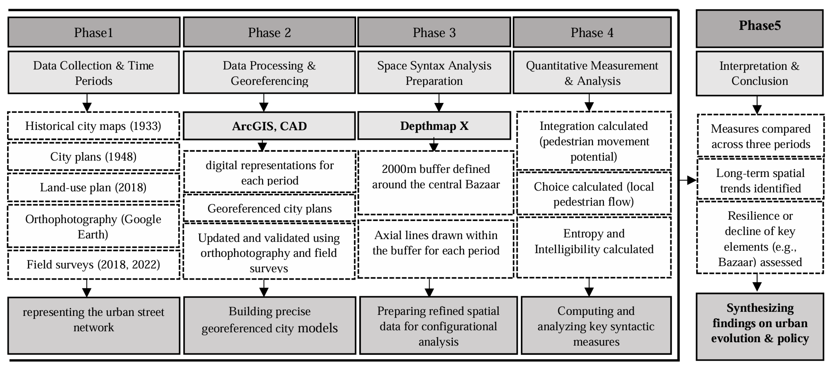
Historical plans were georeferenced using ArcGIS and CAD, updated with orthophotography from Google Earth, and validated through field surveys (2018, 2022). This ensured precise digital representations for each period.
Although the normalized angular measures of Choice (NACH) and Integration (NAIN) were originally introduced within the framework of segment-based angular analysis (Hillier & Iida, 2005; Turner, 2007), the underlying logic of normalization—namely, the adjustment of raw spatial values to account for variations in network size and configuration—can be meaningfully extended to axial analysis. When studying morphological transformation or comparing urban layouts across different temporal or spatial scales, the absence of normalization can produce misleading results, since larger or denser systems naturally exhibit lower mean depth and higher potential for through-movement (B. Hillier, 2015; Hillier & Hanson, 1984,).
When studying morphological transformation or comparing urban layouts across different temporal or spatial scales, the absence of an empirical normalization can produce misleading results, since larger or denser systems naturally exhibit lower mean depth and higher potential for through-movement (Hillier & Hanson, 1984; Hillier, 1996). Furthermore, the standard topological normalization, Real Relative Asymmetry (RRA), was deemed insufficient as it normalizes only against the size (N) of the system, not against its empirically observed relationship between size and depth.
In this research, we adapted the empirical normalization structure established by the segment model for the topological axial integration and choice measures to ensure cross-period comparability. This involved substituting the topological metrics into the established normalization framework. The resulting metrics are defined as:
- Normalized Axial Integration (NAI):
- 2.
- Normalized Axial Choice (NAC):
where:
is the Topological Total Depth of axial line i (the sum of the shortest path steps/turns from i to all other lines).
This adaptation preserves the comparative interpretability of “to-movement” and “through-movement” potentials, while maintaining the representational clarity of the axial map. Such an approach is supported by prior discussions emphasizing the continuity between axial and segment-based syntactic reasoning (Dalton, 2001; W. R. G. Hillier et al., 2012; Turner, 2007). Hence, while the terminology “NACH” and “NAIN” remains specific to angular segment analysis, their normalization logic is here applied to axial measures to facilitate consistent longitudinal and cross-system interpretation of spatial configuration.
The refined datasets were processed in DepthmapX for Space Syntax analysis. To maintain consistency and reduce edge effects, a 2000 m buffer was applied around the central Bazaar, and axial lines were drawn for each historical period.
For each of the three periods (1933, 1948, and 2018), the following key syntactic measures were computed and analyzed to understand walkability dynamics:
- The meaning of ‘Integration’ as well as NAI as a potential for explaining the pedestrian movement (can be read as walking passes) and as the normalized measure of distance from any space of origin, which calculates how close the origin space is to all other spaces which can be read as how the spaces have been used (Foadmarashi & Serdoura, 2021; Hillier & Hanson, 1984; Van Nes & Yamu, 2021).
- The meaning of ‘Choice’ as well as NAC as a syntactic measure, as the potential of local flow of inhabitants, and as a measure of how likely a street segment is to be passed through all routes from all spaces to all other spaces, considering the pedestrian walking distances which can be read as the centrality of the spaces. (Foadmarashi & Serdoura, 2021; Hillier & Hanson, 1984; Van Nes & Yamu, 2021).
- The meaning of entropy as a measure of how spaces are coherently distributed regarding their accessibility to measure the uncertainty of a navigation route (EL-Khouly & Penn, 2012; B. Hillier et al., 1987).
- The meaning of ‘Intelligibility’ as a measure expressing the relationship between local and global integration (R²), reflecting the legibility and perceptual coherence of the urban form. It indicates how easily the overall spatial layout of a city can be understood from its local structure. Higher R² values represent a more legible and cognitively understandable network, whereas lower values indicate spatial fragmentation and difficulty in wayfinding. (Hillier, 1996; Karimi, 2012).
Analyzing these measures across multiple time points captures the dynamic evolution of walkability and the long-term impact of planning interventions, including the resilience or decline of key elements such as the Bazaar. The combination of historical maps, orthophotos, field surveys, and advanced analytical tools enhances accuracy and provides a robust basis for understanding urban change and informing policy recommendations.
4. Case Study Area
The old city of Urmia, covering about 300 hectares, had a cohesive structure before the 1920s, enclosed by a defensive wall with seven main gates (Anzali, 2000; Farnahad, 2023). In the early 20th century, the surrounding moat was transformed into a circular street that now defines the city’s historical boundary and the main study area of this research. Urmia’s urban growth during most of the Islamic period followed a “city–village” model, consisting of several interconnected settlements linked through agricultural exchanges. During the Qajar era, the wall and moat slightly expanded, forming a compact and organic urban fabric centered around the Bazaar and the main routes (Tose va Omran, 1977; Farnahad, 2023). Urmia Bazaar, as one of the earliest parts of the inner city of Urmia, is the oldest passageway connecting the city to nearby neighborhoods and providing services for lo-cals and the entire city. Bazaar is a large area in the city center which includes residential, markets, and covered passes as public spaces, usually considering cultural issues, a va-riety of activities, and land uses (FoadMarashi & Serdoura, 2021).
Urmia Bazaar, as one of the earliest parts of the inner city of Urmia, is the oldest passageway connecting the city to nearby neighborhoods and providing services for lo-cals and the entire city.
Bazaar is a large area in the city center which includes residential, markets, and covered passes as public spaces, usually considering cultural issues, a va-riety of activities, and land uses (FoadMarashi & Serdoura, 2021). Bazaar is the largest and first-born covered public space in the city and is traditionally more coherent with the surrounding direct spaces and neighborhoods. It not only acts as a pass, but it is also the social, cultural, and economic center of the city (Habibi, 2000; Soltanzadeh, 2011).
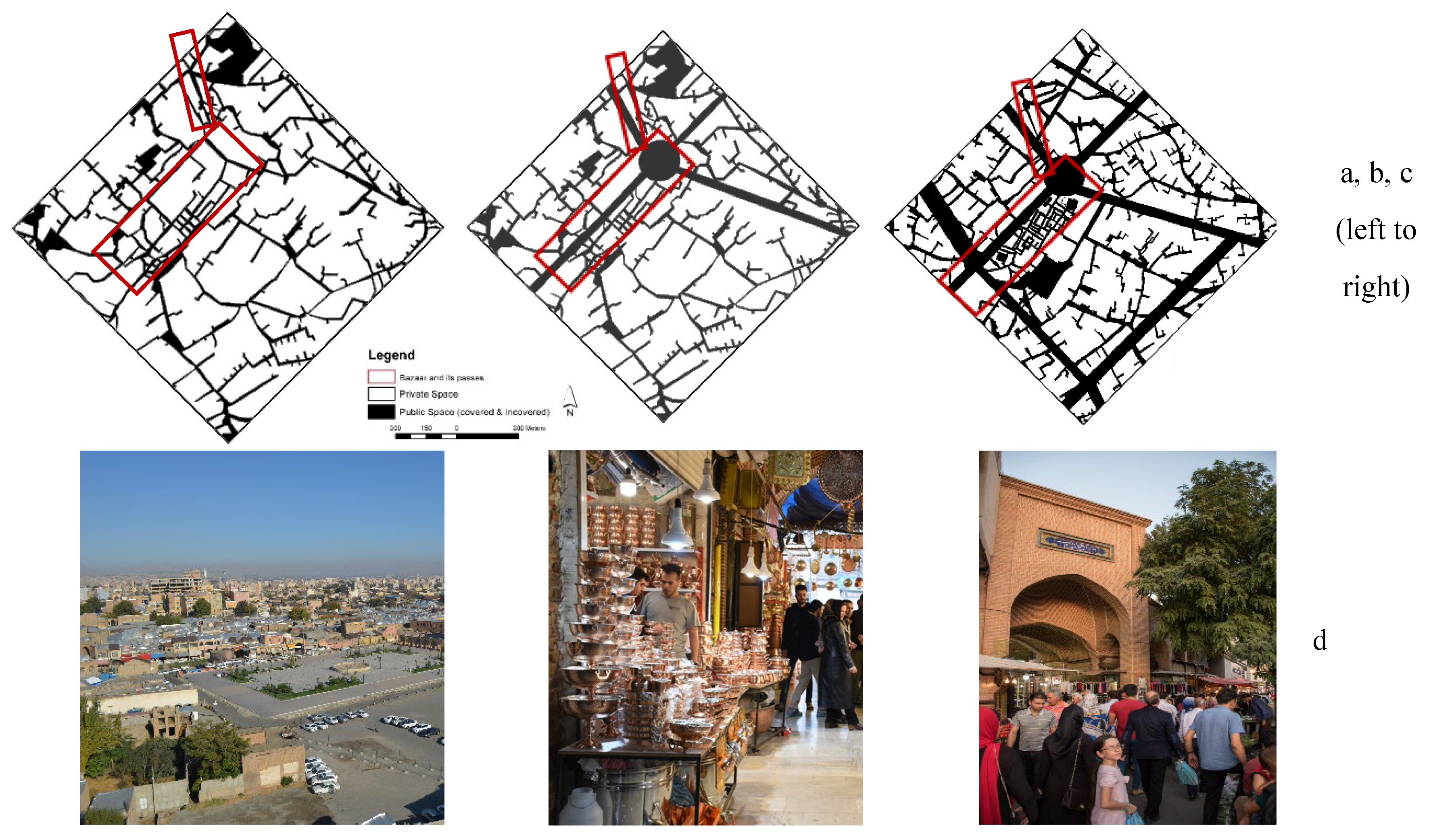
The study area experienced many changes regarding the 20th century’s moderniza-tion and planning. Indeed, the layout of the public spaces, streets, and squares as the main passing spaces of the city changed with the imposed grids to the inner city as well as the Bazaar and its enclosed spaces (Figure 2).
Figure 2.
Location of the Old Fabric and inner city at present(a).
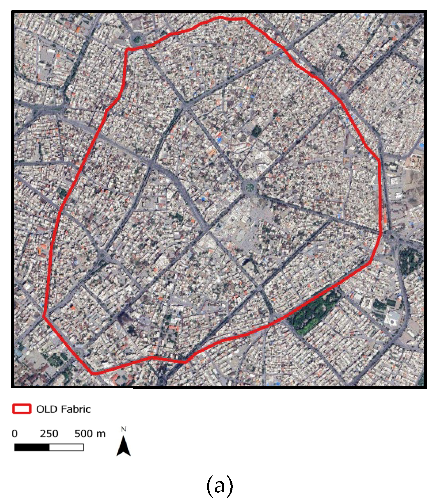
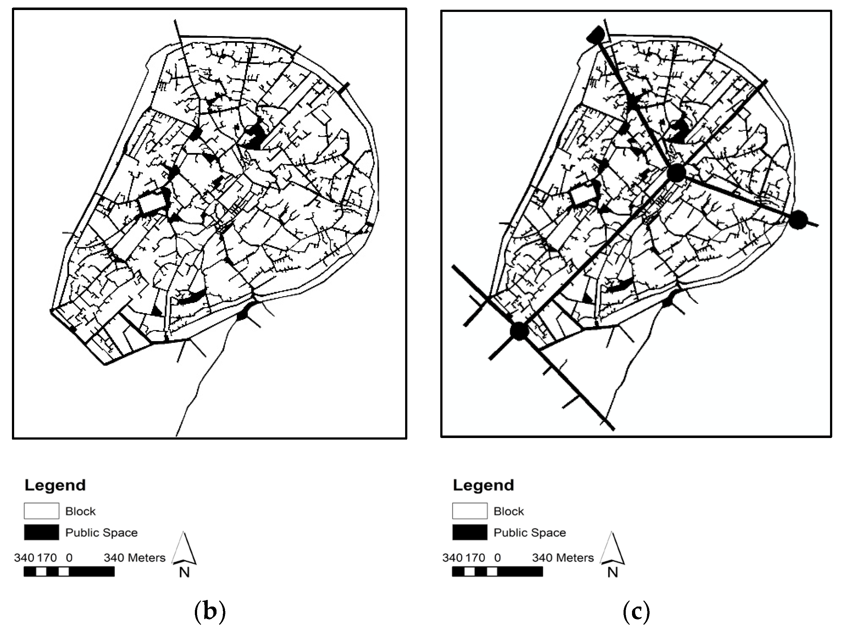
Figure 3.
Urmia city in wall in 1933(b), Urmia city 1948(c)
5. Analysis and Results
5.1. Spatial Configuration of Urmia
Urmia, above all, is a mono-centric city with a very dense fabric in the inner city. Bazaar, as one of the oldest fabrics in the city, describes itself as one of the economically attractive centers and connected spaces to the surroundings. Spatial analysis of the city by using Axial lines as an illustration of the city passes displays that the Bazaar public space is one of the most used spaces through time. Also, axial maps as a linear representation of the fabric addressed the compactness of the city layout, mainly in the center and inner city with small blocks and dead ends (Figure 4).
Figure 4.
Urmia inner city in a modern grid in 2018(d) (Foadmarashi, 2018; Foadmarashi & Serdoura, 2021).
Figure 4.
Urmia inner city in a modern grid in 2018(d) (Foadmarashi, 2018; Foadmarashi & Serdoura, 2021).
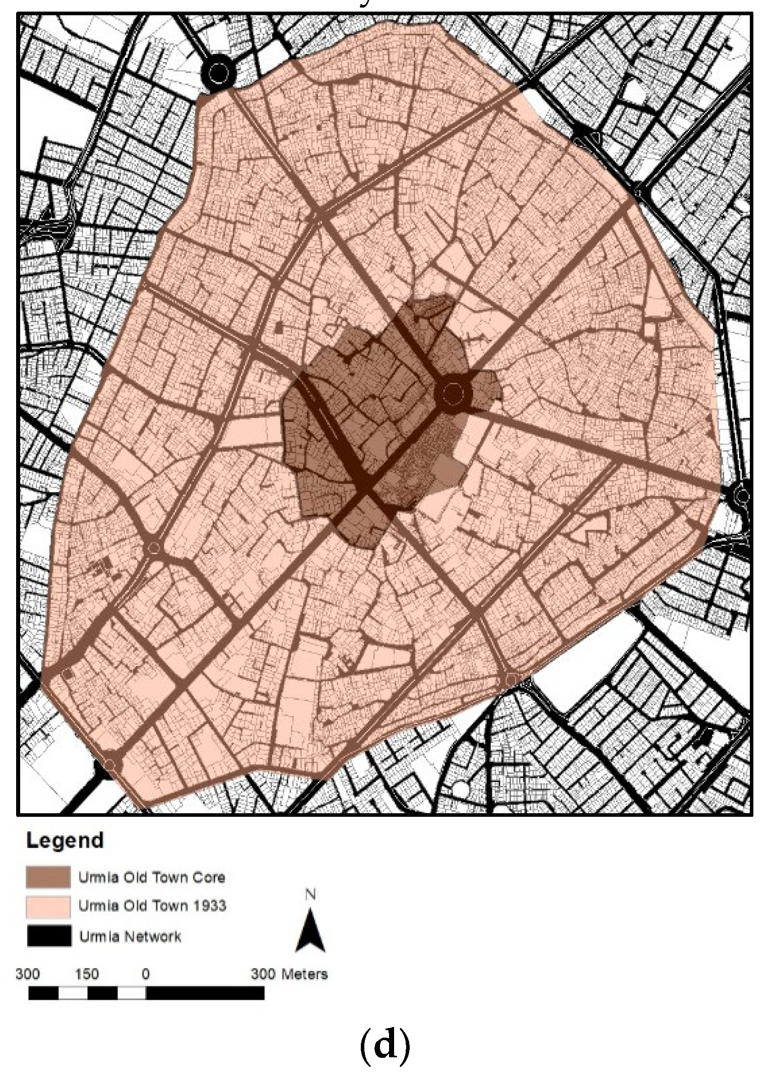
Figure 5.
Changes in the fabric of Urmia Bazaar neighborhood in 1933 (a), 1948 (b) and 2018 (c) and Current views of Urmia Bazaar (d).
Figure 5.
Changes in the fabric of Urmia Bazaar neighborhood in 1933 (a), 1948 (b) and 2018 (c) and Current views of Urmia Bazaar (d).
5.2. Changes in Pedestrian Mobility and Network Expansion
Figure 4 shows how pedestrian mobility happened around the old Urmia Bazaar, before the municipality promoted the new grid to the city and how it acted later through time. It is possible to verify that people tend to make the shortest journeys in their daily commutes, which means taking advantage of the covered Bazaar to move in the center of the city in time. After the new intervention in the urban fabric by designing streets, although the distribution of the walking spaces changes from centric to linear spaces, it still has an important role in the old town (Figure 6, Figure 7, Figure 8 and Figure 9)
Regarding what is announced by global measures of NAC and NAI as the reference of accessibility and the chance of electing the passes by pedestrians, both grew much in time which can be read as an importance of the city center in time. Considering the dramatically increasing values in connectivity of the streets and passes, which is affected by the new imposed grids to the city center, it also attracts attention to the matter that alt-hough the grid system of the city expanded much in recent years (the number of the linear spaces in this study in the inner city increased from 826 to 829 in 1948 and to 1501), which is almost doubled, the NAIN and Choice have increasing values in that area too, which announced the more use of the spaces of the center as well (Figure 3–results were nor-malized between zero and one to better be visualized).
As observed in Table 1 and Figure 6, the “Choice” measure shows the chance that people use streets for their walking travels on all shortest paths from all spaces in their daily walks throughout the system; it confirmed more mobility through the Bazaar block and the inner city by people in their walking ways in time, even in recent years. On the other hand, “Integration” displays how people, when choosing their most direct routes in their regular travels, try to pass through streets where other people also pass, to push socialization activities. It can also be assumed that these walking routes through the inner city are made using the street or covered spaces of Bazaar where the main commercial activities are in the city center (Table 1 and Figure 6 and Figure 7).
5.3. Comparative Findings Across Three Periods
Comparing passes used more by pedestrians in time in the inner city in (Hillier & Hanson, 1984) past and now, it is also found that those spaces which were more used and elected by the pedestrians are in the Bazaar block. Moreover, looking to Figures 6 to 9 and Table 1, it is announced that more spaces have been elected in the inner city and the pe-destrian passes were not limited to the city center.
5.4. Entropy and the Shift in City Structure
While the city grew, public spaces developed and new grids were imposed, the entropy measure to announce the distribution of the spaces decreased in the last 90 years in the inner city from 4.072 to 3.048. Entropy, on one hand, is used to define how city spaces are distributed in the city, and can address how coherent the city structure is; it shows that while the city developed by new imposed grids, the city started to change its mono-centricity to more linear spaces of the new streets. Following this, it can easily be read that the monocentric form of the city changes to a linear-centric structure, which still has the effects of the old construction on the city structure.
Even more focus on how it reacts with the integration, it showed more expansion on the form and less coherence in the spaces, which can address the changing of use of the public spaces as well as walking routes. As seen in Table 1 and Figure 6 and Figure 9, it confirms that more spaces are selected by people in their daily journeys, which can define more social and economic activities in public spaces. This study indicates that connectivity dramatically increased due to new imposed grids and resulted in more accessibility and improved people's mobility, yet simultaneously, the uncertainty of a navigation route decreased (Table 1 and Figure 6).
5.5. Intelligibility and Legibility of Urban Form
The intelligibility coefficient (R² between connectivity and local/global integration) was calculated to assess the legibility of Urmia’s urban structure across different periods. The coefficient values remain relatively low in all three periods, indicating a weak correlation between local and global spatial systems. The R² values slightly decreased over time—from 0.2176 in 1933 to 0.2075 in 1948 and 0.2075 in 2018—showing that, although overall connectivity improved, the city’s spatial legibility did not increase significantly (Figure 10). This pattern suggests that modernization and new grid layouts enhanced physical access and connectivity but did not improve the intuitive understanding or perceptual coherence of the city’s spatial configuration.
The analysis of Urmia Old Town's key findings regarding its walkability and urban transformation can be summarized as follows:
- Monocentric Core & Bazaar's Role: Urmia is fundamentally a monocentric city with a highly dense inner core. The Bazaar, as one of the oldest urban fabrics, functions as a powerful economically attractive center and is exceptionally well-connected to its surroundings. Spatial analysis consistently shows the Bazaar public space as one of the most used spaces throughout the analyzed periods.
- Impact of Modernization: While new streets imposed during modernization changed the distribution of walking spaces from centric to linear, the old town, particularly the Bazaar, still maintains an important role.
- Increased Mobility & Connectivity: Global measures of Angular analysis of Nach and NAIN, which reflect accessibility and the likelihood of pedestrians choosing certain paths, have significantly increased over time. This indicates the growing importance and increased use of the city center's spaces.
- Bazaar's Continuing Importance: Spaces within the Bazaar block were consistently more used and chosen by pedestrians over time.
- Shift in City Structure (Entropy): The entropy measure, which indicates the distribution and coherence of spaces, decreased in the inner city. This suggests a change from a monocentric to a linear-centric structure, though the old construction still influences the city's layout.
- Socialization & Commercial Activities: The "Choice" measure confirms increased mobility through the Bazaar block and inner city, even in recent years. "Integration" suggests that people choose routes through streets where others pass, fostering socialization, and these routes often coincide with the Bazaar's commercial areas.
- Improved Accessibility & Mobility: Despite new urban layouts changing the coherence and connection of the Bazaar to its neighboring spaces, the new streets appear to have improved accessibility and improved people's mobility through public spaces. This also indicates that more spaces are being selected by people in their daily journeys, leading to more social and economic activities in public spaces.
- Bazaar's Dynamic Role: The study concludes that the Bazaar and inner city, as a core space in the former fabric, continues to facilitate significant people mobility through its paths and main routes, leading to greater public presence. The axial map analysis confirms that the Bazaar maintains its dynamic role over time, even as the city transitions from a monocentric to a more linear structure.
6. Discussion
The Urmia study's findings resonate with and diverge from three contemporary Space Syntax studies, highlighting both common urban dynamics and unique contextual outcomes. Following the literature presented before as Hillier et al. (1993), Hillier (1996), Penn et al. (1998), and Donegan et al. (2019), synthetic measure values achieved by the Space Syntax method for different times show that the Bazaar was always one of the more used and attractive spaces of the Urmia central area.
Both the Urmia study and the George Town research (Fan et al., 2024) focus on understanding pedestrian dynamics within historic urban cores (Urmia's Bazaar, George Town's UNESCO World Heritage Site) using Space Syntax. Both studies highlight the continuity of the importance and high utilization of traditional/historic areas despite contemporary urban changes. George Town's findings regarding "concentrated pedestrian flows" and an "over-reliance on a limited number of high-choice road segments" resonate strongly with Urmia's observation that Bazaar spaces were "consistently more used and chosen," suggesting a common pattern of strong centrality and intense pedestrian activity in vibrant historic cores. Furthermore, Urmia's finding that new streets improved overall accessibility aligns with George Town's post-improvement simulations, which demonstrated enhanced connectivity and integration after strategic interventions.
Current Urmia and Varanasi (Stavroulaki, 2022) studies provide empirical evidence for the strong correlation between Space Syntax measures (specifically Integration/NAIN) and actual pedestrian volume or activity. The Varanasi study found Normalized Angular Integration (NAIN) to be highly correlated with pedestrian volume and explicitly noted that highly integrated links are typically located on commercial land-use, attracting higher footfall. This directly supports Urmia's finding that the Bazaar, an "economically attractive center," features paths that are "consistently more used and chosen," and that "Integration" routes often coincide with its commercial areas. Both studies underscore the critical importance of understanding the synergistic relationship between spatial configuration and land-use patterns in shaping pedestrian behavior. This strong, consistent correlation across different urban contexts suggests that the functional purpose and socio-economic vitality of a place are profoundly powerful determinants of pedestrian movement. While Space Syntax measures reveal the potential for movement based on spatial configuration, the actualization of that potential into high pedestrian volumes and sustained use is heavily mediated by the presence of attractions, commercial opportunities, and social functions.
This study’s reliance on Integration and Choice aligns with Stavroulaki's (2022) emphasis on angular centrality measures as effective in explaining pedestrian distribution. The Urmia study's observation that the Bazaar maintains its importance despite increasing overall connectivity (due to new grids) can be interpreted considering Stavroulaki's finding that built density is a better predictor of the absolute volume of pedestrians than centrality alone. This suggests that the functional and economic density of the Bazaar reinforces its spatial centrality, drawing people regardless of minor configurational shifts. Furthermore, Urmia's unique longitudinal approach contributes valuable empirical evidence to Stavroulaki's call for increasing the general predictive power of Space Syntax models, providing insights into long-term spatial dynamics and resilience (Table 1, Figure 6 and Figure 8).
This study’s most significant unique contribution lies in its unprecedented longitudinal analysis spanning nearly a century (1933–2018). This allows for a detailed examination of the evolution of walkability and the resilience of a historic core under distinct and significant urban transformations (from organic growth to the imposition of modern grids). While studies like George Town (Fan et al., 2024) and Varanasi (Stavroulaki, 2022) analyze contemporary conditions or propose interventions, Urmia provides a deep historical perspective that reveals the adaptive capacity of urban form and human behavior over multiple generations. Additionally, the explicit use and analysis of "Entropy" as a measure of spatial coherence, and its observed decrease over time, represents a distinct contribution, offering a deeper understanding of the systemic impact of urban change on the distribution and legibility of accessibility.
This apparent contradiction between increased connectivity and reduced entropy suggests a complex interplay. While the introduction of new grids undeniably improves overall connectivity and mobility (making more spaces accessible and facilitating movement), the observed decrease in entropy suggests a potential loss of the original, organic coherence and intuitive navigability of the monocentric structure. This implies that simply increasing the number of connections does not automatically lead to a more "readable" or intuitively comprehensible city. There might be a point where increased linear connectivity, while efficient for movement, inadvertently fragments the spatial "story" or legibility of the urban fabric. This is a crucial consideration for urban planners, as it warns against prioritizing sheer quantitative gains in connectivity over the qualitative aspects of spatial experience, such as wayfinding, legibility, and the intuitive understanding of the urban layout. It suggests a need for a balanced approach that considers both the efficiency of movement and the experiential quality of the urban environment, particularly in historic contexts where spatial coherence contributes significantly to character and identity.
In practical terms, this decrease in entropy may have altered how pedestrians experience and perceive the inner city. While the new linear grids enable faster, more direct journeys, they also reduce the element of spatial surprise and the organic sense of discovery that once characterized the old Bazaar’s labyrinthine structure. In other words, navigation might have become simpler but also more predictable and less stimulating, potentially diminishing the richness of pedestrian encounters and spatial diversity. This raises a broader philosophical question for urban designers: should walkability be understood purely as efficiency of movement, or as the experiential depth and social vitality embedded in spatial complexity?
Whereas Urmia Bazaar and its block as a consistently covered public space, was one of the important accessible spaces in former times for social meetings and people movements, and one of the pedestrian walking routes in the inner city, it is expected that the current urban layout, as an imposition of modernization changes on the fabric, can affect the accessibility of this central area.
7. Conclusion
This comprehensive Space Syntax analysis of Urmia Old Town provides a unique historical perspective, revealing how its historic core—particularly the Bazaar—has demonstrated remarkable resilience in the face of significant urban transformations. The study illustrates that the city's deep-rooted urban fabric still profoundly influences people's mobility and behavior, challenging the assumption that modernization would lead to the decline of traditional public spaces.
Our research unequivocally confirms that the Urmia Bazaar has not only maintained its role but has often intensified its function as a central pedestrian hub, even as the city's structure shifted from a monocentric to a more linear form. We found that the introduction of new streets and grids, while altering pedestrian flows, ultimately led to increased overall accessibility and mobility in the city center.
The findings underscore that the enduring power of socio-economic anchors, combined with their inherent spatial centrality, are critical determinants of pedestrian activity. While Space Syntax effectively quantifies the potential for movement, the actualization of this potential into high pedestrian volumes is significantly mediated by the presence of commercial, social, and cultural attractions.
Based on these insights, we offer the following key recommendations for urban designers and urban transportation planners, and decision-makers:
- Prioritize Historic Cores: Recognize and enhance historic centers as dynamic, functional pedestrian hubs rather than bypassing them. Planning efforts should focus on improving connectivity to and within these areas.
- Integrate Thoughtfully: Design new urban and transportation networks to complement and funnel movement towards existing vibrant centers, ensuring seamless and continuous pedestrian pathways that link old and new urban fabrics.
- Align Land Use with Spatial Design: Develop strategic land-use policies that co-locate attractions along highly integrated pedestrian routes. This ensures that spatial potential is actualized into vibrant public life and economic activity.
- Utilize Space Syntax for Planning: Employ Space Syntax not just for diagnostic analysis but also as a predictive tool to model the impact of proposed changes on pedestrian flow, accessibility, and spatial character. This enables evidence-based, heritage-sensitive planning.
Practical Implications: The study provides a practical framework for evaluating the long-term impacts of urban design and modernization on pedestrian mobility and spatial coherence. The results suggest that urban regeneration should emphasize the integration of new connectivity networks with the preservation of historical cores to sustain walkability and spatial identity. The analytical approach developed here could serve as a decision-making tool for planners seeking to assess the balance between accessibility and experiential quality in urban design.
Future studies could use real pedestrian movement data and public surveys to test and extend the findings of this research. Applying the same framework to other Iranian or Middle Eastern cities could reveal different patterns of historic urban change. Finally, combining spatial analysis with sustainability and climate indicators could lead to a more complete understanding of walkability and urban transformation.
In conclusion, the Urmia study offers invaluable lessons for urban regeneration globally. It advocates for a thoughtful, adaptive planning approach that respects the deep-seated spatial logic of historic cities, aiming for harmonious integration and sensitive evolution rather than disruptive transformation.
Acknowledgment
To the Portuguese Foundation of Science and Technology (FCT) for the PhD scholarship of the first author, since national funds finance this work through FCT – Fundação para a Ciência e a Tecnologia, I.P., under the PhD scholarship with the reference SFRH/BD/147266/2019.
To Eng. Aida Sedighinanloo and Eng. Edison Khenanisho for their accompany on editing and preparing Shape files for the final paper.
Appendix A

Table A1.
Overview of Key Literature on Space Syntax and Walkability.
| Author(s) & Year | Primary Focus/Contribution | Key Concepts/Findings | Relevance to Walkability & Space Syntax |
|---|---|---|---|
| Theoretical Framework | |||
| Hillier and Hanson (1984), Hillier et al. (1993) | Established Space Syntax as a method for spatial analysis/modeling. | Introduced "natural movement" theory, linking urban form, function, transformation, and pedestrian activity. | Foundational work defining Space Syntax and its application to understanding urban movement patterns. |
| Batty (2013) | Defined urban "big data" and its implications for city management. | Emphasized urban data's spatial and temporal tagging; highlighted its potential for understanding urban dynamics across time. | Connects the availability of "what happens where and when" data in cities to urban management, laying groundwork for data-driven walkability analysis. |
| Gomes (2014); Hillier & Hanson (1984); Hillier & Iida (2005); Madanipour et al. (2014); Penn et al. (1998) | Discussion on public spaces, accessibility, urban dynamics, human behaviors, and interactions. | Clearly accepted strong relation between public spaces, human activities, and how people use them. | Reinforces the importance of public space design and its direct link to human activity and walkability. |
| Gehl (2011); Kostof (1999) | Outdoor activities in medieval cities and urban makeover. | Streets and squares shaped to support residences' activities and passageways; ordered pedestrians. | Historical perspective on urban design's influence on pedestrian movement and public life. |
| Jacob (1961) | Modernist look at urban fabric, variety of activities in streets, block size effects. | Short blocks lead to more accessibility, activities, social interactions, and walking/pedestrian spaces. | Emphasizes block size as a key urban design element impacting walkability and social interaction. |
| Katz (1994) | New Urbanism design guidelines. | Emphasizes pedestrian streets and mixed-use neighborhoods to integrate vitality in cities. | Highlights contemporary urban planning principles that prioritize walkability and mixed uses. |
| Giles-Corti et al. (2016) | Defined walkability as a main factor illustrating pedestrian presence. | Degree to which built environment supports walking, encouraging social and health benefits. Complex concept encompassing physical, social, and cultural factors. | Provides a comprehensive definition of walkability, underscoring its multifaceted nature beyond mere physical infrastructure. |
| Cervero & Kockelman (1997) | Defined walkability regarding public space pedestrian-friendliness. | Includes features like sidewalk continuity, street connectivity, safe crossings, public transit access, and other physical activity encouragement. | Details specific physical features that contribute to walkability, often quantifiable in Space Syntax studies. |
| Van Nes (2014) | Stressed Space Syntax's success. | "Concise definition of space and a high degree of falsifiability and testability." Confirmed Space Syntax's philosophy and methodology for examining social behavior, actions, and spatial configuration. | Explains the underlying strengths and empirical rigor of Space Syntax methodology. |
| Hillier (1996); Hillier et al. (1993); Penn et al. (1998) | Space Syntax philosophy and methodology regarding social behavior and spatial configuration. | Examined the relationship of social behavior, actions, and spatial configuration. | Reaffirms the core premise of Space Syntax: that spatial layout influences social patterns. |
| Carr et al. (2010); Jacobs (1961) | Walkability as a key factor in urban design and planning. | Refers to the extent to which an environment is pedestrian-friendly and supports walking. | Reinforces walkability as a fundamental concept in urban design. |
| Hillier (1996); Turner (2001) | Space Syntax theory on spatial configuration's impact. | Significant impact on walkability, social interaction, economic activity, and environmental sustainability. | Broadens the scope of Space Syntax's influence beyond just movement to include wider urban performance. |
| Lin & Ban (2017); Porta et al. (2006) | Space Syntax analysis for understanding spatial properties affecting walkability. | Density and connectivity of street network, accessibility and visibility of public spaces, proximity and diversity of destinations. | Identifies specific spatial properties analyzed by Space Syntax that directly influence walkability. |
| Lin & Ban (2017); Turner et al. (2001); Ye et al. (2018) | Space Syntax analysis revealing interconnections and informing urban design. | Can reveal how different parts are interconnected, how people move/interact, and help identify barriers to walkability. Informs strategies for pedestrian-friendly environments. | Demonstrates the practical application of Space Syntax in identifying walkability issues and guiding design interventions. |
| Hillier (2009); Hillier & Hanson (1984); Donegan et al. (2019) | Syntactic measures: Permeability (Integration & Choice). | Integration: Potential to movement, accessibility for visitors/pedestrians. Choice: Potential through movement, betweenness, often chosen as shortcut/bypass, related to residents' flow. | Defines the two primary Space Syntax measures (Integration and Choice) and their relevance to different types of pedestrian movement. |
| Review of Recent Studies | |||
| Fan et al. (2024) - George Town, Penang | Improving pedestrian accessibility and safety in a historic city. | Used axial and segment mapping, DepthmapX to analyze connectivity, integration (local, 400m), intelligibility, and choice. Identified poor network connectivity, inadequate access to attractions, suboptimal intelligibility (R²=0.593). Simulations showed improvements. | Empirically applies Space Syntax to a real-world urban planning problem, demonstrating its utility in assessing and improving pedestrian environments in historic contexts. Highlights intelligibility as a key challenge in complex layouts. |
| Nag et al. (2022) - Varanasi, India | Measuring connectivity of pedestrian street networks. | High correlation between Normalized Angular Integration (NAIN) and pedestrian volume (r=0.57, p=0.012). MLR and path models confirmed relationship with NAIN, ROW, sidewalks, and commercial area. Very low intelligibility (0.014). | Provides empirical evidence for the predictive power of Space Syntax (NAIN) on pedestrian volume, especially when combined with built environment features. Emphasizes the critical issue of poor wayfinding in organically developed cities. |
| Stavroulaki (2022) - Directions in Space Syntax | Broader perspective on Space Syntax evolution and future directions for sustainable urban development. | Argues for Space Syntax's capability to model pedestrian flows. Highlights increased predictive power with empirical data (Wi-Fi signals), built density, and accessibility to attractions. Angular centrality explains pedestrian distribution (up to 65%), but built density stronger for absolute volume. Lower angular thresholds (10-20°) correlate strongly with flows. | Offers a meta-analysis of Space Syntax's predictive capabilities, emphasizing the importance of combining configurational measures with land use and density data for more robust models. Points to the challenge of optimizing street network representation. |
| Synthesis of Literature and Key Observations | |||
| (Consistent across studies) | Application and empirical validation of Space Syntax measures. | Integration and Choice consistently effective measures for quantifying pedestrian potential and flow. | Confirms the robustness and wide acceptance of Integration and Choice as core Space Syntax metrics in walkability research. |
| (Varanasi & Stavroulaki) | Relationship between Space Syntax, pedestrian volume, and built environment features. | While spatial layout is foundational, actual pedestrian volume and quality are significantly influenced by physical infrastructure (sidewalks, ROW) and land-use (commercial areas). | Advocates for a holistic approach to urban planning for walkability, integrating configurational design with practical infrastructure and strategic land-use planning. |
| (George Town & Varanasi) | Consistently suboptimal intelligibility scores in historic, organically developed cities. | Implies that complex, irregular layouts can be difficult to navigate for unfamiliar users, even if highly integrated or chosen for movement. | Identifies intelligibility as a crucial, often overlooked, aspect of walkability in historic urban environments, suggesting a need for interventions that enhance spatial legibility. |
References
- Anzali, H. (2000). Urmia in Time (one). Anzali.
- Aparicio, J.T.; Arsenio, E.; Santos, F.C.; Henriques, R. Walkability defined neighborhoods for sustainable cities. Cities 2024, 149, 104944. [Google Scholar] [CrossRef]
- Baobeid, A.; Koç, M.; Al-Ghamdi, S.G. Walkability and Its Relationships with Health, Sustainability, and Livability: Elements of Physical Environment and Evaluation Frameworks. Frontiers in Built Environment 2021, 7. [Google Scholar] [CrossRef]
- Carr, L.J.; Dunsiger, S.I.; Marcus, B.H. Walk ScoreTM As a Global Estimate of Neighborhood Walkability. American Journal of Preventive Medicine 2010, 39(5), 460–463. [Google Scholar] [CrossRef]
- Cervero, R.; Kockelman, K. Travel demand and the 3Ds: Density, diversity, and design. Transportation Research Part D: Transport and Environment 1997, 2(3), 199–219. [Google Scholar] [CrossRef]
- Dalton, N. Fractional Configurational Analysis And a solution to the Manhattan problem. In Proceedings of the 3rd International Space Syntax Symposium.Georgia Institute of Technology; 2001; pp. 26.1–26.13. [Google Scholar]
- Donegan, L.; da Silveira, J.A.R.; da Silva, G.J.A.; Donegan, L.; da Silveira, J.A.R.; Silva, G.J.A.d. Under and over: Location, uses and discontinuities in a centrally located neighbourhood in João Pessoa city reflecting current urban planning effects. Urbe. Revista Brasileira de Gestão Urbana 2019, 11. [Google Scholar] [CrossRef]
- EL-Khouly, T.; Penn, A. (PDF) ORDER, STRUCTURE AND DISORDER IN SPACE SYNTAX AND LINKOGRAPHY: Intelligibility, entropy, and complexity measures. Eighth International Space Syntax Symposium; 2012; pp. 8242:1–8242:22. [Google Scholar]
- Ewing, R.; Cervero, R. Travel and the Built Environment: A Meta-Analysis. Journal of the American Planning Association 2010, 76(3), 265–294. [Google Scholar] [CrossRef]
- Farnahad Consultanat Engineers. Revision of The Urmia Master Plan; 2023. [Google Scholar]
- FoadMarashi, M.; Serdoura, F. Public Space Use: An Approach to Livability in Urmia Bazaar, Iran. In Formal Methods in Architecture; Eloy, S., Leite Viana, D., Morais, F., Vieira Vaz, J., Eds.; Springer International Publishing, 2021; pp. 231–240. [Google Scholar] [CrossRef]
- Frank, L.D.; Sallis, J.F.; Saelens, B.E.; Leary, L.; Cain, K.; Conway, T.L.; Hess, P.M. The development of a walkability index: Application to the Neighborhood Quality of Life Study. British Journal of Sports Medicine 2010, 44(13), 924–933. [Google Scholar] [CrossRef]
- Gehl, J.; Svarre, B. How to Study Public Life; Island Press, 2013. [Google Scholar]
- Giles-Corti, B.; Vernez-Moudon, A.; Reis, R.; Turrell, G.; Dannenberg, A.L.; Badland, H.; Foster, S.; Lowe, M.; Sallis, J.F.; Stevenson, M.; et al. City planning and population health: A global challenge. The Lancet 2016, 388(10062), 2912–2924. [Google Scholar] [CrossRef]
- Gomes, P. Public Space and the Challenges of Urban Transformation in Europe, edited by Ali Madanipour, Sabine Knierbein and Aglaée Degros, New York and London, Routledge, 2014, xi + 217 pp., £27.99 (paperback), ISBN 978-0-415-64055-8. Urban Research & Practice 2014, 7(2), 241–242. [Google Scholar] [CrossRef]
- Gorzka, J.; Burda, I.; Nyka, L. Walkability and Flood Resilience: Public Space Design in Climate-Sensitive Urban Environments. Urban Planning 2025, 10. Available online: https://www.cogitatiopress.com/urbanplanning/article/view/9561. [CrossRef]
- Habibi, S.M. De la Cite de la Ville; A Historical Analysis of The Concept of The City and Its Physical Appearance, 1st ed.; University of Tehran Press, 2000. [Google Scholar]
- Hillier, B. Cities as movement economies. Urban Design International 1996, 1(1), Article 1. [Google Scholar] [CrossRef]
- Hillier, B. Spatial sustainability in cities: Organic patterns and sustainable forms [Proceedings paper]. In Proceedings of the 7th International Space Syntax Symposium. (Pp. p. 1); Koch, D., Marcus, L., Steen, J., Eds.; Royal Institute of Technology (KTH): Stockholm, Sweden; Royal Institute of Technology (KTH), 2009; Available online: http://www.sss7.org/Proceedings_list.html.
- Hillier, B. Space is the machine: A configurational theory of architecture; CreateSpace Independent Publishing Platform, 2015. [Google Scholar]
- Hillier, B.; Hanson, J. The Social Logic of Space; Cambridge University Press, 1984. [Google Scholar] [CrossRef]
- Hillier, B.; Hanson, J.; Graham, H. Ideas are in Things: An Application of the Space Syntax Method to Discovering House Genotypes—B Hillier, J Hanson, H Graham, 1987. Environment and Planning B: Planning and Design 1987, 14(4), 363–385. [Google Scholar] [CrossRef]
- Hillier, B.; Iida, S. Network and Psychological Effects in Urban Movement. In Spatial Information Theory; Cohn, A.G., Mark, D.M., Eds.; Springer, 2005; pp. 475–490. [Google Scholar] [CrossRef]
- Hillier, B.; Penn, A.; Hanson, J.; Grajewski, T.; Xu, J. Natural Movement: Or, Configuration and Attraction in Urban Pedestrian Movement. Environment and Planning B: Planning and Design 1993, 20(1), 29–66. [Google Scholar] [CrossRef]
- Hillier, W.R.G.; Yang, T.; Turner, A. Normalising least angle choice in Depthmap—And how it opens up new perspectives on the global and local analysis of city space. Journal of Space Syntax 2012, 3, 155–193. [Google Scholar]
- Jabbari, M.; Fonseca, F.; Ramos, R. Combining multi-criteria and space syntax analysis to assess a pedestrian network: The case of Oporto. Journal of Urban Design 2018, 23(1), 23–41. [Google Scholar] [CrossRef]
- Karimi, K. A configurational approach to analytical urban design: ‘Space syntax’ methodology. URBAN DESIGN International 2012, 17(4), 297–318. [Google Scholar] [CrossRef]
- Lin, J.; Ban, Y. Comparative Analysis on Topological Structures of Urban Street Networks. ISPRS International Journal of Geo-Information 2017, 6(10), Article 10. [Google Scholar] [CrossRef]
- Ma, P.; Rebecchi, A.; Manfredini, F.; Ahlert, M.; Buffoli, M. Promoting Public Health Through Urban Walkability: A GIS-Based Assessment Approach, Experienced in Milan. Sustainability 2025, 17(7), 2939. [Google Scholar] [CrossRef]
- Madanipour, A.; Knierbein, S.; Degros, A. Public space and the challenges of urban transformation in Europe. Public Space and the Challenges of Urban Transformation in Europe. 2014. Available online: https://eprints.ncl.ac.uk.
- Maniei, H.; Askarizad, R.; Pourzakarya, M.; Gruehn, D. The Influence of Urban Design Performance on Walkability in Cultural Heritage Sites of Isfahan, Iran. Land 2024, 13(9), 1523. [Google Scholar] [CrossRef]
- Mark, L.; Holec, K.; Escher, T. Socio-spatial justice through public participation? A mixed-methods analysis of distributive justice in a consultative transport planning process in Germany. Case Studies on Transport Policy 2025, 20, 101467. [Google Scholar] [CrossRef]
- van Nes, A. Indicating street vitality in excavated towns. Spatial configurative analyses applied to Pompeii. In Spatial analysis and social spaces; De Gruyter, 2014; pp. 277–296. Available online: https://www.degruyter.com/view/book/9783110266436/10.1515/9783110266436.277.xml.
- Pafka, E.; Biraghi, C.A. Walkability: From Spatial Analytics to Urban Coding and Actual Walking. Urban Planning 2025, 10. [Google Scholar] [CrossRef]
- Penn, A.; Hillier, B.; Banister, D.; Xu, J. Configurational Modelling of Urban Movement Networks. Environment and Planning B: Planning and Design 1998, 25(1), 59–84. [Google Scholar] [CrossRef]
- Porta, S.; Crucitti, P.; Latora, V. The Network Analysis of Urban Streets: A Primal Approach. Environment and Planning B: Planning and Design 2006, 33(5), 705–725. [Google Scholar] [CrossRef]
- Ramos, C.D.G.; Mourato, J.; Sousa Vale, D. Uncovering walkability: A chronological literature review. Transport Reviews 2025, 1–22. [Google Scholar] [CrossRef]
- Sharifi, A.; Yamagata, Y. Resilient Urban Planning: Major Principles and Criteria. Energy Procedia 2014, 61, 1491–1495. [Google Scholar] [CrossRef]
- Soltanzadeh, H. A Brief History of the City and Urbanization in Iran (ancient Era to1976), 1st ed.; Chahar Tagh, 2011. [Google Scholar]
- Stutz, P.; Kaziyeva, D.; Traun, C.; Werner, C.; Loidl, M. Walkability at Street Level: An Indicator-Based Assessment Model. Sustainability 2025, 17(8), 3634. [Google Scholar] [CrossRef]
- Tose va Omran Consultant Engineers. Detailed Plan of the Urmia City; 1977. [Google Scholar]
- Turner, A. Depthmap: A program to perform visibility graph analysis. Paper presented at The Third International Space Syntax Symposium, Georgia Technological Institute; 2001. [Google Scholar]
- Turner, A. From Axial to Road-Centre Lines: A New Representation for Space Syntax and a New Model of Route Choice for Transport Network Analysis. Environment and Planning B: Planning and Design 2007, 34(3), 539–555. [Google Scholar] [CrossRef]
- Turner, A.; Doxa, M.; O’Sullivan, D.; Penn, A. From Isovists to Visibility Graphs: A Methodology for the Analysis of Architectural Space. Environment and Planning B: Planning and Design 2001, 28(1), 103–121. [Google Scholar] [CrossRef]
- Van Nes, A.; Yamu, C. Introduction to Space Syntax in Urban Studies; Springer International Publishing, 2021. [Google Scholar] [CrossRef]
- Vaughan, L.; Peponis, J.; Dalton, R.C. Space Syntax: Selected papers by Bill Hillier; Vaughan, L., Peponis, J., Dalton, R.C., Eds.; UCL Press: London, UK; UCL Press, 2025; pp. 1–679. [Google Scholar] [CrossRef]
- Westenhöfer, J.; Nouri, E.; Reschke, M.L.; Seebach, F.; Buchcik, J. Walkability and urban built environments—A systematic review of health impact assessments (HIA). BMC Public Health 2023, 23(1), 1–19. [Google Scholar] [CrossRef]
- Ye, Y.; Li, D.; Liu, X. How block density and typology affect urban vitality: An exploratory analysis in Shenzhen, China. Urban Geography 2018, 39(4), 631–652. [Google Scholar] [CrossRef]
- Zamanifard, H.; Alizadeh, T.; Bosman, C.; Coiacetto, E. Measuring experiential qualities of urban public spaces: Users’ perspective. Journal of Urban Design 2019, 24(3), 340–364. [Google Scholar] [CrossRef]
- Zhang, J.; Tan, P.Y.; Zeng, H.; Zhang, Y. Walkability Assessment in a Rapidly Urbanizing City and Its Relationship with Residential Estate Value. Sustainability 2019, 11(8), 2205. [Google Scholar] [CrossRef]
Figure 6.
Radar Graph Global measures in Inner city versus the Bazaar block in the linear representation of Urmia Bazaar Block in three periods.
Figure 6.
Radar Graph Global measures in Inner city versus the Bazaar block in the linear representation of Urmia Bazaar Block in three periods.
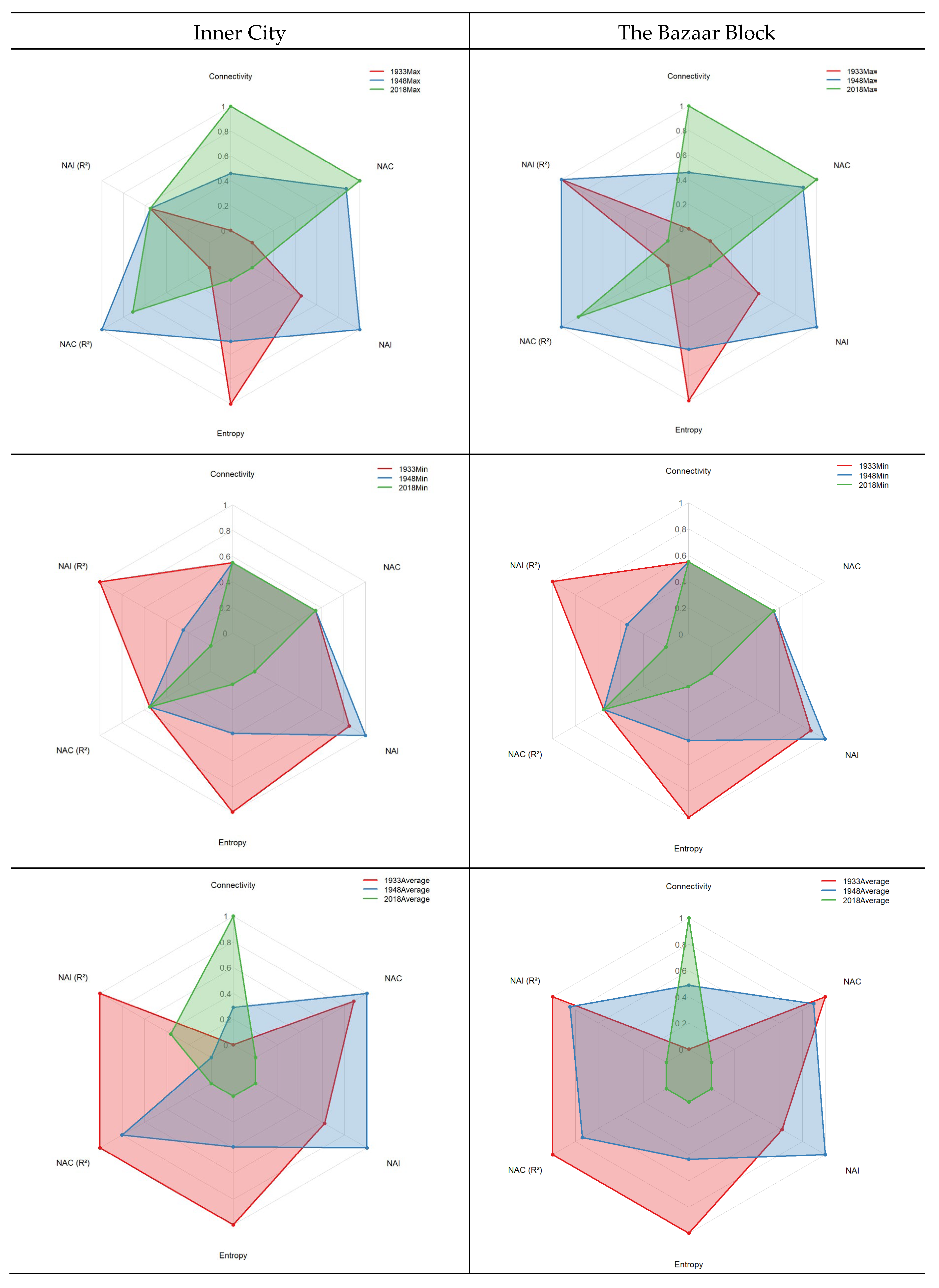
Figure 7.
Comparison of the NAI measures in three different periods in Urmia inner city and Bazaar block.
Figure 7.
Comparison of the NAI measures in three different periods in Urmia inner city and Bazaar block.
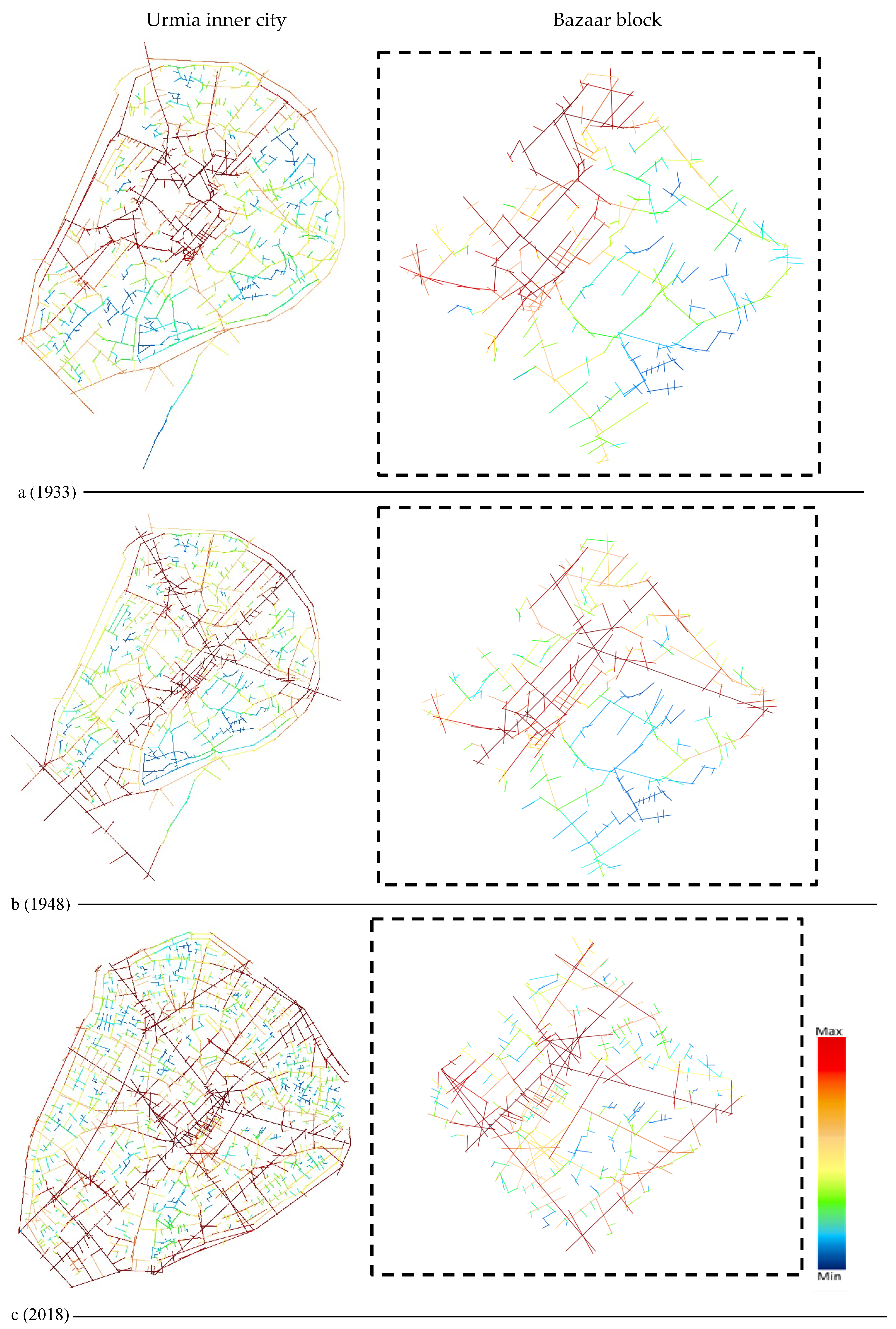
Figure 8.
Comparison of the NAC measure in three different periods Urmia inner city and Bazaar block.
Figure 8.
Comparison of the NAC measure in three different periods Urmia inner city and Bazaar block.

Figure 9.
Comparison of the changes in Entropy in the fabric of Urmia inner city in three periods.
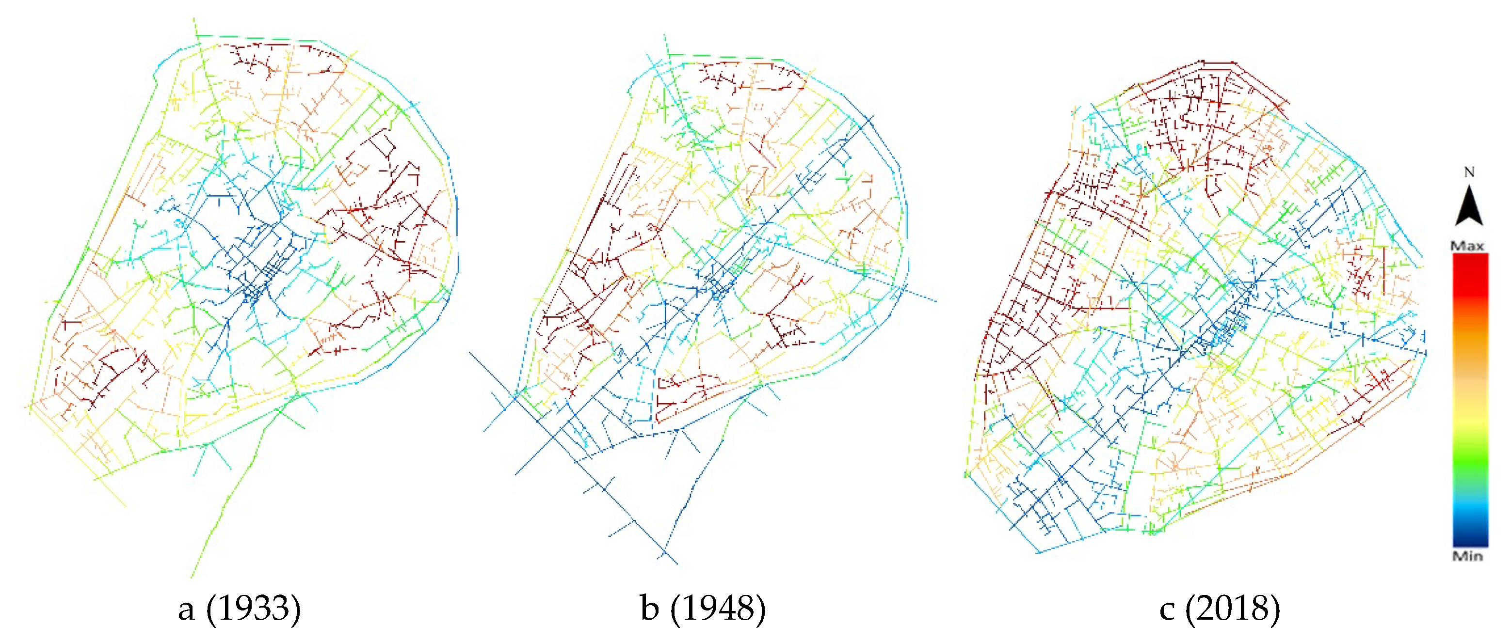
Figure 10.
Intelligibility coefficients (R² between connectivity and local/global integration) for the inner city of Urmia in 1933, 1948, and 2018.
Figure 10.
Intelligibility coefficients (R² between connectivity and local/global integration) for the inner city of Urmia in 1933, 1948, and 2018.
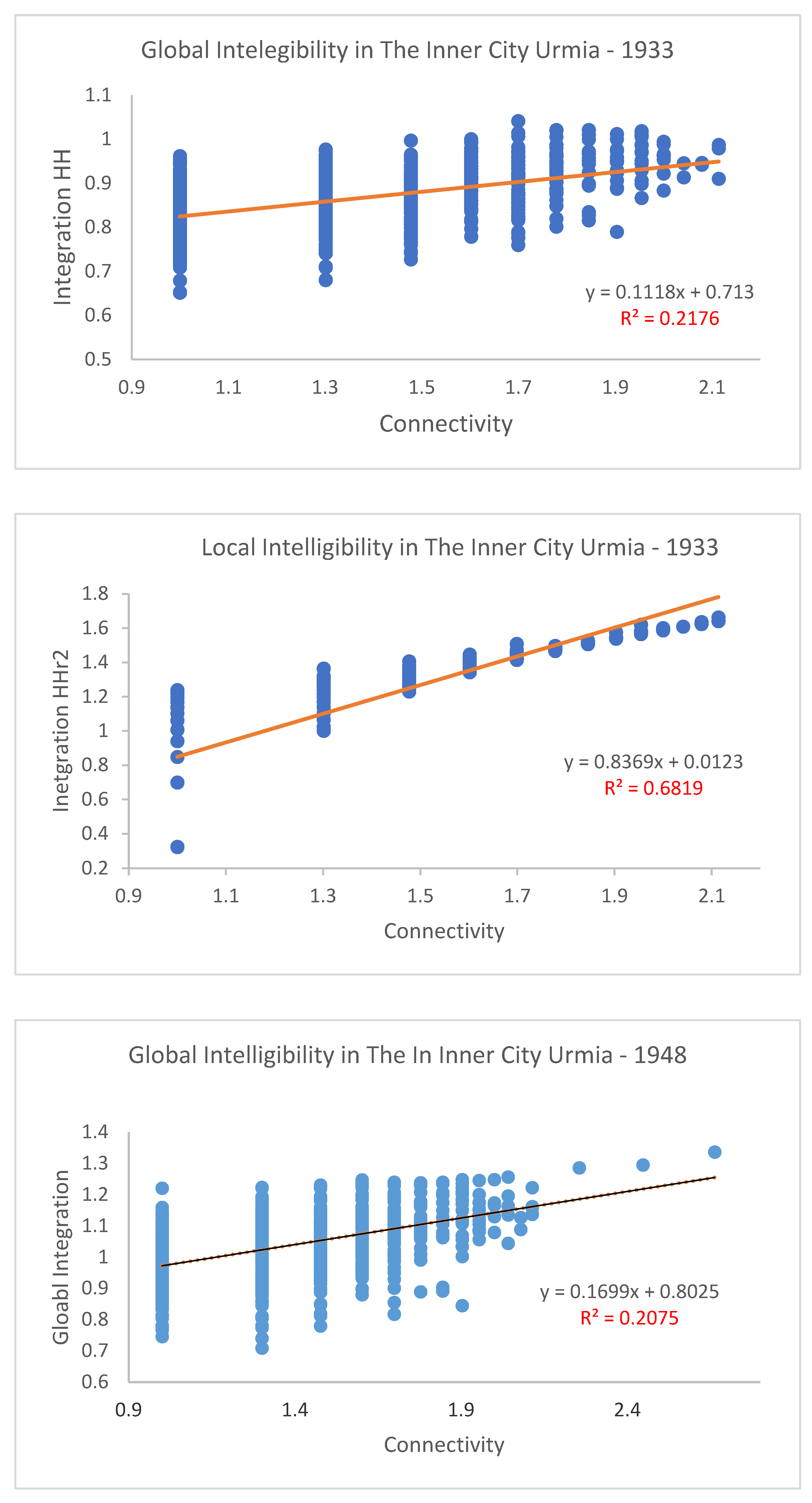
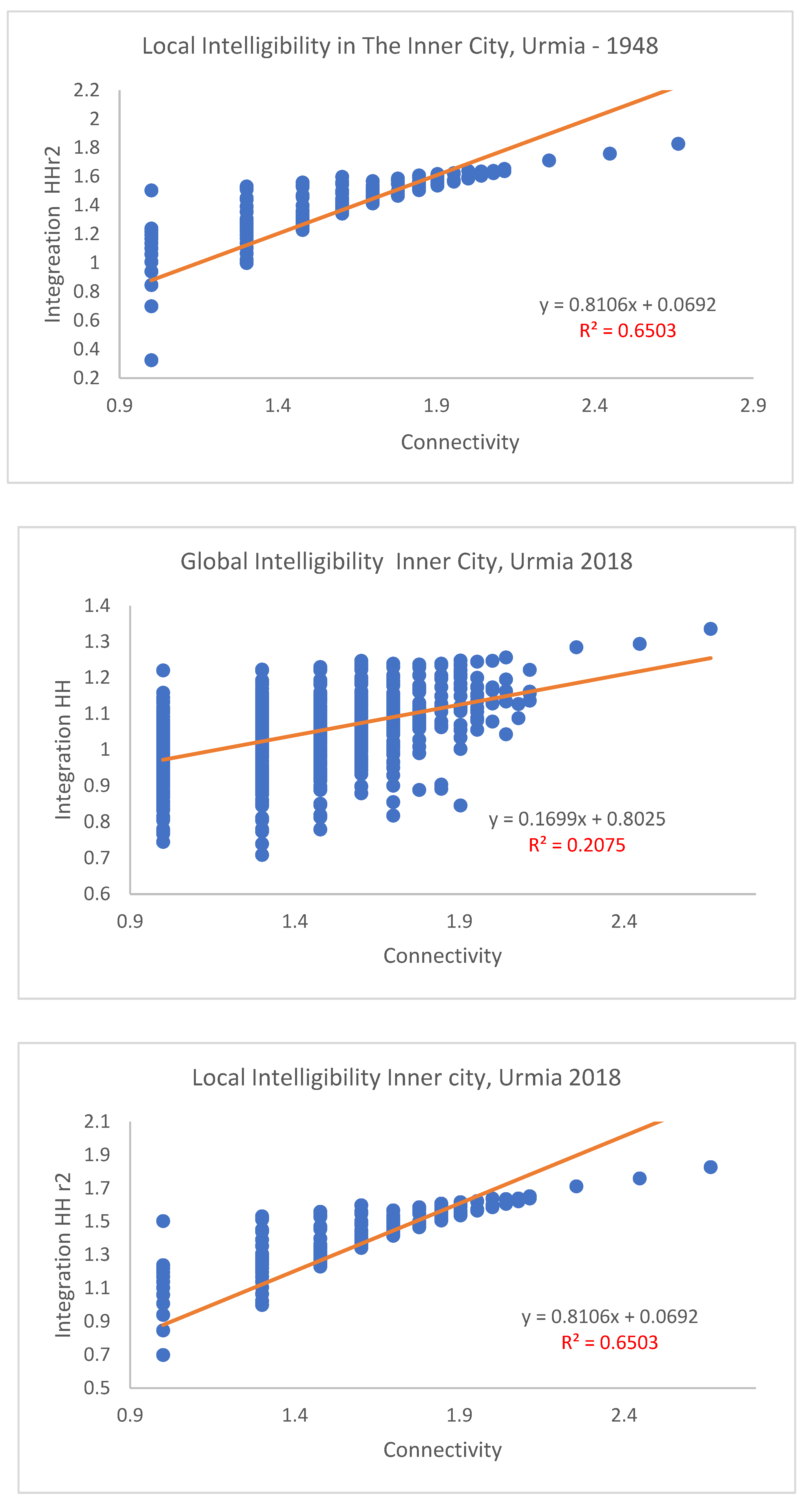
Table 1.
Global measures, including NAC and NAI, in the linear representation of the Urmia inner city versus Bazaar block in three periods.
Table 1.
Global measures, including NAC and NAI, in the linear representation of the Urmia inner city versus Bazaar block in three periods.
| year | level | Case study Urmia Bazaar Block | ||||||
|---|---|---|---|---|---|---|---|---|
| NAC | NAC r2 | Connectivity | Entropy | NAI | NAI r2 | |||
| 1933 | Max | 1.341439 | 1.244948 | 13 | 4.05235 | 0.000615 | 0.259384 | |
| Min | 0 | 0 | 1 | 3.443708 | 0.00034 | 0.024715 | ||
| Average | 0.708044 | 0.472593 | 3.623188406 | 3.760397 | 0.000473 | 0.086219 | ||
| 1948 | Max | 1.583007 | 1.349069 | 46 | 3.551014 | 0.001002 | 0.259384 | |
| Min | 0 | 0 | 1 | 2.938095 | 0.000371 | 0.008861 | ||
| Average | 0.702157 | 0.458066 | 4.087452471 | 3.165736 | 0.000644 | 0.078621 | ||
| 2023 | Max | 1.618063 | 1.332413 | 85 | 2.853 | 0.000292 | 0.15904 | |
| Min | 0 | 0 | 1 | 2.5829 | 0.000125 | 0.000625 | ||
| Average | 0.651307 | 0.416924 | 4.575596817 | 2.707674 | 0.000194 | 0.036586 | ||
| Inner City of Urmia | ||||||||
| NAC | NAC r2 | Connectivity | Entropy | NAI | NAI r2 | |||
| 1933 | Max | 1.341439 | 1.290537 | 13 | 4.071741 | 0.000615 | 0.259384 | |
| Min | 0 | 0 | 1 | 3.443708 | 0.000298 | 0.024468 | ||
| Average | 0.614342 | 0.413012 | 3.044740024 | 3.840315 | 0.000453 | 0.100452 | ||
| 1948 | Max | 1.583007 | 1.349069 | 46 | 3.554616 | 0.001002 | 0.259384 | |
| Min | 0 | 0 | 1 | 2.911469 | 0.000331 | 0.008861 | ||
| Average | 0.620543 | 0.403187 | 3.189156627 | 3.185177 | 0.00062 | 0.095075 | ||
| 2023 | Max | 1.618063 | 1.332413 | 85 | 3.048458 | 0.000292 | 0.259384 | |
| Min | 0 | 0 | 1 | 2.5829 | 0.000105 | 0.00378 | ||
| Average | 0.568486 | 0.363084 | 3.542609854 | 2.761937 | 0.000181 | 0.097031 | ||
Disclaimer/Publisher’s Note: The statements, opinions and data contained in all publications are solely those of the individual author(s) and contributor(s) and not of MDPI and/or the editor(s). MDPI and/or the editor(s) disclaim responsibility for any injury to people or property resulting from any ideas, methods, instructions or products referred to in the content. |
© 2025 by the authors. Licensee MDPI, Basel, Switzerland. This article is an open access article distributed under the terms and conditions of the Creative Commons Attribution (CC BY) license (https://creativecommons.org/licenses/by/4.0/).
Copyright: This open access article is published under a Creative Commons CC BY 4.0 license, which permit the free download, distribution, and reuse, provided that the author and preprint are cited in any reuse.


