1. Introduction
A large number of scientific ideas have been discussed during the last decades, presenting tectonic and geodynamic models which tried to geologically explain the causes of the Vrancea intermediate-depth high magnitude earthquakes.
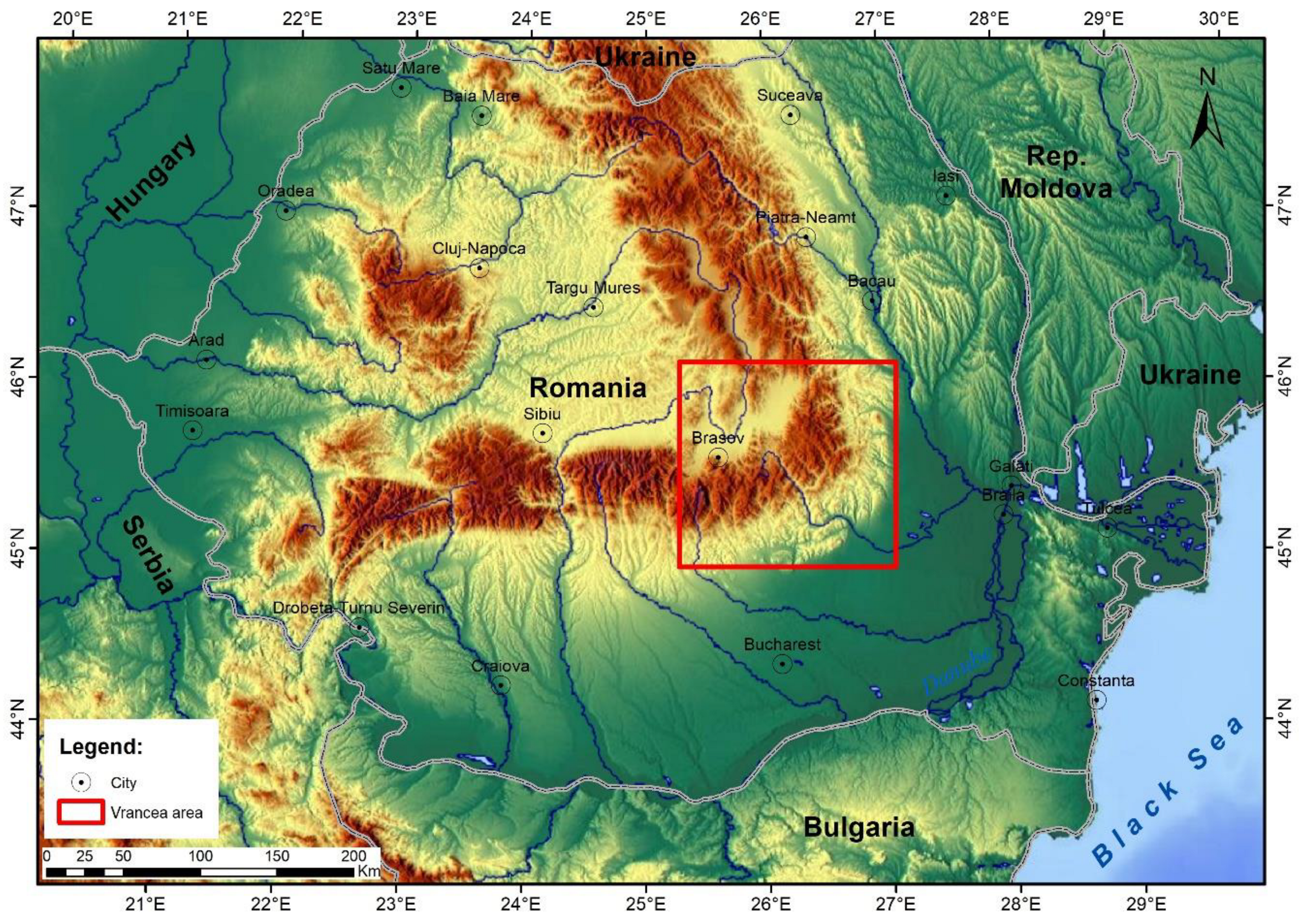
Vrancea is a well known seismogenic structure situated beneath the East Carpathians Bend Zone (
Figure 1).
A recent study has been carried out, the deeply located tectonic structures being investigated using Gravity and Gravimetric Geoid, Terrestrial and Airborne Magnetics, Refraction Seismic, Seismicity, Seismic Tomography and Heat Flow [
2]. The main topics discussed by our research team during the last few years and considered now as significant for understanding the causes of deeply located high magnitude earthquakes, are the following:
- a)
Wrench tectonics system crossing NE-SW Romania [
2,
3];
- b)
Romanian Trough, interpreted at the East Carpathians Bend Zone as the prolongation of the Polish Trough beneath the East Carpathians [
4];
- c)
Past volcanic and intrusive processes in the Vrancea area [
2];
- d)
Geophysical and tectonic model in the Vrancea seismic zone [
2].
Seismicity, regional geodynamics and local tectonics of the Vrancea seismic zone will be briefly presented in this paper, benefiting of the mentioned studies. The seismological database has been here enlarged from the time interval 2014-2020 to 2014-2024.
2. Seismicity of the Vrancea area
The Vrancea zone high seismicity is interpreted in this paper to be determined at crustal depths by active normal faults located within the graben geological structure illustrated by refraction seismic data [
5]. Besides this active tectonic structure, normal faulting is favored by the extensional regime conditioned by a SE regional drag [
3]. This regional geodynamic drag may be at least associated to the dextral displacements along the North Anatolian Fault.
The intermediate-depth high magnitude seismicity is here interpreted to be related to strike-slip movements of the wrench tectonics southern transcurrent fault at lithospheric depths [
2,
6], in a transtensional regime, at the junction with a NW-SE trending strike-slip regional fault system.
There are numerous studies analyzing and aiming at understanding the deep geological structures and tectonic processes as causes of the crustal and subcrustal seismicity in the Vrancea zone (e.g., [
2,
3,
5,
7,
8]). Most studies have been dedicated to the subcrustal seismicity, since it is in direct connection with high magnitude earthquakes that are causing numerous casualties and infrastructure damages, at regional and continental scales. The main registered or evaluated high magnitude earthquakes with magnitude over 7 are the following: 1738 (Mw 7.7), 1802 (Mw 7.9), 1838 (Mw 7.5), 1901 (Mw 7.2), 1908 (Mw 7.1), 1940 (Mw 7.7), 1977 (Mw 7.4), 1986 (Mw 7.1) [
9].
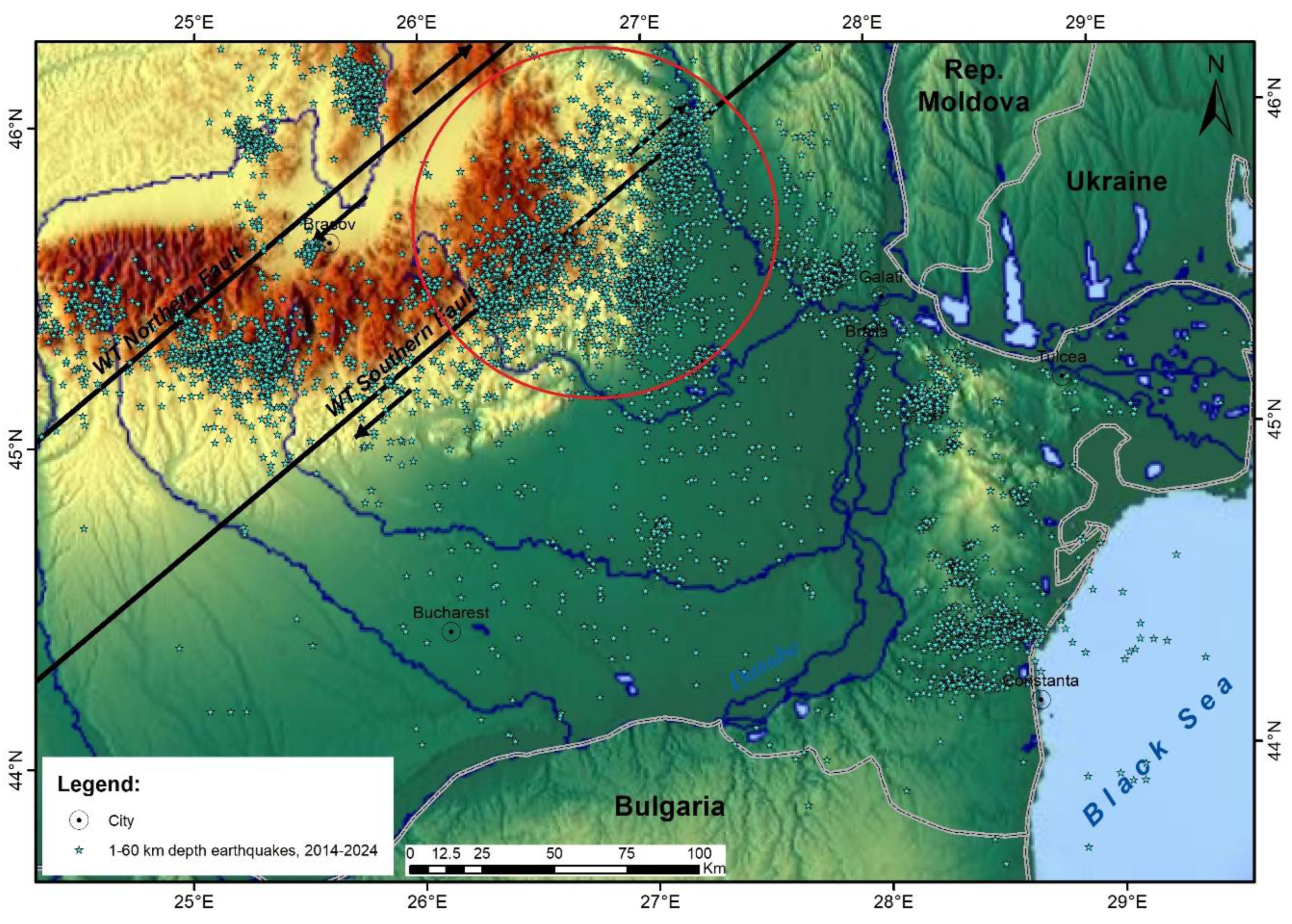
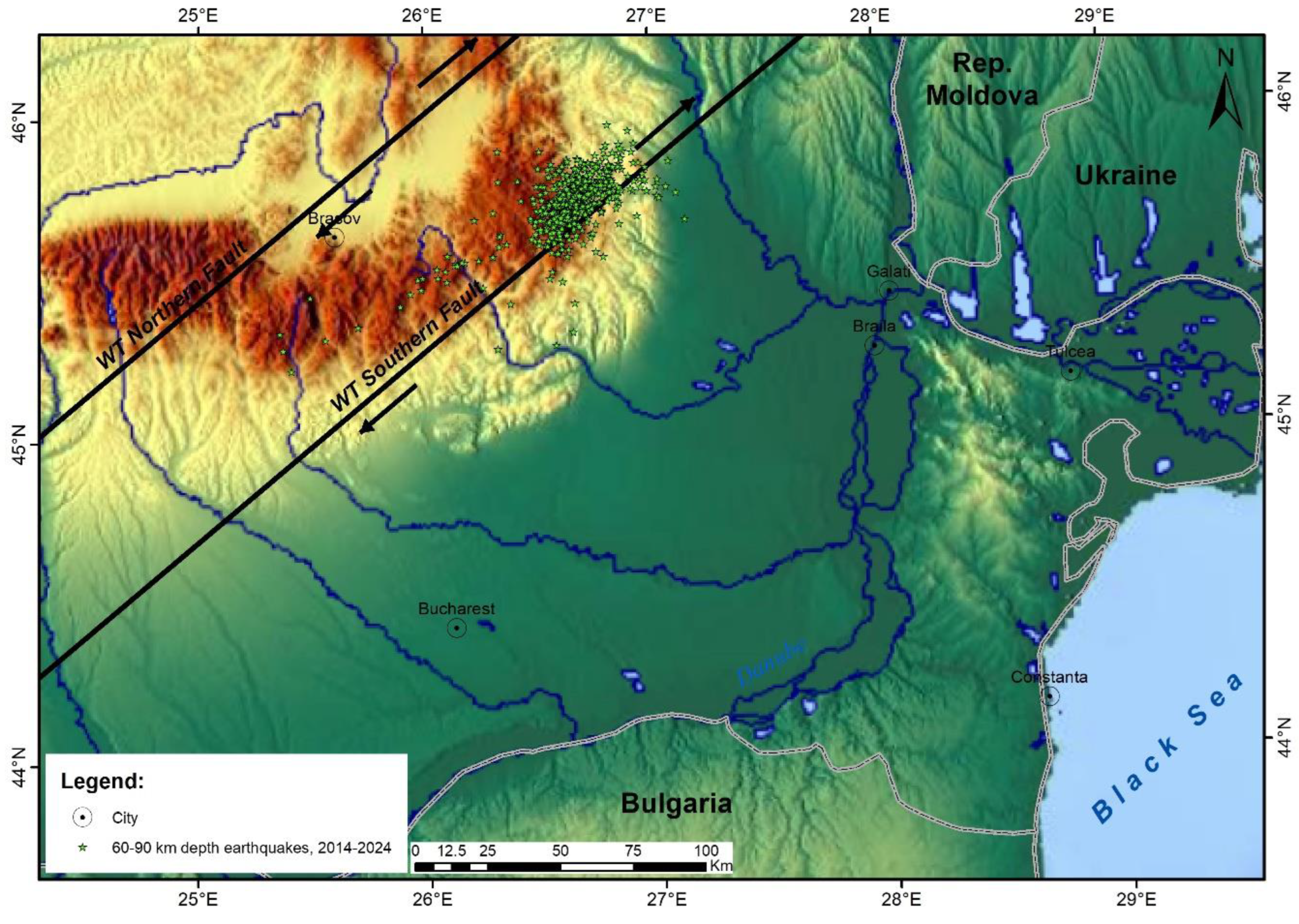
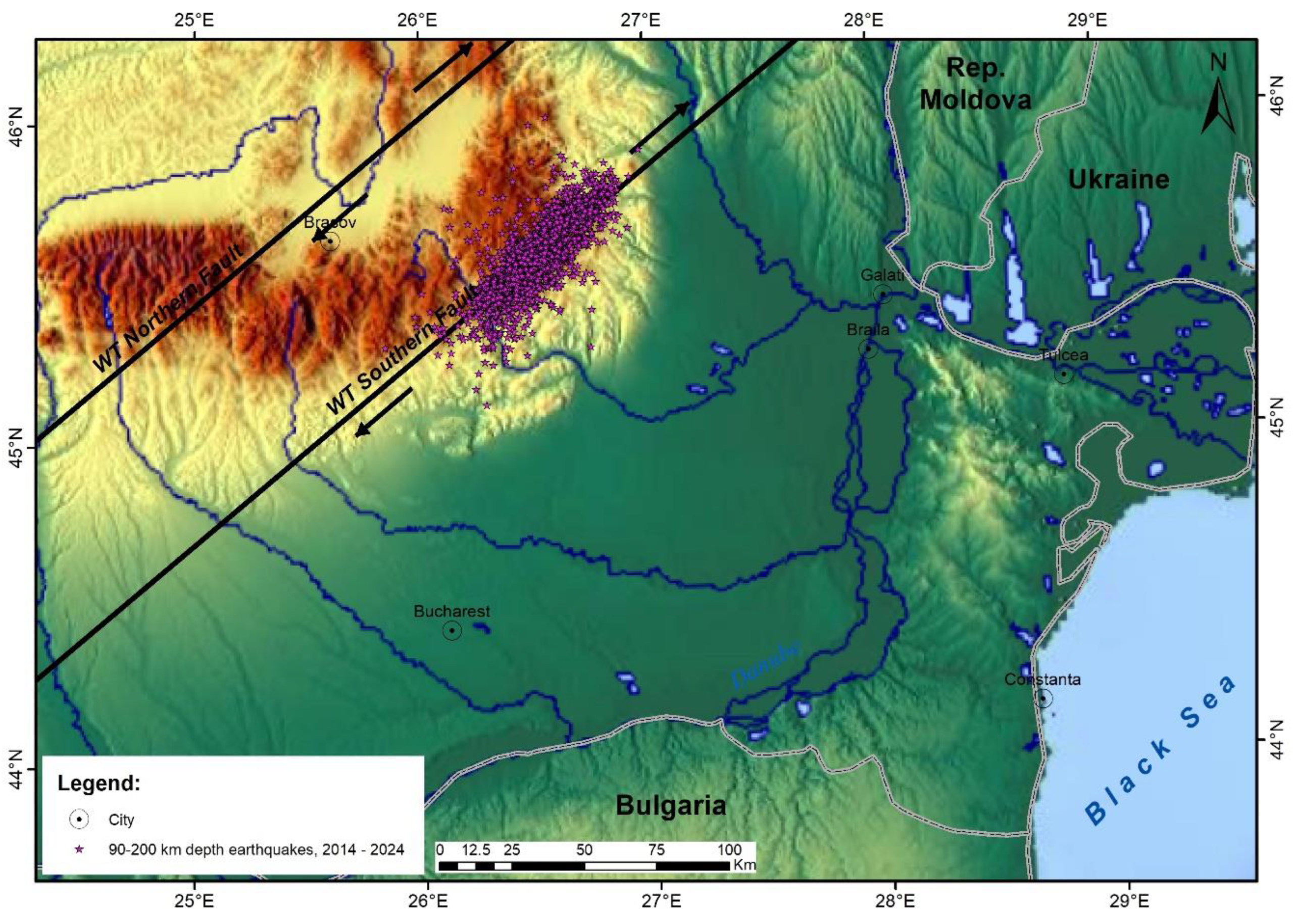
Aiming at separating the seismicity determined by active tectonic structures, such as crustal, subcrustal and lithospheric (intermediate-depth), the seismic events included for the time interval 2014-2024 in the Romanian Earthquake Catalogue - ROMPLUS, and having focii situated at different depths in the Vrancea seismic zone, have been separated for three depth intervals: 0-60 km, 60-90 km, 90-200 km. The resulted maps, displaying earthquake epicenters of each depth interval, are presented in
Figure 2,
Figure 3 and
Figure 4.
The crustal seismicity recorded during 2014-2024 reveals in the Vrancea zone, between 1 and 60 km depth, two clustered lineaments trending NNE-SSW (
Figure 2 – red circle). Both lineaments cross the WT Southern Fault, a transcurrent fault, component of the NE-SW regional wrench system [
3]. These high seismicity clustered zones are considered to be associated with the tectonic contacts of the graben interpreted on refraction seismic data, a Permo-Triassic structure filled with Mesozoic sediments. It was interpreted as the continuation of the Trans-European Suture Zone along the western margin of the East European Platform [
10]. This crustal structure evidenced by seismicity focii between 1 and 60 km depth, illustrated till 50 km depth by refraction seismic [
5] has been reactivated during regional extensional processes [
3].
The subcrustal seismicity, considered to occur in this area between 60 and 90 km depth, depicts a quite compact NE-SW trending seismic sector, developed on ca 30 km along the inner part of the WT Southern Fault (
Figure 3). This high seismicity cluster illustrates that the in-depth Vrancea seismicity is not totally interrupted at mid-lithospheric depths, as considered by most seismicity analyses. The 60-90 km depth high seismicity sector overlaps the Vrancea high airborne magnetic anomaly, this depth interval being probably situated beneath the dioritic batholith interpreted here to reach the top of the crystalline basement [
2].
The seismicity represented by focii of recorded seismic events between 90 and 200 km depth during 2014-2024 is dominated by a NE-SW trending clustered sector (
Figure 4). The evident association between this high seismicity sector and the WT Southern Fault is due to the fact that this tectonic feature was interpreted using the elongated clustered zone, which suggested the presence of a deep fault. In case this assumption is correct, this fault interpreted as an active transcurrent one, is cutting the geological structures from the surface till the deepest lithospheric level.
3. Regional Geodynamics
Vrancea seismic zone is located in a region where active geodynamics, developed during the Miocene by the collision between the African Plate and the Eurasian Plate (e.g., [
11]), led to subduction and collision processes followed by present day high seismicity, at local or regional scales:
Adriatic Sea: past subduction and subsequent collision related to the WSW-ENE directed compressional regime determined by the Apulia microplate. High seismicity occurring in the Durres-Shkoder zone;
East Carpathians: NNW-SSE migrating subduction areas related to the eastward tectonic lateral escape, determined by the collision between Apulia microplate and Europe during the Miocene. The high compressional regime had as consequence the displacement of the Tisza-Dacia tectonic block toward the East European Platform. The subductions and collision processes, directed NE-SW, E-W and finally SE-NW, led to Neogene-Quaternary volcanism in the Calimani-Gurghiu-Harghita magmatic belt and high seismicity in the Vrancea zone;
Hellenic Arc: present day subduction processes caused by the S-N displacement of the African Plate beneath the Eurasian Plate in the region of the Aegean Sea, volcanism occurring in several Aegean islands and seismicity in Greek islands and continental Greece.
The graben geological structure interpreted on the refraction seismic model [
5] is considered to represent the prolongation of the Polish Trough along the East European Platform western margin. It probably continues southward the Trans-European Suture Zone (TESZ), associated with what was recently considered as the Romanian Trough [
2,
10]. The continuation of the Polish Trough till the East Carpathians Bend Zone, meaning Vrancea area, along the East European Platform western margin, is only possible if the Moesian Platform eastern compartment belongs to the East European Platform.
The regional wrench tectonics system, as it was recently interpreted and utilized in regional studies [
2,
3,
6], was probably initiated during the Pannonian, as a consequence of the compressional tectonic regime climax determined by the Apulia microplate collision with the Eurasian plate, followed by eastward tectonic lateral escape, collision and docking processes in the East Carpathians during the Sarmatian. It is considered that the location of the wrench tectonics system developed NE-SW across Romania, is conditioned by the northern limit of the Hellenic Arc subduction zone, presently situated beneath southern Bulgaria, as interpreted on seismic tomography data [
12] by [
6].
An important tectonic event occurred during the Miocene in this region, after Apulia microplate collided with Europe, resulting in a tectonic lateral escape and intense W–E directed compressional regime, was the break of a block of the East European lithosphere western margin. This block is of ca 200 km long and 250 km thick, as may be interpreted on seismic tomography crossection [
12]. The East European Platform southwardly displaced ruptured tectonic block, includes the southern part of the East Carpathians and the East Carpathians Bend Zone, which is hosting the Vrancea seismic zone.
Present day geodynamic processes, as illustrated by GPS monitoring results, show a south-eastward displacement of the East Carpathians Bend Zone and its foreland (e.g., [
13,
14]). A crustal stretching of 10 to 15 km, due to southeastward regional extensional processes, was illustrated in the Vrancea seismic zone by refraction seismic data [
5].
4. Geology, Tectonics and Volcanism
4.1. Geology of the Vrancea Seismic Area
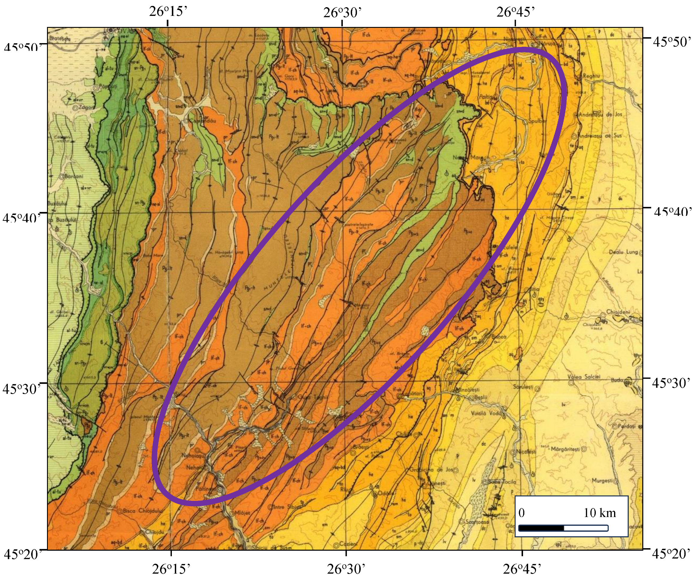
Vrancea seismic area is located at the East Carpathians Bend Zone, in an area where geological mapping showed that the main geological structures and fault systems are abruptly changing strike from NNW-SSE to NE-SW (
Figure 5).
The crystalline basement does not outcrop in Vrancea, being situated at more than 10 km depth, as shown by refraction seismic data (e.g., [
5]).
The sedimentary cover, which has been geologically mapped or investigated by boreholes, consists of tectonic sedimentary nappes overthrusted during the Miocene, the dominant facies being represented by flysch [
15]. The sedimentary formations presented in
Figure 5 [
16], overthrusted from W to E in the Vrancea seismic zone, belong to the Tarcau, Marginal Folds and Subcarpathian sedimentary nappes. Their geological ages are varying from Lower Cretaceous to Helvetian or Tortonian (Badenian), the latter depending on the area where the East Carpathians formations are in contact with those belonging to the East European Platform sedimentary cover. Along the Casin-Bisoca Fault, trending approximately N-S in the geological map north-eastern part, the sedimentary formations within the Subcarpathian Nappe interact with the East European Platform sedimentary cover. The sedimentary formations on both parts of the Casin-Bisoca Fault are close to vertical, suggesting the presence of a tectonic contact suite of a high compressional regime exerted eastward by the East Carpathians geological structures.
The structure of the sedimentary nappes in the Vrancea area shows a number of anticlines and synclines, elongated N-S at the northern part of the area and NE-SW at its southern part, crossed by reverse faults and overthrusting lineaments, indicating a highly tectonized area in a compressional regime (
Figure 5).
The area of high magnitude intermediate-depth seismicity, occurred below 100 km depth during 2014-2024, as shown in
Figure 5, is overlapping a zone of highly tectonized sedimentary formations belonging to the East Carpathians tectonic nappes. The fault system illustrated in the geological map display the same trending as the high seismicity zone.
4.2. Tectonics in and Around the Vrancea Seismic Zone
A significant part of the geological debates related to the Vrancea high subcrustal seismicity has been the following question: which platform was involved in the subduction processes, Moesian Platform or the East European Platform?
- a)
Moesian Platform was considered as being eligible since its eastern compartment is situated beneath the Vrancea zone;
- b)
East European Platform was considered a good candidate since it was involved in subduction along the East Carpathians, being developed at crustal and lithospheric depths beneath this mountainous chain. Numerous scientific projects and published scientific papers discussing subduction and post-subduction collision processes in the Vrancea zone interpreted that the East European Platform has been involved in regional tectonic processes of this kind.
We consider that the East European Platform, part of the Eurasian plate, is developed southwestward as the eastern compartment of the Moesian platform (e.g., [
2,
17]). This south-western promontory of the East European Platform was involved in SE-NW directed subduction in the Vrancea zone, having the Tisza-Dacia tectonic block as the overriding microplate.
A geophysical support for considering the eastern Moesian compartment as part of the East European Platform is represented by the gravity stripped map of Romania [
18]. When aiming at locating the East European Platform western margin [
17] an important boundary has been interpreted at lithospheric depths. It may be useful to mention that the inclined westward platform deepening means different boundary location for a certain depth. The platform western boundary, interpreted on stripped gravity data, crosses the Romanian territory from NW to SE, west of East Carpathians and further southward, along the Intramoesian Fault, the tectonic contact between the two compartments of the Moesian Platform.
The eastward compressional regime during the Miocene, after Apulia microplate collided with Europe, generated sedimentary nappes in the East Carpathians. A significant tectonic consequence of this high compressional regime was the Wrench Tectonics system [
3], that has been probably initiated during the Lower Pannonian [
2].
A seismic tomography study dedicated to the Vrancea seismic zone [
19] interpreted a post-subduction continent-continent collision on a crossection trending NW-SE. It seems that the intense tectonic compressional regime, determined by the Apulia microplate collision with Europe and subsequent tectonic eastward lateral escape, was able to bend the East European Platform forefront and to progressively deepen it, together with the Tisza-Dacia crustal geological structures.
What has been considered, especially during the 1990, when interpreting seismic tomography or magnetotelluric data, that an oceanic slab generated the Vrancea high seismicity, is here interpreted to represent the bent to vertical East European Platform forefront, due to intense continent-continent collision processes. We believe that the oceanic slab resulted from subduction in Vrancea zone is easier interpreted on higher resolution seismic tomography data [
12] as a vertical thinner feature attached to the East European Platform and engulfed in the upper mantle between 350 and 700 km depths.
The high gravity anomaly depicted in Vrancea on the gravity stripped map [
18] and contoured at the East European Platform south-western promontory is probably generated by the high-density rocks platform forefront, bent to vertical, and shown to develop beneath Vrancea at depths between 200 and 350 km [
12,
20].
4.3. Fault Systems
During the last three decades active tectonics involving faults and fault systems was not taken into consideration when building crustal and lithospheric models aiming at explaining the high seismicity in Vrancea zone. This unusual situation may have two main reasons:
- a)
the intermediate-depth high magnitude earthquakes occur many times deeper than 100 km depth;
- b)
the western European scientists which studied Vrancea high seismicity within geological and geophysical projects, especially carried out during the 1990, built tectonic models upon their previous experience, using subduction and continent collision processes, and oceanic slab suite of oceanic lithosphere subduction or continental lithosphere delamination.
Prior to the very vivid scientific activity around and within Vrancea area carried out a few decades ago, Romanian geocientists, either geologists or geophysicists, imagined during the 1970 and 1980 the presence of deep faults beneath Vrancea associated with a Benioff-type plane, as early plate tectonics concept stated [
21,
22].
In spite of absence, at our knowledge, of published detailed geological maps in Vrancea, the geological map at scale 1: 200,000 (
Figure 5) may be used to get information about outcropping fault lines, mostly reverse faults, cutting the overthrusted sedimentary formations. Above the subcrustal seismic Vrancea zone this fault system changes abruptly the trend from N-S to NE-SW.
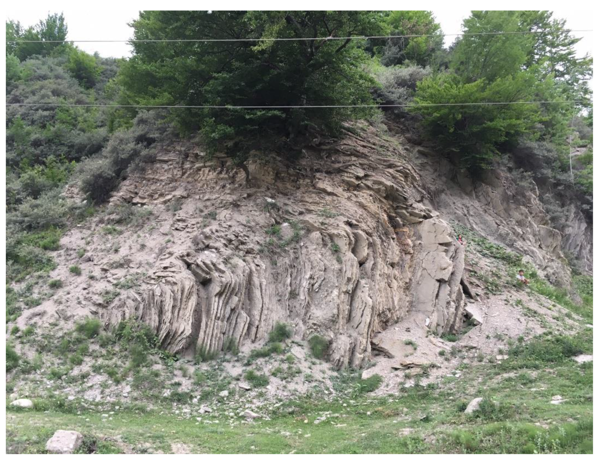
Geological observations carried out in this area noticed outcropping highly tectonized sedimentary formations (
Figure 6) [
23].
A new possibility to consider deep active faulting in Vrancea, after the gap determined by the “slab” tectonic models, has been offered by the interpretation of a wrench tectonics system [
3] crossing this high seismicity zone. The two regional strike-slip faults are active and supposed to cut the entire lithosphere in Vrancea. The tectonic models built since 2018 by our research team interpret the intermediate-depth high magnitude seismicity associated with the wrench tectonics system southern fault (WT Southern Fault) in a transtensive tectonic regime [
2,
4,
6].
In the framework of the wrench tectonics system, where two transcurrent faults trending NE-SW, WT Southern Fault and WT Northern Fault, are crossing the Vrancea seismic zone, the detailed analysis of local seismicity suggests that there are also NW-SE trending faults in this area.
4.4. Volcanism in the Vrancea Zone
Most geological studies carried out in Vrancea seismic zone considered that volcanism or intrusive magmatic processes did not manifest in this area, probably because magmatic structures do not outcrop.
Old geological studies published by Romanian scientists during the 1970 considered, using the tectonic plates concept (e.g., [
24,
25]), that subduction of oceanic lithosphere generates volcanism and magmatism in the overriding plate, and included magmatic intrusions in models built for the Vrancea zone.
C. Roman [
26], a geophysicist who first used plate tectonics in Vrancea, included in the tectonic model andesitic lavas and magmatic intrusions, while a decade later I. Cornea and V. Lazarescu [
22] included a large and deep magmatic intrusion in the tectonic model built for the Vrancea zone.
Recent reinterpretation of geophysical and geological data offered the possibility to look for traces of past volcanic processes, a result of subduction processes beneath the Vrancea zone, in order to locate buried magmatic structures covered by East Carpathians sedimentary nappes. Geophysical and geological information have been analyzed and reinterpreted in view of getting data on past magmatic processes in Vrancea:
- a)
aeromagnetic anomaly in the Vrancea zone;
- b)
hydrothermal genesis of the Jitia metallic sulphides;
- c)
hydrogeological observations.
4.4.1. The aeromagnetic anomaly in the Vrancea zone [
27], trending NE-SW and located in the area limited by the WT Southern Fault and WT Northern Fault, is interpreted to be mainly determined by a deeply located magmatic structure. It is considered that the magmatic intrusion is of dioritic petrographical composition, since diorites are the most magnetic intrusive rocks. The postulated magmatic intrusion possibly reaches the upper limit of the Tisza-Dacia tectonic block crystalline basement. Depth evaluation from the surface to the top of magmatic structure, using the magnetic anomaly characteristics, indicated ca 15 km depth, in good agreement with what is considered to be the thickness of the sedimentary cover. The aeromagnetic anomaly, that is covering ca 200 km
2, as well as its intensity, suggest that the large dioritic intrusion may be considered a batholith.
It is likely that the interpreted dioritic batholith has been intruded beneath the Vrancea zone during the Late Pliocene, probably during the Romanian. The northeastern boundary of the geophysical interpreted Vrancea batholith coincides with the Casin-Bisoca Fault. The area where the magmatic batholith was intruded has been affected by the SW-NE displacements determined along the north-western side of the WT Southern Fault, generating intense faulting in the Subcarpathian Nappe and East European Platform sedimentary cover, in the area crossed by the Casin-Bisoca Fault.
4.4.2. The interpretation provided by T.P. Ghitulescu and M.G. Filipescu after studied the Jitia zone concluded that the genesis of the Pb-Zn sulphides occurrences is hydrothermal [
28]. Jitia area is situated in the Vrancea zone, between the Bisoca-Casin and WT Southern faults; this sector affected by past and present day active tectonics, due to active strike-slip faulting, has been easily penetrated by upwelling hydrothermal fluids originating from the deep magmatic structure.
4.4.3. Hydrogeological evidence for the presence of a buried intrusive magmatic structure in the Vrancea area is considered to be represented by the occurrence of geothermal groundwater. At the south-western limit of the subcrustal Vrancea seismic zone an emergence of thermal water (temperature between 30 and 60 degrees Celsius) have been detected at Siriu [
29] and presently employed as a natural spa.
5. Causes of High Magnitude Earthquakes in Vrancea
5.1. Crustal and Lithospheric Seismicity
The analysis of the high seismicity recorded in the Vrancea zone during 2014–2024 led to the following seismotectonic interpretations:
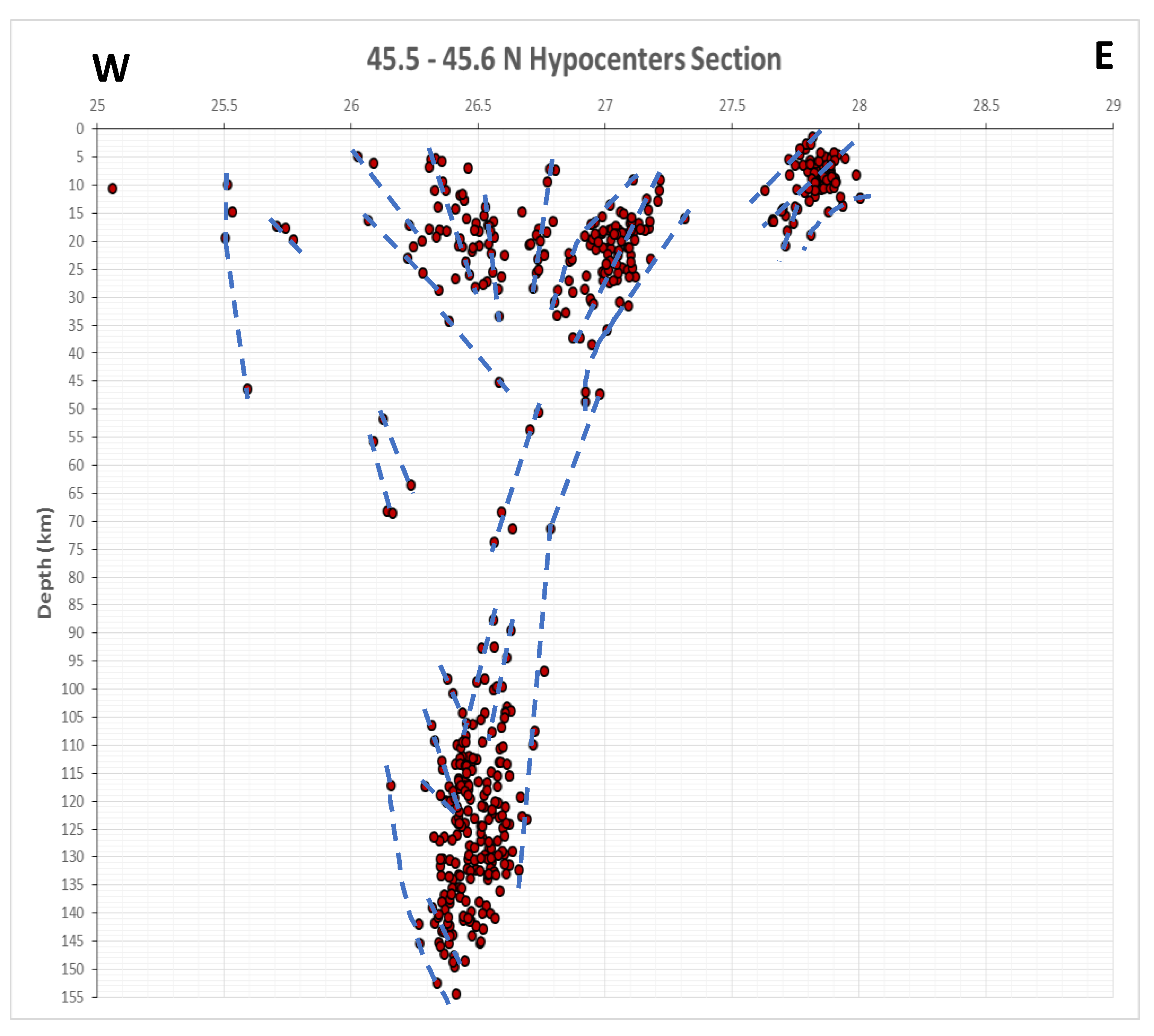
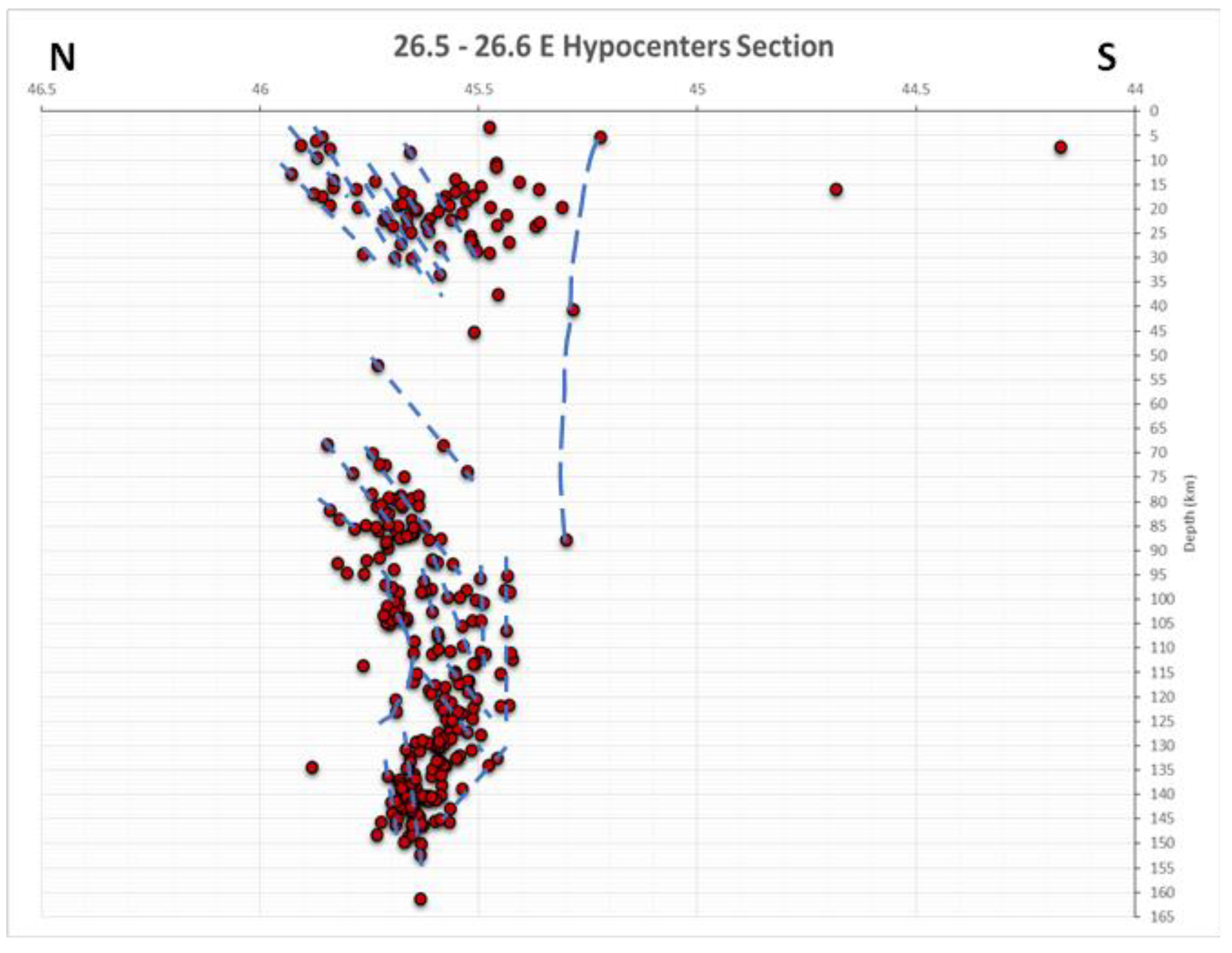
the highest seismicity in Vrancea has been observed at the intersection zone between WT Southern Fault, trending NE-SW, and the NW-SE trending fault system, all faults being active and having strike-slip characteristics. At crustal depths the graben geological structure, detected by refraction seismic and illustrated by high seismicity till 60 km depth (
Figure 2), has been reactivated by SE directed extensional tectonic processes, partly determined by geodynamic processes related to the eastward displacements of the northern compartment along the North Anatolian Fault.
seismicity sections, built till 160 km depth in Vrancea zone, may be interpreted as being associated with active extensional tectonics especially at crustal depths. At the deepest lithospheric depths the main tectonic processes, leading to intermediate-depth high magnitude earthquakes, are related to transtensional processes along the WT Southern transcurrent fault (
Figure 7 and
Figure 8) [
3].
We consider of highest importance for the intermediate-depth strong seismic events in Vrancea that the East European Platform was interpreted on seismic tomography crossections to be thick of ca 200 km. Considering that the Vrancea deep seismicity is recorded at depths ranging between 80 and 170 km depth, and that the East European Platform is here situated beneath the Tisza-Dacia tectonic block after subduction, collision and docking processes ended, it should be obvious that the intermediate-depth earthquakes occur within the East European Platform. This situation was already suggested more than two decades ago, in a paper dedicated to subduction areas in Europe, where the intermediate-depth Vrancea seismicity (80-170 km depth) is clearly located in a high seismic velocity anomaly structure, normally interpreted as the subducted East European Platform [
20].
The “oceanic lithospheric slab” was considered in numerous studies referring to the Vrancea seismic zone, as being totally or partially attached to the East European Platform and causing the subcrustal Vrancea seismicity. However, when interpreting recent seismic tomography data it turned out that “the oceanic slab” employed in many tectonic models in papers dedicated to Vrancea seismicity, and which develops in-depth between 200 and 400 km with thickness of 150 to 200 km, does not represent the real subducted oceanic slab. This deeply located tectonic structure represents in fact the bent to vertical forefront of the East European Platform, suite of intense continent-continent tectonic collision, and cannot be directly involved in the Vrancea subcrustal seismicity due to its depth location. The real oceanic slab that was subducted beneath Vrancea area is attached in a vertical position to the East European Platform south-western promontory and is situated much deeper, between 400 and 700 km depth. This “real slab” thickness is interpreted on seismic tomography data to be ca 50 km [
12,
20], quite normal considering the oceanic lithosphere thickness.
Crustal seismicity in the Vrancea zone is here considered to be related to active normal faulting associated to the graben structure. This tectonic structure possibly represents a prolongation of the Polish Trough into Vrancea [
10], continued southward along the western margin of the East European Platform situated beneath the East Carpathians. When plotting the crustal seismicity on E-W and N-S lineaments across the Vrancea zone, normal faults may be interpreted using the hypocenters of seismic events (
Figure 7 and 8, crustal depths).
Subcrustal high seismicity in Vrancea is considered to be caused by strike-slip movements along the wrench tectonics transcurrent fault (WT Southern Fault) in a transtensional regime, as suggested in
Figure 7 and
Figure 8, on E-W and N-S lineaments, at subcrustal depths. WT Southern Fault is cutting the East European Platform south-westernmost bent promontory at depths between 80 and 200 km. The mechanical properties of the East European Platform forefront have been changed as compared to the neighboring area situated between the transcurrent faults, due to thermal metamorphism occurred during the batholith magma upwelling and cooling at upper crustal depths.
The eastern bending of the WT Southern Fault at subcrustal depths, as shown in
Figure 8, may represent a remnant of past compressional regime occurred during the Sarmatian in this region.
5.2. Causes of High Magnitude Earthquakes in Vrancea Seismic Zone
The transcurrent WT Southern Fault trending NE-SW is tectonically involved in the intermediate-depth high magnitude seismicity, vertically “cutting” the East European Platform SW promontory and determining horizontal displacements of its compartments. The similarity in trending and overlapped area of this deeply located high seismicity sector (
Figure 4) with that of outcropping sedimentary formations and associated reverse fault system (
Figure 5) suggests that after the post-subduction collision and docking the platform and the overriding tectonic block responded as a single geological body to active geodynamic and tectonic processes.
The deep high seismicity in Vrancea, occurring between 80 and 170 km depth, have been recently interpreted to happen at the junction between the WT Southern Fault with a NW-SE trending fault system, but no geologically known fault system was available in that area at that time [
2].
The continuation of the NW-SE trending regional faults mapped in the region of Dobrogea,
situated between Danube and the Black Sea, has been interpreted a few decades ago west of Danube,
using only borehole and geophysical information, due to lack of geological outcrops. At that time,
the interpretation of gravity data on the whole Romanian territory in terms of regional fault systems
[
30], offered the continuation of the NW-SE Dobrogean fault system beyond Danube. The crustal
faults Peceneaga-Camena and Capidava-Ovidiu have been traced at that time in the published map
to change their trend from NW-SE to NNW-SSE west of Danube. Peceneaga-Camena Fault was
connected with the Siret Fault, continuing this way along the Siret river valley, situated east of the
East Carpathians, to the northern boundary with Ukraine and beyond. The Capidava-Ovidiu Fault
was directed toward the Focsani Depression, outer of the East Carpathians Bend Zone, and ended
after ca 100 km west of Danube. Important papers or books dedicated to regional tectonics in this
region preserved this tectonic solution offered by [
30], at least until the Trotus Fault, none of them
(e.g., [
15,[
31,
32]) continuing these faults north-westward, toward the East Carpathian Bend Zone.
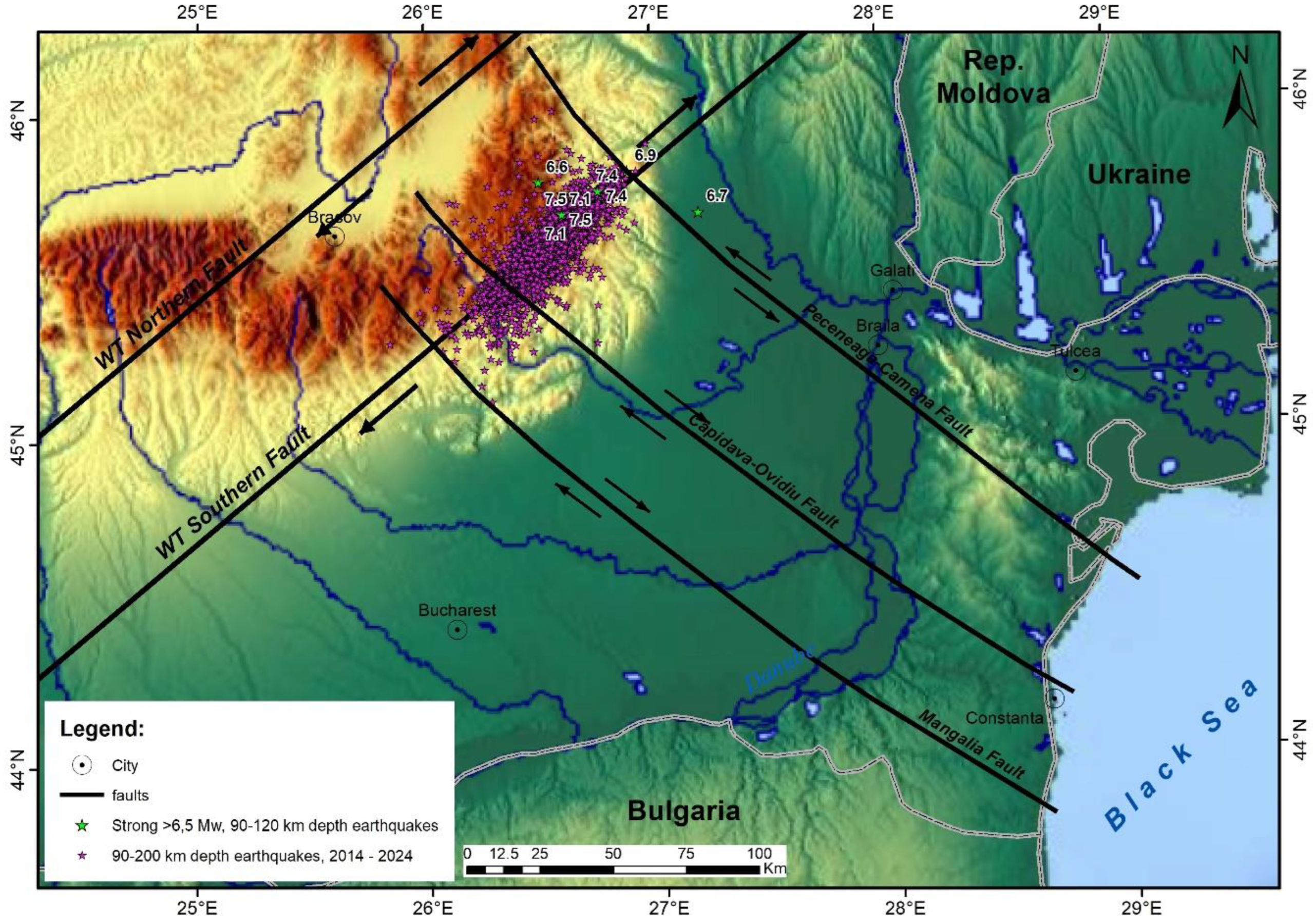
The NW continuation toward the East Carpathians Bend Zone of the Peceneaga-Camena and Capidava-Ovidiu faults has been carried out for the first time, at our knowledge, in this paper. To complete the picture of this NW-SE trending regional transcrustal fault system toward the Vrancea seismic zone the Mangalia Fault [
33] has been added (
Figure 9).
As it may be observed in
Figure 9 the highest magnitude subcrustal seismic events are located in the junction area situated between the WT Southern Fault, the Peceneaga-Camena Fault and the Capidava-Ovidiu Fault. The largest number of high magnitude seismic events is here favored by the south-western rapid bending and deepening of the East European Platform promontory, with consequences in the mechanical properties of its geological formations and the presence of the dioritic batholith, whose magma upwelling and subsequent cooling determined the thermal metamorphism of neighboring rocks. Both aspects are influencing the rupturing processes carried out in this sector by the horizontal displacements along the NE-SW trending strike-slip WT Southern Fault and the NW-SE trending Peceneaga-Camena and Capidava-Ovidiu faults. As it may be observed, all faults depicted in
Figure 9 are considered as active strike-slip faults.
There are still clustered earthquakes between the Capidava-Ovidiu and the Mangalia faults when crossing the WT Southern Fault, but their number and magnitude are decreased in a large extent since there is no thermal metamorphism of lithospheric rocks within that sector.
The lack of seismicity along the WT Northern Fault is due to the absence of intersection with the NW-SE trending fault system, the East European Platform western margin being situated between the two transcurrent faults (
Figure 9).
6. Conclusions
The splitting of the Vrancea seismicity recorded between 2014 and 2024 into three depth intervals (1-60, 60-90 and 90-200 km) illustrated important tectonic and seismogenic structures:
crustal seismicity, determined by normal faults associated with the reactivated crustal graben-like structure, interpreted on refraction seismic, situated between 1 and 60 km depth;
seismicity recorded between 60 and 90 km depth, considered to be associated to the dynamics of the dioritic batholith, along the inner part of strike-slip WT Southern Fault and part of the Tisza-Dacia tectonic block, in collision with the East European Platform along the Casin-Bisoca Fault. It is likely that the surface expression of the Peceneaga-Camena crustal fault is here represented by the Casin-Bisoca Fault, acting as a tectonic contact. The seismic cluster located between 60 and 90 km depth shows that there is no vertical gap in the Vrancea seismicity;
high magnitude seismic events, situated between 90 and 200 km depth, are mainly associated with the wrench tectonics system southern transcurrent fault, the horizontal displacements occurring along this regional strike-slip fault being associated with normal faulting in a transtensional regime.
The East European Platform margin is here interpreted to develop as a southwestward promontory, forming the eastern compartment of the Moesian Platform that has been involved in subduction and collision processes in the Vrancea zone.
For a correct understanding of the geological structure where strong earthquakes occur in Vrancea, of highest significance is the East European Platform thickness, here interpreted to be of ca 200 km. Under such circumstance the straight derived interpretation is that these strong intermediate-depth earthquakes, with depths ranging between 80 and 170 km, occur within the platform and are not associated to an oceanic slab or delaminated lithosphere.
The oceanic lithosphere slab, previously considered, based on seismic tomography and magnetotelluric data, to be attached to the East European Platform in a vertical position, does not really represent the subducted oceanic slab. It represents in Vrancea area the bent forefront of the platform, due to the intense continent-continent tectonic collision in this sector.
The oceanic slab that was considered to be responsible for the Vrancea deeply located seismicity is here considered to be attached to the East European Platform bent forefront, in a vertical position. Its actual location, interpreted here to be situated between 400 and 700 km depth, eliminate this tectonic structure involvement in Vrancea seismicity.
The northwestern continuation of the Peceneaga-Camena and Capidava-Ovidiu transcrustal faults in the East Carpathians Bend Zone has been carried out for the first time in this paper. To complete this NW-SE fault system toward the Vrancea seismic zone, the Mangalia Fault has been added.
The high magnitude intermediate-depth seismic events turned out to be located at the junction between the wrench tectonics system southern part (WT Southern Fault trending NE-SW) and the main NW-SE trending Dobrogean faults (Peceneaga-Camena Fault and Capidava-Ovidiu Fault). There are still clustered earthquakes between the Capidava-Ovidiu Fault and Mangalia Fault, but their number and magnitude decreases rapidly toward SW.
The absence of seismicity along the WT Northern Fault in Vrancea is a result of the fact that this transcurrent fault does not intersect the NW-SE trending Dobrogean fault system, the East European Platform western margin being here situated between the two transcurrent faults.
Author Contributions
Conceptualization, D.I.; methodology, D.I.; investigation, D.I.; software M.S..; resources, D.I., M.S.; data curation, M.S.; writing—original draft preparation, D.I; writing—review and editing, D.I.; visualization, D.I., M.S.; All authors have read and agreed to the published version of the manuscript.
Funding
This research received no external funding.
Data Availability Statement
Acknowledgments
We acknowledge Dr. Irina Stanciu scientific contribution to the development of the Vrancea seismic zone model and mapping efforts within this study.
Conflicts of Interest
The authors declare no conflicts of interest.
References
- Braxmeier, H. Maps-For-Free. Available online: https://maps-for-free.com/ (accessed on 19 July 2025).
- Ioane, D.; Stanciu, I. Vrancea Seismic Zone - A New Geophysical Model Based on Wrench Tectonics, Volcanism and Regional Geodynamics. Rev. Roum. Géophys. / Rom. Geophys. J. 2021, 65, 3–47. [Google Scholar] [CrossRef]
- Ioane, D.; Stanciu, I.M. Extensional tectonics in Vrancea zone (Romania) interpreted on recent seismicity, geophysical and GPS data. In Proceedings of the 18th Int. Multidiscipl. Scient. GeoConf. Earth & Geosciences – SGEM2018, Albena, Bulgaria, Vol. 18, Issue 1.1, Applied and Environmental Geophysics, 2-8 July 2018; pp. 787–794. [Google Scholar]
- Ioane, D.; Stanciu, I. Tectonic and geodynamic model for the Vrancea seismic zone. Proceedings of Geosciences in the 21st century, Bucharest, Romania, Bucharest, Romania, 2019, 22 October 2019; GeoEcoMar Publishing House; Seghedi, A., Mocanu, V., Ilinca, G., Eds.; pp. 91–95, https://www.fluvimar.ro/Abstracte%20Conferinta/GEOSCIENCES%20IN%20THE%2021st%20CENTURY.pdf. [Google Scholar]
- Hauser, F.; Raileanu, V.; Fielitz, W.; Dinu, C.; Landes, M.; Bala, A.; Prodehl, C. Seismic crustal structure between the Transylvanian Basin and the Black Sea, Romania. Tectonophysics 2007, 430, 1–25. [Google Scholar] [CrossRef]
- Ioane, D.; Stanciu, I. Active Tectonics, Transcurrent Faults and High Magnitude Seismicity Zones: Durres (Albania) and Vrancea (Romania). Rev. Roum. Géophys. / Rom. Geophys. J. [CrossRef]
- Radu, C. Le regime seismique de la region de Vrancea. Rev. Roum. Géophys. 1965, 9, 49–64. [Google Scholar]
- Petrescu, L.; Enescu, B. Seismicity of a relic slab: space–time cluster analysis in the Vrancea Seismic Zone. Earth, Planets and Space 2025, 77, 6. [Google Scholar] [CrossRef]
- Romanian Earthquake Catalogue – ROMPLUS. Available online: https://www.infp.ro/index.php?i=romplus (accessed on day month year).
- Ioane, D. , Pantia, A.I., Stanciu, I. The Trans-European Suture Zone in Romania. In Extended Abstracts Volume of GEOSCIENCE 2019 Symposium, Bucharest, Romania, . https://appliedgeophysics.ro/GEOSCIENCE%202019_A3/. 22 November 2020. [Google Scholar]
- Dewey, J.F.; Pitman, C.W.; Ryan, F.B.; Bonnin, J. Plate tectonics and the evaluation of the Alpine system. Geol. Soc. Am. Bull. 1973, 84, 3137–3180. [Google Scholar] [CrossRef]
- van der Meer, D.G.; Hinsbergen, D.J.J.; Spakman, W. Atlas of the underworld: Slab remnants in the mantle, their sinking history, and a new outlook on the lower mantle viscosity. Tectonophysics 2018, 723, 309–448. [Google Scholar] [CrossRef]
- Hefty, J. Geokinematical modelling and strain analysis. In Proceedings of the 3rd CERGOP-2 Conference, Sofia, Bulgaria, Sep. 30-Oct. 1, 2004. Reports on Geodesy 2004, 4, 39–42. [Google Scholar]
- Munteanu, L. The kinematics of the tectonic blocks in the Vrancea area using modern high-precision satellitetechnology. In Researches on the Romanian earthquakes’ disaster management; Marmureanu, G., Ed.; Tehnopress, Iasi, Romania, 2009; pp. 482–546. (in Romanian)
- Sandulescu, M. Geotectonics of Romania. Technical Publishing House, Bucharest, Romania, 1984; 334 p. (in Romanian)
- Dumitrescu, I. , Sandulescu, M., Bandrabur, T. (1970), Geological map sheet 29 (Covasna), scale 1: 200,000. Geological Institute, Bucharest. Maps-For-Free. Available online: https://geo-spatial.
- Ioane, D.; Caragea, I. Western boundary of the East European Platform in Romania as interpreted on gravity and magnetic data. In Proceedings of the 8th Congress of the Balkan Geophysical Society, Chania, Greece, 4-8 October 2015. [Google Scholar] [CrossRef]
- Ioane, D.; Ion, D. , A 3D crustal gravity modeling of the Romanian territory. Journal Balkan Geophysical Society 2005, 8, 189–198. [Google Scholar]
- Fan, G.; Wallace, T.C.; Zhao, D. Tomographic imaging of deep velocity structure beneath the Eastern and Southern Carpathians, Romania: implications for continental collision. Journ. Geophys. Res. 1998, 103, 2705–2723. [Google Scholar] [CrossRef]
- Wortel, M.J.R.; Spakman, W. Subduction and Slab Detachment in the Mediterranean-Carpathian Region. Science 2000, 290, 1910–1917. [Google Scholar] [CrossRef] [PubMed]
- Constantinescu, L.; Constantinescu, P.; Cornea, I.; Lazarescu, V. Recent seismic information on the lithosphere in Romania. Rev. Roum. Géophys. 1976, 20, 33–49. [Google Scholar]
- Cornea, I.; Lazarescu, V. Geology and seismotectonics of Romania. In The earthquake of March 4, 1977 in Romania, Balan, S., Cristescu, V., Cornea, I., Eds.; Romanian Academy Publishing House, Bucharest, Romania, 1982; pp. 19–35. (in Romanian)
- Ioane, D.; Nutu-Dragomir, M.-L.; Diacopolos, C.; Stochici, R.; Stanciu, I.M. Looking for regional faults crossing Vrancea seismogenic zone. In Extended Abstracts Volume of GEOSCIENCE 2018 Symposium, Bucharest, Romania, . https://www.researchgate. 16 November 3290. [Google Scholar]
- Le Pichon, X.; Francheteau, J.; Bonnin, J. Plate Tectonics, Developments in Geotectonics, 6; Elsevier, Amsterdam, Netherlands, 1973; 300p.
- Kearey, P.; Klepeis, K.; Vine, F. Global Tectonics, 3rd ed.; Wiley-Blackwell Publishing House, Chichester, U.K. 2009. Available online: https://www.geokniga.org/bookfiles/geokniga-global-tectonics.pdf (accessed on 19 July 2025).
- Roman, C. Seismicity in Romania – evidence for a sinking lithosphere. Nature 1970, 228, 1176–1178. [Google Scholar] [CrossRef] [PubMed]
- Cristescu, Tr.; Stefanciuc, Al. Aeromagnetic surveys in Pannonian Depression, Apuseni Mts., East Carpathians, South Carpathians, Moesian Platform, Dobrogea, Transylvanian Depression, Moldavian Platform, Prospectiuni S.A. Archive, 1962-1968, Bucharest, Romania. (in Romanian)
- Cioflica, G.; Atanasiu, N.; Berbeleac, I.; Bita, I. Genesis of sulphide mineralization related to the Miocene molasse at Jitia (East Carpathians). Rev. Roum. Geol. 1986, 30, 3–20. [Google Scholar]
- Bandrabur, T.; Ghenea, C.; Ghenea, A. Craciun, P. Map of mineral and geothermal groundwater in Romania, scale 1: 1,000,000. Institute of Geology and Geophysics, Bucharest, Romania, 1981. (in Romanian)
- Gavat, I. , Airinei, S., Botezatu, R., Socolescu, M., Stoenescu, S.,The deep structures of the Romanian territory interpreted on recent geophysical data (gravity and magnetics). Stud. Cerc. Geofiz. 1963, 1, 7–30. (in Romanian). [Google Scholar]
- Visarion, M. , Sandulescu, M., Stanica, D., Veliciu, S., Contributions a la connaissance de la structure profonde de la plateforme Moesienne en Roumanie. Studii Tehnice si Economice 1978, 15, 211–222. [Google Scholar]
- Visarion, M. , Besutiu, L., Transcrustal faults on the Romanian territory. Studii si Cercetari, Geofizica 2001, 39, 15–33. [Google Scholar]
- Paraschiv, D.; Danet, N.; Popescu, M.; Dumitrescu, V. The present stage of pre-Jurassic deposits knowledge in South Dobrogea. Annuaire de l’Institut de Geologie et de Geophysique 1983, 59, 29–37. [Google Scholar]
|
Disclaimer/Publisher’s Note: The statements, opinions and data contained in all publications are solely those of the individual author(s) and contributor(s) and not of MDPI and/or the editor(s). MDPI and/or the editor(s) disclaim responsibility for any injury to people or property resulting from any ideas, methods, instructions or products referred to in the content. |
© 2025 by the authors. Licensee MDPI, Basel, Switzerland. This article is an open access article distributed under the terms and conditions of the Creative Commons Attribution (CC BY) license (http://creativecommons.org/licenses/by/4.0/).