Submitted:
04 October 2025
Posted:
07 October 2025
You are already at the latest version
Abstract
Efficient last-mile delivery remains a major challenge for agriculture in rural regions such as the state of North Dakota in the United States. In these regions, farms are large, dispersed, and dependent on timely access to inputs. Truck–drone hybrid systems offer a potential solution by combining the long-haul capacity of trucks with the speed and flexibility of drones. Economic studies indicate that such proposed hybrid systems can enable faster, lower-cost, and more sustainable delivery of small, time-critical packages. This research further reviews the role of geographic information systems (GIS) in enabling these systems. A combined systematic and thematic review of 82 high-quality publications identifies five domains: GIS applications, truck–drone coordination, smart agriculture integration, rural implementation, and sustainability impacts. The findings show that GIS supports route optimization, drone launch-site selection, and real-time monitoring. Beyond the capacity of drones to extend reach and reduce delays, integrating IoT and AI platforms enhances decision-making and improves efficiency. However, constraints include federal regulations, payload limits, harsh weather (especially in rural areas), and cybersecurity risks. This review concludes that GIS-enabled truck–drone systems can transform agricultural logistics and rural resilience if providers can address regulatory, technical, and security challenges through coordinated innovation.
Keywords:
truck–drone delivery
; GIS
; agricultural logistics
; last-mile delivery
; rural transportation
; precision agriculture
; IoT
; smart farming
; sustainability
; supply chain resilience
1. Introduction
Last-mile delivery is the most expensive and complex stage of agricultural logistics. The challenge is especially severe in vast rural areas like the state of North Dakota in the United States. There, farms spread across 38.5 million acres and average more than 1,500 acres each. With about 26,800 farms, long distances separate production sites from supply centers. Reliance on trucks alone increases costs, extends delivery times, and elevates emissions, particularly during critical planting and harvest windows [1].
Hybrid truck–drone systems offer a promising alternative. Trucks provide long-haul capacity, while drones handle fast, short-range deliveries directly to farms. This division of roles reduces delivery times and expands service reach [2]. Drones provide flexible payload capacity from a few pounds to several thousand pounds, depending on their size [3]. Yet their deployment remains constrained by regulations and operational limitations in inclement weather [4]. Restrictions on beyond-visual-line-of-sight (BVLOS) operations by government agencies, combined with North Dakota’s harsh winter conditions, require new strategies to ensure operational reliability.
Geographic information systems (GIS) are central to these strategies. GIS enables route optimization, spatial decision-making, and real-time monitoring by integrating maps of farm locations, road networks, and field boundaries. It identifies suitable launch and landing sites, designs recharge infrastructure, and fuses environmental data into dynamic delivery planning [5]. In agriculture, GIS demonstrates its versatility through the support of soil and crop suitability mapping, irrigation planning, and precision farming [6].
The convergence of drones and GIS extends this potential. Smart farming platforms, based on Internet-of-Things (IoT) technologies, now integrate sensors, cloud analytics, and autonomous machinery to monitor conditions and automate inputs [7]. When combined with drones and GIS, these systems strengthen logistics by linking delivery operations with real-time farm needs. Such integration advances both efficiency and sustainability [8].
This study reviews the role of GIS in enabling truck–drone hybrid systems for agricultural last-mile delivery. It presents North Dakota as a representative case of dispersed farms and harsh rural environments. The review examines how GIS supports routing, scheduling, and monitoring. Furthermore, it identifies technological and operational challenges and evaluates economic and environmental benefits. This work also considers cybersecurity, policy frameworks, and the broader role of these systems in rural resilience [9].
The review addresses the following three guiding questions:
- How can organizations effectively implement GIS-based truck–drone systems in North Dakota to enhance agricultural logistics?
- What technological and operational challenges constrain deployment of these systems in dispersed, cold-weather environments?
- What economic and sustainability benefits can farmers achieve compared with truck-only methods?
In addressing the above questions, this study comprehensively integrates interdisciplinary research situated at the intersection of geospatial analytics, unmanned aerial systems, and agricultural logistics. This includes IoT connectivity, adaptive routing algorithms, spatial infrastructure design, and critically assessing systemic barriers.
The remainder of the paper presents the methodology for the review (section 2), synthesizes findings in the results (section 3), extrapolates implications in the discussion (section 40, and outlines research priorities before concluding (section 5) with policy and practice recommendations.
2. Methodology
This study employed a systematic and multidisciplinary literature review, combined with a thematic analysis, to synthesize knowledge at the intersection of geoinformatics, intelligent transportation systems, precision agriculture, and rural logistics. The primary objective was to assess how geospatial technologies and hybrid truck–drone delivery models collectively address infrastructural, environmental, and operational challenges in agriculture.
The structured bibliographic search strategy illustrated in Figure 1 guided the review process. It follows the Preferred Reporting Items for Systematic Reviews and Meta-Analyses (PRISMA) guidelines, widely recognized by scholars for its transparency, rigor, and replicability [10]. The search queried four major academic databases: Scopus, Web of Science, ScienceDirect, and SpringerLink. The query command utilized a Boolean search with the following logic:
(“truck-drone*” OR “UAV” OR “GIS” OR “geographic information systems” OR “IoT”) AND (“last mile” OR “logistics” OR “delivery”) AND “agricult*” AND “rural”
where the wild-card character “*” represents any alternative ending. To capture recent developments, the review focused on peer-reviewed English language publications from the last decade.
The initial search retrieved 519 records, which the duplicate removal process reduced to 482 unique studies. A two-stage screening process followed. The first stage applied inclusion and exclusion criteria to titles and abstracts. The process retained studies if they addressed two core themes from among the following: (1) GIS applications in agriculture, (2) hybrid truck–drone logistics, (3) spatial data analysis for route optimization, or (4) integration of digital agriculture technologies in rural delivery systems. This step produced a refined set of 203 articles.
The second stage applied a quality appraisal protocol (QAP) to evaluate methodological rigor and relevance. The QAP employed eight assessment criteria, as summarized in Table 1. These criteria were GIS integration, hybrid truck–drone technology, last-mile delivery to support agriculture, spatial optimization, use of empirical or quantitative methods, rural contexts, sustainability metrics, and integration of IoT or digital agriculture tools. This step retained 82 high-quality publications for reviewing the full text.
A thematic coding framework, combining inductive and deductive approaches, then classified the studies into the five thematic domains, as summarized in Table 2. These were (1) GIS applications and spatial analytics, (2) truck–drone system coordination, (3) smart agriculture technology integration, (4) rural infrastructure and implementation, and (5) sustainability and economic impact assessment. This framework enabled structured synthesis and facilitated cross-comparison of strategies, models, and outcomes across different regions and technological ecosystems.
To complement the review, this study conducted a term co-occurrence analysis using the tool VOSviewer version 1.6.20 [11]. The tool extracted key terms from titles and abstracts of the selected publications and mapped their relationships based on frequency and co-occurrence strength. The resulting network visualization organized terms into color-coded clusters. The size of each node in the network reflects term frequency, and the thickness of lines connecting nodes indicates the strength of association. This network visualization highlights dominant themes and shows how they interconnect across disciplinary boundaries. By identifying thematic clusters and cross-linkages, the co-occurrence analysis provided insights into the intellectual structure of research on GIS-enabled truck–drone hybrid systems and highlighted the areas where technological, environmental, and operational considerations converge in agricultural logistics.
3. Results
The approach of combining systematic search protocols, multi-criteria evaluation, and thematic categorization, including a term co-occurrence network and clustering, ensured a rigorous review process with multidisciplinary contexts. The outcome was a comprehensive foundation that distilled both strategic insights and technical considerations relevant to researchers, policymakers, and agricultural practitioners seeking to advance GIS-enabled truck–drone logistics. The review identified five recurring domains: GIS analytics, truck–drone coordination, smart-agriculture technology integration, rural implementation, and sustainability and/or economic impacts. Studies spanned algorithms, field deployments, and policy analyses that collectively inform last-mile delivery in agriculture. Table 3 summarizes the main theme of the reviewed corpus into seven topics.
Figure 2 complements the topic categorization by showing a term co-occurrence network that highlights the main research themes linking GIS, drones, and agricultural logistics.
The network shows 44 terms that had at least five co-occurrences across the corpus, forming six clusters. The green cluster centers on the term “drone” with occurrences in 54 articles and 26 links to central terms such as delivery, last mile delivery, emission, cost, demand, and medical supply. These connections reflect operational and environmental aspects of drone-based logistics. The red cluster centers on the term “GIS” with occurrences in 33 articles and 24 links to terms like “geospatial technology. “information. “management. “soil. and “decision making.” This cluster highlights the role of spatial analysis and data-driven planning. The dark blue cluster focuses on the term “data” with occurrences in 44 articles and links to 38 terms like “field. “environment. “land. and “performance.” These indicate strong connections between geospatial datasets, environmental monitoring, and precision farming. The purple cluster centers on the term “internet” with occurrences in 24 articles and 25 links to terms like “smart farming. “communication technology. and “UAV.” These relationships highlight the integration of IoT and connectivity tools with drone applications. The yellow cluster centers on the term “productivity” with occurrences in 22 articles and 32 links to terms like “agricultural practice. “future. “food. “artificial intelligence. and “precision farming.” These relationships reflect how current and emerging technologies are influencing farm productivity and resource use. The light blue cluster focuses on the term “sustainability” with a strong connection to the term “logistic” as well as cross-links to terms in other clusters such as “field. “data. “internet. and “management.” These cross-connections highlight the leading role of sustainability as a concept bridging operational logistics, technological integration, and data-driven decision-making. Together, the clusters reveal that research converges on combining drones, GIS, and smart technologies to improve sustainability, efficiency, and decision-making in agricultural logistics. The subsections that follow provide further insights into the main topics of the categorized literature.
3.1. GIS Capabilities for Agricultural Logistics
The literature shows that GIS enables route optimization, facility siting, and spatial decision support for dispersed farm networks. It fuses spatial and attribute data, supports geodatabases, and discusses digital-twin workflows. It integrates remote sensing for land-use mapping, crop area extraction, soil suitability, water quality, and irrigation design. Studies emphasize how GIS improves planning at multiple scales and supports emergency and humanitarian logistics. Spatial risk and safety analytics in transportation further validate GIS methods relevant to rural delivery contexts.
3.2. Smart Agriculture and Data Systems
Studies report rapid convergence of IoT sensors, edge computing, machine learning, and cloud platforms. These systems enable real-time monitoring, automated irrigation, yield estimation, and spatial variability analysis. The studies emphasize how the systems reduce input waste and improve timing of farm operations. Another key insight is that they also increase readiness for autonomous workflows through perception, communications, and analytics.
3.3. Truck–Drone Hybrid Performance
Hybrid transport models consistently reduce travel time by delegating long hauls to trucks and final legs to drones. They expand service reach in low-density and hard-to-access places, particularly in large rural areas. Routing and scheduling formulations coordinate truck paths, drone sorties, and battery charging cycles under time windows and range limits. Policy analyses highlight coordination rules and operating constraints. Aerodynamic and wind-aware planning can reduce energy use, as confirmed by feasibility evidence across agriculture and related sectors.
3.4. Rural and Adverse-Weather Contexts
Studies emphasize benefits in rural geographies with long distances, variable roads, and harsh climates. Direct aerial paths mitigate poor road access and seasonal closures. GIS-guided site selection improves launch, landing, and recharge placement. These studies suggest that multimodal coordination improves reliability under environmental uncertainty. Use cases in rural healthcare logistics and humanitarian operations demonstrated relevance to sparse networks, like those of North Dakota.
3.5. Environmental and Economic Outcomes
Life cycle and operational studies show lower emissions for small, urgent packages and faster service for time-critical deliveries. It was evident that parallel truck–drone systems can reduce cost and lead time when routes and payloads are well matched. The studies suggest that wind-aware flight planning, and prudent drone sizing further improve efficiency.
3.6. Operational Enablers and Design Choices
Results highlight design levers: moving-hub trucks, in-route resupply, battery swapping, and multi-drone fleets. The studies emphasize that path planning must account for terrain, no-fly areas, and recovery on moving platforms. GIS layers, remote sensing products, and digital twins support these decisions.
3.7. Security, Privacy, and Trust
Reviews of smart-farm logistical systems documented threats to communication links, command-and-control, data stores, and edge devices. Those studies recommended authentication, segmentation, and privacy-by-design to protect farm operations and supply chains. They suggested that governance, transparency, and benefit-sharing bolster user trust. Applications also note drone-enabled asset protection, local analytics to cut latency, decision-theoretic dispatch, and perception advances for field safety.
4. Discussion
The results of this comprehensive review confirm that GIS strengthens truck–drone hybrid systems by providing spatial intelligence for routing, siting, and monitoring. This capability validates the technology’s relevance in North Dakota. There, farm dispersion and seasonal barriers complicate logistics. The findings were that truck–drone models consistently improve delivery time and coverage. They align with findings from both logistics and agricultural deployments. The hybrid strategy offers a scalable method to bridge the distance between rural depots and farm fields.
The integration of IoT, AI, and edge computing creates opportunities for dynamic operations. Real-time monitoring and predictive analytics reduce waste and support precise input delivery. These capabilities enable decision-making under uncertainty, especially in harsh climates. Studies focused on rural and cold-weather regions demonstrate strong applicability to North Dakota. Direct aerial routing reduces dependence on weak road networks. GIS-based siting of drone launch and recharge stations ensures continuity of service despite environmental constraints.
Economic assessments showed that small-package deliveries by drones cut both emissions and costs when properly integrated with truck fleets. Faster service during planting or harvest seasons directly improves farm productivity. These outcomes validate the system’s contribution to both sustainability and profitability.
However, technical and regulatory barriers remain. Coordinating drones with moving trucks requires precise policies, robust sensing, and advanced path planning. FAA restrictions on BVLOS operations continue to limit scalability in the United States. Cybersecurity also emerged as a critical concern. Studies highlighted vulnerabilities in communication, command, and data storage. The adoption of authentication, privacy protection, and transparent governance will be essential for trust. Without these safeguards, farmers may hesitate to adopt smart logistics technologies.
The literature also showed potential broader impacts. Humanitarian and healthcare delivery use cases demonstrated how truck–drone hybrids extend beyond agriculture to rural community resilience. Integration with smart farming platforms further reinforces the role of these systems in future agriculture. Overall, the discussion validates GIS-enabled truck–drone hybrids as both technically feasible and socio-economically valuable. The evidence supports a transition toward precision logistics that is sustainable, data-driven, and resilient. Simultaneously, success depends on advances in regulation, infrastructure, and security.
5. Conclusions
This multidisciplinary and systematic review shows that GIS-enabled truck–drone hybrid systems can transform last-mile agricultural logistics, particularly for rural states like North Dakota. By combining the range of trucks with the precision of drones, these systems reduce costs, shorten delivery times, and expand service to remote farms. GIS strengthens operations by optimized routing, launch-site selection, and real-time monitoring. Integrated IoT and AI platforms further enhance efficiency and sustainability. However, key barriers remain. Federal regulations restrict BVLOS flights, payload and battery limits constrain capacity, and adverse weather poses a challenge to reliability. Cybersecurity and privacy risks also demand stronger safeguards. Addressing these issues requires advances in drone design, resilient infrastructure, and clear policy frameworks. Nevertheless, the broader benefits extend beyond agriculture. Truck–drone systems support healthcare logistics, disaster response, and rural community resilience. For agriculture, they improve access to time-sensitive inputs, raise productivity, and promote environmental sustainability. Future work should prioritize standardized frameworks, robust cybersecurity, and integration with other smart-farming technologies. Research on scalable models for small farms, renewable energy for drones, and predictive maintenance will strengthen adoption. Coordinated innovation across academia, industry, and policy will be essential to realize the full potential of GIS-informed truck–drone logistics.
Author Contributions
Conceptualization, I.B., R.B. and E.T.; methodology, I.B., R.B. and E.T.; software, R.B.; validation, I.B., R.B. and E.T.; formal analysis, I.B., R.B. and E.T.; investigation, I.B., R.B. and E.T.; resources, R.B.; data curation, I.B., R.B. and E.T.; writing—original draft preparation, I.B., R.B. and E.T.; writing—review and editing, I.B., R.B. and E.T.; visualization, I.B., R.B. and E.T.; supervision, R.B.; project administration, R.B.; funding acquisition, R.B. All authors have read and agreed to the published version of the manuscript.
Funding
This research received no external funding.
Data Availability Statement
This article includes the data presented in the study.
Conflicts of Interest
The authors declare no conflicts of interest.
References
- Dai, D.; Cai, H.; Ye, L.; Shao, W. Two-Stage Delivery System for Last Mile Logistics in Rural Areas: Truck–Drone Approach. Systems 2024, 12, 121. [Google Scholar] [CrossRef]
- Guebsi, R.; Mami, S.; Chokmani, K. Drones in Precision Agriculture: A Comprehensive Review of Applications, Technologies, and Challenges. Drones 2024, 8, 686. [Google Scholar] [CrossRef]
- Bridgelall, R.; Askarzadeh, T.; Tolliver, D.D. Introducing an efficiency index to evaluate eVTOL designs. Technological Forecasting and Social Change 2023, 191, 122539. [Google Scholar] [CrossRef]
- Alverhed, E.; Hellgren, S.; Isaksson, H.; Olsson, L.; Palmqvist, H.; Flodén, J. Autonomous Last-Mile Delivery Robots: A Literature Review. European Transport Research Review 2024, 16, 4. [Google Scholar] [CrossRef]
- Reddy, G.P.O. Geospatial Technologies in Land Resources Mapping, Monitoring, and Management: An Overview. in Geospatial Technologies in Land Resources Mapping, Cham, Springer International Publishing, 2018, p. 1–18.
- Jebur, K. Uses and Applications of Geographic Information Systems. Saudi Journal of Civil Engineering 2021, 5, 18. [Google Scholar] [CrossRef]
- Tang, P.; Liang, Q.; Li, H.; Pang, Y. Application of Internet-of-Things Wireless Communication Technology in Agricultural Irrigation Management: A Review. Sustainability 2024, 16, 3575. [Google Scholar] [CrossRef]
- Alazzai, W.K.; Abood, B.S.Z.; Al-Jawahry, H.M.; Obaid, M.K. Precision Farming: The Power of AI and IoT Technologies. E 2024, 3, 04006. [Google Scholar] [CrossRef]
- Gupta, M.; Abdelsalam, M.; Khorsandroo, S.; Mittal, S. Security and Privacy in Smart Farming: Challenges and Opportunities. IEEE Access 2020, 8, 34564. [Google Scholar] [CrossRef]
- Page, M.J.; McKenzie, J.E.; Bossuyt, P.M.; Boutron, I.; Hoffmann, T.C.; Mulrow, C.D.; Shamseer, L.; Tetzlaff, J.M.; Akl, E.A.; Brennan, S.E.; Chou, R.; Glanville, J.; Grimshaw, J.M.; Hróbjartsson, A. The PRISMA 2020 statement: An updated guideline for reporting systematic reviews. International Journal of Surgery 2021, 88. [Google Scholar] [CrossRef]
- Eck, N.J.V.; Waltman, L. VOSviewer Manual. 31 October 2023. [Online]. Available: https://www.vosviewer.com/documentation/Manual_VOSviewer_1.6.20.pdf. [Accessed 1 October 2025].
- Wang, X.; Liu, J.; Khattak, A.J.; Clarke, D. Non-Crossing Rail-Trespassing Crashes in the Past Decade: A Spatial Approach to Analyzing Injury Severity. Safety Science 2016, 82, 44. [Google Scholar] [CrossRef]
- Wang, S.; Zhang, F.; Qin, T. Research on the Construction of Highway Traffic Digital Twin System Based on 3D GIS Technology. Journal of Physics: Conference Series 2021, 1802, 042045. [Google Scholar] [CrossRef]
- Timoulali, M. Utilizing Decision Support Systems for Strategic Public Policy Planning. in Public Policy and Administration, Hershey, PA, IGI Global, 2020.
- Kurniadi, D.; Mulyani, A.; Septiana, Y.; Akbar, G.G. Geographic Information System for Mapping Public Service Location. Journal of Physics: Conference Series 2019, 1402, 022073. [Google Scholar] [CrossRef]
- Nur, W.H.; Kumoro, Y.; Susilowati, Y. GIS and geodatabase disaster risk for spatial planning. in Conference Series: Earth and Environmental Science, 2018.
- Moore, J.E.; Jitprasithsiri, S.; Lee, H. Geographic Information System Technology and Its Applications in Civil Engineering. Civil Engineering Systems 1995, 12, 21. [Google Scholar] [CrossRef]
- Player, R.S.V. Geotechnical Use of GIS in Transportation Projects. in Geotechnical Engineering for Transportation Projects, Los Angeles, CA, American Society of Civil Engineers, 2004, p. 886–893.
- Kaiser, R.; Spiegel, P.B.; Henderson, A.K.; Gerber, M.L. The Application of Geographic Information Systems and Global Positioning Systems in Humanitarian Emergencies: Lessons Learned, Programme Implications and Future Research. Disasters 2003, 27, 127. [Google Scholar] [CrossRef] [PubMed]
- Johnson, L.E. GIS and Remote Sensing Applications in Modern Water Resources Engineering. in Modern Water Resources Engineering, Totowa, NJ, Humana Press, 2013, pp. 373-410.
- Depeweg, H.; Urquieta, E.R. GIS Tools and the Design of Irrigation Canals. Irrigation and Drainage 2004, 53, 301. [Google Scholar] [CrossRef]
- Aina, Y.A. Applications of Geospatial Technologies for Practitioners: An Emerging Perspective of Geospatial Education. in Emerging Informatics—Innovative Concepts and Applications, Rijeka, InTech, 2012, pp. 3-20.
- Hong, Y.; Li, D.; Wang, M.; Jiang, H.; Luo, L.; Wu, Y.; Liu, C.; Xie, T.; Zhang, Q.; Jahangir, Z. Cotton Cultivated Area Extraction Based on Multi-Feature Combination and CSSDI Under Spatial Constraint. Remote Sensing 2022, 14, 1392. [Google Scholar] [CrossRef]
- Ikusemoran, M.; Hajjatu, T. Site Suitability for Yam, Rice and Cotton Production in Adamawa State of Nigeria: A Geographic Information System (GIS) Approach. FUTY Journal of the Environment 2010, 4, 45. [Google Scholar] [CrossRef]
- Ayim, C.; Kassahun, A.; Addison, C.; Tekinerdogan, B. Adoption of ICT Innovations in the Agriculture Sector in Africa: A Review of the Literature. Agriculture & Food Security 2022, 11, 22. [Google Scholar] [CrossRef]
- Zhang, N.; Wang, M.; Wang, N. Precision Agriculture—A Worldwide Overview. Computers and Electronics in Agriculture 2002, 36, 113. [Google Scholar] [CrossRef]
- Uddin, M.J.; Mohiuddin, A.S.M.; Ahmed, S.U.; Rahman, M.K.; Karim, M.A.; Saha, A.K. Suitability Assessment of Soils of Panchagarh and Thakurgaon for Tea (Camellia Sinensis L.) and Orange (Citrus Aurantium L.) Cultivation. Bangladesh Journal of Botany 2020, 49, 467. [Google Scholar] [CrossRef]
- Guo, W.; Cui, S.; Torrion, J.; Rajan, N. Data-Driven Precision Agriculture: Opportunities and Challenges. in Soil-Specific Farming, Boca Raton, FL, CRC Press, 2015, p. 368–387.
- Usali, N.; Ismail, M.H. Use of Remote Sensing and GIS in Monitoring Water Quality. Journal of Sustainable Development 2010, 3, 228. [Google Scholar] [CrossRef]
- Todorovic, M.; Steduto, P. A GIS for Irrigation Management. Physics and Chemistry of the Earth, Parts A/B/C, 2003; 28, 163. [Google Scholar]
- Gusev; Skvortsov, E. ; Sharapova, V. The study of the advantages and limitations, risks and possibilities of applying precision farming technologies. in Conference Series: Earth and Environmental Science, 2022.
- Singh, D.; Biswal, A.K.; Samanta, D.; Singh, V.; Kadry, S.; Khan, A.; Nam, Y. Smart High-Yield Tomato Cultivation: Precision Irrigation System Using the Internet of Things. Frontiers in Plant Science 2023, 14, 1239594. [Google Scholar] [CrossRef]
- Xing, Y.; Wang, X. Precision Agriculture and Water Conservation Strategies for Sustainable Crop Production in Arid Regions. Plants 2024, 13, 3184. [Google Scholar] [CrossRef] [PubMed]
- Vanishree, K.; Nagaraja, G.S. Emerging Line of Research Approach in Precision Agriculture: An Insight Study. International Journal of Advanced Computer Science and Applications 2021, 12. [Google Scholar] [CrossRef]
- Senoo, E.E.K.; Anggraini, L.; Kumi, J.A.; Karolina, L.B.; Akansah, E.; Sulyman, H.A.; Mendonça, I.; Aritsugi, M. IoT Solutions with Artificial Intelligence Technologies for Precision Agriculture: Definitions, Applications, Challenges, and Opportunities. Electronics 2024, 13, 1894. [Google Scholar] [CrossRef]
- Delgado, J.A., N. M. S. Jr..; Roberts, D.P.; Vandenberg, B. Big Data Analysis for Sustainable Agriculture on A Geospatial Cloud Framework. Big Data Analysis for Sustainable Agriculture on A Geospatial Cloud Framework. Frontiers in Sustainable Food Systems 2019, 3, 54. [Google Scholar]
- Ayaz, M.; Ammad-Uddin, M.; Sharif, Z.; Mansour, A.; Aggoune, E.-H.M. Internet-of-Things (IoT)-Based Smart Agriculture: Toward Making the Fields Talk. IEEE Access 2019, 7, 129551. [Google Scholar] [CrossRef]
- Sivakumar, R.; Prabadevi, B.; Velvizhi, G.; Muthuraja, S.; Kathiravan, S.; Biswajita, M.; Madhumathi, A. Internet of Things and Machine Learning Applications for Smart Precision Agriculture. in IoT Applications Computing, London, IntechOpen, 2022, pp. 135-163.
- Popescu, D.; Stoican, F.; Stamatescu, G.; Ichim, L.; Dragana, C. Advanced UAV–WSN System for Intelligent Monitoring in Precision Agriculture. Sensors 2020, 20, 817. [Google Scholar] [CrossRef]
- Pretto; Aravecchia, S.; Burgard, W.; Chebrolu, N.; Dornhege, C.; Falck, T.; Fleckenstein, F.; e. al. Building An Aerial–Ground Robotics System for Precision Farming: An Adaptable Solution. IEEE Robotics & Automation Magazine 2021, 28, 29.
- Myers, D.; Ross, C.M.; Liu, B. A Review of Unmanned Aircraft System (UAS) Applications for Agriculture. in 2015 ASABE International Meeting, Joseph, MI, American Society of Agricultural and Biological Engineers, 2015, p. 1.
- Cerro, J.D.; Ulloa, C.C.; Barrientos, A.; Rivas, J.D.L. Unmanned Aerial Vehicles in Agriculture: A Survey. Agronomy 2021, 11, 203. [Google Scholar] [CrossRef]
- Pintus, M.; Colucci, F.; Maggio, F. Emerging Developments in Real-Time Edge AIoT for Agricultural Image Classification. IoT 2025, 6, 13. [Google Scholar] [CrossRef]
- Balafoutis, T.; Evert, F.K.V.; Fountas, S. Smart Farming Technology Trends: Economic and Environmental Effects, Labor Impact, and Adoption Readiness. Agronomy 2020, 10, 743. [Google Scholar] [CrossRef]
- Shirokov, R.S.; Lepekhin, P.P. Methods for processing data for monitoring condition and use of agricultural areas. in Conference Series: Earth and Environmental Science, 2021.
- Zhou, X.; Chen, W.; Wei, X. Improved Field Obstacle Detection Algorithm Based on YOLOv8. Agriculture 2024, 14, 2263. [Google Scholar] [CrossRef]
- Alkhafaji, M.A.; Ramadan, G.M.; Jaffer, Z.; Jasim, L. Revolutionizing agriculture: The impact of AI and IoT. in E3S Web of Conferences, EDP Sciences, 2024, p. 01010.
- Weersink; Fraser, E.; Pannell, D.; Duncan, E.; Rotz, S. Opportunities and Challenges for Big Data in Agricultural and Environmental Analysis. Annual Review of Resource Economics 2018, 10, 19.
- Naresh, R.K.; Chandra, M.S.; Vivek, S.; Charankumar, G.R.; Chaitanya, J.; Alam, M.S.; Singh, P.K.; Ahlawat, P. The Prospect of Artificial Intelligence (AI) in Precision Agriculture for Farming Systems Productivity in Sub-Tropical India: A Review. Current Journal of Applied Science and Technology, 2020, 96. [Google Scholar] [CrossRef]
- Karunathilake, E.M.B.M.; Le, A.T.; Heo, S.; Chung, Y.S.; Mansoor, S. The Path to Smart Farming: Innovations and Opportunities in Precision Agriculture. Agriculture 2023, 13, 1593. [Google Scholar] [CrossRef]
- Gamage; Gangahagedara, R. ; Subasinghe, S.; Gamage, J., Guruge, C., Senaratne, S., Randika, T., Eds.; e. al, “Advancing Sustainability: The Impact of Emerging Technologies in Agriculture. Current Plant Biology 2024, 40, 100420. [Google Scholar]
- Assimakopoulos, F.; Vassilakis, C.; Margaris, D.; Kotis, K.; Spiliotopoulos, D. AI and Related Technologies in the Fields of Smart Agriculture: A Review. Information 2025, 16, 100. [Google Scholar] [CrossRef]
- Islam, N.; Rashid, M.M.; Pasandideh, F.; Ray, B.; Moore, S.; Kadel, R. A Review of Applications and Communication Technologies for Internet of Things (IoT) and Unmanned Aerial Vehicle (UAV) Based Sustainable Smart Farming. Sustainability 2021, 13, 1821. [Google Scholar] [CrossRef]
- Prakash, C.; Singh, L.P.; Gupta, A.; Lohan, S.K. Advancements in Smart Farming: A Comprehensive Review of IoT, Wireless Communication, Sensors, and Hardware for Agricultural Automation. Sensors and Actuators A: Physical, 2023; 362, 114605. [Google Scholar]
- Walter; Finger, R. ; Huber, R.; Buchmann, N. Smart Farming Is Key to Developing Sustainable Agriculture. Smart Farming Is Key to Developing Sustainable Agriculture. Proceedings of the National Academy of Sciences 2017, 114, 6148. [Google Scholar]
- Madani; Ndiaye, M. Hybrid Truck-Drone Delivery Systems: A Systematic Literature Review. IEEE Access 2022, 10, 92854.
- Dayarian; Savelsbergh, M.; Clarke, J.-P. Same-Day Delivery with Drone Resupply. Transportation Science 2020, 54, 229.
- Samuels; Takawira, B.; Mbhele, T.P. Resilience in the Last Mile: A Systematic Literature Review of Sustainable Logistics in South Africa. International Journal of Research in Business and Social Science 2024, 13, 01.
- Sorbelli, F.B.; Corò, F.; Palazzetti, L.; Pinotti, C.M.; Rigoni, G. How the Wind Can Be Leveraged for Saving Energy in A Truck-Drone Delivery System. IEEE Transactions on Intelligent Transportation Systems 2023, 24, 4038. [Google Scholar] [CrossRef]
- Wang, S.; Zheng, C.; Wandelt, S. Policy Challenges for Coordinated Delivery of Trucks and Drones. Journal of Air Transport Research Society 2024, 2, 100001. [Google Scholar] [CrossRef]
- Karar, M.E.; Alotaibi, F.; Rasheed, A.A.; Reyad, O. A Pilot Study of Smart Agricultural Irrigation Using Unmanned Aerial Vehicles and IoT-Based Cloud System. Information Sciences Letters 2021, 10, 131. [Google Scholar]
- Abdullahi, H.S.; Mahieddine, F.; Sheriff, R.E. Technology impact on agricultural productivity: A review of precision agriculture using unmanned aerial vehicles. in International conference on wireless and satellite systems, Cham, 2015.
- Tausif, “Last Mile Delivery Optimisation Model for Drone-Enabled Vehicle Routing Problem. Emerging Minds: Journal for Student Research 2023, 1, 39.
- Kim; Kim, S. ; Kim, J.; Jung, H. Drone-Assisted Multimodal Logistics: Trends and Research Issues. Drones 2024, 8, 468. [Google Scholar]
- Nunes, E.C. Employing Drones in Agriculture: An Exploration of Various Drone Types and Key Advantages. arXiv, vol. 2307.04037, 2023.
- Tezei, F.; Freitas, C.R.D.; Neto, A.L.; Rodrigues, P.C.C.; Luche, J.R.D. Strategic Analysis for A Truck-Drone Hybrid Model in Last Mile Delivery. International Contemporary Management Review 2024, 5, 31. [Google Scholar] [CrossRef]
- Delavarpour, N.; Koparan, C.; Nowatzki, J.; Bajwa, S.; Sun, X. A Technical Study on UAV Characteristics for Precision Agriculture Applications and Associated Practical Challenges. Remote Sensing 2021, 13, 1204. [Google Scholar] [CrossRef]
- Li, X.; Tupayachi, J.; Sharmin, A.; Ferguson, M.M. Drone-Aided Delivery Methods, Challenge, and the Future: A Methodological Review. Drones 2023, 7, 191. [Google Scholar] [CrossRef]
- Bao, D.; Yan, Y.; Li, Y.; Chu, J. The Future of Last-Mile Delivery: Lifecycle Environmental and Economic Impacts of Drone-Truck Parallel Systems. Drones 2025, 9, 54. [Google Scholar] [CrossRef]
- Raghunatha; Lindkvist, E.; Thollander, P.; Hansson, E.; Jonsson, G. Critical Assessment of Emissions, Costs, and Time for Last-Mile Goods Delivery By Drones Versus Trucks. Scientific Reports 2023, 13, 11814.
- Chaudhry; Karimi, F.; Khalilpour, K. Green Logistics for Fresh Produce Farming: Barrier Analysis and Opportunity Mapping for Retail Markets. Sustainable Futures 2025, 10, 100819.
- Kumar; Prybutok, V.; Sangana, V.K.R. Environmental Implications of Drone-Based Delivery Systems: A Structured Literature Review. Clean Technologies 2025, 7, 24.
- Rodrigues, T.A.; Patrikar, J.; Oliveira, N.L.; Matthews, H.S.; Scherer, S.; Samaras, C. Drone Flight Data Reveal Energy and Greenhouse Gas Emissions Savings for Very Small Package Delivery. Patterns 2022, 3, 100569. [Google Scholar] [CrossRef]
- Shastri; Shrivastav, U. Optimizing Delivery Logistics: Enhancing Speed and Safety with Drone Technology. arXiv, vol. 2507.17253, 2025.
- Bridgelall, R. Spatial Analysis of Advanced Air Mobility in Rural Healthcare Logistics. Information 2024, 15, 397. [Google Scholar] [CrossRef]
- Aggarwal, S.; Gupta, P.; Mahajan, N.; Balaji, S.; Singh, K.J.; Bhargava, B.; Panda, S. Implementation of Drone Based Delivery of Medical Supplies in North-East India: Experiences, Challenges and Adopted Strategies. Frontiers in Public Health 2023, 11, 1128886. [Google Scholar] [CrossRef] [PubMed]
- Gugan, G.; Haque, A. Path Planning for Autonomous Drones: Challenges and Future Directions. Drones 2023, 7, 169. [Google Scholar] [CrossRef]
- Ojo, I.; Tu, C.; Owolawi, P.A.; Du, S.; Plessis, D.D. Review of Animal Remote Managing and Monitoring System. In Proceedings of the 2022 5th Artificial Intelligence and Cloud Computing Conference, Osaka, Japan; 2022. [Google Scholar]
- Matero, A.; Jumawan-Matero, M.J. Smart Farming Innovations for Philippines: Strategies and Recommendations. in International Conference on Accounting, Cirebon, Indonesia, 2020.
- Asadi; Pinkley, S.N.; Mes, M. A Markov Decision Process Approach for Managing Medical Drone Deliveries. Expert Systems with Applications 2022, 204, 117490.
- Tychola, A.; Rantos, K. Cyberthreats and Security Measures in Drone-Assisted Agriculture. Electronics 2025, 14, 149. [Google Scholar] [CrossRef]
- Jakku, E.; Taylor, B.; Fleming, A.; Mason, C.; Fielke, S.; Sounness, C.; Thorburn, P. ”If They Don’t Tell Us What They Do with It, Why Would We Trust Them?” Trust, Transparency and Benefit-sharing in Smart Farming. NJAS-Wageningen Journal of Life Sciences 2019, 90, 100285.
- Otieno, “An Extensive Survey of Smart Agriculture Technologies: Current Security Posture. World Journal of Advanced Research and Reviews 2023, 18, 1207. [CrossRef]
- Rahaman; Lin, C. -Y.; Pappachan, P.; Gupta, B.B.; Hsu, C.-H. Privacy-centric AI and IoT Solutions for Smart Rural Farm Monitoring and Control. Sensors 2024, 24, 4157. [Google Scholar] [CrossRef] [PubMed]
Figure 1.
Article filtering following the PRISMA guidelines.
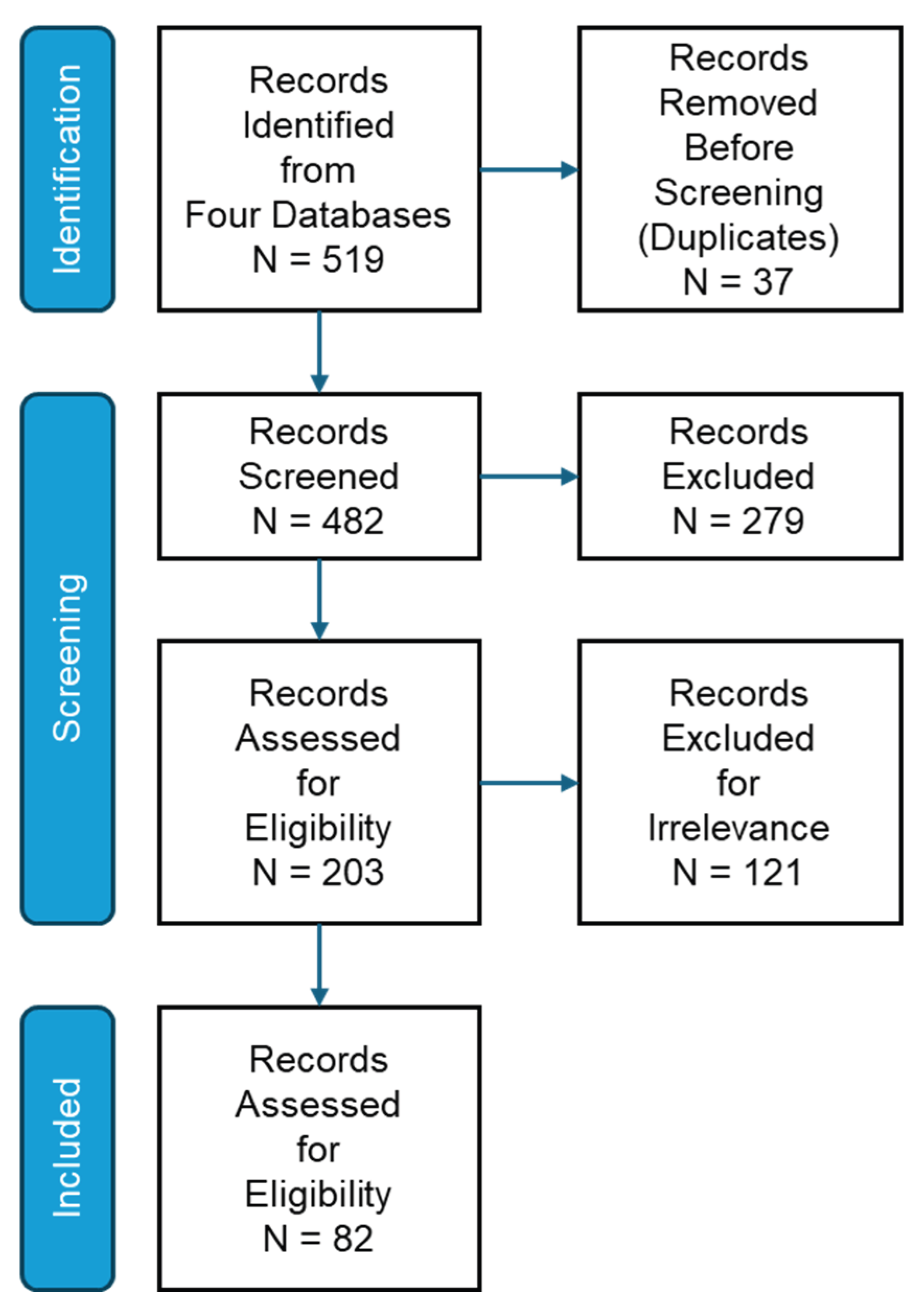
Figure 2.
Term co-occurrence and thematic clustering.
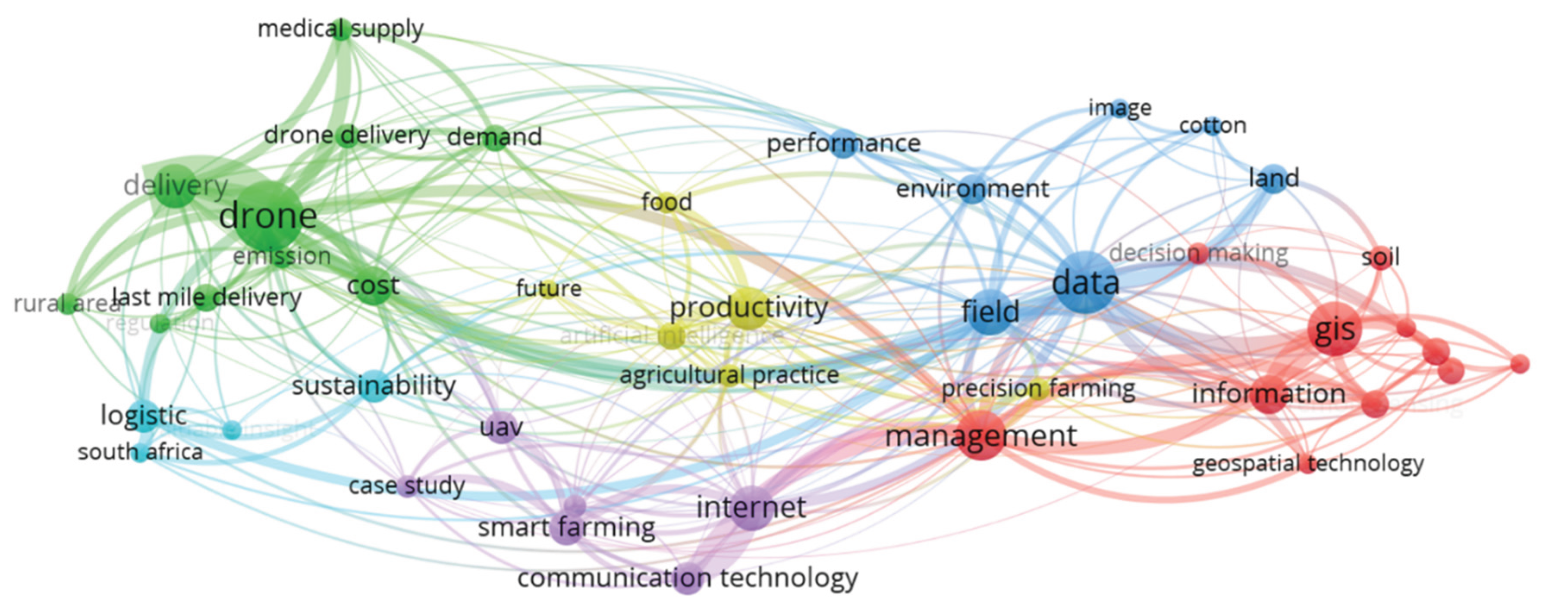

Table 1.
Quality appraisal protocol to guide article selection.
| Assessment Criteria | Quality Evaluation |
|---|---|
| GIS Integration in Agricultural Systems | Specifically integrated GIS for agricultural applications, route optimization, or spatial decision-making. |
| Hybrid Truck-Drone Technology | Addressed hybrid delivery systems that combine truck and drone technologies for logistics. |
| Last-Mile Delivery in Agricultural | Explicitly examined delivery challenges and solutions in last-mile deliveries with an agricultural context. |
| Route Optimization and Spatial Analysis | Investigated spatial optimization algorithms, delivery routing, or site selection methodologies. |
| Empirical Data and Quantitative Methods | Utilized robust datasets, statistical analysis, or quantitative research methodologies. |
| Rural Infrastructure Considerations | Addressed challenges specific to rural environments, including terrain, weather, and accessibility factors. |
| Sustainability and Efficiency Metrics | Evaluated environmental impact, energy efficiency, or cost-effectiveness of delivery systems. |
| Technological Integration and IoT | Incorporated smart agriculture technologies, IoT sensors, or real-time monitoring systems. |
Table 2.
Thematic classification of the studies.
| Classification | Description |
|---|---|
| GIS Applications and Spatial Analytics | Focused on geospatial modeling, spatial data analysis, land use classification, remote sensing integration, and GIS-based route optimization for agricultural logistics. |
| Truck-Drone Hybrid System Coordination | Examined vehicle coordination algorithms, launch-and-recovery models, payload optimization, route planning heuristics, and operational efficiency of hybrid delivery systems |
| Smart Agriculture Technology Integration | Addressed IoT-enabled sensor networks, edge computing, autonomous farm monitoring systems, precision agriculture applications, and data-driven decision making. |
| Rural Infrastructure and Implementation | Focused on infrastructure limitations, last-mile accessibility challenges in rural areas, regulatory compliance, and deployment strategies for remote agricultural regions |
| Sustainability and Economic Impact Assessment | Evaluatesd carbon emissions reduction, energy efficiency optimization, cost-benefit analysis, and environmental externalities of drone-assisted agricultural delivery systems |
Table 3.
Literature Categorization.
| Topic | Articles |
|---|---|
| GIS for Agricultural Logistics | [5] [6] [12] [13] [14] [15] [16] [17] [18] [19] [20] [21] [22] [23] [24] [25] [26] [27] [28] [29] [30]. |
| Smart Agriculture and Data Systems | [2] [7] [8] [31] [32] [33] [34] [35] [36] [37] [38] [39] [40] [41] [42] [43] [44] [45] [46] [47] [48] [49] [50] [51] [52] [53] [54] [55]. |
| Truck–Drone Hybrid Performance | [1] [51] [56] [57] [58] [59] [60] [61] [62] [63] [64] [65] [66] [67] [68]. |
| Rural/Cold-Weather Contexts | [1] [56] [69] [63] [64] [65] [67] [70] [71] [72] [73] [74] [75] [76]. |
| Environmental/Economic Outcomes | [59] [69] [70] [72] [73]. |
| Operational Enablers and Design Choices | [57] [60] [63] [64] [65] [67] [74] [77]. |
| Security, Privacy, and Trust | [9] [43] [46] [47] [48] [49] [50] [78] [79] [80] [81] [82] [83] [84]. |
Disclaimer/Publisher’s Note: The statements, opinions and data contained in all publications are solely those of the individual author(s) and contributor(s) and not of MDPI and/or the editor(s). MDPI and/or the editor(s) disclaim responsibility for any injury to people or property resulting from any ideas, methods, instructions or products referred to in the content. |
© 2025 by the authors. Licensee MDPI, Basel, Switzerland. This article is an open access article distributed under the terms and conditions of the Creative Commons Attribution (CC BY) license (http://creativecommons.org/licenses/by/4.0/).
Copyright: This open access article is published under a Creative Commons CC BY 4.0 license, which permit the free download, distribution, and reuse, provided that the author and preprint are cited in any reuse.


