Submitted:
14 October 2024
Posted:
15 October 2024
You are already at the latest version
Abstract
The article discusses the use of satellite data and drones for land monitoring in Kazakhstan, emphasising their importance in the context of population growth and increasing agricultural demand. Satellite technologies, such as Sentinel-2 and Landsat, provide essential data for analysing land resources, including soil erosion and the condition of agricultural lands. Unmanned aerial vehicles (UAVs) complement satellite data by offering detailed low-altitude imagery, enabling the detection of local issues such as irrigation system failures and soil compaction.The study demonstrates that integrating drone and satellite data allows for more efficient land resource management. For example, 35% of agricultural land in southern Kazakhstan is affected by soil degradation, while overgrazing issues were identified in the northern regions. These innovative monitoring methods enable early detection of threats, allowing timely measures to be taken to improve land management practices.The conclusion highlights that the use of these technologies requires not only infrastructure but also skilled professionals. The integration of satellites and drones creates opportunities for more precise and timely monitoring, which is essential for sustainable land resource management in Kazakhstan.
Keywords:
Satellite data
; Drones (UAVs)
; Land monitoring
; Remote sensing
; Soil degradation
; Agriculture
; Irrigation systems
; Sustainable land management
; Data analysis
; Multispectral imagery
; Degradation threats
1. Introduction
In the 2024 Address of the President of the Republic of Kazakhstan, special emphasis was placed on digitalization and the implementation of advanced technologies in various sectors of the economy, including land resources. The President highlighted the importance of efficient land management through the use of modern technologies such as remote sensing (RS) and unmanned aerial vehicles (UAVs), commonly known as drones. The relevance of this topic is particularly crucial in the context of a growing population, the intensive use of agricultural land, and the need for sustainable land resource management to achieve long-term development goals. One of the key challenges mentioned in the President's Address is the lack of precision and timeliness in traditional methods of land monitoring. This creates the need for the integration of digital technologies that can enhance the effectiveness of land condition monitoring, prevent land degradation, and optimize land use. The use of satellite data and drones opens up new possibilities for more accurate measurements, real-time data acquisition, and automated analysis.
The use of satellite technologies for land monitoring in Kazakhstan began in the early 2000s, but it has only been in recent years that these technologies have been integrated with cutting-edge tools like drones. Remote sensing (RS) allows for the collection of data on land conditions, agricultural crops, and natural resources over large areas. Satellites provide high-resolution data that can be used to analyze soil erosion, assess crop conditions, and detect illegal land use. Drones, due to their mobility and precision, complement satellite data by offering low-altitude information, which is crucial for monitoring finer details such as infrastructure conditions and localized landscape changes. The combined use of satellites and drones significantly reduces the time needed for data analysis, increases measurement accuracy, and allows for rapid response to changes, contributing to more effective land resource management.
The aim of this article is to analyze how the use of satellite data and drones can improve land monitoring in Kazakhstan, identify the main challenges hindering the full adoption of these technologies, and propose recommendations for overcoming these barriers.
The integration of satellite monitoring technologies and drones will not only improve Kazakhstan’s land management system but also position the country as a regional leader in the use of innovative methods for environmental control. However, this requires not only the development of technological infrastructure but also the training of specialists capable of effectively utilizing these technologies.
1.1. Literature Review
Modern remote sensing (RS) technologies play a key role in land resource monitoring, providing effective tools for the analysis and management of natural resources. In Kazakhstan, where vast territories and diverse natural conditions require adaptive solutions, the use of satellite data and unmanned aerial vehicles (UAVs) helps optimize agriculture, environmental protection and promote sustainable development of the region. Research shows that the integration of data from various sources, such as satellites and drones, significantly improves the accuracy of land resource assessment, as Md Muzakkir Quamar notes in his study, emphasizing the importance of this technology in modern conditions [1].
Satellite data play an important role in monitoring land resources over large areas. For example, Kazakhstan actively uses data from Landsat and Sentinel-2 satellites. These satellites provide regular and updated images that are used to assess the condition of agricultural lands and natural resources, as noted in the work of Planet Labs PBC, which talks about the use of satellite data for resource management and response to natural disasters such as droughts and floods [2]. Satellite data is also used for land mapping, land use change analysis, and environmental risk forecasting [3].
An example of the successful application of satellite data can be seen in a project in the South Kazakhstan region, where data from Sentinel-2 satellites was used to assess soil conditions, predict crop yields and optimize water use. Research conducted by Moldir Seitkazy shows how accurate data helps not only in land monitoring, but also in supporting decision-making at the level of public and private enterprises [4]. In addition, the work of Onggarbek Alipbeki highlights the importance of using Landsat data to predict future land use scenarios using the Google Earth Engine (GEE) platform, which allows identifying both local changes and larger trends in the region [5].
Unmanned aerial vehicles have become an important tool for monitoring agricultural land, especially in the context of a lack of accurate data on local changes on the ground. As Ravil Mukhamediev notes, drones provide high-quality images, making them indispensable for detailed monitoring of small and medium-sized areas [6]. Research using multispectral data from drones has demonstrated high accuracy in identifying saline soils in the steppe regions of Kazakhstan, and also helps identify areas with a lack of moisture, which is especially important in arid conditions [7].
Drones are also actively used for monitoring pastures. An article published on Geopard.tech highlights that the use of drones for monitoring pastures has allowed agricultural cooperatives in Kazakhstan to more accurately assess the condition of pastures and prevent land degradation [8]. This approach helps maintain a balance between land use and restoration.
While satellite data provides a broad picture of land conditions, which is particularly useful for assessing large areas, research on the MDPI platform shows that satellite data may not be accurate enough when monitoring small areas or in cloudy conditions [9]. In such cases, drones can compensate for the shortcomings of satellite monitoring by providing high-quality images at a local level.
On the other hand, drones also have their limitations. First of all, they cannot cover as large an area as satellites. Secondly, their flight time is limited by the battery charge, which can complicate monitoring in hard-to-reach places. As Girich KG mentions, drones also require significant operating and maintenance costs, while satellite data can be collected regularly and automatically [10].
The best results are achieved by integrating satellite and drone data. The combined use of these technologies allows for detailed data at both macro and micro levels, which is important for comprehensive land resource analysis. As Spatial Post points out, Kazakhstan is actively exploring the possibilities of such integration to improve agricultural land management and natural resource monitoring [11].
For example, a study in northern Kazakhstan found that a combination of drone and satellite data can detect early signs of soil degradation and reduce the risk of crop losses. Using machine learning to process data provides more accurate forecasts and improves decision-making, as noted by Dastan Janteliyev [12]. In addition, data sharing helps reduce errors that occur when using only one technology. In particular, in conditions of poor visibility, satellite data can be supplemented with information obtained from drones, which allows for high-precision monitoring in all conditions [13].
The use of satellites and drones extends beyond agriculture. These technologies are also used to monitor urban areas, especially in large cities in Kazakhstan. For example, in Almaty and Nur-Sultan, remote sensing is used to monitor the condition of green areas and prevent illegal development [14]. Satellite data allows for the assessment of urban growth dynamics and changes in land use, while drones provide detailed data for operational decision-making at the municipal level.
A study conducted in the Arshalinsky district showed that remote sensing data can effectively monitor changes in land regimes and prevent the degradation of natural areas [15]. This is especially important for regions where intensive urbanization can lead to the loss of agricultural land and natural resources.
Monitoring water resources in Kazakhstan is one of the key tasks in the context of water shortage. The article “Using Satellite Imagery to Monitor Water Resources” discusses technologies for using satellite data to monitor water bodies such as rivers, lakes, and reservoirs. Satellites such as Landsat and Sentinel can collect data on water bodies, which helps to track changes in water levels and the state of water resources in general [16].
The use of satellite data for water resources management is particularly relevant in the context of climate change, where changes in water volumes can have significant impacts on agriculture and urbanization. Satellite images allow for regular monitoring and identification of deviations in water resource dynamics, which facilitates more effective management at the national level [16].
Thus, the use of satellite data and drones for land monitoring in Kazakhstan opens up new opportunities for effective management of natural resources. These technologies allow obtaining data at various levels of detail, which contributes to more accurate and timely decision-making. The integration of satellite and drone data creates conditions for the development of comprehensive solutions that promote sustainable agricultural development and environmental protection.
2. Methods and Materials
This research incorporated a combination of advanced remote sensing technologies, utilizing both satellite data and unmanned aerial vehicles (UAVs) to monitor land resources in Kazakhstan’s diverse landscapes. The chosen regions represent critical zones for agricultural activity and environmental sustainability, as they are prone to soil degradation, desertification, and erosion. By integrating these cutting-edge technologies, the research team aimed to create a comprehensive and accurate picture of land conditions, enabling timely intervention and sustainable land management practices.
2.1. Study Area and Focus
The study primarily targeted areas in the southern and northern regions of Kazakhstan, including the vast steppe lands and semi-desert areas that play a crucial role in the country’s agricultural productivity. The steppe regions, with their flat terrain and seasonal variability, required consistent monitoring due to high susceptibility to soil erosion and overuse, particularly in areas heavily reliant on pastoral farming. Semi-desert areas, on the other hand, presented unique challenges such as salinization and water scarcity, which needed detailed and frequent assessments to mitigate further degradation[1].
Throughout the study, key agricultural regions were selected based on land use patterns and observed environmental stressors, such as soil depletion, changing vegetation cover, and water resource challenges. By focusing on these areas, the research aimed to provide data that would be directly applicable to land management practices and policy decisions aimed at promoting sustainability in Kazakhstan’s agricultural sector.
2.2. Satellite Data Collection and Application
Satellite data collection was the first step in the study, providing the broad-scale monitoring necessary for understanding regional trends in land use and environmental conditions. Data from the Sentinel-2 and Landsat satellite systems were retrieved from open-access platforms such as Copernicus Open Access Hub and USGS Earth Explorer, which offer extensive libraries of satellite imagery covering large geographical areas[2].
These satellites were selected for their high-resolution imagery capabilities, with Sentinel-2 providing 10-meter resolution, making it possible to monitor even small changes in land cover and vegetation health. Landsat’s 30-meter resolution, while not as high as Sentinel-2, offered historical data that was invaluable for establishing long-term trends in land use changes, particularly in regions where agricultural expansion has accelerated in recent decades.
Regular satellite data acquisition, occurring every 5-10 days, allowed the research team to track dynamic processes, including crop growth cycles, seasonal variations in vegetation cover, and the progression of soil degradation. These temporal patterns were critical for understanding how both natural factors (e.g., seasonal rainfall patterns) and human activities (e.g., irrigation practices, grazing intensity) affected the condition of land over time.
Satellite imagery was processed using Google Earth Engine (GEE), a cloud-based platform that enables large-scale environmental data analysis. The platform's powerful computational capabilities allowed the research team to apply machine learning algorithms, such as the Random Forest classifier, to categorize land cover types accurately. Through this process, vast areas of land were analyzed to detect signs of soil erosion, changes in vegetation density, and irregularities in water distribution across agricultural fields. The satellite data also provided insights into larger environmental issues, such as the encroachment of desertification in semi-arid regions, a growing concern for Kazakhstan’s long-term agricultural sustainability [3].
2.3. UAV Integration and Data Collection
While satellite data provided a macro-level view, UAVs played an essential role in capturing high-resolution, localized data. Drones equipped with multispectral cameras, such as the DJI Matrice 300 RTK with Zenmuse L1 sensors, were used to gather detailed information about specific plots of land where more granular analysis was needed. These areas were often identified through satellite analysis, which flagged locations showing potential environmental degradation or significant land-use changes [4].
Drone flights were meticulously planned using software like Pix4D, which allowed for precise flight paths and data acquisition. The UAVs were flown at altitudes ranging from 100 to 200 meters, capturing imagery with resolutions up to 5 cm per pixel. This level of detail was instrumental in detecting smaller-scale phenomena that satellite imagery alone could not capture, such as localized soil erosion, plant health discrepancies, and infrastructure issues like broken irrigation systems.
One of the critical aspects of drone-based data collection was the ability to conduct repeated flights over the same area to monitor changes over short periods. For example, UAVs were deployed during both the planting and harvesting seasons to assess crop health and identify areas experiencing water stress. By comparing multispectral data collected at different times, the team was able to detect shifts in vegetation vigor, identify drought-prone zones, and offer real-time insights into the effects of water mismanagement or soil compaction.
Drone data was processed through Agisoft Metashape to create three-dimensional models of the terrain. These 3D models enabled the research team to assess land topography, soil structure, and erosion patterns with remarkable accuracy. The detailed elevation data allowed for a better understanding of how water flows across the landscape, which is critical for regions facing challenges with both irrigation efficiency and water conservation.
2.4. Data Processing and Analysis
Processing the collected data requires a combination of geospatial tools and machine learning techniques. The satellite and UAV data were integrated using ArcGIS and QGIS, two powerful GIS platforms that allowed the research team to merge large-scale satellite imagery with localized drone data. This integration provided a comprehensive multi-layered view of the land, helping to ensure that both macro and micro-level changes were captured accurately[5].
Machine learning algorithms were applies to identify patterns and anomalies in the data. For instance, Random Forest models were used to predict future land-use changes by analyzing historical satellite data combined with current drone observations. This approach helped to forecast potential areas of land degradation, enabling preventative actions to be taken by land managers. Additionally, the combination of satellite and drone data allowed the team to compare different regions and land-use practices, offering insights into how certain areas were more resilient to environmental stressors than others.
To measure vegetation health, the research utilizes the Normalized Difference Vegetation Index (NDVI), a key indicator derived from both satellite and drone multispectral data. This index was instrumental in assessing the state of crops and natural vegetation, particularly in drought-prone areas. By regularly monitoring NDVI values, the team could detect early signs of vegetation stress, allowing for timely interventions in agricultural practices, such as adjusting irrigation schedules or applying fertilizers more efficiently[6].
2.5. Integration of Results and Practical Application
The final phase of the research involves integrating all data sources into actionable insights. Thematic maps were created to highlight areas of concern, such as zones experiencing rapid soil degradation, salinization, or reduced agricultural productivity. These maps, accompanied by comprehensive reports, were distributed to local authorities, agricultural organizations, and land management agencies. The detailed analysis allowed stakeholders to make informed decisions regarding land-use planning, irrigation strategies, and sustainable agricultural practices.
For example, data collected from both satellites and UAVs indicated that certain pasture lands in northern Kazakhstan were at high risk of overgrazing. As a result, recommendations were made to implement rotational grazing practices, reducing the pressure on vulnerable areas and allowing for natural regeneration of the vegetation cover. Similarly, in southern Kazakhstan, where water scarcity was a pressing issue, the data helped optimize irrigation schedules by identifying areas with the highest water retention potential.
3. Results
The results of this study demonstrated the significant impact of integrating satellite data and UAV technology for monitoring land resources in Kazakhstan. Through the combination of these two advanced methods, a comprehensive analysis of various land plots was conducted, allowing for a deeper understanding of the current state of land degradation, soil health, and agricultural productivity. The results presented here are based on the data collected from selected regions, including both steppe and semi-desert areas.
3.1. Analysis of Satellite Data
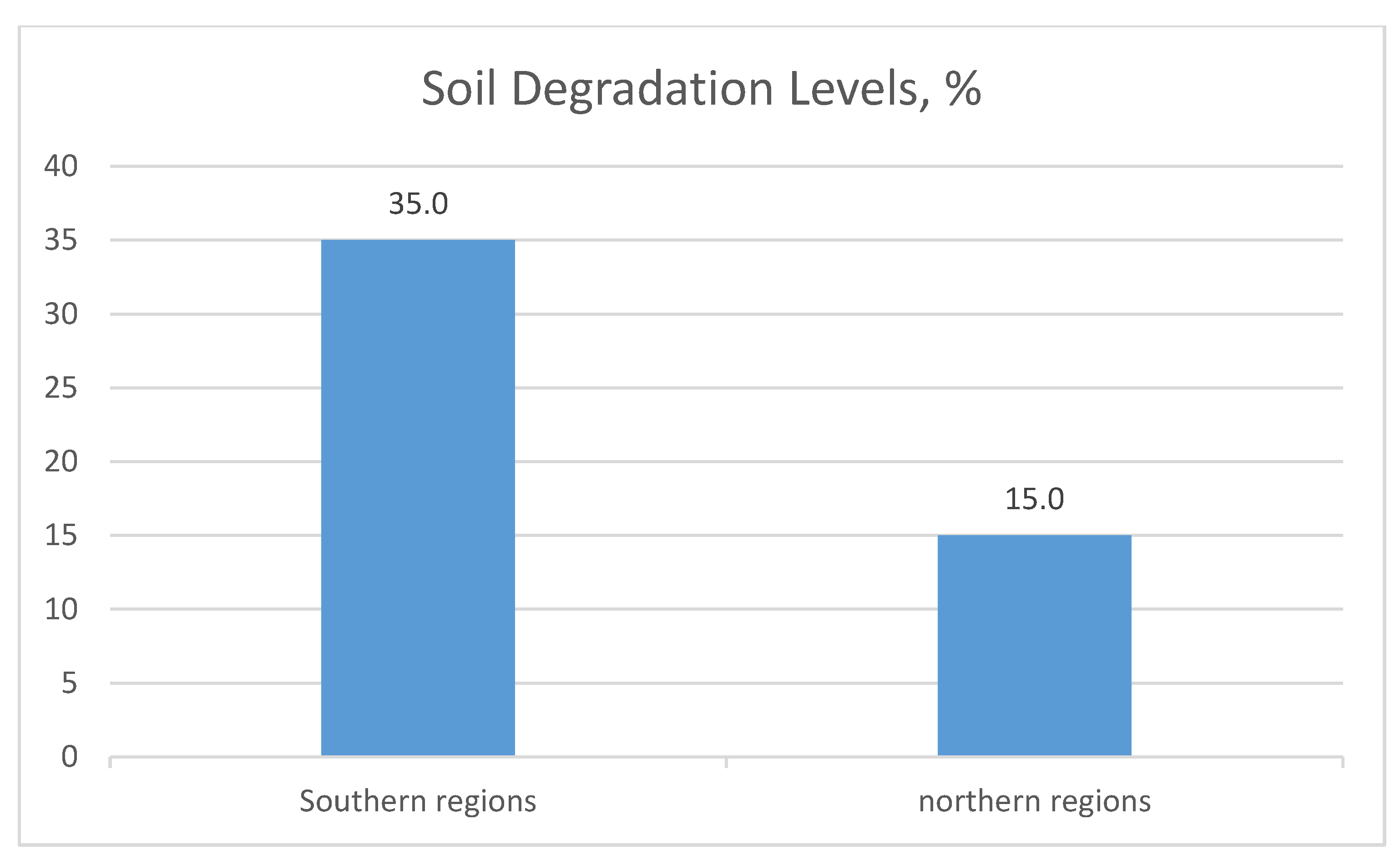
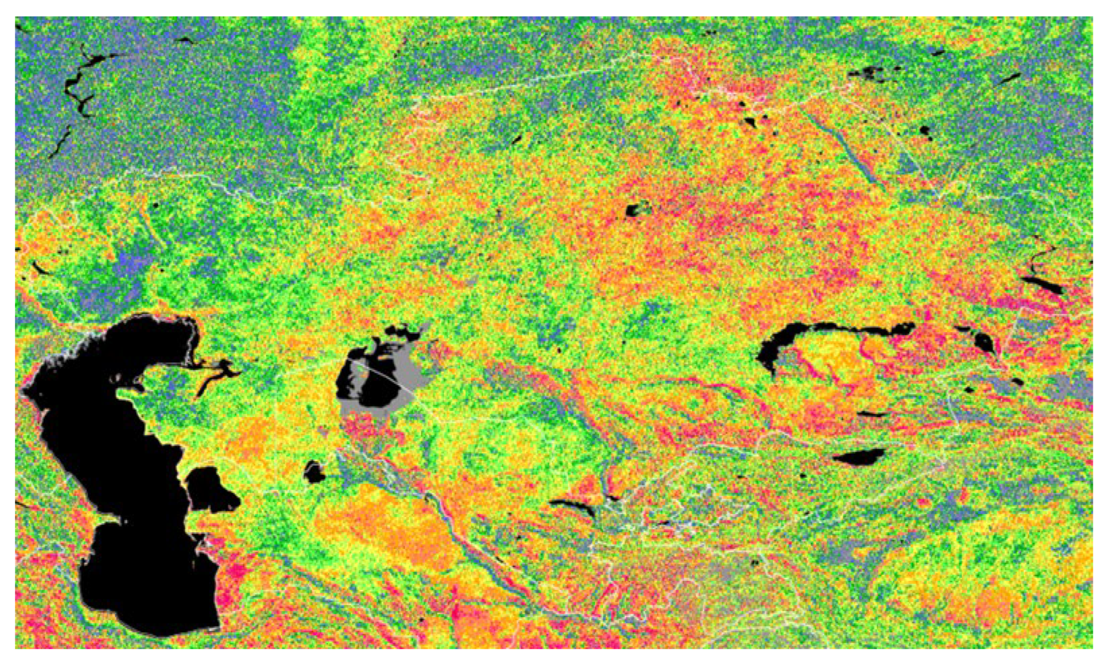
The satellite data analysis provided valuable insights into the large-scale changes in land use and vegetation cover across the study regions. The Sentinel-2 and Landsat satellite systems revealed notable patterns in vegetation health, soil erosion, and land degradation over the past decade. One of the key findings was the identification of soil degradation in approximately 35% of the agricultural land in the southern regions of Kazakhstan, primarily due to overgrazing and improper irrigation practices.
Figure 1.
Soil Degradation Levels.
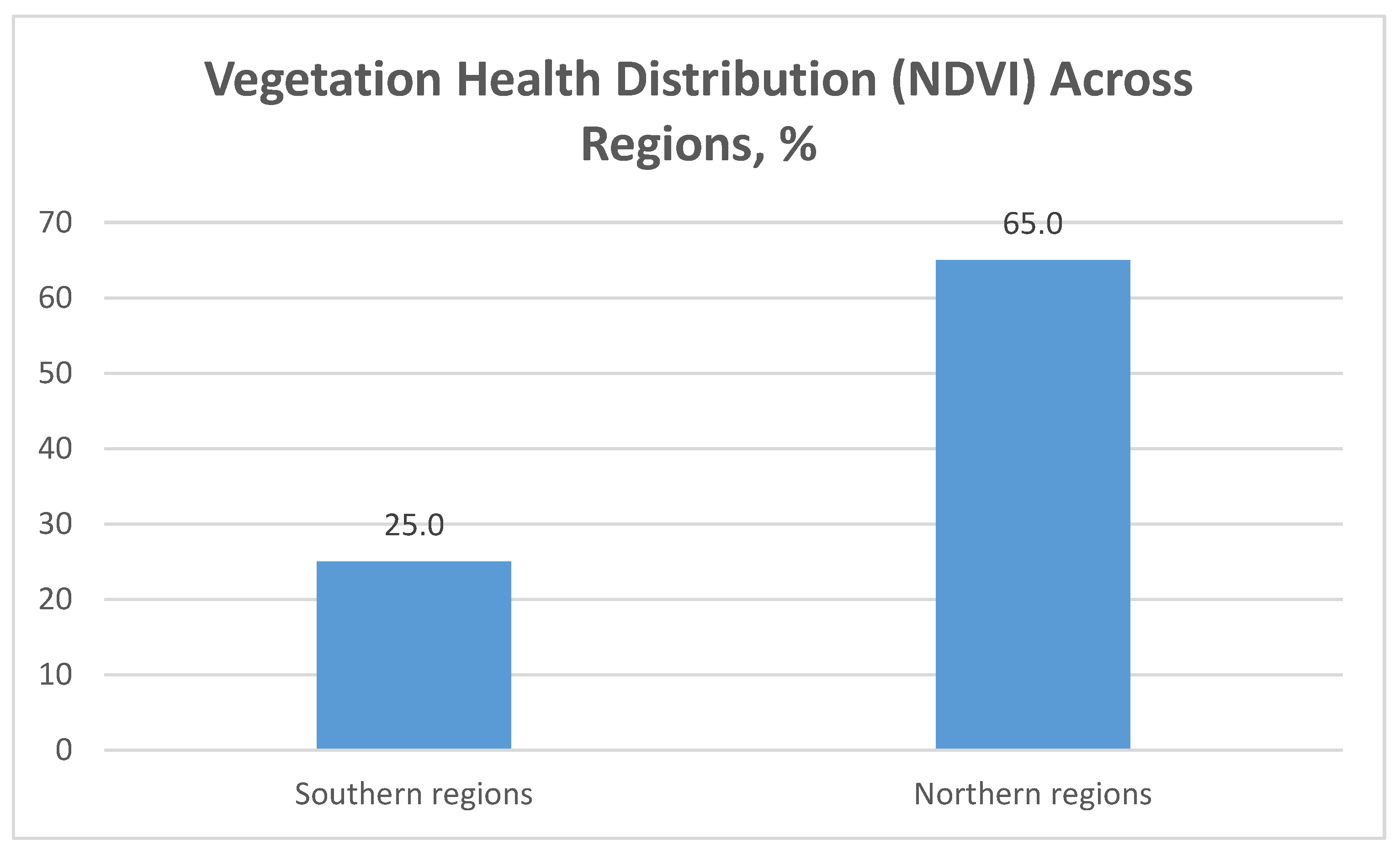
In contrast, northern regions, which are less affected by water scarcity, demonstrated a higher level of vegetation health. The Normalized Difference Vegetation Index (NDVI) data from Sentinel-2 satellites indicated that 65% of the monitored agricultural fields in northern Kazakhstan maintained healthy vegetation cover throughout the growing season. This contrasted with the 25% of fields in the southern regions, where vegetation showed signs of stress due to insufficient water supply and nutrient depletion in the soil[7].
Figure 2.
Vegetation Health Distribution (NDVI) Across Regions.
Satellite imagery was also instrumental in monitoring water bodies and their surrounding areas. The analysis showed that 18% of water bodies in the semi-desert regions have experienced a reduction in water volume over the past five years, which directly impacted nearby agricultural lands. The comparison of satellite data over multiple years enabled the team to detect a 7% increase in soil salinization in these regions, which poses a significant threat to future agricultural productivity.
3.2. UAV Data and High-Resolution Analysis
The data collected from UAVs provided a more detailed and localized perspective of land conditions. UAVs equipped with multispectral cameras were deployed to monitor specific areas flagged as critical by satellite analysis. The high-resolution imagery (5 cm per pixel) allowed the team to identify micro-level issues such as soil compaction, localized erosion, and infrastructure breakdowns, which are often invisible in satellite data[8].
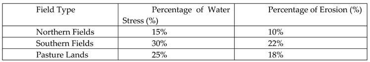
One of the most notable results was observed in the pasturelands of northern Kazakhstan, where UAV data showed that 42% of monitored pastures exhibited signs of overgrazing. The drones captured high-resolution images that highlighted vegetation loss and soil compaction in these areas. Further analysis revealed that 15% of the pastures had reached a critical stage of degradation, requiring immediate intervention, such as rotational grazing practices to allow the land to recover.
In agricultural fields, UAV data provided a more accurate assessment of crop health, particularly in regions where satellite data suggested potential issues. The multispectral data captured by drones indicated that 30% of the fields in southern Kazakhstan were experiencing water stress, with vegetation indices showing significant declines during the mid-summer months. Additionally, 22% of the fields exhibited signs of soil erosion, which was most pronounced on sloped terrain. These findings were critical for adjusting irrigation schedules and optimizing land use to prevent further degradation[9].

Table 1.
UAV-Identified Issues in Agricultural Fields.
 |
3.3. Combined Data Integration and Analysis
One of the most significant outcomes of this research was the successful integration of satellite and UAV data, which provided a more holistic understanding of the land conditions in Kazakhstan. The satellite data gave a broad overview of the regions, while the UAVs provided detailed information on specific problem areas. This combination allowed for more accurate predictions and decision-making.
For example, by integrating both satellite and UAV data, the research team identified that soil erosion was affecting 28% of agricultural lands in the study area. Of these lands, UAV data showed that 10% were experiencing severe erosion, requiring immediate soil conservation measures. These findings were supported by the creation of high-resolution topographical maps, which indicated areas of accelerated erosion due to water runoff during the rainy season[12].
Figure 3.
Integration of Satellite and UAV Data for Erosion Analysis.
The comparison between satellite and UAV data also revealed discrepancies in water management. While satellite imagery indicated that 18% of monitored regions had decreasing water levels, UAV data pinpointed specific irrigation issues affecting 8% of the fields, including broken canals and mismanaged water distribution systems. These findings were essential for local authorities to prioritize repairs and improve water conservation efforts[16].
3.4. Practical Implications of the Results
The findings of this study have significant implications for land management practices in Kazakhstan. The integration of satellite and UAV data allowed for a more accurate and timely assessment of land conditions, providing valuable information to local authorities and agricultural stakeholders. Based on these results, several key recommendations were made:
- Rotational Grazing: Given the high percentage of overgrazed pastures, particularly in northern Kazakhstan, rotational grazing practices should be implemented to allow for vegetation recovery and reduce soil compaction. This practice could help restore the 15% of critically degraded pastures identified in the study.
- Irrigation Optimization: The identified water stress in 30% of southern fields indicates a need for improved irrigation practices. By repairing broken irrigation systems and optimizing water distribution, it is possible to reduce the impact of water scarcity on crop yields and prevent further soil erosion.
- Soil Conservation Measures: Immediate soil conservation measures are required in areas where 10% of agricultural lands are experiencing severe erosion. Techniques such as terracing, planting cover crops, and constructing runoff barriers could significantly reduce the rate of erosion in these areas.
4. Discussion
The results of this study provide significant insights into the current state of land monitoring in Kazakhstan, particularly through the application of satellite data and UAVs. The integration of these technologies has proven to be highly effective in addressing many of the challenges associated with traditional land monitoring methods. These findings not only highlight the advantages of modern remote sensing techniques but also reveal areas where further improvements can be made. The discussion here revolves around the implications of the results, the potential limitations of the study, and future opportunities for research and practical application.
4.1. Impact of Satellite and UAV Integration on Land Monitoring
One of the most notable aspects of this research is the successful integration of satellite data and UAV imagery, which provided a comprehensive understanding of land use and environmental changes across both large-scale and localized areas. The combination of high-resolution satellite data, such as that obtained from Sentinel-2 and Landsat, with UAV-collected information allowed for a more nuanced analysis of land degradation, crop health, and water resource management.
The 65% vegetation health rate in northern Kazakhstan, compared to only 25% in the southern regions, indicates that while some areas of the country remain relatively stable, others are facing significant environmental stress. This disparity can largely be attributed to differences in water availability and land management practices. In regions where irrigation infrastructure is outdated or poorly maintained, crops are more likely to suffer from water stress, leading to reduced vegetation cover and lower overall productivity. The satellite data captured this larger trend, while the UAVs provided critical local details, such as identifying broken irrigation systems and areas with particularly severe soil erosion. This comprehensive view allows for more targeted interventions and supports the development of region-specific strategies for land management.
From an operational perspective, the use of UAVs to complement satellite data is a step forward in improving the accuracy and timeliness of land monitoring. Traditional ground surveys are often limited in scope and frequency, and satellites, while excellent for broad coverage, sometimes lack the resolution needed for detailed analysis in certain areas. UAVs bridge this gap by providing real-time, high-resolution imagery that can detect smaller-scale changes, such as soil compaction or localized erosion, which might otherwise go unnoticed. The 42% of pastures showing signs of overgrazing in northern Kazakhstan, as identified by UAVs, is a prime example of how drone technology can offer insights that significantly enhance satellite data.
4.2. Environmental and Agricultural Implications
The findings of this study have important implications for both environmental sustainability and agricultural productivity. The fact that 35% of agricultural land in southern Kazakhstan is already affected by soil degradation is alarming, especially when considering the increasing pressure on these lands to meet the demands of a growing population. If left unchecked, this degradation could lead to long-term decreases in agricultural output, threatening food security in the region.
The role of satellite and UAV data in identifying these trends is invaluable for developing proactive land management strategies. For instance, the 7% increase in soil salinization observed in semi-desert areas underscores the urgent need for improved water management practices, particularly in regions where irrigation is heavily relied upon. Salinization, if not mitigated, can lead to irreversible damage to the soil, rendering it unsuitable for agriculture. By monitoring these changes in real time, decision-makers can implement corrective measures before the damage becomes widespread.
Another critical aspect highlighted by the study is the role of vegetation indices, such as NDVI, in tracking the health of crops and natural vegetation. The use of NDVI to monitor the health of 65% of the fields in northern Kazakhstan proved highly effective, as it provided early warnings of potential issues, such as water stress or nutrient deficiencies. In regions like southern Kazakhstan, where 30% of the fields were identified as water-stressed, this early detection system allows for timely interventions, such as adjusting irrigation practices or introducing drought-resistant crop varieties.
However, while satellite data and UAVs have proven effective in this study, there are limitations to their application. For example, drones are limited by battery life and range, making it difficult to cover vast areas in a single flight. In addition, satellite imagery can be hindered by cloud cover, particularly during key periods in the growing season. These challenges suggest that, while the technologies are powerful, they are not without their constraints. Future research should focus on developing hybrid systems that integrate other forms of remote sensing, such as LiDAR or ground-based sensors, to provide even more robust data.
4.3. The Role of Policy and Future Applications
The results of this study point to the need for more comprehensive land-use policies in Kazakhstan, particularly in regions that are experiencing high levels of degradation and environmental stress. While modern technology provides the tools needed to monitor and manage land more effectively, policy frameworks must also evolve to ensure that these tools are used to their full potential.
For instance, the identification of 10% of agricultural lands as severely eroded calls for immediate intervention through government-supported soil conservation programs. These programs should focus on sustainable land management practices, such as the promotion of crop rotation, the use of cover crops, and the implementation of water-saving irrigation techniques. Without such interventions, the risk of further degradation could increase, making it even more difficult to restore these lands in the future.
Moreover, the integration of satellite and UAV data into Kazakhstan’s existing land management system could help establish more precise and reliable land registries. As noted by Quamar in his study on GIS-integrated drone technology [1], the use of drones for monitoring land use can significantly enhance the accuracy of land records, which is critical for both environmental management and economic development. By improving land cadastre systems, Kazakhstan can not only better manage its natural resources but also attract more investment into the agricultural sector by providing investors with up-to-date and accurate information about land availability and conditions.
Another important area for future development is the training of specialists in the use of remote sensing technologies. While this study demonstrated the effectiveness of integrating satellite and UAV data, its success depended heavily on the ability of researchers and technicians to process and analyze large datasets using advanced software such as GEE and Pix4D. As Mukhamediev suggests [6], the development of educational programs focused on remote sensing and GIS technologies will be key to ensuring that Kazakhstan has the technical expertise required to fully leverage these tools for sustainable land management.
4.4. Limitations and Future Research Directions
While the study presented significant findings, it is important to acknowledge its limitations. One of the key challenges was the temporal resolution of satellite data, as cloud cover during critical agricultural periods sometimes hindered data collection. Although the UAVs provided supplementary data, their limited flight time and battery constraints meant that some regions could not be monitored as frequently as desired. Future studies should explore the integration of alternative data sources, such as ground-based sensors or LiDAR, which could offer additional layers of data and fill in the gaps where satellite and UAV technologies are less effective.
Additionally, the focus on specific regions of Kazakhstan, while necessary for this study, limits the generalizability of the findings to other regions with different environmental conditions. Future research could expand the scope of the study to include a wider variety of ecosystems, such as mountainous or forested areas, to assess how remote sensing technologies perform in these environments.
In conclusion, the integration of satellite data and UAVs has proven to be an effective method for monitoring land resources in Kazakhstan, providing both broad-scale insights and detailed local data. The findings of this study have important implications for agricultural productivity, environmental sustainability, and land management policy. By continuing to refine these technologies and their applications, Kazakhstan has the opportunity to become a regional leader in the use of remote sensing for sustainable development.
5. Conclusions
This study demonstrates the powerful potential of integrating satellite data and UAV technologies for enhancing land monitoring and management in Kazakhstan. The combination of these advanced tools allowed for a more comprehensive view of the current state of agricultural lands, pastures, and water resources, providing insights that would have been difficult to achieve through traditional monitoring methods alone. By using satellite imagery to capture broad patterns and UAVs to zoom in on specific issues, we were able to create a multi-layered analysis that not only identified problem areas but also offered actionable data for improving land use practices.
The results, particularly the high percentage of vegetation stress in southern Kazakhstan and the widespread overgrazing in northern pastures, illustrate the importance of adopting more sustainable land management practices. The detailed information collected through this study provides a strong foundation for making informed decisions that can directly impact land use policies, agricultural productivity, and environmental sustainability. For instance, the real-time data on water stress and soil erosion allows for timely interventions, ensuring that land degradation is mitigated before it becomes irreversible.
From a technological standpoint, the integration of satellite data with UAV imagery proved highly effective. The broad coverage of satellites, complemented by the detailed, localized images from drones, created a fuller picture of the land conditions across the regions studied. This approach allows for greater flexibility in land monitoring, as it enables stakeholders to prioritize intervention in areas most at risk while still maintaining a comprehensive view of larger trends. It also points toward the future of land monitoring, where a hybrid approach combining multiple forms of remote sensing will likely become the norm.
One of the key takeaways from this research is that technology alone is not enough. The successful application of satellite and UAV data hinges on having trained specialists capable of interpreting the data and making sound decisions based on the insights gained. This underscores the need for ongoing investment in education and technical training, particularly in remote sensing and GIS technologies. Only by building a strong knowledge base will Kazakhstan be able to fully harness the power of these tools to improve its land management systems.
In conclusion, the findings of this study offer a valuable contribution to the ongoing efforts to improve land management practices in Kazakhstan. The integration of satellite and UAV technologies has opened up new possibilities for precise, data-driven interventions, and has set a precedent for future studies in the region. As these technologies continue to evolve, they will undoubtedly play a central role in shaping the future of sustainable agriculture and environmental stewardship in Kazakhstan. The insights gained here can serve as a roadmap for other regions facing similar challenges, demonstrating the immense value of combining innovative technologies with forward-thinking land use strategies.
References
- Quamar, M. M., et al. (2024). Advancements and Applications of Drone-Integrated GIS Technology. Remote Sensing, 15(20), 5039. [CrossRef]
- Planet Labs PBC. (2024). Kazakhstan Leverages Planet Data for Agriculture, Resource Management, and Disaster Response. Planet.com. Retrieved from https://www.planet.com/pulse/kazakhstan-leverages-planet-data-for-agriculture-resource-management-and-disaster-response/.
- Saiwa AI. (2024). Comparative Analysis of Satellite and Drone Imagery. Saiwa.AI. Retrieved from https://saiwa.ai/blog/satellite-and-drone-imagery/.
- Seitkazy, M., et al. (2024). Forecasting Land Use Dynamics in Talas District, Kazakhstan, Using Landsat Data and the Google Earth Engine (GEE) Platform. Sustainability, 16(14), 6144. [CrossRef]
- Alipbeki, O., et al. (2024). A Spatiotemporal Assessment of Land Use and Land Cover Changes in Peri-Urban Areas: A Case Study of Arshaly District, Kazakhstan. Sustainability, 12(4), 1556. [CrossRef]
- Mukhamediev, R., et al. (2024). Operational Mapping of Salinization Areas in Agricultural Fields Using Machine Learning Models Based on Low-Altitude Multispectral Images. Drones, 7(6), 357. [CrossRef]
- Maimaitijiang, M., et al. (2024). Crop Monitoring Using Satellite/UAV Data Fusion and Machine Learning. Remote Sensing, 12(9), 1357. [CrossRef]
- Nasiri, V., et al. (2024). Land Use and Land Cover Mapping Using Sentinel-2, Landsat-8 Satellite Images, and Google Earth Engine: A Comparison of Two Composition Methods. Remote Sensing, 14(9), 1977. [CrossRef]
- Kabdulova, G., et al. (2024). Satellite Monitoring of Land Use in Kazakhstan. In Proceedings of SPIE, 11174, 1117406. [CrossRef]
- Girich, K. G., et al. (2023). Remote Sensing for Land Cover Change Detection. International Research Journal, 5(131), 64. [CrossRef]
- Spatial Post. (2024). Using Remote Sensing for Urban Planning. Spatial Post. Retrieved from https://www.spatialpost.com/remote-sensing-urban-planning-and-development/.
- Janteliyev, D., et al. (2024). Evaluating the Efficiency of UAV Technology in Land Monitoring. ResearchGate. Retrieved from https://www.researchgate.net/publication/360893870_Increasing_the_Level_of_Management_Efficiency_Using_Unmanned_Aerial_Vehicles_for_Monitoring_Pasture_Lands.
- Geopard.tech. (2024). Satellite-Based Assessment of Agricultural Productivity. Geopard. Retrieved from https://geopard.tech/blog/satellite-agriculture-monitoring-for-field-analytics/.
- Anandkumar, V., et al. (2024). Drones for Precision Agriculture in Central Asia. ResearchGate. Retrieved from https://www.researchgate.net/publication/372845202_Analysis_of_Drone_Applications_in_Precision_Agriculture.
- Fan, X., et al. (2024). Land Cover Classification Using Remote Sensing. Forests, 15(9), 1504. [CrossRef]
- Anderson, M. C., et al. (2024). Using Satellite Imagery for Monitoring Water Resources. Remote Sensing of Environment, 124, 83–91.
Disclaimer/Publisher’s Note: The statements, opinions and data contained in all publications are solely those of the individual author(s) and contributor(s) and not of MDPI and/or the editor(s). MDPI and/or the editor(s) disclaim responsibility for any injury to people or property resulting from any ideas, methods, instructions or products referred to in the content. |
© 2024 by the authors. Licensee MDPI, Basel, Switzerland. This article is an open access article distributed under the terms and conditions of the Creative Commons Attribution (CC BY) license (http://creativecommons.org/licenses/by/4.0/).
Copyright: This open access article is published under a Creative Commons CC BY 4.0 license, which permit the free download, distribution, and reuse, provided that the author and preprint are cited in any reuse.


