

Submitted:
17 September 2025
Posted:
19 September 2025
You are already at the latest version
Abstract
Landslides are one of the most frequent natural hazards in mountainous regions, gener-ating serious social and economic consequences. This study presents a multitemporal monitoring approach applied in the Aloburo–Pimampiro sector, due to its high frequency of mass movements, within the Imbabura Geopark. The objective was to integrate geodetic and remote sensing techniques to analyze the spatio-temporal evolution of an active rota-tional–translational landslide. A geodetic micro-network of 16 GNSS control points was established and monitored between 2022 and 2024, allowing the detection of differential displacements. Consequently, UAV flights equipped with a Parrot Sequoia multispectral camera were conducted, generating orthomosaics and NDVI and NDWI indices to evalu-ate vegetation cover and surface moisture. The results showed contrasting displacement patterns, with minor deformations at the crown and unexpected northwestward dis-placements at the toe of the landslide, suggesting complex kinematics. Multispectral analysis indicated initial soil saturation and low vegetation cover, followed by progressive recolonization exceeding 80% of the area, although active cracks maintained high mois-ture values. The integration of GNSS and UAV-based multispectral data proved effective for understanding landslide dynamics.
Keywords:
landslides
; GNSS
; UAV
; multispectral sensors
; NDVI
; NDWI
; Imbabura UNESCO Global Geopark
1. Introduction
Landslides are one of the main natural hazards that cause significant economic and human losses worldwide [1]. The assessment of susceptibility to mass movements is essential for risk management in vulnerable areas to geodynamic phenomena. In this context, the use of innovative technologies has become essential to understand and avoid these types of situations. Surface deformation measurements offer an effective means to better understand and characterize slope movement [2], which is evaluated through data analysis obtained from the locations prone to slope movements. Some precise geodetic techniques, such as total station and global position system (GPS) techniques, are widely used to monitor slope deformations [3,4,5]. Remote sensing techniques allow rapid measurement of surface changes over a large area. Recent studies on detection and monitoring of landslides have shown that remote sensing techniques, such as space-based and ground-based, [6,7], and UAV based photogrammetry are effective methods for monitoring surface deformation [2,8,9].
The application of UAV is multipurpose compared to airborne and space-based remote sensing techniques [10], unmanned aerial vehicles are gaining great popularity in research focused on landslides. Typical applications include stand-alone UAV implementation and/or combinations with other techniques, such as GPS techniques [11,12].
In this study, a comprehensive approach is presented that combines multi-temporal analysis of multispectral images obtained using an UAV, and the monitoring of fixed points through GNSS technology for the analysis and comparison of changes in the characteristics of the Earth’s surface, intending to observe patterns, trends and dynamic phenomena. The collection of multi-temporal images allows a detailed analysis of the evolution of the target over time. This approach is fundamental in fields such as environmental surveillance, risk management, agriculture and urbanization, being addressed by relevant studies such as those of [13,14,15]. This methodology allows a detailed evaluation of the evolution of the terrain and its response to factors such as humidity and vegetation. Image processing techniques to calculate indices such as the Normalized Difference Vegetation Index (NDVI) [16]and the Normalized Difference Water Index (NDWI) [17] provide a broad view of landscape dynamics.
2. Study Area
The present research is carried out in northern part of Ecuador, in a location named Pimampiro, located 50 km north of Ibarra, capital of Imbabura province (Figure 1). This area is part of the eastern flank of the Real Mountain range; it is characterized by elevated areas with 45° of slopes [18]. The study area has been affected by gravitational processes, something that can be noticed due to the recent scarps, stress cracks y slipped blocks that affected 25,17 hectares. One kilometer west of Pimampiro, a hill called Cerro San José de Aloburo is located, it is characterized by steep slopes where mass removal phenomena have been recorded; this place represent the focus of study in our analysis. Agricultural activities are identified on the slopes of the mountains, these slopes have high degrees of inclination, which makes them prone to landslide events, establishing them as high-risk areas. A sudden fissure presented on the ground alerted the self-governments who decided to take the lead in controlling the territory alert, allowing them to establish rapid action to evaluate the situation and classify the zone as a risk area.
2.1. Local Geology
The study area is located over the Chinguinda unit, composed by cuarcites and black phyllites, the bedrock; Agoyan unit characterized by metamorphic rocks; Chota Formation, that are sandstones, siltstones and conglomerates; and, finally, volcanic deposits part of Angochagua Unit at the surface; in some places all these formations are covered under lahar deposits [19]. The predominant outcrops, observed in the zone, correspond to a heterogeneous mixture between fine grain material and angular rock fragments, without any evidence of layering or internal sorting structures; also, andesites, breccias and conglomerates, showing a structural geology affected by oriented morphology, NNE – SSW, named Andean Bearing [20].
2.1.1. Geomorphology
The mass removal event, for this study case, shows evidence of a rotational-translational land slide, this due to its characteristics are consistent with those described by [21]. This land slide presents a main scarp of about 310 m, a length of 700 m and a width of 400 m; showing lobed morphology, with an irregular advancing front where at least two lobes are distinguished, probably formed due to the difference in the movement resistance; furthermore, it presents a stepped rupture surface and secondary scarps, and cracks are identified all along the slide main body.
Recently, new cracks have been observed, indicating that this land slide is active; also, at the proximal part of the land slide, some movements in retrograde direction have been registered; product of the soil grains progressive rearrangement, possibly related with the internal balance lost after the principal phenomena. Among the conditional factors for this land slide, lithology and anthropic activity are highlighted. In order to identify the soil classification, Unified Soil Classification System (USCS) analysis was carried on, classifying the soil as medium grain sand, silty sand and conglomerates; the civil construction presented in the study zone increased the load over the slope increasing instability.
The main triggering factor was the rainfall increase on November. According to the data of INAMHI, the accumulated rainfalls reached 13 mm in 19 days [22], these rainfalls saturated the soil reducing the cohesion and the internal friction angle of the soil grains, triggering the study land slide.
3. Materials and Methods
The methodology of this study was structured in five main phases (Figure 2). Initially, ground control points (GCPs) were established in the study area and georeferenced using high-precision GNSS equipment to ensure the accuracy of the generated products. Subsequently, UAV flights were conducted to acquire multi-temporal and multi-spectral imagery, ensuring detailed coverage of the area of interest. The captured images were then processed using Pix4D, software licensed by Yachay Tech University, which enabled the generation of orthomosaics and Digital Surface Models (DSM) to analyze the morphological evolution of the terrain; Fourth, data evaluation and analysis were carried out in a Geographic Information System (GIS) environment using ArcMap, also under institutional license; Finally, detailed monitoring of planimetric and vertical displacements was performed by comparing products generated in different campaigns. To validate the results, the calculated displacements were compared with data obtained from GNSS tracking, which allowed the accuracy of the methods used to be assessed and possible positioning errors to be quantified.
3.1. GNSS Data
The use of GNSS technologies for mass movement monitoring dates back to the early 1990s, with pioneering applications in California [23], later consolidating in Europe with studies in the Catalan Pyrenees [24], the Italian Alps [25] and in Japan through the GEONET system, a national network of permanent GNSS stations that enables continuous monitoring of deformations [26], extending to Latin America since the 2010s, particularly in Chile, Colombia and Ecuador[27,28].
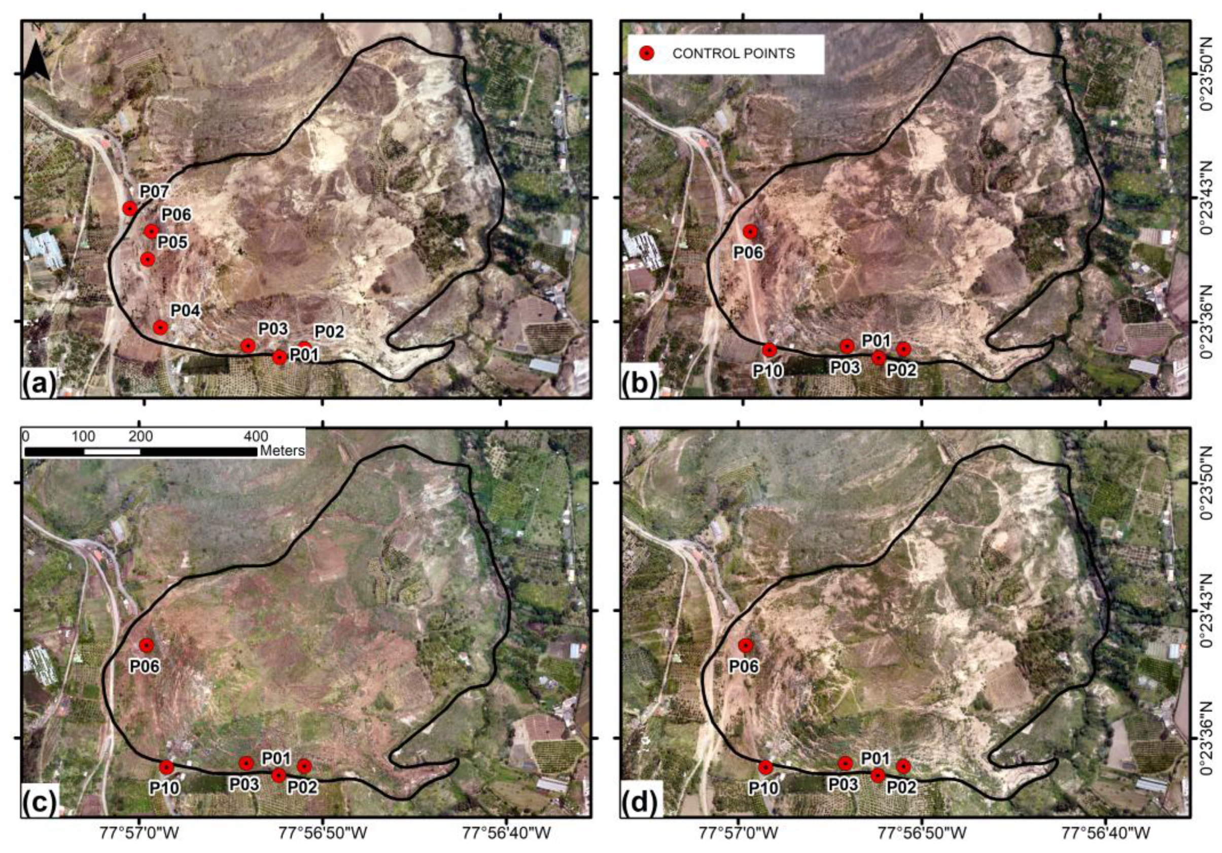
On September 12, 2022, 7 control points were installed in the field, points P04, P05, P06, P07 are distributed transversely on the landslide crown, points P01, P02 and P03 are located on the south side in the body of the landslide. Point P01 was installed at the top of the slope formed by the landslide and is located outside the event. Figure 3 (A) shows the distribution of the points.
Rapid static positioning is a GNSS technique that allows coordinates to be determined with high precision in relatively short observation periods, compared to traditional static positioning. It is based on the simultaneous occupation of a reference point and the point to be measured, resolving carrier phase ambiguities in minutes rather than hours. In this study, it was applied using Trimble R8 dual-frequency GNSS equipment which, according to the manufacturer, guarantees the following accuracies: ±5 mm + 0.5 ppm. According to [29], for baselines shorter than 5 km, it is possible to obtain acceptable accuracies with observation times between 15 and 20 minutes, provided that dual-frequency receivers are used and there is good satellite visibility. Hofmann-Wellenhof and Lichtenegger [30] also reinforce this criterion by pointing out that, under ideal conditions, short baselines allow effective observations to be made in 10 to 30 minutes, taking advantage of the stability of the ionosphere at short distances. In this case, the continuous monitoring station in Pimampiro (PIEC), belonging to the Ecuadorian GNSS Continuous Monitoring Network (REGME), located approximately 5 km from the site, was used as the basis for the monitoring baseline.
The second field campaign was carried out on January 7, 2023, with a demise of points P04, P05 and P07 due to earth movement by heavy machinery for the reopening of the road connecting with other towns, however, the repositioning of point 10 was performed, the GNSS positioning was performed with the same conditions as in the baseline. The third and fourth campaigns were carried out in 2023, April 22 and June 3, respectively, keeping the same characteristics.
Various authors have demonstrated the effectiveness of the use of geodetic microgrids for the monitoring of mass movements, highlighting their ability to detect millimeter displacements in unstable areas. Thus, in Colombia, Amórtegui and Martínez [27] designed and materialized a geodetic network in the municipality of Choachí, Cundinamarca, with the objective of monitoring the behavior of the terrain in the face of mass removal phenomena using precision GNSS. In Ecuador, Zárate and Ruiz [31] implemented a geodetic control network in an active slope in Loja, composed of 17 points measured with GNSS Trimble R6 receivers, allowing to establish relationships between the detected displacements by inserting a very important variable such as precipitation. Likewise, Tapia and Zárate [32]developed a GNSS network of 22 points in the city of Loja, applying the Fast Static technique, and evidenced displacements of up to 3 cm/year associated with tectonic and geomorphological processes. These more local experiences, added to the international investigations of Gili, Corominas and Rius [24] in the Catalan Pyrenees, and Takeshi and Akimichi [33] in Japan using permanent GNSS networks, consolidate the importance of geodetic micro networks as a key tool for geological risk management and landslide early warning.
Figure 3.
Multitemporal sequence of the study area from orthomosaics using RGB images for the four temporalities and location of GCP’s. (a) (12/09/2022), (b) (07/01/2023), (c) (22/04/2023), (d) (03/06/2023).
Figure 3.
Multitemporal sequence of the study area from orthomosaics using RGB images for the four temporalities and location of GCP’s. (a) (12/09/2022), (b) (07/01/2023), (c) (22/04/2023), (d) (03/06/2023).
Two years after the initial monitoring, two campaigns were carried out, in 2024, September 26, and November 14, 11 control points were materialized for a total of 16 control points. These actions were carried out with the purpose of generating a more robust geodetic micro network as well as improving the distribution of the points with the objective of covering more parts of the landslide from the crown to the foot of it, the middle part of the landslide was not feasible to densify due to the rugged topography and presence of cracks. The new configuration of the control points has 7 points located in the landslide crown, corresponding to points P04A, P05A, P06A, P07A, P08, P10, P11; on the south side of the landslide body, points P01, P02 and P03 continue to be monitored; in the lower part and at the foot of the landslide are points P15, P17, P18, P19, P20 and P21, Figure 4 shows the distribution of the densification of the control points.
3.2. Multispectral Imagery
Several multispectral imaging campaigns were conducted in the area affected by the landslide. The images obtained by specialized sensors allow the detection of different wavelengths of the electromagnetic spectrum, many of which are invisible to the human eye, such as the near infrared (NIR) band. The integration of these spectral bands enables the generation of indices and compositions that reveal key biophysical characteristics for terrain characterization, such as surface moisture content, vegetation cover and material differentiation [34,35].
Over the last decades, UAVs have established themselves as essential platforms for the acquisition of geospatial data in areas of difficult access and complex topography. In this case, given the conditions of the terrain affected by the landslide characterized by steep slopes, instability and the presence of geological scars-, the need was identified to use a UAV for the collection of high spatial and spectral resolution information. The DJI Matrice 600 Pro model was used, a professional category hexacopter, designed to operate with heavier payloads and with flight autonomy of up to 35 minutes, depending on the configuration of the payload and environmental conditions [36].
A Parrot Sequoia multispectral camera was used as payload, equipped with four independent sensors that capture images in the near infrared (NIR), red edge (Red Edge), red (Red) and green (Green) bands, in addition to a 16 MP RGB sensor. This camera is specifically designed for applications in precision agriculture and environmental studies, allowing the simultaneous acquisition of images in different spectral bands with high precision and synchronization [37]
Multispectral cameras allow capturing ground reflectance at various wavelengths, which facilitates the construction of spectral indices such as NDVI (Normalized Difference Vegetation Index), NDWI (Normalized Difference Water Index), or GNDVI (Green NDVI), widely used for the analysis of vegetation, soil moisture and detection of land surface disturbances [38,39]. These derived products are essential for multi-temporal and spatial analysis of areas affected by geodynamic processes such as landslides, as they allow the identification of subtle changes in land cover that may be early indicators of instability or evolution of the processes.
Prior to the start of aerial operations, a pre-programmed flight plan was designed and uploaded to the UAV controller, which was used consistently throughout the campaigns. The planning was aimed at achieving a balance between high-resolution imagery and operational efficiency, both in flight time and data processing. An altitude of 293 meters above ground level was defined, which allowed a ground sampling distance (GSD) of 8 cm/pixel, suitable for detailed analysis in unstable areas. The flight speed was set at 10 m/s, with an approximate duration of 15 minutes per flight and a total of 2947 images captured, ensuring adequate overlap and coverage of the study area. The camera was configured with a capture interval of 2.0 seconds, a focal length of 4.84 mm, a sensor width of 6.09 mm and an image resolution of 4608 × 3456 pixels. These parameters allow obtaining products with high radiometric and spatial quality, suitable for the analysis of vegetation cover and soil moisture, key aspects in the detection of areas susceptible to mass movements. All flight parameters used are listed in Table 1. Prior to each flight, radiometric calibration was performed using the Parrot Sequoia reflectance panel. This is an essential process for obtaining accurate reflectance measurements of vegetation and other targets in multispectral imagery.
The selection of these parameters responds to good practices in UAV photogrammetry for high-precision surveys. The chosen configuration allowed the generation of mapping products with high geometric and radiometric quality, while optimizing the available processing resources. This approach has been widely validated in studies employing UAV platforms for monitoring slope dynamics, due to its ability to capture detailed information in difficult to access environments [40,41]
The integration of multispectral data acquired from UAV with other sources of geospatial information provides a powerful tool for the assessment of natural hazards, particularly in Andean contexts where geomorphological complexity limits the use of traditional monitoring methods.
Orthorectification of RGB and multispectral images captured by UAV is a fundamental step in the photogrammetric workflow, especially when seeking to generate accurate and georeferenced cartographic products for subsequent geospatial analysis and integration into Geographic Information Systems (GIS) [42]. The images were processed in Pix4Dmapper software, defining the geodetic reference system WGS84, zone 18N. During the initial stage, the software recognizes the metadata associated with each image type and runs an automatic calibration to estimate the internal orientation of the frames and generate a point cloud from homologous matches [43]. The external orientation of the photogrammetric adjustment was optimized using the ground control points (GCPs) mentioned in the previous section, measured with dual-frequency GNSS receivers. To ensure the quality of the orthorectification, the image acquisition was planned with an overlap greater than 70 %, in addition to achieving a root mean square error (RMS) of less than 0.1 m, a value considered acceptable for high-resolution studies [44,45]
As final products, Pix4D generated digital surface models (DSM), digital terrain models (DTM) through point cloud classification, geometrically corrected orthomosaics, and a quality report validating the spatial adjustment for both RGB and multispectral images.
3.2.1. NDWI & NDVI Calculation
Spectral indices are fundamental tools in the remote analysis of the biophysical conditions of the terrain, particularly in the assessment of the state of vegetation and surface moisture. These indices are mathematical derivatives calculated from the reflectance obtained in different bands of the electromagnetic spectrum, recorded by multispectral sensors during the photogrammetric survey [46].
Once the multispectral images acquired in the field were processed, two spectral indices commonly used in landslide susceptibility studies were generated: the NDVI (Normalized Difference Vegetation Index) and the NDWI (Normalized Difference Water Index), calculated using the formulas described in Table 2. These metrics have been used as auxiliary variables for the indirect estimation of slope instability, since variations in vegetation cover and in the water content of the soil and vegetation can reflect underlying processes of saturation and infiltration that promote material sliding [47,48].
NDVI, by quantifying the vigour and density of vegetation, allows the identification of areas with abrupt changes in vegetation cover, which may be associated with surface disturbances due to mass movements [37].On the other hand, NDWI, which is sensitive to water content in vegetation and soil, has proven useful in detecting areas with high surface moisture, which is a key factor in triggering landslides [51,52]
4. Results
4.1. Apparent Displacement Estimation
Based on the data collected in the field during each of the campaigns, displacement was determined and bearing values were obtained. Table 3 shows the continuous monitoring data up to the sixth follow-up for control points P01, P02, P03, P06, and P10 with respect to the initial monitoring on September 12, 2022.
Table 4 shows 11 control points that were densified, observing their displacements and information acquisition courses on September 26, 2024, corresponding to campaign V of this study. The control points materialized correspond to: P04A, P05A, P06A, P07A, P08, P11, P15, P17, P18, P19, P20, and P21.
Points P04A, P05A, and P11 are located on the outer edge of the landslide crown, but show average displacements of 0.016 m at distances between 30 and 40 meters toward the crown. Points P06A, P07A, and P08, located at the top of the landslide at 40, 60, and 130 meters from the crown, respectively, show average displacements of 0.029 meters in a northwest direction, contrary to the general expected movement in a northeast direction, as in point P08. Point P10 is aligned with the previous points but located at the edge of the landslide approximately 4 meters away, with an average displacement of 0.017 meters in a northeast direction. On the south side, on the flank of the landslide, points P02 and P03 are located, with average displacements of 0.043 and 0.024 meters in a north and northeast direction, respectively. On the wall of the landslide, between points P02 and P03, point P01 is located on the outer edge, with an average displacement of 0.043 meters and a predominance towards the southeast. Points P18, P19, P20, and P21 are located in the lower part of the landslide body, with average displacements of 0.035 meters, P20 having the greatest displacement of 0.066 m in a northwest direction. Finally, points P15 and P17, also in the lower part, show displacements of 0.029 m in the southwest and southeast directions, respectively. Figure 4 shows the spatial distribution of each of the points monitored in each campaign, distinguished by colors that indicate the apparent direction of movement from top to bottom.
4.2. Multispectral Index Analysis
4.2.1. Normalized Water Index (NDWI)
Analysis of the Normalized Difference Water Index (NDWI) identified the areas with the highest surface moisture content in the study area, as well as their temporal variability according to the wet and dry seasons. The maps generated (Figure 5) show that the central areas of the landslide and the fissure system had the highest NDWI values, indicating a higher concentration of moisture in those areas. Sections with positive values were identified, especially at the crown and base, suggesting the persistence of moisture even during dry periods.
Table 5 presents the classification applied to the NDWI, differentiating between non-aquatic surfaces, wet soils, turbid water, and deep-water bodies.
4.2.2. Normalized Difference Vegetation Index (NDVI)
NDVI analysis revealed a continuous increase in vegetation cover throughout the study period (Figure 6). NDVI values, which range from -1 to 1, showed an upward trend, indicating progressive vegetation recolonization in the landslide area.
Table 6 presents the NDVI classification, which differentiates between areas without vegetation and dense forests and tropical rainforests. [49,57,58].
Figure 7 shows the percentage variation in land cover according to NDVI values, with a decrease in the range 0.1-0.3 (dry grass/bare soil) and an increase in the ranges 0.5-0.7 and 0.7-1, corresponding to robust and very dense vegetation.
Figure 8, on the other hand, shows the contrast with the NDWI, where wet areas decrease over time, while cracks with residual moisture persist.
5. Discussion
The results obtained through GNSS monitoring show the existence of differential displacement patterns within the landslide, reflecting the heterogeneity in the geomorphological and geomechanical response of the terrain. The record of variable displacements between the different control points confirms that the instability process does not act homogeneously, but is conditioned by the location, the morphology of the relief, and the dynamics of the materials involved. In particular, the greater magnitude of displacement observed at point P20 (0.066 m) indicates that the lower part of the landslide body continues to be the most active, a situation consistent with its location at the front, where the energy of the movement is concentrated and where the dragging of materials is most evident. This condition has been reported in other studies of slope dynamics, where active fronts maintain higher rates of movement due to the accumulation of stress and the loss of basal support. [59,60]
In contrast, points located near the crown show significantly lower displacement values, suggesting relative stabilization processes in those areas. This stabilization could be explained both by the progressive loss of energy in the upper part of the landslide and by revegetation processes that provide additional cohesion to the soil. However, the presence of fissures detected in field campaigns, associated with residual moisture in the crown, indicates that these areas should not be considered completely stable, but rather in a state of latent susceptibility, liable to reactivate in response to triggering events such as heavy rains or moderate earthquakes.
The analysis of spectral indices supports and complements these interpretations derived from GNSS. The Normalized Difference Water Index (NDWI) showed a gradual reduction over time, which is interpreted as an increase in vegetation cover and a reduction in bare soil exposure. This finding is consistent with that reported by Cobos-Mora [61], who highlight that revegetation processes, whether natural or induced, are indirect indicators of slope stabilization. However, the persistence of high NDWI values in specific areas of the crown and base confirms the presence of localized moisture. This pattern is consistent with studies such as those by Torres-Quezada [52], which indicate that the accumulation of moisture in fissures and low-lying areas of the landslide acts as a critical factor in the generation of pore pressures, reducing shear strength and favoring the reactivation of mass movements.
For its part, the Normalized Difference Vegetation Index (NDVI) showed a sustained increase in vegetation cover during the study period, indicating progressive surface consolidation of the terrain. This evolution is consistent with the findings of Pradhan [62] and Song [63], who demonstrate that vegetation plays a crucial role in slope stabilization by increasing soil cohesion through root networks and reducing surface erosion. However, this stabilizing effect should not be overestimated, as vegetation cover, although beneficial, does not eliminate the susceptibility of the terrain to instability, especially during seasons of high precipitation [64]. In this sense, vegetation can be considered a mitigating factor for surface processes, but not an element that guarantees long-term stability in the face of extreme hydrogeological conditions.
The methodological crossover between precision geodetic data and multitemporal spectral analysis is one of the key contributions of this study. While GNSS data allow us to identify and quantify the areas with the greatest active displacement, spectral indices provide information on environmental variables related to humidity and vegetation, which act as determinants of the mechanical behavior of the landslide. This methodological complementarity offers a comprehensive view of the dynamics of the terrain, as also suggested by Casagli [65], who highlight the need for multiscale and multisensory approaches in the monitoring of mass movements. In this case, the integration of both techniques not only allows for the interpretation of current processes, but also for the establishment of early warning criteria and the prioritization of risk areas.
The results have direct implications for risk management and the design of mitigation measures. On the one hand, identifying sectors with differential displacement allows critical areas to be prioritized, such as the lower part of the landslide, where the greatest risks to infrastructure and populations are concentrated. On the other hand, the recognition of persistent wet fissures at the crown and base of the landslide suggests the need to implement surface and underground drainage systems, as well as to reinforce controlled revegetation strategies with deep-rooted species that promote soil stability. Similarly, the results reinforce the relevance of maintaining a continuous monitoring system, combining permanent GNSS stations with periodic analysis of satellite images, in order to detect subtle variations in stability conditions before they translate into catastrophic movements.
Finally, the findings suggest that, although the study area shows a trend toward progressive stabilization, conditions of instability persist that require priority attention. Areas with persistent moisture and differential displacement should be considered critical points in future monitoring and mitigation plans. It is also recommended to advance research that integrates detailed hydrogeological analyses, numerical stability modeling, and the incorporation of climate data projected under climate change scenarios, considering that the increase in the frequency and intensity of precipitation can act as an amplifying factor in instability processes. In this sense, the present study not only contributes to scientific knowledge of landslides in Andean environments but also provides a solid technical basis for decision-making in land management, aligned with the principles of prevention, resilience, and sustainability.
6. Conclusions
After at least four monitoring campaigns using a multispectral sensor, the NDWI and NDVI indices reveal the evolution of the landslide. The first monitoring is particularly crucial, as it shows clear soil saturation, with at least 60% of the surface exhibiting moisture-related values. When contrasted with the NDVI index, low values are observed, associated with bare soil or sparse vegetation, thereby reinforcing the value of this type of information. Subsequent monitoring reveals the progression of the landslide in terms of vegetation cover, with at least 80% of the landslide surface becoming vegetated. However, areas with visible cracks remain unvegetated, and the NDWI index still shows moisture values that, although insignificant in terms of surface area, must be considered, as water could infiltrate deeper substrates through them.
Monitoring using GNSS techniques proved to be highly valuable for this type of landslide. Once the mass movement event occurred, continuous monitoring was carried out to determine activity or relative displacements through a geodetic micro-network, which was densified with a total of 16 vertices distributed across the landslide. This network revealed the displacement behavior. In the upper part, particularly near the crown, displacements were minor and mainly associated with cracks, rather than the expected general movement towards the east. The lower part or toe of the landslide exhibited a contradictory displacement towards the northwest, which was consistent across several vertices, thereby ruling out measurement errors. This anomalous displacement detected by the GNSS monitoring technique should be cross-validated with other measurement methods such as DInSAR, to confirm this behavior. Additionally, more detailed studies from a geotechnical or geological perspective should be conducted.
The integration of GNSS and UAV-mounted multispectral sensors is confirmed as an effective and necessary methodology for landslide monitoring, as it not only enables the detection of differential displacements with high precision but also identifies moisture conditions and vegetation cover that directly influence slope stability. The results indicate that, although there is a process of vegetation recolonization that favors stabilization, persistent moisture within cracks represents active instability hotspots that could reactivate the phenomenon. The applicability of this approach goes beyond the academic sphere, as it provides direct tools for the implementation of early warning systems and territorial planning in risk-prone areas, becoming a replicable strategy in different Andean and Latin American contexts for the effective reduction of vulnerability to mass movements.
Author Contributions
Conceptualization, K.F.-Q., S.A.-S., F.C.-M., and M.D.-Q.; methodology, K.F.-Q. and S.A.-S.; software, K.F.-Q. and S.A.-S.; validation, K.F.-Q., S.A.-S and F.C.-M.; formal analysis K.F.-Q. and S.A.-S.; investigation, K.F.-Q., S.A.-S., F.C.-M., and M.D.-Q.; resources, K.F.-Q.; data curation, K.F.-Q., S.A.-S and F.C.-M.; writing—original draft preparation, all authors; writing—review and editing, K.F.-Q. and S.A.-S; visualization, K.F.-Q., S.A.-S and F.C.-M.; supervision, K.F.-Q.; project administration, K.F.-Q. All authors have read and agreed to the published version of the manuscript.
Funding
This research received no external funding. The APC was funded by Yachay Experimental Technology Research University.
Data Availability Statement
The raw data supporting this article will be made available by the authors on request.
Acknowledgments
The research team would like to express its gratitude to Imbabura Geopark, Yachay Experimental Technological Research University, and the Pimampiro Municipal Government for their invaluable support and encouragement throughout the research process.
Conflicts of Interest
The authors declare no conflicts of interest.
References
- M. Scaioni, L. Longoni, V. Melillo, and M. Papini, “remote sensing Remote Sensing for Landslide Investigations: An Overview of Recent Achievements and Perspectives,” Remote Sens, vol. 6, p. 1, 2014. [CrossRef]
- T. Peternel, Š. Kumelj, K. Oštir, and M. Komac, “Monitoring the Potoška planina landslide (NW Slovenia) using UAV photogrammetry and tachymetric measurements,” Landslides, vol. 14, no. 1, pp. 395–406, Feb. 2017. [CrossRef]
- C. Squarzoni, C. Delacourt, and P. Allemand, “Differential single-frequency GPS monitoring of the La Valette landslide (French Alps),” Eng Geol, vol. 79, no. 3–4, pp. 215–229, Jul. 2005. [CrossRef]
- T. Yang, J. K. Park, and D. M. Kim, “Monitoring the Symptoms of Landslide Using the Non-Prism Total Station,” 2007.
- J.-P. Malet, O. Maquaire, and E. Calais, “The use of Global Positioning System techniques for the continuous monitoring of landslides: application to the Super-Sauze earthf low (Alpes-de-Haute-Provence, France).” [Online]. Available: www.elsevier.com/locate/geomorph.
- R. M. Mateos et al., “The combined use of PSInSAR and UAV photogrammetry techniques for the analysis of the kinematics of a coastal landslide affecting an urban area (SE Spain),” Landslides, vol. 14, no. 2, pp. 743–754, Apr. 2017. [CrossRef]
- V. Tofani, F. Raspini, F. Catani, and N. Casagli, “Persistent scatterer interferometry (psi) technique for landslide characterization and monitoring,” Remote Sens (Basel), vol. 5, no. 3, pp. 1045–1065, Mar. 2013. [CrossRef]
- M. A. Brideau et al., “Stability analysis of the 2007 Chehalis lake landslide based on long-range terrestrial photogrammetry and airborne LiDAR data,” Landslides, vol. 9, no. 1, pp. 75–91, Mar. 2012. [CrossRef]
- R. Prokešová, M. Kardoš, and A. Medveďová, “Landslide dynamics from high-resolution aerial photographs: A case study from the Western Carpathians, Slovakia,” Geomorphology, vol. 115, no. 1–2, pp. 90–101, Feb. 2010. [CrossRef]
- D. Turner, A. Lucieer, and C. Watson, “Development of an Unmanned Aerial Vehicle (UAV) for hyper resolution vineyard mapping based on visible, multispectral, and thermal imagery,” 2022.
- M. V. Peppa, J. P. Mills, P. Moore, P. E. Miller, and J. E. Chambers, “ACCURACY ASSESSMENT OF A UAV-BASED LANDSLIDE MONITORING SYSTEM,” The International Archives of the Photogrammetry, Remote Sensing and Spatial Information Sciences, vol. XLI-B5, pp. 895–902, Jun. 2016. [CrossRef]
- D. Zuliani, L. Tunini, F. Di Traglia, M. Chersich, and D. Curone, “Cost-Effective, Single-Frequency GPS Network as a Tool for Landslide Monitoring,” Sensors, vol. 22, no. 9, May 2022. [CrossRef]
- X. Ma, Z. Wang, and Y. Liu, “Ecological risk assessment of a coastal area using multi-source remote sensing images and in-situ sample data,” Ecol Indic, vol. 158, Jan. 2024. [CrossRef]
- J. M. Espinosa-Herrera, A. Macedo-Cruz, D. S. Fernández-Reynoso, H. Flores-Magdaleno, Y. M. Fernández-Ordoñez, and J. Soria-Ruíz, “Monitoring and Identification of Agricultural Crops through Multitemporal Analysis of Optical Images and Machine Learning Algorithms,” Sensors, vol. 22, no. 16, Aug. 2022. [CrossRef]
- Z. Hao et al., “Multitemporal Analysis of Urbanization-Driven Slope and Ecological Impact Using Machine-Learning and Remote Sensing Techniques,” IEEE J Sel Top Appl Earth Obs Remote Sens, vol. 18, pp. 1876–1895, 2025. [CrossRef]
- V. L. Doan, B. Q. V. Nguyen, H. T. Pham, C. C. Nguyen, and C. T. Nguyen, “Effect of time-variant NDVI on landside susceptibility: A case study in Quang Ngai province, Vietnam,” Open Geosciences, vol. 15, no. 1, Jan. 2023. [CrossRef]
- H. Albanwan, R. Qin, and J. K. Liu, “Remote Sensing-Based 3D Assessment of Landslides: A Review of the Data, Methods, and Applications,” Feb. 01, 2024, Multidisciplinary Digital Publishing Institute (MDPI). [CrossRef]
- Gobierno Autónomo Descentralizado Municipal San Pedro de Pimampiro, “PDyOT Pimampiro 2030,” 2023. Accessed: Jul. 15, 2025. [Online]. Available: https://www.pimampiro.gob.ec/images/noticias/documentos/PDyOT_2030.pdf.
- B. A. Flores Quilca, “Estudio Geológico – Estructural de la zona de Pimampiro 1:25.000 entre las longitudes 78°00’ y 77°52’ O y las latitudes 0°20’ y 0°25’N,” Quito, 2023. Accessed: Jul. 15, 2025. [Online]. Available: chrome-extension://efaidnbmnnnibpcajpcglclefindmkaj/https://www.dspace.uce.edu.ec/server/api/core/bitstreams/79451e54-1c56-41ee-8e08-9abdb3ba62f5/content.
- M. Litherland, J. A. Aspden, and R. A. Jemielita, “The metamorphic belts of Ecuador,” Murchison, 1994. Accessed: Jul. 15, 2025. [Online]. Available: chrome-extension://efaidnbmnnnibpcajpcglclefindmkaj/https://dn790009.ca.archive.org/0/items/1994-litherland-the-metamorphic-belts-of-ecuador-sp/1994_LITHERLAND_THE_METAMORPHIC_BELTS_OF_ECUADOR_SP.pdf.
- O. Alonso-Pandavenes, F. J. Torrijo Echarri, and J. Garzón-Roca, “Sustainable Management of Landslides in Ecuador: Leveraging Geophysical Surveys for Effective Risk Reduction,” Sustainability (Switzerland), vol. 16, no. 24, Dec. 2024. [CrossRef]
- INAMHI, “GEOGLOWS.” Accessed: Mar. 15, 2022. [Online]. Available: https://inamhi.geoglows.org/apps/met-data-explorer.
- USGS, “Monitoring Ground Deformation from Space,” 2005, [Online]. Available: http://earthquake.usgs.gov/products/.
- J. A. Gili, J. Corominas, and J. Rius, “Using Global Positioning System techniques in landslide monitoring,” 2000. [Online]. Available: www.elsevier.nl/locate/enggeo.
- F. Tagliavini, M. Mantovani, G. Marcato, A. Pasuto, and S. Silvano, “Validation of landslide hazard assessment by means of GPS monitoring technique-a case study in the Dolomites (Eastern Alps, Italy),” 2007. [Online]. Available: www.nat-hazards-earth-syst-sci.net/7/185/2007/.
- G. Huang, S. Du, and D. Wang, “GNSS techniques for real-time monitoring of landslides: a review,” Dec. 01, 2023, Springer. [CrossRef]
- P. Y. Ajuste De Una Red, “INFORME FINAL DE PASANTÍA,” 2016.
- P. Y. Ajuste De Una Red and F. DE JAVIER SANDOVAL CANTOR Proyecto Realizado Para Optar Al Título De Ingeniero Topográfico Modalidad Pasantía UNIVERSIDAD DISTRITAL FRANCISCO JOSÉ CALDAS, “INFORME FINAL DE PASANTÍA.”.
- , Lev Rapoport Ph.D,, Dmitry Tatarnikov Ph.D, Alfred Leick Ph.D, “GNSS Positioning Approaches,” in GPS Satellite Surveying, John Wiley & Sons, Ltd., 2015, ch. 6, pp. 257–399. [CrossRef]
- H. and C. J. Hofmann-Wellenhof Bernhard and Lichtenegger, “Data Processing,” in Global Positioning System: Theory and Practice, Vienna: Springer Vienna, 2001, pp. 203–278. [CrossRef]
- V. S. Ruiz Calvache and B. A. M. S. Zárate Torres, “UNIVESIDAD TÉCNICA PARTICULAR DE LOJA ÁREA TÉCNICA,” 2017. Accessed: Sep. 07, 2025. [Online]. Available: https://dspace.utpl.edu.ec/handle/20.500.11962/20721.
- I. S. Tapia Carreño and B. A. Zárate Torres, “UNIVERSIDAD TÉCNICA PARTICULAR DE LOJA ÁREA TÉCNICA INGENIERO CIVIL,” 2021. Accessed: Sep. 07, 2025. [Online]. Available: https://dspace.utpl.edu.ec/visorHub/?handle=20.500.11962_28767.
- T. Matsushima and A. Takagi, “GPS and EDM monitoring of Unzen volcano ground deformation,” 2000.
- S. Pesaresi, A. Mancini, G. Quattrini, and S. Casavecchia, “Evaluation and Selection of Multi-Spectral Indices to Classify Vegetation Using Multivariate Functional Principal Component Analysis,” Remote Sens (Basel), vol. 16, no. 7, Apr. 2024. [CrossRef]
- J. Sun, G. Yuan, L. Song, and H. Zhang, “Unmanned Aerial Vehicles (UAVs) in Landslide Investigation and Monitoring: A Review,” Jan. 01, 2024, Multidisciplinary Digital Publishing Institute (MDPI). [CrossRef]
- R. J. Ruiz, J. L. Saravia, V. H. Andaluz, and J. S. Sánchez, “Virtual Training System for Unmanned Aerial Vehicle Control Teaching–Learning Processes,” Electronics (Switzerland), vol. 11, no. 16, Aug. 2022. [CrossRef]
- R. S. de Lima et al., “The Potential of Optical UAS Data for Predicting Surface Soil Moisture in a Peatland across Time and Sites,” Remote Sens (Basel), vol. 14, no. 10, May 2022. [CrossRef]
- Z. Stamenković et al., “Assessing the Impact of UAV Flight Altitudes on the Accuracy of Multispectral Indices,” Contemporary Agriculture, vol. 73, no. 3–4, pp. 157–164, Dec. 2024. [CrossRef]
- S. B. Bhagya et al., “Landslide Susceptibility Assessment of a Part of the Western Ghats (India) Employing the AHP and F-AHP Models and Comparison with Existing Susceptibility Maps,” Land (Basel), vol. 12, no. 2, Feb. 2023. [CrossRef]
- K. G. Nikolakopoulos, A. Kyriou, and I. K. Koukouvelas, “UAV, GNSS, and GIS for the Rapid Assessment of Multi-Occurrence Landslides,” Geosciences (Switzerland), vol. 14, no. 6, Jun. 2024. [CrossRef]
- P. L. N. Raju et al., “Applications of UAV Remote Sensing-Case examples of North Eastern Region.”.
- P. Reinartz, R. Müller, P. Schwind, S. Suri, and R. Bamler, “Orthorectification of VHR optical satellite data exploiting the geometric accuracy of TerraSAR-X data,” ISPRS Journal of Photogrammetry and Remote Sensing, vol. 66, no. 1, pp. 124–132, Jan. 2011. [CrossRef]
- S. Jarahizadeh and B. Salehi, “A Comparative Analysis of UAV Photogrammetric Software Performance for Forest 3D Modeling: A Case Study Using AgiSoft Photoscan, PIX4DMapper, and DJI Terra,” Sensors, vol. 24, no. 1, Jan. 2024. [CrossRef]
- İ. E. Saglam and L. Karasaka, “Evaluation of multi-camera images in different SfM-MVS based photogrammetric software and comparison of digital products in generating 3D city models,” Ain Shams Engineering Journal, vol. 15, no. 5, May 2024. [CrossRef]
- Y. Yang et al., “Characteristics analysis of the reservoir landslides base on unmanned aerial vehicle (UAV) scanning technology at the Maoergai Hydropower Station, Southwest China,” in IOP Conference Series: Earth and Environmental Science, Institute of Physics Publishing, Oct. 2019. [CrossRef]
- N. Yaa’Cob, Z. N. A. Abd Rashid, N. Tajudin, and M. Kassim, “Landslide Possibilities using Remote Sensing and Geographical Information System (GIS),” in IOP Conference Series: Earth and Environmental Science, Institute of Physics Publishing, Aug. 2020. [CrossRef]
- M. L. Mohd Yaacob et al., “Rock slope monitoring using drone based multispectral and thermal images,” in IOP Conference Series: Earth and Environmental Science, Institute of Physics Publishing, Aug. 2020. [CrossRef]
- M. Yavuz et al., “Identification of Streamside Landslides with the Use of Unmanned Aerial Vehicles (UAVs) in Greece, Romania, and Turkey,” Remote Sens (Basel), vol. 15, no. 4, Feb. 2023. [CrossRef]
- R. W. H. Rouse, J. A. W. Haas, and D. W. Deering, “’aper A 20 MONITORING VEGETATION SYSTEMS IN THE GREAT PLAINS WITH ERTS.”.
- S. K. McFeeters, “The use of the Normalized Difference Water Index (NDWI) in the delineation of open water features,” Int J Remote Sens, vol. 17, no. 7, pp. 1425–1432, 1996. [CrossRef]
- E. Özelkan, “Water body detection analysis using NDWI indices derived from landsat-8 OLI,” Pol J Environ Stud, vol. 29, no. 2, pp. 1759–1769, 2020. [CrossRef]
- E. Torres-Quezada et al., “Remote Sensing and Soil Moisture Sensors for Irrigation Management in Avocado Orchards: A Practical Approach for Water Stress Assessment in Remote Agricultural Areas,” Remote Sens (Basel), vol. 17, no. 4, Feb. 2025. [CrossRef]
- S. Gantimurova and A. Parshin, “Combined Methodology for Rockfall Susceptibility Mapping Using UAV Imagery Data,” Remote Sens (Basel), vol. 16, no. 1, Jan. 2024. [CrossRef]
- M. Kazemi Garajeh, A. Guariglia, P. Paridad, R. Santangelo, V. Satriano, and V. Tramutoli, “Detecting small-scale landslides along electrical lines using robust satellite-based techniques,” Geomatics, Natural Hazards and Risk, vol. 15, no. 1, 2024. [CrossRef]
- B.-C. Gao, “Naval Research Laboratory, 4555 Overlook Ave,” ©Elsevier Science Inc, 1996.
- H. Xu, “Modification of normalised difference water index (NDWI) to enhance open water features in remotely sensed imagery,” Int J Remote Sens, vol. 27, no. 14, pp. 3025–3033, Jul. 2006. [CrossRef]
- C. J. Tucker, “Red and Photographic Infrared l,lnear Combinations for Monitoring Vegetation,” 1979.
- A. Huete, K. Didan, T. Miura, E. P. Rodriguez, X. Gao, and L. G. Ferreira, “Overview of the radiometric and biophysical performance of the MODIS vegetation indices.” [Online]. Available: www.elsevier.com/locate/rse.
- D. M. Cruden and D. J. Varnes, “Landslide Types and Processes, Transportation Research Board,” 1996.
- F. Guzzetti, A. C. Mondini, M. Cardinali, F. Fiorucci, M. Santangelo, and K. T. Chang, “Landslide inventory maps: New tools for an old problem,” Apr. 2012. [CrossRef]
- S. L. Cobos-Mora, V. Rodriguez-Galiano, and A. Lima, “Analysis of landslide explicative factors and susceptibility mapping in an andean context: The case of Azuay province (Ecuador),” Heliyon, vol. 9, no. 9, Sep. 2023. [CrossRef]
- B. Pradhan, A. Chaudhari, J. Adinarayana, and M. F. Buchroithner, “Soil erosion assessment and its correlation with landslide events using remote sensing data and GIS: A case study at Penang Island, Malaysia,” Environ Monit Assess, vol. 184, no. 2, pp. 715–727, 2012. [CrossRef]
- Y. Song et al., “Evaluating Landslide Susceptibility Using Sampling Methodology and Multiple Machine Learning Models,” ISPRS Int J Geoinf, vol. 12, no. 5, May 2023. [CrossRef]
- M. A. Aman, H.-J. Chu, S. R. Patra, and V. Kumar, “Rapid Mapping of Rainfall-Induced Landslide Using Multi-Temporal Satellite Data,” Remote Sens (Basel), vol. 17, no. 8, p. 1407, Apr. 2025. [CrossRef]
- N. Casagli et al., “Spaceborne, UAV and ground-based remote sensing techniques for landslide mapping, monitoring and early warning,” Geoenvironmental Disasters, vol. 4, no. 1, Dec. 2017. [CrossRef]
Figure 1.
Location of the landslide in the parish of Aloburo, canton Pimampiro, province of Imbabura. The image shows the area affected by the event, delimited in the field. In addition, a comparative graph of topographic profiles generated from the Digital Terrain Model (DTM) obtained by photogrammetry with UAV in 2022 and the official DTM of 2014 provided by the SIGTIERRAS project is included. The comparison shows morphological changes in the terrain associated with mass movement.
Figure 1.
Location of the landslide in the parish of Aloburo, canton Pimampiro, province of Imbabura. The image shows the area affected by the event, delimited in the field. In addition, a comparative graph of topographic profiles generated from the Digital Terrain Model (DTM) obtained by photogrammetry with UAV in 2022 and the official DTM of 2014 provided by the SIGTIERRAS project is included. The comparison shows morphological changes in the terrain associated with mass movement.
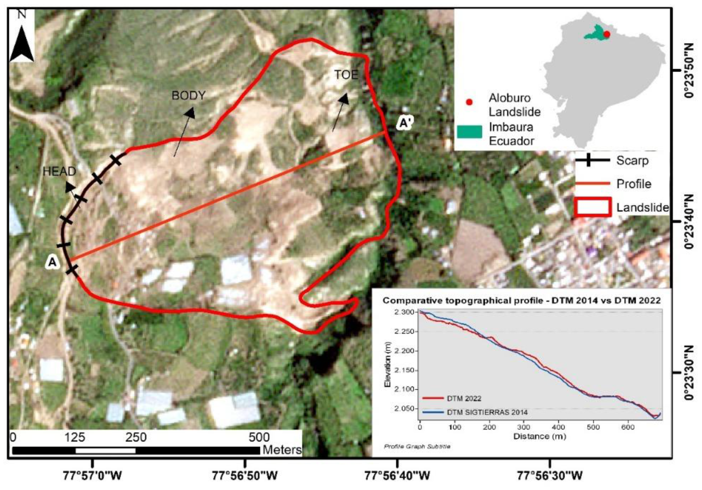
Figure 2.
Conceptual diagram illustrating the five stages of the process.
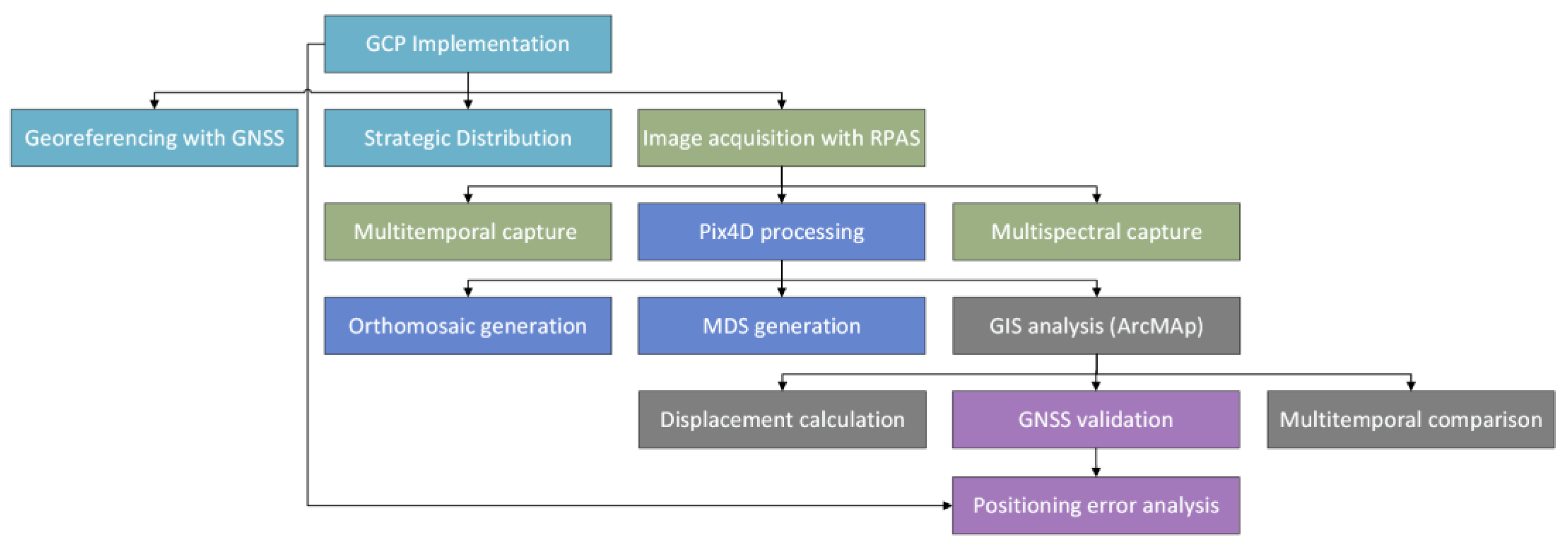
Figure 4.
Spatial distribution and apparent direction of control points in campaigns.
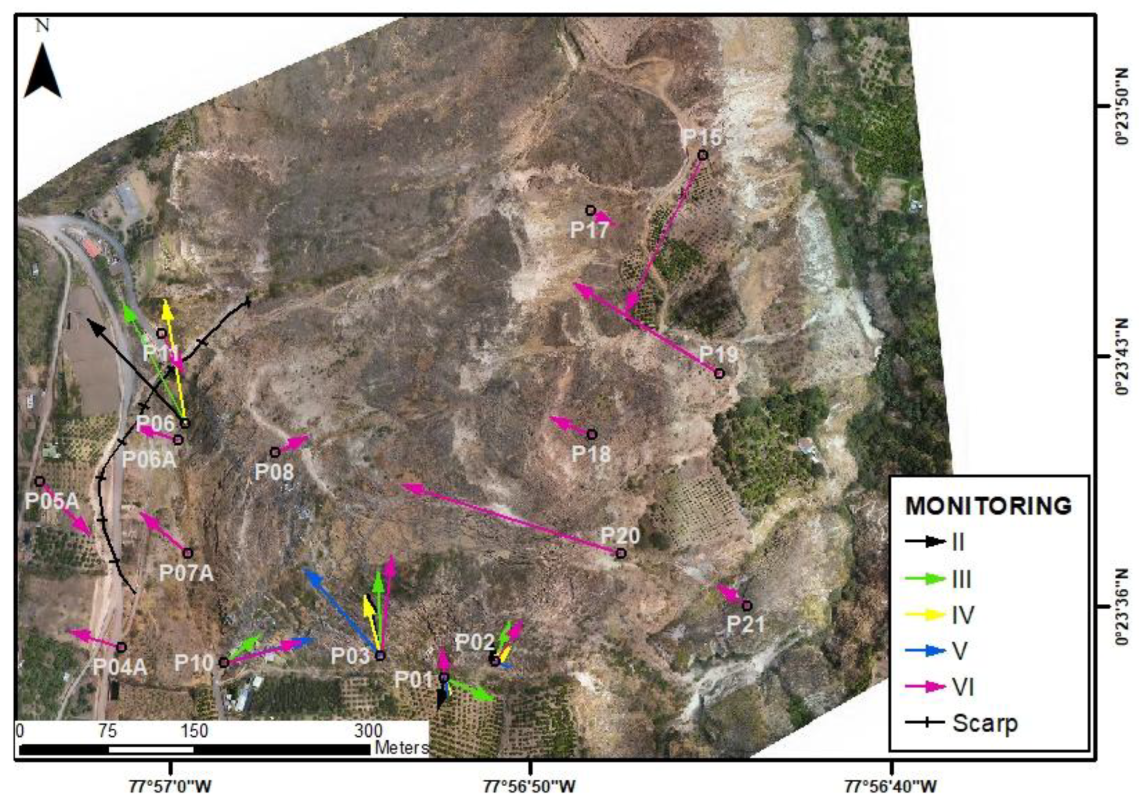
Figure 5.
Multitemporal sequence of NDWI calculation for the four time periods in the landslide area. (a) (12/09/2022), (b) (07/01/2023), (c) (22/04/2023), (d) (03/06/2023).
Figure 5.
Multitemporal sequence of NDWI calculation for the four time periods in the landslide area. (a) (12/09/2022), (b) (07/01/2023), (c) (22/04/2023), (d) (03/06/2023).
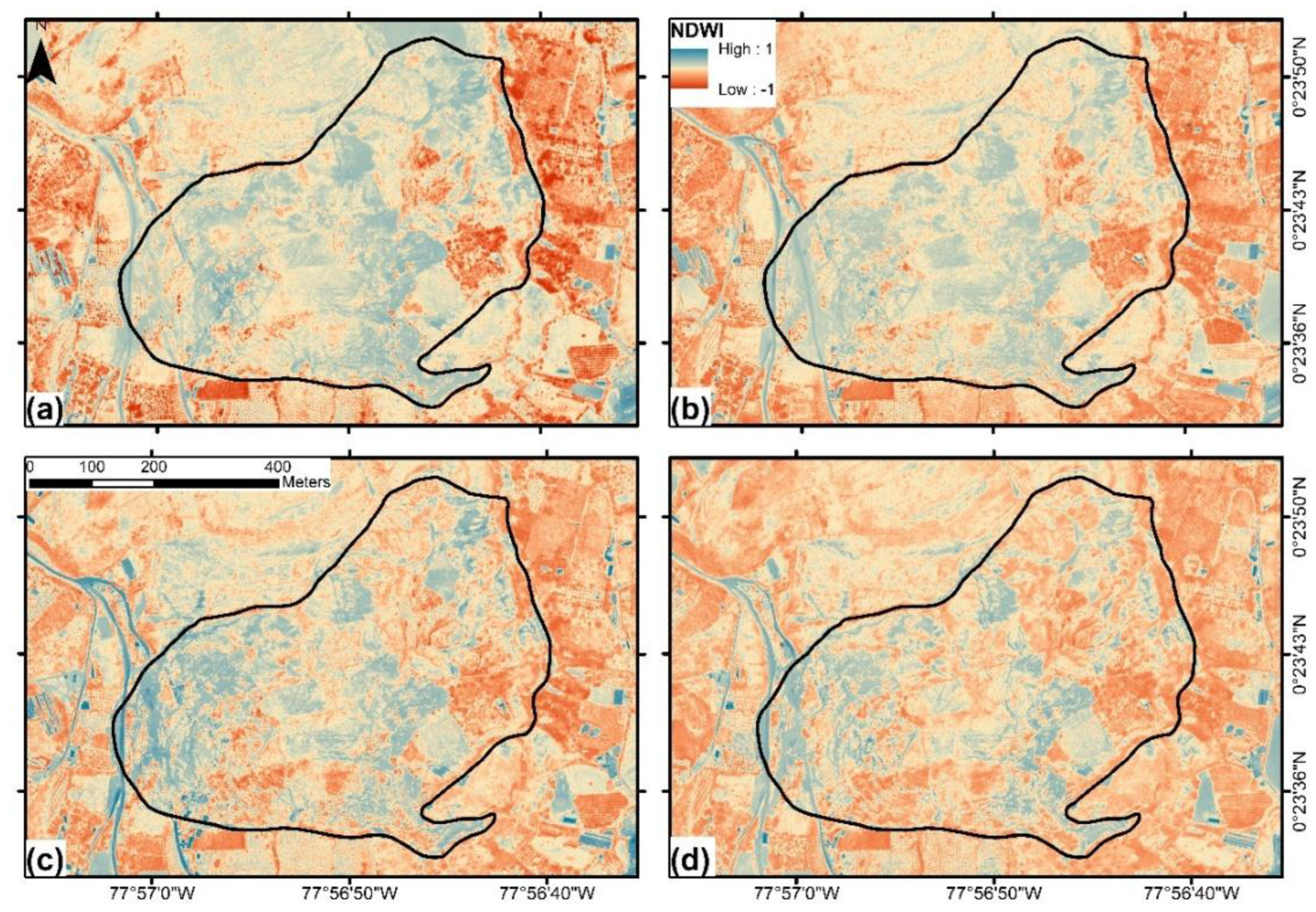
Figure 6.
Multitemporal sequence of NDVI calculation for the four time periods in the landslide area. (a) (12/09/2022), (b) (07/01/2023), (c) (22/04/2023), (d) (03/06/2023).
Figure 6.
Multitemporal sequence of NDVI calculation for the four time periods in the landslide area. (a) (12/09/2022), (b) (07/01/2023), (c) (22/04/2023), (d) (03/06/2023).
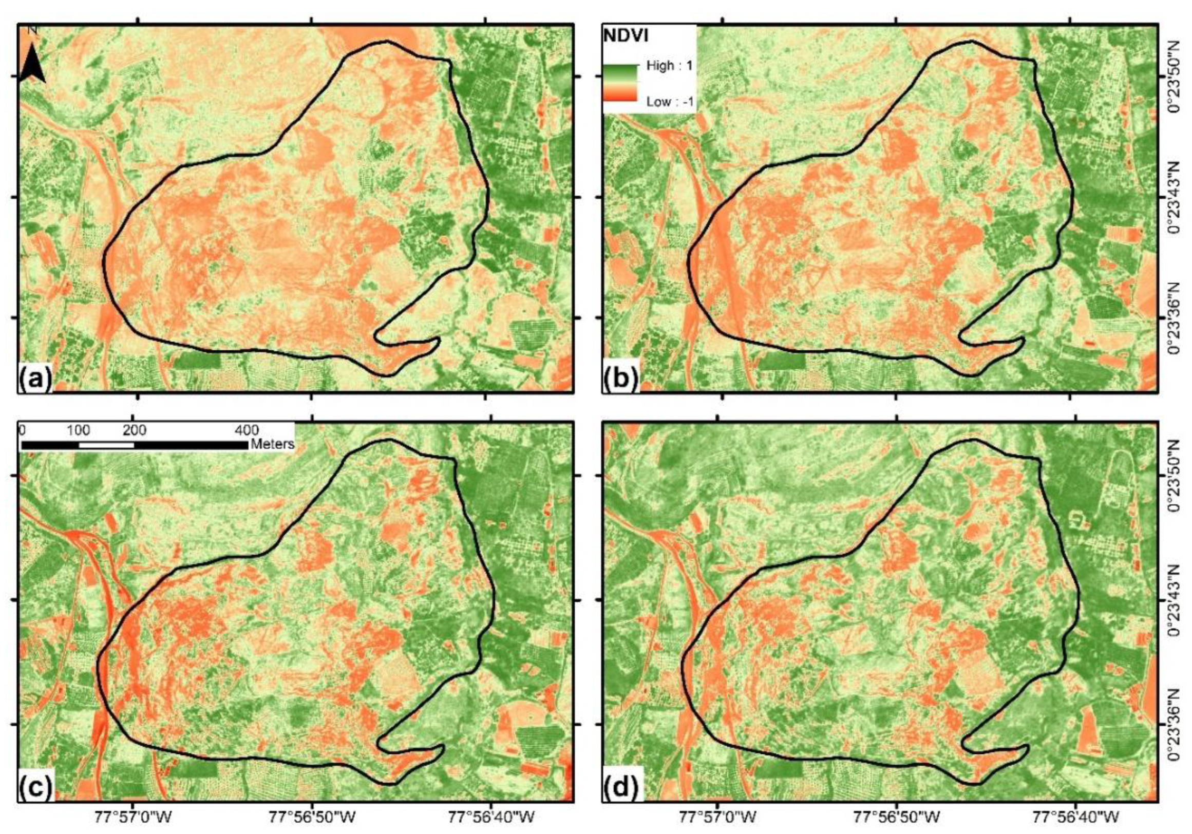
Figure 7.
Variation in surface occupation percentage corresponding to NDVI values.
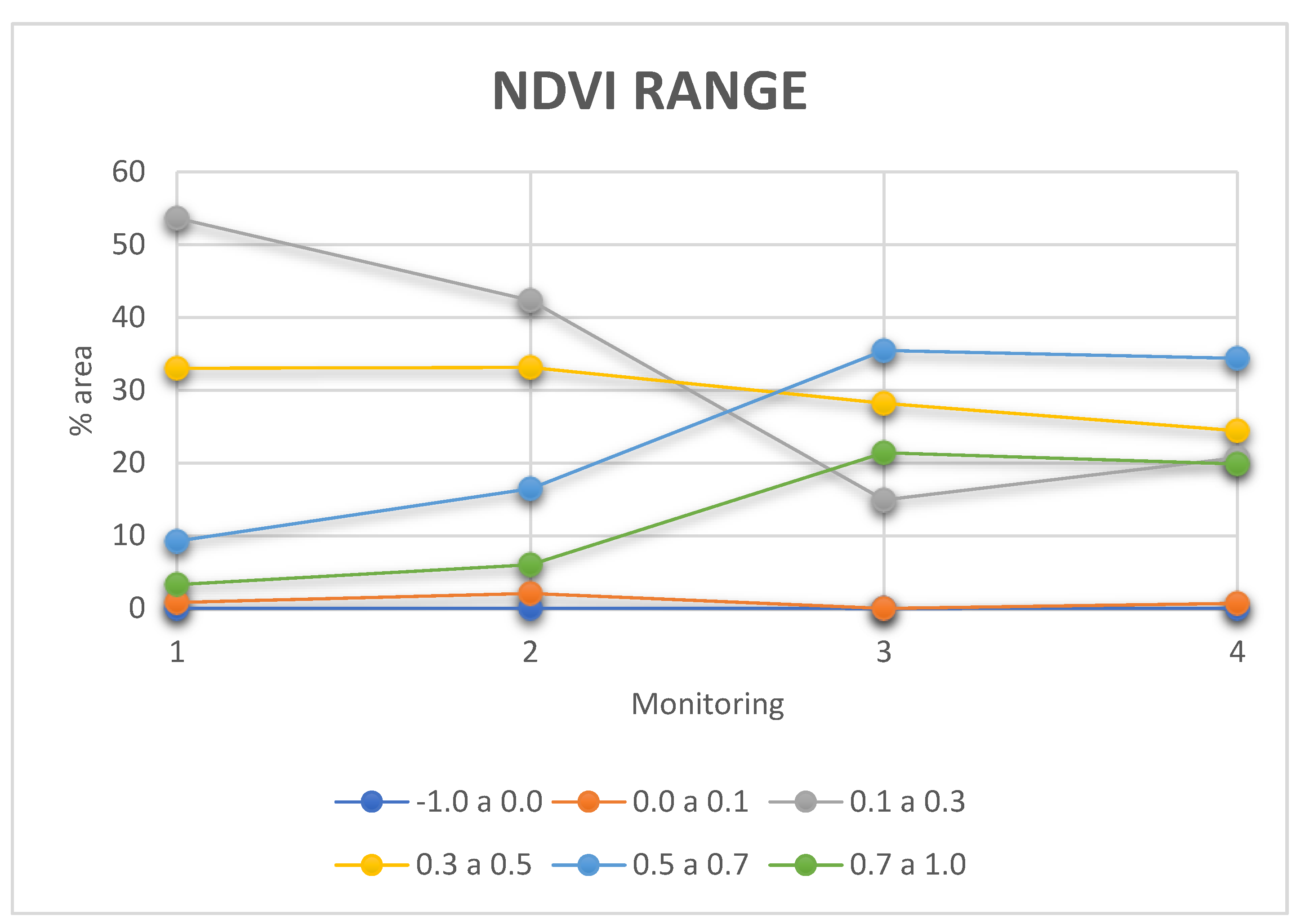
Figure 8.
Variation in surface occupation percentage corresponding to NDWI values.
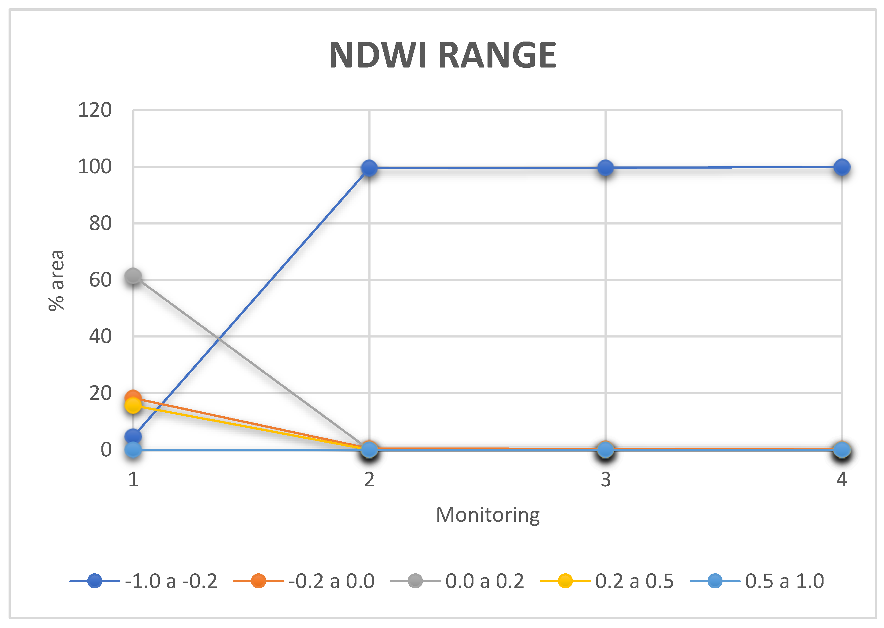

Table 1.
Parameters for flight campaigns.
| Flight parameters | |
|---|---|
| Flight altitude | 293 metres |
| Speed (m/s) | 10m/s |
| GSD | 8 cm/pixel |
| Overlap | 70% |
| Flight time | 15 minutos |
| Number of photos | 2947 |
Table 2.
Formulas for the Calculation of Spectral Indices Commonly Used in Remote Sensing.
| Multi-spectral indices | Formula | Reference |
|---|---|---|
| Normalized Vegetation Indices (NDVI) | [49] | |
| Normalized Difference Water Index (NDWI) | [50] |
Table 3.
Continuous monitoring of control points P01, P02, P03, P06, and P10 (2022–sixth monitoring).
Table 3.
Continuous monitoring of control points P01, P02, P03, P06, and P10 (2022–sixth monitoring).
| Mon | P01 | P02 | P03 | P06 | P10 | |||||
|---|---|---|---|---|---|---|---|---|---|---|
| Dis | Hea | Dis | Hea | Dis | Hea | Dis | Hea | Dis | Hea | |
| I | - | - | - | - | - | |||||
| II | 0,009 | S13W | 0,006 | N9W | 0,018 | N13W | 0,041 | N43W | - | |
| III | 0,015 | S67E | 0,012 | N20E | 0,024 | N2W | 0,039 | N27W | 0,013 | N51E |
| IV | 0,005 | S22E | 0,006 | N45E | 0,018 | N16W | 0,036 | N9W | 0,005 | N79E |
| V | 0,005 | S11E | 0,005 | S68E | 0,033 | N41W | - | 0,026 | N74E | |
| VI | 0,009 | N6W | 0,014 | N34E | 0,029 | N6E | - | 0,023 | N75E | |
*Dis: Displacement, Hea: Heading.
Table 4.
Displacements and courses of 11 densified control points in campaign V (September 26, 2024).
Table 4.
Displacements and courses of 11 densified control points in campaign V (September 26, 2024).
| Mon | P04A | P05A | P06A | P07A | P08 | P11 | ||||||
|---|---|---|---|---|---|---|---|---|---|---|---|---|
| Dis | Hea | Dis | Hea | Dis | Hea | Dis | Hea | Dis | Hea | Dis | Hea | |
| V | - | - | - | - | - | - | ||||||
| VI | 0,016 | N72W | 0,021 | S43E | 0,013 | N72W | 0,018 | N49W | 0,010 | N61E | 0,013 | S29E |
| Mon | P15 | P17 | P18 | P19 | P20 | P21 | ||||||
| Dis | Hea | Dis | Hea | Dis | Hea | Dis | Hea | Dis | Hea | Dis | Hea | |
| V | - | - | - | - | - | - | ||||||
| VI | 0,050 | S26W | 0,008 | S60E | 0,013 | N67W | 0,049 | N58W | 0,066 | N72W | 0,011 | N56W |
*Dis: Displacement, Hea: Heading.
| NDWI Range | Category | Interpretation |
|---|---|---|
| -1.0 a -0.2 | Non-water surfaces | Dry soil, urban areas, rocks or non-water related vegetation. |
| -0.2 a 0.0 | Low moisture/wet soil | Areas with some moisture but no free bodies of water (e.g., soil after rain). |
| 0.0 a 0.2 | Turbid water or wet vegetation | Flooded areas, rice fields, or water with sediment. |
| 0.2 a 0.5 | Surface water bodies | Lakes, rivers, or reservoirs with clear or moderately turbid water. |
| 0.5 a 1.0 | Clear water or aquatic vegetation | Deep, clear water (e.g., oceans, crystal clear lakes) or dense wetlands. |
Table 6.
caption.
| NDVI Range | Category | Interpretation |
|---|---|---|
| 0.0 a 0.1 | Bare ground or dead vegetation | Arid, desert or dry vegetated areas. |
| 0.1 a 0.3 | Sparse/low density vegetation | Dry grasslands, stressed vegetation or vegetation in early growth stage. |
| 0.3 a 0.5 | Moderate Vegetation | Shrubs, developing crops or growing vegetation. |
| 0.5 a 0.7 | Dense/healthy vegetation | Forests, mature crops, or vegetation at its peak. |
| 0.7 a 1.0 | Very dense vegetation | Selvas tropicales, bosques húmedos o vegetación extremadamente saludable. |
| 0.0 a 0.1 | Bare ground or dead vegetation | Arid, desert or dry vegetated areas. |
Disclaimer/Publisher’s Note: The statements, opinions and data contained in all publications are solely those of the individual author(s) and contributor(s) and not of MDPI and/or the editor(s). MDPI and/or the editor(s) disclaim responsibility for any injury to people or property resulting from any ideas, methods, instructions or products referred to in the content. |
© 2025 by the authors. Licensee MDPI, Basel, Switzerland. This article is an open access article distributed under the terms and conditions of the Creative Commons Attribution (CC BY) license (https://creativecommons.org/licenses/by/4.0/).
Copyright: This open access article is published under a Creative Commons CC BY 4.0 license, which permit the free download, distribution, and reuse, provided that the author and preprint are cited in any reuse.


